Embed Size (px)
Citation preview
Distribution: The Corporation of the City of Oshawa – 1 Copy Ontario Ministry of Tourism, Culture and Sport – 1 Electronic Copy AMEC Environment & Infrastructure - 1 Copy
ORIGINAL REPORT: STAGE 1 BACKGROUND STUDY AND PROPERTY INSPECTION:
CONLIN ROAD EAST FROM SIMCOE STREET NORTH TO THE EAST CITY LIMIT, LOTS 1-12, Part Lot 13,
CONCESSIONS 4&5 HISTORICAL COUNTY OF ONTARIO, GEOGRAPHIC TOWNSHIP
OF DURHAM, OSHAWA, ONTARIO
Submitted to:
The Corporation of the City of Oshawa 50 Centre Street South, 7th Floor
Oshawa, Ontario L1H 3Z7
AND
THE ONTARIO MINISTRY OF TOURISM, CULTURE AND SPORT
Submitted by: AMEC Environment and Infrastructure, a Division of AMEC Americas Limited,
505 Woodward Avenue, Unit 1 Hamilton, Ontario, L8H 6N6
Phone: (905) 312-0700 Fax: (905) 312-0771
Archaeological Consulting License # P141 (Austin) P.I.F. # P141-182-2013
AMEC Project # TP113039.3000 21 August 2013
The Corporation of the City of Oshawa Stage 1 Background Study and Property Inspection: Conlin Road East from Simcoe Street North to the east City Limit, Oshawa, Ontario
Project Number TP113039.3000 Page i
EXECUTIVE SUMMARY
AMEC Environment & Infrastructure, a division of AMEC Americas Limited (AMEC), was retained by City of Oshawa (the CLIENT) to conduct a Stage 1 background study and property inspection in conjunction with a Schedule C Class Environmental Assessment on a portion of Conlin Road East, from Simcoe Street North to the east City limit, in Oshawa, Ontario.
In 1995, the City of Oshawa conducted reconstruction along Conlin Road from Simcoe Street north to Ritson Road north and created a two lane urban cross-section including turning lanes at appropriate locations. The remainder of Conlin Road exists with its original structure with various levels of surface treatment. Increased traffic volumes related to both residential and commercial development, Durham College expansion, the extension of Highway 407 East Phase 1, combined with the deteriorating pavement conditions as well as safety and drainage issues, lead the City of Oshawa to consider the need for further improvements to Conlin Road within the City limits.
The study area contains six major intersections; Simcoe Street North, Ritson Road North, Wilson Road North, Harmony Road North, Grandview Street North, and Townline Road North. The study area also contains crossings of two branches of the Oshawa Creek and two branches of Harmony Creek. Samac Lake is also within the vicinity of the study area. Land use adjacent to the road consists of single family residential homes, commercial/retail, institutional buildings, and farm land. Hydro poles, light standards, and other utilities, are located adjacent to the existing roadway.
The Stage 1 background study and property inspection was conducted under an Ontario Professional Licence to Conduct Archaeological Fieldwork (P141) held by Dr. Shaun Austin, Associate Archaeologist at AMEC. The project information was acknowledged by the Ministry of Tourism, Culture, and Sport (MTCS) on 24 April 2013 with the approval of PIF number P141-182-2013. The background research and field inspection were conducted under the co-direction of Mr. Jason Seguin (P354) and Ms. Cara Howell (R180) on 30 April 2013. The weather on that day ranged from overcast to partly overcast skies and cool conditions. The weather conditions did not impede the Stage 1 property inspection in any way.
The Stage 1 background study and property assessment was triggered under the Environmental Assessment act and was conducted prior to development. The Stage 1 background study and property inspection indicates that 59% (11.30 hectares) of the study area has archaeological potential. Additionally, there are several creek crossings within the study area associated with Oshawa Creek and Harmony Creek. Samac Lake

The Corporation of the City of Oshawa Stage 1 Background Study and Property Inspection: Conlin Road East from Simcoe Street North to the east City Limit, Oshawa, Ontario
Project Number TP113039.3000 Page ii
is also within the vicinity of the study area. These factors add to the potential for the discovery of archaeological sites.
Approximately 41% (7.90 hectares) has had archaeological potential removed by recent land alterations, utility installations and modern construction activities.
In light of these results, the following recommendations are made:
1) Prior to development-related disturbance, a Stage 2 archaeological assessment should be conducted by means of shovel test pit survey in accordance with Section 2.1.2 in the Standards and Guidelines for Consultant Archaeologists (2011) on those areas noted as having archaeological potential in Appendix A: Figures 4a-j.
2) The balance of the study area does not require additional archaeological assessment.
The above recommendations are subject to Ministry of Tourism, Culture and Sport approval, and it is an offence to alter any of the study area without Ministry of Tourism, Culture, and Sport concurrence.
The Corporation of the City of Oshawa Stage 1 Background Study and Property Inspection: Conlin Road East from Simcoe Street North to the east City Limit, Oshawa, Ontario
Project Number TP113039.3000 Page iii
PROJECT PERSONNEL
Project Director: Jason Seguin, M.A. (P354) Project Manager: Jason Seguin, M.A. Field Director: Cara Howell, B.A. (R180) Report Preparation: Jason Seguin, M.A. Graphics: Cara Howell, B.A. Report Reviewer: Shaun Austin, Ph.D. (P141)

The Corporation of the City of Oshawa Stage 1 Background Study and Property Inspection: Conlin Road East from Simcoe Street North to the east City Limit, Oshawa, Ontario
Project Number TP113039.3000 Page iv
TABLE OF CONTENTS
EXECUTIVE SUMMARY ................................................................................................. I
PROJECT PERSONNEL ............................................................................................... III
1.0 PROJECT CONTEXT .......................................................................................... 5 1.1 Development Context ............................................................................ 5
1.1.1 Scope of Work ............................................................................ 6 1.1.2 Physical Setting .......................................................................... 7
1.2 Historical Context .................................................................................. 8 1.2.1 Review of Historical Records .............................................................. 11 1.3 Archaeological Context ....................................................................... 14
2.0 STAGE 1 FIELD METHODS ............................................................................. 17
3.0 RECORD OF FINDS ......................................................................................... 18
4.0 STAGE 1 ANALYSIS AND CONCLUSIONS ..................................................... 19
5.0 RECOMMENDATIONS ..................................................................................... 20
6.0 ADVICE ON COMPLIANCE WITH LEGISLATION ........................................... 22
7.0 ASSESSOR QUALIFICATIONS ........................................................................ 23
8.0 CLOSURE ......................................................................................................... 24
9.0 BIBLIOGRAPHY AND SOURCES .................................................................... 26
LIST OF TABLES Table 1: Summary of Residents and Features............................................................... 12 Table 2: Registered Archaeological Sites within a One-Kilometre Radius ..................... 15 Table 3: Inventory of Documentary Record ................................................................... 18 APPENDICES APPENDIX A: FIGURES
Figure 1 Aerial Photograph showing the Location of the Study Area Figure 2 1860 Tremaine Map of the County of Ontario Showing the Location of the
Study Area Figure 3 1877 Illustrated Historical Atlas of the County of Ontario showing the
Location of the Study Area Figure 4a-j Results of the Stage 1 Property Assessment with Photographic Locations
and Directions APPENDIX B: PHOTOGRAPHS APPENDIX C: ASSESSOR QUALIFICATIONS APPENDIX D: LIMITATIONS

The Corporation of the City of Oshawa Stage 1 Background Study and Property Inspection: Conlin Road East from Simcoe Street North to the east City Limit, Oshawa, Ontario
Project Number TP113039.3000 Page 5
1.0 PROJECT CONTEXT
1.1 Development Context
AMEC Environment & Infrastructure, a division of AMEC Americas Limited (AMEC), was retained by City of Oshawa (the CLIENT) to conduct a Stage 1 background study and property inspection in conjunction with a Schedule C Class Environmental Assessment on a portion of Conlin Road East, from Simcoe Street North to the east City limit, in Oshawa, Ontario.
In 1995, the City of Oshawa conducted reconstruction along Conlin Road from Simcoe Street north to Ritson Road north and created a two lane urban cross-section including turning lanes at appropriate locations. The remainder of Conlin Road exists with its original structure with various levels of surface treatment. Increased traffic volumes related to both residential and commercial development, Durham College expansion, the extension of Highway 407 East Phase 1, combined with the deteriorating pavement conditions as well as safety and drainage issues lead the City of Oshawa to consider the need for further improvements to Conlin Road within the City limits.
The study area contains six major intersections; Simcoe Street North, Ritson Road North, Wilson Road North, Harmony Road North, Grandview Street North, and Townline Road North. The study area also contains crossings of two branches of the Oshawa Creek and two branches of Harmony Creek. Samac Lake is also within the vicinity of the study area. Land use adjacent to the road consists of single family residential homes, commercial/retail, institutional buildings, and farm land. Hydro poles, light standards, and other utilities, are located adjacent to the existing roadway.
The Stage 1 background study and property inspection was conducted under an Ontario Professional Licence to Conduct Archaeological Fieldwork (P141) held by Dr. Shaun Austin, Associate Archaeologist at AMEC. The project information was acknowledged by the Ministry of Tourism, Culture, and Sport (MTCS) on 24 April 2013 with the approval of PIF number P141-182-2013. The background research and field inspection were conducted under the co-direction of Mr. Jason Seguin (P354) and Ms. Cara Howell (R180) on 30 April 2013. The weather on that day ranged from overcast to partly overcast skies and cool conditions. The weather conditions did not impede the Stage 1 property inspection in any way. All aspects of the Stage 1 assessment were conducted in accordance with the MTCS’s Standards and Guidelines for Consultant Archaeologists (2011). This report presents the results of the Stage 1 background study and property inspection, and makes pertinent recommendations.

The Corporation of the City of Oshawa Stage 1 Background Study and Property Inspection: Conlin Road East from Simcoe Street North to the east City Limit, Oshawa, Ontario
Project Number TP113039.3000 Page 6
1.1.1 Scope of Work
A Stage 1 archaeological assessment is a systematic qualitative process executed in order to assess the archaeological potential of a property based on its historical use and its potential for early Euro-Canadian (early settler) and pre-contact Aboriginal occupation. The objectives of a Stage 1 background study are: 1) to provide information about the property’s geography, history, previous archaeological fieldwork and current land condition; 2) to evaluate in detail the property’s archaeological potential which will support recommendations for Stage 2 property assessment for all or parts of the property if warranted; and, 3) to recommend appropriate strategies for Stage 2 property assessment if warranted.
The Stage 1 background study was conducted in accordance with the Standards and Guidelines for Consultant Archaeologists, 2011, set out by the MTCS, and with the Ontario Heritage Act, R.S.O. 1990, c.0.18.
The scope of work for the Stage 1 background study consisted of the following tasks:
Contacting the MTCS to determine if recorded archaeological sites exist in the vicinity (1 km radius) of the property, through a search of the Ontario Archaeological Sites Database maintained by that Ministry;
Contacting the MTCS to determine if there are any known reports of previous archaeological field work within a radius of 50m around the study area;
A desktop review of the study area’s physical setting to determine its potential for both historic and pre-contact human occupation, including its topography, hydrology, soils, vegetation, and proximity to important resources and historic transportation routes;
A visual assessment of the study area in order to gather first-hand and current evidence of the property’s physical setting, and to aid in delineating areas where archaeological potential may have been impacted or removed by previous land-use practices;
Mapping, photographing and other relevant graphics;
A review of the potential for historic occupation as documented in historical atlases and other archival sources; and
Preparing a report of findings with recommendations regarding the need for further archaeological work if deemed necessary.
The Corporation of the City of Oshawa Stage 1 Background Study and Property Inspection: Conlin Road East from Simcoe Street North to the east City Limit, Oshawa, Ontario
Project Number TP113039.3000 Page 7
1.1.2 Physical Setting
The study area (Appendix A: Figures 1 and 2) is situated along the interface between the South slope and the Iroquois plain physiographic regions of Ontario (Chapman and Putnam 1984: 113). The South Slope physiographic region spans an area of approximately 2400 km2 extending from the Oak Ridge Moraine to the north towards Lake Ontario to the south, and from the Niagara Escarpment to the west towards the Trent River to the east. The South Slope is the southern slope of the Oak Ridges Moraine. It lies across the limestones of the Verulam and Lindsay Formations, the grey shales of the Georgian Bay Formation, and the reddish shales of the Queenston Formation. The Regional Municipality of Durham contains calcareous clay till, containing few stones and likely consisting of lacustrine clay and silt reworked by the glacier (Chapman and Putnam 1984: 173).
The South Slope contains a variety of soils that have proven to be excellent for agricultural use for more than a century. The lands of the South slope are more sandy and steeper in the east and more clayey in the west. The South slope is mostly drumlinized, containing smooth oval hills of glacial deposits. Due to its rich soils, the South Slope was colonized by the “second wave” of immigrants to Upper Canada, composed mostly of British immigrants after the close of the Napoleonic wars. A mixed, subsistence agriculture was common in early settlement, but grain soon began to be exported and roads were improved as a result. The period of grain growing was a period of prosperity and many fine fieldstone houses were built throughout the region. After some time, wheat farming was replaced by commercial mixed farming, where beef cattle, hogs and dairy butter were the chief sources of income.
The region is now coming under rapid urban expansion. The eastern part of the South slope region has managed to maintain some of its rural character, whereas the western part has become more urbanized, likely due to its proximity to Toronto.
The Iroquois Plain extends around the western part of Lake Ontario, from the Niagara River to the Trent River, a distance of approximately 300 kilometres. The Iroquois Plain was formed when the last glacier was receding but still occupied the St. Lawrence Valley. The lowland area bordering the current Lake Ontario was inundated with a body of water known as “Lake Iroquois”. Conditions in the old lake plain vary considerably, so it is usually divided into a number of sub-sections. However, across the Regional Municipality of Durham the Iroquois plain has a fairly constant pattern. The old shoreline is well marked by bluffs or gravel bars, while immediately below it are a strip of boulder pavement and sandy offshore deposits. The coarse sandy soil is fairly level and often poorly drained and, therefore, is not very productive (Chapman and Putnam, 1984: 193). An exception, however, is provided by the dry sandy terrace north of Oshawa, in the vicinity of the subject study area. This would explain the seemingly prosperous

The Corporation of the City of Oshawa Stage 1 Background Study and Property Inspection: Conlin Road East from Simcoe Street North to the east City Limit, Oshawa, Ontario
Project Number TP113039.3000 Page 8
agricultural community in the area, both historically and present day. The Iroquois plain was a popular area for early settlement as its easy grades were conducive to the building of transportation routes, such as roads and railways. These routes linked the lakefront settlements and resulted in the growth of large centres like Toronto and Hamilton. In addition, the old sandbars and offshore aprons of sand are good aquifers, supplying domestic water to its residents for farms, villages and some towns. The gravel bars have been good sources of road metal and building materials, while the clays of the old lake bed have been used in the manufacture of bricks (Chapman and Putnam, 1984: 196).
The physical differences between the South Slope and the Iroquois Plain in this area are not sufficient to promote much difference in agricultural practices. Orchards and canning crops are grown in both areas and general livestock and crop patterns are widespread. The entire slope from the Oak Ridge Moraine to the lakeshore can be considered one geographic unit with a series of strategically placed lakeshore towns. The entirety of the area extending east of Toronto and into the Region of Durham can be said to lie within the “urban shadow” (Putnam 1962).
Currently the study area is composed of residential and commercial buildings and associated lots, numerous paved spaces, public park spaces and municipal buildings.
1.2 Historical Context
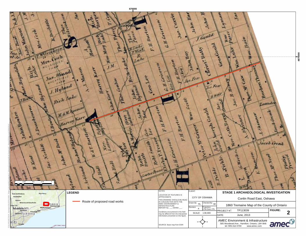
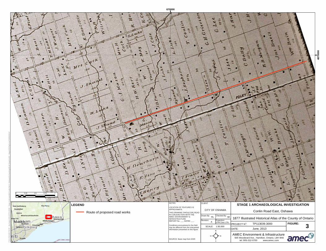
The study area comprises Lots 1 to 12 and Part Lot 13, Concessions IV-V, in the (former) geographic Township of East Whitby, Regional Municipality of Durham (former County of Ontario). The study area is a linear east/west corridor of land that correlates to the historic transportation route that divided Concession IV and V in the former County of Ontario (Appendix A: Figures 2 and 3). Historical records and mapping were examined for evidence of early Euro-Canadian land use in the study area.
County of Ontario:
The 1877 Atlas describes the County of Ontario as being situated “as near as may be, midway between the eastern and western boundaries on the frontier” (J. H. Beers & Co., 1877: 3). The County of Ontario came into existence on January 1st, 1854. Up until 1852, it was included in and formed part of the County of York. The name for the County was derived from the smallest of the Great Lakes and included the three harbours of Whitby, Frenchman’s Bay, and Oshawa. According to the 1877 Atlas, the County was comprised of the following municipalities: Reach, Brock, Uxbridge, Scott, Scugog, Thorah, Mara and Rama, and the incorporated villages of Port Perry, Uxbridge, and Cannington in the north; Whitby, East Whitby, Pickering the town of Whitby and village of Oshawa in the south.
The Corporation of the City of Oshawa Stage 1 Background Study and Property Inspection: Conlin Road East from Simcoe Street North to the east City Limit, Oshawa, Ontario
Project Number TP113039.3000 Page 9
Early settlement in the County is linked to the harbour and the business it brought about. The harbour grew in importance as a trade centre with both natives and later with the neighbouring United States. Ontario County’s first farmers and traders were not Europeans or Loyalists. Instead, the first farmers and businessmen were members of the Indian nations of the Huron and Iroquois Confederacies. During the 15th and 16th centuries, before Europeans had immigrated into the area, southern Ontario and New York State were inhabited by a number of Indian nations who spoke varieties of the Iroquoian language. Over the years, they had gradually divided into two rival trading alliances separated by the lower Great Lakes (Johnson, 1973: 1). The County’s favourable position close to the lake and its fertile soil began to attract settlers. The population began to grow and though most had come with the intention of becoming farmers, many were forced by circumstances to become backwoodsmen as well. The struggle to clear the forest left profound marks on the social, political and economic organization of the pioneer community. Gradually these attitudes and institutions, isolated from other centres by distance and poor communications, developed into a community on which the local inhabitants based an intense pride and identity which prevailed for generations (Johnson, 1973: 53).
In the early years, many settlers were forced to depend on non-agricultural pursuits for much of their income. Many became traders, surveyors, labourers and teamsters on government projects. Others set up small shops or taverns in rooms in their houses as a means of adding to their incomes. However, by the early 19th century, much of the land in the county had been cleared. By the mid 19th century, for most areas the pioneer period had ended and been replaced by rapid growth. The development of a good system of transportation and commercial agricultural had begun. Roads were improved, old villages expanded and new villages sprang up. By 1850, Ontario County had begun to take on its modern face (Johnson, 1973: 128).
Conlin Road is an early east-west transportation route, developed with the network of concession roads and railroads during the course of the nineteenth century. Such early transportation routes influenced the settling of farmsteads, businesses and early communities. Early Euro-Canadian history in the area is recorded on the City of Oshawa’s website as follows: In the early 18th century, the Mississauga Indians traded furs with the French and English. They loaded their canoes from a spot in the not-too-distant Oshawa Harbour and paddled their way along the shores of Lake Ontario to the trading post at the mouth of the Credit River. This trading route became so important that the French established a trading post at the mouth of the Oshawa Creek around 1750. Thus began the economic history of exporting products from the region now known as the City of Oshawa.
United Empire Loyalists began making their way to this pioneer community and helped establish the Village of Oshawa as a commercial centre. As immigration to the area
The Corporation of the City of Oshawa Stage 1 Background Study and Property Inspection: Conlin Road East from Simcoe Street North to the east City Limit, Oshawa, Ontario
Project Number TP113039.3000 Page 10
increased, people began to develop mills along the banks of the many local water sources in the nearby countryside. As farmers prospered, the need for other services grew. Hotels, inns, stores, churches, tanneries, distilleries, and additional mills began to emerge. In 1840, the first pier and breakwater was constructed in Oshawa Harbour by the Syndenham Harbour Company. In 1842, the residents applied to the Government for the establishment of a post office, and decided on the name Syndenham, by which the wharf was known. However, local history cites that the name “Oshawa” was chosen by two visiting natives who suggested the Indian name, meaning “that point at the crossing of the stream where the canoe was exchanged for the trail”. The suggestion was immediately accepted and the village was incorporated in 1850 with a population of 2,000. In the eleven years from 1840 to 1851 Ontario County’s population grew from 12,015 to 29,571. In the northern areas the increase was particularly dramatic. 1851 was the peak of population growth. This period of growth fundamentally altered the composition of the area’s society because many of the original American settlers died during this decade and because the great majority of new settlers were natives of the British Isles, particularly England and Ireland (Johnson, 1973: 129).
With the influx of immigrants, land soon became scarce in the more settled areas and new settlers were forced to take up land in the previously neglected areas, such as Scott and Rama Townships.
While the population continued to grow after 1851, it did so at a much slower rate. Indeed, after 1861 population growth slowed almost to a standstill. Between 1861 and 1871 a decline in the rural population of the southern townships had begun. Only in the northern areas and the towns of Whitby and Oshawa did growth continue, but at a very slow rate (Johnson, 1973: 128). However, in the two decades after 1851, most residents of Ontario County experienced years of great prosperity, change, optimism and self satisfaction (Johnson, 1973: 196). Almost all of the economic expansion occurred in the first decade while the economy remained relatively static in the second. During this period there were also dramatic changes to rural society and economy in Ontario County. Several large scale industries were established during this time. During this time, the nearby City of Toronto grew at a phenomenal rate which contributed to the expansion of a railway network across south and central Ontario. At this time, Ontario County industries had a competitive advantage over Toronto’s industries due to lower costs for shipment of many goods and many industries thrived. While the period 1851-1871 brought about a fundamental alteration of life in Ontario County with the introduction of mechanized agriculture, the rise of villages, the industrialization of Oshawa, the building of railroads, and the creation of new educational and moral systems, its economic autonomy began to diminish and the area became more of a satellite of Toronto (Johnson, 1973: 317). In 1879, Oshawa became officially known as a town.
The Corporation of the City of Oshawa Stage 1 Background Study and Property Inspection: Conlin Road East from Simcoe Street North to the east City Limit, Oshawa, Ontario
Project Number TP113039.3000 Page 11
Township of East Whitby:
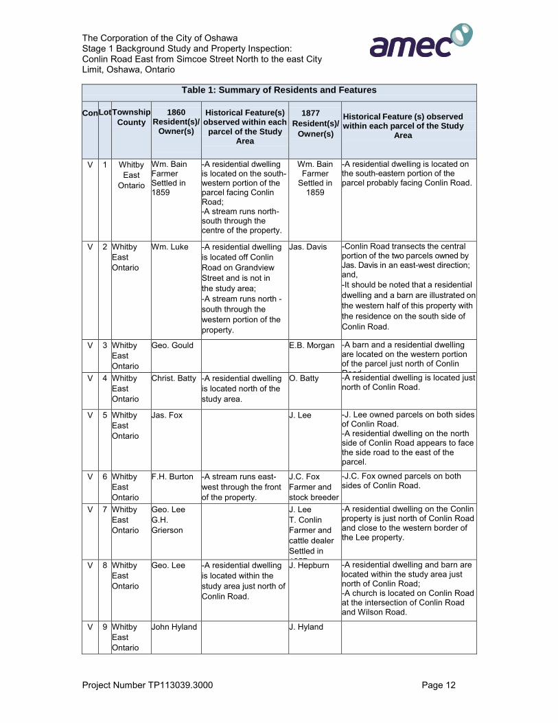
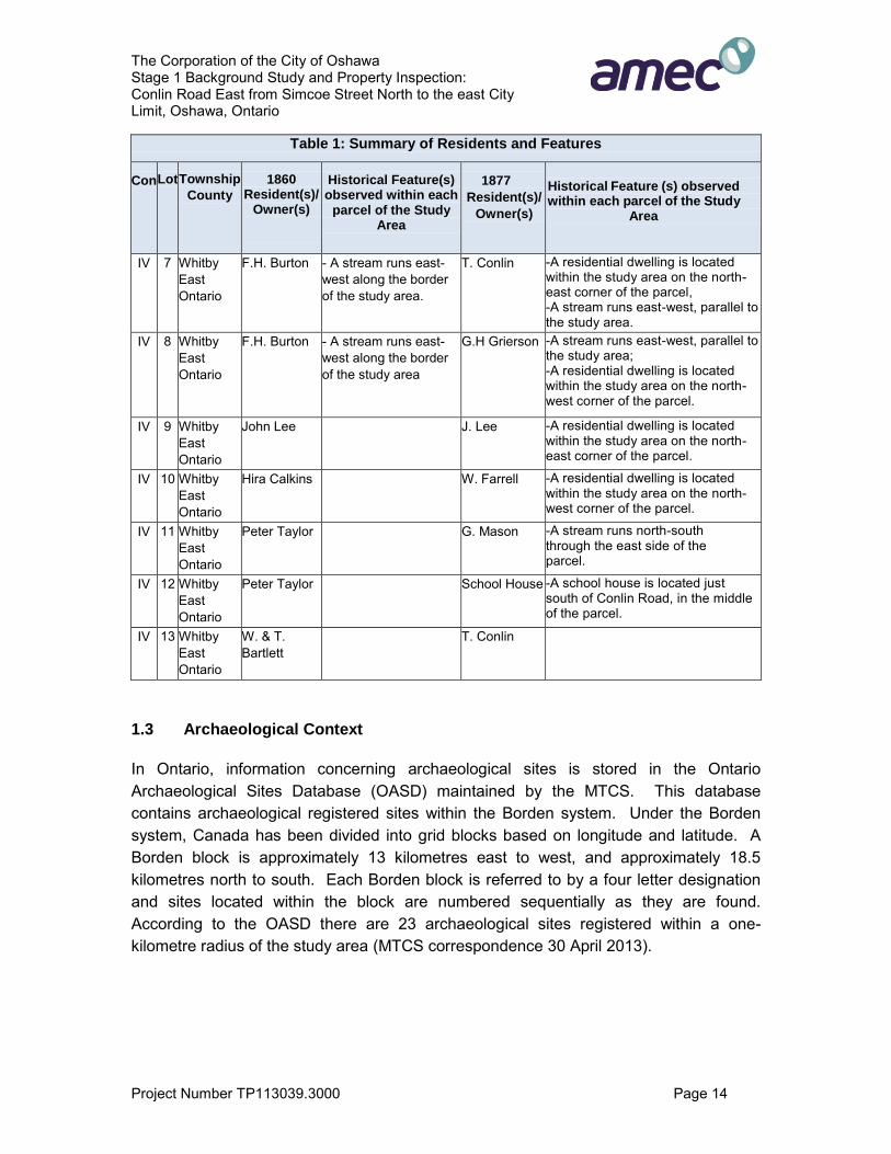
Whitby Township (Township No. 8) was initially surveyed in 1791. The Township of East Whitby separated from Whitby Township in 1858. The Township of East Whitby comprised an area of 34,700 acres and extended from the Lake Ontario shoreline to Raglan in the north and from Thornton Road in the west to the Darlington Townline in the east, excluding the Town of Oshawa. East Whitby Township was classified by agriculture, with regular farmsteads and field patterns that followed original land grants for the most part. The Tremaine map of 1860 and the 1877 Illustrated Historical Atlas map (Appendix A: Figures 2 and 3) show a well-established agricultural landscape along Conlin Road. The 1877 Atlas shows a number of structures within the study area, including several homesteads, a church and a school. There are no cemeteries shown on the map. However, it should be noted that not all features of interest were mapped systematically on the Ontario series of historical maps and atlases, as they were financed by subscription. Subscribers were given preference with regard to the level of detail provided on the maps. In addition, not every feature of interest would have been within the scope of the 1877 Atlas.
Oshawa’s industries continued to grow, particularly with the arrival of the Grand Trunk Railway line from Toronto to Montreal. In the early 20th century, automobile, horse breeding, and other significant industries flourished in Oshawa (Source: http://www.oshawa.ca/tourism/history3.asp).
The soils of East Whitby Township consisted generally of a loamy clay, considered to be “very fruitful, the water good, and the climate healthy, making it one of the most desirable agricultural locations in the Dominion” (Beers, 1877: 11). Oshawa was the first village incorporated in the county and comprised an area of 971 hectares (2,400 acres). East Whitby enjoyed the benefits of very fruitful agricultural land that was well tilled and well stocked. Most farmers had comfortable dwellings and large roomy barns with orchards and gardens.
1.2.1 Review of Historical Records
The 1860 Tremaine Map of the County of Ontario and 1877 Historical Atlas of the County of Ontario were examined in an effort to determine the potential for heritage resources within the study area (Appendix A: Figures 2 and 3). By the 1870s the study area consisted of various parcels corresponding to Part of Lots 1 to 13, Concessions IV-V, in the geographical Township of East Whitby, County of Ontario.
The following table provides a summary of residents and features identified within these parcels:
The Corporation of the City of Oshawa Stage 1 Background Study and Property Inspection: Conlin Road East from Simcoe Street North to the east City Limit, Oshawa, Ontario
Project Number TP113039.3000 Page 12
Table 1: Summary of Residents and Features
Con
Lot
Township
County
1860
Resident(s)/ Owner(s)
Historical Feature(s) observed within each
parcel of the Study Area
1877
Resident(s)/
Owner(s)
Historical Feature (s) observed within each parcel of the Study
Area
V 1 Whitby East
Ontario
Wm. Bain Farmer Settled in 1859
-A residential dwelling is located on the south-western portion of the parcel facing Conlin Road; -A stream runs north-south through the centre of the property.
Wm. Bain Farmer
Settled in 1859
-A residential dwelling is located on the south-eastern portion of the parcel probably facing Conlin Road.
V 2 Whitby East Ontario
Wm. Luke -A residential dwelling is located off Conlin Road on Grandview Street and is not in the study area; -A stream runs north -south through the western portion of the property.
Jas. Davis -Conlin Road transects the central portion of the two parcels owned by Jas. Davis in an east-west direction; and, -It should be noted that a residential dwelling and a barn are illustrated on the western half of this property with the residence on the south side of Conlin Road.
V 3 Whitby East Ontario
Geo. Gould E.B. Morgan -A barn and a residential dwelling are located on the western portion of the parcel just north of Conlin Road. V 4 Whitby
East Ontario
Christ. Batty -A residential dwelling is located north of the study area.
O. Batty -A residential dwelling is located just north of Conlin Road.
V
5 Whitby East Ontario
Jas. Fox J. Lee -J. Lee owned parcels on both sides of Conlin Road. -A residential dwelling on the north side of Conlin Road appears to face the side road to the east of the parcel.
V
6 Whitby East Ontario
F.H. Burton -A stream runs east-west through the front of the property.
J.C. Fox Farmer and stock breeder Settled in 1840
-J.C. Fox owned parcels on both sides of Conlin Road.
V
7
Whitby East Ontario
Geo. Lee G.H. Grierson
J. Lee T. Conlin Farmer and cattle dealer Settled in 1857
-A residential dwelling on the Conlin property is just north of Conlin Road and close to the western border of the Lee property.
V 8 Whitby East Ontario
Geo. Lee -A residential dwelling is located within the study area just north of Conlin Road.
J. Hepburn -A residential dwelling and barn are located within the study area just north of Conlin Road; -A church is located on Conlin Road at the intersection of Conlin Road and Wilson Road.
V 9 Whitby East Ontario
John Hyland J. Hyland

The Corporation of the City of Oshawa Stage 1 Background Study and Property Inspection: Conlin Road East from Simcoe Street North to the east City Limit, Oshawa, Ontario
Project Number TP113039.3000 Page 13
Table 1: Summary of Residents and Features
Con
Lot
Township
County
1860
Resident(s)/ Owner(s)
Historical Feature(s) observed within each
parcel of the Study Area
1877
Resident(s)/
Owner(s)
Historical Feature (s) observed within each parcel of the Study
Area
V 10 Whitby East Ontario
Thos. Conlin -A stream runs north-east through the property.
J.D. Farrell -A residential dwelling is located within the study area just north of Conlin Road.
V 11 Whitby East Ontario
John Karr Harvey Karr
H.W. Kerr -A residential dwelling and a barn are located within the study area just north of Conlin Road. -A stream runs north-south through the east side of the parcel.
V 12 Whitby East Ontario
A.J. Mason G.J. Mason
V 13 Whitby East Ontario
Harvey Karr J. Shand -A residential dwelling is located on the corner of Conlin Road and Simcoe Street North at the edge of the study area.
IV 1 Whitby East Ontario
Rueben Thomas
-A residential dwelling in located on Townline Road outside of the study area.
Reuben Thomas
-A residential dwelling is located within the study area on the north-west corner of the parcel.
IV 2 Whitby East Ontario
Thos. McGaw
-A residential dwelling is located on Grandview Street outside of the study area.
Jas. Davis -Conlin Road transects the central portion of the two parcels owned by Jas. Davis in an east-west direction; and, -It should be noted that a residential dwelling and a barn are illustrated on the western half of this property with the residence on the south side of Conlin Road.
IV 3 Whitby East Ontario
Jas. R. Henry W.B. McGaw
IV 4 Whitby East Ontario
J.C. Fox - North-west corner of lot shows a blacksmith shop.
J.C. Fox -Approximately four dwellings/barns appear on the north-western section of this parcel.
IV 5 Whitby East Ontario
Joseph Gould
Jas. Gould -A residential dwelling and barn appear on the north-eastern corner of the parcel.
IV 6 Whitby East Ontario
Wm. Scott -North-west corner of lot has a residential dwelling.
T. Scott -A severed parcel in the far north-west corner of the lot contains a residential dwelling. There is also a dwelling/barn near the edge of the study area half way through the parcel.
The Corporation of the City of Oshawa Stage 1 Background Study and Property Inspection: Conlin Road East from Simcoe Street North to the east City Limit, Oshawa, Ontario
Project Number TP113039.3000 Page 14
Table 1: Summary of Residents and Features
Con
Lot
Township
County
1860
Resident(s)/ Owner(s)
Historical Feature(s) observed within each
parcel of the Study Area
1877
Resident(s)/
Owner(s)
Historical Feature (s) observed within each parcel of the Study
Area
IV 7 Whitby East Ontario
F.H. Burton - A stream runs east-west along the border of the study area.
T. Conlin -A residential dwelling is located within the study area on the north-east corner of the parcel, -A stream runs east-west, parallel to the study area.
IV 8 Whitby East Ontario
F.H. Burton - A stream runs east-west along the border of the study area
G.H Grierson -A stream runs east-west, parallel to the study area; -A residential dwelling is located within the study area on the north-west corner of the parcel.
IV 9 Whitby East Ontario
John Lee J. Lee -A residential dwelling is located within the study area on the north-east corner of the parcel.
IV 10 Whitby East Ontario
Hira Calkins W. Farrell -A residential dwelling is located within the study area on the north-west corner of the parcel.
IV 11 Whitby East Ontario
Peter Taylor G. Mason -A stream runs north-south through the east side of the parcel.
IV 12 Whitby East Ontario
Peter Taylor School House -A school house is located just south of Conlin Road, in the middle of the parcel.
IV 13 Whitby East Ontario
W. & T. Bartlett
T. Conlin
1.3 Archaeological Context
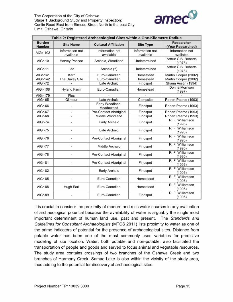
In Ontario, information concerning archaeological sites is stored in the Ontario Archaeological Sites Database (OASD) maintained by the MTCS. This database contains archaeological registered sites within the Borden system. Under the Borden system, Canada has been divided into grid blocks based on longitude and latitude. A Borden block is approximately 13 kilometres east to west, and approximately 18.5 kilometres north to south. Each Borden block is referred to by a four letter designation and sites located within the block are numbered sequentially as they are found. According to the OASD there are 23 archaeological sites registered within a one-kilometre radius of the study area (MTCS correspondence 30 April 2013).
The Corporation of the City of Oshawa Stage 1 Background Study and Property Inspection: Conlin Road East from Simcoe Street North to the east City Limit, Oshawa, Ontario
Project Number TP113039.3000 Page 15
Table 2: Registered Archaeological Sites within a One-Kilometre Radius
Borden Number
Site Name Cultural Affiliation Site Type Researcher
(Year Researched)
AlGq-103 Information not available
Information not available
Information not available
Information not available
AlGr-10 Harvey Pascoe Archaic, Woodland Undetermined Arthur C.B. Roberts (1978)
AlGr-11 Lee Archaic (?) Undetermined Arthur C.B. Roberts (1978)
AlGr-141 Karr Euro-Canadian Homestead Martin Cooper (2002) AlGr-142 The Davey Site Euro-Canadian Homestead Martin Cooper (2002) AlGr-72 - Late Archaic Findspot Shaun Austin (1994)
AlGr-108 Hyland Farm Euro-Canadian Homestead Donna Morrison (1997)
AlGr-179 Flos - - - AlGr-65 Gilmour Late Archaic Campsite Robert Pearce (1993)
AlGr-66 - Early Woodland, Meadowood Findspot Robert Pearce (1993)
AlGr-67 - Pre-Contact Aboriginal Findspot Robert Pearce (1993) AlGr-68 - Middle Woodland Findspot Robert Pearce (1993)
AlGr-74 - Early Archaic Findspot R. F. Williamson (1995)
AlGr-75 - Late Archaic Findspot R. F. Williamson (1995)
AlGr-76 - Pre-Contact Aboriginal Findspot R. F. Williamson (1995)
AlGr-77 - Middle Archaic Findspot R. F. Williamson (1995)
AlGr-78 - Pre-Contact Aboriginal Findspot R. F. Williamson (1995)
AlGr-81 - Pre-Contact Aboriginal Findspot R. F. Williamson (1995)
AlGr-82 - Early Archaic Findspot R. F. Williamson (1995)
AlGr-85 - Euro-Canadian Homestead R. F. Williamson (1995)
AlGr-88 Hugh Earl Euro-Canadian Homestead R. F. Williamson (1995)
AlGr-89 - Euro-Canadian Findspot R. F. Williamson (1995)
It is crucial to consider the proximity of modern and relic water sources in any evaluation of archaeological potential because the availability of water is arguably the single most important determinant of human land use, past and present. The Standards and Guidelines for Consultant Archaeologists (MTCS 2011) lists proximity to water as one of the prime indicators of potential for the presence of archaeological sites. Distance from potable water has been one of the most commonly used variables for predictive modeling of site location. Water, both potable and non-potable, also facilitated the transportation of people and goods and served to focus animal and vegetable resources. The study area contains crossings of two branches of the Oshawa Creek and two branches of Harmony Creek. Samac Lake is also within the vicinity of the study area, thus adding to the potential for discovery of archaeological sites.

The Corporation of the City of Oshawa Stage 1 Background Study and Property Inspection: Conlin Road East from Simcoe Street North to the east City Limit, Oshawa, Ontario
Project Number TP113039.3000 Page 16
Additionally, a request for relevant reports within 50 metres of the study area was also placed. Subsequently the following reports were reviewed:
Stage 1 Archaeological Assessment: Part II Plan for the Kedron Planning Area and Concept Plan for the North Kedron Industrial Area and East Windfields Industrial Area, City of Oshawa, Ontario (ASI, 2009) (PIF# P057-468-2008); and
Stage 1 Archaeological Assessment, Harmony Road Environmental Assessment, Oshawa, Ontario (Stantec, 2010) (PIF# P002-200-2010).

The Corporation of the City of Oshawa Stage 1 Background Study and Property Inspection: Conlin Road East from Simcoe Street North to the east City Limit, Oshawa, Ontario
Project Number TP113039.3000 Page 17
2.0 STAGE 1 FIELD METHODS
AMEC conducted a Stage 1 property inspection conducted under the co-direction of Mr. Jason Seguin (P354) and Ms. Cara Howell (R180) on 30 April 2013 in order to: 1) systematically inspect the study area to identify the presence or absence of features of archaeological potential; 2) to confirm that previously identified features of archaeological potential are present where they were previously identified; 3) to identify and document additional features of archaeological potential not identified on previous mapping; and 4) to determine if modern development and landscaping alterations have affected archaeological potential.
Photographs of field conditions were taken and can be found in Appendix B. The locations and directions of all field photographs are shown in Appendix A: Figures 4a-j. The weather on that day ranged from overcast to partly overcast skies and cool conditions. The weather conditions did not impede the Stage 1 property inspection in any way.

The Corporation of the City of Oshawa Stage 1 Background Study and Property Inspection: Conlin Road East from Simcoe Street North to the east City Limit, Oshawa, Ontario
Project Number TP113039.3000 Page 18
3.0 RECORD OF FINDS
Table 3: Inventory of Documentary Record
Study Area Map and Photo(s) Field Notes
Conlin Road East, from Simcoe Street North to the East City Limit, Lots 1-12,
Part Lot 13, Concessions 4 & 5, Historical County of Ontario,
Geographic Township of Durham, Oshawa, Ontario.
10 field maps, 54 Stage 1 photographs
1 Stage 1 Survey Form, 2 Photo Logs and Field
Notes
Documentation related to the archaeological assessment of this project will be curated by AMEC until such a time that arrangements for their ultimate transfer to Her Majesty the Queen in right of Ontario, or other public institution, can be made to the satisfaction of the project owner, the Ontario Ministry of Tourism, Culture and Sport and any other legitimate interest groups.
The Corporation of the City of Oshawa Stage 1 Background Study and Property Inspection: Conlin Road East from Simcoe Street North to the east City Limit, Oshawa, Ontario
Project Number TP113039.3000 Page 19
4.0 STAGE 1 ANALYSIS AND CONCLUSIONS
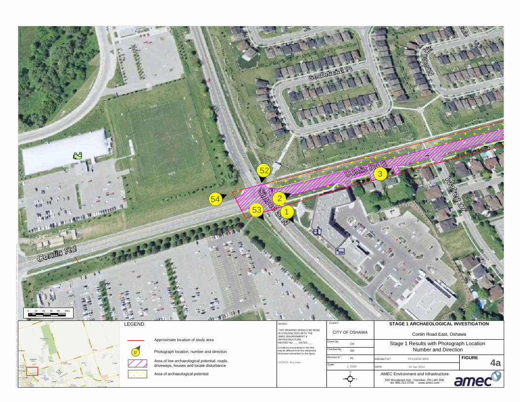
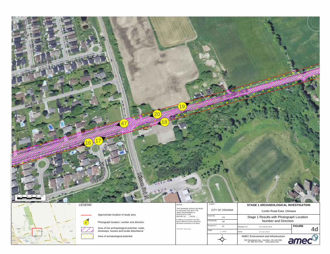
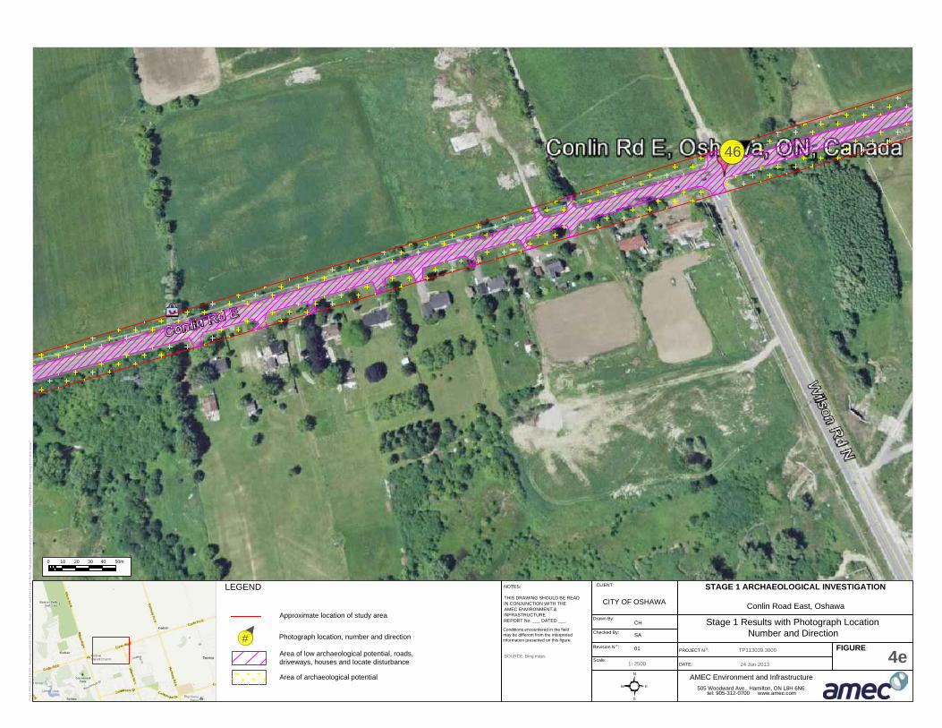
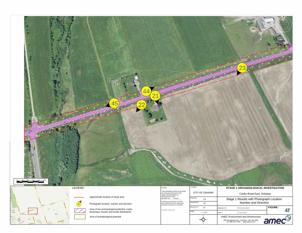
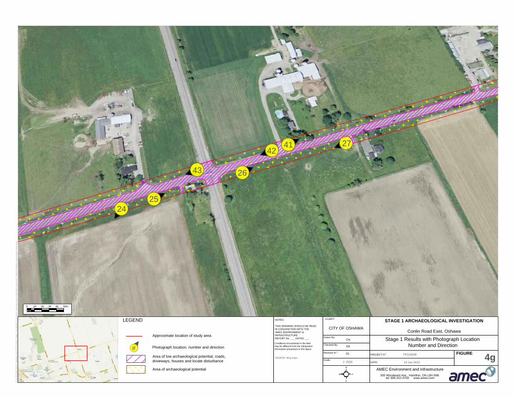
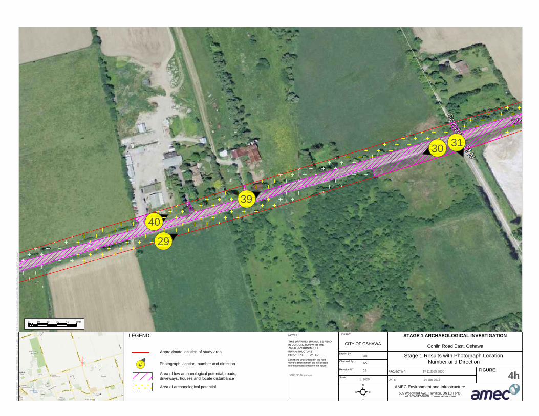
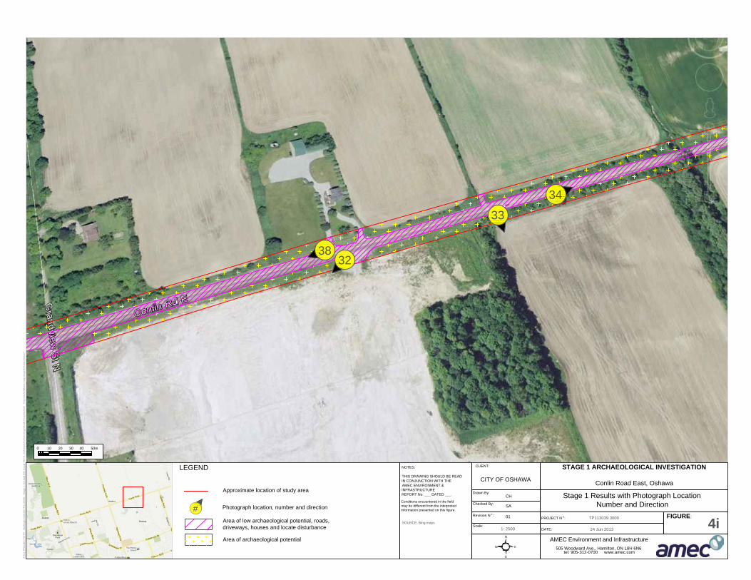
The Stage 1 background study and property inspection indicates that 59% (11.30 hectares) of the study area has archaeological potential (see Appendix A: Figures 4a-j). Additionally, there are several creek crossings within the study area associated with Oshawa Creek and Harmony Creek. Samac Lake is also within the vicinity of the study area. These factors add to the potential for the discovery of archaeological sites.
Stage 1 property inspection also confirmed that approximately 41% (7.90 hectares) of the study area has had archaeological potential removed by recent land alterations and utility installations, including underground utilities, paved roads, residential and commercial buildings, and parking lots. Photographic documentation of the study area is contained in Appendix B.
Any development-related impacts within those portions of the study area noted in Figures 4a-j as having archaeological potential first require a Stage 2 property assessment to be conducted.
The Corporation of the City of Oshawa Stage 1 Background Study and Property Inspection: Conlin Road East from Simcoe Street North to the east City Limit, Oshawa, Ontario
Project Number TP113039.3000 Page 20
5.0 RECOMMENDATIONS
AMEC Environment & Infrastructure, a division of AMEC Americas Limited (AMEC), was retained by City of Oshawa (the CLIENT) to conduct a Stage 1 background study and property inspection in conjunction with a Schedule C Class Environmental Assessment on a portion of Conlin Road East, from Simcoe Street North to the east City limit, in Oshawa, Ontario.
The study area contains six major intersections; Simcoe Street North, Ritson Road North, Wilson Road North, Harmony Road North, Grandview Street North, and Townline Road North. The study area also contains crossings of two branches of the Oshawa Creek and two branches of Harmony Creek. Samac Lake is also within the vicinity of the study area. Land use adjacent to the road consists of single family residential homes, commercial/retail, institutional buildings, and farm land. Hydro poles, light standards, and other utilities, are located adjacent to the existing roadway.
The Stage 1 background study and property inspection indicates that portions of the study area have archaeological potential (59% or 11.3 hectares) (see Appendix A: Figures 4a-j). Additionally, there are several creek crossings within the study area associated with Oshawa Creek and Harmony Creek. Samac Lake is also within the vicinity of the study area. These factors add to the potential for the discovery of archaeological sites.
The visual property inspection confirmed that portions of the study area have had archaeological potential removed (41% or 7.90 hectares) due to existing roadways, driveways, residential homes, underground utility disturbances, and current construction. These areas have been noted in Appendix A: Figures 4a-j.
In light of these results, the following recommendations are made:
1) Prior to development-related disturbance, a Stage 2 archaeological assessment should be conducted by means of shovel test pit survey in accordance with Section 2.1.2 in the Standards and Guidelines for Consultant Archaeologists (2011) on those areas noted as having archaeological potential in Appendix A: Figures 4a-j.
3) The balance of the study area does not require additional archaeological assessment.
The above recommendations are subject to Ministry of Tourism, Culture and Sport approval, and it is an offence to alter any of the study area without Ministry of Tourism, Culture, and Sport concurrence.

The Corporation of the City of Oshawa Stage 1 Background Study and Property Inspection: Conlin Road East from Simcoe Street North to the east City Limit, Oshawa, Ontario
Project Number TP113039.3000 Page 21
No grading or other activities that may result in the destruction or disturbance to the study area is permitted until notice of Ministry of Tourism, Culture and Sport concurrence with the recommendations has been received (Section 5.0).

The Corporation of the City of Oshawa Stage 1 Background Study and Property Inspection: Conlin Road East from Simcoe Street North to the east City Limit, Oshawa, Ontario
Project Number TP113039.3000 Page 22
6.0 ADVICE ON COMPLIANCE WITH LEGISLATION
This report is submitted to the Minister of Tourism, Culture and Sport as a condition of licensing in accordance with Part IV of the Ontario Heritage Act, R.S.O. 1990, c 0.18. The report is reviewed to ensure that it complies with the standards and guidelines that are issued by the Minister, and that the archaeological fieldwork and report recommendations ensure the conservation, protection and preservation of the cultural heritage of Ontario. When all matters relating to archaeological sites within the project area of a development proposal have been addressed to the satisfaction of the Ministry of Tourism and Culture, a letter will be issued by the ministry stating that there are no further concerns with regard to alterations to archaeological sites by the proposed development.
It is an offence under Sections 48 and 69 of the Ontario Heritage Act for any party other than a licensed archaeologist to make any alteration to a known archaeological site or to remove any artifact or other physical evidence of past human use or activity from the site, until such a time as a licensed archaeologist has completed archaeological fieldwork on the site, submitted a report to the Minister stating that the site has no further cultural heritage value or interest, and the report has been filed in the Ontario Public Register of Archaeological Reports referred to in Section 65.1 of the Ontario Heritage Act.
Should previously undocumented archaeological resources be discovered, they may be a new archaeological site and therefore subject to Section 48 (1) of the Ontario Heritage Act. The proponent or person discovering the archaeological resources must cease alteration of the site immediately and engage a licensed consultant archaeologist to carry out archaeological fieldwork, in compliance with Section 48 (1) of the Ontario Heritage Act.
The Cemeteries Act, R.S.O. 1990, c.C.4 and the Funeral, Burial and Cremation Services Act, 2002, S.O. 2002, c.33 (when proclaimed in force) require that any person discovering human remains must notify the police or coroner and the Registrar of Cemeteries at the Ministry of Consumer Services.
The Corporation of the City of Oshawa Stage 1 Background Study and Property Inspection: Conlin Road East from Simcoe Street North to the east City Limit, Oshawa, Ontario
Project Number TP113039.3000 Page 23
7.0 ASSESSOR QUALIFICATIONS
This report was prepared and reviewed by the undersigned, employees of AMEC Environment & Infrastructure, a division of AMEC Americas Limited. AMEC is one of North America’s leading engineering firms, with more than 50 years of experience in the earth and environmental consulting industry. The qualifications of the assessors involved in the preparation of this report are provided in Appendix C.
The Corporation of the City of Oshawa Stage 1 Background Study and Property Inspection: Conlin Road East from Simcoe Street North to the east City Limit, Oshawa, Ontario
Project Number TP113039.3000 Page 24
8.0 CLOSURE
This report was prepared for the exclusive use of the Corporation of the City of Oshawa and is intended to provide a Stage 1 background study and property inspection of the study area located at Conlin Road East from Simcoe Street North to the east City Limit.
Any use which a third party makes of this report, or any reliance on or decisions to be made based on it, are the responsibility of the third party. Should additional parties require reliance on this report, written authorization from AMEC will be required. With respect to third parties, AMEC has no liability or responsibility for losses of any kind whatsoever, including direct or consequential financial effects on transactions or property values, or requirements for follow-up actions and costs.
The report is based on data and information collected during the Stage 1 background study and property inspection conducted by AMEC. It is based on the conditions of the property encountered at the time of the Stage 1 visual property inspection on 30 April 2013, supplemented by a review of historical information and data obtained by AMEC as described in this report. Except as otherwise maybe specified, AMEC disclaims any obligation to update this report for events taking place, or with respect to information that becomes available to AMEC after the time during which AMEC conducted the archaeological assessment.
In evaluating the study area, AMEC has relied in good faith on information provided by other individuals noted in this report. AMEC has assumed that the information provided is factual and accurate. In addition, the findings in this report are based, to a large degree, upon information provided by the City of Oshawa. AMEC accepts no responsibility for any deficiency, misstatement or inaccuracy contained in this report as a result of omissions, misinterpretations or fraudulent acts of persons interviewed or contacted.
AMEC makes no other representations whatsoever, including those concerning the legal significance of its findings, or as to other legal matters touched on in this report, including, but not limited to, ownership of any property, or the application of any law to the facts set forth herein. With respect to regulatory compliance issues, regulatory statutes are subject to interpretation and change. Such interpretations and regulatory changes should be reviewed with legal counsel.
This report is also subject to the further Standard Limitations contained in Appendix D.

The Corporation of the City of Oshawa Stage 1 Background Study and Property Inspection: Conlin Road East from Simcoe Street North to the east City Limit, Oshawa, Ontario
Project Number TP113039.3000 Page 25
We trust that the information presented in this report meets your current requirements. Should you have any questions, or concerns, please do not hesitate to contact the undersigned.
Respectfully Submitted,
AMEC Environment & Infrastructure, a Division of AMEC Americas Limited
Prepared by Reviewed by
Jason Seguin, M.A. Shaun Austin, Ph.D. Staff Archaeologist (P354) Associate Archaeologist (P141)
The Corporation of the City of Oshawa Stage 1 Background Study and Property Inspection: Conlin Road East from Simcoe Street North to the east City Limit, Oshawa, Ontario
Project Number TP113039.3000 Page 26
9.0 BIBLIOGRAPHY AND SOURCES
Archaeological Services Inc. 2008 Stage 1 Archaeological Assessment: Part II for the Kedron Planning Area and
Concept Plan for the North Kendron Industrial Area and East Windfields Industrial Area, City of Oshawa, Ontario (P057-468-2008).
Beers, J.H. & Co. 1877 Illustrated Historical Atlas of the County of Ontario. J.H. Beers & Co., Toronto. Chapman, L., and D.F. Putnam 1984 The Physiography of Southern Ontario. Second Edition. Ontario Geological
Survey, Special Volume 2. Ontario Ministry of Natural Resources, Toronto University Press, Toronto.
Government of Ontario 1990 Heritage Act RSO 1990. Queen’s Printer, Toronto Johnson, Leo A. 1973 History of the County of Ontario. First Edition. Corporation of the County of
Ontario, Whitby. Putnam, R.G. 1962 Changes in Rural Land Use Patterns on the Central Lake Ontario Plain,
Canadian Geographer, Volume 6, p. 60-68. Ministry of Tourism and Culture 2011 Standards and Guidelines for Consultant Archaeologists, Ontario Ministry of
Tourism and Culture, Toronto. 2013 Archaeological Site Records. On file with the Ministry of Tourism, Culture and
Sport, Data Coordination Stantec Consulting Ltd. 2011 Final Report: Stage 1 Archaeological Assessment, Harmony Road Environmental
Assessment: Oshawa, Ontario (P002-200-2010). Termaine, G. R. 1860 Termaine’s Map of the County of Ontario, GR Tremaine, Toronto. Internet Resources: City of Oshawa: http://www.oshawa.ca/tourism/history3.asp
Stage 1 Background Study and Property InspectionConlin Road East from Simcoe Street North to east City Limit.City of Oshawa, Ontario.
Project Number TP113039 Appendix A
APPENDIX A
FIGURES

665000 670000 675000
4865
000
4870
000
LEGEND
P:\01
-PRO
JECT
S\TP
- Burl
ington
\2013
\TP11
3039
- Stag
e 1 AA
and B
H Co
nlin R
d E. O
shaw
a\Arch
aeolo
gy\D
raft G
raphic
s\02 -
Map
s\GIS
\Fig1
.mxd
*18/0
6/201
3*
NOTES:LOCATION OF FEATURES IS APPROXIMATE
AjaxWhitby
Aurora
OshawaMarkham
Vaughan
Toronto
King City
Pickering
NewmarketPort Perry
BowmanvilleRichmond Hill
East Gwillimbury
Whitchurch-Stouffville
SOURCE: Base map from ESRI
Conditions encountered in the field may be different from the interpreted information presented on this figure.
THIS DRAWING SHOULD BE READ IN CONJUNCTION WITH THE AMEC ENVIRONMENT & INFRASTRUCTURE REPORT No. ___ DATED ___.
Route of proposed road works
0 0.65 1.3 1.95 2.6km
SCALE: 1:50,000
STAGE 1 ARCHAEOLOGICAL INVESTIGATION
Study Area LocationFIGURE:
DATE:PROJECT No:
Projection: UTM Zone 17N
AMEC Environment & Infrastructure 505 Woodward Ave., Hamilton, Ontario, L8H 6N6
tel: 905-312-0700 www.amec.com
CLIENT:
1
CITY OF OSHAWADrawn By: Checked By:
Revision:TP113039.3000June, 2013
RL JSA
Conlin Road East, Oshawa
670000
4870
000
LEGEND
P:\01
-PRO
JECT
S\TP
- Burl
ington
\2013
\TP11
3039
- Stag
e 1 AA
and B
H Co
nlin R
d E. O
shaw
a\Arch
aeolo
gy\D
raft G
raphic
s\02 -
Map
s\GIS
\Fig2
.mxd
*18/0
6/201
3*
NOTES:LOCATION OF FEATURES IS APPROXIMATE
AjaxWhitby
Aurora
OshawaMarkham
Vaughan
Toronto
King City
Pickering
NewmarketPort Perry
BowmanvilleRichmond Hill
East Gwillimbury
Whitchurch-Stouffville
SOURCE: Base map from ESRI
Conditions encountered in the field may be different from the interpreted information presented on this figure.
THIS DRAWING SHOULD BE READ IN CONJUNCTION WITH THE AMEC ENVIRONMENT & INFRASTRUCTURE REPORT No. ___ DATED ___.
Route of proposed road works
0 0.25 0.5 0.75 1km
SCALE: 1:30,000
STAGE 1 ARCHAEOLOGICAL INVESTIGATION
1860 Tremaine Map of the County of OntarioFIGURE:
DATE:PROJECT No:
Projection: UTM Zone 17N
AMEC Environment & Infrastructure 505 Woodward Ave., Hamilton, Ontario, L8H 6N6
tel: 905-312-0700 www.amec.com
CLIENT:
2
CITY OF OSHAWADrawn By: Checked By:
Revision:TP113039June, 2013
RL MIA
Conlin Road East, Oshawa
670000
4870
000
LEGEND
P:\01
-PRO
JECT
S\TP
- Burl
ington
\2013
\TP11
3039
- Stag
e 1 AA
and B
H Co
nlin R
d E. O
shaw
a\Arch
aeolo
gy\D
raft G
raphic
s\02 -
Map
s\GIS
\Fig3
.mxd
*18/0
6/201
3*
NOTES:LOCATION OF FEATURES IS APPROXIMATE
AjaxWhitby
Aurora
OshawaMarkham
Vaughan
Toronto
King City
Pickering
NewmarketPort Perry
BowmanvilleRichmond Hill
East Gwillimbury
Whitchurch-Stouffville
SOURCE: Base map from ESRI
Conditions encountered in the field may be different from the interpreted information presented on this figure.
THIS DRAWING SHOULD BE READ IN CONJUNCTION WITH THE AMEC ENVIRONMENT & INFRASTRUCTURE REPORT No. ___ DATED ___.
Route of proposed road works
0 0.25 0.5 0.75 1km
SCALE: 1:30,000
STAGE 1 ARCHAEOLOGICAL INVESTIGATION
1877 Illustrated Historical Atlas of the County of OntarioFIGURE:
DATE:PROJECT No:
Projection: UTM Zone 17N
AMEC Environment & Infrastructure 505 Woodward Ave., Hamilton, Ontario, L8H 6N6
tel: 905-312-0700 www.amec.com
CLIENT:
3
CITY OF OSHAWADrawn By: Checked By:
Revision:TP113039.3000June, 2013
RL MIA
Conlin Road East, Oshawa
1
53
54
52
2
3
24 Jun 2013
STAGE 1 ARCHAEOLOGICAL INVESTIGATION
Stage 1 Results with Photograph Location
Number and Direction
PROJECT N °:
DATE:
TP113039.3000
FIGURE:
4a
AMEC Environment and Infrastructure
505 Woodward Ave., Hamilton, ON L8H 6N6
tel: 905-312-0700 www.amec.com
Drawn By:
Checked By:
Revision N °:
Scale:
CH
SA
01
1: 2500
N
E
S
W
NOTES:
THIS DRAWING SHOULD BE READ
IN CONJUNCTION WITH THE
AMEC ENVIRONMENT &
INFRASTRUCTURE
REPORT No. ___ DATED ___.
Conditions encountered in the field
may be different from the interpreted
information presented on this figure.
SOURCE: Bing maps
LEGEND
CLIENT:
CITY OF OSHAWA
P:\0
1-P
RO
JE
CT
S\T
P - B
urlin
gto
n\2
01
3\T
P1
13
03
9 - S
ta
ge
1
A
A a
nd
B
H C
on
lin
R
d E
. O
sh
aw
a\A
rch
ae
olo
gy\D
ra
ft G
ra
ph
ics\0
2 - M
ap
s\C
AD
\B
ase
m
ap
.d
wg
(4
a)*ro
bin
.la
to
ur*
Approximate location of study area
Area of low archaeological potential, roads,
driveways, houses and locate disturbance
Conlin Road East, Oshawa
#
Photograph location, number and direction
Area of archaeological potential
0 50m20 30 4010

4
5
6
7
50
51
24 Jun 2013
STAGE 1 ARCHAEOLOGICAL INVESTIGATION
Stage 1 Results with Photograph Location
Number and Direction
PROJECT N °:
DATE:
TP113039.3000
FIGURE:
4b
AMEC Environment and Infrastructure
505 Woodward Ave., Hamilton, ON L8H 6N6
tel: 905-312-0700 www.amec.com
Drawn By:
Checked By:
Revision N °:
Scale:
CH
SA
01
1: 2500
N
E
S
W
NOTES:
THIS DRAWING SHOULD BE READ
IN CONJUNCTION WITH THE
AMEC ENVIRONMENT &
INFRASTRUCTURE
REPORT No. ___ DATED ___.
Conditions encountered in the field
may be different from the interpreted
information presented on this figure.
SOURCE: Bing maps
LEGEND
CLIENT:
CITY OF OSHAWA
P:\0
1-P
RO
JE
CT
S\T
P - B
urlin
gto
n\2
01
3\T
P1
13
03
9 - S
ta
ge
1
A
A a
nd
B
H C
on
lin
R
d E
. O
sh
aw
a\A
rch
ae
olo
gy\D
ra
ft G
ra
ph
ics\0
2 - M
ap
s\C
AD
\B
ase
m
ap
.d
wg
(4
b)*ro
bin
.la
to
ur*
Approximate location of study area
Area of low archaeological potential, roads,
driveways, houses and locate disturbance
#
#
Conlin Road East, Oshawa
#
Photograph location, number and direction
Area of archaeological potential
0 50m20 30 4010

49 8
10
9
12
11
48
13
14
15
24 Jun 2013
STAGE 1 ARCHAEOLOGICAL INVESTIGATION
Stage 1 Results with Photograph Location
Number and Direction
PROJECT N °:
DATE:
TP113039.3000
FIGURE:
4c
AMEC Environment and Infrastructure
505 Woodward Ave., Hamilton, ON L8H 6N6
tel: 905-312-0700 www.amec.com
Drawn By:
Checked By:
Revision N °:
Scale:
CH
SA
01
1: 2500
N
E
S
W
NOTES:
THIS DRAWING SHOULD BE READ
IN CONJUNCTION WITH THE
AMEC ENVIRONMENT &
INFRASTRUCTURE
REPORT No. ___ DATED ___.
Conditions encountered in the field
may be different from the interpreted
information presented on this figure.
SOURCE: Bing maps
LEGEND
CLIENT:
CITY OF OSHAWA
P:\0
1-P
RO
JE
CT
S\T
P - B
urlin
gto
n\2
01
3\T
P1
13
03
9 - S
ta
ge
1
A
A a
nd
B
H C
on
lin
R
d E
. O
sh
aw
a\A
rch
ae
olo
gy\D
ra
ft G
ra
ph
ics\0
2 - M
ap
s\C
AD
\B
ase
m
ap
.d
wg
(4
c)*ro
bin
.la
to
ur*
Approximate location of study area
Area of low archaeological potential, roads,
driveways, houses and locate disturbance
Conlin Road East, Oshawa
#
Photograph location, number and direction
Area of archaeological potential
0 50m20 30 4010
16
17
47
18
20
19
24 Jun 2013
STAGE 1 ARCHAEOLOGICAL INVESTIGATION
Stage 1 Results with Photograph Location
Number and Direction
PROJECT N °:
DATE:
TP113039.3000
FIGURE:
4d
AMEC Environment and Infrastructure
505 Woodward Ave., Hamilton, ON L8H 6N6
tel: 905-312-0700 www.amec.com
Drawn By:
Checked By:
Revision N °:
Scale:
CH
SA
01
1: 2500
N
E
S
W
NOTES:
THIS DRAWING SHOULD BE READ
IN CONJUNCTION WITH THE
AMEC ENVIRONMENT &
INFRASTRUCTURE
REPORT No. ___ DATED ___.
Conditions encountered in the field
may be different from the interpreted
information presented on this figure.
SOURCE: Bing maps
LEGEND
CLIENT:
CITY OF OSHAWA
P:\0
1-P
RO
JE
CT
S\T
P - B
urlin
gto
n\2
01
3\T
P1
13
03
9 - S
ta
ge
1
A
A a
nd
B
H C
on
lin
R
d E
. O
sh
aw
a\A
rch
ae
olo
gy\D
ra
ft G
ra
ph
ics\0
2 - M
ap
s\C
AD
\B
ase
m
ap
.d
wg
(4
d)*ro
bin
.la
to
ur*
Approximate location of study area
Area of low archaeological potential, roads,
driveways, houses and locate disturbance
Conlin Road East, Oshawa
#
Photograph location, number and direction
Area of archaeological potential
0 50m20 30 4010
46
24 Jun 2013
STAGE 1 ARCHAEOLOGICAL INVESTIGATION
Stage 1 Results with Photograph Location
Number and Direction
PROJECT N °:
DATE:
TP113039.3000
FIGURE:
4e
AMEC Environment and Infrastructure
505 Woodward Ave., Hamilton, ON L8H 6N6
tel: 905-312-0700 www.amec.com
Drawn By:
Checked By:
Revision N °:
Scale:
CH
SA
01
1: 2500
N
E
S
W
NOTES:
THIS DRAWING SHOULD BE READ
IN CONJUNCTION WITH THE
AMEC ENVIRONMENT &
INFRASTRUCTURE
REPORT No. ___ DATED ___.
Conditions encountered in the field
may be different from the interpreted
information presented on this figure.
SOURCE: Bing maps
LEGEND
CLIENT:
CITY OF OSHAWA
P:\0
1-P
RO
JE
CT
S\T
P - B
urlin
gto
n\2
01
3\T
P1
13
03
9 - S
ta
ge
1
A
A a
nd
B
H C
on
lin
R
d E
. O
sh
aw
a\A
rch
ae
olo
gy\D
ra
ft G
ra
ph
ics\0
2 - M
ap
s\C
AD
\B
ase
m
ap
.d
wg
(4
e)*ro
bin
.la
to
ur*
Approximate location of study area
Area of low archaeological potential, roads,
driveways, houses and locate disturbance
Conlin Road East, Oshawa
#
Photograph location, number and direction
Area of archaeological potential
0 50m20 30 4010
22
45
44
21
23
24 Jun 2013
STAGE 1 ARCHAEOLOGICAL INVESTIGATION
Stage 1 Results with Photograph Location
Number and Direction
PROJECT N °:
DATE:
TP113039.3000
FIGURE:
4f
AMEC Environment and Infrastructure
505 Woodward Ave., Hamilton, ON L8H 6N6
tel: 905-312-0700 www.amec.com
Drawn By:
Checked By:
Revision N °:
Scale:
CH
SA
01
1: 2000
N
E
S
W
NOTES:
THIS DRAWING SHOULD BE READ
IN CONJUNCTION WITH THE
AMEC ENVIRONMENT &
INFRASTRUCTURE
REPORT No. ___ DATED ___.
Conditions encountered in the field
may be different from the interpreted
information presented on this figure.
SOURCE: Bing maps
LEGEND
CLIENT:
CITY OF OSHAWA
P:\0
1-P
RO
JE
CT
S\T
P - B
urlin
gto
n\2
01
3\T
P1
13
03
9 - S
ta
ge
1
A
A a
nd
B
H C
on
lin
R
d E
. O
sh
aw
a\A
rch
ae
olo
gy\D
ra
ft G
ra
ph
ics\0
2 - M
ap
s\C
AD
\B
ase
m
ap
.d
wg
(4
f)*ro
bin
.la
to
ur*
Approximate location of study area
Area of low archaeological potential, roads,
driveways, houses and locate disturbance
Conlin Road East, Oshawa
#
Photograph location, number and direction
Area of archaeological potential
0 50m20 30 4010
27
24
25
43
26
42
41
24 Jun 2013
STAGE 1 ARCHAEOLOGICAL INVESTIGATION
Stage 1 Results with Photograph Location
Number and Direction
PROJECT N °:
DATE:
TP113039
FIGURE:
4g
AMEC Environment and Infrastructure
505 Woodward Ave., Hamilton, ON L8H 6N6
tel: 905-312-0700 www.amec.com
Drawn By:
Checked By:
Revision N °:
Scale:
CH
SA
01
1: 2500
N
E
S
W
NOTES:
THIS DRAWING SHOULD BE READ
IN CONJUNCTION WITH THE
AMEC ENVIRONMENT &
INFRASTRUCTURE
REPORT No. ___ DATED ___.
Conditions encountered in the field
may be different from the interpreted
information presented on this figure.
SOURCE: Bing maps
LEGEND
CLIENT:
CITY OF OSHAWA
P:\0
1-P
RO
JE
CT
S\T
P - B
urlin
gto
n\2
01
3\T
P1
13
03
9 - S
ta
ge
1
A
A a
nd
B
H C
on
lin
R
d E
. O
sh
aw
a\A
rch
ae
olo
gy\D
ra
ft G
ra
ph
ics\0
2 - M
ap
s\C
AD
\B
ase
m
ap
.d
wg
(4
g)*ro
bin
.la
to
ur*
Approximate location of study area
Area of low archaeological potential, roads,
driveways, houses and locate disturbance
Conlin Road East, Oshawa
#
Photograph location, number and direction
Area of archaeological potential
0 50m20 30 4010
29
40
39
30
31
24 Jun 2013
STAGE 1 ARCHAEOLOGICAL INVESTIGATION
Stage 1 Results with Photograph Location
Number and Direction
PROJECT N °:
DATE:
TP113039.3000
FIGURE:
4h
AMEC Environment and Infrastructure
505 Woodward Ave., Hamilton, ON L8H 6N6
tel: 905-312-0700 www.amec.com
Drawn By:
Checked By:
Revision N °:
Scale:
CH
SA
01
1: 2000
N
E
S
W
NOTES:
THIS DRAWING SHOULD BE READ
IN CONJUNCTION WITH THE
AMEC ENVIRONMENT &
INFRASTRUCTURE
REPORT No. ___ DATED ___.
Conditions encountered in the field
may be different from the interpreted
information presented on this figure.
SOURCE: Bing maps
LEGEND
CLIENT:
CITY OF OSHAWA
P:\0
1-P
RO
JE
CT
S\T
P - B
urlin
gto
n\2
01
3\T
P1
13
03
9 - S
ta
ge
1
A
A a
nd
B
H C
on
lin
R
d E
. O
sh
aw
a\A
rch
ae
olo
gy\D
ra
ft G
ra
ph
ics\0
2 - M
ap
s\C
AD
\B
ase
m
ap
.d
wg
(4
h)*ro
bin
.la
to
ur*
Approximate location of study area
Area of low archaeological potential, roads,
driveways, houses and locate disturbance
Conlin Road East, Oshawa
#
Photograph location, number and direction
Area of archaeological potential
0 50m20 30 4010
32
38
33
34
24 Jun 2013
STAGE 1 ARCHAEOLOGICAL INVESTIGATION
Stage 1 Results with Photograph Location
Number and Direction
PROJECT N °:
DATE:
TP113039.3000
FIGURE:
4i
AMEC Environment and Infrastructure
505 Woodward Ave., Hamilton, ON L8H 6N6
tel: 905-312-0700 www.amec.com
Drawn By:
Checked By:
Revision N °:
Scale:
CH
SA
01
1: 2500
N
E
S
W
NOTES:
THIS DRAWING SHOULD BE READ
IN CONJUNCTION WITH THE
AMEC ENVIRONMENT &
INFRASTRUCTURE
REPORT No. ___ DATED ___.
Conditions encountered in the field
may be different from the interpreted
information presented on this figure.
SOURCE: Bing maps
LEGEND
CLIENT:
CITY OF OSHAWA
P:\0
1-P
RO
JE
CT
S\T
P - B
urlin
gto
n\2
01
3\T
P1
13
03
9 - S
ta
ge
1
A
A a
nd
B
H C
on
lin
R
d E
. O
sh
aw
a\A
rch
ae
olo
gy\D
ra
ft G
ra
ph
ics\0
2 - M
ap
s\C
AD
\B
ase
m
ap
.d
wg
(4
i)*ro
bin
.la
to
ur*
Approximate location of study area
Area of low archaeological potential, roads,
driveways, houses and locate disturbance
Conlin Road East, Oshawa
#
Photograph location, number and direction
Area of archaeological potential
0 50m20 30 4010

37 35
36
24 Jun 2013
STAGE 1 ARCHAEOLOGICAL INVESTIGATION
Stage 1 Results with Photograph Location
Number and Direction
PROJECT N °:
DATE:
TP113039.3000
FIGURE:
4j
AMEC Environment and Infrastructure
505 Woodward Ave., Hamilton, ON L8H 6N6
tel: 905-312-0700 www.amec.com
Drawn By:
Checked By:
Revision N °:
Scale:
CH
SA
01
1: 2000
N
E
S
W
NOTES:
THIS DRAWING SHOULD BE READ
IN CONJUNCTION WITH THE
AMEC ENVIRONMENT &
INFRASTRUCTURE
REPORT No. ___ DATED ___.
Conditions encountered in the field
may be different from the interpreted
information presented on this figure.
SOURCE: Bing maps
LEGEND
CLIENT:
CITY OF OSHAWA
P:\0
1-P
RO
JE
CT
S\T
P - B
urlin
gto
n\2
01
3\T
P1
13
03
9 - S
ta
ge
1
A
A a
nd
B
H C
on
lin
R
d E
. O
sh
aw
a\A
rch
ae
olo
gy\D
ra
ft G
ra
ph
ics\0
2 - M
ap
s\C
AD
\B
ase
m
ap
.d
wg
(4
j)*ro
bin
.la
to
ur*
Approximate location of study area
Area of low archaeological potential, roads,
driveways, houses and locate disturbance
Conlin Road East, Oshawa
#
Photograph location, number and direction
Area of archaeological potential
0 50m20 30 4010

Stage 1 Background Study and Property InspectionConlin Road East from Simcoe Street North to east City Limit.City of Oshawa, Ontario.
Project Number TP113039 Appendix B
APPENDIX B
PHOTOGRAPHS

PROJECT NO.
PROJECT
LOCATION
APPENDIX B - PHOTOGRAPHIC RECORD
TP113039.3000
Stage 1 Archaeological Assessment: Conlin Road East
Oshawa, Ontario
PHOTOGRAPH 1
Description
Area of low archaeological potential on the corner of Simcoe Road North, facing southeast.
PHOTOGRAPH 2
Description
Facing east along Conlin Road East at the corner of Simcoe Street North. This area exhibits areas of low archaeological potential and pocketed areas of archaeological potential.

PROJECT NO.
PROJECT
LOCATION
APPENDIX B - PHOTOGRAPHIC RECORD
TP113039.3000
Stage 1 Archaeological Assessment: Conlin Road East
Oshawa, Ontario
PHOTOGRAPH 3
Description
Facing east along Conlin Road East. This area exhibits areas of low archaeological potential and pocketed areas of archaeological potential.
PHOTOGRAPH 4
Description
Facing south into the large woodlot area along Conlin Road East. Area of archaeological potential.
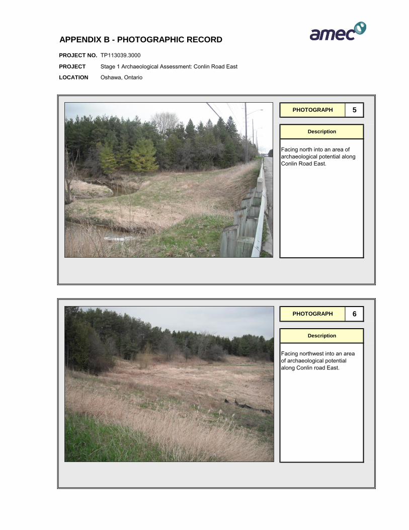
PROJECT NO.
PROJECT
LOCATION
APPENDIX B - PHOTOGRAPHIC RECORD
TP113039.3000
Stage 1 Archaeological Assessment: Conlin Road East
Oshawa, Ontario
PHOTOGRAPH 5
Description
Facing north into an area of archaeological potential along Conlin Road East.
PHOTOGRAPH 6
Description
Facing northwest into an area of archaeological potential along Conlin road East.

PROJECT NO.
PROJECT
LOCATION
APPENDIX B - PHOTOGRAPHIC RECORD
TP113039.3000
Stage 1 Archaeological Assessment: Conlin Road East
Oshawa, Ontario
PHOTOGRAPH 7
Description
Facing east along Conlin Road East. This area exhibits areas of low archaeological potential (slope and underground utitlities) and pocketed areas of archaeological potential.
PHOTOGRAPH 8
Description
Facing south into the large woodlot area along Conlin Road East. Area of archaeological potential.

PROJECT NO.
PROJECT
LOCATION
APPENDIX B - PHOTOGRAPHIC RECORD
TP113039.3000
Stage 1 Archaeological Assessment: Conlin Road East
Oshawa, Ontario
PHOTOGRAPH 9
Description
Facing east along Conlin Road East. This area exhibits areas of low archaeological potential and pocketed areas of archaeological potential. This space is owned by Scouts Canada access was limited.
PHOTOGRAPH 10
Description
Facing south into area owned by Scouts Canada, access to this area was limited, areas of low archaeological potenital within the existing right of way.
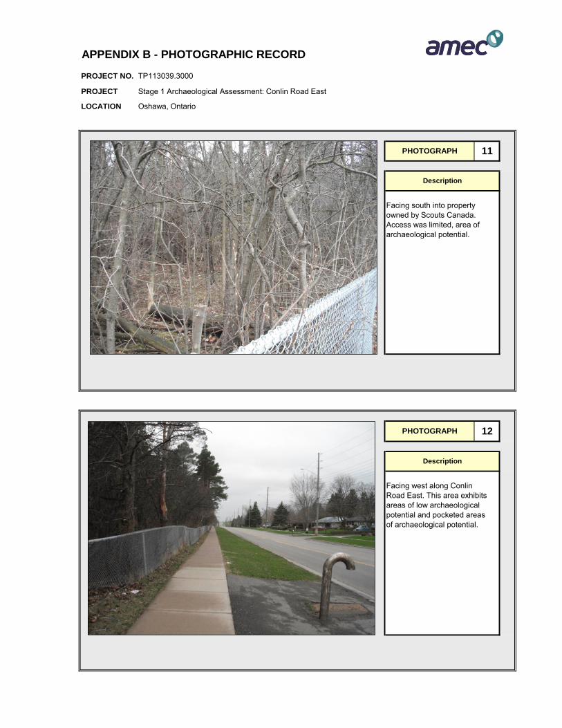
PROJECT NO.
PROJECT
LOCATION
APPENDIX B - PHOTOGRAPHIC RECORD
TP113039.3000
Stage 1 Archaeological Assessment: Conlin Road East
Oshawa, Ontario
PHOTOGRAPH 11
Description
Facing south into property owned by Scouts Canada. Access was limited, area of archaeological potential.
PHOTOGRAPH 12
Description
Facing west along Conlin Road East. This area exhibits areas of low archaeological potential and pocketed areas of archaeological potential.
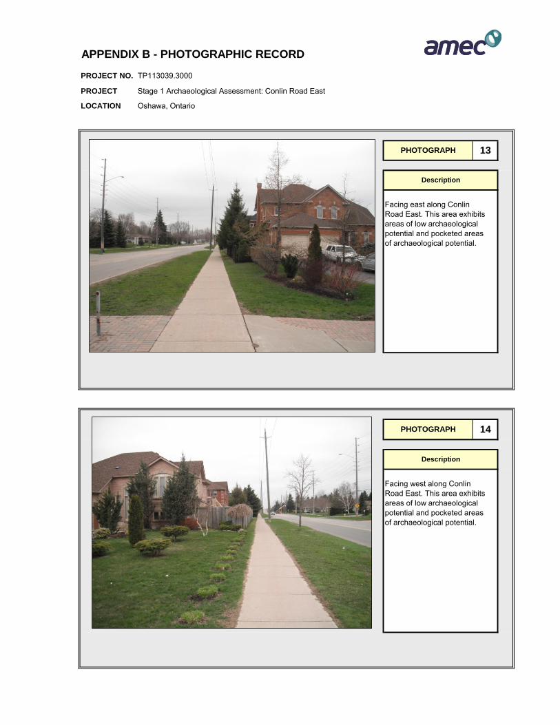
PROJECT NO.
PROJECT
LOCATION
APPENDIX B - PHOTOGRAPHIC RECORD
TP113039.3000
Stage 1 Archaeological Assessment: Conlin Road East
Oshawa, Ontario
PHOTOGRAPH 13
Description
Facing east along Conlin Road East. This area exhibits areas of low archaeological potential and pocketed areas of archaeological potential.
PHOTOGRAPH 14
Description
Facing west along Conlin Road East. This area exhibits areas of low archaeological potential and pocketed areas of archaeological potential.

PROJECT NO.
PROJECT
LOCATION
APPENDIX B - PHOTOGRAPHIC RECORD
TP113039.3000
Stage 1 Archaeological Assessment: Conlin Road East
Oshawa, Ontario
PHOTOGRAPH 15
Description
Facing east along Conlin Road East. This area exhibits areas of low archaeological potential and pocketed areas of archaeological potential.
PHOTOGRAPH 16
Description
Facing west along Conlin Road East. This area exhibits areas of low archaeological potential and pocketed areas of archaeological potential.
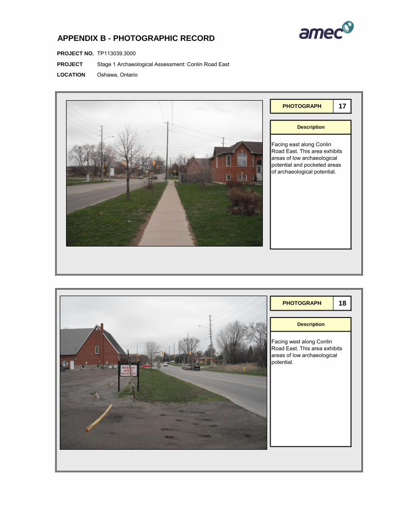
PROJECT NO.
PROJECT
LOCATION
APPENDIX B - PHOTOGRAPHIC RECORD
TP113039.3000
Stage 1 Archaeological Assessment: Conlin Road East
Oshawa, Ontario
PHOTOGRAPH 17
Description
Facing east along Conlin Road East. This area exhibits areas of low archaeological potential and pocketed areas of archaeological potential.
PHOTOGRAPH 18
Description
Facing west along Conlin Road East. This area exhibits areas of low archaeological potential.
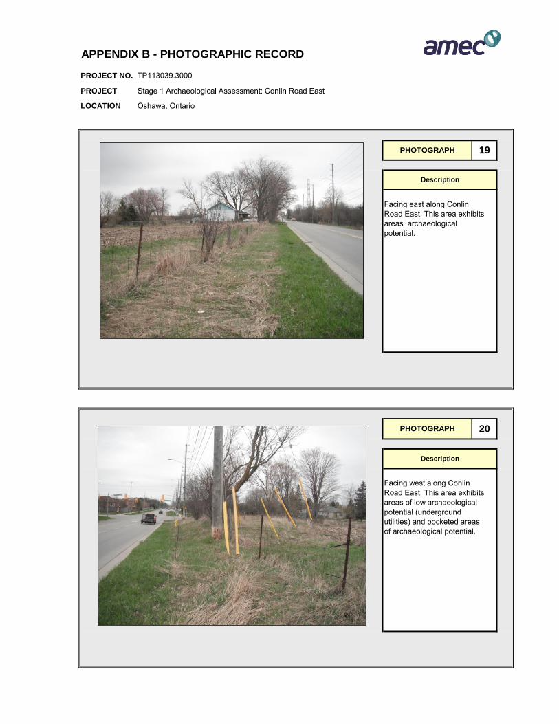
PROJECT NO.
PROJECT
LOCATION
APPENDIX B - PHOTOGRAPHIC RECORD
TP113039.3000
Stage 1 Archaeological Assessment: Conlin Road East
Oshawa, Ontario
PHOTOGRAPH 19
Description
Facing east along Conlin Road East. This area exhibits areas archaeological potential.
PHOTOGRAPH 20
Description
Facing west along Conlin Road East. This area exhibits areas of low archaeological potential (underground utilities) and pocketed areas of archaeological potential.
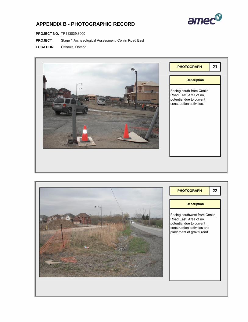
PROJECT NO.
PROJECT
LOCATION
APPENDIX B - PHOTOGRAPHIC RECORD
TP113039.3000
Stage 1 Archaeological Assessment: Conlin Road East
Oshawa, Ontario
PHOTOGRAPH 21
Description
Facing south from Conlin Road East. Area of no potential due to current construction activities.
PHOTOGRAPH 22
Description
Facing southwest from Conlin Road East. Area of no potential due to current construction activities and placement of gravel road.

PROJECT NO.
PROJECT
LOCATION
APPENDIX B - PHOTOGRAPHIC RECORD
TP113039.3000
Stage 1 Archaeological Assessment: Conlin Road East
Oshawa, Ontario
PHOTOGRAPH 23
Description
Facing south into new subdivision along Conlin Road East. Archaeological potential has been removed due to recent construction activities.
PHOTOGRAPH 24
Description
Facing southwest along Conlin Road East. Area of archaeological potential.

PROJECT NO.
PROJECT
LOCATION
APPENDIX B - PHOTOGRAPHIC RECORD
TP113039.3000
Stage 1 Archaeological Assessment: Conlin Road East
Oshawa, Ontario
PHOTOGRAPH 25
Description
Facing east along Conlin Road East. This area exhibits areas of low archaeological potential (gravel shoulder and underground utilities)and areas of archaeological potential.
PHOTOGRAPH 26
Description
Facing east along Conlin Road East. Area of archaeological potential.

PROJECT NO.
PROJECT
LOCATION
APPENDIX B - PHOTOGRAPHIC RECORD
TP113039.3000
Stage 1 Archaeological Assessment: Conlin Road East
Oshawa, Ontario
PHOTOGRAPH 27
Description
Facing west along Conlin Road East. Area of archaeological potential.
PHOTOGRAPH 28
Description
Facing west along Conlin Road East. Area of archaeological potential.

PROJECT NO.
PROJECT
LOCATION
APPENDIX B - PHOTOGRAPHIC RECORD
TP113039.3000
Stage 1 Archaeological Assessment: Conlin Road East
Oshawa, Ontario
PHOTOGRAPH 29
Description
Facing east along Conlin Road East. Area of archaeological potential excluding area of underground utilties.
PHOTOGRAPH 30
Description
Facing west along Conlin Road East. Archaeological potential removed due to underground utilities and low and wet areas.
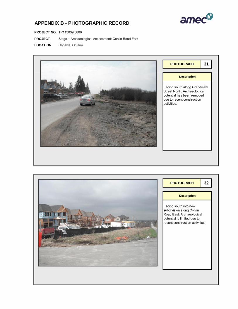
PROJECT NO.
PROJECT
LOCATION
APPENDIX B - PHOTOGRAPHIC RECORD
TP113039.3000
Stage 1 Archaeological Assessment: Conlin Road East
Oshawa, Ontario
PHOTOGRAPH 31
Description
Facing south along Grandview Street North. Archaeological potential has been removed due to recent construction activities.
PHOTOGRAPH 32
Description
Facing south into new subdivision along Conlin Road East. Archaeological potential is limited due to recent construction activities.

PROJECT NO.
PROJECT
LOCATION
APPENDIX B - PHOTOGRAPHIC RECORD
TP113039.3000
Stage 1 Archaeological Assessment: Conlin Road East
Oshawa, Ontario
PHOTOGRAPH 33
Description
Facing south into grassy area of archaeological potential.
PHOTOGRAPH 34
Description
Facing east along Conlin Road East. Area of archaeological potential excluding area of underground utilities.
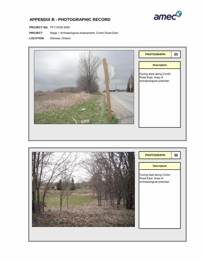
PROJECT NO.
PROJECT
LOCATION
APPENDIX B - PHOTOGRAPHIC RECORD
TP113039.3000
Stage 1 Archaeological Assessment: Conlin Road East
Oshawa, Ontario
PHOTOGRAPH 35
Description
Facing west along Conlin Road East. Area of archaeological potential.
PHOTOGRAPH 36
Description
Facing east along Conlin Road East. Area of archaeological potential.
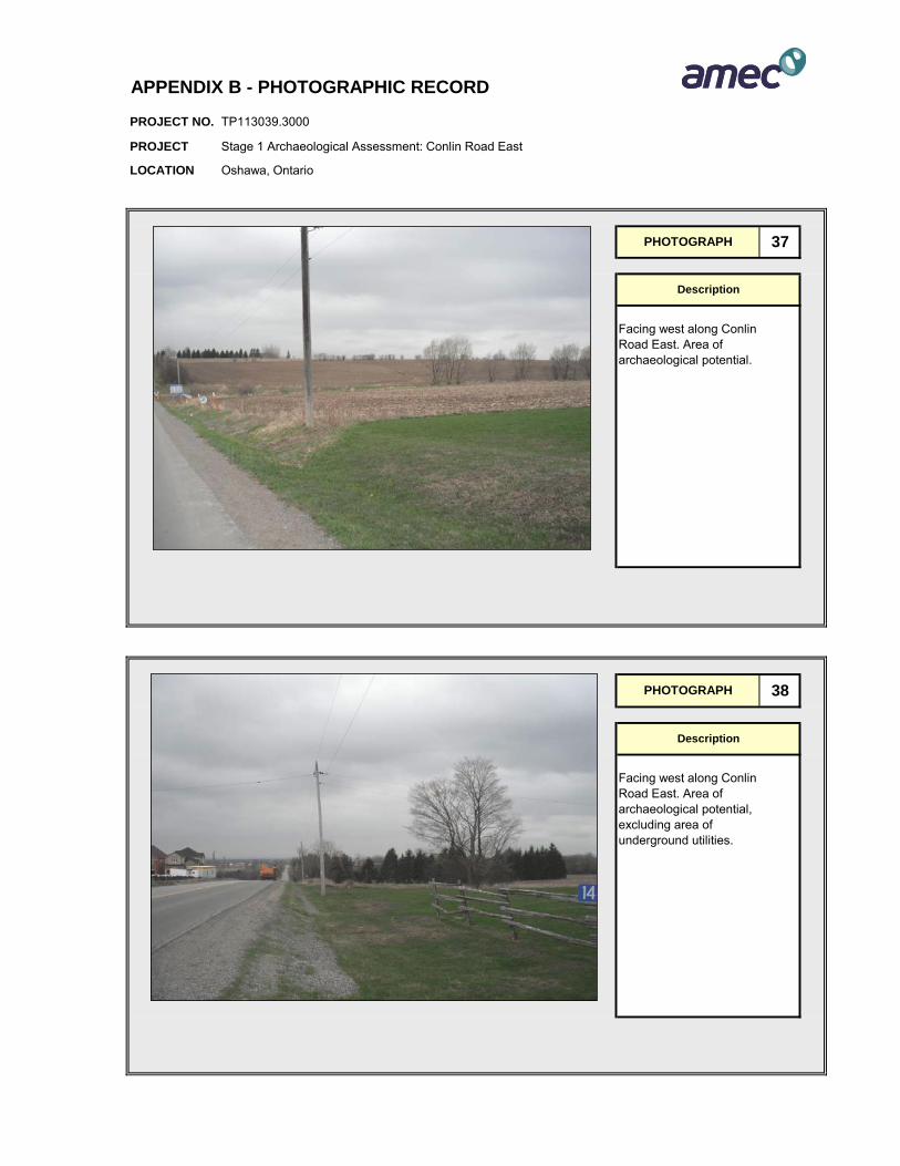
PROJECT NO.
PROJECT
LOCATION
APPENDIX B - PHOTOGRAPHIC RECORD
TP113039.3000
Stage 1 Archaeological Assessment: Conlin Road East
Oshawa, Ontario
PHOTOGRAPH 37
Description
Facing west along Conlin Road East. Area of archaeological potential.
PHOTOGRAPH 38
Description
Facing west along Conlin Road East. Area of archaeological potential, excluding area of underground utilities.
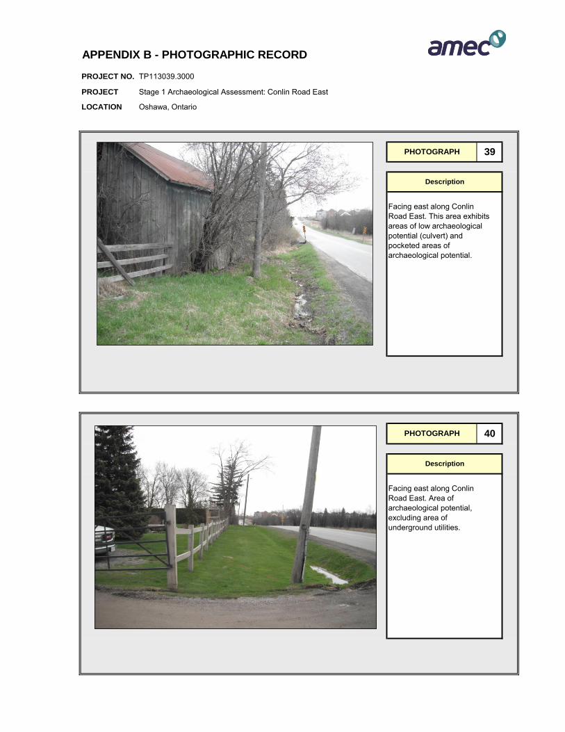
PROJECT NO.
PROJECT
LOCATION
APPENDIX B - PHOTOGRAPHIC RECORD
TP113039.3000
Stage 1 Archaeological Assessment: Conlin Road East
Oshawa, Ontario
PHOTOGRAPH 39
Description
Facing east along Conlin Road East. This area exhibits areas of low archaeological potential (culvert) and pocketed areas of archaeological potential.
PHOTOGRAPH 40
Description
Facing east along Conlin Road East. Area of archaeological potential, excluding area of underground utilities.
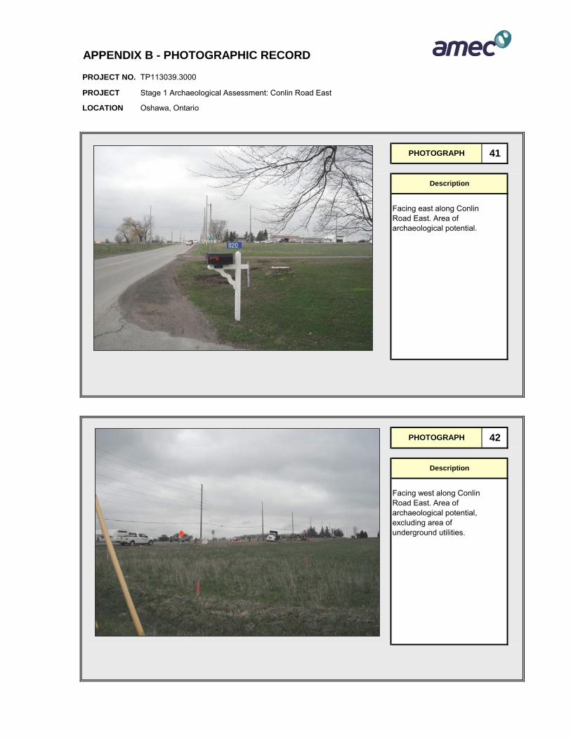
PROJECT NO.
PROJECT
LOCATION
APPENDIX B - PHOTOGRAPHIC RECORD
TP113039.3000
Stage 1 Archaeological Assessment: Conlin Road East
Oshawa, Ontario
PHOTOGRAPH 41
Description
Facing east along Conlin Road East. Area of archaeological potential.
PHOTOGRAPH 42
Description
Facing west along Conlin Road East. Area of archaeological potential, excluding area of underground utilities.

PROJECT NO.
PROJECT
LOCATION
APPENDIX B - PHOTOGRAPHIC RECORD
TP113039.3000
Stage 1 Archaeological Assessment: Conlin Road East
Oshawa, Ontario
PHOTOGRAPH 43
Description
Facing west along Conlin Road East. Area of archaeological potential, excluding area of underground utilities.
PHOTOGRAPH 44
Description
Facing east along Conlin Road East. Area of archaeological potential, excluding area of underground utilities.
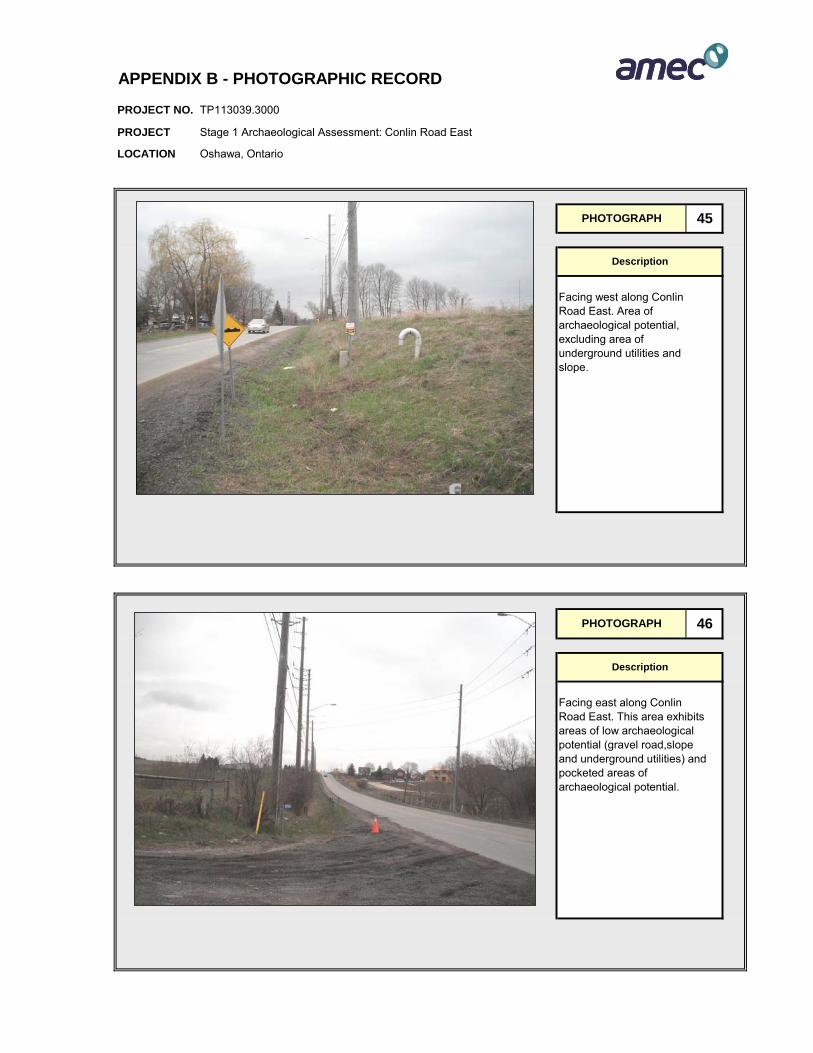
PROJECT NO.
PROJECT
LOCATION
APPENDIX B - PHOTOGRAPHIC RECORD
TP113039.3000
Stage 1 Archaeological Assessment: Conlin Road East
Oshawa, Ontario
PHOTOGRAPH 45
Description
Facing west along Conlin Road East. Area of archaeological potential, excluding area of underground utilities and slope.
PHOTOGRAPH 46
Description
Facing east along Conlin Road East. This area exhibits areas of low archaeological potential (gravel road,slope and underground utilities) and pocketed areas of archaeological potential.
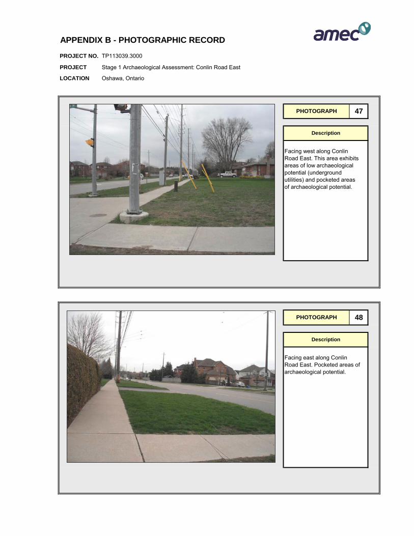
PROJECT NO.
PROJECT
LOCATION
APPENDIX B - PHOTOGRAPHIC RECORD
TP113039.3000
Stage 1 Archaeological Assessment: Conlin Road East
Oshawa, Ontario
PHOTOGRAPH 47
Description
Facing west along Conlin Road East. This area exhibits areas of low archaeological potential (underground utilities) and pocketed areas of archaeological potential.
PHOTOGRAPH 48
Description
Facing east along Conlin Road East. Pocketed areas of archaeological potential.
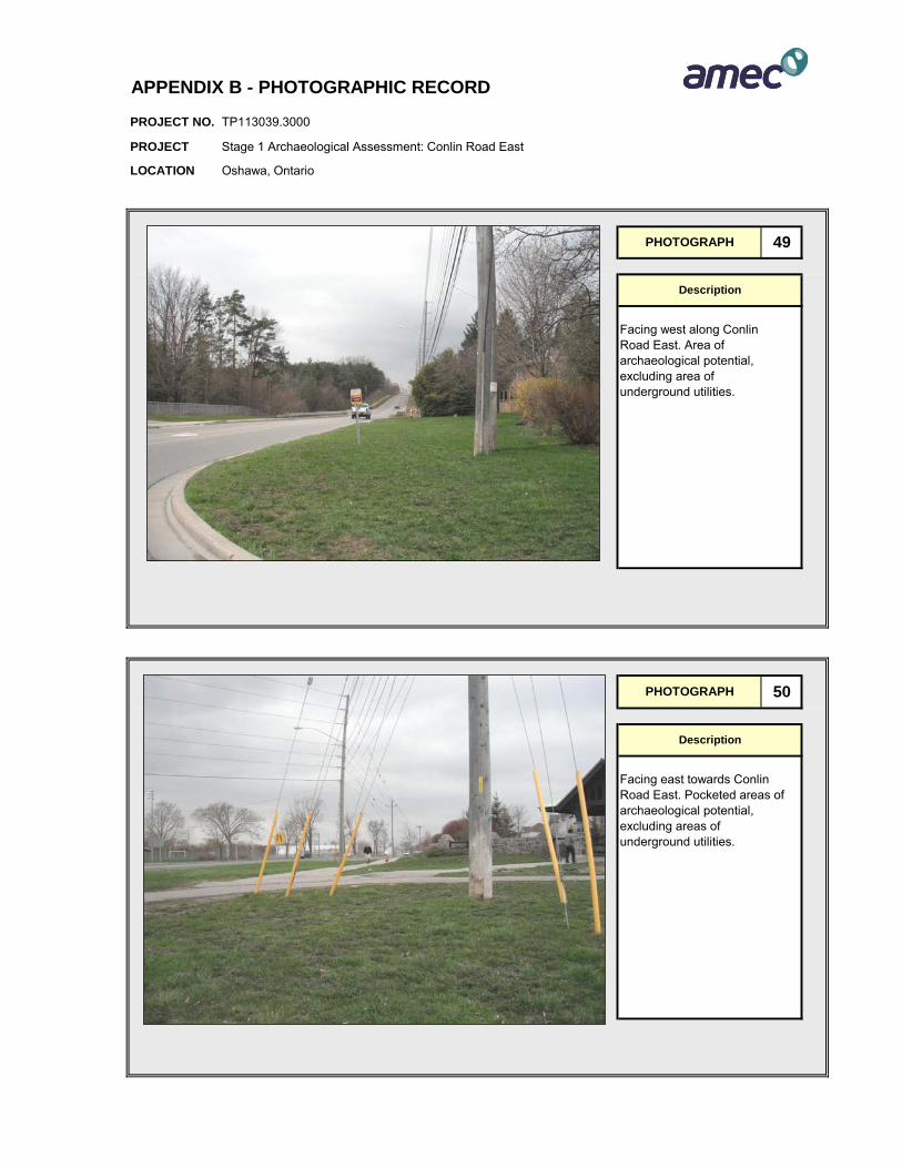
PROJECT NO.
PROJECT
LOCATION
APPENDIX B - PHOTOGRAPHIC RECORD
TP113039.3000
Stage 1 Archaeological Assessment: Conlin Road East
Oshawa, Ontario
PHOTOGRAPH 49
Description
Facing west along Conlin Road East. Area of archaeological potential, excluding area of underground utilities.
PHOTOGRAPH 50
Description
Facing east towards Conlin Road East. Pocketed areas of archaeological potential, excluding areas of underground utilities.
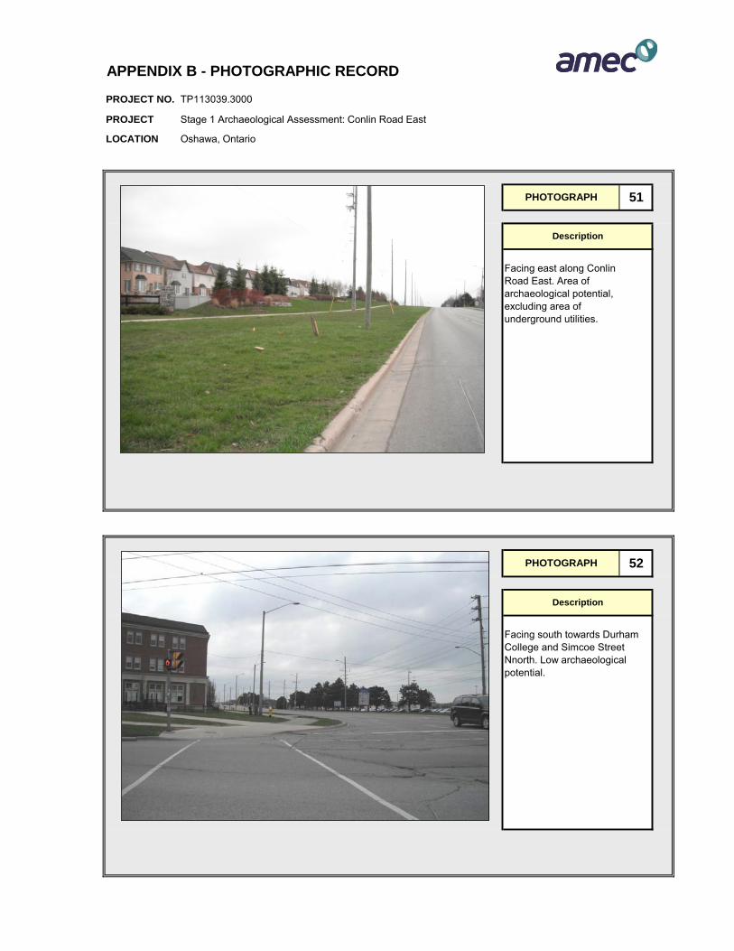
PROJECT NO.
PROJECT
LOCATION
APPENDIX B - PHOTOGRAPHIC RECORD
TP113039.3000
Stage 1 Archaeological Assessment: Conlin Road East
Oshawa, Ontario
PHOTOGRAPH 51
Description
Facing east along Conlin Road East. Area of archaeological potential, excluding area of underground utilities.
PHOTOGRAPH 52
Description
Facing south towards Durham College and Simcoe Street Nnorth. Low archaeological potential.
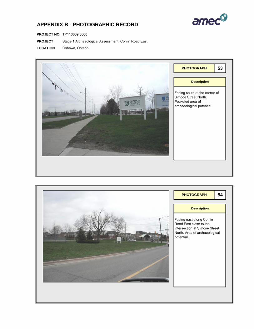
PROJECT NO.
PROJECT
LOCATION
APPENDIX B - PHOTOGRAPHIC RECORD
TP113039.3000
Stage 1 Archaeological Assessment: Conlin Road East
Oshawa, Ontario
PHOTOGRAPH 53
Description
Facing south at the corner of Simcoe Street North. Pocketed area of archaeological potential.
PHOTOGRAPH 54
Description
Facing east along Conlin Road East close to the intersection at Simcoe Street North. Area of archaeological potential.

Stage 1 Background Study and Property InspectionConlin Road East from Simcoe Street North to east City Limit.City of Oshawa, Ontario.
Project Number TP113039 Appendix C
APPENDIX C
QUALIFICATIONS OF THE ASSESSORS

ASSESSOR QUALIFICATIONS
Dr. Shaun Austin, Ph.D. – Associate Archaeologist
Dr. Austin is the Group Leader of AMEC’s archaeology group and is based in the AMEC Hamilton O ffice. H e has been working i n C anadian A rchaeology si nce 1976 and has over 23 y ears of a rchaeological co nsulting ex perience i n S outhern Ontario. H e i s a dedicated cu ltural he ritage co nsultant w ith r epeated su ccess guiding archaeological projects through t o co mpletion t o the satisfaction o f the dev elopment p roponent, t he cultural heritage community and all other stakeholder groups. Dr. Austin currently holds a pr ofessional ar chaeology l icense ( License P 141) i ssued by t he O ntario M inistry o f Tourism and Culture, is a member of the Association of Professional Archaeologists and is MTO RAQS accredited.
Jason Seguin, M.A. – Staff Archaeologist
Mr. Seguin is an archaeologist with a combination of 9 years experience in the archaeological industry. In the archaeological field Mr. Seguin as conducted stage 1 to 4 archaeological asse ssments including ba ckground se arches, field su rveys, archaeological excavations, analysis of cultural artifacts, laboratory work and reporting. Mr. Seguin has also been involved in various aspects of project management and supervision as well as being an archaeological laboratory director. Mr. Seguin has developed research and communication skills through editing field reports, teaching university level students in both lecture and seminar environments, as well as preparing and pr esenting pr esentations at aca demic conferences. M r. S eguin’s education and work experience have provided him with an extensive knowledge base, consisting of theoretical and practical experience in cultural resource management in Canada and Central America, as well as curatorial, archival and museum management experience. Mr. Seguin holds a Master’s Degree in Anthropology from Trent University, a Bachelors of A rt H onours degree in A nthropology from Trent U niversity, and a Post-Graduate Certificate in Museum Management and Curatorship from Sir Sandford Fleming College. Mr. Seguin currently holds a professional archaeology license (License P354) issued by the Ontario Ministry of Tourism and Culture.
Cara Howell, B.A. – Staff Archaeologist
Ms. H owell i s an ar chaeologist w ith ov er 10 years of ex perience i n t he ar chaeology industry. During this time she has acquired a full range of archaeological skills and has developed an expert understanding of historic Euro-Canadian artifacts. As a laboratory director, he r du ties included t he dev elopment and i mplementation o f a co mputerized artifact ca taloguing sy stem for hi storic artifacts of l ate ei ghteenth t o twentieth ce ntury resources. She has completed historic research from literature review to archival documentation t hrough designing and i mplementing de tailed hi storic artifact anal ysis. Ms. H owell hol ds a D egree i n A nthropology from M cMaster U niversity and cu rrently serves as the Laboratory Director for AMEC’s Archaeology Group. Ms. Howell currently holds a r esearch ar chaeology l icense ( License R18) i ssued by the O ntario Ministry of Tourism and Culture.
Stage 1 Background Study and Property InspectionConlin Road East from Simcoe Street North to east City Limit.City of Oshawa, Ontario.
Project Number TP113039 Appendix D
APPENDIX D
LIMITATIONS

Stage 1 Background Study and Property Inspection Conlin Road East from Simcoe Street North to east City Limit City of Oshawa, Ontario
Project Number TP113039
LIMITATIONS 1. The work performed in the preparation of this report and the conclusions presented are
subject to the following:
(a) The Standard Terms and Conditions which form a part of our Professional Services Contract;
(b) The Scope of Services; (c) Time and Budgetary limitations as described in our Contract; and, (d) The Limitations stated herein.
2. No other warranties or representations, either expressed or implied, are made as to the professional services provided under the terms of our Contract, or the conclusions presented.
3. The conclusions presented in this report were based, in par t, on visual observations of the Study Area. Our conclusions cannot and are not extended to include those portions of the Study A rea w hich w ere not reasonably available, i n A MEC’s op inion, f or di rect observation.
4. The pot ential f or ar chaeological r esources, and an y ac tual ar chaeological r esources encountered, at the S tudy A rea were assessed, within the l imitations s et out abo ve, having due regard for applicable heritage regulations as of the date of the inspection.
5. Services i ncluding a background s tudy and site visits w ere performed. A MEC’s work, including archival studies and a site visit were conducted in a professional manner and in accordance with the Ministry of T ourism and C ulture’s guidelines. I t is pos sible t hat unforeseen a nd un discovered ar chaeological r esources may be pr esent at t he S tudy Area.
6. The ut ilization of A MEC’s s ervices dur ing t he i mplementation of an y f urther archaeological work recommended w ill al low AMEC t o obs erve compliance w ith t he conclusions and recommendations contained in the report. AMEC’s involvement will also allow f or c hanges t o be made as nec essary t o s uit f ield c onditions as t hey ar e encountered.
7. This r eport i s for t he s ole us e of t he par ties t o w hom i t is addr essed unl ess e xpressly stated otherwise in the report or contract. A ny use which an y third par ty m akes of the report, i n whole or i n p art, or an y r eliance t hereon, or dec isions made bas ed on an y information of c onclusions i n t he r eport, is t he s ole r esponsibility of s uch t hird par ty. AMEC ac cepts n o r esponsibility whatsoever f or dam ages or l oss of an y nat ure or k ind suffered b y any s uch t hird par ty as a r esult of ac tions t aken or not taken or d ecisions made in reliance on the report or anything set out therein.
8. This report is not to be given over to any third-party other than a governmental entity, for any purpose whatsoever without the written permission of AMEC, which shall not be unreasonably withheld.

1
City Manager Approval
Third-Party Source
January 11, 2017
The City of Oshawa is committed to creating an accessible online experience by making web content available to everyone. The City makes it a priority to provide website documents in an accessible format, however the attached document is not accessible as the City is not the author of the document. If this information is required in an accessible format, please contact Service Oshawa; Telephone: 905-436-3311, or email: [email protected] or in person at City Hall, 50 Centre Street South, Oshawa.