Embed Size (px)
Citation preview
Overview of the Joint Center for Satellite Data Assimilation
(JCSDA)
Presented by
Sid-Ahmed Boukabara, Deputy Director
CICS Science Meeting September 8-9, 2010 1
Outline
JCSDA Structure JCSDA Vision, mission, priorities, goals Mode of Operation & Science Implementation; Examples of JCSDA Achievements Outreach Activities JCSDA and CICS (Current and Future plans)
CICS Science Meeting September 8-9, 2010
JCSDA Structure
3CICS Science Meeting September 8-9, 2010
4
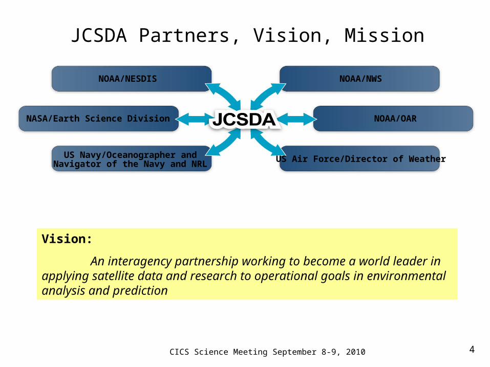
NASA/Earth Science Division
US Navy/Oceanographer andNavigator of the Navy and NRL
NOAA/NESDIS NOAA/NWS
NOAA/OAR
US Air Force/Director of Weather
Vision:
An interagency partnership working to become a world leader in applying satellite data and research to operational goals in environmental analysis and prediction
JCSDA Partners, Vision, Mission
CICS Science Meeting September 8-9, 2010
5
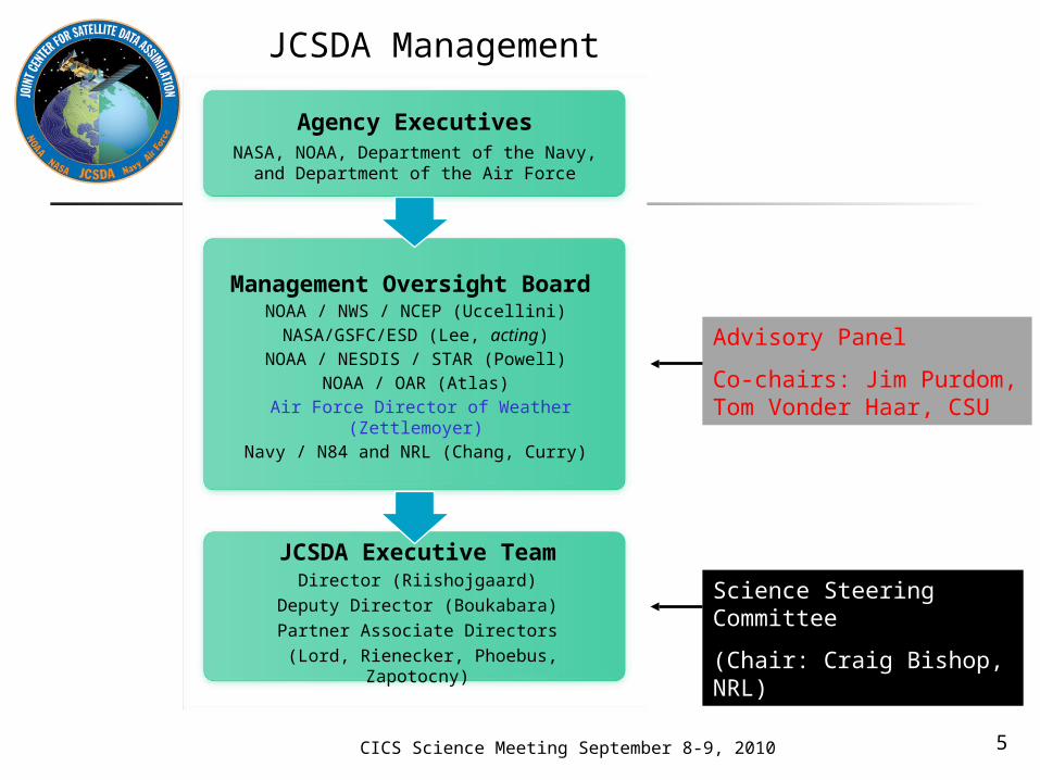
JCSDA Executive TeamDirector (Riishojgaard)
Deputy Director (Boukabara)
Partner Associate Directors
(Lord, Rienecker, Phoebus, Zapotocny)
Management Oversight Board
NOAA / NWS / NCEP (Uccellini)NASA/GSFC/ESD (Lee, acting)
NOAA / NESDIS / STAR (Powell)NOAA / OAR (Atlas)
Air Force Director of Weather (Zettlemoyer)Navy / N84 and NRL (Chang, Curry)
Agency ExecutivesNASA, NOAA, Department of the Navy, and
Department of the Air Force
Advisory Panel
Co-chairs: Jim Purdom, Tom Vonder Haar, CSU
Science Steering Committee
(Chair: Craig Bishop, NRL)
JCSDA Management
CICS Science Meeting September 8-9, 2010
JCSDA MISSION, PRIORITIES, GOALS
6CICS Science Meeting September 8-9, 2010
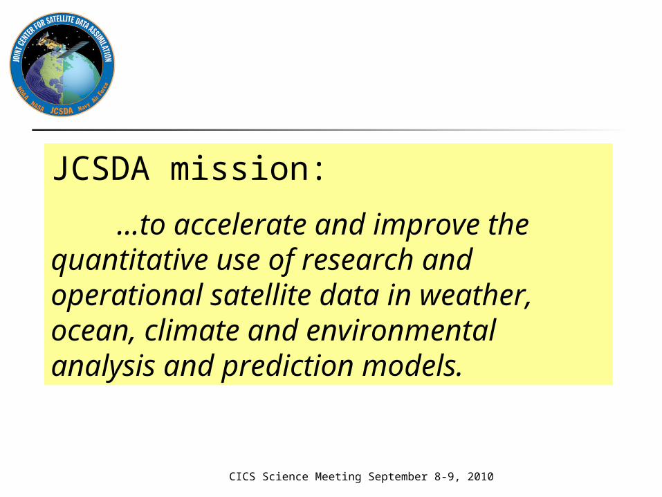
JCSDA mission:
…to accelerate and improve the quantitative use of research and operational satellite data in weather, ocean, climate and environmental analysis and prediction models.
CICS Science Meeting September 8-9, 2010
JCSDA short-term goal:(adopted 03/2008)
“Contribute to making the forecast skill of the operational NWP systems of the JCSDA partners internationally competitive by assimilating the largest possible number of satellite observations in the most effective way”
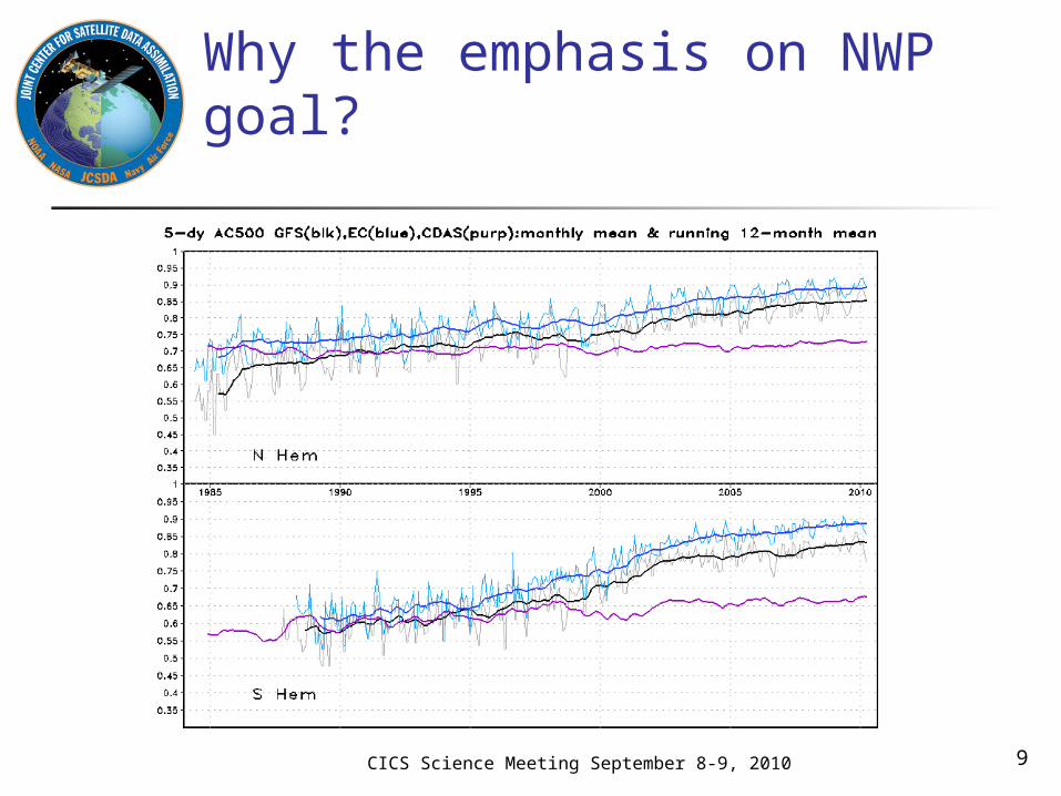
Why the emphasis on NWP goal?
9CICS Science Meeting September 8-9, 2010
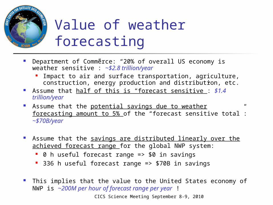
Value of weather forecasting Department of Commerce: “20% of overall US economy is
weather sensitive”: ~$2.8 trillion/year Impact to air and surface transportation, agriculture,
construction, energy production and distribution, etc. Assume that half of this is “forecast sensitive”: $1.4 trillion/year Assume that the potential savings due to weather forecasting
amount to 5% of the “forecast sensitive total”: ~$70B/year
Assume that the savings are distributed linearly over the achieved forecast range for the global NWP system:
0 h useful forecast range => $0 in savings 336 h useful forecast range => $70B in savings
This implies that the value to the United States economy of NWP is ~200M per hour of forecast range per year !
CICS Science Meeting September 8-9, 2010
11
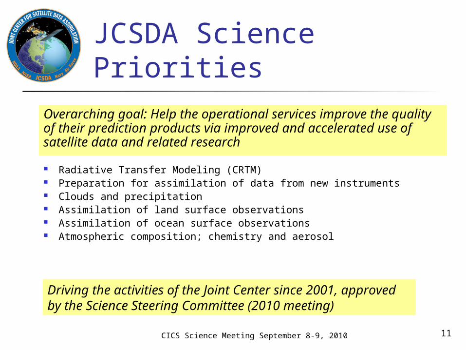
JCSDA Science Priorities
Radiative Transfer Modeling (CRTM) Preparation for assimilation of data from new instruments Clouds and precipitation Assimilation of land surface observations Assimilation of ocean surface observations Atmospheric composition; chemistry and aerosol
Driving the activities of the Joint Center since 2001, approved by the Science Steering Committee (2010 meeting)
Overarching goal: Help the operational services improve the quality of their prediction products via improved and accelerated use of satellite data and related research
CICS Science Meeting September 8-9, 2010
JCSDA’S MODES OF OPERATION & SCIENCE IMPLEMENTATION
12CICS Science Meeting September 8-9, 2010

JCSDA Modes of Operation
Directed research Carried out by the partners Mixture of new and leveraged funding JCSDA plays a coordinating role
External research Grants awarded following proposals submitted to Federal Funding
Opportunity, administered by NOAA on behalf of all JCSDA partners
Option for contracts will be added for FY2011 Open to the broader research community Funding awarded competitively, peer review process
Visiting Scientist Program (short-term and medium-term visits) Cooperative Institutes Have/Can Participate in all Modes JCSDA organizes an annual workshop to coordinate
all these efforts and encourage collaborations
13
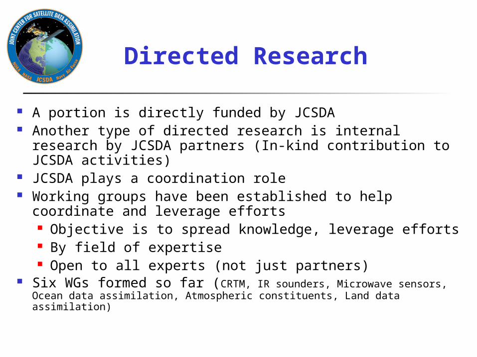
Directed Research
A portion is directly funded by JCSDA Another type of directed research is internal research by
JCSDA partners (In-kind contribution to JCSDA activities) JCSDA plays a coordination role Working groups have been established to help
coordinate and leverage efforts Objective is to spread knowledge, leverage efforts By field of expertise Open to all experts (not just partners)
Six WGs formed so far (CRTM, IR sounders, Microwave sensors, Ocean data assimilation, Atmospheric constituents, Land data assimilation)
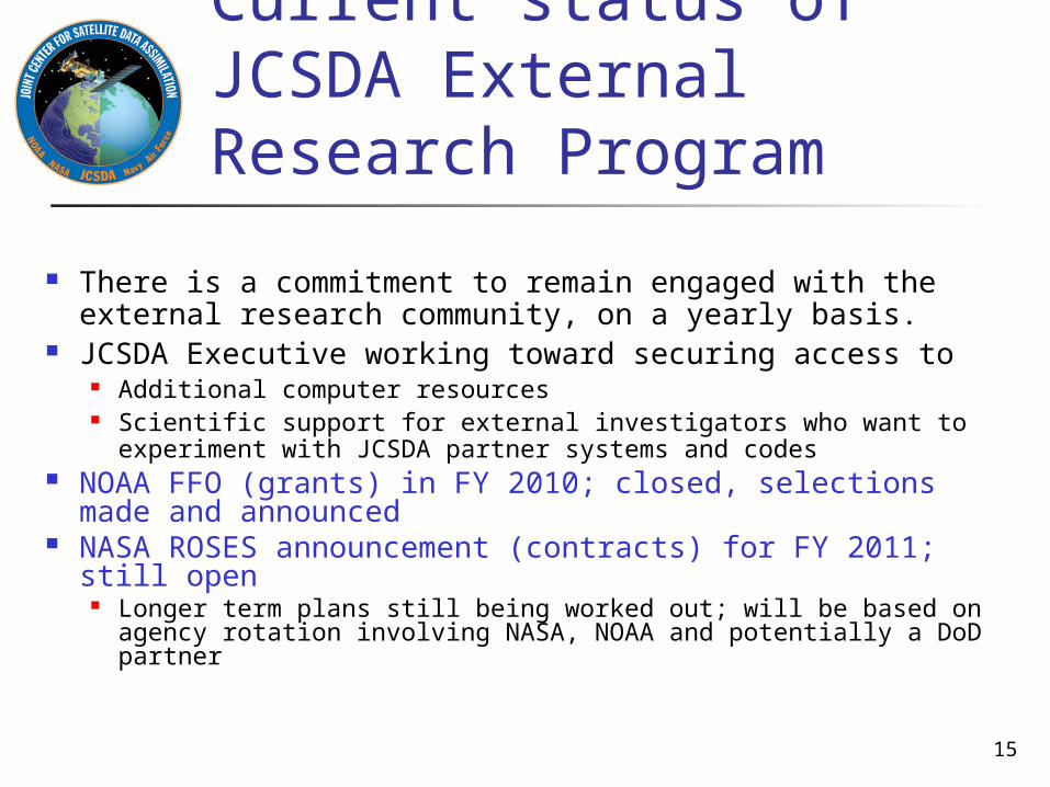
Current status of JCSDA External Research Program
There is a commitment to remain engaged with the external research community, on a yearly basis.
JCSDA Executive working toward securing access to Additional computer resources Scientific support for external investigators who want to
experiment with JCSDA partner systems and codes NOAA FFO (grants) in FY 2010; closed, selections made
and announced NASA ROSES announcement (contracts) for FY 2011; still
open Longer term plans still being worked out; will be based on agency
rotation involving NASA, NOAA and potentially a DoD partner
15
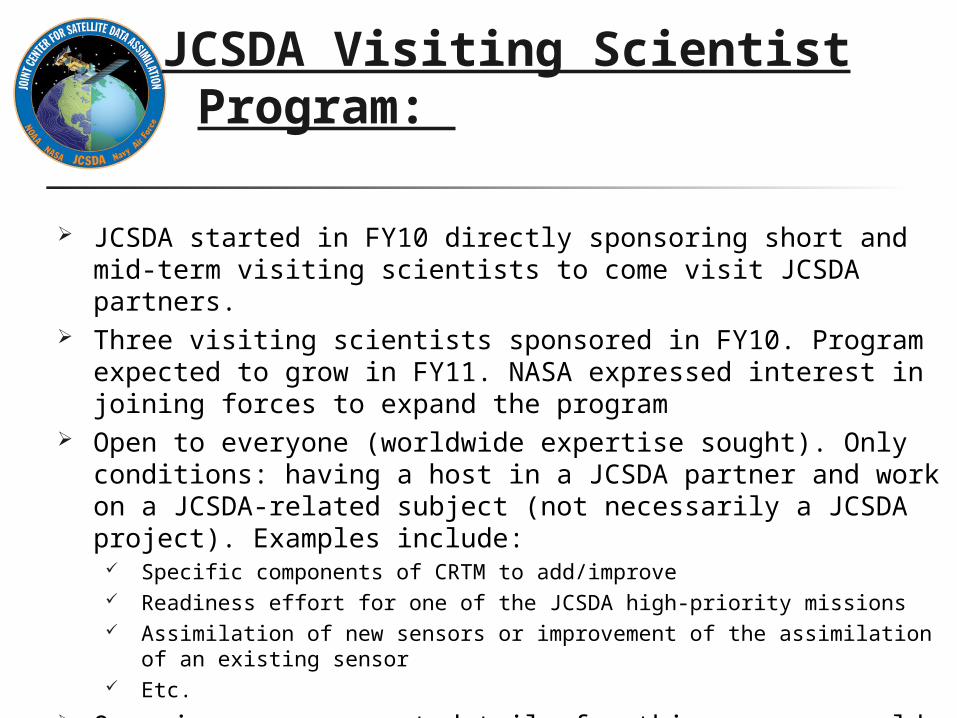
JCSDA Visiting Scientist Program:
JCSDA started in FY10 directly sponsoring short and mid-term visiting scientists to come visit JCSDA partners.
Three visiting scientists sponsored in FY10. Program expected to grow in FY11. NASA expressed interest in joining forces to expand the program
Open to everyone (worldwide expertise sought). Only conditions: having a host in a JCSDA partner and work on a JCSDA-related subject (not necessarily a JCSDA project). Examples include:
Specific components of CRTM to add/improve Readiness effort for one of the JCSDA high-priority missions Assimilation of new sensors or improvement of the assimilation of an existing sensor Etc.
On-going announcement details for this program could be found in the JCSDA web site.
EXAMPLES OF JCSDA ACTIVITIES
17CICS Science Meeting September 8-9, 2010
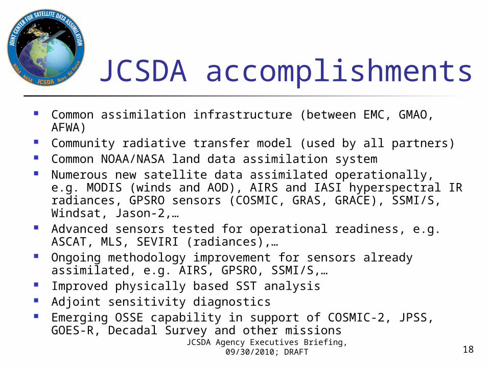
JCSDA Agency Executives Briefing, 09/30/2010; DRAFT
JCSDA accomplishments Common assimilation infrastructure (between EMC, GMAO, AFWA) Community radiative transfer model (used by all partners) Common NOAA/NASA land data assimilation system Numerous new satellite data assimilated operationally, e.g. MODIS
(winds and AOD), AIRS and IASI hyperspectral IR radiances, GPSRO sensors (COSMIC, GRAS, GRACE), SSMI/S, Windsat, Jason-2,…
Advanced sensors tested for operational readiness, e.g. ASCAT, MLS, SEVIRI (radiances),…
Ongoing methodology improvement for sensors already assimilated, e.g. AIRS, GPSRO, SSMI/S,…
Improved physically based SST analysis Adjoint sensitivity diagnostics Emerging OSSE capability in support of COSMIC-2, JPSS, GOES-R,
Decadal Survey and other missions
18
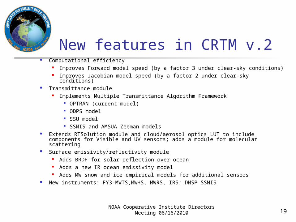
New features in CRTM v.2 Computational efficiency
Improves Forward model speed (by a factor 3 under clear-sky conditions) Improves Jacobian model speed (by a factor 2 under clear-sky conditions)
Transmittance module Implements Multiple Transmittance Algorithm Framework
OPTRAN (current model) ODPS model SSU model SSMIS and AMSUA Zeeman models
Extends RTSolution module and cloud/aerosol optics LUT to include components for Visible and UV sensors; adds a module for molecular scattering
Surface emissivity/reflectivity module Adds BRDF for solar reflection over ocean Adds a new IR ocean emissivity model Adds MW snow and ice empirical models for additional sensors
New instruments: FY3-MWTS,MWHS, MWRS, IRS; DMSP SSMIS
19NOAA Cooperative Institute Directors Meeting
06/16/2010
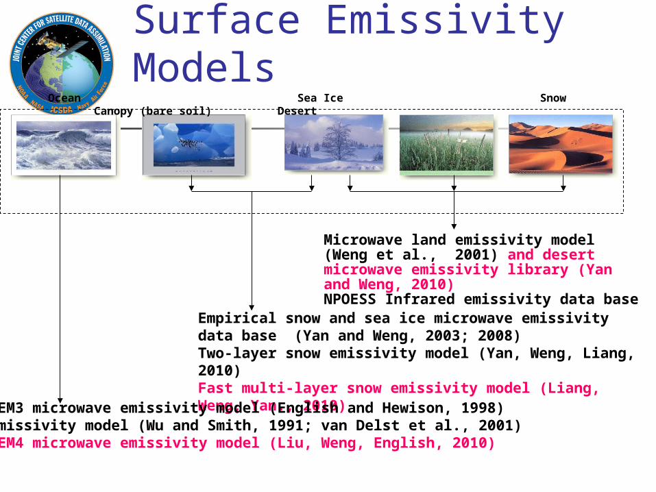
Surface Emissivity Models
Microwave land emissivity model (Weng et al., 2001) and desert microwave emissivity library (Yan and Weng, 2010) NPOESS Infrared emissivity data base
Ocean Sea Ice Snow Canopy (bare soil) Desert
Empirical snow and sea ice microwave emissivity data base (Yan and Weng, 2003; 2008)Two-layer snow emissivity model (Yan, Weng, Liang, 2010)Fast multi-layer snow emissivity model (Liang, Weng, Yan., 2010)
FASTEM3 microwave emissivity model (English and Hewison, 1998)IR emissivity model (Wu and Smith, 1991; van Delst et al., 2001)FASTEM4 microwave emissivity model (Liu, Weng, English, 2010)
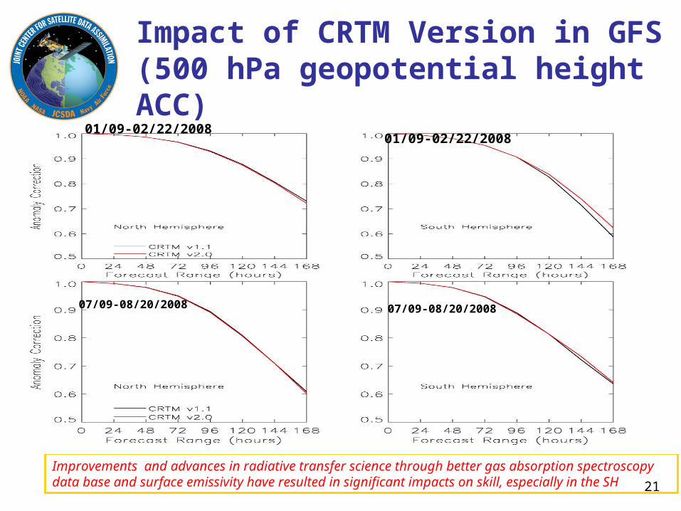
Improvements and advances in radiative transfer science through better gas absorption spectroscopy data base and surface emissivity have resulted in significant impacts on skill, especially in the SH
01/09-02/22/200801/09-02/22/2008
07/09-08/20/2008 07/09-08/20/2008
Impact of CRTM Version in GFS (500 hPa geopotential height ACC)
21
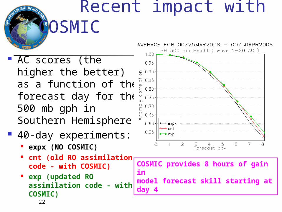
Recent impact with COSMIC
AC scores (the higher the better) as a function of the forecast day for the 500 mb gph in Southern Hemisphere
40-day experiments: expx (NO COSMIC) cnt (old RO assimilation
code - with COSMIC) exp (updated RO
assimilation code - with COSMIC)
COSMIC provides 8 hours of gain in model forecast skill starting at day 4
22
What to expect in FY11
External research through NASA Roses 2010 Internal Research (JSDI) -open for NOAA and CIs scientists- Expansion of the Visiting Scientist Program Data Assimilation Computing Capability for STAR and JCSDA
Scientists to run Operational Models More JCSDA Software packages made available to users Spring JCSDA Science workshop Summer Colloquium on Satellite Data Assimilation for graduate
students Joint JCSDA/HFIP Workshop on satellite data assimilation for
hurricane prediction Data assimilation position at UMD, co-sponsored by JCSDA JCSDA Role in JPSS: bridge between NESDIS and NWP users. To
ensure readiness and a transition to assimilating JPSS data
JCSDA & CICS
24CICS Science Meeting September 8-9, 2010
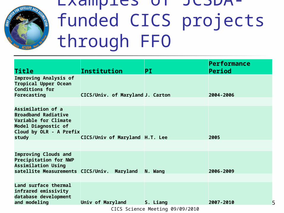
Examples of JCSDA-funded CICS projects through FFO
CICS Science Meeting 09/09/201025
Title Institution PI Performance PeriodImproving Analysis of Tropical Upper Ocean Conditions for Forecasting CICS/Univ. of Maryland J. Carton 2004-2006
Assimilation of a Broadband Radiative Variable for Climate Model Diagnostic of Cloud by OLR - A Prefix study CICS/Univ of Maryland H.T. Lee 2005
Improving Clouds and Precipitation for NWP Assimilation Using satellite Measurements CICS/Univ. Maryland N. Wang 2006-2009
Land surface thermal infrared emissivity database development and modeling Univ of Maryland S. Liang 2007-2010
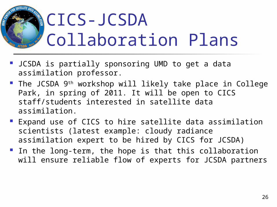
CICS-JCSDA Collaboration Plans
JCSDA is partially sponsoring UMD to get a data assimilation professor.
The JCSDA 9th workshop will likely take place in College Park, in spring of 2011. It will be open to CICS staff/students interested in satellite data assimilation.
Expand use of CICS to hire satellite data assimilation scientists (latest example: cloudy radiance assimilation expert to be hired by CICS for JCSDA)
In the long-term, the hope is that this collaboration will ensure reliable flow of experts for JCSDA partners
26
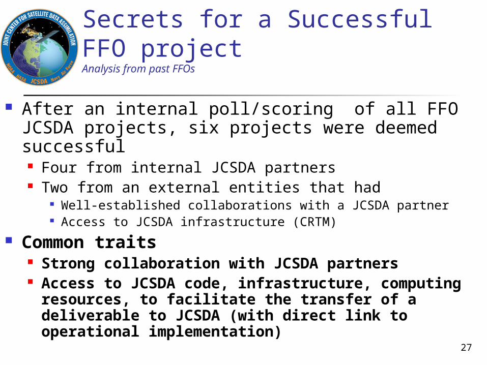
Secrets for a Successful FFO projectAnalysis from past FFOs
After an internal poll/scoring of all FFO JCSDA projects, six projects were deemed successful Four from internal JCSDA partners Two from an external entities that had
Well-established collaborations with a JCSDA partner Access to JCSDA infrastructure (CRTM)
Common traits Strong collaboration with JCSDA partners Access to JCSDA code, infrastructure,
computing resources, to facilitate the transfer of a deliverable to JCSDA (with direct link to operational implementation)
27
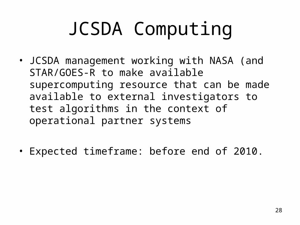
JCSDA Computing
• JCSDA management working with NASA (and STAR/GOES-R to make available supercomputing resource that can be made available to external investigators to test algorithms in the context of operational partner systems
• Expected timeframe: before end of 2010.
28
Secrets for a Successful JSDI project(NOAA’s JCSDA Internal project)
Project must aim at having a direct deliverable to an operational code/tool. Added advantage if tool could be used by more than 1 partner (ex: CRTM)
Strong collaboration with a NOAA PI to ensure link to operations (both STAR and NCEP)
The clear identification of a path leading from the research setting to the operational setting where a specific gap in the operational implementation was identified.
It could either be a science shortcoming or the absence of a promising sensor in the operational assimilation system (especially if it has been shown by other centers that its impact is significant).
Proposals will benefit from combining improving data assimilation
science with operationally assimilating actual sensors data.
29
Outreach activities
30
- JCSDA Monthly Seminars - Summer Data Assimilation Colloquium- Quarterly newsletter- Annual JCSDA Science Workshop- Organization of national and international joint Workshops- Etc
JCSDA Seminars
Typically one to two seminars per month in WWB, open to everyone.
Good mix of national and international speakers on wide variety of satellite and data assimilation related topics
Generally well attended, both in person and virtually (Webex and phone-in)
31
JCSDA Summer Colloquium
Two-week summer school in Stevenson, WA, 07/07-07/17, 2009
Outstanding program of lectures given by world-renowned experts
38 participants (almost all Ph.D. students or post-docs) from 8 countries, including the US
Sponsored by all JCSDA partners Based on feedback from lecturers and participants
it was a highly successful event JCSDA plans to stay engaged in training in the
future; form yet to be decided Next colloquium planned for summer 2011
32
JCSDA Science Workshop
Aims at encouraging collaboration/coordination among partners and with external research community
Aims also at gathering feedback from scientists on future directions JCSDA should consider.
8th Workshop Conducted May 4-5, 2010 in University of Maryland, BC
Reports from: JCSDA management Five of six JCSDA Working Groups Funded JSDI and FFO investigators In-kind contributors (i.e. Partner Agencies)
33
National and International Joint Workshops
Joint ECMWF-JCSDA Workshop on Assimilation of Clouds and Precipitation Observations in Reading, took place June 15-17
First joint event between ECMWF and JCSDA Joint program committee, ECMWF funded most European
participants, JCSDA funded most US participants Key science priority area for both organizations identified
Planned: Joint JCSDA-HFIP workshop to deal with data
assimilation in the context of Hurricane forecast
34
Summary:Where to get More Information?
• JCSDA Web site will include more info about:– More description of the JCSDA activities/research areas of
interest– Current Research Opportunities – Past and current newsletters– Seminar announcements– JCSDA-relevant career opportunities– Details about the visiting scientist program– List of past and currently funded projects – List of JCSDA-funded projects publications– Etc.
• http://www.jcsda.noaa.gov35