Embed Size (px)
Citation preview

Overview on Albanian Reference Systems,actual situation and the future challenge
Prepared by:Prof. Asoc. Eduard
IsufiProf. Asoc. Qemal
SkukaDr. Eng. Gezim
GjataMsc. Ing. Bilbil
Nurçe
Polytechnic University of Tirana Department of Geodesy
Tirana -
Albania
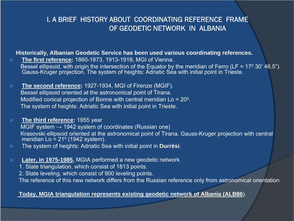
I. A BRIEF HISTORY ABOUT COORDINATING REFERENCE FRAME
OF GEODETIC NETWORK IN ALBANIA
Historically, Albanian Geodetic Service has been used various coordinating references.The first reference: 1860-1873, 1913-1918, MGI of Vienna. Bessel ellipsoid, with origin the intersection of the Equator by the meridian of Ferro (LF = 170
30’
46.5”). Gauss-Kruger projection. The system of heights: Adriatic Sea with initial point in Trieste.
The second reference: 1927-1934, MGI of Firenze (MGIF). Bessel ellipsoid oriented at the astronomical point of Tirana. Modified conical projection of Bonne with central meridian Lo = 200. The system of heights: Adriatic Sea with initial point in
Trieste.
The third reference: 1955 year MGIF system → 1942 system of coordinates (Russian one)Krasovski
ellipsoid oriented at the astronomical point of Tirana. Gauss-Kruger projection with central meridian Lo = 210
(1942 system). The system of heights: Adriatic Sea with initial point in Durrësi.
Later, in 1975-1985, MGIA performed a new geodetic network. 1. State triangulation, which consist of 1813 points. 2. State leveling, which consist of 900 leveling points. The reference of this new network differs from the Russian
reference only from astronomical orientation.
Today, MGIA triangulation represents existing geodetic network of Albania (ALB86).
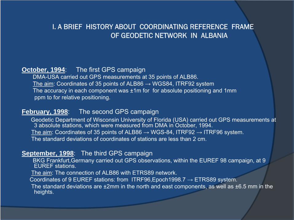
I. A BRIEF HISTORY ABOUT COORDINATING REFERENCE FRAME
OF GEODETIC NETWORK IN ALBANIA
October, 1994: The first GPS campaign DMA-USA carried out GPS measurements at 35 points of ALB86.The aim: Coordinates of 35 points of ALB86 → WGS84, ITRF92 systemThe accuracy in each component was ±1m for for
absolute positioning and 1mm ppm
to for relative positioning.
February, 1998: The second GPS campaign Geodetic Department of Wisconsin University of Florida (USA) carried out GPS measurements at 3 absolute stations, which were measured from DMA in October, 1994.
The aim: Coordinates of 35 points of ALB86 → WGS-84, ITRF92 → ITRF96 system.The standard deviations of coordinates of stations are less than 2 cm.
September, 1998: The third GPS campaign BKG Frankfurt,Germany
carried out GPS observations, within the EUREF 98 campaign, at 9 EUREF stations.
The aim: The connection of ALB86 with ETRS89 network.Coordinates of 9 EUREF stations: from ITRF96,Epoch1998.7 → ETRS89 system. The standard deviations are ±2mm in the north and east components, as well as ±6.5 mm in the heights.
II. DETERMINATION OF TRANSFORMATION PARAMETERS FROM ETRF2000 INTO ALB86 SYSTEM BY IGM FIRENZE-ITALY
November 2007 – May 2008:MGI of Firenze
and MGI of Albania, carried out the GPS measurements in 150 stations of existing geodetic network of ALB86.
The aim: determination of transformation parameters from ITRS/ETRS into ALB86 system.
GPS Albanian Geodetic network was organized in two levels:-
National Dynamic Network (NDN)-
National Static Network (NSN)
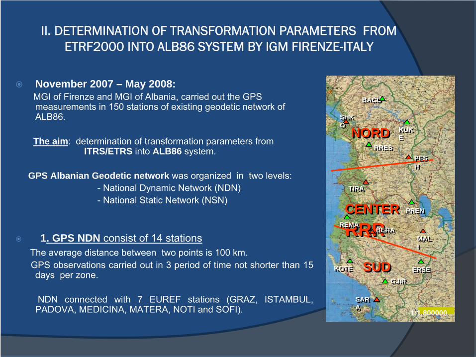
1. GPS NDN consist of 14 stations The average distance between two points is 100 km.GPS observations carried out in 3 period of time not shorter than 15 days per zone.
NDN connected with 7 EUREF stations (GRAZ, ISTAMBUL, PADOVA, MEDICINA, MATERA, NOTI and SOFI).
NORDNORD
CENTER RRR CENTER RRR
SUDSUD
SHK O SHK O
SAR A SAR A
PES H PES H
TIRATIRA
BERABERAMAL I MAL I
KUK E KUK E
BACUBACU
RRESRRES
PRENPREN
ERSEERSE
REMAREMA
KOTEKOTE
GJIRGJIR
1:1.800000
II. DETERMINATION OF TRANSFORMATION PARAMETERS FROM ETRF2000 INTO ALB86 SYSTEM BY IGM FIRENZE-ITALY
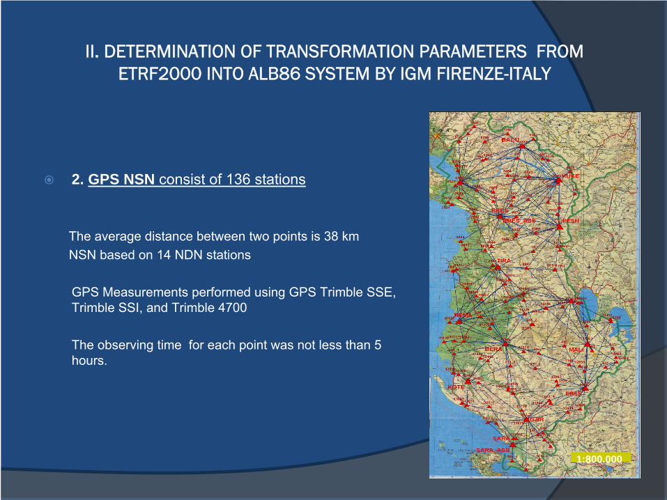
2. GPS NSN consist of 136 stations
The average distance between two points is 38 km NSN based on 14 NDN stations
GPS Measurements performed using GPS Trimble SSE, Trimble SSI, and Trimble 4700
The observing time for each point was not less than 5 hours.
1:800.000
II. DETERMINATION OF TRANSFORMATION PARAMETERS FROM ETRF2000 INTO ALB86 SYSTEM BY IGM FIRENZE-ITALY
3. Computation of NDN
The coordinates of Stations referred ETRF2000, Epoch2008.0. The transformation from ITRF2005 into ETRF2000, it was performed according to
recommendation of EUREF [4].For computation of this common network were used 30 seconds daily Data in RINEX format.
Verification of credible stations
It was necessary to have an accordance between Epoch of NDN Data and the Epoch of conventional reference. This accordance performed according to following relation:
The differences between respective coordinates are less than 0.008m
So, ITRF2005 accepted for further transformation in ETRF2008.
( ) ( ) ( ) ( )0505 052008.0 2000.0 2000.0 2008.0 2000.0ITRF
ITRF ITRFX X X= + • −
II. DETERMINATION OF TRANSFORMATION PARAMETERS FROM ETRF2000 INTO ALB86 SYSTEM BY IGM FIRENZE-ITALY
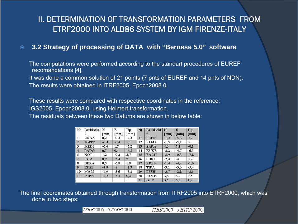
3.2 Strategy of processing of DATA with “Bernese 5.0” software
The computations were performed according to the standart procedures of EUREF recomandations [4].
It was done a common solution of 21 points (7 pnts of EUREF and 14 pnts of NDN). The results were obtained in ITRF2005, Epoch2008.0.
These results were compared with respective coordinates in
the reference:IGS2005, Epoch2008.0, using Helmert transformation. The residuals between these two Datums are shown in below table:
The final coordinates obtained through transformation from ITRF2005 into ETRF2000, which was done in two steps:
II. DETERMINATION OF TRANSFORMATION PARAMETERS FROM ETRF2000 INTO ALB86 SYSTEM BY IGM FIRENZE-ITALY
4. Computation of NSN
NDN stations used as base for GPS observations of NSN
All GPS baselines computed with TGO TRIMBLE software
The
definitive
adjustment
of
150 points (136 of
NSN and
14 of
NDN) performed
with
GEOLAB software.
Mean square error per weight unit resulted 20 mm
Final coordinates obtained in reference ETRF2000, Epoch2008.0, UTM
II. DETERMINATION OF TRANSFORMATION PARAMETERS FROM ETRF2000 INTO ALB86 SYSTEM BY IGM FIRENZE-ITALY
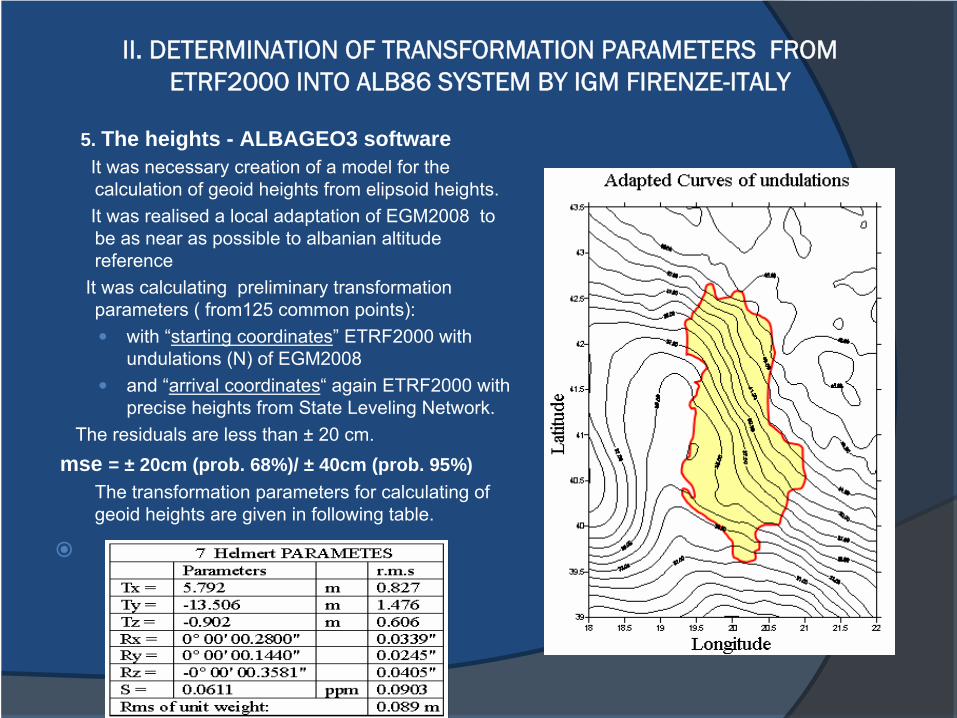
5. The heights - ALBAGEO3 softwareIt was necessary creation of a model for the calculation of geoid heights from elipsoid heights. It was realised a local adaptation of EGM2008 to be as near as possible to albanian altitude reference
It was calculating preliminary transformation parameters ( from125 common points):
with “starting coordinates” ETRF2000 with undulations (N) of EGM2008 and “arrival coordinates“ again ETRF2000 with precise heights from State Leveling Network.
The residuals are less than ±
20 cm. mse = ± 20cm (prob. 68%)/ ± 40cm (prob. 95%)
The transformation parameters for calculating of geoid heights are given in following table.
II. DETERMINATION OF TRANSFORMATION PARAMETERS FROM ETRF2000 INTO ALB86 SYSTEM BY IGM FIRENZE-ITALY
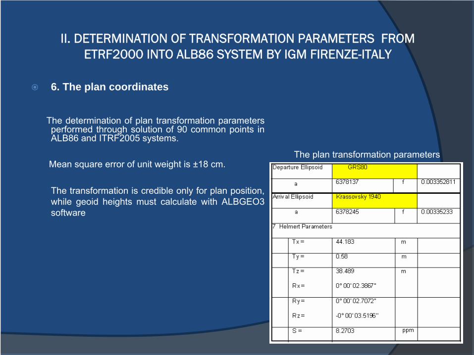
6. The plan coordinates
The determination of plan transformation parameters performed through solution of 90 common points in ALB86 and ITRF2005 systems.
Mean square error of unit weight is ±18 cm.
The transformation is credible only for plan position, while geoid
heights must calculate with ALBGEO3 software
The plan transformation parameters
The new developments brought the necessity of creating a geodetic modernreference in Albania.It was decided the realization of a GNSS permanent network namely Albanian Positioning System (ALBPOS), which is a civilian public service financed from EC.
The main objective of ALBPOS project:the establishment of ETRF2000, Epoch 2008.0 reference
Advantages of ALBOS GNSS network will be:-
It provides a unique system -
Operating space with greater accuracy-
Reduction of systematic errors-
High productivity-
It eliminates the need for using local reference stations -
It provides monitoring of integrity-
Surveyors using RTK receivers would be able to survey with high
accuracy at the few cm range
III. Albanian Positioning System 2009 (ALBPOS)
The project will support the foundation of a modern reference in Albania, which will be base for different applications:
-
Scientific researches -
Monitor of deformations-
Cadastral works-
The land and property registration -
Property Rights-
Road and infrastructure planning-
Positioning and navigation-
Mapping in different scales-
Geology and geophysics -
Development and use of GIS -
Connection to regional and international coordinate networks
III. Albanian Positioning System 2009 (ALBPOS)
The main beneficiaries of the project are:
-
Immovable Property Registration Office (IPRO)-
Agency of Legalization, Urbanization and Integration of Informal Areas and Buildings (ALUIZNI). -
Agency of Restitution and Compensation of Property-
Military Geographic Institute of Albania (MGIA)-
The interested institutes and private topographical companies
Above institutions are responsible for the management and use of the ALBPOS,
while the MGIA is the ownership of it.
III. Albanian Positioning System 2009 (ALBPOS)
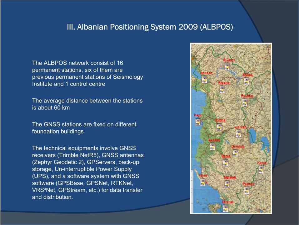
The ALBPOS network consist of 16 permanent stations, six of them are previous permanent stations of Seismology Institute and 1 control centre
The average distance between the stations is about 60 km
The GNSS stations are fixed on different foundation buildings
The technical equipments involve GNSS receivers (Trimble NetR5), GNSS antennas (Zephyr Geodetic 2), GPServers, back-up storage, Un-interruptible Power Supply (UPS), and a software system with GNSS software (GPSBase, GPSNet, RTKNet, VRS³Net, GPStream, etc.) for data transfer and distribution.
III. Albanian Positioning System 2009 (ALBPOS)
The project carried out in following phases:-
GPS site selection and monumentation
of permanent stations-
The installation of equipments and software of GPS Permanente Stations-
Assistance and the training of GPS teams-
Planning and measurements of GPS campaigns-
GPS data processing and evaluation
The Site selection is performed from MGIA and PUT
The contractor (representative of Trimble, Germany) has performed the installation of equipments and software of Permanente Stations, assistance and training of staff .
The observation period was three days: 3 -
5 December 2009 (there were used 3X24 hours, 30 seconds interval), for all 16 permanent stations.were used 30 seconds interval.
The mean Epoch for this campaign is 2009.9 The coordinative reference will be ETRF2000 The
reference stations: DUBR, MATE and SOFI as IGS/EPN in ITRF2005The processing of GPS Permanente Stations does not performed.
III. Albanian Positioning System 2009 (ALBPOS)
For the Future:- The processing of GPS Data must to finish
from contractor- The final coordinates of
GPS Permanente Stations will be ETRS89 in the ETRF 2000, Epoch 2008.0- It will
be perform the transformation of coordinates from ETRF2000, Epoch2008.0 referenceinto local one.
-
It will be check the results of 2007/8 campaigns against ALPOS stations.
Conclusions:
-
The cooperation between IGM Firenze and IGUS
institutes was available, because generally it solved the problem of relations between two coordinate references: ALB86 reference and ITRF2005 reference in ETRF2000(2008.0) realization.
-
There is a use experience and a GNSS base network.
-
The 16 permanent stations would improve the system of geodetic
reference.
-
Installation and maintenance of ALPOS require a continuous attention of the Albanian institutions.
-
UC could help with financial support and consultations.
- A great challenge will be the determination of Albanian Geoid.