Embed Size (px)
Citation preview

Copyright © ESB International Limited, all rights reserved.
Oweninny Wind Farm
Oweninny Environmental Impact Statement
Appendix 12
Road Safety Audit

Farm

Proposed Site Accesses for Oweninny Wind Farm
Development, Bellacorick, Co. Mayo
Stage 1/2 Road Safety Audit
Final Report
1st May 2013
Prepared for
Oweninny Power Ltd.
Traffic Transport and Road Safety Associates Ltd.
14 Penrose Wharf,
Cork
Ireland
t. +353(0)21 555601e. [email protected]

Proposed Site Accesses for Oweninny Wind Farm Development, Bellacorick, Co. Mayo
Stage 1/2 Road Safety Audit
Contents
Document Control Sheet .................................................................................................................i
1 Introduction ................................................................................................................................1
2 Scheme Background ...................................................................................................................2
3 Audit Findings .............................................................................................................................4
4 Audit Statement ..........................................................................................................................9
Appendix A – NRA Approval of Road Safety Audit Team Members
Appendix B – Safety Audit Brief
Appendix C – Road Safety Audit Feedback Form
©TTRSA 2013 ii

Proposed Site Accesses for Oweninny Wind Farm Development, Bellacorick, Co. Mayo
Stage 1/2 Road Safety Audi
1 Introduction
This report presents the findings of a Stage 1/2 Road Safety Audit of the upgrading of three existing site
accesses off the N59 national road, to form entrances for the construction of the Oweninny Wind Farm Development at Bellacorick, Co. Mayo. Abnormal loads are proposed to travel from east to west along the
N59 to the site. 112 (no.) turbines are proposed and each turbine will generate approximately 9 abnormal
loads associated including the nacelle, blade and towers. The blade length will be 56m and the maximum
tower section length 33m.
The scope of the audit is limited to the three proposed upgraded site entrances. The site entrance
drawings have been prepared by Oweninny Power Limited.
The Stage 1/2 Road Safety Audit was undertaken by Traffic Transport and Road Safety Associates Ltd.
(TTRSA) in accordance with the requirements of National Roads Authority (NRA) Design Manual for
Roads and Bridges Volume 5 Section 2 Part 2 - NRA HD 19/12 Road Safety Audit. The Audit Team
members comprised: Matthew Steele and Pamela Townley, both qualified and experienced road safety auditors, approved by the NRA to undertake this road safety audit as detailed within Appendix A. A site
visit was undertaken by both audit team members on 29th April 2013. During the site visit the weather
was dry and the road surface was dry.
A brief, in line with the requirements of NRA HD 19/12 was provided to the Audit Team and is included
as Appendix B.
The audit examines the documents relating to the proposed scheme and on-site observations, and
identifies issues which have an adverse impact on road safety. The audit does not examine or verify the
proposed scheme for compliance with any other standards or criteria. Issues which impact on road
safety are listed as problems or observations within this report, and relate to the documentation
provided upon commencement of the safety audit. Feedback and any revisions to the scheme design provided by the Design Team in relation to the issues identified or recommendations made within the
audit report, are detailed within the Road Safety Audit Feedback Form contained as Appendix C of this
report.
©TTRSA 2013 1

Proposed Site Accesses for Oweninny Wind Farm Development, Bellacorick, Co. Mayo
Stage 1/2 Road Safety Audi
2 Scheme Background
2.1 The proposed scheme
The proposed scheme is the upgrading of three existing site accesses related to the construction of a 112
turbine wind farm at Bellacorick, Co. Mayo. All of the existing accesses are located on the northern side of
the N59 national road. The locations of the three existing accesses are detailed below.
Site Entrance Easting (ITM) Northing (ITM)
Site Entrance No. 1 497770 819800
Site Entrance No. 2 495640 820400
Site Entrance No. 3 498850 819470
2.2 The existing situation
The characteristics of the N59 at the location of site accesses include:
• At Site Entrance No. 1, the surfaced carriageway is 7.7m in width, demarcated as a 3.4m wide
westbound lane and 3.6m wide eastbound lane. The existing junction bell mouth is 24.5m in width at
the stopline. The existing visibility splay to the west is in excess of 215m1, as is eastbound forward
visibility to the access. The existing visibility splay to the east is 180m, as is westbound forward visibility. Increasing the visibility splay to the east and westbound forward visibility, to 215m, is achievable;
• At Site Entrance No. 2, the surfaced carriageway is 6.3m in width, demarcated as two 2.85m wide lanes. The existing junction bell mouth is 45m in width at the stopline. The existing visibility splay to the west
is in approximately 90m, as is eastbound forward visibility to the access. The existing visibility splay to
the east is in excess of 215m, as is westbound forward visibility. Increasing the visibility splay to the west
and eastbound forward visibility, to 215m, is achievable;
• At Site Entrance No. 3, the surfaced carriageway is 6.9m in width, demarcated as a 3.0m wide
westbound lane and 3.2m wide eastbound lane. The existing junction bell mouth is 36.5m in width at
the stopline. The existing visibility splay to the west is in approximately 90m, with eastbound forward
visibility to the access being approximately 100m. The existing visibility splay to the east is approximately 134m, whilst westbound forward visibility is in excess of 215m. Increasing the visibility
splay to the west and eastbound forward visibility, to 215m, is achievable;
• At all of the locations the carriageway is marked with a solid centreline and dashed edge-lining, both
with retro-reflective road studs. The verges are soft and surface water drainage is limited to grips
aligning the carriageway;
• Chevron signing is present in the immediate vicinity of site entrances 1 and 3;
• The posted speed limit for this section of the N59 is 100 kph; and,
• There is no street lighting.
2.3 Recorded Collision Data
The Road Safety Authority online Collstats database has been consulted for the period currently
available (2005 to 2011 inclusive) and indicates that one collision resulting in minor injury was recorded on a Sunday evening in 2011, in Bellacorick village. The collision was not in the vicinity of any of the
proposed site accesses.
1 All visibility splays were measured on site during the road safety audit site visit from a setback of 3m from the edge of the carriageway.
©TTRSA 2013 2

Proposed Site Accesses for Oweninny Wind Farm Development, Bellacorick, Co. Mayo
Stage 1/2 Road Safety Audi
2.4 Information provided for the audit
Documents provided for the audit are detailed below:
• Drawing: 'Swept Path Site Entrance No. 1 - Showing Required Modifications'; Drawing number
QR320201-P-000-000; Dated 22.02.2013
• Drawing: 'Swept Path Site Entrance No. 2 - Showing Required Modifications'; Drawing number
QR320201-P-000-000; Dated 22.02.2013
• Drawing: 'Swept Path Site Entrance No. 3 - Showing Required Modifications'; Drawing number
QR320201-P-000-000; Dated 22.02.2013
2.5 Design Standards
No departures from standards were reported to the audit team.
©TTRSA 2013 3

Proposed Site Accesses for Oweninny Wind Farm Development, Bellacorick, Co. Mayo
Stage 1/2 Road Safety Audi
3 Audit Findings
The primary purpose of a Road Safety Audit is to identify potential safety hazards within the scheme design
or construction as they could affect road users. HD19/12 requires that hazards are termed problems and
also requires the Audit Team to make recommendations, which if implemented, eliminate or mitigate the hazards identified, so the safety hazard is either removed and ceases to be a problem or its impact is reduced
so that a collision resulting in injury is unlikely to occur.
3.1 Problem:
The visibility splay to the east of Site Entrance No. 1 is currently restricted to approximately 180m due to the
presence of tree vegetation and an informal 'Caution Long Vehicles Turning' sign located on the southern sideof the carriageway. Inadequate forward visibility splays of site related turning movements for westbound N59
road-users can lead to a range of types of collisions including loss-of control due to attempted manoeuvres
to avoid collision.
Recommendation:
Cut back the vegetation located on the southern side of the N59 carriageway to the east of the proposed site
entrance, ensuring that this vegetation is maintained at a low level of maximum 0.6m for the full extent of the
visibility splay. Relocate the informal sign outside of the visibility splay.
3.2 Problem:
The gradient of the existing access at the proposed Site Entrance No. 1 does not have a sufficient gradient or
dwell area to permit the safe access from or egress onto, the N59 carriageway, with accessing and egressing
vehicles either potentially losing control when turning, unable to egress or egressing at inappropriate speeds,
or becoming grounded due to the level difference, leading to a range of collision types. No details have been
provided of the gradient of the site entrance following widening and improvement.
Recommendation:
The detailed design and construction of this proposed site entrance should include an appropriate approach
gradient on the access route, including dwell area, to accommodate the length and width of vehicles using
the site entrance. The design and construction of the tie-in and drainage with the edge of the carriageway
should note the super-elevation of the existing N59 carriageway at this location.
©TTRSA 2013 4

Proposed Site Accesses for Oweninny Wind Farm Development, Bellacorick, Co. Mayo
Stage 1/2 Road Safety Audi
3.3 Problem:
As Site Entrance No. 1 will provide the access route to a future visitor centre, the wide junction mouth to
accommodate the swept path access for wind farm delivery/site construction vehicles may lead to N59 eastbound road-users inappropriately turning into the entrance to the eastern sector of the site access and
potentially colliding with egressing vehicles.
Recommendation:
The dual use of this proposed site entrance for site construction and public access to a visitor centre should
be taken into full account within the design, the junction bellmouth of the site entrance should be reduced in width with a stop control priority junction markings and signage when open for public access, but for
example incorporating removable fencing or bollards upon completion of the site construction in order to
retain access for large/long vehicles as wind farm maintenance is required. The provision of any such
removable fencing or bollards should not be positioned to obstruct the visibility splays of the entrance.
Advance highway or local signs indicating the junction to the visitor centre should be provided with the
approval of the highway authority and should not be positioned within the visibility splays of this entrance.
3.4 Problem:
It is unclear from the drawings provided for the audit whether the width of the access road at Site Entrance
No. 1 will be designed and constructed to accommodate two-way traffic, particularly for access to the future
visitor centre. A single carriageway would increase the risk of collision and/or vehicles leaving the road during
attempts to pass oncoming vehicles.
Recommendation:
The design and construction of the access road of Site Entrance No. 1 should accommodate two-way traffic,
through the provision of either two traffic lanes or provision of passing places of suitable entry and exit tapers
and holding length and should have full inter-visibility between on-coming vehicles. Any gated access of the
site should take account of the need for a turning head facility if the gate infrastructure is positioned at a distance into the site.
3.5 Problem:
To the west of the proposed Site Entrance No. 2, the existing height of both the berm aligning the northern
side of the N59 carriageway, its vegetation, and the gradient of the land on the northern side of the berm all
serve to restrict the visibility splay to approximately 90m. The visibility splay to the east is also partially obscured by a young pine tree. These egress visibility splay would not be adequate and may potentially lead
to wind farm related vehicles having to encroach onto the carriageway to achieve visibility, colliding with on-
coming vehicles.
©TTRSA 2013 5

Proposed Site Accesses for Oweninny Wind Farm Development, Bellacorick, Co. Mayo
Stage 1/2 Road Safety Audi
Recommendation:
Provide full clear visibility splays for this proposed site entrance by: reducing the height of this berm to the
west of the site entrance to a maximum of 0.6m (including mature vegetation) ensuring that the structural integrity of the berm is not adversely affected; re-profile the gradient of the land to the west of this proposed
site entrance, and remove the pine tree to the east of the site entrance.
3.6 Problem:
A soft verge highway warning sign is currently located within the eastern extent of Site Entrance No. 2,
which would restrict egress access movements of large/long vehicles or be displaced upon collision with these vehicles.
Recommendation:
Relocate this highway warning sign (with the approval of the highway authority) to ensure that it is not
located within the swept path of large or long vehicles and increase the mounting height of this sign to
ensure that the full visibility of this sign is retained by eastbound road-users.
3.7 Problem:
The condition of the hard-standing surface aligning the N59 carriageway at location for Site Entrance No. 2 is
deforming with rutting present. Uneven surface levels and the dwell and tie-in of the entrance onto the
carriageway can lead to vehicles over-shooting onto the carriageway as vehicle wheels are caught in the
rutted surface, with subsequent collision with through traffic.
Recommendation:
This site entrance should be designed and constructed for the loading and swept path for all types of vehicles
accessing the site, taking full account of the tie-in with the existing edge of the N59 carriageway and surface
water drainage within the design and construction.
3.8 Problem:
Vegetation including uprooted trees currently restrict the egress visibility splay from Site Entrance No. 3 to
the east to approximately 134m, and the corresponding visibility splay to the west is currently restricted to
approximately 90m by both verge vegetation height and existing highway chevron signs indicating the bend
to the right (for N59 eastbound road-users). Inadequate egress visibility and forward visibility of turning
vehicles can lead to a range of collision types.
©TTRSA 2013 6
Proposed Site Accesses for Oweninny Wind Farm Development, Bellacorick, Co. Mayo
Stage 1/2 Road Safety Audi
Recommendation:
Provide full clear visibility splays at this site entrance by removing the vegetation to the east of the entrance
(and maintaining the height of the verge vegetation to a maximum of 0.6m), and cutting and maintaining the verge vegetation to the west of the entrance. The location of the highway chevron signs to the east of the
site entrance should be repositioned slightly setback (northwards from the edge of the carriageway) in
agreement with the highway authority.
3.9 Problem:
It is unclear from the drawings provided for the audit whether the gradient of the existing access located at Site Entrance No. 3 and the profile of the site frontage to the east of the site and within the site will be taken
into full account within the proposed design. Adverse cross-section and long-section gradient of the
proposed site can result unable to safely access the site without losing control of the vehicle or the vehicle
load, leading to direct collision with other vehicles or a range of secondary collisions involving the obstruction
of the carriageway.
Recommendation:
The design and construction of Site Entrance No. 3 should provide a level access gradient to safely
accommodate the swept path and loading of large or long vehicles, noting that the N59 carriageway is super-
elevated within the vicinity of this site entrance and that surface water from both the carriageway and site
entrance drains to the northern edge of the N59 carriageway. The existing Bord Na Mona sign should be
repositioned from the site entrance, ensuring that it is not repositioned within the visibility splay.
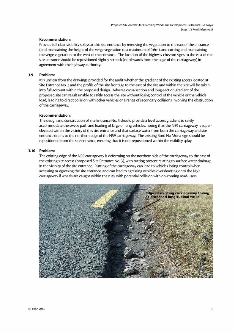
3.10 Problem:
The existing edge of the N59 carriageway is deforming on the northern side of the carriageway to the east of
the existing site access (proposed Site Entrance No. 3), with rutting present relating to surface water drainage
in the vicinity of the site entrance. Rutting of the carriageway can lead to vehicles losing control when
accessing or egressing the site entrance, and can lead to egressing vehicles overshooting onto the N59 carriageway if wheels are caught within the ruts, with potential collision with on-coming road-users.
©TTRSA 2013 7

Proposed Site Accesses for Oweninny Wind Farm Development, Bellacorick, Co. Mayo
Stage 1/2 Road Safety Audi
Recommendation:
As part of the widening of the existing access to form Site Entrance No. 3, repairs should be made to the
adjacent carriageway of the N59 to ensure consistent tie-in and facilitate safe access manoeuvres.
3.11 Observations:
• Advance warning signs with distance plates indicating turning movements of large vehicles should
be provided at least 400m in both directions in advance of each of the three site entrances,
immediately prior to the commencement of the site works.
• The extension eastwards of the access for Site Entrance No. 2 will require full consideration of the
existing culvert which existing site access traverses.
• The proposed design of any highway drainage, signing, public or site related lighting, or gated
infrastructure have not been provided for this audit.
• Any temporary traffic management related to the construction and operation of the site accesses
should be subject to a separate road safety audit.
©TTRSA 2013 8

Proposed Site Accesses for Oweninny Wind Farm Development, Bellacorick, Co. Mayo
Stage 1/2 Road Safety Audi
4 Audit Statement
We certify that we have examined the documentation provided for the audit as detailed in the Section
2.4 of this report. The examination has been carried out in accordance with NRA HD19/12 with the solepurpose of identifying any features of the design that could be removed or modified in order to improve
the safety of the scheme. The problems identified have been noted in this report together with
associated safety improvement suggestions, which we recommend should be studied for
implementation. The Audit has been conducted by the persons named below who have not been
involved with the design of the scheme.
Matthew Steele
(Audit Team Leader)
Signed: Date:
2nd April 2013
Pamela Townley
(Audit Team Member)
Signed: Date:
2nd April 2013
©TTRSA 2013 9

Farm

Proposed Site Accesses for Oweninny Wind Farm Development, Bellacorick, Co. Mayo
Stage 1/2 Road Safety Audi
Appendix A
NRA Approval of Road Safety Audit Team Members
©TTRSA 2013 10

Farm
Proposed Site Accesses for Oweninny Wind Farm Development, Bellacorick, Co. Mayo
Stage 1/2 Road Safety Audi
©TTRSA 2013 11

Farm

Proposed Site Accesses for Oweninny Wind Farm Development, Bellacorick, Co. Mayo
Stage 1/2 Road Safety Audi
Appendix B
Safety Audit Brief
©TTRSA 2013 12

Farm
Proposed Site Accesses for Oweninny Wind Farm Development, Bellacorick, Co. Mayo
Stage 1/2 Road Safety Audi
Stage 1/2 Road Safety Audit BriefProposed Site Accesses for Oweninny Wind Farm Development, Bellacorick, Co. Mayo
NRA Checklist Item Yes/No/ Not Applicable (N/A)
Comment
Design Brief; Yes Undertake a Stage 1/2 Road Safety Audit of three proposed accesses for the Oweninny Wind Farm development at Bellacorick, Co. Mayo. All of the accesses are off the existing N59 national road.
Departures from Standard; Yes No
Scheme Drawings; Yes Drawing: 'Swept Path Site Entrance No. 1 - Showing Required Modifications'; drawing number QR320201-P-000-000 dated 22.02.2013
Drawing: 'Swept Path Site Entrance No. 2 - Showing Required Modifications'; drawing number QR320201-P-000-000 dated 22.02.2013
Drawing: 'Swept Path Site Entrance No. 3 - Showing Required Modifications'; drawing number QR320201-P-000-000 dated 22.02.2013
Other scheme details, e.g. signs schedules, traffic signal staging;
N/A
Collision data for existing roads affected by the scheme;
Yes The Road Safety Authority online Collstats database has been consulted for the period currently available (2005 to 2011 inclusive) and indicates that one collision resulting inminor injury was recorded on a Sunday evening in 2011, in Bellacorick village. The collision was not in the vicinity of any of the proposed site accesses.
Traffic surveys; Yes The NRA Automatic Traffic Counter located on the N59 between Crossmolina and Bangor indicates an AADT flow of approximately 1800 vehicles.
Previous Road Safety Audit Reports and Designer Responses /Feedback Form
N/A
Previous Exception Reports; N/A
Start date for construction and expected opening date;
Yes The timing of construction will be subject to grid connections etc.
Any elements to be excludedfrom audit;
Yes Audit is limited to the site accesses. The internal layout of the site is to be excluded from the audit.
Any other information (list separately).
Yes Abnormal loads are proposed to travel from east to west along the N59 to the site. The number of turbines included in planning is 112 turbines. Each turbine will have approximately 9 abnormal loads associated with it including the nacelle, blade and towers. The blade length will be 56m and the maximum tower section length 33m.
©TTRSA 2013 13

Proposed Site Accesses for Oweninny Wind Farm Development, Bellacorick, Co. Mayo
Stage 1/2 Road Safety Audi
©TTRSA 2013 14