Embed Size (px)
Citation preview
Copyright © ESB International Limited, all rights reserved.
Oweninny Wind Farm
Oweninny Power Ltd.
Environmental Impact Statement
Chapter 10
Water & Aquatic Ecology
June 2013
Oweninny Wind Energy Project
County Mayo
Environmental Impact Statement
June 2013
Table of Contents
10. WATER QUALITY, FISHERIES AND AQUATIC ECOLOGY 10.1
10. 1 INTRODUCTION 10.1 10.1.1 Relevant legislation 10.2 10.1.2 Hydrology of the site 10.3
10. 2 Approach and Methodology 10.3 10.2.1 Electrofishing 10.4 10.2.2 Stream Invertebrate Sampling 10.7 10.2.3 Biological Water Quality Assessment Criteria 10.8
10. 3 RECEIVING ENVIRONMENT 10.9 10.3.1 General Catchment Information 10.9 10.3.2 Inland Fisheries Ireland – Oweninny Report 2012 10.10 10.3.3 Fishery Value 10.11 10.3.4 Electrofishing surveys 10.13 10.3.5 Electrofishing Summary 10.18 10.3.6 EPA Biological analyses. 10.19 10.3.7 Aquafact Biological analyses. 10.23 10.3.8 Ecological Importance and Designated areas 10.23
10. 4 POTENTIAL IMPACT OF THE DEVELOPMENT 10.25 10.4.1 Construction Phase Impacts Pollution of Streams with Suspended Solids 10.25 10.4.2 Pollution with Nutrients Decomposition of Brash After Forestry Clearfelling 10.26 10.4.3 Pollution with Nutrients Decomposition of Brash in Repository Areas 10.28 10.4.4 Construction - Pollution with Nutrients due to Ground Disturbance and Clearfelling Operations 10.29 10.4.5 Construction - Pollution with Other Substances 10.30 10.4.6 Potential Operational Impacts Long-Term Aquatic Effects 10.31 10.4.7 Hydrological impacts 10.31 10.4.8 Decommissioning phase 10.32
10. 5 MITIGATION 10.32 10.5.1 Construction Phase Mitigation - Reduction and Prevention of Suspended Solids Pollution 10.32 10.5.2 Construction Phase Mitigation - Forestry Clearfelling 10.34 10.5.3 Construction Phase Mitigation - Pollution of Watercourses with Nutrients 10.35 10.5.4 Construction Phase Mitigation - Pollution of Watercourses with nutrient from Repository areas. 10.35 10.5.5 Construction Phase Mitigation - Turbine Foundations, Cable Trenches and Upgrade of Tracks 10.35 10.5.6 Construction Phase Mitigation – General Management of Pollution 10.36 10.5.7 Operational Phase Mitigation - Wastewater treatment system 10.37 10.5.8 Operational Phase Mitigation - Habitat Loss 10.37 10.5.9 Operational Phase Mitigation - Obstruction to Movement of Aquatic Fauna 10.37 10.5.10 Operational Phase Mitigation - Hydrological Impacts 10.38 10.5.11 Procedures, Monitoring and Maintenance 10.38
Water and Aquatic Ecology ii

Oweninny Wind Energy Project
County Mayo
Environmental Impact Statement
June 2013
10.5.12 Residual Impacts post mitigation 10.39
10. 6 CUMULATIVE IMPACTS 10.39
10. 7 CONCLUSION 10.40
List of Tables
Table 10-1: Location co-ordinates semi quantitative electrofishing. ...........................................10.6
Table 10-2: Duration of electrofishing times at each site studied................................................10.7
Table 10-3: Location co-ordinates for kick-sampling stations and water sampling site in Lough Dahybaun. ................................................................................................................10.8
Table 10-4: Biotic Index of Water Quality ....................................................................................10.9
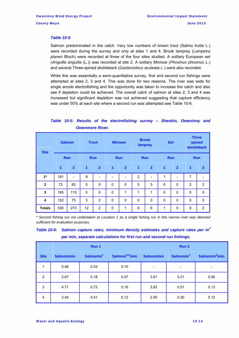
Table 10-5: Results of the electrofishing survey – Sheskin, Oweninny and Owenmore River. 10.14
Table 10-6: Salmon capture rates, minimum density estimates and capture rates per m2 per min, separate calculations for first run and second run fishings....................................10.14
Table 10-7: Length frequency distributions of salmon captured at each site (>0+ salmon highlighted in red)...................................................................................................10.15
Table 10-8: Length frequency distribution of brown trout captured at all sites during the survey................................................................................................................................10.18
Table 10-9: EPA Biological Monitoring Data .............................................................................10.21
Table 10-10: Q-value result for each station ............................................................................10.23
Table 10-11. Results of analyses on a sample collected in L. Dahybaun, January, 2013. All values as mg/l....................................................................................................................10.24
List of Plates
Plate 10-1: Electrofishing Site 1 ..................................................................................................10.4
Plate 10-2: Electrofishing Site 2 ..................................................................................................10.5
Plate 10-3: Electrofishing Site 3 ..................................................................................................10.5
Plate 10-4: Electrofishing Site 4 ..................................................................................................10.6
Plate 10-5: Length frequency distributions of salmon captured at each site and during each fishing run in the case of sites 2, 3 and 4. .........................................................................10.17
List of Figures
Figure 10-1: Oweninny Site Rivers............................................................................................10.41
Figure 10-2: Oweninny River Catchments ................................................................................10.42
Figure 10-3: Electrofishing survey assessment locations .........................................................10.43
Figure 10-4: EPA Biological Assessment Sites.........................................................................10.45
Water and Aquatic Ecology iii

Oweninny Wind Energy Project
County Mayo
Environmental Impact Statement
June 2013
Water and Aquatic Ecology iv
Figure 10-5: Aquafact Biological Water Quality monitoring sites ..............................................10.46
Figure 10-6: Location of Freshwater Pearl Mussel recorded populations on the Deel river .....10.47
Figure 10-7: Lough Dahybaun catchment .................................................................................10.48

Oweninny Wind Energy Project
County Mayo
Environmental Impact Statement
June 2013
10. WATER QUALITY, FISHERIES AND AQUATIC ECOLOGY
10. 1 INTRODUCTION
The rivers of North Mayo, particularly the Moy and its tributaries are a major tourist attraction for both domestic and foreign anglers. In their own right the Owenmore and Oweninny river systems are important fishery rivers in the area. This is clearly set out in the Northwestern Regional Fisheries Board (now subsumed into the Inland Fisheries Ireland (IFI)) publication “Towards a New Era for the Owenmore”. This is a specific catchment management plan for this river with a main objective:
“To ensure that the Owenmore fisheries are effectively managed for today’s generation and conserved for future generations”
The south-easterly flowing Deel river is a tributary of the Moy and also hosts an important population of the protected species of the Freshwater Pearl Mussel (Margaritifera margaritifera). The north-easterly flowing Owenmore river or Cloonaghmore river is also an important local fisheries resource. Maintaining the water quality and fisheries habitat of these rivers is paramount during the development, operation and decommissioning phases of the project.
Historically, the peat harvesting operations at Oweninny had a significant impact on the aquatic ecology of the receiving waters in the catchments draining the area. This arose from loss of some peat silt material from bare peat areas within the site, which sedimented in river beds. In response to this problem and following consultation with the Fisheries Board and the Environmental Protection Agency, Bord na Móna developed a comprehensive system of drainage control using settlement ponds to trap sediment in surface runoff and a bog rehabilitation programme to rewet bare peat areas and encourage vegetative re-growth. Reduction of bare peat areas is effective at reducing loss of peat material to the aquatic environment. These measures, developed in conjunction with the North-western Regional Fisheries Board and the Environmental Protection Agency (EPA), have proved successful in significantly reducing peat particle loss to the aquatic environment with a consequent major improvement in water clarity, ecology and fish habitat. This was evidenced by a major study undertaken by IFI and funded by Bord na Móna between 2005 and 2008. As the bog rehabilitation programme effectiveness continues, further reductions in peat material loss from the site will result as the extent of bare peat areas reduces.
In terms of potential impact on the aquatic environment the proposed wind farm development has the potential to cause sediment material loss from construction areas and pollution due to oil spills and waste material management. However, unlike the peat harvesting operations of the past, only a small fraction of the site will be disturbed by construction and potential sediment and other polluting substances will be controlled by good engineering construction practice and through implementation of a site specific drainage and sediment control plan. This plan integrates the new proposed control measures into the existing peat control measures and will ensure no significant impact on water quality and the aquatic environment.
The Oweninny site is located within the Western River Basin District established under
Water and Aquatic Ecology 10.1

Oweninny Wind Energy Project
County Mayo
Environmental Impact Statement
June 2013
the Water Framework Directive1 which sets the objectives for water quality in the district. The Water Framework Directive rationalises and updates existing water legislation by setting common EU-wide objectives for water quality. It provides for a new, strengthened system for the protection and improvement of water quality and dependent ecosystems. In brief, the legislation provides for:
The protection of the status of all waters (surface water and groundwater)
The establishment of ‘river basin districts’ (RBDs)
The coordination of actions by all relevant public authorities for water quality management in an RBD, including cross-border RBDs
The characterisation of each RBD
The establishment of environmental objectives
The development of programmes of measures and river basin management plans (RBMP).
Galway County Council is the coordinating local authority for the Western RBD set out in the legislation and Mayo County Council is a designated authority for it.
The Western River Basin District – River Basin Management Plan 2009–2015 (published 2009) has been adopted for the river basin district (see www.wfdireland.ie/docs). It establishes four core environmental objectives to be achieved generally by 2015, as follows:
Prevent deterioration: maintain the status of waters classified as High or Good
Restore all waters to at least Good status
Reduce chemical pollution
Achieve water-related protected areas objectives.
10.1.1 Relevant legislation
The Surface Waters Environmental Objectives Regulations (S.I. No. 272/2009) and the Groundwater Environmental Objectives Regulations (S.I. No. 9/2010) set out the measures needed to achieve the environmental objectives established in river basin management plans for surface water and groundwater. The regulations place a legal obligation on public authorities to aim to achieve those objectives in the context of their statutory functions.
For the river water bodies draining the Oweninny site the Western River Basin Management Plan objectives will be to achieve at least good status, and prevent deterioration of existing good and high water quality status.
As part of the assessment of the potential impacts discussions took place with IFI and NPWS to review the assessment needs of the aquatic ecology arising from the development. Resulting from this, electrofishing on the Sheskin Stream, Oweninny river
1 "Directive 2000/60/EC of the European Parliament and of the Council establishing a framework for
the Community action in the field of water policy"
Water and Aquatic Ecology 10.2

Oweninny Wind Energy Project
County Mayo
Environmental Impact Statement
June 2013
and Owenmore river(by Aquafact) were undertaken and biological quality assessment made at a number of locations on rivers draining the general site to update the baseline conditions. This coupled with extensive data available from the IFI fish surveillance monitoring programme and the EPA national water quality assessment programme collected under the Water Framework Directive has been used to establish the baseline and to assess the potential for impact and recommend mitigation as required.
The Deel river, a tributary of the Moy, is designated as a salmonid river under the European Communities (Quality of Salmonid Waters) Regulations 1988 which enables the requirements of the European Directive of 18th July, 1978 (No. 78/659/EEC), the Freshwater Fish Directive. This Directive is scheduled to be repealed in July 2013 with its requirements for salmonid water quality being subsumed into the Water Framework Directive where designated waters will become protected areas.
The Deel river also hosts an important population of the Freshwater Pearl Mussel (Margaratifera margaritifera). Ecological quality objectives for the Freshwater Pearl Mussel Habitat have been set out in the European Communities Environmental Objectives (Freshwater Pearl Mussel) Regulations 2009. These are generally more stringent for FPM catchments requiring high Environmental Quality Ratios equating to High status waters under the WFD. In essence the requirements are at the highest level of water quality.
10.1.2 Hydrology of the site
The Oweninny wind farm site lies within three main river catchments – Owenmore (Oweninny) flowing westwards to Tullaghan Bay on the west coast, Cloonaghmore (a different Owenmore) flowing north east to Killala Bay on the north Mayo coast and the Deel (Shanvolahan) flowing to Lough Conn in the Moy River Catchment. The main rivers draining the site area are shown on Figure 10-1 and the river catchments are shown on Figure 10-2.
The Oweninny site has been comprehensively drained in the past by a series of parallel open ditches to facilitate peat production. Large areas of the site have been stripped to the subsoil layer resulting from harvesting operations. The ditch drains installed in the worked bog discharge to the natural drainage of the area. Bord na Móna has undertaken a bog rehabilitation programme as part of the requirements of the IPPC Licence for the peat harvesting operations which have now ceased. The rehabilitation works are completed and included the blocking of bog drains to allow re-wetting of areas. This has facilitated re-growth of surface vegetation, significantly reducing the loss of peat material from the site to the aquatic environment.
10. 2 Approach and Methodology
No significant limitations were encountered in field surveys or data collection. The assessment was undertaken with reference to the following.
Western River Basin District River Basin Management Plan 2009 – 2015 (www.wfdireland.ie)
Mayo West and Conn Water Management Unit Action Plans, (www.wfdireland.ie)
EPA ENVision environmental mapping system
(http://maps.epa.ie/InternetMapViewer/MapViewer.aspx)
Water and Aquatic Ecology 10.3

Oweninny Wind Energy Project
County Mayo
Environmental Impact Statement
June 2013
Towards a New Era for the Owenmore. A Fisheries Catchment Management Plan for the Owenmore River System, County Mayo, North Western Regional Fisheries Board (now Inland Fisheries Ireland Western River Basin District)
A physical, chemical and biological assessment of fluvial habitat draining the Oweninny Peatlands, North Mayo with reference to peat siltation, Inland Fisheries Ireland, December 2012
Mapping of the Distribution of Margaritifera margaritifera. in The River Deel (Moy Catchment), Co. Mayo. October 2009, A report for Department of the Environment, Heritage & Local Government by Moorkens and McKellen
A Fisheries Survey of the Upper Owenmore River, Co. Mayo, in the vicinity of a the proposed wind farm, Aquafact, September 2012
Aquatic ecological assessment of streams in the proposed wind farm area, Aquafact, April 2013
Each of the project components have been assessed for potential impact on water quality and mitigation identified.
10.2.1 Electrofishing
The requirement for electrofishing of waters which could be affected by the proposed wind farm development was discussed on site with Inland Fisheries Ireland. Following on from this discussion a semi-quantitative electric fishing survey of the locally named Sheskin Stream, upper Oweninny river and on the Owenmore River, Co. Mayo, was carried out on the 29th and 30th July 2012. A total of four sites were electrofished using generator powered equipment energising a single anode. The locations of the fish assessment sites are shown in Figure 10-3 and coordinates are provided in Table 10-1.
Site 1: (30th July 2012) was a river section on the Sheskin Stream immediately downstream from a Bord na Móna access bridge. The river width averaged 8m and the study section was 45m long. Water depth varied from 10-70cm and the reach was a mixture of riffle, glide and pool habitat. The river substrate comprised stones, gravel and some silt and there was also some submerged vegetation at this site.
Plate 10‐1: Electrofishing Site 1
Water and Aquatic Ecology 10.4

Oweninny Wind Energy Project
County Mayo
Environmental Impact Statement
June 2013
Site 2: (30th July 2012) was a river section 18m wide and 22m long. The river banks were relatively high and the electrofishing equipment was positioned on the left bank. Water depths varied from 20-60cm and the substrate comprised stones and boulders with some gravel. The site was mainly a glide with a limited amount of riffle habitat. The site was located about 100m upstream from a Bord na Móna access bridge on the Oweninny river.
Plate 10-2: Electrofishing Site 2
Site 3: (29th July 2012) was a river section with riffle habitat on the Oweninny river which was 15-25m wide. A 45m long by 5m wide section along the right bank was electrofished. Water depth varied from 10-40cm and the substrate was predominantly gravel with some boulders covered in moss. The channel was open and there was also cattle access to the river at this site.
Plate 10-3: Electrofishing Site 3
Water and Aquatic Ecology 10.5
Oweninny Wind Energy Project
County Mayo
Environmental Impact Statement
June 2013
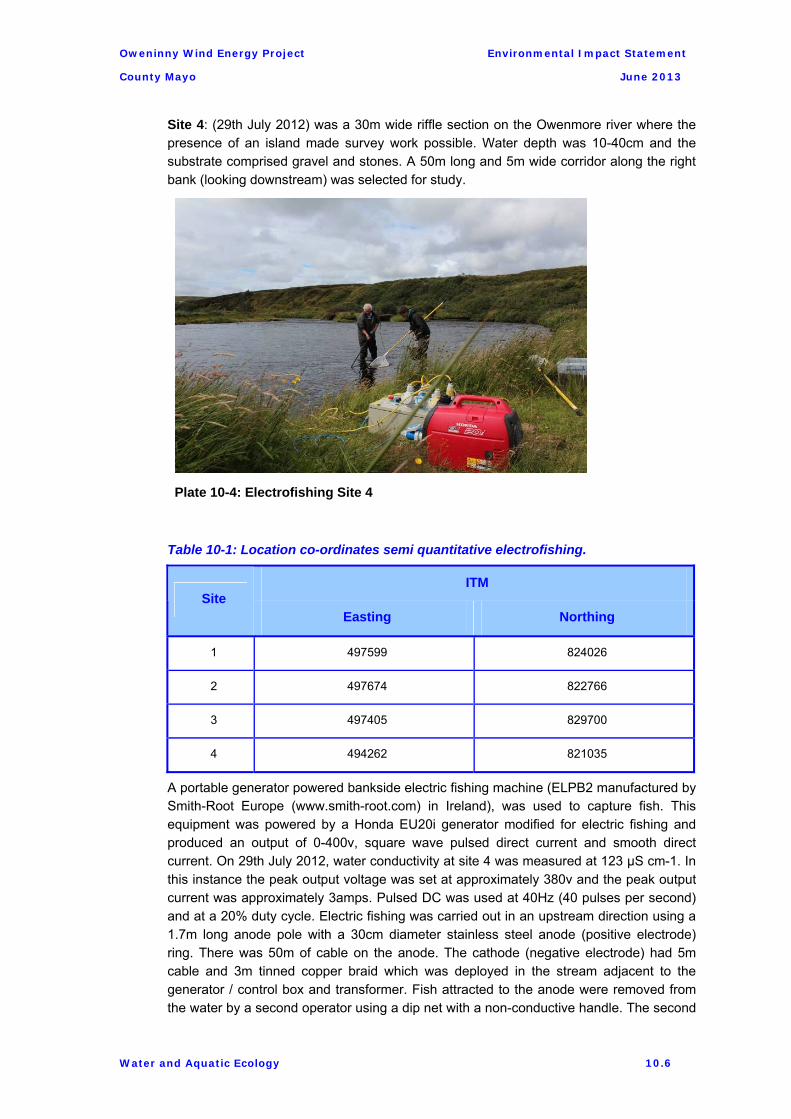
Site 4: (29th July 2012) was a 30m wide riffle section on the Owenmore river where the presence of an island made survey work possible. Water depth was 10-40cm and the substrate comprised gravel and stones. A 50m long and 5m wide corridor along the right bank (looking downstream) was selected for study.
Plate 10-4: Electrofishing Site 4
Table 10-1: Location co-ordinates semi quantitative electrofishing.
ITM Site
Easting Northing
1 497599 824026
2 497674 822766
3 497405 829700
4 494262 821035
A portable generator powered bankside electric fishing machine (ELPB2 manufactured by Smith-Root Europe (www.smith-root.com) in Ireland), was used to capture fish. This equipment was powered by a Honda EU20i generator modified for electric fishing and produced an output of 0-400v, square wave pulsed direct current and smooth direct current. On 29th July 2012, water conductivity at site 4 was measured at 123 µS cm-1. In this instance the peak output voltage was set at approximately 380v and the peak output current was approximately 3amps. Pulsed DC was used at 40Hz (40 pulses per second) and at a 20% duty cycle. Electric fishing was carried out in an upstream direction using a 1.7m long anode pole with a 30cm diameter stainless steel anode (positive electrode) ring. There was 50m of cable on the anode. The cathode (negative electrode) had 5m cable and 3m tinned copper braid which was deployed in the stream adjacent to the generator / control box and transformer. Fish attracted to the anode were removed from the water by a second operator using a dip net with a non-conductive handle. The second
Water and Aquatic Ecology 10.6

Oweninny Wind Energy Project
County Mayo
Environmental Impact Statement
June 2013
operator also carried a bucket for holding fish. It was not possible to deploy stop nets because of water conditions. At sites 2, 3 and 4 two timed fishing runs were carried out while at site 1 only a single timed fishing run was carried out due to the occurrence of heavy rainfall. The catch was then related to the area fished and the duration of fishing. This semi-quantitative approach to electric fishing is now favoured by many fishery workers who regard electric fishing as a relative method of describing fish populations rather than an absolute method. For example, the Scottish Fisheries Coordination Centre (SFCC) now bases its information on fish populations on electric fishing first run data. Captured fish were anaesthetised using 2-phenoxyethanol and forklengths were measured to the nearest millimetre. All fish were released back into the river after recovery from anaesthesia.
Table 10-2 details the duration of run 1 and run 2 fishing times at each site studied.
Table 10-2: Duration of electrofishing times at each site studied
Site Length Width Area Fishing Time (min)
m m m2 Run 1 Run 2 Combined
1 45 8 360 35 0 35
2 22 18 396 27 23 50
3 45 5 225 35 30 65
4 50 5 250 30 30 60
Totals 1,231 127 83 210
10.2.2 Stream Invertebrate Sampling
Sampling was carried out on the 22nd January 2013. Seven sites were selected for this assessment in the Sruffaunnamuingabatia River (Station 1), Muing River (Station 2), Eskeragh Bridge (Fiddaunatooghaun River which is a tributary of the Shanvolahan River), (Station 3), Shanvolahan River (Station 4), the Fiddaunmuing River (Stations 5 and 6) and the Fiddaunoran River (Station 7). The last two streams are tributaries of the Owenmore/Cloonaghmore river which enters the sea northwest of Killala.
The two-minute kick sampling method was employed to collect samples of macroinvertebrates for analysis. This involved placing a standard hand net of pore size 500μm in the river, facing upstream and disturbing the river bed in front of the net mouth. The sampler then moved in a diagonal direction upstream to ensure that different micro-habitats were included in the sample. The kick method dislodges macroinvertebrates from the substrates and submerged plant material. This was continued for approximately two minutes and the resulting sample was transferred from the net to a plastic bucket and fixed using a 70% ethanol solution.
The samples were then transported to the AQUAFACT laboratories where the macro invertebrates were removed and identified using stereoscopic microscopes and the appropriate keys (see references) by a qualified freshwater taxonomist. The resulting species list was then used to assign a Biotic Index value (Q-Value) to the sampled streams.
Water and Aquatic Ecology 10.7

Oweninny Wind Energy Project
County Mayo
Environmental Impact Statement
June 2013
One sample was also taken at Lough Dahybaun for water chemistry analysis. Table 10-3 shows the location co-ordinates of where the kick-sampling was carried out, along with the Lough Dahybaun site.
Table 10-3: Location co-ordinates for kick-sampling stations and water sampling
site in Lough Dahybaun.
ITM Station Water body
Easting Northing
1 Sruffaunnamuinggabatia 499690 823850
2 Muing 497752 819841
3 Fiddaunatooghaun 503870 818876
4 Shanvolahan 504275 819821
5 Fiddaunnamuing 505035 821364
6 Fiddaunnamuing 507466 822041
7 Fiddaunoran 507361 823853
L. Dahybaun Lough Dahybaun 500346 819458
Fast flowing stretches of the river or riffles were selected as these are typically the best aerated and contain the most pollution-sensitive macroinvertebrates. Where riffle zones were not available, a steady-flowing and sometimes deeper glide section of the stream was sampled.
10.2.3 Biological Water Quality Assessment Criteria
The Biological River Quality Classification System (Q-Scheme) has been in use in Ireland since 1971. It has undergone a number of modifications since then and has been included in the Water Framework Directive river surveillance and operational monitoring programme.
For the purpose of this assessment, now carried out routinely by the EPA, benthic invertebrates have been divided into five indicator groups according to tolerance of pollution, particularly organic pollution. In order to determine the biological quality of the river, the Q-scheme index is used whereby the analyst assigns a Biotic Index value (Q-Value) based on macro invertebrate results. The Biotic Index is a quality measurement for freshwater bodies that range from Q1 - Q5 with Q1 being of poorest quality and Q5 being pristine/ unpolluted. The criteria presented in Table 10-4 were used in the assessment of ecological water quality.
Water and Aquatic Ecology 10.8

Oweninny Wind Energy Project
County Mayo
Environmental Impact Statement
June 2013
Table 10-4: Biotic Index of Water Quality
Biotic Index EPA Water Quality WFD Ecological Status
Q5 Good High
Q4-5 Fair - Good High
Q4 Fair Good
Q3-4 Doubtful - Fair Moderate
Q3 Doubtful Poor
Q2-3 Poor - Doubtful Poor
Q2 Poor Bad
Q1-2 Bad - Poor Bad
Q1 Bad Bad
10. 3 RECEIVING ENVIRONMENT
10.3.1 General Catchment Information
Tributary rivers, the Inagh, Alterderg, Fiddaunfrankagh and Glenora rivers rise on the southern slopes of the Maumkeogh Mountains and drain southwards, joining to become the Oweninny river which gives the site its name. The Oweninny River drains the central part of the site. The Oweninny river is fed by the Srahmeen river and Knockmoyle Stream from the west and by numerous small tributary streams from the east (Fiddaungal, Fiddaunnaglogh, Fiddaunnameenabane, Fiddauncam and the Fiddaunnamuinggeery) before entering the Oweninny wind farm site. The Owenniny is joined by the Sheskin Steam which drains the forested south-eastern slopes of Slieve Fyagh and also forms the site’s internal boundary with the O’Boyles Bog area. The Oweninny and the Fiddaunnamuingeery form part of the site boundary. The Sruffaunnamuingabatia, which drains the Bellacorick Iron Flush SAC area within the site, flows westwards and joins the Oweninny river. The Oweninny is also joined by the Muing River which drains Lough Dahybaun within the site. The Owenmore drains a catchment of approximately 332 km2 before entering the sea at Tullaghan Bay. The Oweninny flows southwards, externally to the site and effectively dividing the site in two before joining the Owenmore turning westwards after Bellacorick Bridge and paralleling the N59. The Owenmore is joined at this location by the Altanabrocky river flowing northwards from the Nephin Mountains.
The north-eastern part of the site is drained by small tributaries (Fiddaunfura) which rise in Shanvodinnaun and flow eastwards to the main easterly flowing river, also named the Owenmore. This river rises in the townlands of Cluddaun and Shanetra to the north of the site before flowing eastwards becoming the Cloonaghmore River before entering the sea at Rathfran Bay which is within Killala Bay. It is also referred to as the Palmerstown River. The Cloonaghmore River drains a catchment of approximately 132 km2 before entering the sea at Rathfran Bay.
The south-eastern part of the site drains to tributaries of the Shanvolahan River
Water and Aquatic Ecology 10.9

Oweninny Wind Energy Project
County Mayo
Environmental Impact Statement
June 2013
(Fiddaunagosty, Shanvolahan and Fiddauntooghaun) before entering the Deel River which drains to Lough Conn and eventually joins the River Moy at Ballina before entering the sea at Killala Bay. The River Moy drains a catchment of approximately 1,966 km2 before entering the sea at Killala Bay. The area of the Shavolahan catchment before it enters the Deel River is approximately 23.7 km2.
The upper catchments of these rivers could potentially be impacted by the wind farm development through loss of materials leading to increased suspended solids and sedimentation on river beds and entry of pollutants such as oils and waste debris entering watercourses.
10.3.2 Inland Fisheries Ireland – Oweninny Report 2012
In response to the historic impact of peat silt loss to the rivers draining the Oweninny bog area following more than 40 years of industrial milled peat production and the control measures introduced by Bord na Móna, a comprehensive study of the impacts and effectiveness of these measures was undertaken by staff of the former North Western Regional and Central Fisheries Board (now Inland Fisheries Ireland (IFI)) between 2005 and 2008. The study, funded by Bord na Móna, assessed the freshwater fisheries habitat in the Owenmore, Deel and Cloonaghmore upper catchments2.
Biological investigations included fish stock assessment, salmon ova mortality studies and floral and invertebrate analyses. Water chemistry was also reviewed and an assessment of the degree of peat siltation on salmonid spawning habitat due to peat harvesting activities made. The study also endeavoured to validate and monitor the anticipated reduction in peat silt export due to the peatland rehabilitation efforts undertaken by Bord na Móna. This latter objective was considered important for stakeholder confidence in the Bord na Móna rehabilitation plan, including the proposal to decommission the silt pond network servicing the worked bog area over time.
The key conclusions of the study were as follows:
Peat silt discharges from the Oweninny catchment in the last decade of active peat production were generally recognised as being substantially reduced relative to the quantities that were historically observed prior to and during the 1980s. This is attributed to a programme of staff training, improvements in the number and type of peat settlement ponds installed by Bord na Móna and investment in equipment to enable more effective and timely management of these.
Additional sediment control was introduced by Bord na Móna on foot of the Integrated Pollution Prevention Control Licence (IPPC Licence) granted by the Environmental Protection Agency (EPA) up to the time that peat harvesting ceased on the site, which led to further reductions in sediment loss from the site.
The major rehabilitation of the bog production fields initiated in 2003 and substantially completed by 2005 included drain blocking or plugging, effectively reducing water table fluctuations and rewetting the production area. This led to an observed
2 Kennedy Bryan, McLoughlin Derek and Caffrey Joe, A physical, chemical and biological
assessment of fluvial habitat draining the Oweninny Peatlands, North Mayo with reference to peat siltation, Inland Fisheries Ireland, Swords Business Campus, Swords, Co. Dublin, 2012
Water and Aquatic Ecology 10.10

Oweninny Wind Energy Project
County Mayo
Environmental Impact Statement
June 2013
substantial visual reduction in the sedimentation of peat silt deposits during the 2006 angling season in the Owenmore River.
Statistically significant and large reductions in sedimented peat were recorded at two of the historically most heavily impacted sites, at Sheskin and in the upper Cloonaghmore River at Doobehy which have been attributed to the Bord na Móna rehabilitation plans. Further reductions at other sites were observed including the Oweninny (Junction) and at Cloonaghmore (Correens).
Decommissioning of the silt pond network over the peatland area has continued, in consultation with NWRFB Inspectors, since 2008.
The study clearly indicated the effectiveness of the control measures introduced for sediment loss from the site and stated that;
“The rehabilitation plan implemented by BnM must be acknowledged for its overall effectiveness and for the relatively short interval before large reductions in the export of peat silt to adjacent watercourses was evident”.
The report also recommended actions going forward to build on the success to date and ensure continued reduction in sediment loss from the site as follows:
an annual inspection of silt ponds should be undertaken where the competence or stability of the pond is suspected, or where ponds are susceptible to erosion due to their proximity to watercourses.
the possibility of creating vegetation buffer zones under the Native Woodland Scheme at natural low points should be examined.
Sections of the riparian area along the Muing river bank have also been periodically maintained, or cleared, by Bord na Móna from the silt pond to several hundred metres upstream of it. This involves removal of the bankside material and vegetation leading to a loss of overhanging cover for fish. A review of the bank clearing exercises along the Muing River should be undertaken.
The proposed Oweninny wind farm development will not lead to any significant increase in the level of existing peat silt loss to the rivers draining the site. A Drainage and Sediment control plan will be implemented for the site which integrates into the existing Bord na Móna sediment control measures (see Chapter 19). Settlement lagoons followed by overland flow will be provided at each turbine and substation building and also at the batching plant, borrow pit , Visitor Centre and O&M building locations. There will be no direct discharge to the existing river system within the site from construction activities associated with the wind farm development.
10.3.3 Fishery Value
The importance of the fisheries in the Oweninny catchment to Inland Fisheries Ireland – Western River Basin District is described in a number of publications including in their report discussed in Section 10.3.2 above which states as follows:
“The rivers are important salmon and trout fisheries for both local and tourist anglers and are also valuable property rights. The Owenmore river is a renowned salmon and sea-trout fishery, mostly in private ownership. BnM are fishery owners on the Oweninny river, its principal tributary, and the Central Fisheries Board has a minor interest in this river and in Lough Dahybaun whose rights are
Water and Aquatic Ecology 10.11

Oweninny Wind Energy Project
County Mayo
Environmental Impact Statement
June 2013
also vested, in part, in BnM. A comprehensive breakdown of the ownership rights on the Owenmore is contained in the fisheries catchment management plan (NWRFB 20033). The fishery rights on the Cloonaghmore River are vested in the State and traditionally this was a prized river for sea trout, with a late summer grilse run in September. The Shanvolahan River was, at one stage, an important spawning and nursery area for salmon and trout. It drains into the Deel River which is a spring salmon, grilse and brown trout fishery, and is the most significant tributary of Lough Conn and of the wider Moy catchment.”
The fisheries value of the Owenmore River flowing through Bangor Erris is also highlighted in the Fisheries Catchment Management Plan prepared by the Northwestern Regional Fisheries Board in 2003 which indicated that:
“Native Irish fish species recorded in the catchment included the Atlantic Salmon (Salmo salar), the Brown trout and Sea trout (Salmo trutta), the Three-spined stickleback (Gasterosteus aculeatus) and the European Eel (Anguilla anguilla). Unconfirmed reports of migratory lampreys, from a lower section of the Owenmore River, predate the 1950’s. Recent electro fishing operations have recorded the presence of another lamprey species in various locations Introduced species are limited to the Minnow (Phoxinus phoxinus) and the catchment is ecologically significant due to the absence of any of the other exotic introductions e.g. Pike, Perch, Loaches or Cyprinids that are now widespread elsewhere.”
The Mayo Angling Guide 20124, published by Inland Fisheries Ireland provides a brief description of the Owenmore, Oweninny, Deel and Cloonaghmore (Palmerstown) river fisheries which are summarised as follows:
Owenmore: Much of the water is held by various syndicates with about 6.5 km near Bangor Erris leased by the Bangor Angling Club. The river is characteristically wild, with riffles glides and deep pools providing good fishing with generally clear banks to facilitate angling. The Owenmore tends to fish best during the run-off of a spate event. Receives a small run of spring salmon with a prolific run of grilse in mid summer and fishes well from July on to end September. It receives a good run of sea trout from mid summer also.
Oweninny: The major tributary of the Owenmore is the Oweninny, which is a small wild spate river only producing good angling on a dropping spate. Ownership of the lower section is very fragmented but fishing rights are state owned in the townlands of Srahmeen, Knockmoyle and Laghtnavak from an area 300m upstream of the confluence of the Oweninny and Sheskin Streams for around 8.5 km to its confluence with the Shrameen river. This section is described as rugged and wild and suitable only for the more adventurous anglers.
River Deel: The River Deel rises high in the Nephin Beg mountains before flowing 45km through moorland and pastures, through the town of Crossmolina, before entering the northern end of Lough Conn. It is the largest of the Moy tributaries and offers a wide variety of angling experiences ranging from dry fly fishing for trout to
3 Towards a New Era for the Owenmore, North Western Regional Fisheries Board, 2003
4 County Mayo Game Angling Guide, published by Inland Fisheries Ireland, 2012
Water and Aquatic Ecology 10.12
Oweninny Wind Energy Project
County Mayo
Environmental Impact Statement
June 2013
salmon fishing in the lower reaches.
Cloonaghmore (Palmerstown) river: Once famed for its sea trout fishery it now receives only a moderate run which is more prolific towards the end of the season (October). It holds a resident stock of small brown trout, and is currently closed for salmon angling as a conservation measure.
The game fishery associated with the rivers draining Oweninny is an important local resource used by angling clubs and by fishing tourists attracted to the area. It is important that this fishery resource be protected during all phases of the Oweninny wind farm development.
10.3.4 Electrofishing surveys
Inland Fisheries Ireland Surveys
Inland Fisheries Ireland undertake fish stock surveys on river sites throughout Ireland as part of the fish sampling programme for the Water Framework Directive (WFD). Fish sampling is required by both national and European law, with Annex V of the WFD stipulating that rivers are included within the monitoring programme and that the composition, abundance and age structure of fish fauna are examined. IFI fish assessments are reported on http://wfdfish.ie/. As part of this surveillance monitoring programme fish monitoring has been undertaken on the Deel river at Crossmolina in the past, 20085 and 20126. In 2008 six fish species were recorded of which roach was the most common. Species included salmon Salmo salar, brown trout Salmo trutta, eel Anguilla Anguilla, lamprey, roach Rutilus rutilus, perch Perca fluviatili and pike Esox lucius. In 2012 the preliminary report indicates the presence of salmon, eel, lamprey, roach and pike. Brown trout was not recorded. Roach and Perch were again abundant at the site.
Aquafact Electrofishing survey
The project aquatic ecologists Aquafact carried out an electrofishing survey at sites agreed with IFI in 2012. The fish species detected during the electrofishing survey are similar to those described in IFI reports and are presented in Salmon predominated in the catch. Very low numbers of brown trout (Salmo trutta L.) were recorded during the survey and only at sites 1 and 4. Brook lamprey (Lampetra planeri Bloch) were recorded at three of the four sites studied. A solitary European eel (Anguilla anguilla (L.)) was recorded at site 2. A solitary Minnow (Phoxinus phoxinus L.) and several Three-spined stickleback (Gasterosteus aculeata L.) were also recorded.
While this was essentially a semi-quantitative survey, first and second run fishings were attempted at sites 2, 3 and 4. This was done for two reasons. The river was wide for single anode electrofishing and the opportunity was taken to increase the catch and also see if depletion could be achieved. The overall catch of salmon at sites 2, 3 and 4 was increased but significant depletion was not achieved suggesting that capture efficiency was under 50% at each site where a second run was attempted see Table 10-6.
5 Central and Regional Fisheries Board, Sampling Fish for the Water Framework Directive 2008, 6 Inland Fisheries Ireland, Preliminary Synopsis of WFD Surveillance Monitoring Fish Stock Surveys at River
Sites in the Western River Basin District, May/July 2012
Water and Aquatic Ecology 10.13
Oweninny Wind Energy Project
County Mayo
Environmental Impact Statement
June 2013
Table 10-5.
Salmon predominated in the catch. Very low numbers of brown trout (Salmo trutta L.) were recorded during the survey and only at sites 1 and 4. Brook lamprey (Lampetra planeri Bloch) were recorded at three of the four sites studied. A solitary European eel (Anguilla anguilla (L.)) was recorded at site 2. A solitary Minnow (Phoxinus phoxinus L.) and several Three-spined stickleback (Gasterosteus aculeata L.) were also recorded.
While this was essentially a semi-quantitative survey, first and second run fishings were attempted at sites 2, 3 and 4. This was done for two reasons. The river was wide for single anode electrofishing and the opportunity was taken to increase the catch and also see if depletion could be achieved. The overall catch of salmon at sites 2, 3 and 4 was increased but significant depletion was not achieved suggesting that capture efficiency was under 50% at each site where a second run was attempted see Table 10-6.
Table 10-5: Results of the electrofishing survey – Sheskin, Oweninny and
Owenmore River.
Salmon Trout Minnow Brook
lamprey Eel
Three spined
stickleback
Run Run Run Run Run Run
Site
1 2 1 2 1 2 1 2 1 2 1 2
1* 191 - 9 - - - 2 - 1 - 7 -
2 72 83 0 0 0 0 5 5 0 0 2 2
3 165 115 0 0 0 1 1 1 0 0 0 0
4 102 75 3 2 0 0 0 0 0 0 0 0
Totals 530 273 12 2 0 1 8 6 1 0 9 2
* Second fishing run not undertaken at Location 1 as a single fishing run in this narrow river was deemed sufficient for evaluation purposes.
Table 10-6: Salmon capture rates, minimum density estimates and capture rates per m2
per min, separate calculations for first run and second run fishings.
Run 1 Run 2
Site Salmon/min Salmon/m2 Salmon/m2/min Salmon/min Salmon/m2 Salmon/m2/min
1 5.46 0.53 0.10 - - -
2 2.67 0.18 0.07 3.61 0.21 0.06
3 4.71 0.73 0.16 3.83 0.51 0.13
4 3.40 0.41 0.12 2.50 0.30 0.12
Water and Aquatic Ecology 10.14
Oweninny Wind Energy Project
County Mayo
Environmental Impact Statement
June 2013
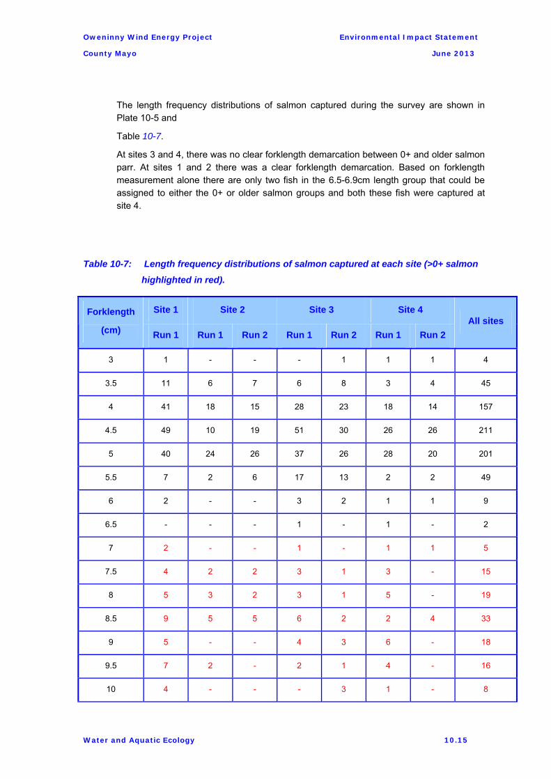
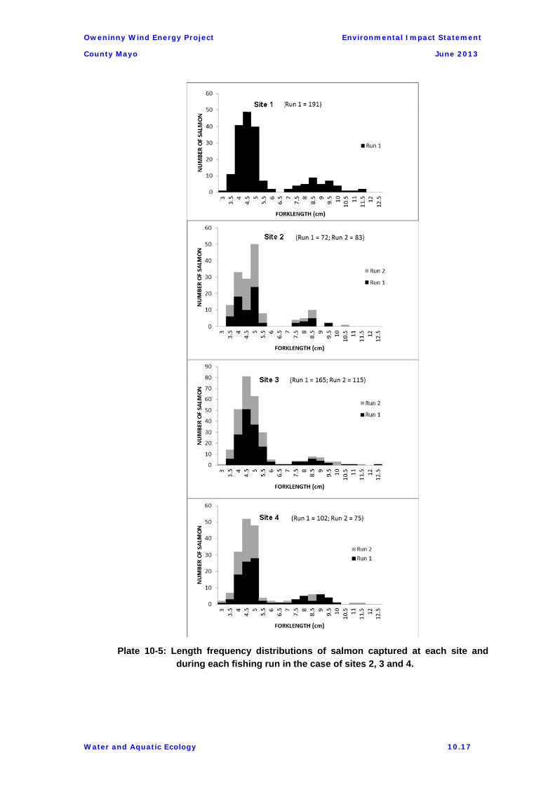
The length frequency distributions of salmon captured during the survey are shown in Plate 10-5 and
Table 10-7.
At sites 3 and 4, there was no clear forklength demarcation between 0+ and older salmon parr. At sites 1 and 2 there was a clear forklength demarcation. Based on forklength measurement alone there are only two fish in the 6.5-6.9cm length group that could be assigned to either the 0+ or older salmon groups and both these fish were captured at site 4.
Table 10-7: Length frequency distributions of salmon captured at each site (>0+ salmon
highlighted in red).
Site 1 Site 2 Site 3 Site 4 Forklength
(cm) Run 1 Run 1 Run 2 Run 1 Run 2 Run 1 Run 2
All sites
3 1 - - - 1 1 1 4
3.5 11 6 7 6 8 3 4 45
4 41 18 15 28 23 18 14 157
4.5 49 10 19 51 30 26 26 211
5 40 24 26 37 26 28 20 201
5.5 7 2 6 17 13 2 2 49
6 2 - - 3 2 1 1 9
6.5 - - - 1 - 1 - 2
7 2 - - 1 - 1 1 5
7.5 4 2 2 3 1 3 - 15
8 5 3 2 3 1 5 - 19
8.5 9 5 5 6 2 2 4 33
9 5 - - 4 3 6 - 18
9.5 7 2 - 2 1 4 - 16
10 4 - - - 3 1 - 8
Water and Aquatic Ecology 10.15

Oweninny Wind Energy Project
County Mayo
Environmental Impact Statement
June 2013
Site 1 Site 2 Site 3 Site 4 Forklength
(cm) Run 1 Run 1 Run 2 Run 1 Run 2 Run 1
All sites
Run 2
10.5 1 - 1 1 - - - 3
11 1 - - 1 - - 1 3
11.5 2 - - - 1 - 1 4
12 - - - - - - - 0
12.5 - - - 1 - - - 1
Totals 191 72 83 165 115 102 75 803
Note: Blank cells indicates no fork length of that size recorded
Water and Aquatic Ecology 10.16
Oweninny Wind Energy Project
County Mayo
Environmental Impact Statement
June 2013
Plate 10-5: Length frequency distributions of salmon captured at each site and during each fishing run in the case of sites 2, 3 and 4.
Water and Aquatic Ecology 10.17
Oweninny Wind Energy Project
County Mayo
Environmental Impact Statement
June 2013
The length frequency distributions of salmon captured during runs 1 and 2 at sites 2, 3 and 4 were similar and there is no evidence that larger salmon were captured during the first run. The attempt to achieve a significant depletion at sites 3 and 4, where 5m wide corridors along the right bank were electrofished was unsuccessful. When the salmon catches from the first and second runs are combined for sites 2, 3 and 4 the minimum estimated densities of salmon per square metre at these sites are 0.71, 1.24 and 0.39, respectively.
These statistics are quite high for semi-quantitative electrofishing. It should be noted that the survey work was carried out at the end of July in a particularly wet and therefore favourable year for 0+ salmon survival. Had the survey work been carried out at the end of September the estimated density of salmon (particularly 0+ fish) would have been much lower.
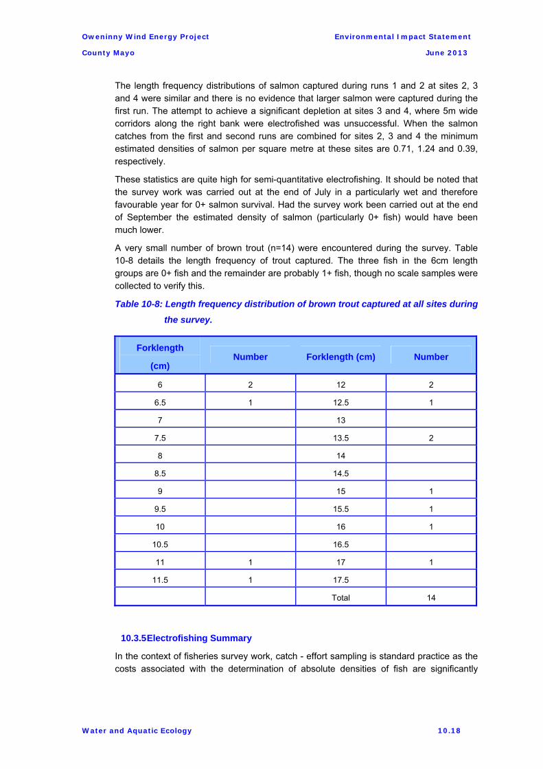
A very small number of brown trout (n=14) were encountered during the survey. Table 10-8 details the length frequency of trout captured. The three fish in the 6cm length groups are 0+ fish and the remainder are probably 1+ fish, though no scale samples were collected to verify this.
Table 10-8: Length frequency distribution of brown trout captured at all sites during
the survey.
Forklength
(cm) Number Forklength (cm) Number
6 2 12 2
6.5 1 12.5 1
7 13
7.5 13.5 2
8 14
8.5 14.5
9 15 1
9.5 15.5 1
10 16 1
10.5 16.5
11 1 17 1
11.5 1 17.5
Total 14
10.3.5 Electrofishing Summary
In the context of fisheries survey work, catch - effort sampling is standard practice as the costs associated with the determination of absolute densities of fish are significantly
Water and Aquatic Ecology 10.18
Oweninny Wind Energy Project
County Mayo
Environmental Impact Statement
June 2013
higher in terms of manpower and time spent surveying when compared with the semi-quantitative approach taken during this survey. Other workers (Strange et al. 19897; Crozier & Kennedy 19948) have compared the results of semi-quantitative electric fishing results with those obtained using quantitative methods and found that the results of the semi-quantitative approach were meaningful in the context of results obtained by using quantitative methods.
The results of the survey show that juvenile Atlantic salmon are abundant at all sites studied and this finding is in keeping with the catchment-wide assessment of the conservation status of salmon in the Owenmore River made by the Standing Scientific Committee (Anon., 2010)9.
The widespread occurrence of brook lamprey recorded during the survey suggests that, had lamprey habitat been targeted during the survey, high densities may have been recorded.
The paucity of juvenile brown trout at the sites studied is not easily explained. Sites 3 and 4 were riffle habitat which was particularly suited to salmon. However, sites 1 and 2 would have been expected to support more trout as these sites contained glide and some pool habitat. It is possible that the success of salmon in the catchment may be at the expense of brown trout at those locations where both species are competing for spawning and nursery habitat.
10.3.6 EPA Biological analyses.
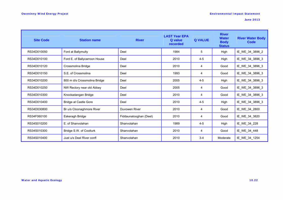
The Environmental Protection Agency carries out biological water quality assessments on a rolling three year basis at river sites in Ireland as part of the Water Framework Directive river monitoring programme. The biological quality data collected is used in the status assignment of river water bodies in conjunction with other water quality parameters. EPA biological monitoring data for the rivers draining the Oweninny site were obtained from the EPA geoportal website (http://gis.epa.ie/DataDownload.aspx) and is presented in Table 10-9. The EPA site locations are shown on Figure 10-4.
The EPA assessment indicates that water quality in the rivers draining the Oweninny site is generally of good to high status. The more recent EPA survey (2011) of the Owenmore river flowing through Bangor Erris indicates the status as high at most locations with one location at good (south east of Srahnakilly). The Muing river is rated as Moderate (2008) indicating some anthropogenic impact on this river. This has been attributed to peat harvesting impacts by the EPA10. The north-easterly flowing Owenmore (Cloonaghmore/Palmerstown) River is also assessed as being at good status (2010)
7 Strange, C.D., Aprahamian, M.W. & Winstone, A.J. (1989). Assessment of a semi-quantitative
electric fishing sampling technique for juvenile Atlantic salmon, Salmo salar L., and trout, Salmo trutta L., in small streams. Aquaculture and Fisheries
8 Crozier, W.W. & Kennedy, G.J.A. (1994). Application of semi-quantitative electrofishing to juvenile salmonid stock surveys. Journal of Fish Biology, 45, 159-164.
9 Report of the Standing Scientific Committee on the status of Irish salmon stocks in 2009 and precautionary
catch advice for 2010 & Appendix VI – Owenmore River p160.
10 EPA, Integrated water Quality Report, Galway , Mayo and Sligo 2011, published 2012
Water and Aquatic Ecology 10.19

Oweninny Wind Energy Project
County Mayo
Environmental Impact Statement
June 2013
Water and Aquatic Ecology 10.20
along its length. The Deel river was also assessed as good to high at locations along its length. Tributaries of the main rivers such as the Duvowen on the Cloonaghmore and the Fiddaunnatooghaun and Shanvolahan on the Deel are also generally of good to high water quality status with the exception of one location just above the confluence of the Shanvolahan and Deel rivers.

Oweninny Wind Energy Project
Environmental Impact Statement
June 2013
Table 10-9: EPA Biological Monitoring Data
Site Code Station name River LAST Year EPA
Q value recorded
Q VALUE
River Water Body
Status
River Water Body Code
RS33M010100 Just u/s Owenmore River Muing 2008 3-4 Moderate IE_WE_33_2157
RS33O040050 Br SE Srahnakilly Owenmore (Oweninny) 2011 4 Good IE_WE_33_3204
RS33O040090 300 m u/s Bellacorick Bridge Owenmore (Oweninny) 1990 4-5 High IE_WE_33_3204
RS33O040100 Bellacorick Bridge Owenmore (Oweninny) 1990 5 High IE_WE_33_3204
RS33O040150 1.1 km d/s Bellacorick Br Owenmore 2005 4-5 High IE_WE_33_3204
RS33O040250 S. of Tawnaghmore (nr School) Owenmore 2011 4-5 High IE_WE_33_3204
RS33O040270 W. of Largan Owenmore 2011 4-5 High IE_WE_33_3204
RS33S030150 Bridge 1 km u/s Oweninny R Owenmore (Sheskin steram) 2011 4-5 High IE_WE_33_3204
RS34C030060 Bridge near Lecarrownwaddy Owenmore/Cloonaghmore 1989 5 High IE_WE_34_397
RS34C030100 Bridge near Belville Owenmore/Cloonaghmore 2010 4 Good IE_WE_34_397
RS34C030150 Ballintober Bridge Owenmore/Cloonaghmore 2010 4 Good IE_WE_34_397
RS34C030200 Tonrehown Bridge Owenmore/Cloonaghmore 2010 4 Good IE_WE_34_3976
RS34C030270 1.2 km u/s Palmerstown Br Cloonaghmore 2010 4 Good IE_WE_34_3976
RS34C030280 200 m u/s Palmerstown Bridge Cloonaghmore 1989 4 Good IE_WE_34_3976
RS34C030310 Palmerstown Bridge (RH side) Cloonaghmore 1989 4 Good IBAS_ID WE 291
RS34D010025 Ford S.W. of Knockbrack Deel 2010 4 Good IE_WE_34_3896_1
Water and Aquatic Ecology
10.21
Oweninny Wind Energy Project
Environmental Impact Statement
June 2013
Water and Aquatic Ecology
10.22
Site Code Station name River LAST Year EPA
Q value recorded
Q VALUE
River Water Body
Status
River Water Body Code
RS34D010050 Ford at Ballymulty Deel 1984 5 High IE_WE_34_3896_2
RS34D010100 Ford E. of Ballycarroon House Deel 2010 4-5 High IE_WE_34_3896_3
RS34D010120 Crossmolina Bridge Deel 2010 4 Good IE_WE_34_3896_3
RS34D010150 S.E. of Crossmolina Deel 1993 4 Good IE_WE_34_3896_3
RS34D010200 800 m d/s Crossmolina Bridge Deel 2005 4-5 High IE_WE_34_3896_3
RS34D010250 NW Rectory near old Abbey Deel 2005 4 Good IE_WE_34_3896_3
RS34D010300 Knockadangan Bridge Deel 2010 4 Good IE_WE_34_3896_3
RS34D010400 Bridge at Castle Gore Deel 2010 4-5 High IE_WE_34_3896_3
RS34D030800 Br u/s Cloonaghmore River Duvowen River 2010 4 Good IE_WE_34_2800
RS34F060100 Eskeragh Bridge Fiddaunatooghan (Deel) 2010 4 Good IE_WE_34_3820
RS34S010200 E. of Shanvolahan Shanvolahan 1989 4-5 High IE_WE_34_228
RS34S010300 Bridge S.W. of Coolturk Shanvolahan 2010 4 Good IE_WE_34_448
RS34S010400 Just u/s Deel River confl Shanvolahan 2010 3-4 Moderate IE_WE_34_1254

Oweninny Wind Energy Project
County Mayo
Environmental Impact Statement
June 2013
10.3.7 Aquafact Biological analyses.
The results of the biological quality Q assessments at seven sites assessed by Aquafact are provided in Table 10-10, see Figure 10-5.
When analysed, Stations 1, 2, 5 and 6 were given a biotic index score of Q3-4, indicating that the stretches of river at those locations are slightly polluted. A biotic index score of Q4 to Q3-4 was assigned to stations 3, 4 and 7 indicating that pollution levels were lower.
Table 10-10: Q-value result for each station
Station Location Biotic Index
Assigned Quality Status
Approximate Status
1 Sruffaubnnamuigabatia
Q3-4 Slightly Polluted
Moderate
2 Muing River (just upstream Owenmore River)
Q3-4 Slightly Polluted
Moderate
3 Fiddaunnatooghaun (Eskeragh Bridge) Q4 to Q3-4
Unpolluted/Slightly Polluted
Good
4 Shanvolahan River (east of Shanvolahan) Q4 to Q3-4
Unpolluted/Slightly Polluted
Good
5 Fiddaunmuing (headwaters)
Q3-4 Slightly Polluted
Moderate
6 Fiddaunmuing (Gortnahurra Lower)
Q3-4 Slightly Polluted
Moderate
7 Fiddaunoran upstream of confluence with the Owenmore
Q4 to Q3-4 Unpolluted/Slightly Polluted
Good
10.3.8 Ecological Importance and Designated areas
As described in detail in Chapter 9 the site abuts the Bellacorick Bog Complex Special Area of Conservation (also a proposed Natural Heritage Area). The potential for impact on the ecology of these areas arising from the wind farm development is discussed in detail in Chapter 9. The rivers draining the eastern (Owenmore/Cloonaghmore) and southeastern (Shanvolahan and Fiddaunatooghaun) part of the site also flow through the Bellacorick Bog Complex designated areas in these locations.
The Shanvolahan is a tributary of the Deel river which supports an important population of Margaratifera margaratifera the Freshwater Pearl Mussel. The population of this protected species was mapped in 2009 by Moorkens and Killeen for the Department of Environment Heritage and Local Government11. The nearest recorded freshwater pearl mussel
11 Moorkens E. and Killeen I. Mapping of the distribution of Margaritifera margaratifers in the River Deel (Moy
Catchment),Co. Mayo. October 2009, A report for Department of the Environment, Heritage & Local Government
Water and Aquatic Ecology
10.23
Oweninny Wind Energy Project
County Mayo
Environmental Impact Statement
June 2013
population is located some 8 km downstream of the Oweninny site boundary, see Figure 10-6.
Lough Dahybaun is a special area of conservation partly located within the Oweninny site. It is drained by the Muing river. Results of the analyses on the water sample collected in Lough Dahybaun are shown in Table 10-11 below. With the exception of ammonium all parameters were less than detectable limits and would comply fully with the high status requirements of chemical parameters set out in the European Communities Environmental Objectives (Surface Waters) Regulations 2009 and the Salmonid water quality standards set out in the regulations of 1988. This is indicative of the pristine nature of this water body.
Table 10-11. Results of analyses on a sample collected in L. Dahybaun, January,
2013. All values as mg/l.
Parameter Suspended soils
mg/l
Phosphorus
Ammonia Nitrate Nitrite
Lough Dahybaun
< 2
<0.01 as PO4
(<0.003 as mg P/l)
0.022 MG/L as (NH4)
(0.017 mgN/l)
<0.44 MG/L as NO3
(<0.099
mg N/L)
<0.017 MG/L as NO2
(<0.005 MG n/L)
High Status < or = to 0.025
mg P/l (mean)
Total Ammonia
High Status < or = to
0.04 mg N/l (mean)
Dissolved Inorganic Nitrogen
High Status (37.5 psu) < or = to 0.17 mgN/l
European Communities
Environmental Objectives (Surface Waters)
Regulations 2009
-
Good Status < or = to 0.035
mg P/l (mean)
Good Status < or = to
0.065 mg N/l (mean)
Dissolved Inorganic Nitrogen
Good Status (37.5 psu) < or = to 0.25 mgN/l
Salmonid Water Quality Standards –
S.I. No. 293 of 1988
< or = to 25 mg/l - < or = to 1 mg/l NH4
- < or = to 0.05 mg/l
NO2
Construction within the Lough Dahybaun catchment is limited to one wind turbine, crane hardstand and access tracks, see Figure 10-7.
Water and Aquatic Ecology
10.24

Oweninny Wind Energy Project
County Mayo
Environmental Impact Statement
June 2013
10. 4 POTENTIAL IMPACT OF THE DEVELOPMENT
The potential significant impacts on aquatic ecology are as follows:
Pollution with suspended solids due to runoff of soil from construction areas.
Pollution with nutrients due to ground disturbance during construction and impacts of clearfelling c. 36 hectares of the forest plantation.
Pollution with nutrients due to decomposition of brash after forest clearfelling and from repository area.
Pollution during construction phase with substances such as fuels, lubricants, waste concrete, waste water from site toilet and wash facilities, etc.
Pollution with surface drainage water from paved areas and track surfaces during operation.
Hydrological impact due to changes in the flow rates of streams/rivers
Pollution with suspended solids through surface drainage water from peat repository.
Permanent loss of habitat due to culverting or bank/stream alteration.
Obstruction to upstream movement of aquatic fauna due to culverting.
10.4.1 Construction Phase Impacts Pollution of Streams with Suspended Solids
In the absence of adequate mitigation, suspended sediment due to runoff of soil from construction areas, forestry clearance operations or due to disturbance of fine sub-surface sediments can have negative impacts on invertebrate and plant life and on all life stages of salmonid fish.
The proposed development site has varying levels of peat cover ranging from 0.0 m to 3.0 m over glacial deposits which are also evident across the site. The possibility of erosion and loss of sediment to the aquatic environment during construction arising from the disturbance of these areas or removal of vegetation could generate suspended solids giving rise to the following potential impacts:
Suspended sediment can settle on spawning areas, infill the intra-gravel voids and smother the eggs and alevins (newly hatched fish) in the gravel.
Bed load (coarse material transported along the bottom of a stream) and settled sediments can infill pools and riffles, reducing the availability and quality of rearing habitat for fish.
Suspended sediment can reduce water clarity and visibility in a stream, impairing the ability of fish to find food items.
Settled sediments can smother and displace aquatic organisms such as macroinvertebrates, reducing the amount of food items available to fish.
Increased levels of sediment can displace fish from prime habitat into less suitable areas.
Suspended solids can abrade or clog the gills of salmonid fish. It takes a high concentration of solid wastes to clog a fish gill and cause asphyxiation, but only a little to cause abrasions and thus permit the possibility of infections.
Water and Aquatic Ecology
10.25
Oweninny Wind Energy Project
County Mayo
Environmental Impact Statement
June 2013
Bog failure/slippage, which could result in a major impact on the receiving waters, including extensive fish kills and loss of other aquatic flora and fauna, is addressed in the peat stability risk assessment report in Appendix 4.
Therefore, the contamination of water courses with suspended solids is a potentially significant impact of the proposed development and would be classified as a moderate/major potential impact on all potentially affected streams should the impact manifest.
10.4.2 Pollution with Nutrients Decomposition of Brash After Forestry Clearfelling
Decaying brash, generated from forest plantation clearfell has the potential to release nutrients such as phosphorous into surface runoff where felling occurs on peat soils which have limited absorption capacity for phosphorous.
“Any organic matter (particularly recently dead material such as brash or roots) that is left on site to rot will release phosphorus and nitrogen. The breakdown of brash, roots and other organic matter takes a number of years. Potentially, therefore, a clearfell site may continue to release phosphorus to the aquatic zone for at least three years after clearfelling. The rate of decomposition is influenced by temperature, moisture and humidity. Consequently, phosphorus loss tends to be greatest during the warmer months and may be particularly problematic during a flood event following a prolonged hot and dry period.” (Forest Service 200812).
Felling of the commercial forest plantation within the Oweninny site boundary is planned in a scheduled manner over a number of years, see Chapter 15, regardless of whether the wind farm is developed or not. The required clearfelling for Oweninny wind farm will not add significantly to the environmental impact that would arise from the normal forestry operations on the commercial plantations within the site.
In Ireland it is now recognised that a significant potential source of nutrient leaching to receiving waters from forestry on peat comes via decaying organic matter, including the foliage and branches, unwanted stems, stumps and dead roots, left on site after crop thinning or felling which are added to the soil at the same time that nutrient uptake is reduced. (Hutton et al 200813; Kennedy 200514; Campbell & Foy 200815; Rogers et al 200816). Dr Martin McGarrigle of EPA indicates that standing crop of 20 kg/ha phosphorus
12 Forest Service (2008) Forestry and Freshwater Pearl Mussel Requirements Site Assessment and
Mitigation Measures. Department of Agriculture, Fisheries and Food
13 Hutton S.A., Harrison S.S.C.& O’Halloran J. (2008) An evaluation of the role of forests and forest
practices in the eutrophication and sedimentation of receiving waters. Western River Basin
District Project
14 Kennedy, N. (2005) An examination of the causes and factors related to the recent eutrophication
of Carrowmore Lake. North Western Regional Fisheries Board.
15 Campbell, E. & Foy, B. (2008) Lough Melvin Catchment Management Plan. Northern Regional
Fisheries Board
16 Rogers et al (2008) EPA STRIVE Programme 2007–2013 Quantification of Erosion and
Phosphorus Release from a Peat Soil Forest Catchment (2000-LS-3.2.4-M2)
Water and Aquatic Ecology
10.26
Oweninny Wind Energy Project
County Mayo
Environmental Impact Statement
June 2013
in brash may have loss rates “similar to intensive farmland with just 10% loss per annum” (McGarrigle 200817).
In a study of a peat soil forest catchment in the Burrishoole river system Rodgers et al. (200816) stated that: “Significant increases in P concentrations and loads were observed at the downstream station after clearfelling and harvesting compared with the P concentrations and loads at the upstream station. Phosphorus load release rates were 2,243.9 g TRP/ha per year in the harvested catchment and 20 g TRP/ha per year in the undisturbed forest catchment.” Whereas the study did not quantify the contribution that different aspects of the forestry operation made to the elevated phosphorus figures, it is clear that decomposition of brash was regarded as a significant contributor in the Burrishoole study.
In contrast the PEnrich study prepared for the EPA for COFORD which focused on the Ballinagee forest plantation and nutrient losses post clearfelling, found low levels of phosphorous in the receiving waters despite the forest plantation being located on blanket peat. “The most striking result of the study was the absence of any significant detrimental influence of forestry or forest operations on phosphorus concentrations or transported phosphorus in surface waters in the Ballinagee River catchment.” (Machava et al 200718) It was believed that this may have been due to a lowering of the water table due to improved drainage and reduced surface runoff, so much so that the water table was below the zone of P in the soil and hence resulted in no leaching of P.
Clearfelling of up to 36 ha of commercial forests will be carried out to facilitate wind farm construction. This felling will occur as both linear sections to facilitate access track development and as keyhole felling coupes within the forest plantation at the proposed turbine locations. There are two areas where this will occur, seven turbines in the catchment of the Muing river, and in the northern Corvoderry area where three turbines and associated access tracks will be constructed. A full description of forestry at Oweninny is provided in Chapter 15.
Due to the spatial dispersion of the clearfelling, the impact from nutrient enrichment will be less than would occur in the case of more intensive felling. Brash arising from the felling will be used in the protection of extraction tracks. In deep peat areas which coincide with forest plantation the turbine foundation footprints, cranepad footprints and access track footprints will be excavated during construction and material transported to the peat repository area. Brash embedded on the surface of these areas will also be transported to the peat repository area.
Excavation will include the surface brash material and a mixture of brash, peat and mineral soil from the excavated areas will be deposited in the specially constructed site repository. The repository locations with respect to the surface water hydrology of the site are indicated on Figure 10-1 and Drawings Number QR320201-P-000-025 and
17 McGarrigle, M. (2008) Agricultural Phosphorus Losses to Water – A Review. EPA, Castlebar
National Water Conference, Galway, 11-12 June 2008 www.epa.ie 18 Machava Ján, McCabe Olive, O'Dea,Philip, Cabral Raquel and Farrell, Edward P, Forest
Ecosystems Research Group, University College Dublin, Forestry Operations and Eutrophication – PEnrich. (2000-LS-3.2.2-M2), Synthesis Report,
Water and Aquatic Ecology
10.27

Oweninny Wind Energy Project
County Mayo
Environmental Impact Statement
June 2013
QR320201-P-000-026. The repository area has a thin peat cover over glacial till comprising mineral soils. The repository will be filled in cells to a maximum depth of one metre.
10.4.3 Pollution with Nutrients Decomposition of Brash in Repository Areas
Decaying brash has the potential to elevate phosphorus levels in the Muing river system and upper Owenmore river if left on site within the catchment. However, the brash material generated by the harvesting operations carried out to facilitate wind farm construction at sites within the Muing river catchment will be excavated together with peat and mineral soil from the glacial till and deposited within the designated repository area.
The repository is located in the general catchment area of the Sruffaunnamuingabati river and Oweninny river. Drainage from the repository area will be directed to settlement ponds with subsequent overland flow. There will be no direct hydraulic connectivity to any receiving waters. The repository is founded on mineral soil beneath the thin peat layer. Boreholes, to a depth of 20m, undertaken in the repository area as part of the development of the existing Bellacorick wind farm development indicate very shallow peat (either zero or less than 0.3m) with a minimum of approximately 3m of silty sand and gravel below the peat layer and then boulder clay. No bedrock was encountered.
In contrast to peat, mineral soil has a higher absorption capacity for phosphorus due principally to the naturally high concentrations of free iron and aluminium oxides and hydrous oxides in the soil (Sharpley 199519, Morgan, 199720; Daly et al., 200021). In a literature review on forest and water eutrophication undertaken for the Water Framework Directive Programme of Measures22, the authors indicated that
“In general, acid mineral soils will tend to immobilize P, while peaty soils, with their very low concentrations of Fe and Al, will tend to leach P”
The literature survey also states that
“…… phosphorus transport in groundwater is generally ignored in catchment studies and monitoring programmes, due to the high P-retention properties of mineral soil.”
19 Sharpley, A.N. 1995. Identifying sites vulnerable to phosphorus losses in agricultural runoff. Journal of Environmental Quality, 24: 947–951.
20 Morgan, M.A. 1997. The behaviour of soil and fertiliser phosphorus. In H. Tunney, O.T. Carton,
P.C. Brookes and A.E. Johnston (eds.) Phosphorus Loss from Soil to Water. CAB International, Wallingford, UK, pp. 137–149.
21 Daly, K., Jeffrey, D. and Tunney, H., (2001). The effect of soil type on phosphorus
sorption capacity and desorption dynamics in Irish grassland soils. Soil Use and
Management 17: 12–20.
22 Hutton SA, Harrison SSC and O’Halloran J Department of Zoology, Ecology and Plant Science,
Environmental Research Institute University College Cork, Water Framework Directive, Western River Basin District, Programme of Measures, Forest and Water National Study Forest and Surface Water, Eutrophication and Sedimentation Literature Review 2008.
http://www.wfdireland.ie/docs/22_ForestAndWater/Forest%20and%20water%20Eutrophication_Sedimentation%20Literature%20review%20.pdf
Water and Aquatic Ecology
10.28
Oweninny Wind Energy Project
County Mayo
Environmental Impact Statement
June 2013
It also references a study of forest harvesting on mineral soil (Renou & Cummins, 200223) which indicated that
“…. phosphorus leached through the low-sorption organic forest litter layer but was retained by the upper layers of the mineral soil and did not leave the site.”
The adsorption capacity of phosphorus was further evidenced in related field studies undertaken by UCC24 which reported on clearfell forest catchments on a variety of soils.
Phosphorus released by the decomposition of the brash in the repository would have high potential for adsorption by the mineral soils in the repository base and in the drainage channels and settlement ponds which will be excavated into the mineral soil stratum also in this area.
Phosphorus loss by erosion of the mineral soils could still occur and this is assessed in Section 10.4.4 below.
In the Corvoderry area where the peat depths are low and underlain by mineral soils the brash will not be removed from the construction area but will be windrowed at least 20m from any water course. There are no major drains flowing from this area and flow is generally diffuse. The impact from nutrient release associated with felling operations in this area will not be significant.
10.4.4 Construction - Pollution with Nutrients due to Ground Disturbance and Clearfelling Operations
Nutrients Adsorbed or Chemically Bound to Eroded Suspended Solids
Several studies in the USA have found increases in both nitrogen and phosphorus export into streams following forestry felling, particularly in association with organic particles (Golladay & Webster 198825; Likens et al 197026). Giller et al (200227). These studies concluded that phosphates released into streams after clear-felling are mainly attached to small soil particles and are carried into watercourses if there is sediment input and increased erosion following clear-felling.
23 Renou, F. and Cummins, T. 2002. Soil as a key to sustainable forest management. In F.,
Convery, and J., Feehan, (eds.), Achievement and Challenge, Rio + 10 and Ireland. The Environmental Institute, University College Dublin, Dublin, pp 85-90.
24 Hutton SA, Harrison SSC and O’Halloran J Forests and Surface Water Eutrophication and
Sedimentation FORWATER, Final Report
http://www.wfdireland.ie/docs/22_ForestAndWater/Forest%20and%20Water_UCC_Draft%20Final%20Report.pdf
25 Golladay, S.W. and Webster, J.R. (1988) Effects of clear-cut logging on wood breakdown in
Appalachian mountain streams. American Midland Naturalist 119(1): 143-155.
26 Likens, G.E., Borman, F.H., Johnson, N.M., Fisher, D.W. and Pierce, R.S. (1970) Effects of forest
cutting and herbicide treatment on nutrient budgets in the Hubbard Brook watershed ecosystem.
Ecological Monographs 40: 23-47
27 Giller, P.S., Johnson, M. and O’Halloran, J. (2002) Managing the impacts of forest clearfelling on stream
environments. COFORD, Dublin.
Water and Aquatic Ecology
10.29
Oweninny Wind Energy Project
County Mayo
Environmental Impact Statement
June 2013
A range of studies in Ireland and abroad have indicated that peat cannot ‘store’ significant amounts of phosphorus, therefore phosphorus applied to these soils are not retained for long but leach to surface and ground waters. The potential for loss of added phosphorus from peatland soils with low levels of iron and aluminium has been recognised for at least three decades, (Cummins & Farrell 200328). In the Irish context Daly et al. (200129) and Styles (200430) concluded that peat soils have limited capacity to chemically bind phosphorus and create any phosphorus reserves. Daly & Styles (200531) found that “peat soils and high organic matter soils did not chemically adsorb P in the same way that mineral soils do. … The concept of P “build-up” cannot be applied to peat soils in the agronomic sense. … These soils are vulnerable to P loss through a lack of sorbtion capacity and binding energy rather than high rates of desorption to solution.”
With regard to the Oweninny site the disturbed soil will consist of both peat with low adsorption capacity for phosphorous and mineral soil which has a high adsorption capacity. However, the site consisted of blanket bog subsequently commercially harvested and phosphorus fertiliser would only have been applied to forest plantation locations in the past. Phosphorous from rainfall would traditionally have been taken up by bog vegetation prior to harvesting. An increase in phosphorus loss associated with rainfall on bare peat has been suggested by Inland Fisheries Ireland however this would be at very low levels and would decrease further as bare peat areas become revegetated. The main potential source of phosphorus loss is associated with erosion of mineral soils with adsorbed phosphorus. Peat particles will have little or no adsorbed phosphorus. The drainage control system has been designed to settle out soil particles and therefore, phosphorous loss associated with mineral soil particle loss is considered to be low at this site.
10.4.5 Construction - Pollution with Other Substances
The potential exists for a range of construction related pollutants to enter watercourses during construction. Any of the following will have deleterious effects on fish, plants and invertebrates if allowed to enter watercourses in an untreated and/or uncontrolled manner.
Raw or uncured concrete and grouts associated with the batching plant operations or deliveries of concrete to the site
28 Cummins, T & Farrell, E. P. (2003) Biogeochemical impacts of clearfelling and reforestation on blanket
peatland streams I. phosphorus. Forest Ecology and Management 180 545–555
29 Daly, K., Jeffrey, D. and Tunney, H., (2001). The effect of soil type on phosphorus sorption capacity and
desorption dynamics in Irish grassland soils. Soil Use and Management 17: 12–20.
30 Styles, D., (2004). Phosphorus dynamics in some Irish soils: the influence of laboratory drying, soil
characteristics and season. Ph.D. Thesis, Dublin University.
31 Daly, K and Styles, D. (2005) Environmental RTDI Programme 2000–2006. Eutrophication from Agricultural
Sources – Phosphorus Chemistry of Mineral and Peat Soils in Ireland. (2000-LS-2.1.1b-M2) Final Report
Prepared for the Environmental Protection Agency by Teagasc, Johnstown Castle, Wexford
http://www.epa.ie/downloads/pubs/research/water/epa_eutrophication_agricultural_ertdi38_final.pdf
Water and Aquatic Ecology
10.30
Oweninny Wind Energy Project
County Mayo
Environmental Impact Statement
June 2013
Wash down water from exposed aggregate surfaces, cast-in-place concrete and from concrete trucks.
Fuels, lubricants and hydraulic fluids for equipment used on the development site.
Waste from on site toilet and wash facilities.
10.4.6 Potential Operational Impacts Long-Term Aquatic Effects
Pollution with Surface Runoff from Completed Development
Wind farm operation produces no discharges and, other than lubricants, uses no chemicals. The risk of significant pollution from paved areas after construction is minimal. Nevertheless, due care and best practice will be required to prevent any contamination of surface waters with hydrocarbons.
The wind farm will have the potential for pollution of watercourses with suspended solids due to eroding of track surfaces and drains.
There will be some potential for impact to occur associated with the maintenance operations carried out on the turbines and the electrical substations and from the use of the O&M facility and Visitor Centre. These include:
Leakage or spillage of fuels, lubricants and hydraulic fluids from equipment used on the development site.
Waste from on site toilet and wash facilities contaminating surface and groundwater through failure of the waste water treatment systems serving the electrical substations, O&M building and Visitor Centre.
Permanent Loss of Habitat and Obstruction to Upstream Movement of Aquatic Fauna Due to Culverting, Track Construction & Upgrading
The network of wind farm access tracks intersects streams shown on EPA stream mapping (www.epa.ie) at a number of locations on the Muing river (3) and the Sruffaunnamuingabatia (2), and also traverses some first order streams in the headwaters of the Owenmore/Cloonaghmore ad Shanvolahan rivers within the site. The habitat loss due to widening of tracks will be insignificant as simple box culvert bridging is proposed on the Muing River and Sruffaunnamuingabatia and all crossings will be in accordance with the Inland Fisheries Ireland Requirement for Protection of Fisheries Habitat during Construction and Development Works32. The upgrading of the site tracks will not have a significant negative impact on fish movement.
10.4.7 Hydrological impacts
Hydrological impacts are assessed in Chapter 19. Approximately 3.9% of the Muing river catchment and less than 2% of the other river sub-catchments will be affected by the development. Additionally, settling ponds constructed as part of the erosion and sediment control plan for the site will provide a further degree of flow attenuation. No significant impact from changes to hydrology arising from development on the site is predicted.
32 Murphy D, Eastern Regional Fisheries Board Fisheries Protection Guidelines, Requirement for Protection of
Fisheries Habitat during Construction and Development Works
Water and Aquatic Ecology
10.31
Oweninny Wind Energy Project
County Mayo
Environmental Impact Statement
June 2013
10.4.8 Decommissioning phase
The decommissioning phase would be expected to have similar potential impacts to water quality mainly arising from soil disturbance during decommissioning and with the potential for pollutants such as fuels, oils and greases to enter water courses. However, by this stage surface re-vegetation resulting from the bog rehabilitation programme will be well established and this will act as a silt trapping mechanism on the site reducing the potential from soil run off impact to occur.
10. 5 MITIGATION
Detailed mitigation measures are also presented elsewhere in the EIS. The following recommendations are made from the aquatic ecological and water quality perspective.
10.5.1 Construction Phase Mitigation - Reduction and Prevention of Suspended Solids Pollution
General Recommendations
Release of suspended solids to all watercourses will be minimised. The specific means by which suspended solids in discharges to streams will be prevented from exceeding 25 mg/l (Salmonid water quality standard33) is set out in the Erosion and Sediment Control Plan Chapter 19.
Works will comply with the Inland Fisheries Ireland Requirement for the Protection of Fisheries Habitat during Construction and Development at River Sites.
The key factors in erosion and sediment control are to intercept and manage runoff and maximise the separation between construction areas and sensitive watercourses, thereby limiting the potential for soils to be eroded and enter streams in runoff. Erosion control (preventing runoff) is much more effective than sediment control in preventing water pollution. Erosion control is less subject to failure from high rainfall and requires less maintenance.
Erosion control measures to prevent runoff flowing across exposed or excavated ground and becoming polluted with sediments are provided for in the design through the following:
Provision of diversion drains, or clean water cut off drains, to channel runoff from up slope portions of a catchment around any construction areas or areas disturbed as a result of construction works.
Design of access tracks with falls which do not exceed 15%.
Measures which will be included in the construction management plan include:
Minimising the area of exposed ground.
33 European Communities (Quality of Salmonid Waters) Regulations, 1988
Water and Aquatic Ecology
10.32

Oweninny Wind Energy Project
County Mayo
Environmental Impact Statement
June 2013
Minimising runoff velocities and erosive energy by maximising the lengths of flow paths for precipitation runoff, constructing interceptor ditches and channels with low gradients to minimise secondary erosion and transport.
Restricting vehicular and equipment access or providing working surfaces/pads.
Backfilling and construction of access tracks will occur in conjunction with excavation, and will not proceed faster than rate of excavation.
Retaining existing vegetation where possible and physically demarking the construction clearance areas on site.
Revegetating bare areas, particularly cut and fill slopes and disturbed slopes, as soon as possible. Non-development site vegetation should not be introduced on semi-natural sites such as peatlands (DOEHLG 2006).
Diverting runoff away from bare areas.
Retaining eroded sediments on site with erosion and sediment control structures such as sediment traps (mobile or constructed), silt fences and sediment control ponds.
In the case of temporary watercourse diversions, where this is required the diversion should be excavated in isolation of stream flow, starting from the lower end of the diversion channel and working upstream to minimise sediment production. The temporary channel will be constructed in such a way as to minimise suspended solids released when the watercourse is rerouted. Upon completion the bank will be stabilised around the temporary diversion.
Stream crossings to be in accordance with the Inland Fisheries Ireland Fisheries Protection Guidance32 except with the prior agreement of IFI.
Prohibiting entry of machinery to a watercourse to cross it.
Locating site facilities such as site offices and contractors’ compounds away from watercourses.
Monitoring of the weather forecast prior to planning excavation works. To the extent possible, construction activities close to watercourses will be scheduled for drier months, avoiding construction during periods of heavy precipitation and run-off.
Providing impermeable mats (plastic sheeting} as covers to mounded excavated material and open excavations during periods of heavy rainfall where this proves necessary and where a threat to water quality is identified.
Providing silt fences at the toe of any significant areas where excavated material is stored.
Settlement ponds are an integral part of the sediment control and containment measures on site and the protection of watercourses. Settlement ponds will be provided adjacent to the areas of the site where the most excavation or earthworks are planned, i.e. the turbine locations, substation sites, O&M building site, Visitor Centre site, batching plant site, borrow pit and associated aggregate storage site and peat repository area. These ponds will be installed before starting site clearance. Ponds have been designed in accordance with assessed risk to water courses as described in Chapter 19. There is a large factor of
Water and Aquatic Ecology
10.33
Oweninny Wind Energy Project
County Mayo
Environmental Impact Statement
June 2013
safety built into these calculations through the runoff coefficients used and the high rainfall intensity covered. Additional ponds developed for the project will discharge to overland flow and not directly to any watercourse thereby providing additional settlement of any suspended solids leaving the pond. This should ensure minimisation of suspended solids entering watercourses post settlement.
The site specific Hydrology and Sediment Control Plan (see Chapter 19 and Appendix 13) incorporating individual settlement ponds with subsequent overland flow will minimise the level of silt loss to ensure that no significant impact will occur.
10.5.2 Construction Phase Mitigation - Forestry Clearfelling
Based on the Forest Service Guidance and Codes of practice and taking into account additional mitigation identified through research (Giller et al (2002)), the following will be applied to all watercourses including drains:
Forest Clearfelling will be undertaken in accordance with the Forest Service’s Guidelines and Codes of Practice:
The Code of Best Forest Practice – Ireland.
Forestry and Archaeology Guidelines.
Forestry and Water Quality Guidelines.
Forest Harvesting and the Environment Guidelines.
Forest Biodiversity Guidelines.
Forestry and the Landscape Guidelines.
Where they exist, vegetated riparian buffer zones will be maintained and where possible left undisturbed.
Drainage channels will never form a direct connection between the clearfell area and a watercourse, i.e. no bypassing of buffer strips will occur. If it is not possible for machinery to gain access to block all drains discharging directly to a stream, straw bales will be placed in these drains to act as filters to reduce the input of sediment, taking care to prevent release of trapped sediment when the bales are removed.
Silt traps will be installed at locations that will intercept run-off to streams.
Where silt traps have been put in place, a regime of checking and emptying them will accompany the felling schedule, to prevent them from overflowing. Inspection of silt traps will be logged.
Where possible machinery roads/tracks should be kept away from watercourses to avoid them becoming a direct route of sediment input.
A water quality monitoring programme will be established on key drainage discharge points leaving the site. This will include daily visual inspection of selected watercourses, silt traps and silt ponds.
A contingency plan will be established which will allow for the temporary cessation of works where routine inspections or spot monitoring indicates suspended solids at levels above 25 mg/l is entering the drains downstream of silt traps and ponds. Mitigation measures will be reviewed should this occur with additional measures
Water and Aquatic Ecology
10.34

Oweninny Wind Energy Project
County Mayo
Environmental Impact Statement
June 2013
such as increased cleaning of ponds or additional settlement structures being provided.
10.5.3 Construction Phase Mitigation - Pollution of Watercourses with Nutrients
As there is some potential for nutrient input to the Muing river during peatland and glacial till disturbance associated with suspended soil particles and forest Clearfelling, the measures outlined earlier apply equally to prevention of nutrient inputs to streams. The settlement ponds will reduce loss of nutrients bound to soil particles with additional nutrient uptake by vegetative growth in the drainage channels and by overland flow across vegetated areas post settlement occurring.
The reduction of nutrient inputs to surface waters generated by decaying brash is a complex issue. However, removing the brash from the Muing river catchment to the repository area will significantly reduce the potential impact from nutrients loss to this river.
To ensure minimisation of nutrient loss the clearfell activities on site will be undertaken strictly in accordance with the Forest Service Codes of Practice and published Guidelines.
In order to minimize enrichment of watercourses by nutrients leaching from decomposing brash, all forest activities will be carried out in accordance with the Forest Service Guidelines.
10.5.4 Construction Phase Mitigation - Pollution of Watercourses with nutrient from Repository areas.
The following measure swill be implemented
Drainage from this repository will be directed to settlement ponds followed by overland flow to trap phosphorus bound to soil particles and promote uptake by vegetative growth.
Where the gradient allows, drainage and settlement ponds will be constructed on the overburden layer below the peat layer to ensure any water percolating through comes into contact with the underlying mineral soil.
Repositories will be filled in cells and allowed to re-vegetate naturally. This will facilitate nutrient uptake and also reduce surface water flow from the repositories.
10.5.5 Construction Phase Mitigation - Turbine Foundations, Cable Trenches and Upgrade of Tracks
The following measure swill be implemented
The site specific Hydrology and Sediment Control Plan incorporating drainage system with settlement ponds, soak-aways and interceptor drains will be installed in a coordinated manner prior to any excavation work along new access tracks.
Settlement ponds / silt traps will be installed towards the end of drainage channels. Where practicable, these will not be within 100 m of the receiving watercourse.
Machinery and vehicles used in track construction will be operated from the track as it is constructed. Excavation machinery will be operated from access tracks and trench digging machinery will be operated from bog mats where appropriate.
Water and Aquatic Ecology
10.35

Oweninny Wind Energy Project
County Mayo
Environmental Impact Statement
June 2013
Surface vegetation layers will be excavated and stored separately from other excavated material. This surface material will be used to reinstate turbine foundations and repository following construction.
At locations where excavated materials are stored, interceptor drains will be installed to distribute runoff to the controlled drainage system.
Any water pumped from trenches will be passed through a suitable silt removal facility before discharge to surface waters.
The excavated material will be laid alongside the trench for use in reinstatement following the laying of the cables. Silt runoff from excavated material to surface waters will be prevented using methods outlined above.
10.5.6 Construction Phase Mitigation – General Management of Pollution
The following guidelines will be followed:
Concrete washout will be strictly controlled and will occur at the concrete batching plant in the area sloped to the three bay water recycler and at selected locations across the site.
Concrete washout areas outside the batching plant will comprise an excavated area lined with a high density polyethylene (HDPE) liner. These will be located away from any watercourse and will act as settlement for concrete solids.
The outlet from the concrete washout area will be directed to an appropriate settlement pond with subsequent overland flow.
There will no direct discharge of concrete washout to any watercourse.
Only the chute of the concrete delivery truck will be cleaned on site, using the smallest volume of water necessary.
All concrete used in the construction of turbine bases will be pumped directly into the shuttered formwork from the delivery truck. Concrete will not be transported around the site in open trailers or dumpers.
Clearly visible signs will be placed in prominent locations close to concrete pour areas, indicating the location of concrete washout areas.
Large concrete pours will be avoided where prolonged periods of heavy rain are forecast and covers will be available for freshly placed concrete to avoid the surface washing away in heavy rain.
Wash down water from exposed aggregate surfaces and cast-in-place concrete will be trapped on-site to allow sediment to settle out before clarified water is released to overland flow via the drainage control system.
Fuels, lubricants and hydraulic fluids for equipment used on the construction site will be carefully handled to avoid spillage and will be properly secured against unauthorised access or vandalism.
Fuelling and lubrication of equipment will be carried out in specially bunded areas. Waste oils and hydraulic fluids will be collected in leak-proof containers and removed from the site for disposal or re-cycling.
Water and Aquatic Ecology
10.36

Oweninny Wind Energy Project
County Mayo
Environmental Impact Statement
June 2013
Any spillage of fuels, lubricants or hydraulic oils will be immediately contained and the contaminated soil removed from the site and disposed of properly.
Runoff from crane hard standings serving as storage areas for material, e.g. reinforcing steel, and machinery will be directed to the drainage system which includes silt removal.
All pumps using fuel or containing oil will be locally and securely bunded when situated within 25 m of waters or when sited such that taking account of gradient and ground conditions there is the possibility of discharge to waters.
Appropriate spill control equipment, such as oil soakage pads, will be kept within the construction site to deal with any accidental spillage. Emergency response procedures will also be put in place.
Foul water from the Visitor Centre, O&M building and substations will be directed to appropriate proprietary treatment systems as described in Chapter 2. These shall be regularly inspected and maintained on an annual basis.
Foul waste from portable toilets or holding tanks, etc. will be removed to a suitable treatment facility by a licensed waste contractor.
10.5.7 Operational Phase Mitigation - Wastewater treatment system
Foul water from the Visitor Centre, O&M building and substations will be directed to appropriate proprietary treatment systems as described in Chapter 2. These shall be regularly inspected and maintained on an annual basis.
10.5.8 Operational Phase Mitigation - Habitat Loss
Where development is to take place close to rivers/streams, a riparian leave strip will be clearly marked and its significance explained to machinery operators.
10.5.9 Operational Phase Mitigation - Obstruction to Movement of Aquatic Fauna
In general water course crossings will comply with the existing Guidance issued by the IFI. It is understood that new guidance is in preparation and that it includes the following measures for watercourse crossings:
Design and choice of temporary crossing structures must provide for passage of fish and macroinvertebrates, the requirement to protect important fish habitats e.g. spawning and over wintering areas, as well as preventing erosion and sedimentation.
No temporary crossing on any watercourse shall be installed without the approval of IFI as regards sizing, location and timing.
Where circumstances such as space or access difficulties preclude use of clear span structures, temporary crossings structures shall:
o Comprise one or more metal or concrete pipes, prefabricated culverts or such other material as IFI may permit of minimum diameter 900 mm. Pipes or culverts may be vertically stacked.
o Be laid in such a manner as to maintain existing stream profile.
Water and Aquatic Ecology
10.37

Oweninny Wind Energy Project
County Mayo
Environmental Impact Statement
June 2013
o Ensure no significant alteration in current speed or hydraulic characteristics, in particular not result in scouring, deposition or erosion upstream or downstream of the temporary crossing location.
o Have capacity to convey the full range of flows including flood flows likely to be encountered without the crossing being overtopped.
o Be covered with clean inert material such as to allow for the safe crossing of the widest items of plant and equipment without cover material being dislodged and entering waters.
Tracks will be designed and constructed in such a way as to ensure that watercourses remain passable for aquatic fauna. The development will involve the culverting or replacement of culverts on sections of drain at proposed / existing track crossings. The following additional guidelines will be taken into consideration when designing permanent culverts:
To avoid a change in velocity that could alter the sediment transportation capacity of the watercourse, culverts will be designed so as not to change the hydrological conditions that existed prior to installation. The cross-sectional area will not be restricted by the culvert and the gradient and the roughness coefficients will remain unchanged, where practicable.
Culverts will not be aligned so that culvert outflows are directed into a watercourse bank.
Culverts will be constructed without a bottom or installed well below the stream grade in order to assist the safe passage of aquatic fauna.
If concrete bottoms are used, they will be at least 300 mm below the stream grade with cross walls not less than 80 mm to collect natural streambed material.
If pipe culverts are used, the culvert diameter will be at least 1.2 times the bankfull width of the stream + 0.5 m and culverts should be embedded to a depth of at least 25% of the pipe diameter.
If box culverts are used they will be embedded at least 300 mm below the existing stream bed with cross walls not less than 80 mm to collect natural streambed material.
10.5.10 Operational Phase Mitigation - Hydrological Impacts
Measures will be put in place if necessary to ensure that no significant increase in peak stream/river flows is caused by the proposed development.
Natural drainage patterns will be restored after the completion of road construction by allowing surface drainage to pass under or over the proposed new road at intervals, corresponding with existing natural drainage lines.
Water abstraction from watercourses for any purpose will only take place at locations, in a manner and during a time period agreed with Inland Fisheries Ireland.
10.5.11 Procedures, Monitoring and Maintenance
Liaison with IFI will be established prior to commencement of the works and will be ongoing throughout the construction period.
Water and Aquatic Ecology
10.38
Oweninny Wind Energy Project
County Mayo
Environmental Impact Statement
June 2013
Contractors will be provided with the guidance document "Control of water pollution from construction sites - Guidance for consultants and contractors" published by the Construction Industry Research and Information Association (CIRIA 2001) and be familiar with its contents.
Contractors will be provided with the IFI guidance document "Requirement for the Protection of Fisheries Habitat during Construction and Development Works) and be familiar with its contents. Contractors will also be provided with any updated Guidance when published.
Contractors will be provided with the mitigation set out in the EIS and the requirements of the planning authority, NPWS and IFI with respect to mitigation to be carried out during project construction.
A visual inspection programme of the site will be carried during construction to monitor integrity and general performance of silt traps, settlement ponds and erosion control measures. The frequency of this inspection programme will be agreed with Inland Fisheries Ireland. A log of visual inspections will be maintained and any identified issues will be brought to the contractors attention for immediate action.
A biological and chemical monitoring system will be put in place on potentially affected streams including, the Sheshkin stream, Sruffaunnamuingabatia river, Muing river, Fiddaunfura (flowing to the Owenmore/Cloonaghmore), Fiddaunmuing (tributary of Owenmore/Cloonaghmore, Fiddaunagosty Shanvolahan river, Fiddaunatooghaun river (tributary of the Shanvolahan) and on Lough Dahybaun. As a minimum, the monitoring system will measure Q-value, suspended solids, ammonia, molybdate reactive phosphorus, temperature, dissolved oxygen and pH. The programme will be agreed with both IFI and NPWS.
It will be necessary to establish a statistically meaningful baseline of conditions for an extensive period immediately prior to the commencement of construction works. The details of the monitoring system, including frequency of sampling, monitoring locations and parameters to be monitored will be agreed in advance with both IFI and NPWS.
As virtually all treatment options require proper maintenance in order to function correctly and as some can become a source of pollution if not properly maintained, a programme of regular cleaning, maintenance and inspection of the track runoff treatment systems will be adopted to ensure that they function correctly.
10.5.12 Residual Impacts post mitigation
Good construction practice coupled with the implementation of the Hydrology and Sediment Control Plan for the site will ensure that any residual impacts will not be significant.
10. 6 CUMULATIVE IMPACTS
Cumulative impacts could potentially arise from the construction of other wind farms located near the site and with the construction of the proposed gas peaking plant near the Oweninny river on lands running through the centre of the site.
Construction of the planning approved Corvoderry wind farm would likely coincide with the development of Phase 3 of Oweninny. The Corvoderry site is located within the Oweniny
Water and Aquatic Ecology
10.39
Oweninny Wind Energy Project
County Mayo
Environmental Impact Statement
June 2013
Water and Aquatic Ecology
10.40
site and will comprise construction of 10 wind turbines, access tracks and substation. The site is drained westwards by the Muing river and eastwards by the Fiddaunagosty stream. There is potential for cumulative impacts to arise from loss of suspended solids and other pollutants to these rivers arising from the construction activities associated with both developments. Additionally development of Corvoderry will require the Clearfelling of 160 hectares34 of forest plantation. There will therefore be some potential for cumulative nutrient enrichment impact of the Muing and Fiddaunagosty rivers. Detailed mitigation has been set out in the environmental impact statement which accompanied the planning application for Corvoderry Wind Farm which when fully implemented will ensure that any cumulative impact will not be significant.
The Cluddaun Wind Farm is located to the north of the Oweninny site. It also is likely to be constructed during Phase 3 of the Oweninny development. The Cluddaun site is drained westwards by the Fiddauncama and Fiddaunmuinggeery both tributaries of the Oweninny river and to the east by tributaries of the Owenmore/Cloonaghmnmore river. Keyhole felling of approximately 143 hectares of forest plantation will occur at this site to facilitate the wind farm development. Hence, there is potential for nutrient release from brash associated with the clearfelling. There is therefore potential for cumulative impacts to arise in terms of nutrient enrichment, increased suspended solids and impact from other pollutants such as oils and waste materials on the upper tributary rivers of the Oweninny and Owenmore/Cloonaghmore system. Again detailed mitigation has been designed for the proposed Cluddaun wind farm development and the cumulative impacts are not likely to be significant.
10. 7 CONCLUSION
The rivers draining the Oweninny site are important salmonid fishery rivers and a key angling tourist attraction to the general area. The commercial peat harvesting impacts that occurred in the past have been largely mitigated by the sediment control system introduced by Bord na Móna and the extensive bog rehabilitation programme the effects of which are increasingly being observed. The development of the Oweninny wind farm has potential to cause impacts on the water quality and aquatic ecology of the receiving waters. The key potential impacts on water and aquatic ecology have been identified as sediment material loss to the aquatic environment, pollution from oils, fuel and waste materials and nutrient enrichment from brash decay associated with forest Clearfelling. Good construction practice coupled with the implementation of the Hydrology and Sediment Control measures set out in Chapter 19, the geotechnical mitigation measures set out in Appendix 4 and the mitigation measures specified in this chapter will ensure that no significant impact will occur from the construction of Oweninny wind farm.
34 Jennings O’Donovan and Partners, Corvoderry Wind Farm Environmental Impact Statement,
December 2011.

Oweninny Wind Energy Project
County Mayo
Environmental Impact Statement
June 2013
Figure 10-1: Oweninny Site Rivers
Water and Aquatic Ecology 10.41
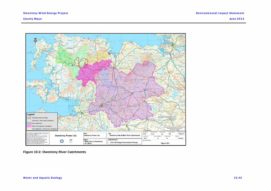
Oweninny Wind Energy Project
County Mayo
Environmental Impact Statement
June 2013
Figure 10-2: Oweninny River Catchments
Water and Aquatic Ecology 10.42

Oweninny Wind Energy Project
County Mayo
Environmental Impact Statement
June 2013
Figure 10-3: Electrofishing survey assessment locations
Water and Aquatic Ecology 10.43
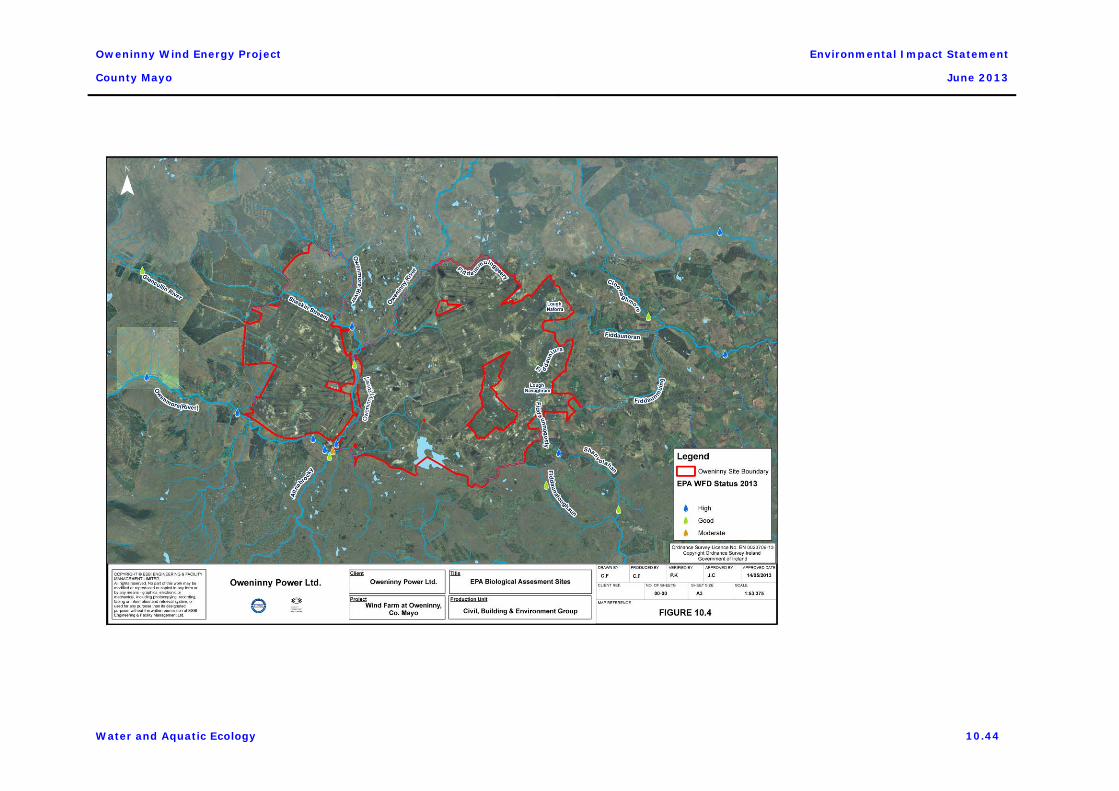
Oweninny Wind Energy Project
County Mayo
Environmental Impact Statement
June 2013
Water and Aquatic Ecology 10.44

Oweninny Wind Energy Project
County Mayo
Environmental Impact Statement
June 2013
Figure 10-4: EPA Biological Assessment Sites
Water and Aquatic Ecology 10.45

Oweninny Wind Energy Project
County Mayo
Environmental Impact Statement
June 2013
Figure 10-5: Aquafact Biological Water Quality monitoring sites
Water and Aquatic Ecology 10.46

Oweninny Wind Energy Project
County Mayo
Environmental Impact Statement
June 2013
Figure 10-6: Location of Freshwater Pearl Mussel recorded populations on the Deel river
Water and Aquatic Ecology 10.47

Oweninny Wind Energy Project
County Mayo
Environmental Impact Statement
June 2013
Water and Aquatic Ecology 10.48
Figure 10-7: Lough Dahybaun catchment