Embed Size (px)
Citation preview

appendix a: the emerging design + deliverability brief

C
Appendix A: The Design + Deliverability Brief
CONTENTS
INTRODUCTION A1
Purpose of the Design + Deliverability Brief A1
THE PORT AUTHORITY BUS TERMINAL A1
1 1 The Bus Terminal A1
1 2 History A2
1 3 The Bus Terminal Today: Physical and Operational Challenges A4
1 4 Growing Demand: 2040 Bus and Passenger Capacity Needs A6
1 5 A New Bus Terminal for a New Century A9
THE COMPETITION SITE AND ITS CONTEXT A13
2 1 The Site A13
2 2 Existing Conditions with Future Hudson Boulevard Development A14
2 3 Port-Authority-Owned Properties in the Vicinity of the Bus Terminal A15
2 4 Urban Design Conditions A16
MASTER PLANNING EFFORTS: THE CONCEPTS A25
3 1 Introduction to the Concepts A25
3 2 Concept 1 A34
3 3 Concept 2 A36
3 4 Concept 3 A38
3 5 Concept 4 A40
3 6 Concept 5 A42
3 7 Comparison of Concepts 1-5 A44

������������

������������

A1
Appendix A: The Design + Deliverability Brief
INTRODUCTION
Purpose of the Design + Deliverability Brief
The purpose of this emerging Design + Deliverability Brief is twofold: (1) to provide Competitors with an overview of the Port Authority Bus Terminal (the “Bus Terminal”) and the challenges the facility faces in the present and future; and (2) to describe the midtown bus master planning process (the “MBMP”) and efforts that the Port Authority has undertaken to date. Competitors should review the emerging Design + Deliverability Brief to expedite their understanding of the various concepts that the Port Authority has considered to date for the design and construction of a new bus terminal.
THE PORT AUTHORITY BUS TERMINAL
1.1. The Bus Terminal
The Bus Terminal, located in New York City (the “City”), is among the busiest intermodal transit facilities in the region. It supports daily commuter service, affordable intercity travel, and local tourism, and is a vital component of the trans-Hudson regional transportation network. The Bus Terminal is the largest and busiest facility of its kind in the world, and demand for its services is growing. On an average weekday, it serves approximately 7,800 buses and 232,000 passengers. The Lincoln Tunnel provides the NJ access route to the Bus Terminal and serves more than 93,000 peak-period weekday bus commuters, more than any other trans-Hudson transit mode, including today’s commuter rail services to New York Penn Station. In the peak morning hour, more passengers travel by bus through the Lincoln Tunnel to Manhattan’s Central Business District than on any individual NYC subway line.
More than just a bus facility, the Bus Terminal is one of New York City’s preeminent intermodal facilities by virtue of its location, directly connected to the Lincoln Tunnel, 11 subway lines, five City transit bus lines, and unparalleled pedestrian access to Manhattan’s densest office locations, the theater district, and shopping and entertainment centers. The existing interstate
figure 1–1: the port authority bus terminal today
A2
Port Authority Bus Terminal
commuter bus system is an essential trans-Hudson transit link for commuters to Midtown, supporting a flexible and growing network of services. These services rely on interconnected infrastructure comprised of the contra-flow Exclusive Bus Lane (the “XBL”) on NJ Route 495, dedicated bus lanes in the Lincoln Tunnel, and direct ramps and street-level connections between the Lincoln Tunnel and the Bus Terminal in Manhattan, and configurable New York roadways for handling Lincoln Tunnel traffic.
The Bus Terminal occupies approximately one and one-half city blocks between West 40th and West 42nd Streets and between Eighth and Ninth Avenues in midtown Manhattan, one block west of Times Square. It is approximately 800 feet long with approximately 450 feet of frontage on Eighth Avenue. The Bus Terminal’s South Wing occupies the City block between West 40th and West 41st Streets from Eighth to Ninth Avenues, and accommodates all the vehicular entrances and exits to the Bus Terminal. The North Wing occupies a half of a city block, fronting on Eighth Avenue between West 41st and West 42nd Streets. The Bus Terminal has two passenger entry and egress levels at the subway and street levels and the second floor passenger mixing and distribution level. The Bus Terminal is configured with three bus operating levels, and three automobile parking levels. The two upper bus levels have direct off-street ramp connections to the Lincoln Tunnel and the lower bus level has access to the Lincoln Tunnel via a connecting tunnel under Ninth Avenue. Each level of the North Wing, with the exception of the ground floor, extends over or under West 41st Street to connect directly with its counterpart level in the South Wing. The foundation of the North Wing, which was completed in 1981, was constructed to permit the development of a high-rise building in the air space above the North Wing.
1.2. History
The history of the Bus Terminal began in 1939, when growing interstate bus traffic was causing chaos in New York City. Buses would drive to and from eight separate bus terminals scattered throughout Midtown. Congestion was a major problem, and the City needed a good solution. Mayor Fiorello LaGuardia appointed a committee of City officials to resolve the issue. The
committee arrived at several solutions, which were quickly rejected by the City’s smaller bus terminals. In response, the Mayor asked The Port Authority of New York and New Jersey, established in 1921, to promote and protect the commerce of the bistate region, to evaluate the concept of consolidating all smaller bus stations into one central terminal. Late in 1946, Mayor William O’Dwyer supported legislation that prohibited the proliferation of individual bus stations in Midtown Manhattan. This resolution enabled the Port Authority to construct a Midtown bus terminal that would soon occupy an entire city block and elevate the efficiency of bus operations to a level unparalleled in the country and the world.
figure 1–2: w42nd street and eighth avenue circa 1940s
A3
Appendix A: The Design + Deliverability Brief
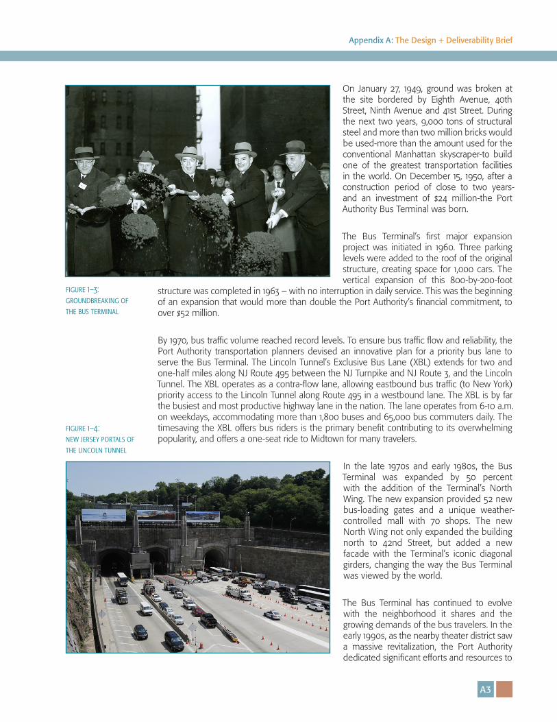
On January 27, 1949, ground was broken at the site bordered by Eighth Avenue, 40th Street, Ninth Avenue and 41st Street. During the next two years, 9,000 tons of structural steel and more than two million bricks would be used-more than the amount used for the conventional Manhattan skyscraper-to build one of the greatest transportation facilities in the world. On December 15, 1950, after a construction period of close to two years-and an investment of $24 million-the Port Authority Bus Terminal was born.
The Bus Terminal’s first major expansion project was initiated in 1960. Three parking levels were added to the roof of the original structure, creating space for 1,000 cars. The vertical expansion of this 800-by-200-foot
structure was completed in 1963 – with no interruption in daily service. This was the beginning of an expansion that would more than double the Port Authority’s financial commitment, to over $52 million.
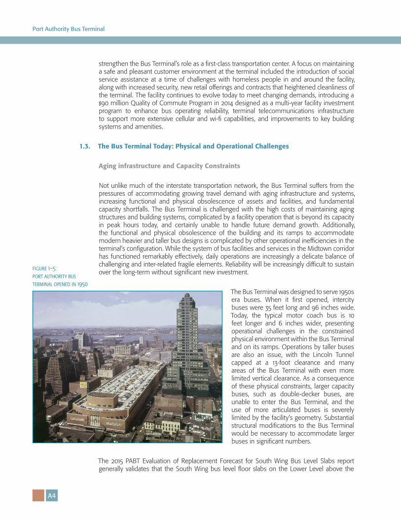
By 1970, bus traffic volume reached record levels. To ensure bus traffic flow and reliability, the Port Authority transportation planners devised an innovative plan for a priority bus lane to serve the Bus Terminal. The Lincoln Tunnel’s Exclusive Bus Lane (XBL) extends for two and one-half miles along NJ Route 495 between the NJ Turnpike and NJ Route 3, and the Lincoln Tunnel. The XBL operates as a contra-flow lane, allowing eastbound bus traffic (to New York) priority access to the Lincoln Tunnel along Route 495 in a westbound lane. The XBL is by far the busiest and most productive highway lane in the nation. The lane operates from 6-10 a.m. on weekdays, accommodating more than 1,800 buses and 65,000 bus commuters daily. The timesaving the XBL offers bus riders is the primary benefit contributing to its overwhelming popularity, and offers a one-seat ride to Midtown for many travelers.
In the late 1970s and early 1980s, the Bus Terminal was expanded by 50 percent with the addition of the Terminal’s North Wing. The new expansion provided 52 new bus-loading gates and a unique weather-controlled mall with 70 shops. The new North Wing not only expanded the building north to 42nd Street, but added a new facade with the Terminal’s iconic diagonal girders, changing the way the Bus Terminal was viewed by the world.
The Bus Terminal has continued to evolve with the neighborhood it shares and the growing demands of the bus travelers. In the early 1990s, as the nearby theater district saw a massive revitalization, the Port Authority dedicated significant efforts and resources to
figure 1–3: groundbreaking of the bus terminal
figure 1–4: new jersey portals of the lincoln tunnel
A4
Port Authority Bus Terminal
strengthen the Bus Terminal’s role as a first-class transportation center. A focus on maintaining a safe and pleasant customer environment at the terminal included the introduction of social service assistance at a time of challenges with homeless people in and around the facility, along with increased security, new retail offerings and contracts that heightened cleanliness of the terminal. The facility continues to evolve today to meet changing demands, introducing a $90 million Quality of Commute Program in 2014 designed as a multi-year facility investment program to enhance bus operating reliability, terminal telecommunications infrastructure to support more extensive cellular and wi-fi capabilities, and improvements to key building systems and amenities.
1.3. The Bus Terminal Today: Physical and Operational Challenges
Aging infrastructure and Capacity Constraints
Not unlike much of the interstate transportation network, the Bus Terminal suffers from the pressures of accommodating growing travel demand with aging infrastructure and systems, increasing functional and physical obsolescence of assets and facilities, and fundamental capacity shortfalls. The Bus Terminal is challenged with the high costs of maintaining aging structures and building systems, complicated by a facility operation that is beyond its capacity in peak hours today, and certainly unable to handle future demand growth. Additionally, the functional and physical obsolescence of the building and its ramps to accommodate modern heavier and taller bus designs is complicated by other operational inefficiencies in the terminal’s configuration. While the system of bus facilities and services in the Midtown corridor has functioned remarkably effectively, daily operations are increasingly a delicate balance of challenging and inter-related fragile elements. Reliability will be increasingly difficult to sustain over the long-term without significant new investment.
The Bus Terminal was designed to serve 1950s era buses. When it first opened, intercity buses were 35 feet long and 96 inches wide. Today, the typical motor coach bus is 10 feet longer and 6 inches wider, presenting operational challenges in the constrained physical environment within the Bus Terminal and on its ramps. Operations by taller buses are also an issue, with the Lincoln Tunnel capped at a 13-foot clearance and many areas of the Bus Terminal with even more limited vertical clearance. As a consequence of these physical constraints, larger capacity buses, such as double-decker buses, are unable to enter the Bus Terminal, and the use of more articulated buses is severely limited by the facility’s geometry. Substantial structural modifications to the Bus Terminal would be necessary to accommodate larger buses in significant numbers.
The 2015 PABT Evaluation of Replacement Forecast for South Wing Bus Level Slabs report generally validates that the South Wing bus level floor slabs on the Lower Level above the
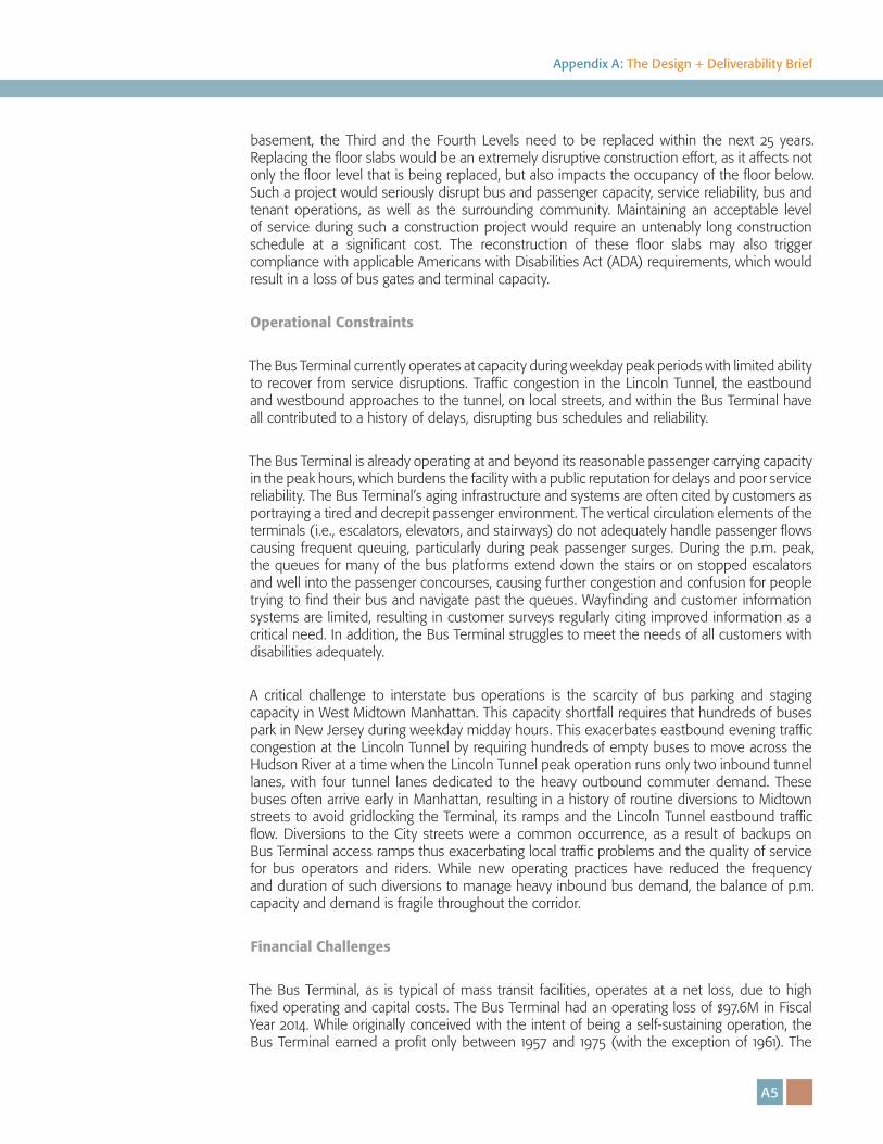
figure 1–5: port authority bus terminal opened in 1950
A5
Appendix A: The Design + Deliverability Brief
basement, the Third and the Fourth Levels need to be replaced within the next 25 years. Replacing the floor slabs would be an extremely disruptive construction effort, as it affects not only the floor level that is being replaced, but also impacts the occupancy of the floor below. Such a project would seriously disrupt bus and passenger capacity, service reliability, bus and tenant operations, as well as the surrounding community. Maintaining an acceptable level of service during such a construction project would require an untenably long construction schedule at a significant cost. The reconstruction of these floor slabs may also trigger compliance with applicable Americans with Disabilities Act (ADA) requirements, which would result in a loss of bus gates and terminal capacity.
Operational Constraints
The Bus Terminal currently operates at capacity during weekday peak periods with limited ability to recover from service disruptions. Traffic congestion in the Lincoln Tunnel, the eastbound and westbound approaches to the tunnel, on local streets, and within the Bus Terminal have all contributed to a history of delays, disrupting bus schedules and reliability.
The Bus Terminal is already operating at and beyond its reasonable passenger carrying capacity in the peak hours, which burdens the facility with a public reputation for delays and poor service reliability. The Bus Terminal’s aging infrastructure and systems are often cited by customers as portraying a tired and decrepit passenger environment. The vertical circulation elements of the terminals (i.e., escalators, elevators, and stairways) do not adequately handle passenger flows causing frequent queuing, particularly during peak passenger surges. During the p.m. peak, the queues for many of the bus platforms extend down the stairs or on stopped escalators and well into the passenger concourses, causing further congestion and confusion for people trying to find their bus and navigate past the queues. Wayfinding and customer information systems are limited, resulting in customer surveys regularly citing improved information as a critical need. In addition, the Bus Terminal struggles to meet the needs of all customers with disabilities adequately.
A critical challenge to interstate bus operations is the scarcity of bus parking and staging capacity in West Midtown Manhattan. This capacity shortfall requires that hundreds of buses park in New Jersey during weekday midday hours. This exacerbates eastbound evening traffic congestion at the Lincoln Tunnel by requiring hundreds of empty buses to move across the Hudson River at a time when the Lincoln Tunnel peak operation runs only two inbound tunnel lanes, with four tunnel lanes dedicated to the heavy outbound commuter demand. These buses often arrive early in Manhattan, resulting in a history of routine diversions to Midtown streets to avoid gridlocking the Terminal, its ramps and the Lincoln Tunnel eastbound traffic flow. Diversions to the City streets were a common occurrence, as a result of backups on Bus Terminal access ramps thus exacerbating local traffic problems and the quality of service for bus operators and riders. While new operating practices have reduced the frequency and duration of such diversions to manage heavy inbound bus demand, the balance of p.m. capacity and demand is fragile throughout the corridor.
Financial Challenges
The Bus Terminal, as is typical of mass transit facilities, operates at a net loss, due to high fixed operating and capital costs. The Bus Terminal had an operating loss of $97.6M in Fiscal Year 2014. While originally conceived with the intent of being a self-sustaining operation, the Bus Terminal earned a profit only between 1957 and 1975 (with the exception of 1961). The
A6
Port Authority Bus Terminal
Bus Terminal’s revenues are primarily from departure fees that are assessed on each bus. Additional revenue is provided by retail, advertising, and parking.
1.4. Growing Demand: 2040 Bus and Passenger Capacity Needs
The future size and configuration of the Bus Terminal will be driven by the projected growth in bus ridership and forecasted peak demand on an average weekday, and the need for a flexible operating environment that may be scalable and able to be programmed based on future technological changes and advancements.
Today’s Demand Characteristics
The past four decades have seen substantial growth in travel between Manhattan and New Jersey. Today, over one million passengers per day cross the Hudson River between 60th Street and the Battery (see Figure 1–6). Buses are the workhorses of trans-Hudson travel, carrying 37% of passengers in and out of the Central Business District across the Hudson River.
The interstate bus network also provides a vital level of resiliency in maintaining trans-Hudson connections to and from Manhattan when extreme weather, flooding, and other events assault the region’s transportation infrastructure, and especially its vulnerable rail tunnels. The ability to sustain and expand trans-Hudson bus service more quickly than commuter rail or PATH service was demonstrated by the recent experience of Superstorm Sandy, underscoring the greater flexibility of the roadway network and bus transit system. Additional bus runs to and from the Bus Terminal and curbside locations provide a commuting alternative for displaced NJ Transit rail and PATH riders.
Trans-Hudson buses serve many different travel markets, including local transit, commuter, intercity, tour, charter, and airport shuttle buses. The Bus Terminal plays a vital role in serving many of these markets. It hosts routes serving daily commuters throughout New Jersey, Eastern Pennsylvania, and the Lower Hudson Valley. It also hosts routes that provide frequent intercity services to and from locations such as upstate New York, Virginia, and Canada, with daily services to destinations much further afield. Overall, about 61% of bus passengers crossing the Hudson below 60th Street in Manhattan pass through the Bus Terminal, with the remainder entering or exiting their buses on city streets. The Bus Terminal serves an estimated 232,000 passengers on a typical weekday.
For the purposes of planning for a new Bus Terminal, routes that tend to have pronounced service peaks during the a.m. and p.m. rush hours have been designated “commuter routes.”
figure 1–6: historic trends in trans-hudson travel by mode
A7
Appendix A: The Design + Deliverability Brief
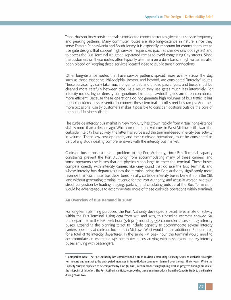
Trans-Hudson jitney services are also considered commuter routes, given their service frequency and peaking patterns. Many commuter routes are also long-distance in nature, since they serve Eastern Pennsylvania and South Jersey. It is especially important for commuter routes to use gate designs that support high service frequencies (such as shallow sawtooth gates) and to access the Bus Terminal via grade-separated ramps to avoid congesting City streets. Since the customers on these routes often typically use them on a daily basis, a high value has also been placed on keeping these services located close to public transit connections.
Other long-distance routes that have service patterns spread more evenly across the day, such as those that serve Philadelphia, Boston, and beyond, are considered “intercity” routes. These services typically take much longer to load and unload passengers, and buses must be cleaned more carefully between trips. As a result, they use gates much less intensively. For intercity routes, higher-density configurations like deep sawtooth gates are often considered more efficient. Because these operations do not generate high volumes of bus traffic, it has been considered less essential to connect these terminals to off-street bus ramps. And their more occasional use by customers makes it possible to consider locations outside the core of the central business district.
The curbside intercity bus market in New York City has grown rapidly from virtual nonexistence slightly more than a decade ago. While commuter bus volumes in West Midtown still dwarf the curbside intercity bus activity, the latter has surpassed the terminal-based intercity bus activity in volume. These low cost operators, and their curbside operations, must be considered as part of any study dealing comprehensively with the intercity bus market.
Curbside buses pose a unique problem to the Port Authority, since Bus Terminal capacity constraints prevent the Port Authority from accommodating many of these carriers, and some operators use buses that are physically too large to enter the terminal. These buses compete directly with intercity carriers like Greyhound that do use the Bus Terminal, and whose intercity bus departures from the terminal bring the Port Authority significantly more revenue than commuter bus departures. Finally, curbside intercity buses benefit from the XBL lane without generating terminal revenue for the Port Authority, and actually worsen Midtown street congestion by loading, staging, parking, and circulating outside of the Bus Terminal. It would be advantageous to accommodate more of these curbside operations within terminals.
An Overview of Bus Demand in 20401
For long-term planning purposes, the Port Authority developed a baseline estimate of activity within the Bus Terminal. Using data from 2011 and 2012, this baseline estimate showed 615 bus departures in the PM peak hour (5-6 pm), including 592 commuter buses and 23 intercity buses. Expanding the planning target to include capacity to accommodate several intercity carriers operating at curbside locations in Midtown West would add an additional 16 departures, for a total of 39 intercity departures. In the same PM peak hour, the terminal would need to accommodate an estimated 142 commuter buses arriving with passengers and 25 intercity buses arriving with passengers.
1 Competitor Note: The Port Authority has commissioned a trans-Hudson Commuting Capacity Study of available strategies
for meeting and managing the anticipated increases in trans-Hudson commuter demand over the next thirty years. While the
Capacity Study is expected to be completed by June 30, 2016, interim products highlighting work-in-progress findings are due at
the midpoint of this effort. The Port Authority anticipates providing these interim products from the Capacity Study to the Finalists
during Phase Two.

A8
Port Authority Bus Terminal
The Port Authority developed forecasts for the entire trans-Hudson and intercity travel market based on regional travel demand forecasts and survey data. These forecasts indicate a 51.7% increase in PM peak hour bus passenger departures by 2040. An operational analysis, including estimates of available capacity on existing bus service, concluded that a 39% increase in PM peak hour bus departures would be required to serve these passengers.
Based on this analysis, the new bus terminal should be able to accommodate 820 departing and 143 arriving commuter buses in the PM peak hour, as well as 57 departing intercity buses and 31 arriving intercity buses. These results are summarized in the following tables:
MBMP Planning Forecast: PM Peak Hour Arrivals, 5-6 pm
2011/12 2040
Buses Passengers Buses Passengers
Port Authority Bus Terminal – Existing Markets
156 2,125 158 2,696
New Jersey Transit 100 1,244 101 1,399
Other W of Hudson Commuter Buses 26 325 25 414
Intercity Buses 14 437 15 750
Jitney Buses 16 119 16 133
Midtown Curbside Intercity – Major Carriers
11 540 16 928
Target for Capacity Planning - Commuter
142 1,688 143 1,945
Target for Capacity Planning - Intercity
25 977 31 1,678
Target for Capacity Planning - Total 167 2,665 174 3,624
table 1–1: mbmp planning forecast: pm peak hour arrivals, 5-6 pm
A9
Appendix A: The Design + Deliverability Brief
1.5. A New Bus Terminal for a New Century
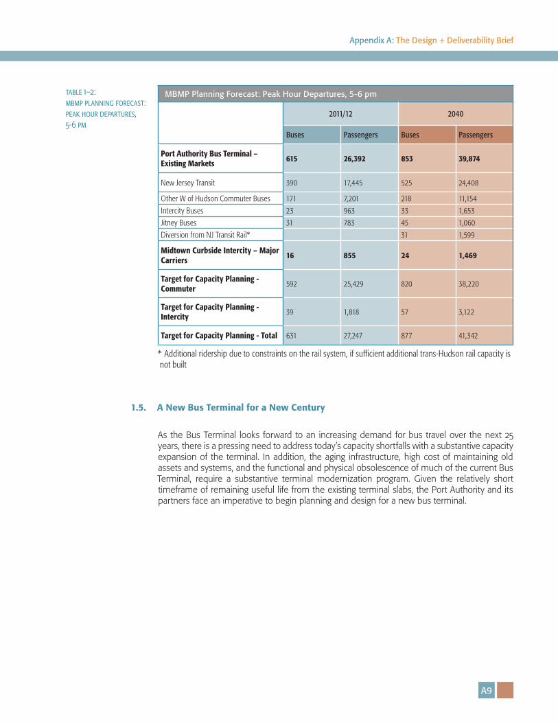
As the Bus Terminal looks forward to an increasing demand for bus travel over the next 25 years, there is a pressing need to address today’s capacity shortfalls with a substantive capacity expansion of the terminal. In addition, the aging infrastructure, high cost of maintaining old assets and systems, and the functional and physical obsolescence of much of the current Bus Terminal, require a substantive terminal modernization program. Given the relatively short timeframe of remaining useful life from the existing terminal slabs, the Port Authority and its partners face an imperative to begin planning and design for a new bus terminal.
table 1–2: mbmp planning forecast: peak hour departures, 5-6 pm
MBMP Planning Forecast: Peak Hour Departures, 5-6 pm
2011/12 2040
Buses Passengers Buses Passengers
Port Authority Bus Terminal – Existing Markets
615 26,392 853 39,874
New Jersey Transit 390 17,445 525 24,408
Other W of Hudson Commuter Buses 171 7,201 218 11,154
Intercity Buses 23 963 33 1,653
Jitney Buses 31 783 45 1,060
Diversion from NJ Transit Rail* 31 1,599
Midtown Curbside Intercity – Major Carriers
16 855 24 1,469
Target for Capacity Planning - Commuter
592 25,429 820 38,220
Target for Capacity Planning - Intercity
39 1,818 57 3,122
Target for Capacity Planning - Total 631 27,247 877 41,342
* Additional ridership due to constraints on the rail system, if sufficient additional trans-Hudson rail capacity is not built

��� ������ �� ������� ��� �� � ������ �
��� ������ �� ������� ��� �� � ������ �

A12
Port Authority Bus Terminal
A13
Appendix A: The Design + Deliverability Brief
The Competition Site and its Context
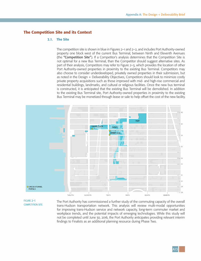
2.1. The Site
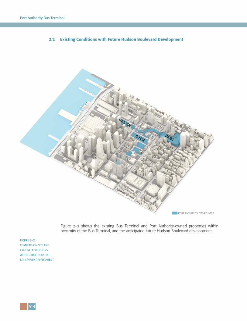
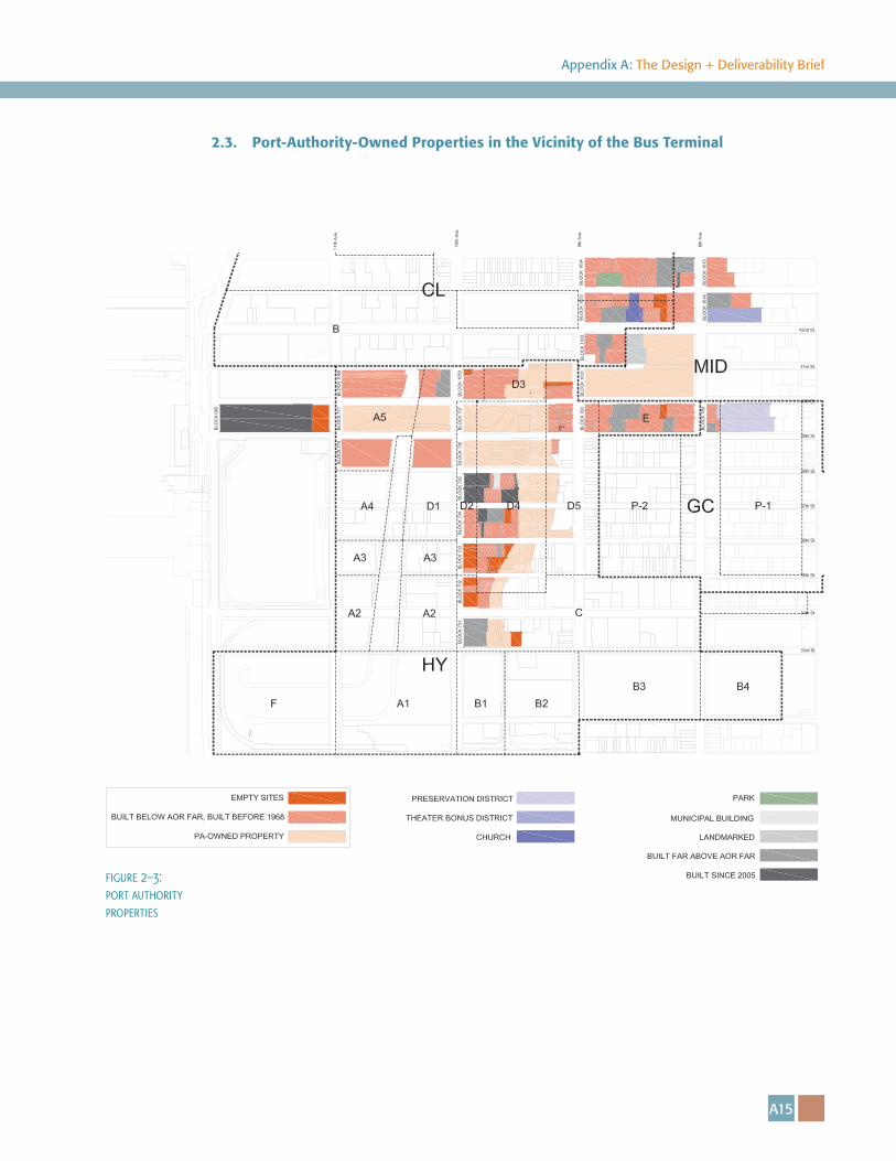
The competition site is shown in blue in Figures 2–1 and 2–2, and includes Port Authority-owned property one block west of the current Bus Terminal, between Ninth and Eleventh Avenues (the “Competition Site”). If a Competitor’s analysis determines that the Competition Site is not optimal for a new Bus Terminal, than the Competitor should suggest alternative sites. As part of their analysis, Competitors may refer to Figure 2–3, which provides the location of other Port Authority-owned properties in proximity to the existing Bus Terminal. Competitors may also choose to consider underdeveloped, privately owned properties in their submission, but as noted in the Design + Deliverability Objectives, Competitors should look to minimize costly private property acquisitions such as those improved with mid- and high-rise commercial and residential buildings, landmarks, and cultural or religious facilities. Once the new bus terminal is constructed, it is anticipated that the existing Bus Terminal will be demolished. In addition to the existing Bus Terminal site, Port Authority-owned properties in proximity to the existing Bus Terminal may be monetized through lease or sale to help offset the cost of the new facility.
The Port Authority has commissioned a further study of the commuting capacity of the overall trans-Hudson transportation network. This analysis will review multi-modal opportunities for improving trans-Hudson service and network capacity, long-term commuter market and workplace trends, and the potential impacts of emerging technologies. While this study will not be completed until June 30, 2016, the Port Authority anticipates providing relevant interim findings to Finalists as an additional planning resource during Phase Two.
figure 2–1: competition site
A14
Port Authority Bus Terminal
2.2 Existing Conditions with Future Hudson Boulevard Development
PABTDYER
GALVIN
PORT AUTHORITY OWNED LOTS
figure 2–2: competition site and existing conditions with future hudson boulevard development
Figure 2–2 shows the existing Bus Terminal and Port Authority-owned properties within proximity of the Bus Terminal, and the anticipated future Hudson Boulevard development.
A15
Appendix A: The Design + Deliverability Brief
2.3. Port-Authority-Owned Properties in the Vicinity of the Bus Terminal
figure 2–3: port authority properties
A16
Port Authority Bus Terminal
figure 2–4: existing pabt and midtown as viewed from the west side and future hudson boulevard
2.4. Urban Design Conditions
The Growth of Midtown West
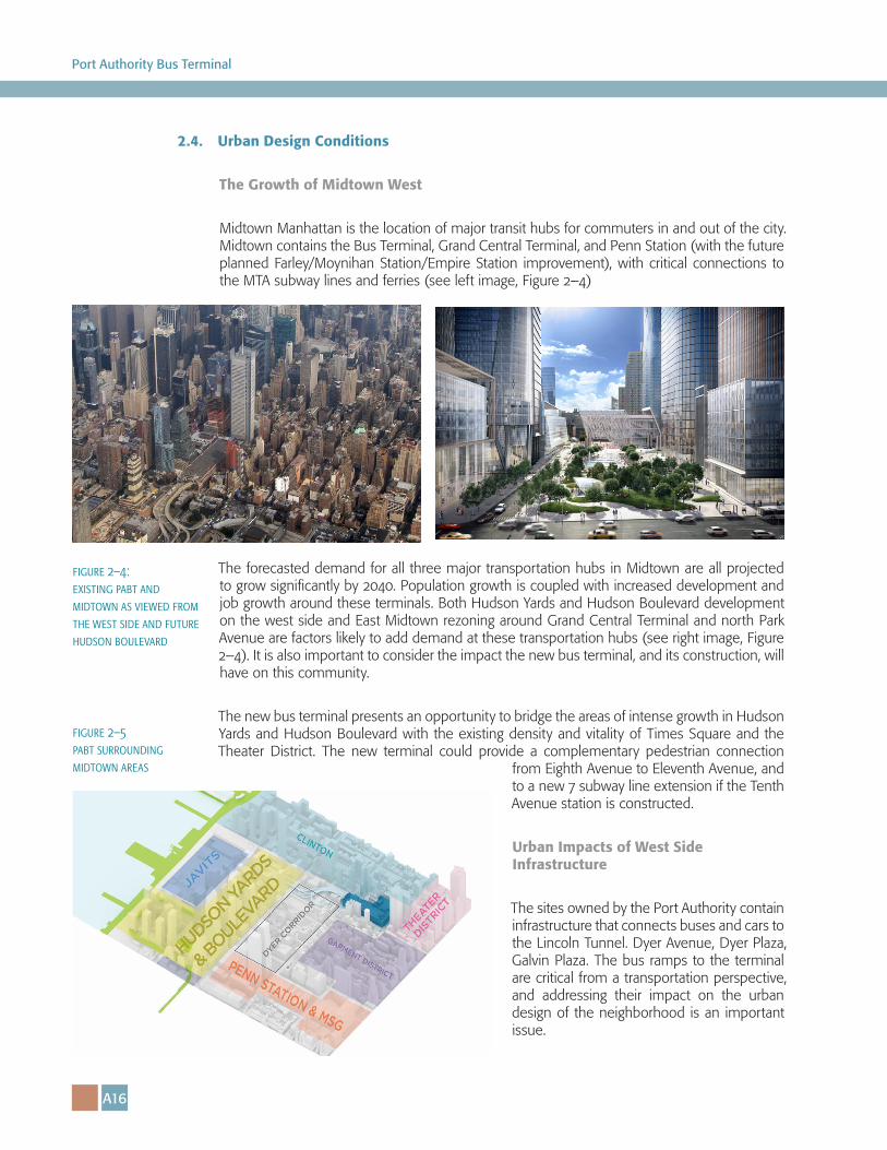
Midtown Manhattan is the location of major transit hubs for commuters in and out of the city. Midtown contains the Bus Terminal, Grand Central Terminal, and Penn Station (with the future planned Farley/Moynihan Station/Empire Station improvement), with critical connections to the MTA subway lines and ferries (see left image, Figure 2–4)
The forecasted demand for all three major transportation hubs in Midtown are all projected to grow significantly by 2040. Population growth is coupled with increased development and job growth around these terminals. Both Hudson Yards and Hudson Boulevard development on the west side and East Midtown rezoning around Grand Central Terminal and north Park Avenue are factors likely to add demand at these transportation hubs (see right image, Figure 2–4). It is also important to consider the impact the new bus terminal, and its construction, will have on this community.
The new bus terminal presents an opportunity to bridge the areas of intense growth in Hudson Yards and Hudson Boulevard with the existing density and vitality of Times Square and the Theater District. The new terminal could provide a complementary pedestrian connection
from Eighth Avenue to Eleventh Avenue, and to a new 7 subway line extension if the Tenth Avenue station is constructed.
Urban Impacts of West Side Infrastructure
The sites owned by the Port Authority contain infrastructure that connects buses and cars to the Lincoln Tunnel. Dyer Avenue, Dyer Plaza, Galvin Plaza. The bus ramps to the terminal are critical from a transportation perspective, and addressing their impact on the urban design of the neighborhood is an important issue.
figure 2–5 pabt surrounding midtown areas
A17
Appendix A: The Design + Deliverability Brief
PABT
GALVIN
DYER
THE THEATER DISTRICT
PENN STATION & MADISON SQUARE GARDEN
HIGH LINE
EXISTING PABT
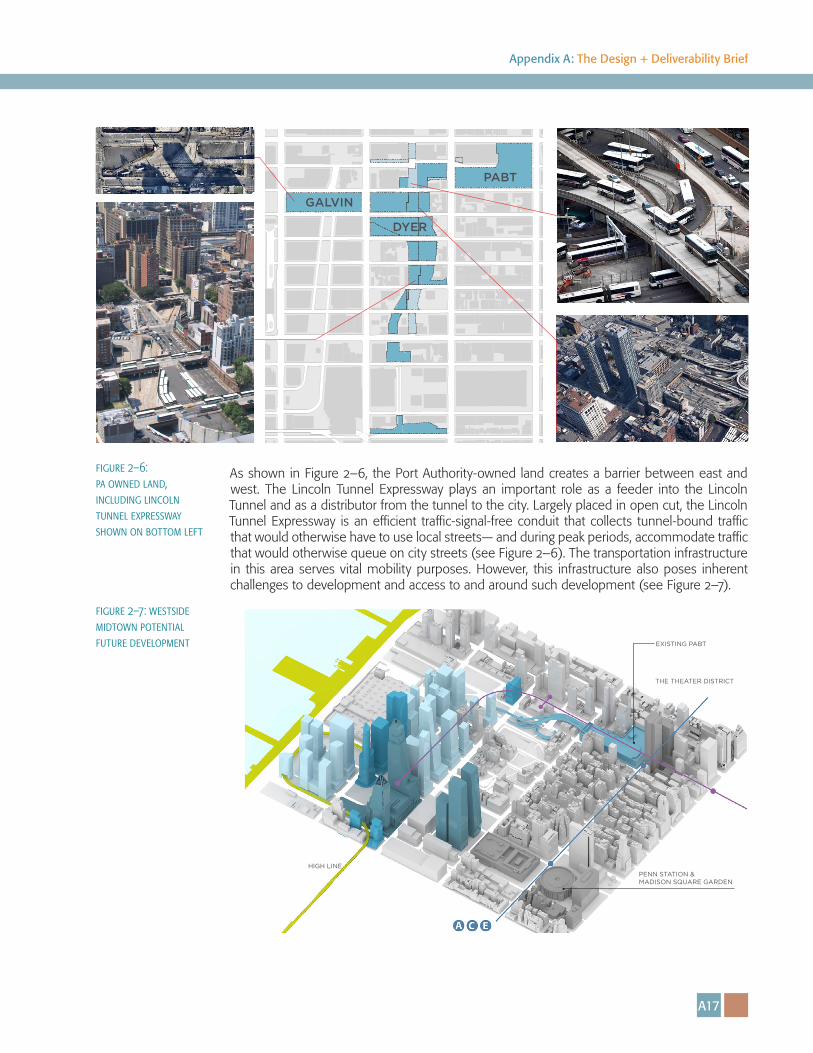
As shown in Figure 2–6, the Port Authority-owned land creates a barrier between east and west. The Lincoln Tunnel Expressway plays an important role as a feeder into the Lincoln Tunnel and as a distributor from the tunnel to the city. Largely placed in open cut, the Lincoln Tunnel Expressway is an efficient traffic-signal-free conduit that collects tunnel-bound traffic that would otherwise have to use local streets— and during peak periods, accommodate traffic that would otherwise queue on city streets (see Figure 2–6). The transportation infrastructure in this area serves vital mobility purposes. However, this infrastructure also poses inherent challenges to development and access to and around such development (see Figure 2–7).
figure 2–6: pa owned land, including lincoln tunnel expressway shown on bottom left
figure 2–7: westside midtown potential future development
A18
Port Authority Bus Terminal
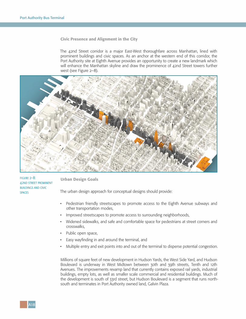
Civic Presence and Alignment in the City
The 42nd Street corridor is a major East-West thoroughfare across Manhattan, lined with prominent buildings and civic spaces. As an anchor at the western end of this corridor, the Port Authority site at Eighth Avenue provides an opportunity to create a new landmark which will enhance the Manhattan skyline and draw the prominence of 42nd Street towers further west (see Figure 2–8).
Urban Design Goals
The urban design approach for conceptual designs should provide:
• Pedestrian friendly streetscapes to promote access to the Eighth Avenue subways and other transportation modes,
• Improved streetscapes to promote access to surrounding neighborhoods,
• Widened sidewalks, and safe and comfortable space for pedestrians at street corners and crosswalks,
• Public open space,
• Easy wayfinding in and around the terminal, and
• Multiple entry and exit points into and out of the terminal to disperse potential congestion.
Millions of square feet of new development in Hudson Yards, the West Side Yard, and Hudson Boulevard is underway in West Midtown between 30th and 39th streets, Tenth and 12th Avenues. The improvements revamp land that currently contains exposed rail yards, industrial buildings, empty lots, as well as smaller scale commercial and residential buildings. Much of the development is south of 33rd street, but Hudson Boulevard is a segment that runs north-south and terminates in Port Authority owned land, Galvin Plaza.
figure 2–8: 42nd street prominent buildings and civic spaces
A19
Appendix A: The Design + Deliverability Brief
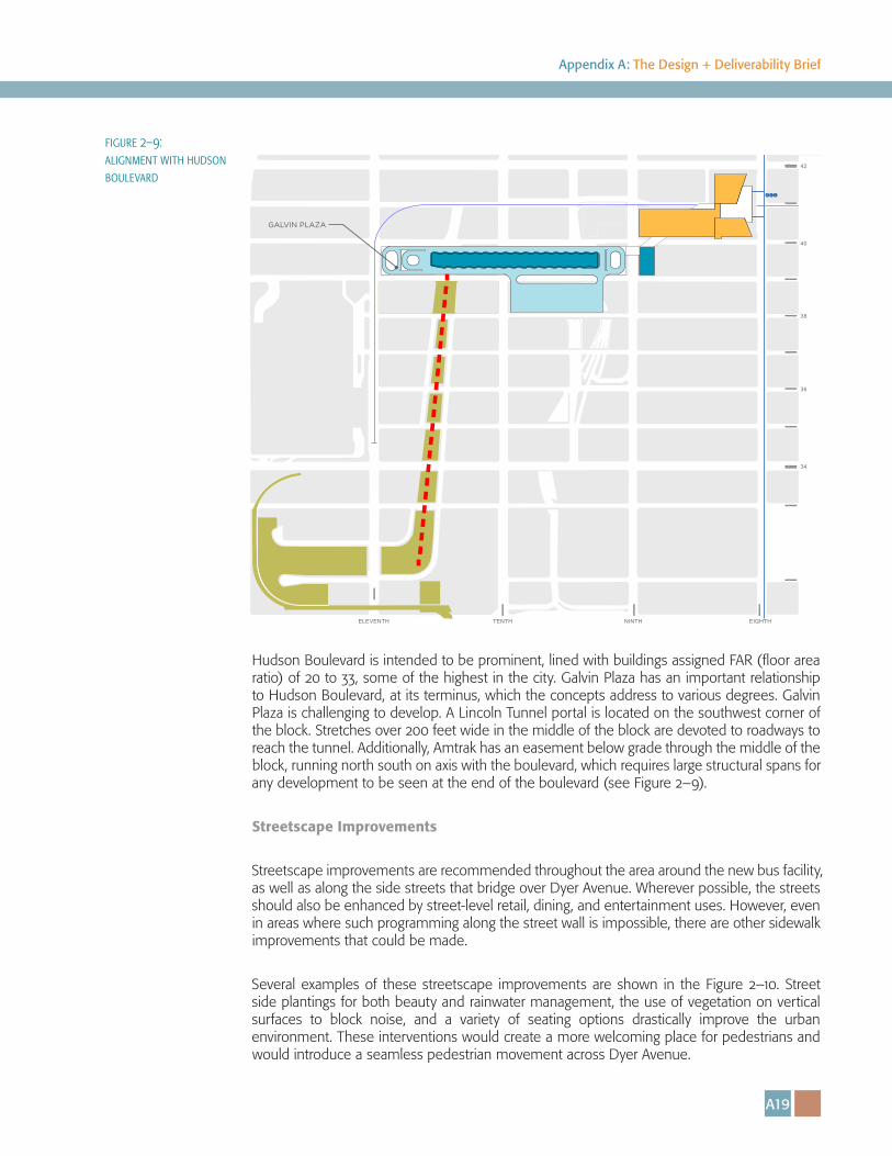
Hudson Boulevard is intended to be prominent, lined with buildings assigned FAR (floor area ratio) of 20 to 33, some of the highest in the city. Galvin Plaza has an important relationship to Hudson Boulevard, at its terminus, which the concepts address to various degrees. Galvin Plaza is challenging to develop. A Lincoln Tunnel portal is located on the southwest corner of the block. Stretches over 200 feet wide in the middle of the block are devoted to roadways to reach the tunnel. Additionally, Amtrak has an easement below grade through the middle of the block, running north south on axis with the boulevard, which requires large structural spans for any development to be seen at the end of the boulevard (see Figure 2–9).
Streetscape Improvements
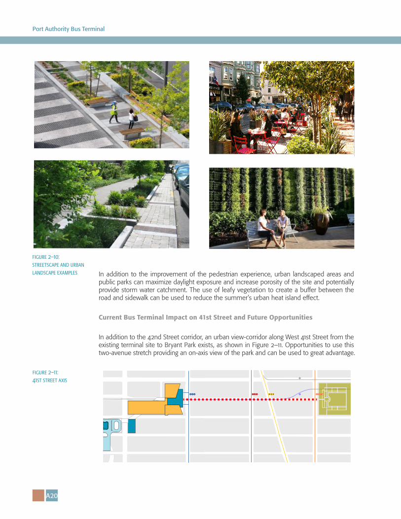
Streetscape improvements are recommended throughout the area around the new bus facility, as well as along the side streets that bridge over Dyer Avenue. Wherever possible, the streets should also be enhanced by street-level retail, dining, and entertainment uses. However, even in areas where such programming along the street wall is impossible, there are other sidewalk improvements that could be made.
Several examples of these streetscape improvements are shown in the Figure 2–10. Street side plantings for both beauty and rainwater management, the use of vegetation on vertical surfaces to block noise, and a variety of seating options drastically improve the urban environment. These interventions would create a more welcoming place for pedestrians and would introduce a seamless pedestrian movement across Dyer Avenue.
A C E
34
36
38
40
42
TENTH NINTH EIGHTHELEVENTH
GALVIN PLAZA
figure 2–9: alignment with hudson boulevard
A20
Port Authority Bus Terminal
In addition to the improvement of the pedestrian experience, urban landscaped areas and public parks can maximize daylight exposure and increase porosity of the site and potentially provide storm water catchment. The use of leafy vegetation to create a buffer between the road and sidewalk can be used to reduce the summer’s urban heat island effect.
Current Bus Terminal Impact on 41st Street and Future Opportunities
In addition to the 42nd Street corridor, an urban view-corridor along West 41st Street from the existing terminal site to Bryant Park exists, as shown in Figure 2–11. Opportunities to use this two-avenue stretch providing an on-axis view of the park and can be used to great advantage.
7A C E QN R
S
1 2 3 B D F M
figure 2–11: 41st street axis
figure 2–10: streetscape and urban landscape examples
A21
Appendix A: The Design + Deliverability Brief
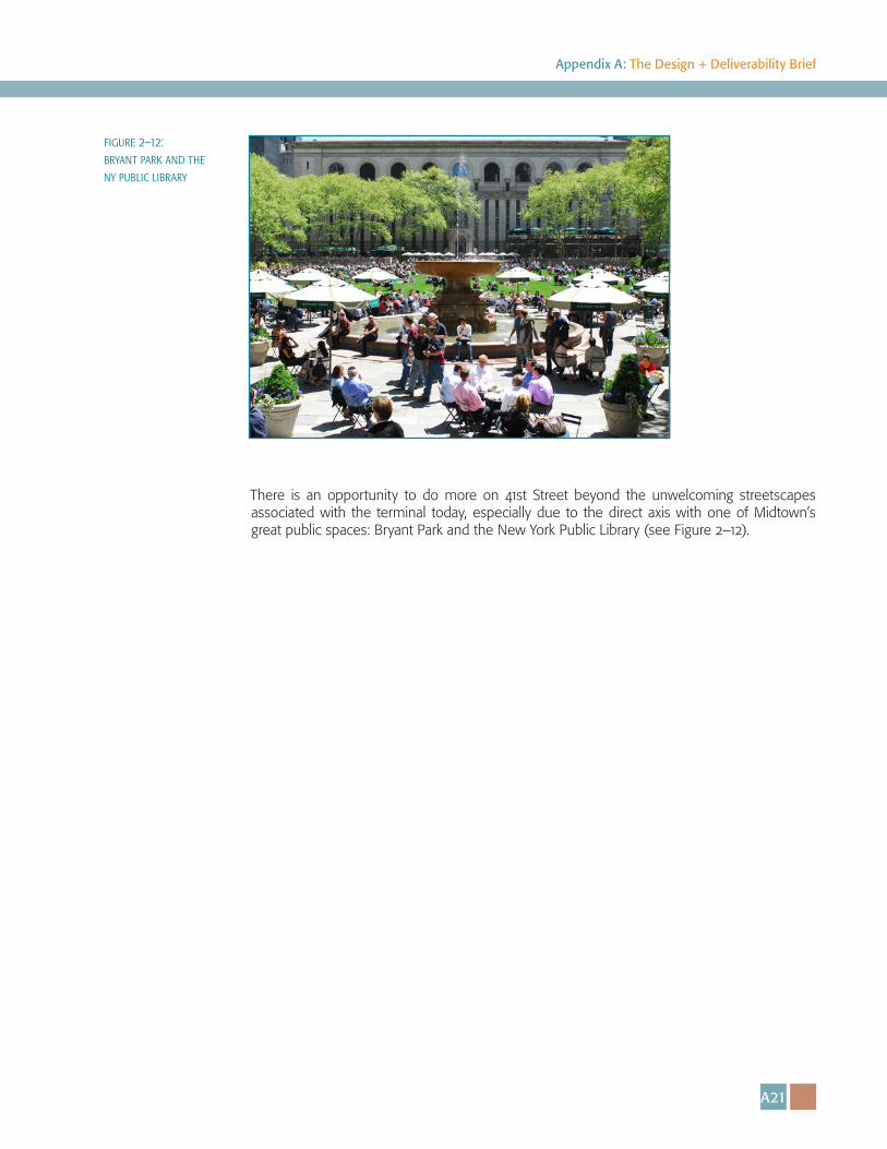
There is an opportunity to do more on 41st Street beyond the unwelcoming streetscapes associated with the terminal today, especially due to the direct axis with one of Midtown’s great public spaces: Bryant Park and the New York Public Library (see Figure 2–12).
figure 2–12: bryant park and the ny public library

������ �� ������ �������:��� ��������
������ �� ������ �������:��� ��������

A24
Port Authority Bus Terminal
A25
Appendix A: The Design + Deliverability Brief
Master Planning Efforts: The Concepts
3.1. Introduction to the Concepts
Through master planning efforts for the Bus Terminal, five concepts, introduced in this section, were advanced through the alternatives development and screening process. The alternatives development and screening process is further described in Appendix C. Competitors should review the various concepts that the Port Authority has considered to date for the design and construction of a new bus terminal to understand ongoing deliberative process behind the Port Authority’s continuing master planning efforts for the new Bus Terminal. They are not intended to represent any final determination of the Port Authority.
Competitors will note that although each of the five concepts differ in location and configuration, several features are common to more than one concept.
Some of the common elements/considerations of these concepts include:
• Bus and Passenger Circulation
• Urban Impacts of West Side Infrastructure
• Impact on Ninth Avenue
• Civic Presence and Alignment in the City
• Pedestrian Connectivity
• Interim Operations
• Intercity Bus Operations
Bus and Passenger Circulation
In each of the concepts, as buses enter Manhattan via the Lincoln Tunnel, they will enter the bus terminal comprised of ramps, a storage and staging facility, and a passenger and bus facility. Each Concept considered in the master plan features a direct connection between Lincoln Tunnel portals and the bus terminal eliminating circulation on city streets. Buses will travel via helix ramps to access either the terminal or storage and staging facility.
Ramps
In each of the concepts, three bus-only helix ramps would provide operational redundancy and flexibility. The ramping system provides terminal recirculation (as opposed to the existing Bus Terminal, which has limited, partial recirculation capacity). The helix ramps would provide critical linkages from the Lincoln Tunnel to bus storage and staging facilities; between the Lincoln Tunnel and bus gates, and between bus gates and bus storage and staging facilities that are located on different levels.
A26
Port Authority Bus Terminal
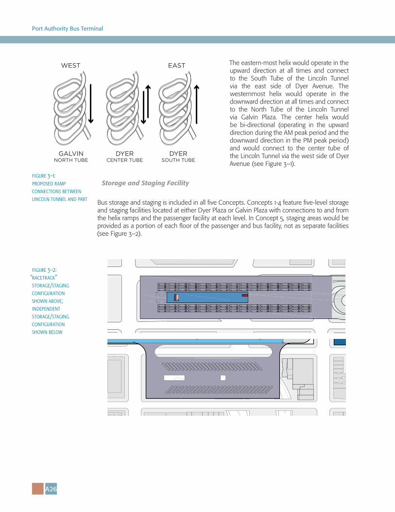
The eastern-most helix would operate in the upward direction at all times and connect to the South Tube of the Lincoln Tunnel via the east side of Dyer Avenue. The westernmost helix would operate in the downward direction at all times and connect to the North Tube of the Lincoln Tunnel via Galvin Plaza. The center helix would be bi-directional (operating in the upward direction during the AM peak period and the downward direction in the PM peak period) and would connect to the center tube of the Lincoln Tunnel via the west side of Dyer Avenue (see Figure 3–1).
Storage and Staging Facility
Bus storage and staging is included in all five Concepts. Concepts 1-4 feature five-level storage and staging facilities located at either Dyer Plaza or Galvin Plaza with connections to and from the helix ramps and the passenger facility at each level. In Concept 5, staging areas would be provided as a portion of each floor of the passenger and bus facility, not as separate facilities (see Figure 3–2).
WEST EAST
GALVINNORTH TUBE
DYERCENTER TUBE
DYERSOUTH TUBE
figure 3–1: proposed ramp connections between lincoln tunnel and pabt
figure 3–2: “racetrack” storage/staging configuration shown above; independent storage/staging configuration shown below
A27
Appendix A: The Design + Deliverability Brief
The reliability of an on-site supply of buses would improve reliability of passenger operations. The design of each floor would be flexible enough to allow for use as a storage or bus staging area with either a “racetrack” or independent storage/staging configuration.
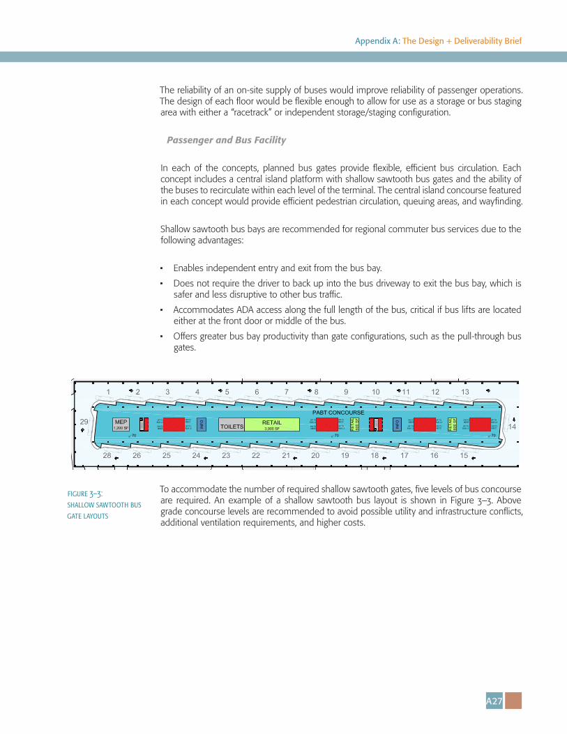
Passenger and Bus Facility
In each of the concepts, planned bus gates provide flexible, efficient bus circulation. Each concept includes a central island platform with shallow sawtooth bus gates and the ability of the buses to recirculate within each level of the terminal. The central island concourse featured in each concept would provide efficient pedestrian circulation, queuing areas, and wayfinding.
Shallow sawtooth bus bays are recommended for regional commuter bus services due to the following advantages:
• Enables independent entry and exit from the bus bay.
• Does not require the driver to back up into the bus driveway to exit the bus bay, which is safer and less disruptive to other bus traffic.
• Accommodates ADA access along the full length of the bus, critical if bus lifts are located either at the front door or middle of the bus.
• Offers greater bus bay productivity than gate configurations, such as the pull-through bus gates.
To accommodate the number of required shallow sawtooth gates, five levels of bus concourse are required. An example of a shallow sawtooth bus layout is shown in Figure 3–3. Above grade concourse levels are recommended to avoid possible utility and infrastructure conflicts, additional ventilation requirements, and higher costs.
figure 3–3: shallow sawtooth bus gate layouts
A28
Port Authority Bus Terminal
Urban Impacts of West Side Infrastructure
All of the concepts advanced through master planning efforts took into account the west side infrastructure, and the large areas occupied by these roadways, most notably those on Galvin Plaza and Dyer Plaza. Efforts were made to place terminal-related program above areas with infrastructure that already are serving vital mobility purposes. This provides cover over land that is otherwise very difficult to develop and unsightly, and also reduces the need to displace existing uses.
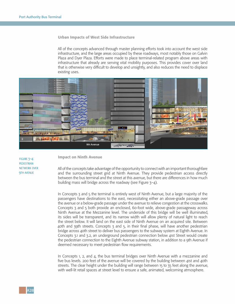
Impact on Ninth Avenue
All of the concepts take advantage of the opportunity to connect with an important thoroughfare and the surrounding street grid at Ninth Avenue. They provide pedestrian access directly between the bus terminal and the street at this avenue, but there are differences in how much building mass will bridge across the roadway (see Figure 3–4).
In Concepts 3 and 5 the terminal is entirely west of Ninth Avenue, but a large majority of the passengers have destinations to the east, necessitating either an above-grade passage over the avenue or a below-grade passage under the avenue to relieve congestion at the crosswalks. Concepts 3 and 5 both provide an enclosed, 60-foot wide, above-grade passageway across Ninth Avenue at the Mezzanine level. The underside of this bridge will be well illuminated, its sides will be transparent, and its narrow width will allow plenty of natural light to reach the street below. It will land on the east side of Ninth Avenue on an acquired site. Between 40th and 39th streets. Concepts 3 and 5, in their final phase, will have another pedestrian bridge across 40th street to deliver bus passengers to the subway system at Eighth Avenue. In Concepts 3.1 and 3.2, an underground pedestrian connection below 41st Street would create the pedestrian connection to the Eighth Avenue subway station, in addition to a 9th Avenue if deemed necessary to meet pedestrian flow requirements.
In Concepts 1, 2, and 4, the bus terminal bridges over Ninth Avenue with a mezzanine and five bus levels. 200 feet of the avenue will be covered by the building between 41st and 40th streets. The clear height under the building will range between 15 to 35 feet along the avenue, with well-lit retail spaces at street level to ensure a safe, animated, welcoming atmosphere.
figure 3–4: pedestrian network over 9th avenue
A29
Appendix A: The Design + Deliverability Brief
Civic Presence and Alignment in the City
Recognizing the opportunity to create a new landmark which will enhance the Manhattan skyline and draw the prominence of 42nd Street towers further west, all of the concepts advanced provide iconic development opportunities at the corner of Eighth Avenue and 42nd street, as well as a large civic space for passengers and surrounding communities.
Pedestrian Connectivity
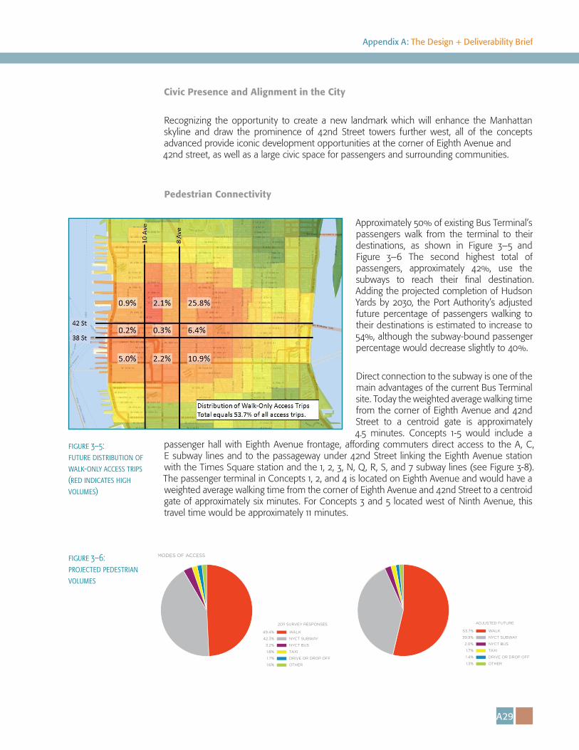
Approximately 50% of existing Bus Terminal’s passengers walk from the terminal to their destinations, as shown in Figure 3–5 and Figure 3–6 The second highest total of passengers, approximately 42%, use the subways to reach their final destination. Adding the projected completion of Hudson Yards by 2030, the Port Authority’s adjusted future percentage of passengers walking to their destinations is estimated to increase to 54%, although the subway-bound passenger percentage would decrease slightly to 40%.
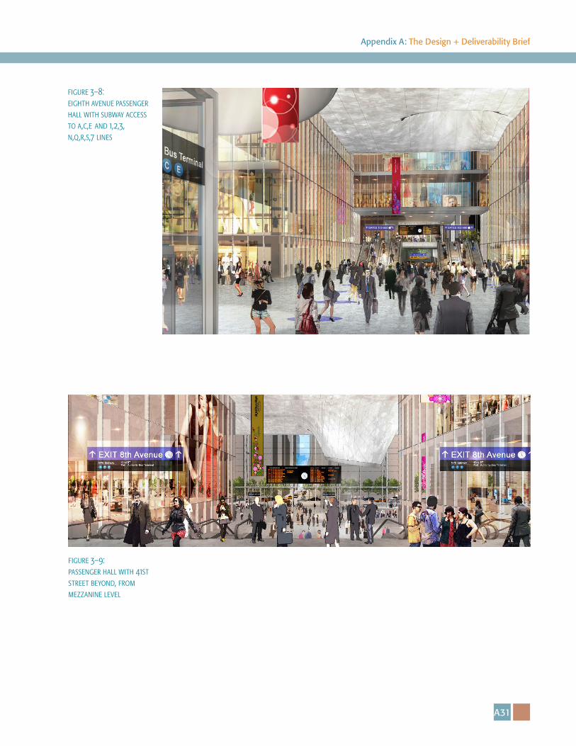
Direct connection to the subway is one of the main advantages of the current Bus Terminal site. Today the weighted average walking time from the corner of Eighth Avenue and 42nd Street to a centroid gate is approximately 4.5 minutes. Concepts 1-5 would include a
passenger hall with Eighth Avenue frontage, affording commuters direct access to the A, C, E subway lines and to the passageway under 42nd Street linking the Eighth Avenue station with the Times Square station and the 1, 2, 3, N, Q, R, S, and 7 subway lines (see Figure 3-8). The passenger terminal in Concepts 1, 2, and 4 is located on Eighth Avenue and would have a weighted average walking time from the corner of Eighth Avenue and 42nd Street to a centroid gate of approximately six minutes. For Concepts 3 and 5 located west of Ninth Avenue, this travel time would be approximately 11 minutes.
MODES OF ACCESS
2011 SURVEY RESPONSES
WALK
NYCT SUBWAY
NYCT BUS
TAXI
DRIVE OR DROP OFF
OTHER
49.4%
42.3%
3.2%
1.8%
1.7%
1.6%
ADJUSTED FUTURE
WALK
NYCT SUBWAY
NYCT BUS
TAXI
DRIVE OR DROP OFF
OTHER
53.7%
39.9%
2.0%
1.7%
1.4%
1.3%
figure 3–6: projected pedestrian volumes
figure 3–5: future distribution of walk-only access trips (red indicates high volumes)
A30
Port Authority Bus Terminal
Urban Design Considerations: Hudson Boulevard Master Plan
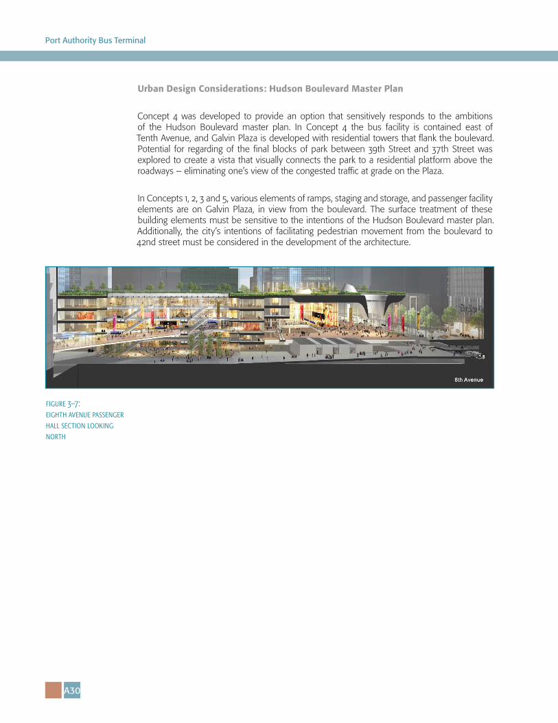
Concept 4 was developed to provide an option that sensitively responds to the ambitions of the Hudson Boulevard master plan. In Concept 4 the bus facility is contained east of Tenth Avenue, and Galvin Plaza is developed with residential towers that flank the boulevard. Potential for regarding of the final blocks of park between 39th Street and 37th Street was explored to create a vista that visually connects the park to a residential platform above the roadways – eliminating one’s view of the congested traffic at grade on the Plaza.
In Concepts 1, 2, 3 and 5, various elements of ramps, staging and storage, and passenger facility elements are on Galvin Plaza, in view from the boulevard. The surface treatment of these building elements must be sensitive to the intentions of the Hudson Boulevard master plan. Additionally, the city’s intentions of facilitating pedestrian movement from the boulevard to 42nd street must be considered in the development of the architecture.
figure 3–7: eighth avenue passenger hall section looking north
A31
Appendix A: The Design + Deliverability Brief
figure 3–8: eighth avenue passenger hall with subway access to a,c,e and 1,2,3, n,q,r,s,7 lines
figure 3–9: passenger hall with 41st street beyond, from mezzanine level
A32
Port Authority Bus Terminal
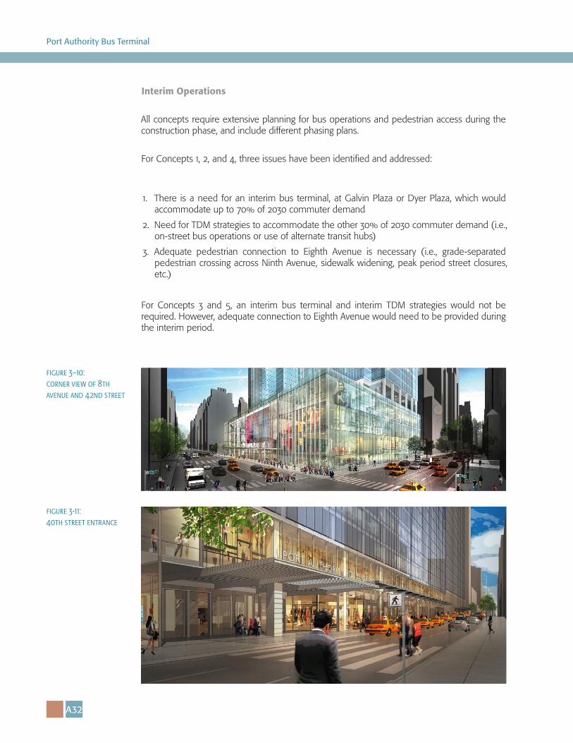
Interim Operations
All concepts require extensive planning for bus operations and pedestrian access during the construction phase, and include different phasing plans.
For Concepts 1, 2, and 4, three issues have been identified and addressed:
1. There is a need for an interim bus terminal, at Galvin Plaza or Dyer Plaza, which would
accommodate up to 70% of 2030 commuter demand
2. Need for TDM strategies to accommodate the other 30% of 2030 commuter demand (i.e., on-street bus operations or use of alternate transit hubs)
3. Adequate pedestrian connection to Eighth Avenue is necessary (i.e., grade-separated pedestrian crossing across Ninth Avenue, sidewalk widening, peak period street closures, etc.)
For Concepts 3 and 5, an interim bus terminal and interim TDM strategies would not be required. However, adequate connection to Eighth Avenue would need to be provided during the interim period.
figure 3–10: corner view of 8th avenue and 42nd street
figure 3-11: 40th street entrance
A33
Appendix A: The Design + Deliverability Brief
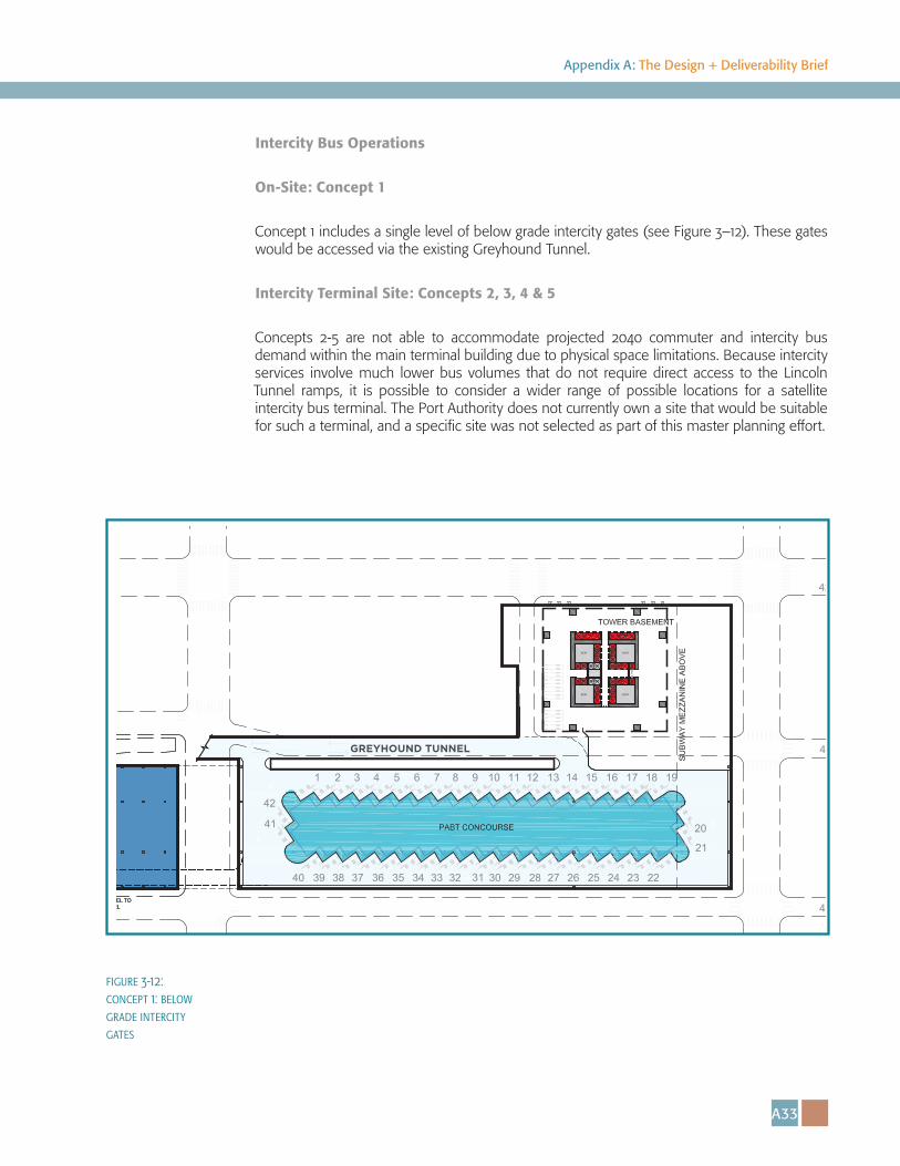
Intercity Bus Operations
On-Site: Concept 1
Concept 1 includes a single level of below grade intercity gates (see Figure 3–12). These gates would be accessed via the existing Greyhound Tunnel.
Intercity Terminal Site: Concepts 2, 3, 4 & 5
Concepts 2-5 are not able to accommodate projected 2040 commuter and intercity bus demand within the main terminal building due to physical space limitations. Because intercity services involve much lower bus volumes that do not require direct access to the Lincoln Tunnel ramps, it is possible to consider a wider range of possible locations for a satellite intercity bus terminal. The Port Authority does not currently own a site that would be suitable for such a terminal, and a specific site was not selected as part of this master planning effort.
GREYHOUND TUNNEL
figure 3-12: concept 1: below grade intercity gates
A34
Port Authority Bus Terminal
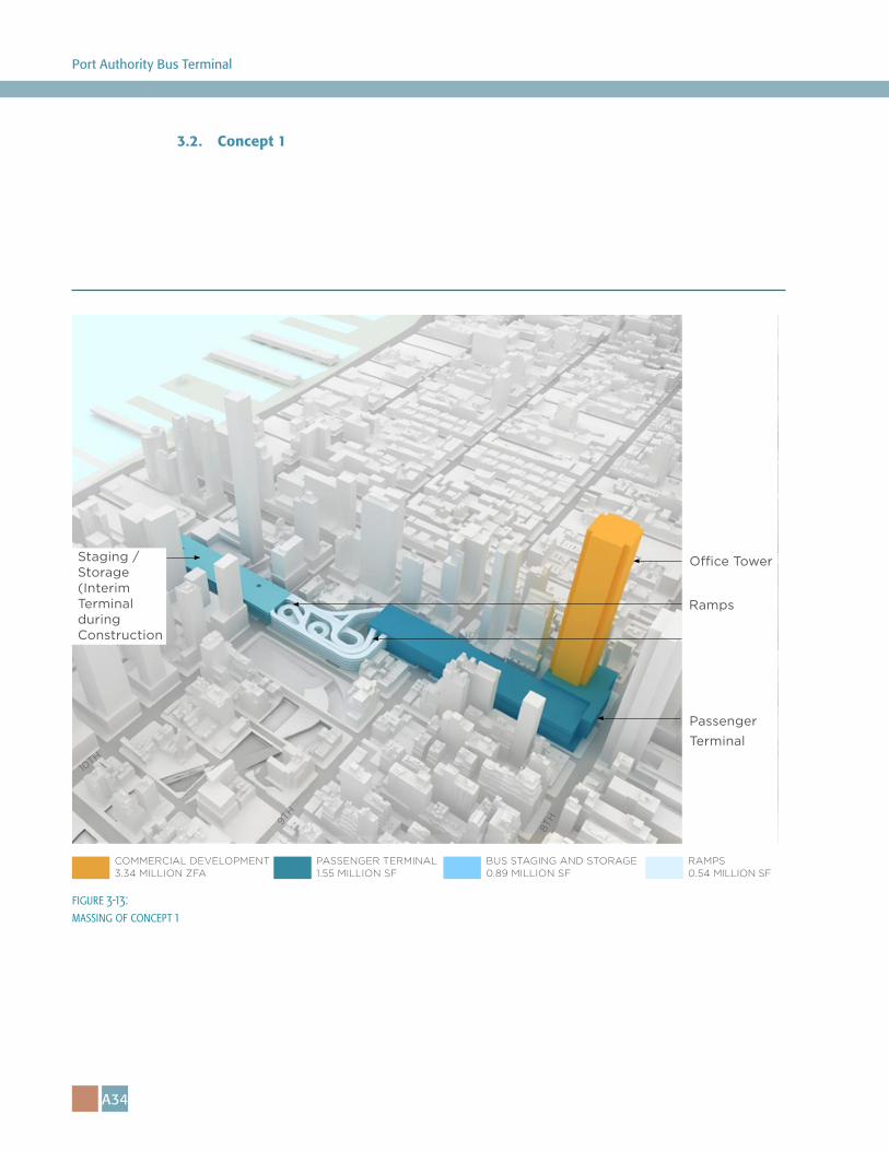
3.2. Concept 1
COMMERCIAL DEVELOPMENT 3.34 MILLION ZFA
8TH9T
H
10TH
PASSENGER TERMINAL 1.55 MILLION SF
BUS STAGING AND STORAGE 0.89 MILLION SF
RAMPS 0.54 MILLION SF
O�ce Tower
Passenger Terminal
Staging /Storage(Interim Terminal during Construction
Ramps
figure 3-13: massing of concept 1
A35
Appendix A: The Design + Deliverability Brief
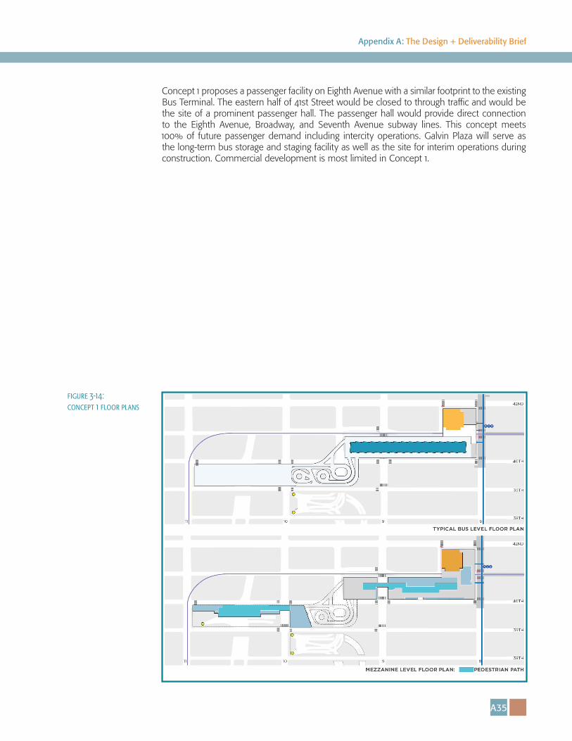
Concept 1 proposes a passenger facility on Eighth Avenue with a similar footprint to the existing Bus Terminal. The eastern half of 41st Street would be closed to through traffic and would be the site of a prominent passenger hall. The passenger hall would provide direct connection to the Eighth Avenue, Broadway, and Seventh Avenue subway lines. This concept meets 100% of future passenger demand including intercity operations. Galvin Plaza will serve as the long-term bus storage and staging facility as well as the site for interim operations during construction. Commercial development is most limited in Concept 1.
figure 3-14: concept 1 floor plans
A36
Port Authority Bus Terminal
3.3. Concept 2
8TH9T
H
10TH
O�ce Tower
Passenger Terminal
Staging /Storage(Interim Terminal during Construction
COMMERCIAL DEVELOPMENT 5.04 MILLION ZFA
PASSENGER TERMINAL 1.42 MILLION SF
BUS STAGING AND STORAGE 0.89 MILLION SF
RAMPS 0.54 MILLION SF
Ramps
figure 3-15: massing of concept 2
A37
Appendix A: The Design + Deliverability Brief
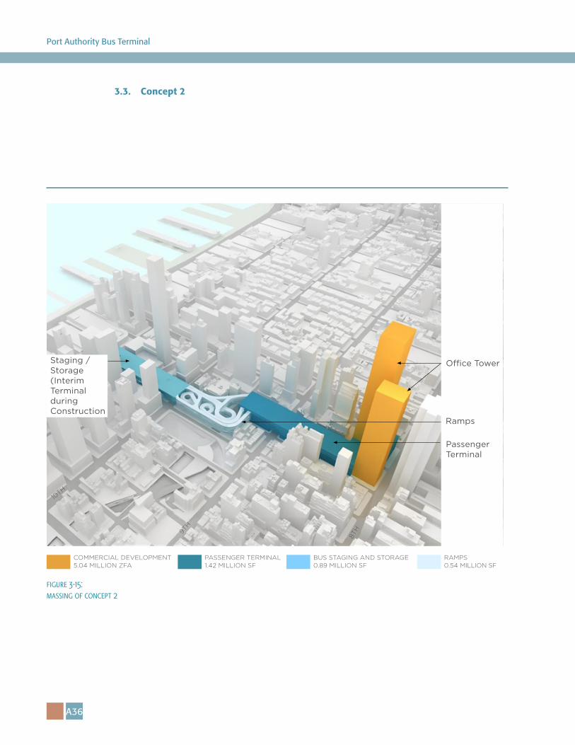
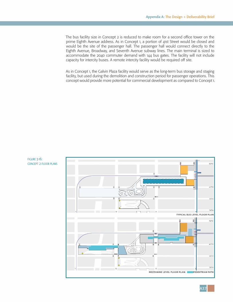
The bus facility size in Concept 2 is reduced to make room for a second office tower on the prime Eighth Avenue address. As in Concept 1, a portion of 41st Street would be closed and would be the site of the passenger hall. The passenger hall would connect directly to the Eighth Avenue, Broadway, and Seventh Avenue subway lines. The main terminal is sized to accommodate the 2040 commuter demand with 144 bus gates. The facility will not include capacity for intercity buses. A remote intercity facility would be required off site.
As in Concept 1, the Galvin Plaza facility would serve as the long-term bus storage and staging facility, but used during the demolition and construction period for passenger operations. This concept would provide more potential for commercial development as compared to Concept 1.
figure 3-16: concept 2 floor plans
A38
Port Authority Bus Terminal
3.4. Concept 3
8TH9T
H
10TH
Staging /Storage
COMMERCIAL DEVELOPMENT 6.2 MILLION ZFA
PASSENGER TERMINAL 1.67 MILLION SF
BUS STAGING AND STORAGE .62 MILLION SF
RAMPS .45 MILLION SF
Passenger Terminal
O�ce Tower
Administrative O�ces
Ramps
Passenger Hall
figure 3-17: massing of concept 3
A39
Appendix A: The Design + Deliverability Brief
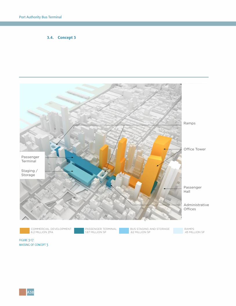
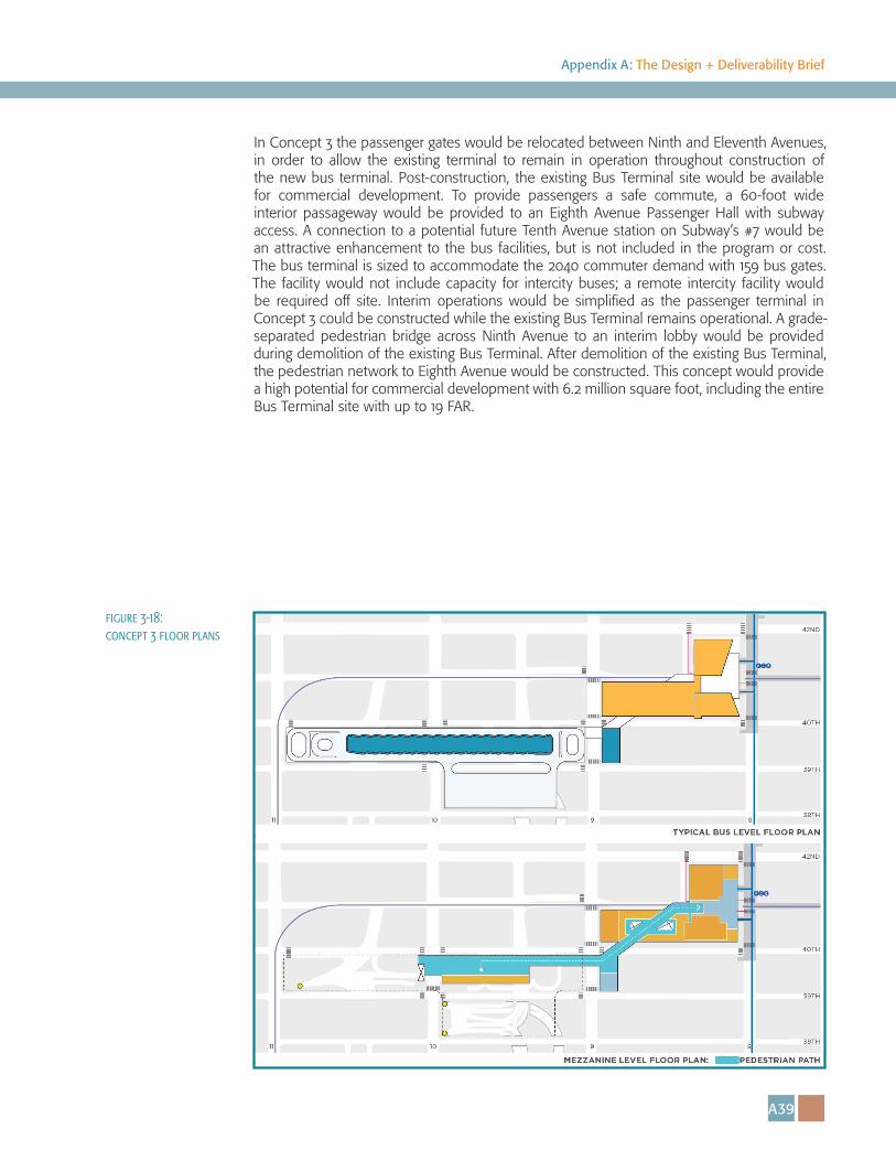
In Concept 3 the passenger gates would be relocated between Ninth and Eleventh Avenues, in order to allow the existing terminal to remain in operation throughout construction of the new bus terminal. Post-construction, the existing Bus Terminal site would be available for commercial development. To provide passengers a safe commute, a 60-foot wide interior passageway would be provided to an Eighth Avenue Passenger Hall with subway access. A connection to a potential future Tenth Avenue station on Subway’s #7 would be an attractive enhancement to the bus facilities, but is not included in the program or cost. The bus terminal is sized to accommodate the 2040 commuter demand with 159 bus gates. The facility would not include capacity for intercity buses; a remote intercity facility would be required off site. Interim operations would be simplified as the passenger terminal in Concept 3 could be constructed while the existing Bus Terminal remains operational. A grade-separated pedestrian bridge across Ninth Avenue to an interim lobby would be provided during demolition of the existing Bus Terminal. After demolition of the existing Bus Terminal, the pedestrian network to Eighth Avenue would be constructed. This concept would provide a high potential for commercial development with 6.2 million square foot, including the entire Bus Terminal site with up to 19 FAR.
figure 3-18: concept 3 floor plans
A40
Port Authority Bus Terminal
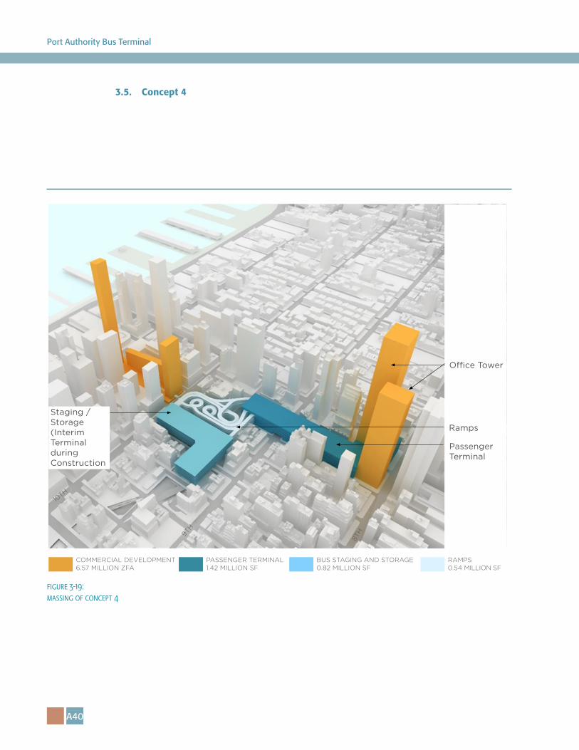
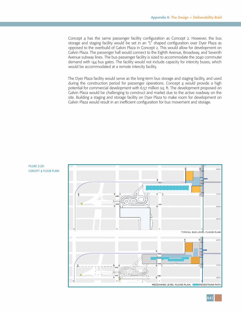
3.5. Concept 4
8TH9T
H
10TH
O�ce Tower
Passenger Terminal
Staging /Storage(Interim Terminal during Construction
Ramps
COMMERCIAL DEVELOPMENT 6.57 MILLION ZFA
PASSENGER TERMINAL 1.42 MILLION SF
BUS STAGING AND STORAGE 0.82 MILLION SF
RAMPS 0.54 MILLION SF
figure 3-19: massing of concept 4
A41
Appendix A: The Design + Deliverability Brief
Concept 4 has the same passenger facility configuration as Concept 2. However, the bus storage and staging facility would be set in an “L” shaped configuration over Dyer Plaza as opposed to the overbuild of Galvin Plaza in Concept 2. This would allow for development on Galvin Plaza. The passenger hall would connect to the Eighth Avenue, Broadway, and Seventh Avenue subway lines. The bus passenger facility is sized to accommodate the 2040 commuter demand with 144 bus gates. The facility would not include capacity for intercity buses, which would be accommodated at a remote intercity facility.
The Dyer Plaza facility would serve as the long-term bus storage and staging facility, and used during the construction period for passenger operations. Concept 4 would provide a high potential for commercial development with 6.57 million sq. ft. The development proposed on Galvin Plaza would be challenging to construct and market due to the active roadway on the site. Building a staging and storage facility on Dyer Plaza to make room for development on Galvin Plaza would result in an inefficient configuration for bus movement and storage.
figure 3-20: concept 4 floor plans
A42
Port Authority Bus Terminal
3.6 Concept 5
8TH9T
H
10TH
O�ce Tower
Administrative O�ces
Passenger Terminal & Staging/ Storage
COMMERCIAL DEVELOPMENT 7.04 MILLION ZFA
PASSENGER TERMINAL & STAGING/STORAGE1.67 MILLION SF
RAMPS .45 MILLION SF
50%OF THE
DEMAND
Ramps
Passenger Hall
figure 3-21: massing of concept 5
A43
Appendix A: The Design + Deliverability Brief
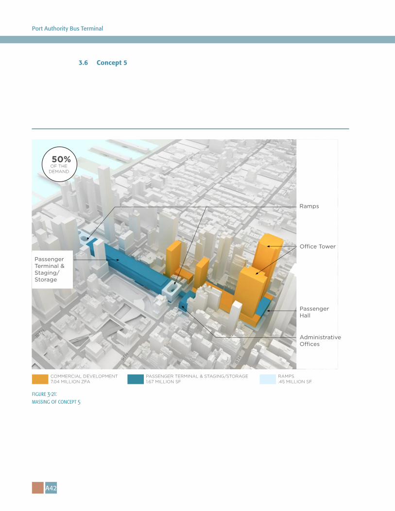
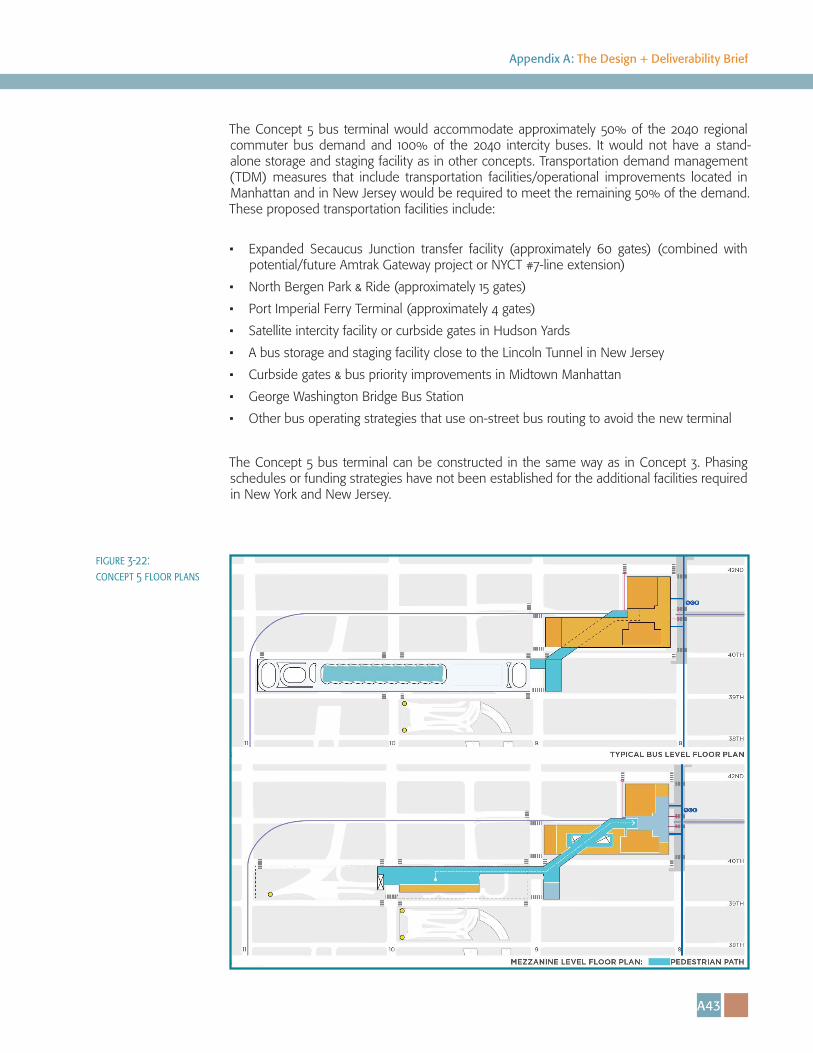
The Concept 5 bus terminal would accommodate approximately 50% of the 2040 regional commuter bus demand and 100% of the 2040 intercity buses. It would not have a stand-alone storage and staging facility as in other concepts. Transportation demand management (TDM) measures that include transportation facilities/operational improvements located in Manhattan and in New Jersey would be required to meet the remaining 50% of the demand. These proposed transportation facilities include:
• Expanded Secaucus Junction transfer facility (approximately 60 gates) (combined with potential/future Amtrak Gateway project or NYCT #7-line extension)
• North Bergen Park & Ride (approximately 15 gates)
• Port Imperial Ferry Terminal (approximately 4 gates)
• Satellite intercity facility or curbside gates in Hudson Yards
• A bus storage and staging facility close to the Lincoln Tunnel in New Jersey
• Curbside gates & bus priority improvements in Midtown Manhattan
• George Washington Bridge Bus Station
• Other bus operating strategies that use on-street bus routing to avoid the new terminal
The Concept 5 bus terminal can be constructed in the same way as in Concept 3. Phasing schedules or funding strategies have not been established for the additional facilities required in New York and New Jersey.
figure 3-22: concept 5 floor plans
A44
Port Authority Bus Terminal
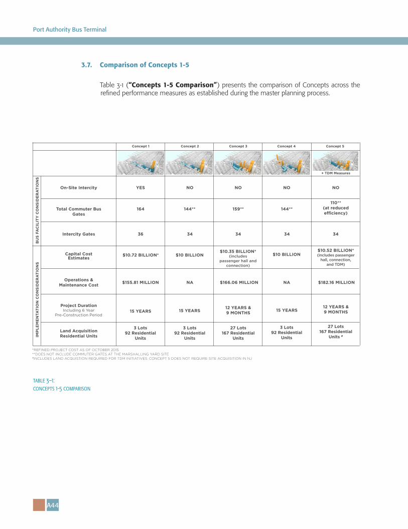
3.7. Comparison of Concepts 1-5
Table 3-1 (“Concepts 1-5 Comparison”) presents the comparison of Concepts across the refined performance measures as established during the master planning process.
*REFINED PROJECT COST AS OF OCTOBER 2015**DOES NOT INCLUDE COMMUTER GATES AT THE MARSHALLING YARD SITE#INCLUDES LAND ACQUISTION REQUIRED FOR TDM INITIATIVES. CONCEPT 5 DOES NOT REQUIRE SITE ACQUISITION IN NJ
Concept 1 Concept 2 Concept 3 Concept 4 Concept 5
Intercity Gates
On-Site Intercity YES NO NO NO NO
+ TDM Measures
Total Commuter Bus Gates
164 144** 159** 144**110**
(at reduced e�ciency)
BU
S FA
CIL
ITY
CO
NSI
DE
RA
TIO
NS
Operations & Maintenance Cost $155.81 MILLION NA $166.06 MILLION NA $182.16 MILLION
36 343434 34
Capital Cost Estimates
Project Duration Including 6 Year
Pre-Construction Period15 YEARS 15 YEARS
12 YEARS &9 MONTHS
12 YEARS &9 MONTHS15 YEARS
$10.72 BILLION* $10 BILLION$10.35 BILLION*
(includes passenger hall and
connection)
$10 BILLION
Land AcquisitionResidential Units
3 Lots 92 Residential
Units
$10.52 BILLION*(includes passenger
hall, connection, and TDM)
27 Lots 167 Residential
Units
27 Lots 167 Residential
Units #
3 Lots 92 Residential
Units
3 Lots 92 Residential
UnitsIMP
LEM
EN
TATI
ON
CO
NSI
DE
RA
TIO
NS
table 3–1: concepts 1-5 comparison

A45
Appendix A: The Design + Deliverability Brief

4 World Trade Center150 Greenwich StreetNew York, NY 10007