Embed Size (px)
Citation preview

Palmer Reconnaissance Report Connecticut River Valley Reconnaissance Survey Massachusetts Heritage Landscape Inventory Program
JUNE, 2009
Massachusetts Department of Conservation and Recreation Pioneer Valley Planning Commission Franklin Regional Council of Governments
PROJECT TEAM Massachusetts Department of Conservation and Recreation Richard K. Sullivan, Jr., Commissioner Joe Orfant, Director, Bureau of Planning & Resource Protection Patrice Kish, Director, Office of Cultural Resources Wendy Pearl, Director, Historic Landscape Preservation Initiative Jessica Rowcroft, Preservation Planner, Heritage Landscape Inventory Program Regional Partners & Project Consultants Pioneer Valley Planning Commission Bonnie Parsons, Principal Planner, Manager of Historic Preservation Programs Anne Capra, Principal Planner, Land Use Jim Scace, Senior Planner, GIS Specialist Franklin Regional Council of Governments Margaret Sloan, Director of Planning & Development Melissa Adams, Land Use Program Manager Kimberly Noake MacPhee, Natural Resources Planner Patricia Smith, Land Use Planner Ryan Clary, GIS Specialist Local Project Coordinator Linda Leduc, Palmer Town Planner Local Heritage Landscape Participants
Michele Barker, Preservation Massachusetts Don Duffy, Palmer Conservation Commission Roger Duguay, Jr., Palmer Town Council Douglas Faner, Journal Register Pat Ford Janice Fountain Donald Frydryk Phillip Hebert, Palmer Town Council David Johnson, Palmer Conservation Commission Blake Lamothe Michael Marciniec, Palmer Planning Board Dot Nadolski Karen Nadolski Lorraine Novak, Palmer Historical Commission Steve Nowak, Palmer Historical Commission Beverly Pease Nelson Pease
Eric Raymond Bob Ring, Palmer Historical Commission & Conservation Commission Mike Rondeau John Sasur Ed Schlesinger Regine Schlesinger David Swirk, PRA

INTRODUCTION Heritage landscapes are special places created by human interaction with the natural environment that help define the character of a community and reflect its past. They are dynamic and evolving, reflect the history of a community and provide a sense of place. They show the natural ecology that influenced land use patterns and often have scenic qualities. This wealth of landscapes is central to each community’s character, yet heritage landscapes are vulnerable and ever changing. For this reason it is important to take the first step toward their preservation by identifying those landscapes that are particularly valued by the community – a favorite local farm, a distinctive neighborhood or mill village, a unique natural feature or an important river corridor. To this end, the Massachusetts Department of Conservation and Recreation (DCR) and its regional partners, the Franklin Regional Council of Governments (FRCOG) and the Pioneer Valley Planning Commission (PVPC), have collaborated to bring the Heritage Landscape Inventory program to twelve communities in the Connecticut River valley region of Massachusetts. The goals of the program are to help communities identify a wide range of landscape resources, particularly those that are significant and unprotected, and to provide communities with strategies for preserving heritage landscapes.
Connecticut River Valley Heritage Landscape Inventory Project Area

The communities within the Connecticut River valley region of Massachusetts are diverse in their settlement patterns and economic histories. What they hold in common is a foundation built on agriculture that was carried out in communities traversed by a series of major waterways and tributaries, from the Connecticut River to the Deerfield, Sawmill, Green, Millers, Quaboag, Swift, Mill and Ware Rivers. This region contains significant cultural and historic resources and uncommon natural beauty. For some of the communities, industry developed alongside agriculture, so that today the heritage landscapes reflect both agrarian and industrial pasts while providing recreational and educational opportunities. From scenic town commons and natural areas, to civic buildings and burial grounds, the heritage landscapes within the region collectively tell the story of their varied and often complex history. Methodology The methodology for the Heritage Landscape Inventory program was developed in a pilot project conducted in southeast Massachusetts. It is outlined in the DCR publication Reading the Land, which has provided guidance for the program since its inception. In summary, each community organized a heritage landscape identification meeting during which residents and town officials identified and prioritized the natural and cultural landscapes within town that embody the community’s unique character. This meeting was followed by a fieldwork session led by the project team, including the local project coordinator and staff of FRCOG or PVPC, accompanied by interested community members. During the fieldwork session the Priority Heritage Landscapes were assessed and opportunities for preservation were explored and discussed. The final product for each community is an individualized Heritage Landscape Reconnaissance Report. This report outlines the community’s landscape history, describes the priority heritage landscapes along with associated opportunities, issues, and recommendations, and concludes with implementation strategies. PART I: HERITAGE LANDSCAPE INVENTORY
3

LOCAL HISTORY The town of Palmer has a varied landscape combining both plain and hilly uplands, and it is crossed by four rivers: the Chicopee, the Quaboag, the Ware and Swift Rivers. It is bordered on the north by Ware and Belchertown, on the west by Ludlow and Wilbraham, on the south by Monson, and on the east by Brimfield and Warren. Native Americans occupied the area that was to become Palmer concentrating seasonally upstream of the confluence of the Chicopee, Ware and Quaboag Rivers. Unlike the towns of Springfield, Hadley, and Hatfield, Palmer was not settled as a Plantation established by Proprietors - or investors - who set up a linear street settlement and sold off its homelots and agricultural land to settlers. Rather, an area that included Palmer, parts of Ware and Warren - and called “The Elbow Tract” - was settled by small groups or families who received grants of land that they divided up among themselves and sold to others. John King, about 1716, was the first to arrive in the district and took over about 325 acres of land, to which he continued to add. Heightened settlement began in 1732 when about eighty families came to The Elbow Tract. They came from Springfield, from the Connecticut River valley, and from eastern Massachusetts and were distinguished as being Scotch-Irish, a group of people with a reputation as being rather fiercely independent. The first area of Scotch-Irish settlement was in northeast Palmer in what is commonly known as the “Shaw District”. The Scotch-Irish were Presbyterian in religion rather than Congregationalist. Between 1716 and 1775 Palmer was an agricultural community with a few mills sawing lumber and grinding grain, a tannery, and turpentine factory contributing to the town’s growth. Palmer Center was located in the area of Old Warren Road, Flynt Street, and Breckenridge Street. It was here, near the 1730 Presbyterian meetinghouse, that Old Center Cemetery was established in 1735 and where many early residents are buried.
1761 William Brown marker in Old Center Cemetery. In 1752 Palmer became a township and by 1776, it had 727 residents. A powder pound, or powder house, was constructed in Old Center in 1799, presumably to store powder for the militia who trained nearby on the Ware Road.
4
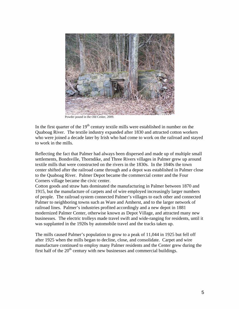
Powder pound in the Old Center, 2009. In the first quarter of the 19th century textile mills were established in number on the Quaboag River. The textile industry expanded after 1830 and attracted cotton workers who were joined a decade later by Irish who had come to work on the railroad and stayed to work in the mills. Reflecting the fact that Palmer had always been dispersed and made up of multiple small settlements, Bondsville, Thorndike, and Three Rivers villages in Palmer grew up around textile mills that were constructed on the rivers in the 1830s. In the 1840s the town center shifted after the railroad came through and a depot was established in Palmer close to the Quaboag River. Palmer Depot became the commercial center and the Four Corners village became the civic center. Cotton goods and straw hats dominated the manufacturing in Palmer between 1870 and 1915, but the manufacture of carpets and of wire employed increasingly larger numbers of people. The railroad system connected Palmer’s villages to each other and connected Palmer to neighboring towns such as Ware and Amherst, and to the larger network of railroad lines. Palmer’s industries profited accordingly and a new depot in 1881 modernized Palmer Center, otherwise known as Depot Village, and attracted many new businesses. The electric trolleys made travel swift and wide-ranging for residents, until it was supplanted in the 1920s by automobile travel and the tracks taken up. The mills caused Palmer’s population to grow to a peak of 11,044 in 1925 but fell off after 1925 when the mills began to decline, close, and consolidate. Carpet and wire manufacture continued to employ many Palmer residents and the Center grew during the first half of the 20th century with new businesses and commercial buildings.
5

Depot Village in the 1960s, Main Street. Today about 66% of the town’s residents commute out of Palmer to work. They work largely (55%) in the service sector while only 15% still work in manufacturing. With an exit from the Massachusetts Turnpike and an active railroad passing through the Center, Palmer is attractive for commuting residents and business, most recently to casino proposals and development of an automotive racetrack. Palmer, with its four villages Thorndike, Bondsville, Three Rivers and Depot Village, is 20,946 acres in size. Of those acres, 14,261 are undeveloped, and 3,110 are in residential use. Agriculture continues to be practiced on 1,296 acres. This means that Palmer has concentrated areas of dense population, but that the town has large expanses of woodland, and open space, and river landscape within its borders. Much of this undeveloped land is in the northern uplands, a rugged landscape of hills.
View of Depot Center and wooded uplands, ca. 1920.
6

Brook
Jabish Brook
Beav
er B
rook
Penn
y Bro
ok
Jabish Bro
o k
S ch ool Stre et Brook
Kings B ro ok
Blodgett Mill Brook
Graves BrookUpper and LowerReservoirs
Cal
kins
Br o
ok
Ware Riv er
Penny Brook
Calk ins Broo k
Bot tl e B rook
Allen Pond
Maxwell B roo k
Mou
ntai
n Br
ook
Twelvemile Brook
Foske tt
Chicopee Brook
War
e R
iver
PottaquatticPond
LillyPond Forest
Lake
Swift R
i ve r
CrystalLake
Ware Ri ver
CHIC
OPEE RIVER
ThompsonLake
KnoxPond
Qua
b oag
Ri v
er
Quaboag River
Quaboag River
Pulpit RockPond
NativeAmerican
Weir
ThorndikeMills
Ice HousePond Area
Old CenterCemetery
ShawDistrict
Rogers Farm
H.H. Richardson Railroad Station & F. L. Olmsted Park
King Farm
BACON STREET
BACON
ST REET
WE
ST W
AR
E R
OA
D
FOS
TER
ST R
EE
T
RIVER STR EET
MAI
N STR
EET
GR IFFIN STREET
EM
ER
Y S
TRE
ET
RON DEAU STREETM
AI N
ST R
EE
T
LAUR
EN
DRIVE
OLN
EY
RO
AD
BENNETT STREET
STATE
STREET
W ILBRAHAM STREET
SUM
MER
STR
EET
SUM
ME
R S
T RE E
T
FOREST
L AKE
ROAD
FLY
NT
STR
EE
T
TH
OR
ND
IKE
ST
RE
ET
THOMPSON
STR E
ET
BO
ST
ON
RO
AD
BRIDGE
STREE T
PALMER STREET
RU
GGL ES
STREE
T
CHUD Y STR EET
WRIGHT STREET
SU MMER STREET
HIGH STREE T
SYKE
S S
TRE
ET
PAUL ST
SOU TH
MAIN STREET
STIM
SO
N S
TRE
ET
M AIN
STREET
MAIN STREET
RIV
ER
STR
EE
T
SO
UTH
MAIN
ST
RE
ET
MOU
NT DUMPLIN
ST REET
PINNEY STREET
WA
RE
RO
AD
PLEASANT STREET
LONGVIEW
STREET
MAIN STREETWAR REN STREET
PINE STREET
NO
RT
H S
TRE
ET
MA
SON
STR
EE
T
THREE RIVERS R OAD
PARK STREET
CHURCH STREET
BU RLINGAME R OAD
BE
LCH
ER
TOW
N ST
RE
ET
SHEARER STREET
FORD STREET
LAW RENCE STR EET
PETE
RS
ON
RO
AD
PINE STREET
OAK STREET
BEACON DR IVE
BA
PTI
ST
HIL
L R O
AD
WHALLEN ST
SPRIN GFIELD STREET
FOREST STREET
HILL S
IDE
DRIV
E
SEC OND STREET
PINE STREET
SAIN
T JO
HN
S TR
E ET
F UL LE
R RO
AD
BOUR NE STR EET
MASSACHU SETTS TURNPIKE
HIG
H S
TRE
ET
WARREN STREET
CA LK
INS
RO
A D
OVERLOOK
DR
IVE
NIPMU CK STREET
F RENCH
DR
IVE
WATER
STREET
PLEASANT
STREET
O LD R OU TE 20
ALLEN STREET
SM
ITH ST
MASSACHUSETTS TURNPIKE
WARREN ROAD
FULLER STREET
THORN
DIKE
STREE
T
P AL M
ER
STR
E ET
GATES
STREET
GATE
S STREET
COUNTRY STREE T
BE
EC
H ST
RE
ET
BLANCHARD ST
ROBINSON
STREET
BR
EC
KE
NR
IDG
E S
TRE
ET
WA
RE
ROA
D
LAUREL
ROAD
OLD FARM R
OA
D
SMITH STR EET
HOMESTEAD
STR
EET
CABOT
STR EET
SOUT
H
STREET
BARKER STRE
ET
MEMORY LANE
SO
UTH
ST
RE
ET
CHAMBER
RO
AD
JIM A
S H R
OAD
BRIMFIELD
WARREN
BR
IMFI E
L D
MO
NS
ON
WA
RE
BELC
HE
RTO
WN
WILB
RA
HA
MM
ON
SO
N
0 0.5 10.25
Miles
Town ofPalmer, MATown of Palmer
Heritage Landscape Inventory Project,Connecticut River Valley
Historic Landscapes Map Sources:
Pioneer Valley Planning Commission, 2009.Massachusetts Executive Office of Transportation, Massachusetts Highway Department,andthe Massachusetts Executive Office of Energy and the Environment, MassGIS.
Funding:
The Massachusetts Executive Office of Energy and the EnvironmentDepartment of Conservation Resources
Permanently Protected Open Space
7

PRIORITY HERITAGE LANDSCAPES Palmer held its Heritage Landscape Identification meeting on January 22, 2009 with twenty-four people attending. The group developed a master list during the meeting of Palmer’s heritage landscapes with a total of fifty-one. From the master list seven priority landscapes were then identified. They are as follows: the fishing weir, Thorndike Mills, Ice House Pond, Old Center Cemetery, the Shaw District, the Jesse King and Robert Rogers Farms, and H. H. Richardson Railroad Depot and Olmsted Park. Native American Fishing Weir
Palmer fishing weir on Ware River. The fishing weir is upstream of the confluence of the Quaboag, Chicopee, and Ware Rivers. It is a fieldstone structure set on the river bed and visible only when the water is at a lower level than it was at the time of this study. The weir projects from the shore into the river, follows an arc, and acts as a partial dam in the river. It appears to be about one foot in height and to be made up of medium-sized fieldstones. The weir acted as a barrier to fish in the river and it is believed that the Native Americans stood on and around it, and used nets to scoop up the fish as they arrived. From the few remaining examples of fish weirs across the country, it is clear that some weirs were made with stakes, some with stones, and all seem to have used funnels to direct the fish as they traveled downstream toward a spout at which they could be caught. J. H. Temple in his History of the Town of Palmer of 1889 described the use of a weir. The place in the river where a weir was built was known as a “Menamesick” to the Native Americans and was mostly set at the foot of a waterfall. Salmon were caught in the weirs going back downstream after having spawned. As Temple recorded it,
8

“These weirs were simply rude stone walls built from opposite sides of the river, pointing downstream, till they nearly met each other. At this narrow opening a large cage was placed, formed of twigs fastening to hoops by strings of tough bark. When trapped in this cage, the frightened fish were easily captured.”
Arc of weir visible in low water conditions. The Palmer fish weir has not been dated, but it is thought to have been constructed during the 16th or early 17th century when a Native American group, the Nipmucks, came to the rivers during the spring and summer for fishing. The weir has long been identified in Palmer history and appears on the town flag and seal as part of its heritage.
Municipally-owned land in area of potential weir trail View of Ware River from municipal land. Opportunities:
• This is a rare Native American artifact in Palmer and has historical significance to the region as a whole.
9
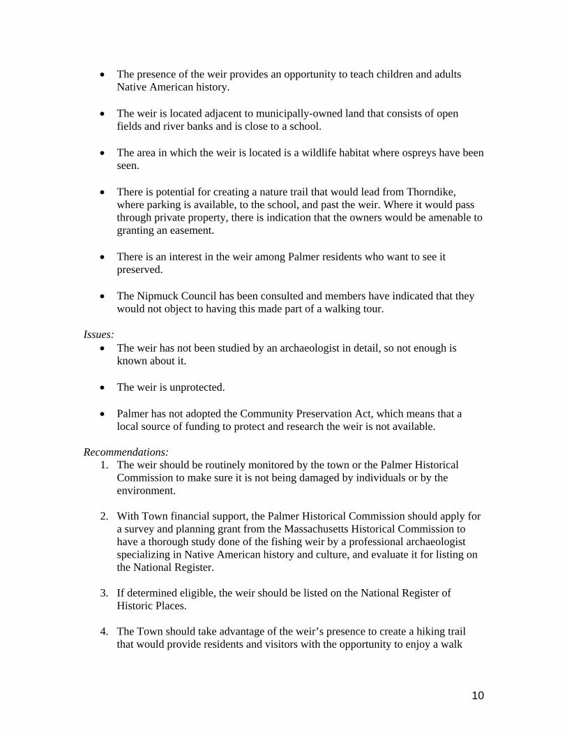
• The presence of the weir provides an opportunity to teach children and adults Native American history.
• The weir is located adjacent to municipally-owned land that consists of open
fields and river banks and is close to a school.
• The area in which the weir is located is a wildlife habitat where ospreys have been seen.
• There is potential for creating a nature trail that would lead from Thorndike,
where parking is available, to the school, and past the weir. Where it would pass through private property, there is indication that the owners would be amenable to granting an easement.
• There is an interest in the weir among Palmer residents who want to see it
preserved.
• The Nipmuck Council has been consulted and members have indicated that they would not object to having this made part of a walking tour.
Issues:
• The weir has not been studied by an archaeologist in detail, so not enough is known about it.
• The weir is unprotected.
• Palmer has not adopted the Community Preservation Act, which means that a
local source of funding to protect and research the weir is not available. Recommendations:
1. The weir should be routinely monitored by the town or the Palmer Historical Commission to make sure it is not being damaged by individuals or by the environment.
2. With Town financial support, the Palmer Historical Commission should apply for
a survey and planning grant from the Massachusetts Historical Commission to have a thorough study done of the fishing weir by a professional archaeologist specializing in Native American history and culture, and evaluate it for listing on the National Register.
3. If determined eligible, the weir should be listed on the National Register of
Historic Places.
4. The Town should take advantage of the weir’s presence to create a hiking trail that would provide residents and visitors with the opportunity to enjoy a walk
10

along the Ware River and to see the weir. An interpretive sign at the weir could be developed so that its former use is demonstrated clearly.
5. The Town should work with local land trusts and the owners of the area on the
north side of the river, which is unprotected. The land could be acquired or a conservation restriction purchased so that there is no threat to the integrity of the weir from that direction.
6. The Town could consider adopting an Archaeological Resource Protection bylaw
for the land on the north side of the river. This would require that any development of that land be reviewed for its impact on the weir and re-directed to a less-damaging location.
11

PAUL ST
BRIDGE STREET
RU
GG
LES STR
EET
CHUDY STREET
SYKES S
TRE
ET
MAIN STREET
FULLER
ROAD
NO
RTH
STR
EET
BELC
HE
RTO
WN
STR
EE
T
OAK STREET
BOURNE STREET
CH
ARLES
STREET
PLEASANT
STR
EE
T
FULLER STREET
PALM
ER S
TRE
ET
0 1,000
Feet
Town ofPalmer, MA
Map Sources:
Pioneer Valley Planning Commission, 2009.Massachusetts Executive Office of Transportation, Massachusetts Highway Department,andthe Massachusetts Executive Office of Energy and the Environment, MassGIS.
Funding:
The Massachusetts Executive Office of Energy and the EnvironmentDepartment of Conservation Resources
Native American Weir
Permanently Protected Open Space
Historic Landscape
Other Historic Landscapes
Town of Palmer, Massachusetts,Heritage Landscape Inventory Project,
Connecticut River Valley
PVPC_227_1
12

Thorndike Mills
Postcard painting of No. 2 Mill in Thorndike with path from worker’s housing in right foreground.
The village of Thorndike in Palmer was built around cotton textile mills on the Ware River. The first Thorndike Company mill was constructed in 1837 on the lower privilege of the Ware River and a second mill, in 1845-46, on the upper privilege about 750 yards upstream. Both mill buildings were constructed in granite, five stories high and with seven-story high stair towers. Workers’s housing was constructed in walking distance of the mill. The mills produced cotton goods from short staple cotton until 1926 and the upper mill (No.2) was bought by S.C.S. Box Company in 1927.
Thorndike Mill No. 2, 2009. Mill No.2, after a period of vacancy, had its water power system rehabilitated so that the buildings could generate power. Today the one-story brick portion of the mill is occupied rent-free by artists because the owner subsidizes the artists with money from the sale of electricity. The private owner is planning to rehabilitate the rest of the mill complex on the five acre site and he owns approximately twenty acres in the area all the way from the mills to the power canal in the village center. Across the street from the mills are “the 88 Steps”, another heritage landscape site that led from workers’s housing on the hill above the mills down to the mills.
13

Opportunities:
• The Town of Palmer was selected by the Valley Development Council to take part in a competition on ideas for reuse of selected sites, and the Thorndike Mills will be a subject of the design/reuse competition.
• The granite section of the mills - as well as the more recent brick sections - are in
excellent condition structurally; and architecturally, the entire complex is very fine.
• The mills are located on the Ware River, which is a landscape of considerable
beauty.
• The owner of the mills intends to rehabilitate the mills for reuse.
• Hydroelectric power generation at the mills produces income and is a source of clean energy production.
Issues:
• Much of the space of the mill complex is unoccupied.
• The sale of power does not net sufficient income to rehabilitate the buildings.
• An income-producing use or mix-of-uses for the buildings have not yet been identified.
• The buildings are unprotected.
Recommendations:
1. The mill complex should be listed on the National Register of Historic Places, which would enhance its desirability as a development using federal, state and New Market Tax Credits. Ideally, the village of Thorndike should be listed as an historic district and the Thorndike mills and “the 88 Steps” as contributing resources within the district.
2. After the competition has identified some reuse options for the mills, the Town
should consider adopting an Adaptive Reuse Zone or Overlay District with design guidelines and site plan review. This will give the Planning Board flexibility for reuse proposals and for parking and dimensional requirements.
3. The Town of Palmer should consider adopting the Community Preservation Act,
which could assist the owner to do rehabilitation work by funding a preservation plan or an historic structure report on his building complex. It could also fund restoration of “the 88 Steps”.
14

HIGH STREET
SYKES S
TRE
ET
MAIN STREET
CHURCH STREET
ELIZABETH STREET
RIV
ER
STR
EE
T
PALM
ER
STRE
ET
PINE STREET
PLEASANT STREET
THO
RND
IKE STREETFULLER
STREETH
ILL STREET
SU
MM
ER
STR
EE
T
0 1,000
Feet
Town ofPalmer, MA
Map Sources:
Pioneer Valley Planning Commission, 2009.Massachusetts Executive Office of Transportation, Massachusetts Highway Department,andthe Massachusetts Executive Office of Energy and the Environment, MassGIS.
Funding:
The Massachusetts Executive Office of Energy and the EnvironmentDepartment of Conservation Resources
Thorndike Mills
Permanently Protected Open Space
Historic Landscape
Other Historic Landscapes
Town of Palmer, Massachusetts,Heritage Landscape Inventory Project,
Connecticut River Valley
PVPC_227_2
15
Ice House Pond
Ice House Pond viewed towards north east, 2009.
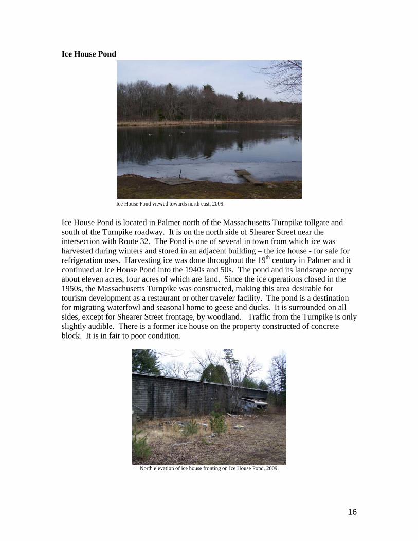
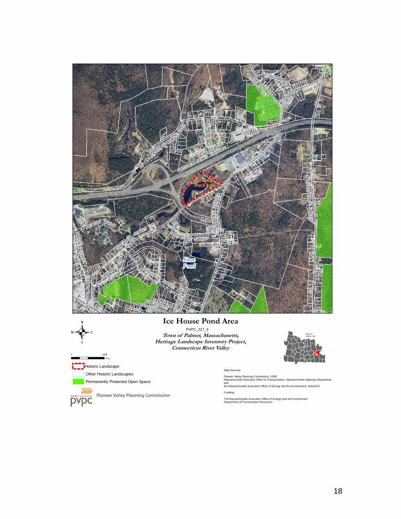
Ice House Pond is located in Palmer north of the Massachusetts Turnpike tollgate and south of the Turnpike roadway. It is on the north side of Shearer Street near the intersection with Route 32. The Pond is one of several in town from which ice was harvested during winters and stored in an adjacent building – the ice house - for sale for refrigeration uses. Harvesting ice was done throughout the 19th century in Palmer and it continued at Ice House Pond into the 1940s and 50s. The pond and its landscape occupy about eleven acres, four acres of which are land. Since the ice operations closed in the 1950s, the Massachusetts Turnpike was constructed, making this area desirable for tourism development as a restaurant or other traveler facility. The pond is a destination for migrating waterfowl and seasonal home to geese and ducks. It is surrounded on all sides, except for Shearer Street frontage, by woodland. Traffic from the Turnpike is only slightly audible. There is a former ice house on the property constructed of concrete block. It is in fair to poor condition.
North elevation of ice house fronting on Ice House Pond, 2009.
16

Opportunities: • Ice House Pond is a lovely inland body of water. It supports wildlife and is
buffered from its surroundings by woodland.
• A small concrete remnant of a dock from the ice operation is still visible at the water’s edge.
• The Pond is protected under the Wetlands Protection Act and a local wetland
protection bylaw.
• The Pond is a relatively large body of water with interesting, varied views. Issues:
• The Pond is privately owned and in an industrial zone, so although the owners may wish to do well by the landscape, development in the future could mean a loss of visual access to the pond or further degradation of the landscape.
• The available land is very small for a commercial building.
• The landscape is littered and deteriorated, and refuse has been left in the pond
water.
• Several efforts to place buildings for commercial use on the landscape have failed and the permit of the most recent has expired.
• The Pond may be too far off the Turnpike exit to be successful as a commercial
destination. It is not a direct stop for travelers. Recommendations:
1. Palmer should work with local land trusts and the owner of the property to acquire the property or to acquire a conservation restriction on it.
2. An interpretive sign describing its history in ice harvesting would give visitors to
the area an educational opportunity.
3. The Town should consider adopting the Community Preservation Act, which could be used to make this pond a small nature preserve and passive recreational area, thereby preserving its heritage landscape status.
17
FAIR
VIE
W STR
EET
THO
RN
DIK
E ST
REE
T
VICARDAV
AVENUE
WARE ROAD
MOUNT DUMPLIN
STREE
T
PINE STREET
HIG
H STREET
LONGVIEW STREET
SHEARER STREET
LAWRENCE STREET
BEACON DRIVE
OAKLAND
STR
EET
RA
ND
AL L
STR
EE
T
MASSACHUSETTS TURNPIKE
DE
SIM
ON
E D
R
BR
EC
KE
NR
IDG
E S
TRE
ET
SQU
IRE
STR
EET
MEMORY LANE
0 1,000
Feet
Town ofPalmer, MA
Map Sources:
Pioneer Valley Planning Commission, 2009.Massachusetts Executive Office of Transportation, Massachusetts Highway Department,andthe Massachusetts Executive Office of Energy and the Environment, MassGIS.
Funding:
The Massachusetts Executive Office of Energy and the EnvironmentDepartment of Conservation Resources
Ice House Pond Area
Permanently Protected Open Space
Historic Landscape
Other Historic Landscapes
Town of Palmer, Massachusetts,Heritage Landscape Inventory Project,
Connecticut River Valley
PVPC_227_3
18
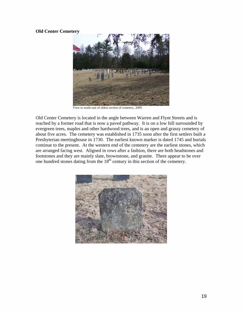
Old Center Cemetery
View to south east of oldest section of cemetery, 2009. Old Center Cemetery is located in the angle between Warren and Flynt Streets and is reached by a former road that is now a paved pathway. It is on a low hill surrounded by evergreen trees, maples and other hardwood trees, and is an open and grassy cemetery of about five acres. The cemetery was established in 1735 soon after the first settlers built a Presbyterian meetinghouse in 1730. The earliest known marker is dated 1745 and burials continue to the present. At the western end of the cemetery are the earliest stones, which are arranged facing west. Aligned in rows after a fashion, there are both headstones and footstones and they are mainly slate, brownstone, and granite. There appear to be over one hundred stones dating from the 18th century in this section of the cemetery.
19

Three 17th century markers of early Palmer settlers, 2009. The outstanding feature of the Old Center Cemetery is the art of carving that is represented among its oldest stones. There is a unique collection of markers that represent the work of some of the region’s finest carvers. The stones are by and large in fairly good condition, but there are losses that need to be addressed to stones from a range of dates, their condition dependent on the nature of the stone itself. At one time, the cemetery was used by the Monson State Hospital, which buried some of it patients here without markers of any sort. Opportunities:
• The Old Center Cemetery represents the core of the Town’s first village. There are two houses on Route 32 that were once part of the Center, along with the powder pound and foundations of the meetinghouse, and the Cemetery is their focal point.
20

• The cemetery offers data critical to genealogists and historians, and local historians have prepared a Massachusetts Historical Commission Burial Ground Inventory form for the cemetery.
• The cemetery has been well-maintained, stones are upright, and the vegetation
cared for.
• The cemetery is an aesthetically pleasing landscape.
• It is municipally-owned, so has a measure of protection. Issues:
• In a relatively out-of-the-way location, the cemetery could be vulnerable to vandalism or misuse.
• Despite its on-going maintenance many of the cemetery’s stones are in need of
repair and cleaning and protected against further deterioration from acid rain. Recommendations:
1. Old Palmer Cemetery should be placed on the National Register. This will make it eligible for state funding programs when they are available and the process pulls together the documentation on a cemetery that will be useful to historians and genealogists. It also becomes a permanent part of the Town’s historical record.
2. The town should consider preparing a preservation plan for the cemetery
landscape as a whole including evaluating stone conditions and documenting markers through writing and photography. For those of the stones that are rare and irreplaceable artifacts, the plan would provide strategies for conserving them. It would also provide recommendations for management of this historic landscape, assessing the vegetation, circulation, and access.
3. If Palmer were to adopt the Community Preservation Act there would be a
funding source to work on the cemetery, so that is recommended here as well as for the other heritage landscapes.
21

MOUNT DUMPLIN STREET
CHURCH STR
EET
VICARDAV
AVENUE
HIG
H STR
EET
WA
RE
RO
AD
THORNDIKE STREET
FLYNT STREETSMITH STREET
RIVER
STR
EE
T
ST IM
SO
N S
TRE
ET
WARREN STREET
FRENCH D
RIV
E
GATES
STREET
MASSACHUSETTS TURNPIKE
WAVERLY
ST
HILL
STREET
BR
EC
KE
NR
IDG
E S
TRE
ET
0 1,000
Feet
Town ofPalmer, MA
Map Sources:
Pioneer Valley Planning Commission, 2009.Massachusetts Executive Office of Transportation, Massachusetts Highway Department,andthe Massachusetts Executive Office of Energy and the Environment, MassGIS.
Funding:
The Massachusetts Executive Office of Energy and the EnvironmentDepartment of Conservation Resources
Old Center Cemetery
Permanently Protected Open Space
Historic Landscape
Other Historic Landscapes
Town of Palmer, Massachusetts,Heritage Landscape Inventory Project,
Connecticut River Valley
PVPC_227_4
22

The Shaw District
St. John Street in the Shaw District, 2009. The Shaw District is the site of an early settlement in Palmer dating from the 1730s. It is located in the northwest section of town on land that is a mix of private (Nenameseck Sports Club), state, and local conservation land ownership. This archaeological landscape contains foundations of houses, barns, two schools, and an ice house on a hillside near an inland lake.
18th century house and barn once located in District. None of the more than twenty buildings once located in this area is still standing in the District, but with the aid of 1901 photographs, their locations can be matched with foundations that do remain. Once open land, the area now is densely wooded and its roads have become walking trails into conservation land. The foundation of the former farm of Charles R. Shaw, across the street from the 1870 #2 schoolhouse foundations is thought to have served as a tavern on Bacon Road. The 1767 first schoolhouse foundation is located within the district as well.
23

Foundations of tightly-constructed, former ice house, 2009.
Barn foundations St. John’s Road, 2009.
Schoolhouse foundations with threshold stone, Bacon Road, 2009.
The foundations are located on the former Bacon, Rondeau, St. John and Tavern Roads and were the farms of, among others, Matthew Brown who was the first to arrive in 1733, Robert Brown, a Shaw district teacher, and the Erwin Shaw family. All were Scotch-Irish in descent and in 1767 when the first schoolhouse was built, this area was one of the more densely populated sections of town. It was an agricultural area and stone walls still border many of its early fields, but after the first quarter of the 19th century, residents began leaving the district to work in Palmer’s mills where more cash could be earned than in farming. The remaining farmers kept the district vital until about 1892 when
24

there were so few pupils that the #2 school was finally closed and burned shortly afterwards. Gradually fewer and fewer families remained in the Shaw district until the early 20th century when it was photographed as a nearly vacant settlement by Palmer residents with an interest in its history. Opportunities:
• Shaw District has archaeological significance for the Scotch-Irish settlement of Palmer in the 1730s and may have potential to elucidate much of Palmer’s farming history.
• There is photographic record of the appearance of the District’s buildings from
1901, which helps to document location and appearance of the multiple buildings and outbuildings that constituted the District settlement that persisted from the 18th into the 20th century.
• Much of the area is within Palmer conservation land, so is protected from future
development, and offers residents the opportunity to hike and see the District on trails and old roads.
• This section of Palmer is woodland landscape that is a relatively undisturbed
natural habitat to wildlife and native plants.
• The private owners of the land in the District use it in a very non-destructive fashion for sporting activities, such as archery.
Issues:
• There is a problem with garbage dumping at the entry to the District, and even though Jersey barricades have been erected, the dumping continues to take place. The situation is made more difficult by the fact that Palmer does not have its own transfer station.
• There is natural growth in and around the foundations, which in the long run
threatens their remaining integrity.
• Currently there is no protection for a number of the sites as they are in private ownership.
• The Shaw District site is little-known, and its history unexplored for most of
Palmer’s residents. Recommendations:
1. The Town should work with the private owners to acquire their land or to obtain a conservation restriction on it. Allowing the group to continue to use the area for passive recreation would be an incentive that could be included in a restriction.
25
2. The Town might work with local groups to organize a volunteer clean-up day to collect refuse and restore the area’s unspoiled appearance.
3. With the documentation that is at hand, the area could be interpreted for visitors
by the means of a single trailhead sign with a map and photographs. 4. An archaeological study of the area is recommended to gather available surface
evidence, document building placement and function, describe work patterns and practices. This documentation becomes part of the permanent historical record of Palmer before it is lost.
5. The Town should consider developing an archaeological preservation plan for the
District, which would address problems like how appropriately to address the vegetation growing out of the foundations and stone walls.
6. The Town should explore possible waste management options to alleviate
dumping that is currently taking place in the area.
7. It is recommended that the Town refer to the Department of Conservation and Recreation’s publication Terra Firma #5 “Putting Heritage Landscape Preservation on Solid Ground: Stones that Speak: Forgotten Features of the Landscape”.
26

RONDEAU STREET
BACON
STREET WEST
WAR
E R
OAD
WAR
E R
OAD
BOST
ON
ROAD
SAIN
T JO
HN ST
REET
OLN
EY
RO
AD
WAR
REN
STR
EET
0 1,000
Feet
Town ofPalmer, MA
Map Sources:
Pioneer Valley Planning Commission, 2009.Massachusetts Executive Office of Transportation, Massachusetts Highway Department,andthe Massachusetts Executive Office of Energy and the Environment, MassGIS.
Funding:
The Massachusetts Executive Office of Energy and the EnvironmentDepartment of Conservation Resources
Shaw District
Permanently Protected Open Space
Historic Landscape
Other Historic Landscapes
Town of Palmer, Massachusetts,Heritage Landscape Inventory Project,
Connecticut River Valley
PVPC_227_5
27

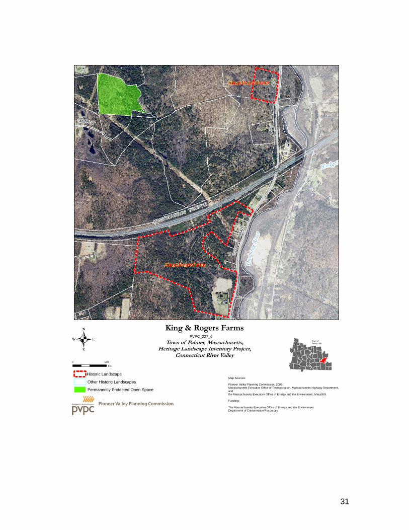
Robert Rogers and Jesse King Farms
Robert Rogers House Jesse King House The Rogers and King farms are located within a mile of each other on Boston Road in eastern Palmer. Historically contiguous, they both face east toward the Quaboag River. King Brook runs between them as it flows into the river. The Robert Rogers house appears to be the earlier of the two and is probably of mid-18th century construction. It is a center chimney, Georgian style house with small windows placed close to the eaves, which are clipped in the gable ends; it rests on low foundations, and has a simple vernacular entry surround. Its ell is thought to date as early as 1740. Robert Rogers Farm According to 1970s deed research by the Palmer Historical Commission, Robert Rogers bought the land on which the Rogers house is located in 1740. He and Jane Rogers built a house on the property that may later have become the west ell of this house and lived there with six children. The main block of the house was later added. From Robert and Jane the house went to their son John Rogers and his wife Jennie who had four children before John’s second wife Dorcas moved here and had four more children. Dorcas became the next owner and passed the farm to their son Oliver. Prior to Oliver’s death in 1837, his brother Reuben Rogers (1793-1883) took over the farm in 1834. Two years after Reuben’s death, in 1885, the house was sold out of the family. It is no longer actively farmed. There is a barn, garage and shed remaining on the property. Jesse King Farm The Jesse King house has been dated ca. 1793. The King house is conservative in its use of a center chimney, if its 1790s construction date is accurate. After the Revolution two interior chimneys were more commonly used. The exterior ornament of the house is as conservative as its center chimney - it is transitional between Georgian and Federal in style. The house has the Federal style’s larger windows, but its clipped eaves, elaborate pedimented entry surround and crown molding window lintels were all in use during the 1750s-1770s as features of the Georgian style. There is a 20th century outbuilding on the property, but no barns remain. Jesse King was the grandson of the first 1716 settlers of Palmer John and Sarah King, and the King family amassed a large acreage in this section of town. The land for the Jesse King house came down to him from his parents Aaron and Sarah King who bought 336 acres here in 1745. Jesse and Mary King settled on the land and lived in an earlier house
28

until they built this house ca. 1793. Jesse was active in town government as a selectman, a school committee member, and as a representative to the General Court from Palmer. The house stayed in the King family passing to Isaac and his wife Abby in 1832. Isaac was called “Colonel” for his service in the town militia. He was active in the church and town government. Their son Joseph King in 1875 took over the house and he and his wife Thankful raised three children here. In 1891 the house was sold out of the King family. The farm now consists of 276 acres and is not actively farmed.
Detail of Georgian style door surround, King House. Opportunities:
• The combination of these two 18th century houses on much if not all of their original farmland creates an intact 18th century landscape not found elsewhere in Palmer.
• Both houses are well-maintained and have been restored by their owners who
have devoted time to establishing their histories.
Landscape view northwest of King House. Issues:
• Neither house is formally protected and its future beyond the current generation is unknown.
• There is pressure for development in Palmer, which could threaten the extensive
landscapes associated with the houses.
29

Recommendations:
1. The Town might consider adopting Open Space Development Zoning for the area, so that if there were to be development on the landscape in the future it could be directed to places on the properties where it would not conflict with the historic views from Boston Road, and could be limited to a denser area to preserve as much open space as possible.
2. The Palmer Historical Commission should prepare thorough research on these
two properties and enter it on new MHC inventory forms as existing research is inadequate and sometimes confusing.
3. The Town should work with the owners to develop preservation plans for the
properties, and together they should explore working with state and regional land trusts to protect the properties’s landscapes through outright acquisition or purchase of conservation restrictions.
4. The two properties should be listed on the National Register of Historic Places as
an historic district.
5. The two properties would make a fine Local Historic District, which would protect them against inappropriate future changes. Single buildings can be Local Historic Districts, though there are outbuildings on each property.
30
BOS
TON
RO
AD
SMITH ST
MASSACHUSETTS TURNPIKE
0 1,000
Feet
Town ofPalmer, MA
Map Sources:
Pioneer Valley Planning Commission, 2009.Massachusetts Executive Office of Transportation, Massachusetts Highway Department,andthe Massachusetts Executive Office of Energy and the Environment, MassGIS.
Funding:
The Massachusetts Executive Office of Energy and the EnvironmentDepartment of Conservation Resources
King & Rogers Farms
Permanently Protected Open Space
Historic Landscape
Other Historic Landscapes
Town of Palmer, Massachusetts,Heritage Landscape Inventory Project,
Connecticut River Valley
PVPC_227_6
31

H. H. Richardson’s Union Station and Olmsted Park.
The railroad first came to Palmer in 1839 when the Western Railroad was constructed. It followed the Quaboag River and passed through what was at the time an agricultural landscape. A depot was built in 1839. By 1850 a second railroad line passed through Palmer, the New London Northern and Amherst, Belchertown and Palmer line, and a second depot was built at the same location. The presence of two railroad lines and growing textile mills in the town of Palmer brought about the growth of the area around the depot and it became known as Palmer Depot. Palmer Center ceded its position as the town’s civic center and Palmer Depot became the town’s civic and commercial center during the second half of the 19th century. Soon spur lines were established to connect Palmer’s mill villages. Among them was the Ware River Railroad that went from Palmer Depot north through Thorndike to Ware in 1870. By the end of the 1870s traffic for both freight and passengers had grown to the point that a new depot was needed and in 1881 the Boston and Albany Railroad, which had taken over the Western Railroad line, hired Brookline architect Henry Hobson Richardson to design sixty depots on its line including this one for Palmer. Frederick Law Olmsted’s landscape architecture firm, which was also based in Brookline, was given a contract to design landscapes for the depots. Palmer’s depot and landscape design may be seen as a part of the City Beautiful Movement that aimed to upgrade the country’s major cities to European standards. Richardson designed Union Station in the Romanesque Revival style, and Olmstead created a European-style grotto at one end of an undulating, oval-shaped lawn planted with trees and ferns and furnished with sidewalks and benches.
32

View of Olmsted stone arch and lawn, cal 1900. The station brought hotels, banks and stores to Palmer Depot to accommodate railroad travelers, and was a centerpiece for Palmer for many years until automobiles replaced trains for personal travel.
Main Street Palmer, postcard ca. 1900. When passenger service stopped in the 1970s, Union Station was used for businesses. The Boston and Albany was bought up by the New York Central in the 1960s and then by CSX which filled in the grotto and paved the lawn for freight use in the 1970s. In 1989 the station was bought by a private individual from the railroad and between 1998 and 2004 it was restored and rehabilitated as a restaurant, which is active today.
F. L. Olmsted-designed stone arch over grotto, now filled-in, 2009.
Opportunities: • Union Station is on the National Register of Historic Places and has been restored
over the past decade.
33
• The Station owner has a signed purchase and sale agreement to acquire the land that at one time was landscaped by F. L. Olmsted, so that it can be reconstructed.
• Engineering drawings and planting plans exist for the Olmsted work at the station
and could serve as plans for reconstruction of the landscape.
• The arch over the grotto may still be seen and there is evidence that arch and grotto remain intact beneath the fill brought in by the railroad.
• A Palmer gardening club’s members along with several master gardeners in the
town are willing to work on restoring and providing long-term maintenance of the landscape plantings specified by Olmsted for this park.
• Reconstruction of the landscape would once again provide a beautiful landscape
setting for the depot, which would help support the economic viability of the Station.
Issues:
• It is difficult to determine how much of the original structure of arch, grotto, and pool are extant under the tons of fill brought in to level out the rolling oval landscape.
• This is a very expensive project that does not have any apparent income-
producing capacities. Recommendations:
1. It is recommended that a Cultural Landscape Report be prepared that would compile in-depth research to determine the extent of the potential remnants of the grotto and propose potential treatment options. Some limited sub-surface testing might be warranted as part of the research.
2. If the Town were to adopt the Community Preservation Act, preservation
funding would be available to help support the reconstruction project, which would benefit the community and help the preservation efforts for the depot.
3. The owner might be able to qualify for a Transportation Enhancement
grant for the grotto, pond and arch, along with the grading work, once it is determined that they are both extant and restoration-worthy.
4. The Town might consider establishing a program to transfer development
rights so the landowner could sell the development rights attached to the landscape area as a means of raising funds for its reconstruction. The rights could be used for a targeted area of development to build at a greater density or height than are allowed through zoning.
34

5. The Town could work with local land trusts to arrange a purchase of
conservation restrictions on the landscape once it has been reconstructed, as a means of providing post-project funding to the owner for the work and assure its long-term landscape use.
THO
RN
DIK
E S
TREE
T
NORTH MAIN STREET
BR
EC
KE
NR
IDG
E S
TRE
ET
SOUTH MAIN STREET
KNO
X ST
REET
PINNEY STREET
CONVERSE STREET
PARK STREET
RA
ND
AL L
STR
EE
T
RIVERVIEW PARKWAY
SCHOOL STREE
T
HIG
H STR
EE
T
KIN
G ST
REET
OAKLAND STREET
BRIDGE
STREE
T
WATER
STREET
LONGVIEW STREET
SQUI
RE ST
REE
T
0 1,000
Feet
Town ofPalmer, MA
Map Sources:
Pioneer Valley Planning Commission, 2009.Massachusetts Executive Office of Transportation, Massachusetts Highway Department,andthe Massachusetts Executive Office of Energy and the Environment, MassGIS.
Funding:
The Massachusetts Executive Office of Energy and the EnvironmentDepartment of Conservation Resources
H.H. Richardson Railroad Station & F. L. Olmsted Park
Permanently Protected Open Space
Historic Landscape
Other Historic Landscapes
Town of Palmer, Massachusetts,Heritage Landscape Inventory Project,
Connecticut River Valley
PVPC_227_7
35

PART II: PLANNING FOR HERITAGE LANDSCAPES INVENTORY AND DOCUMENTATION 1. Massachusetts Historical Commission Records Current Listings: There are currently 687 properties listed from Palmer at the MHC. It includes seven Area Forms, mill workers’s housing, commercial buildings, farms, cemeteries and more. The Palmer Historical Commission has continued to add to its inventory with 20th century properties, namely a diner on Main Street and a church in Three Rivers, but there is more to accomplish. The forms are partially accessible through the MACRIS data base available on the MHC website. Recommendations: The Palmer Historical Commission should continue to add properties to its survey, and maintain the survey as up-to-date. The new forms should be prepared in digital format and when possible the old forms should be re-done in the new digital format as well. 2. National and State Register Listing Current Listings: There are three individual buildings listed on the National Register in Palmer: the Union Station depot, the U. S Post Office and the Palmer Memorial Hall. There are no historic districts listed on the National Register in Palmer Recommended Listings: It is recommended that the Palmer Historical Commission list each of its villages including the mills, mill workers’s housing, streetscapes, canals, commercial districts, civic buildings, and cemeteries on the National Register. It is also recommended that the King and Rogers Farms be listed as a Local Historic District to offer them the greatest protection available. 3. Heritage Landscape Inventory List from Local Identification Meeting Each town involved in the Connecticut River Valley Landscape Inventory held a local identification meeting to solicit input from a range of community members to identify potential heritage landscapes throughout the town. The lists were prioritized by the community, with help from the consultants, to create a list of five to ten priority areas, which were described in Part I of this report. The complete list of the town’s heritage landscapes provides a sound resource list for future documentation activities and potential funding opportunities. • Agricultural • Archaeological/Ethnographic• Burial • Civic • Industrial • Institutional • Transportation • Natural • Open Space and Recreation • Residential • Commercial
36

TOWNWIDE PLANNING AND ZONING TOOLS AND TECHNIQUES Detailed descriptions of planning tools and techniques can be found in the Department of Conservation and Recreation Terra Firma #7 – Taking Action: A Toolkit for Protecting Community Character (2009). This document includes the following sections: Municipal Roles in Landscape Preservation; Thinking in Context: Comprehensive and Open Space Planning; Engaging the Public; and Defending the Resources: Laws, Bylaws and Regulations. This document should be used in conjunction with this report as a guide to acting on the specific recommendations for Priority Heritage Landscapes included in Part I. The following Community Planning Checklist provides an overview of planning and zoning that currently exists within the town of Palmer, zoning changes that are currently underway, and recommendations for further changes that were included in this report and other planning documents. COMMUNITY PLANNING CHECKLIST TOWN OF PALMER
IMPLEMENTATION
STATUS
BUILDING BLOCK
NOTES
Traditional Neighborhood Development (TND) Transit Oriented Development (TOD) Mixed Use Village Districts
Planned Unit Development (PUD) Adaptive Reuse and Infill Development Thorndike Mills
Tax Incentive Programs and Business Improvement Districts
Open Space Residential Development Extend to Jesse King and Robert Rogers Farms
Accessory Apartments Inclusionary Zoning Home Based Business Bylaw Brownfields Inventory
Brownfields Redevelopment Projects Transfer of Development Rights H.H. Richardson’s Union Station and
Olmsted Park Agricultural Commissions Right to Farm Bylaws
River Protection Overlay District Community Preservation Act Could be used to fund preservation of
all high priority landscapes. Scenic Upland Overlay District Bike and Pedestrian Features
Traffic Calming Measures Water Supply Protection District Low Impact Development Stormwater and Erosion Control Bylaw Stormwater Utilities
37

Commercial Site Plan Review Commercial Performance Standards
Urban Growth Boundaries / Limits of Sewer and Water Extensions
Green Building Standards Municipally Owned Renewable Energy Adoption of Smart Growth Zoning Districts
(Ch. 40R)
Intergovernmental Compact + Valley Vision MOA Planning Board Assistance Program Local Historic District / National Register of
Historic Places Fishing Weir; Thorndike Mills; Old
Center Cemetery; Jesse King and Robert Rogers Farms
Architectural Preservation District/ Archaeological Resource Protection Bylaw
Fishing Weir; the Shaw District
Demolition Delay Bylaw Scenic Roads Bylaw/Designation Nipmuck Road and more.
Successfully Implemented Considering Should Consider Adopting
Comprehensive, Open Space and Other Planning Documents It is important that Open Space Plans, Comprehensive or Master Plans, and other planning documents address heritage landscapes as vital features of the community, contributing not only to unique sense of place, but also to environmental, recreational and economic health. Current Plans: Palmer currently has three plans. There is a Community Plan, dated June 2004, an Open Space and Recreation Plan, from 2006, and a Local Natural Hazards Mitigation Plan, from June of 2008. Recommended Plans: It is recommended that a comprehensive or master plan be prepared for Palmer. Comprehensive planning provides an important frame of reference for a town’s land use decisions and incorporates all of a community’s issues into an integrated plan. Heritage Landscapes need to be made a part of the comprehensive plan since the town uses the plan to guide its activities related to community character, historic preservation, environmental health, economic viability and growth. The future of the Heritage Landscapes and the values they contribute should be addressed within multiple perspectives, not solely as historical assets of the community. IMPLEMENTATION STRATEGIES Outreach, Education and Interpretation In order to create a community of advocates, we need to raise public awareness and broaden the base of support. This includes developing opportunities to learn about and celebrate the places and history of the town, as well as to care for them.
38
Collaboration Protecting community character, respecting history, and promoting smart growth are interrelated concerns that impact heritage landscapes and require collaboration across a broad spectrum of the community. This includes communication among town boards and departments, as well as public-private partnerships. Technical Assistance
Regulations and creative solutions for heritage landscapes are constantly changing and emerging. Public and private agencies offer technical assistance with the many issues to be addressed, including DCR, MHC, the Pioneer Valley Planning Commission and the Franklin Regional Council of Governments.
Technical assistance for developing a CPA campaign, or hosting a CPA informational session, can be obtained from Jay Rasku, Coordinator of the North Quabbin Regional Landscape Partnership (NQRLP). Working with the Community Preservation Coalition, the NQRLP is a regional partner that has been working with municipalities to help meet technical assistance needs in the field. The North Quabbin Regional Landscape Partnership can be reached at: info@nqpartnership or at 978-248-2118. More information about the Community Preservation Coalition can be found at: www.communitypreservation.org.
Funding Opportunities Funding rarely comes from a single source, more often depending on collaborative underwriting by private, municipal, and regional sources. Each town also has a variety of funding sources that are locally-based and sometimes site-specific. The Community Preservation Act is one of the new and successful Commonwealth programs to provide funding from several sources for towns and cities. It would provide Palmer an important source of funding for its Heritage Landscapes. CONCLUSION The Heritage Landscape Reconnaissance Report for Palmer has undertaken an analysis of the priority heritage landscapes identified by the community, their place in the town’s history and how the town might approach their preservation and conservation. But many of the report’s recommendations can also be applied to the landscapes forming the master list, and – as the master list is by no means exhaustive - to those heritage landscapes that are yet to be identified. One of the most important starting points for protecting Palmer’s heritage landscapes is to do further research on all the properties that have been identified. And the best way to do that, is to bring the inventory up to date. Once the inventory work has been sufficiently established the overall context in which the landscapes exist are more easily
39
described and their importance conveyed to town residents, town government members, and to the Massachusetts Historical Commission. To capitalize on the work in progress, it is important to use this report to alert town government members, committees and commissions to the existence and value of the town’s heritage landscapes, so distribution and discussion of the report will be an important next move. This is all part of generating community support, and community support is essential to preserving the town’s heritage, be it an archaeological site, historic farms, cemeteries or Native American artifact. Publicizing the report through a series of articles, presentations, and making it available to residents will be an important effort. Creating public awareness is vital towards educating the public and this can be achieved through the schools, libraries, the media, on-line and special events. Above all, leading the community to recognize that it does indeed have heritage landscapes and that they make up the town’s attractive character is a goal that this report can help accomplish. The three top recommendations for Palmer are 1. prepare National Register nominations for the Town’s mill villages and areas of concentrated historic properties 2. focus on developing protection for the Native American weir and its use as an educational site on a trail 3. adopt the Community Preservation Act to facilitate these and many of the other worthy preservation projects. RESOURCES Reading the Land Massachusetts Heritage Landscape a Guide to Identification and Protection, Department of Conservation and Recreation, Executive Office of Energy and Environmental Affairs, 2008 Terra Firma #1- An Introduction to Historic Landscape Preservation Department of Conservation and Recreation Executive Office of Environmental Affairs, n.d. Terra Firma #3- Putting Historic Landscape Preservation on Sold Ground: Identifying and Protecting Historic Roads, Department of Conservation and Recreation, Executive Office of Energy and Environmental Affairs, n.d. Terra Firma #5 Putting Heritage Landscape Preservation on Solid Ground: Stones that Speak: Forgotten Features of the Landscape, Department of Conservation and Recreation, Executive Office of Environmental Affairs, n.d. Terra Firma #7 - Taking Action: A Toolkit for Protecting Community Character Department of Conservation and Recreation Executive Office of Energy and Environmental Affairs, 2009. Massachusetts Historical Commission. Preservation through Bylaws and Ordinances, Draft Copy March 11, 2009, typescript. ____________________________. MHC Reconnaissance Survey Reports, typescript, 1982.
40
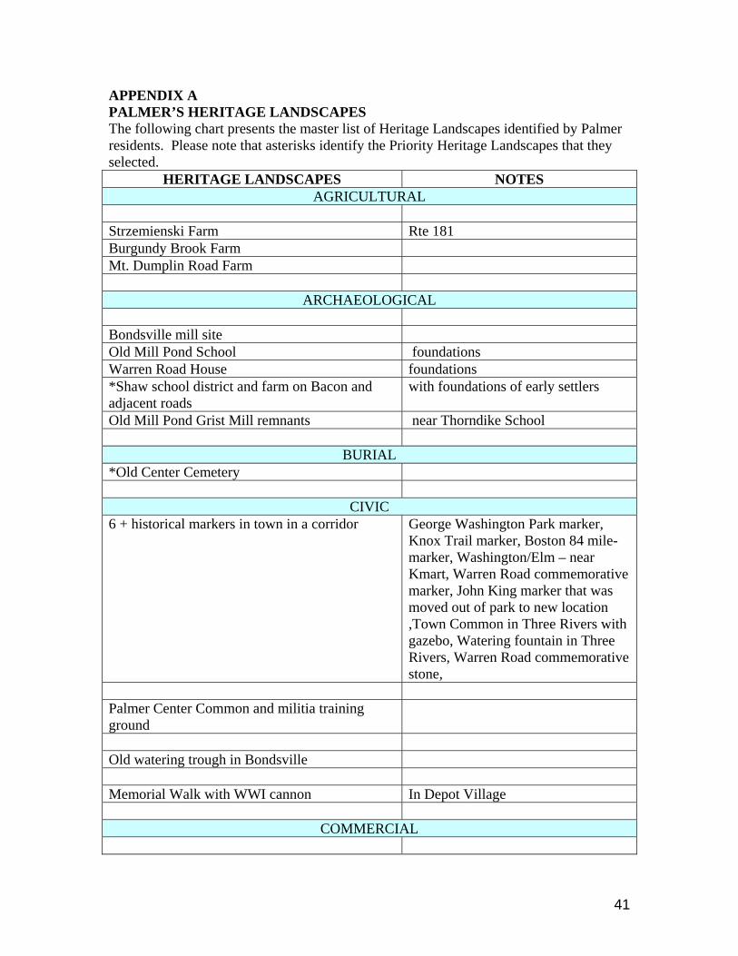
APPENDIX A PALMER’S HERITAGE LANDSCAPES The following chart presents the master list of Heritage Landscapes identified by Palmer residents. Please note that asterisks identify the Priority Heritage Landscapes that they selected.
HERITAGE LANDSCAPES NOTES AGRICULTURAL
Strzemienski Farm Rte 181 Burgundy Brook Farm Mt. Dumplin Road Farm
ARCHAEOLOGICAL Bondsville mill site Old Mill Pond School foundations Warren Road House foundations *Shaw school district and farm on Bacon and adjacent roads
with foundations of early settlers
Old Mill Pond Grist Mill remnants near Thorndike School
BURIAL *Old Center Cemetery
CIVIC 6 + historical markers in town in a corridor George Washington Park marker,
Knox Trail marker, Boston 84 mile-marker, Washington/Elm – near Kmart, Warren Road commemorative marker, John King marker that was moved out of park to new location ,Town Common in Three Rivers with gazebo, Watering fountain in Three Rivers, Warren Road commemorative stone,
Palmer Center Common and militia training ground
Old watering trough in Bondsville Memorial Walk with WWI cannon In Depot Village
COMMERCIAL
41

Holden Block in downtown Palmer Fish Hatchery On Route 32 *Ice House Pond with piers & foundations
ETHNOGRAPHIC *Native American Fish Weir in Three Rivers Indian campground Near weir, but unknown location
INDUSTRIAL *Thorndike Mills Old dam on Chicopee River Former mill yard near Depot Two granite quarries on Willow Street near High Street
whose stone was used in Palmer buildings
INSTITUTIONAL
St. Bartholomew’s Church in Bondsville Second Congregational Church in Thorndike (now Baptist)
NATURAL Crystal Lake a kettle pond off 181 Lake Thompson and its floating bog View from and of Mt. Dumplin Confluence of Four Rivers Swift, Chicopee, Ware and Quaboag
Rivers all join at single area. Potential vista from downtown Palmer now blocked by signs
OPEN SPACE Forest Lake 19TH century recreational destination,
now open space Lover’s Lane at Forest Lake A walking path at Forest Lake
42

43
RECREATIONAL
Camp Ramah Wall Trail along Chicopee River to Ludlow
TRANSPORTATION *H. H. Richardson-designed Union railroad depot with Olmsted-designed park
Nipmuck Road with its stone walls Old trolley line berm past Forest Lake