Embed Size (px)
Citation preview
IOP Conference Series: Earth and Environmental Science
PAPER • OPEN ACCESS
Ecological Approach as an Urban Solution for Sensitive AreasTo cite this article: Ana Virtudes et al 2019 IOP Conf. Ser.: Earth Environ. Sci. 221 012153
View the article online for updates and enhancements.
This content was downloaded from IP address 139.81.40.235 on 01/03/2019 at 17:25
Content from this work may be used under the terms of the Creative Commons Attribution 3.0 licence. Any further distributionof this work must maintain attribution to the author(s) and the title of the work, journal citation and DOI.
Published under licence by IOP Publishing Ltd
World Multidisciplinary Earth Sciences Symposium (WMESS 2018)IOP Conf. Series: Earth and Environmental Science 221 (2019) 012153
IOP Publishingdoi:10.1088/1755-1315/221/1/012153
1
Ecological Approach as an Urban Solution for Sensitive Areas
Ana Virtudes 1, Nina Kakosova 2, Nikoleta Filippidi 3, Ana Carrico 4 1 CIAUD, Research Centre for Architecture, Urbanism and Design, University of Lisbon, Portugal 2 Slovak University of Technology, Faculty of Architecture, Slovakia 3 Technical University of Crete, School of Architecture, Greece 4 Municipality of São Pedro do Sul, Portugal
Abstract. The urban spaces of river banks are sensitive areas, not only in environmental terms but also considering the spatial planning rules. Often the spatial planning rules are focused on building and urban development questions rather than of ecological approaches. In this sense, this article aims to present an urban design project for a sensitive territory of river banks having as pivotal concern ecological solutions. This proposal is due to the requirement of linking the landscape features of river water fronts with the characteristics of the urban fabric. The case study area is the Train Station surroundings in São Pedro do Sul, a city in the central region of Portugal very well-known because of its thermal baths. It was proposed to the university team, on behalf of the Urban Planning Unit of the Master Degree in Architecture at the University of Beira Interior, by the Municipal authority. The students were organized in groups in order to propose the urban design projects, ensuring the continuity of the urban fabric with the Vouga river. The best projects won prizes (1st, 2nd and two honour awards) offered by the city hall. This fact was an extra motivation for students along to the design process in an academic environment comprising an international background (including Portugal, Greece, Brazil, Slovakia, Lithuania and Poland). Regarding the presented solution, the conclusions show that the main strategy was to preserve and to enhance the ecological identity of the place, possible given the agreement in between university and municipal authority, working together.
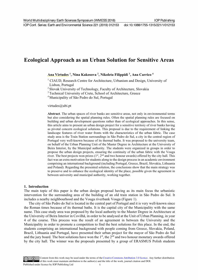
1. Introduction The main topic of this paper is the urban design proposal having as its main focus the urbanistic intervention for the surrounding area of the building of an old train station in São Pedro do Sul. It includes a nearby neighbourhood and the Vouga riverbank Vouga (Figure 1).
The city of São Pedro do Sul is located in the central part of Portugal and it is very well-known since the Roman times because of its thermal baths. It is the capital city of the Municipality with the same name. This case study area was proposed by the local authority to the Master Degree in Architecture at the University of Beira Interior in Covilhã, in order to be analysed at the Unit of Urban Planning, in year 4 of the course. This process was the result of an agreement in between the University and the Municipality in order to promote a competition to find the best solutions for this place. In the end, the students comprising an international background with people coming from Greece, Slovakia, Poland, Brazil, Lithuania and Portugal, have presented their urban project for the mayor of São Pedro do Sul and the jury board. The best solutions have won the 1st, the 2nd and two honour monetary awards offered by the city hall. The winner was the proposals presented by a group of ERASMUS Polish students
World Multidisciplinary Earth Sciences Symposium (WMESS 2018)IOP Conf. Series: Earth and Environmental Science 221 (2019) 012153
IOP Publishingdoi:10.1088/1755-1315/221/1/012153
2
coming from the Cracow University of Technology [1] This competition and the international exchange environment at the class room were extra motivations for students along to the design process.
Figure 1. Localization of the case study area: Train station surroundings in São Pedro do Sul.
2. The train station surroundings in São Pedro do Sul
2.1. Main features In the urban design process, the main challenge to face was to coming up with new forms of organization of the existing urban fabric, linking to the river water front. According to the São Pedro do Sul Master Plan for the municipality as a whole, this area near to the Vouga river is protected in terms of maintaining the natural environment. The river is an important ecological “corridor” with various species of local fauna and flora. Therefore, these requirements had to be followed while proposing new urbanistic solutions. According to the Municipal Master Plan of São Pedro do Sul [2], the main important figure of plan of the Portuguese spatial planning system (there are all over the country 308 master plans [3] [4], one for each municipality), one part is included at the agriculture purposes reserve [5]. In this sense, this working team, was mainly focused on attracting the inhabitants of São Pedro do Sul to this part of the town, along with visitors coming here to enjoy the place, which is very well-known for its hot streams and thermal baths, thus the visitors have the addition to the existing facilities. The main objective is to help to fulfil its recreational potential, enjoying outdoor activities connected with the river. The case
World Multidisciplinary Earth Sciences Symposium (WMESS 2018)IOP Conf. Series: Earth and Environmental Science 221 (2019) 012153
IOP Publishingdoi:10.1088/1755-1315/221/1/012153
3
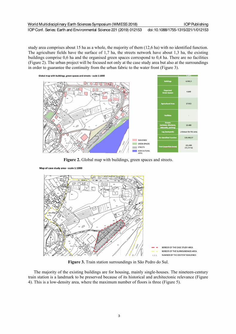
study area comprises about 15 ha as a whole, the majority of them (12,6 ha) with no identified function. The agriculture fields have the surface of 1,7 ha, the streets network have about 1,3 ha, the existing buildings comprise 0,6 ha and the organised green spaces correspond to 0,4 ha. There are no facilities (Figure 2). The urban project will be focused not only at the case study area but also at the surroundings in order to guarantee the continuity from the urban fabric to the water front (Figure 3).
Figure 2. Global map with buildings, green spaces and streets.
Figure 3. Train station surroundings in São Pedro do Sul. The majority of the existing buildings are for housing, mainly single-houses. The nineteen-century
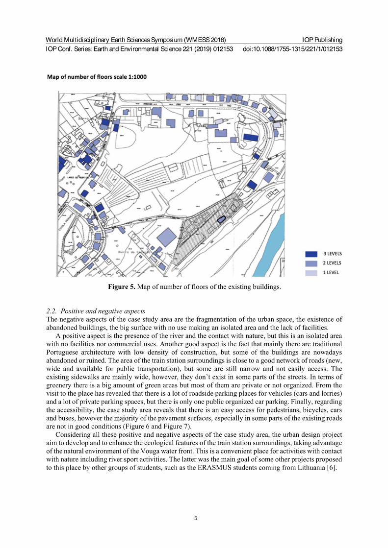
train station is a landmark to be preserved because of its historical and architectonic relevance (Figure 4). This is a low-density area, where the maximum number of floors is three (Figure 5).
World Multidisciplinary Earth Sciences Symposium (WMESS 2018)IOP Conf. Series: Earth and Environmental Science 221 (2019) 012153
IOP Publishingdoi:10.1088/1755-1315/221/1/012153
4
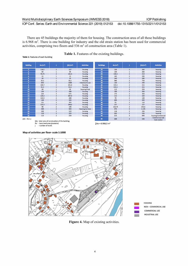
There are 45 buildings the majority of them for housing. The construction area of all these buildings is 6.968 m2. There is one building for industry and the old strain station has been used for commercial activities, comprising two floors and 536 m2 of construction area (Table 1).
Table 1. Features of the existing buildings.
Figure 4. Map of existing activities.
World Multidisciplinary Earth Sciences Symposium (WMESS 2018)IOP Conf. Series: Earth and Environmental Science 221 (2019) 012153
IOP Publishingdoi:10.1088/1755-1315/221/1/012153
5
Figure 5. Map of number of floors of the existing buildings.
2.2. Positive and negative aspects The negative aspects of the case study area are the fragmentation of the urban space, the existence of abandoned buildings, the big surface with no use making an isolated area and the lack of facilities.
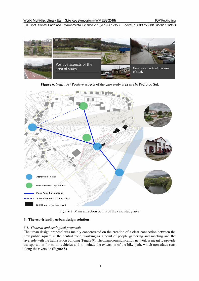
A positive aspect is the presence of the river and the contact with nature, but this is an isolated area with no facilities nor commercial uses. Another good aspect is the fact that mainly there are traditional Portuguese architecture with low density of construction, but some of the buildings are nowadays abandoned or ruined. The area of the train station surroundings is close to a good network of roads (new, wide and available for public transportation), but some are still narrow and not easily access. The existing sidewalks are mainly wide, however, they don’t exist in some parts of the streets. In terms of greenery there is a big amount of green areas but most of them are private or not organized. From the visit to the place has revealed that there is a lot of roadside parking places for vehicles (cars and lorries) and a lot of private parking spaces, but there is only one public organized car parking. Finally, regarding the accessibility, the case study area reveals that there is an easy access for pedestrians, bicycles, cars and buses, however the majority of the pavement surfaces, especially in some parts of the existing roads are not in good conditions (Figure 6 and Figure 7).
Considering all these positive and negative aspects of the case study area, the urban design project aim to develop and to enhance the ecological features of the train station surroundings, taking advantage of the natural environment of the Vouga water front. This is a convenient place for activities with contact with nature including river sport activities. The latter was the main goal of some other projects proposed to this place by other groups of students, such as the ERASMUS students coming from Lithuania [6].
World Multidisciplinary Earth Sciences Symposium (WMESS 2018)IOP Conf. Series: Earth and Environmental Science 221 (2019) 012153
IOP Publishingdoi:10.1088/1755-1315/221/1/012153
6
Figure 6. Negative / Positive aspects of the case study area in São Pedro do Sul.
Figure 7. Main attraction points of the case study area.
3. The eco-friendly urban design solution
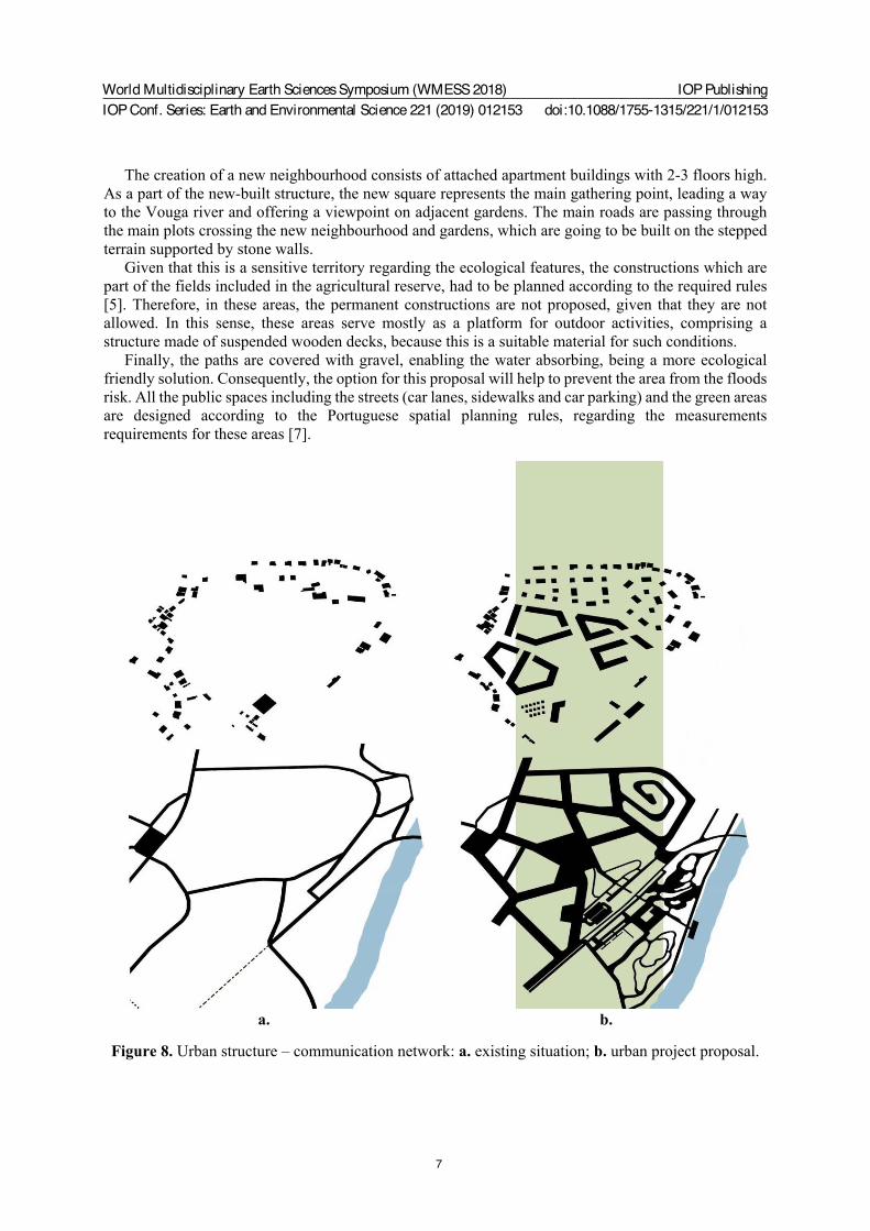
3.1. General and ecological proposals The urban design proposal was mainly concentrated on the creation of a clear connection between the new public square in the central zone, working as a point of people gathering and meeting and the riverside with the train station building (Figure 9). The main communication network is meant to provide transportation for motor vehicles and to include the extension of the bike path, which nowadays runs along the riverside (Figure 8).
World Multidisciplinary Earth Sciences Symposium (WMESS 2018)IOP Conf. Series: Earth and Environmental Science 221 (2019) 012153
IOP Publishingdoi:10.1088/1755-1315/221/1/012153
7
The creation of a new neighbourhood consists of attached apartment buildings with 2-3 floors high. As a part of the new-built structure, the new square represents the main gathering point, leading a way to the Vouga river and offering a viewpoint on adjacent gardens. The main roads are passing through the main plots crossing the new neighbourhood and gardens, which are going to be built on the stepped terrain supported by stone walls.
Given that this is a sensitive territory regarding the ecological features, the constructions which are part of the fields included in the agricultural reserve, had to be planned according to the required rules [5]. Therefore, in these areas, the permanent constructions are not proposed, given that they are not allowed. In this sense, these areas serve mostly as a platform for outdoor activities, comprising a structure made of suspended wooden decks, because this is a suitable material for such conditions.
Finally, the paths are covered with gravel, enabling the water absorbing, being a more ecological friendly solution. Consequently, the option for this proposal will help to prevent the area from the floods risk. All the public spaces including the streets (car lanes, sidewalks and car parking) and the green areas are designed according to the Portuguese spatial planning rules, regarding the measurements requirements for these areas [7].
a. b.
Figure 8. Urban structure – communication network: a. existing situation; b. urban project proposal.
World Multidisciplinary Earth Sciences Symposium (WMESS 2018)IOP Conf. Series: Earth and Environmental Science 221 (2019) 012153
IOP Publishingdoi:10.1088/1755-1315/221/1/012153
8
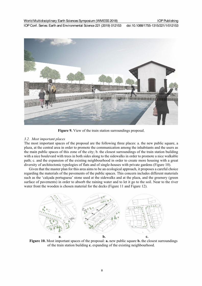
Figure 9. View of the train station surroundings proposal.
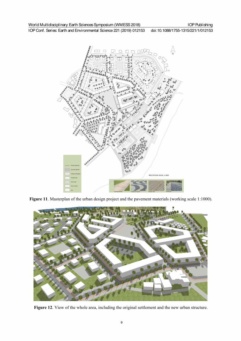
3.2. Most important places The most important spaces of the proposal are the following three places: a. the new public square, a plaza, at the central area in order to promote the communication among the inhabitants and the users as the main public spaces of this zone of the city; b. the closest surroundings of the train station building with a nice boulevard with trees in both sides along to the sidewalks in order to promote a nice walkable path; c. and the expansion of the existing neighbourhood in order to create more housing with a great diversity of architectonic typologies of flats and of single-houses with private gardens (Figure 10).
Given that the master plan for this area aims to be an ecological approach, it proposes a careful choice regarding the materials of the pavements of the public spaces. This concern includes different materials such as the ‘calçada portuguesa’ stone used at the sidewalks and at the plaza, and the greenery (green surface of pavements) in order to absorb the raining water and to let it go to the soil. Near to the river water front the wooden is chosen material for the decks (Figure 11 and Figure 12).
a. b. c.
Figure 10. Most important spaces of the proposal: a. new public square b. the closest surroundings of the train station building c. expanding of the existing neighbourhood.
World Multidisciplinary Earth Sciences Symposium (WMESS 2018)IOP Conf. Series: Earth and Environmental Science 221 (2019) 012153
IOP Publishingdoi:10.1088/1755-1315/221/1/012153
9
Figure 11. Masterplan of the urban design project and the pavement materials (working scale 1:1000).
Figure 12. View of the whole area, including the original settlement and the new urban structure.
World Multidisciplinary Earth Sciences Symposium (WMESS 2018)IOP Conf. Series: Earth and Environmental Science 221 (2019) 012153
IOP Publishingdoi:10.1088/1755-1315/221/1/012153
10
4. Conclusions Regarding the presented urban design solution, the conclusions show that the main followed strategy in order to preserve the connection in between the urban fabric and the Vouga river was to use ecological materials and a low-density built structure. In parallel, there was the concern of to establish a good and direct connection in between the most important places, the river, the train station and the public main square, creating places where people can stay together, having a contact with nature with a wonderful view over the bucolic landscape of the water front.
With this urban design solution is possible to preserve and to enhance the ecological identity of the place, as a touristic attraction and including the traditional presence of the water. This objective is due not only because of the existing hot streams and thermal baths, but also because of the proposed urban link with the river water front.
Finally, the experience of study an area in a Portuguese city in an international team environment and with the support of the local authority, the Municipality od São Pedro do Sul, had as result a deeper knowledge of the previous features of the place and a wider understanding of the opportunity of the proposed solutions.
Acknowledgments This publication was supported by the CIAUD, the Research Centre for Architecture, Urbanism and Design, University of Lisbon, financed by FCT, the Portuguese Foundation for Science and Technology.
References [1] Virtudes, A., Debicka, A., Janik, L., Barwinska, M., Choinacka, N., Carriço, A., (2018) “Soft
Mobility as an urban design solution for water fronts”, in WMESS18. World Multidisciplinary Earth Sciences Symposium, 3-7 September, Prague, Czech Republic.
[2] Municipal Master Plan of São Pedro do Sul, D.R. no. 237, 13 October 1995. [3] Law-Regime of the Portuguese Spatial Planning System, D.L. no. 380/99, 22 September. [4] Law-Regime of the Portuguese Policy of Land Uses, Spatial Planning and Urbanism, D.L. no.
80/2015, 14 May. [5] Law-Regime of the Portuguese National Reserve for Agriculture Purposes, D.L. no. 73/2009, 31
March. [6] Virtudes, A., Palaitytè, G., Liaudnskaitè, M., Svarauskaitè, D., Carriço, A. (2018) “An urban
design project focused on river sports”, in WMESS 18, 4th World Multidisciplinary Earth Sciences Symposium, 3-7 September, Prague, Czech Republic.
[7] Law-Regime of Portuguese Requirements for Public Spaces Measurements, Portaria no. 218-B/2008.