Embed Size (px)
Citation preview
Technical Evaluation of Potential Public Access Alignments for the Giacomini Wetland Restoration Project
Part II: Technical Feasibility Study
LandPeople 19 7/12/2005 landscape architects and planners
3.0 STUDY RESULTS
This section presents the overall and site-specific results of the study. The descriptions of the trail alternatives are generally taken from the Phase I Technical Study, with amendments reflecting public input and refinement during Phase II: 3.1 DESIGN AND ANALYSIS ASSUMPTIONS This study is not intended to resolve all design issues and details for public access, but to provide a realistic set of concepts for the configuration of the trail along the given alignments upon which to base construction and maintenance cost estimates, and to help identify land use impacts. Based on public input, input from the Park Service and Marin County, trail and roadway design standards, and the judgment of the consultants, some recommendations and assumptions about design have been built into the study.
3.1.a General Trail Types The trail design types vary significantly along the alignments, particularly on those alignments that follow the road shoulder. The objective was to balance compliance with applicable Marin County, state and federal standards while responding to local preferences. In general, to minimize environmental impact and to reflect community preferences the study evaluates a 6’ wide trail, except in locations where potential wetlands and/or slope conditions require use of a boardwalk, or in the Caltrans right-of-way, and the trail is part of a through route. In these cases the boardwalk may be 6’ wide because there is some adjacent usable level land on which to construct the remainder of the 8’ wide trail, or 8’ wide when there is not.
3.1.b Trail Users In general the trail connections are assumed to be multi-use, but the use assumptions vary between alignments. Alignment 1a, a boardwalk that ends at Lagunitas Creek, is assumed to be for pedestrians only (including handicapped access). Alignment 2c, the railroad grade, is assumed to accommodate hikers and equestrians. Alignments 4a- I and II, and 4d are assumed to accommodate pedestrians, bicyclists, and equestrians. Alignments 4a- III, 4b, and 4c are assumed to accommodate pedestrians and bicyclists.
3.1.c Trail Width As noted above, the trail width desired by local residents is 6’. In many locations construction of even this relatively narrow trail will impact potential wetlands and riparian vegetation and involve expensive construction methods. One option to reduce trail environmental impact and construction cost is to further reduce the width of the trail. However, for a multi-use path 6’ is already below standard. Any further width reduction is not recommended where the trail is part of a through route, except if unavoidable at specific obstacles. In any case the width should not be less then 5’ (for comparison the minimum Caltrans standard multi-use path is 8’ wide with 1’ clearance from adjacent objects, and Marin County Public Works has requested that the minimum trail width be
Technical Evaluation of Potential Public Access Alignments for the Giacomini Wetland Restoration Project
Part II: Technical Feasibility Study
LandPeople 20 7/12/2005 landscape architects and planners
8’). In the Caltrans right-of-way of Highway 1 (part of Alignment 4d/4e) the trail is designed and estimated at 8’ wide. The presence of fences or railings adjacent to the trail reduces the effective width, particularly in situations where there will be fences or railings on both sides. Fences or railings won’t allow clearance for bicycle handlebars, horses and riders, etc. Compared to a trail with no barriers on the side, the trail will be effectively one foot narrower anywhere there is an adjacent barrier. The concepts and estimates assume the trail will be 7’ wide where there is a fence or railing on one side, and 8’ wide where there is a fence or railing on 2 sides, except adjacent to guardrails, as explained below.
3.1.d Trail Surface Most residents who have commented on the trail concepts, such as the Community Pathways Committee’s statement for the NPS public workshop on access, have requested an informal decomposed granite (D.G.) trail surface, such as the existing trails in White House Pool Park. Although desirable for its informal natural appearance, D.G. does not necessarily provide a durable trail surface and does not comply with handicapped access standards for transportation (as opposed to rural recreation) facilities or for bike route use. One alternative is to apply a pine resin binder to the D.G., which if used properly creates a surface that is actually 3 times harder than asphalt. Unfortunately, this treatment is more expensive than asphalt, and approaches the cost of concrete. A stable, all-weather trail section could be constructed by clearing grading and compacting the trail surface, and placing a 6 to 8” layer of compacted base rock (Caltrans Class II aggregate base) with a 2” layer of gold-colored decomposed granite (D.G.) added. Alternatively, 3” of asphaltic concrete pavement could be placed in lieu of the D.G. This is assumed to be the case in the right-of-way of Highway 1, where it may be difficult to secure Caltrans approval for an alternative material. At intervals, assumed to be every few hundred feet in the cost estimate, culverts would need to be placed under the path to allow surface and ground water to pass. In particularly wet areas, laying geotextile fabric under the base rock will help stabilize the subgrade. In some cases, such as parts of Alignment 2c on the historic railroad grade, it may not be necessary or appropriate to construct an improved all-weather trail. A weather-dependant trail improvement alternative with no additional formal surfacing is evaluated. The cost estimate for this alternative includes clearing or trimming of encroaching vegetation, minor drainage improvements consisting of ditch work and an occasional culvert, localized surfacing such as base rock placed in wet locations, and an allowance for trail signs. While potentially suitable for recreational purposes, this weather-dependant trail type is not suitable as a transportation route because it does not comply with handicapped access standards or standards for a bicycle route facility.
3.1.e Safety Setbacks and Barriers Many project area residents have expressed the desire for a trail separated from the roadway, or if a separate trail isn’t feasible, for a safety barrier between the trail and the
Technical Evaluation of Potential Public Access Alignments for the Giacomini Wetland Restoration Project
Part II: Technical Feasibility Study
LandPeople 21 7/12/2005 landscape architects and planners
road. To meet standards and to accommodate utility poles the minimum setback from the edge of the traveled lane to the trail is 5’ in the concept designs. Some trail users may not consider this an adequate separation without a barrier. The design and location of a trail safety barrier requires careful consideration. The barrier could be a prefabricated or site-built concrete “K-rail” or “Jersey barrier” such as those typically seen on freeways, or a wood post and steel beam guardrail formerly used on state highways, and still used on some County roads. Alternatively, a 4’ chain link fence could serve as a barrier, providing minimal protection from errant vehicles, but preventing trail users (e.g. kids, dogs, and horses) from veering into the road. This is not assumed to be an acceptable safety barrier. Placing a barrier immediately adjacent to the road might present a hazard for vehicles that needed to make a sudden correction, or for bicyclists using the roadway that needed to make an evasive maneuver or just get off the road, and might present an obstacle for oversize vehicles. Marin County road standards call for a minimum of 4’ of shoulder beyond the edge of the lane, and depending on site-specific conditions, as much as 8’ of shoulder could be required.2 Caltrans and County standards call for a safety barrier between the road and the trail in any location where the edge of the trail would be within 5’ from the traveled lane. Marin County Public Works Department has requested that the safety barrier consist of a steel beam guardrail on wood posts located at least 5’ clear of the traveled lane. Placing lengths of concrete safety barrier along local roads would have a potentially significant adverse impact on scenic resources, including the ability to see the wetlands areas from autos. A post and beam guardrail would be less visually obtrusive and less obstructive to views, but would be less effective for safety and more expensive to maintain than a pre-cast K-rail type barrier. The estimates include an alternative for a guardrail safety barrier in locations where the trail is adjacent to the road, and the road shoulder is not reserved for turnouts, parking and/or access, such as in the community of Inverness Park. The County-recommended guardrail, which is approximately 20” wide in cross-section and 28” high, would be located 5’ clear of the traveled lane.3 An additional 2’ of trail width is provided in the guardrail estimate, with a corresponding increase in construction cost and construction area impact. The 2’ allowance for the guardrail provides approximately 4” clearance from the edge of the trail. Based on the 4” clearance, and the fact that the guardrail has a low height, additional setback between the trail and the guardrail is not deemed necessary. Where the outside edge of the trail would be adjacent to a drop-off created by a retaining wall or cantilevered boardwalk section, the design concepts and estimates include a 4’ high chain link fence/safety railing. The fence fabric would be coated with black or green
2 Eric Steger, Marin County Public Works Department, personal communication, April 14, 2005 3 Note that this assumed 5’ setback may not be acceptable to Caltrans or Marin County in some locations, with corresponding impacts on the wetlands and cost of trail construction.
Technical Evaluation of Potential Public Access Alignments for the Giacomini Wetland Restoration Project
Part II: Technical Feasibility Study
LandPeople 22 7/12/2005 landscape architects and planners
vinyl to make it less visually obtrusive and somewhat more durable. As noted above under “Trail Width” the trail is assumed to be 1’ wider adjacent to these barriers.
3.1.f Bridges Bridges are assumed to be prefabricated trail bridge structures with an 8’ width where they are in the road right-of-way and a 6’ width where they are not (at Alignment 1a and Alignment 4a in White House Pool Park). Where 50’ long or less, they are assumed to be fiberglass, a very low-maintenance alternative. The 200’ long bridge at the old summer dam location (Alignment 4a) is assumed to be 8’ wide steel, due to the increased structural requirements. It is assumed to be both galvanized and powder coated for durability in the salt air exposure.
3.1.g Utility Pole Relocation Along some of the alignments there are utility poles, often located 3 to 4 feet from the edge of the roadway where they will not interfere with the available space for the trail, but sometimes located 8 to 13 feet from the roadway where they would interfere with the available trail space. It is generally feasible to have utility poles relocated, but they may not be relocated closer to the road than 5’ due to Marin County road standards and general safety concerns. In some cases it may be feasible to relocate the poles to the outside edge of the trail, provided this does not cause the poles or lines to interfere with trees and structures. Where necessary to provide space for the trail, it is assumed that the utility poles will be relocated under the above parameters.
3.1.h Flooding The bridges that are evaluated for crossing Lagunitas and Fish Hatchery Creeks may or may not be subject to flooding periodically depending on how they are ultimately designed. To the extent possible, structures should be constructed to not impinge upon hydrologic process or exacerbate flooding of adjacent roads and homes above currently existing levels. Other trail alignments may or may not be above the flood plain depending on the elevation of the route. These trails, boardwalks, and bridges are expected to be inundated during major flood events, or in the case of Alignment 2e to be potentially closed during wet weather.
3.1.i Trail Design Conditions and Treatments The setting for trail construction varies frequently and significantly along the alternative trail alignments. To enable design and analysis of trails at a schematic level, a set of representative trail setting conditions was defined and mapped, and a corresponding set of trail design treatments was developed (see Figure 3). These typical conditions and treatments have been depicted in cross-sections A through F, A representing the least constrained condition, and F representing the most constrained. These conditions have been color-coded on the maps – Figures 9, 11 and 13. Condition A typically has adequate relatively level space for a 6’ trail on the shoulder of the road at least 5’ from the edge of the lane (11’ clear or more). Construction of the
Technical Evaluation of Potential Public Access Alignments for the Giacomini Wetland Restoration Project
Part II: Technical Feasibility Study
LandPeople 23 7/12/2005 landscape architects and planners
standard trail would be straightforward. Condition A also includes situations where there are private improvements and structures adjacent to the space for the path. Condition B occurs in developed areas such as Inverness Park where the trail will share space with the road shoulder used for parking. Typically these locations have at least 6’ of space available outside of the lane. The 6’ trail will typically be adjacent to the edge of the lane or pavement, and no safety barrier will be provided so that vehicles will be able to park on the shoulder. Condition C has approximately 3’ to 5’ of level space beyond the 5’ setback from the edge of the lane (8’ to 10’ clear or 1’ to 3’ additional width needed for the trail). Typically the outside edge of the available space is an embankment, often covered with riparian vegetation, and bordering wetland areas. In this case there are 3 options to create a trail, each of which would require some encroachment and impact on riparian vegetation, and potentially wetlands:
1. Extend the road bench by placing fill at an assumed slope of 2:1, partially destroying the riparian vegetation and eliminating a small portion of the wetland. An average additional 2’ of width is assumed to be needed for estimating purposes;
2. Extend the road bench using a concrete retaining wall to reduce the encroachment into the riparian vegetation and wetland. This would require a safety railing along the wall, and an additional 1’ of trail width (7’ overall) to provide clearance. An average additional 3’ of width is assumed to be needed for estimating purposes, requiring an 18” high retaining wall;
3. Construct a cantilevered boardwalk section over the slope and/or wetland. However, the cost/benefit of constructing a boardwalk is not justified when a short retaining wall could avoid significant impact on the riparian vegetation and potential wetlands. The boardwalk option is not estimated for Condition C.
Condition D has approximately 0’ to 3’ of level space beyond the 5’ setback from the edge of the lane (5’ to 8’ clear, or 3’ to 6’ additional width needed for the trail). Again, there are 3 options to create a trail, each of which has relatively less encroachment and impact on riparian vegetation, and potentially wetlands:
1. Extend the road bench by placing fill at an assumed slope of 2:1, partially destroying the riparian vegetation and eliminating a small portion of the wetland. An average additional 5’ of width is assumed to be needed for estimating purposes;
2. Extend the road bench using a concrete retaining wall to reduce the encroachment into the riparian vegetation and wetland. This would require a safety railing along the wall, and an additional 1’ of trail width (7’ overall) to provide clearance. An average additional 6’ of width is assumed to be needed for estimating purposes, requiring an 36” high retaining wall;
3. Construct a cantilevered boardwalk section over the slope and/or wetland, supported by concrete piers. This would still require the trimming or removal of some wetland vegetation, but would minimize the direct impact on the potential
Technical Evaluation of Potential Public Access Alignments for the Giacomini Wetland Restoration Project
Part II: Technical Feasibility Study
LandPeople 24 7/12/2005 landscape architects and planners
wetlands. The boardwalk would require a safety railing along the edge, with an additional 1’ of trail width (7’ overall) to provide clearance. An average additional 6’ of boardwalk width is assumed to be needed for estimating purposes.
Condition E has no usable space for a trail beyond the minimum 5’ setback from the roadway lanes. (0’ to 5’ clear, or 6’ to 11’ additional width needed for the trail). Again, there are 3 options to create a trail, but with more extensive construction and impacts:
1. Extend the road bench by placing fill at an assumed slope of 2:1, An average additional 9’ of width is assumed to be needed for estimating purposes;
2. Extend the road bench using a concrete retaining wall. An average additional 10’ of width is assumed to be needed for estimating purposes, requiring an 36” high retaining wall;
3. Construct a cantilevered boardwalk section over the slope and/or wetland, supported by concrete piers. An 8’ wide boardwalk is assumed for estimating purposes.
Condition F, the segment along Lagunitas Creek, requires basically the same cantilevered boardwalk solution as Conditions D(3) and E(3), but there is the added issue of the steep slope, narrow width, and apparent instability of the creek bank, and the eventual need for a major stabilization and/or road realignment project in order to maintain the trail, and even the roadway, in place. An 8’ wide boardwalk is assumed for estimating purposes, which would be offset on its foundation as illustrated to cantilever the boardwalk over the steep edge of the creek bank. Condition O is an elevated boardwalk in the pasture. Condition T represents roadside turnouts, where the available width for a trail typically varies from narrow to wide and back to narrow. To provide a realistic estimate of Conditions as they vary through roadside turnouts, the Conditions are assumed to be ½ A, 1/8 C, 1/8 D, and ¼ E through each turnout. Guardrails. Provision of a guardrail along the portions of the trail that are adjacent to the road would require an additional 2’ in width to the total trail section, pushing the improvements an additional 2’ into the riparian vegetation and potential wetland areas and increasing construction cost. The cost estimate includes an alternative with the approximate cost and construction area impact of adding a guardrail in roadside locations where it is not precluded by parking, turnout or access requirements.
3.1.j Construction Cost Assumptions Costs were estimated by adding all Option 1, all Option 2, or all Option 3, but, ultimately, these different approaches or options could be mixed and matched during final design.
Technical Evaluation of Potential Public Access Alignments for the Giacomini Wetland Restoration Project
Part II: Technical Feasibility Study
LandPeople 26 7/12/2005 landscape architects and planners
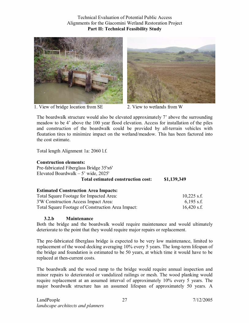
3.2 Trail Alignment 1a –Sir Francis Drake Boulevard to Lagunitas Creek This alignment would maintain one of the existing informal public access alignments within the Project Area. For many years, the public has accessed the Giacomini property along two unofficial trails. Trail Alignment 1a is along the top of the levee at the northern end of the West Pasture (see Figure 4). It can be accessed from a small parking area on the east shoulder of Sir Francis Drake Boulevard north of Drake’s View Drive. A bridge crossing Fish Hatchery Creek at the west end of this section might be required under Restoration Alternative C, as well as a boardwalk, as the north levee would potentially be removed.
3.2.a Construction This trail would extend from the existing pullout at Sir Francis Drake Boulevard, across a pedestrian bridge over Fish Hatchery Creek, assuming Restoration Alternatives B - D are implemented, and on a boardwalk to Lagunitas Creek and for a distance south along the west creek bank. The potential bridge would span a channel approximately 25’ wide (see Photo 1). The actual span of the bridge is estimated at 35’ to allow setback from the creek banks. The most cost-effective approach for the construction of this bridge would be to use a pre-fabricated fiberglass bridge on a concrete pier foundation (see Figure 5). The bridge would be elevated approximately 7’ above the adjacent meadow, and approximately 4’ above the 100 year flood elevation, to avoid blocking flood waters that overflow the creek banks during storm events Assuming the existing levee is removed to restore the original hydrology, a short wood ramp would lead from the slope at the edge of the turnout at Sir Francis Drake Boulevard, approximately at the existing gate, to the west end of the bridge. The boardwalk would start at the east end of the bridge, extending over the wetlands shown in Photo 2. Because this boardwalk and bridge would not offer a through connection, they are assumed to be for pedestrian use only, and are assumed to be 5 feet wide rather than the 8 to 10 feet required for a multi-use bicycle/pedestrian boardwalk. The boardwalk (see Figure 6) would be pressure-treated wood on pressure-treated wood pilings. It would have wood frame railings with coated welded wire mesh to provide protection from falling with minimum visual impact and maximum visibility for anyone too short to see over the railing. To minimize direct impact on the wetlands, and to avoid interference with flood flows or trapping of flood-borne debris, the boardwalk would be designed with a maximum practical span of approximately 12’ to 16’ feet between pilings to limit the number of pilings. For structural reasons, the span may have to be reduced to as little in 10’ at some locations such as bends in the boardwalk.
Technical Evaluation of Potential Public Access Alignments for the Giacomini Wetland Restoration Project
Part II: Technical Feasibility Study
LandPeople 27 7/12/2005 landscape architects and planners
The boardwalk structure would also be elevated approximately 7’ above the surrounding meadow to be 4’ above the 100 year flood elevation. Access for installation of the piles and construction of the boardwalk could be provided by all-terrain vehicles with floatation tires to minimize impact on the wetland/meadow. This has been factored into the cost estimate. Total length Alignment 1a: 2060 l.f. Construction elements: Pre-fabricated Fiberglass Bridge 35'x6' Elevated Boardwalk – 5’ wide, 2025'
Total estimated construction cost: $1,139,349 Estimated Construction Area Impacts: Total Square Footage for Impacted Area: 10,225 s.f.3'W Construction Access Impact Area: 6,195 s.f.Total Square Footage of Construction Area Impact: 16,420 s.f.
3.2.b Maintenance Both the bridge and the boardwalk would require maintenance and would ultimately deteriorate to the point that they would require major repairs or replacement. The pre-fabricated fiberglass bridge is expected to be very low maintenance, limited to replacement of the wood decking averaging 10% every 5 years. The long-term lifespan of the bridge and foundation is estimated to be 50 years, at which time it would have to be replaced at then-current costs. The boardwalk and the wood ramp to the bridge would require annual inspection and minor repairs to deteriorated or vandalized railings or mesh. The wood planking would require replacement at an assumed interval of approximately 10% every 5 years. The major boardwalk structure has an assumed lifespan of approximately 50 years. A
1. View of bridge location from SE 2. View to wetlands from W
Technical Evaluation of Potential Public Access Alignments for the Giacomini Wetland Restoration Project
Part II: Technical Feasibility Study
LandPeople 28 7/12/2005 landscape architects and planners
catastrophic event such as a major flood could damage or destroy the boardwalk or bridge during any storm season due to their location in the flood plain. Fire is another potential event that could require replacement or significant reconstruction of the boardwalk structure. Total estimated annual maintenance/replacement cost for Alignment 1a is $22,371.
3.2.c Land Use Impacts Construction of the bridge and boardwalk could have potential short-term noise impacts, on nearby residences (there are no adjacent residences), as could maintenance and repair activities.
Technical Evaluation of Potential Public Access Alignments for the Giacomini Wetland Restoration Project
Part II: Technical Feasibility Study
LandPeople 32 7/12/2005 landscape architects and planners
3.3 TRAIL ALIGNMENT 2C – HISTORIC RAILROAD GRADE A trail would be constructed on the historic railroad grade that exists along the eastern bank of Tomasini Creek (see Figure 7). The southern terminus of the railroad grade trail would connect to Mesa Road in Point Reyes Station. The northern reach of the railroad grade trail would connect to the existing Tomales Bay Trail, an unpaved multi-use trail that extends from just north of the Tomasini Creek outlet to Tomales Bay northeast to Highway 1. Important considerations for design of this alignment are noted in the Phase I Study:
A large section of the Point Reyes Mesa supports seeps and springs whose waters flow down the Mesa and across the historic railroad grade into Tomasini Creek. The Giacominis actually maintained the historic railroad grade for some period after it was abandoned by the railroad, but stopped more than 10 years ago, because the amount of seep/spring flow required installation of a number of culverts and constant road maintenance (Richard and Robert Giacomini, pers.comm.). To ensure that erosion and sediment loading into the creek is not exacerbated by creation of a trail, the section through this area might need to be constructed as a boardwalk. However, this boardwalk would probably require maintenance to remove debris and sediment from high flows in Tomasini Creek that would spill onto these narrow floodplains during storm events.4
3.3.a Construction
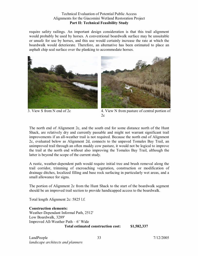
This alignment is currently passable at the north and south ends, but gets increasingly wet toward the central portion, where it quickly becomes impassable due to dense riparian vegetation that has grown over the railroad grade, including large trees. This trail alignment would be part of a loop that would be open to multi-use, and thus is recommended to be constructed with an 8’ width to accommodate shared use by horses and pedestrians, and potentially bicyclists (assuming a relatively low use volume). A boardwalk is anticipated to be the most practical form for a trail in the wet, central portion of Alignment 2c due to the large amount of water seeping from the hillside (see Figure 8). Allowing this water to flow more or less continuously under the boardwalk would avoid need for the drainage ditches and culverts that caused the Giacominis to give up on maintaining the route. A boardwalk constructed on Alignment 2c would not need to be designed to avoid interference with flood waters. Although it is within the effective flood channel of Tomasini Creek during 50 to 100 year storms, the boardwalk would be designed to be inundated and is in a location and at a level that would not significantly block flows. It would be constructed of pressure-treated wood supported on concrete pier footings, rather than the pilings required for the Alignment 1a boardwalk, and could have shortened, more economical spans between footings. This boardwalk could potentially be constructed at a relatively low elevation (e.g. 12 to 18” above grade) and thus would not
4 Kamman Hydrology & Engineering, Inc., LSA Associates, Inc., and Point Reyes National Seashore. 2004. Technical Evaluation of Potential Public Access Alignments for the Giacomini Wetland Restoration Project. Part I: Resources Study, P. 22. Prepared for Point Reyes National Seashore.
Technical Evaluation of Potential Public Access Alignments for the Giacomini Wetland Restoration Project
Part II: Technical Feasibility Study
LandPeople 33 7/12/2005 landscape architects and planners
require safety railings. An important design consideration is that this trail alignment would probably be used by horses. A conventional boardwalk surface may be unsuitable or unsafe for use by horses, and this use would certainly increase the rate at which the boardwalk would deteriorate. Therefore, an alternative has been estimated to place an asphalt chip seal surface over the planking to accommodate horses.
The north end of Alignment 2c, and the south end for some distance north of the Hunt Shack, are relatively dry and currently passable and might not warrant significant trail improvements if an all-weather trail is not required. Because the north end of Alignment 2c, evaluated below as Alignment 2d, connects to the unpaved Tomales Bay Trail, an unimproved trail through an often muddy cow pasture, it would not be logical to improve the trail at the north end without also improving the Tomales Bay Trail, although the latter is beyond the scope of the current study. A rustic, weather-dependent path would require initial tree and brush removal along the trail corridor, trimming of encroaching vegetation, construction or modification of drainage ditches, localized filling and base rock surfacing in particularly wet areas, and a small allowance for signs. The portion of Alignment 2c from the Hunt Shack to the start of the boardwalk segment should be an improved trail section to provide handicapped access to the boardwalk. Total length Alignment 2c: 5825 l.f. Construction elements: Weather-Dependant Informal Path, 2512' Low Boardwalk, 3289' Improved All-Weather Path – 6’ Wide
Total estimated construction cost: $1,582,337
3. View S from N end of 2c 4. View N from pasture of central portion of 2c
Technical Evaluation of Potential Public Access Alignments for the Giacomini Wetland Restoration Project
Part II: Technical Feasibility Study
LandPeople 34 7/12/2005 landscape architects and planners
Estimated Construction Area Impacts: Total Square Footage for Impacted Area: 55,630 s.f.3'W Construction Access Impact Area: 18,906 s.f.Total Square Footage of Construction Area Impact: 76,867 s.f.
3.3.b Maintenance As observed during site reconnaissance, and experienced long-term by the Giacominis, this alignment is in a wet location and will require high maintenance. The use of horses on the boardwalk would also accelerate the need for maintenance. Annual inspection and maintenance would include trimming of encroaching vegetation and removal of leaf litter from nearby trees on and adjacent to the boardwalk. This boardwalk trail section will require more frequent replacement of damaged or deteriorated planks, assumed to be 20% every 5 years, along with renewal of the asphalt chip seal surface. Due to the wetter conditions, this boardwalk is assumed to have a lifespan of approximately 30 years before the main structural components would need to be replaced. The weather-dependant informal path portion of the alignment would require much less maintenance. Annual trimming of encroaching vegetation would be required. After major storm events and at least annually the drainage ditches associated with the trail would require cleanout, and the trail surface may need localized restoration. The improved path section would require similar maintenance to the weather-dependant trail section. If the trail is surfaced with A.C. the lifespan before it would need to be resurfaced is assumed to be 10 years. If the path is surfaced with D.G. with a pine resin binder, the harder surface is estimated to last approximately 20 years before it needs to be resurfaced. Total estimated annual maintenance cost for Alignment 2c is $40,687.
3.3.c Land Use Impacts Construction of the trail, especially the boardwalk portion, could have potential short-term noise impacts, as could maintenance and repair activities. Residents in the vicinity of this trail alignment have expressed concerns about noise generated by trail users, and about the trail’s impact on the wetlands and general wildlife habitat. They have also expressed concern about increased parking on Mesa Road to access the trail. The use of horses on the boardwalk portion could be an added generator of noise compared to a natural or gravel-surfaced path. This noise would be at least partially addressed by use of a chip seal surface over the boardwalk.
Technical Evaluation of Potential Public Access Alignments for the Giacomini Wetland Restoration Project
Part II: Technical Feasibility Study
LandPeople 37 7/12/2005 landscape architects and planners
3.4 TRAIL ALIGNMENT 2D – HISTORIC RAILROAD GRADE, MESA ROAD TO GIACOMINI
HUNT SHACK This alignment would represent a spur access version of Trail Alignment 2c, incorporating only the portion of the historic railroad grade between Mesa Road and the Giacomini Hunt Shack. This alignment was developed based on input received during internal scoping.
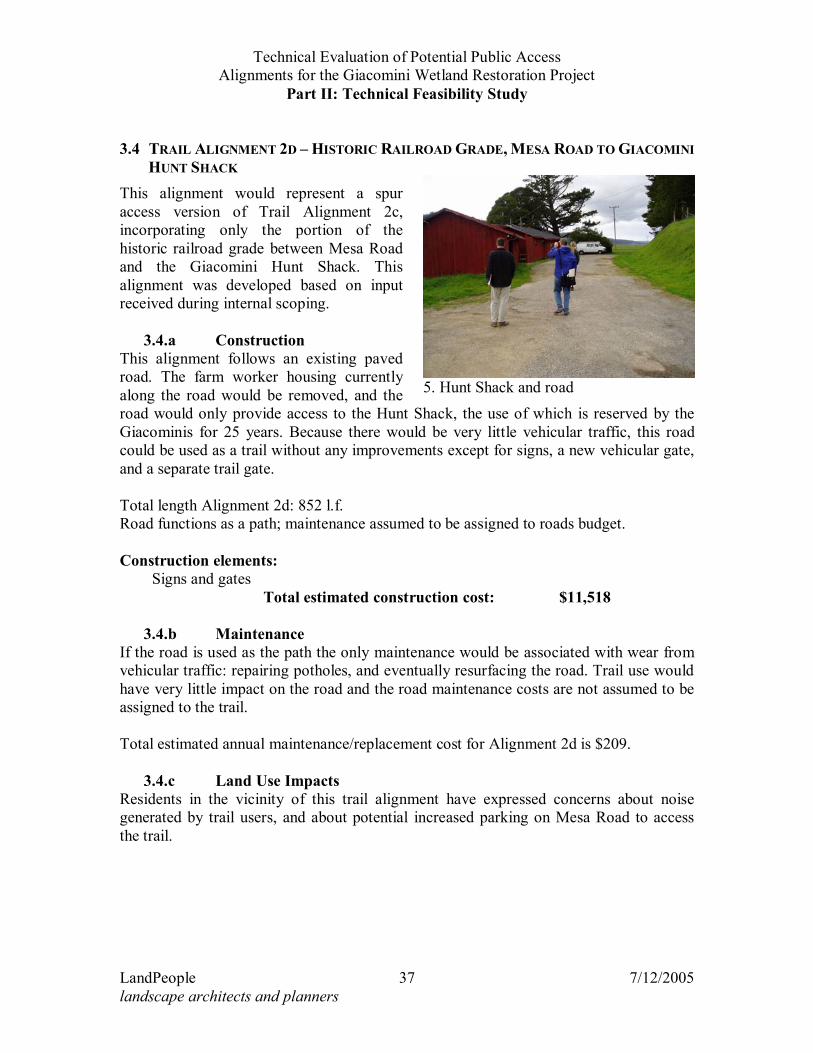
3.4.a Construction This alignment follows an existing paved road. The farm worker housing currently along the road would be removed, and the road would only provide access to the Hunt Shack, the use of which is reserved by the Giacominis for 25 years. Because there would be very little vehicular traffic, this road could be used as a trail without any improvements except for signs, a new vehicular gate, and a separate trail gate. Total length Alignment 2d: 852 l.f. Road functions as a path; maintenance assumed to be assigned to roads budget. Construction elements: Signs and gates
Total estimated construction cost: $11,518
3.4.b Maintenance If the road is used as the path the only maintenance would be associated with wear from vehicular traffic: repairing potholes, and eventually resurfacing the road. Trail use would have very little impact on the road and the road maintenance costs are not assumed to be assigned to the trail. Total estimated annual maintenance/replacement cost for Alignment 2d is $209.
3.4.c Land Use Impacts Residents in the vicinity of this trail alignment have expressed concerns about noise generated by trail users, and about potential increased parking on Mesa Road to access the trail.
5. Hunt Shack and road
Technical Evaluation of Potential Public Access Alignments for the Giacomini Wetland Restoration Project
Part II: Technical Feasibility Study
LandPeople 38 7/12/2005 landscape architects and planners
3.5 TRAIL ALIGNMENT 2E – HISTORIC RAILROAD GRADE, SPUR TRAIL FROM TOMALES BAY TRAIL
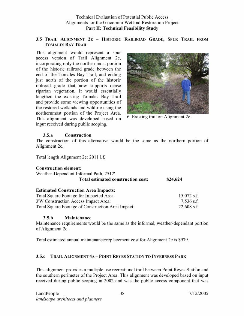
This alignment would represent a spur access version of Trail Alignment 2c, incorporating only the northernmost portion of the historic railroad grade between the end of the Tomales Bay Trail, and ending just north of the portion of the historic railroad grade that now supports dense riparian vegetation. It would essentially lengthen the existing Tomales Bay Trail and provide some viewing opportunities of the restored wetlands and wildlife using the northernmost portion of the Project Area. This alignment was developed based on input received during public scoping.
3.5.a Construction The construction of this alternative would be the same as the northern portion of Alignment 2c. Total length Alignment 2e: 2011 l.f. Construction element: Weather-Dependant Informal Path, 2512'
Total estimated construction cost: $24,624 Estimated Construction Area Impacts: Total Square Footage for Impacted Area: 15,072 s.f.3'W Construction Access Impact Area: 7,536 s.f.Total Square Footage of Construction Area Impact: 22,608 s.f.
3.5.b Maintenance Maintenance requirements would be the same as the informal, weather-dependant portion of Alignment 2c. Total estimated annual maintenance/replacement cost for Alignment 2e is $979. 3.5.c TRAIL ALIGNMENT 4A – POINT REYES STATION TO INVERNESS PARK This alignment provides a multiple use recreational trail between Point Reyes Station and the southern perimeter of the Project Area. This alignment was developed based on input received during public scoping in 2002 and was the public access component that was
6. Existing trail on Alignment 2e
Technical Evaluation of Potential Public Access Alignments for the Giacomini Wetland Restoration Project
Part II: Technical Feasibility Study
LandPeople 39 7/12/2005 landscape architects and planners
incorporated into the preliminary restoration concepts introduced to the public during scoping in 2004. It incorporates several sub-alignments that are evaluated separately in this section. If combined, all of these sub-alignments represent a trail between Point Reyes Station and Inverness Park. Some of the sub-alignments include potential Viewing Platforms, including Location #3 near the Giacomini Dairy and Elevated Overlook Location #2 at the White House Pool County Park. Completion of the entire alignment 4a would require construction of a bridge across Lagunitas Creek at the former site of the Giacomini Ranch seasonal gravel dam.
3.5.d Construction
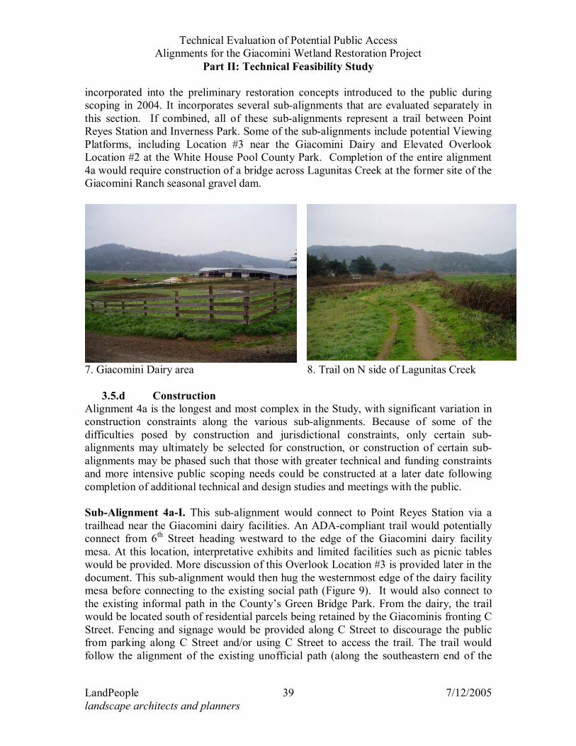
Alignment 4a is the longest and most complex in the Study, with significant variation in construction constraints along the various sub-alignments. Because of some of the difficulties posed by construction and jurisdictional constraints, only certain sub-alignments may ultimately be selected for construction, or construction of certain sub-alignments may be phased such that those with greater technical and funding constraints and more intensive public scoping needs could be constructed at a later date following completion of additional technical and design studies and meetings with the public. Sub-Alignment 4a-I. This sub-alignment would connect to Point Reyes Station via a trailhead near the Giacomini dairy facilities. An ADA-compliant trail would potentially connect from 6th Street heading westward to the edge of the Giacomini dairy facility mesa. At this location, interpretative exhibits and limited facilities such as picnic tables would be provided. More discussion of this Overlook Location #3 is provided later in the document. This sub-alignment would then hug the westernmost edge of the dairy facility mesa before connecting to the existing social path (Figure 9). It would also connect to the existing informal path in the County’s Green Bridge Park. From the dairy, the trail would be located south of residential parcels being retained by the Giacominis fronting C Street. Fencing and signage would be provided along C Street to discourage the public from parking along C Street and/or using C Street to access the trail. The trail would follow the alignment of the existing unofficial path (along the southeastern end of the
7. Giacomini Dairy area 8. Trail on N side of Lagunitas Creek
Technical Evaluation of Potential Public Access Alignments for the Giacomini Wetland Restoration Project
Part II: Technical Feasibility Study
LandPeople 40 7/12/2005 landscape architects and planners
East Pasture) to the location of the former gravel dam location. The levee along this part of the trail route is to be lowered as part of the Wetland Restoration Project, and this section of trail will be subject to inundation during major flood conditions, thereby making access weather-dependent. These paths would be relatively straightforward to construct with a base rock/decomposed granite trail section. Total length Sub-Alignment 4a-I: 2423 l.f.
Total estimated gross construction cost: $256,067 Estimated Construction Area Impacts:
All
Options Total Square Footage for Impacted Area: 14,568 s.f.3'W Construction Access Impact Area: 7,359 s.f.Total Square Footage of Construction Area Impact:
21,927 s.f.
Total Square Footage of Construction Area Impact w/ Optional Guardrail: N/A
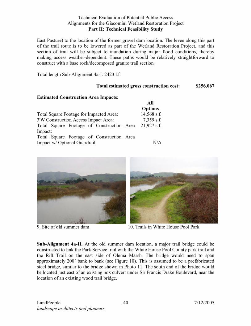
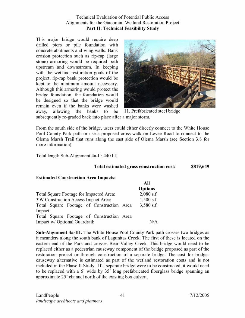
Sub-Alignment 4a-II. At the old summer dam location, a major trail bridge could be constructed to link the Park Service trail with the White House Pool County park trail and the Rift Trail on the east side of Olema Marsh. The bridge would need to span approximately 200’ bank to bank (see Figure 10). This is assumed to be a prefabricated steel bridge, similar to the bridge shown in Photo 11. The south end of the bridge would be located just east of an existing box culvert under Sir Francis Drake Boulevard, near the location of an existing wood trail bridge.
9. Site of old summer dam 10. Trails in White House Pool Park
Technical Evaluation of Potential Public Access Alignments for the Giacomini Wetland Restoration Project
Part II: Technical Feasibility Study
LandPeople 41 7/12/2005 landscape architects and planners
This major bridge would require deep drilled piers or pile foundation with concrete abutments and wing walls. Bank erosion protection such as rip-rap (large stone) armoring would be required both upstream and downstream. In keeping with the wetland restoration goals of the project, rip-rap bank protection would be kept to the minimum amount necessary. Although this armoring would protect the bridge foundation, the foundation would be designed so that the bridge would remain even if the banks were washed away, allowing the banks to be subsequently re-graded back into place after a major storm. From the south side of the bridge, users could either directly connect to the White House Pool County Park path or use a proposed cross-walk on Levee Road to connect to the Olema Marsh Trail that runs along the east side of Olema Marsh (see Section 3.8 for more information). Total length Sub-Alignment 4a-II: 440 l.f.
Total estimated gross construction cost: $819,649
Estimated Construction Area Impacts:
All
Options Total Square Footage for Impacted Area: 2,080 s.f.3'W Construction Access Impact Area: 1,500 s.f.Total Square Footage of Construction Area Impact:
3,580 s.f.
Total Square Footage of Construction Area Impact w/ Optional Guardrail: N/A
Sub-Alignment 4a-III. The White House Pool County Park path crosses two bridges as it meanders along the south bank of Lagunitas Creek. The first of these is located on the eastern end of the Park and crosses Bear Valley Creek. This bridge would need to be replaced either as a pedestrian causeway component of the bridge proposed as part of the restoration project or through construction of a separate bridge. The cost for bridge-causeway alternative is estimated as part of the wetland restoration costs and is not included in the Phase II Study. If a separate bridge were to be constructed, it would need to be replaced with a 6’ wide by 35’ long prefabricated fiberglass bridge spanning an approximate 25’ channel north of the existing box culvert.
11. Prefabricated steel bridge
Technical Evaluation of Potential Public Access Alignments for the Giacomini Wetland Restoration Project
Part II: Technical Feasibility Study
LandPeople 42 7/12/2005 landscape architects and planners
To the west, this sub-alignment would follow existing informal, decomposed granite-surfaced trails in the White House Pool area, which is leased from the state of California’s Wildlife Conservation Board by the County of Marin Parks and Open Space District (County Parks). This sub-alignment would be developed with full approval and cooperation of the landowners, the state’s Wildlife Conservation Board, and County Parks. This sub-alignment could be improved with base rock and decomposed granite to a full 6’ width, or if preferred, or it could receive little or no improvements. Just north of the existing parking area for the Park, a wooden trail bridge approximately 50’ long crosses the historic channel of Bear Valley Creek (see Figure 11). There is no scenario under the Wetland Restoration Plan to widen this channel. It is recommended that this bridge be replaced with a prefabricated fiberglass trail bridge, also 50’ long. From the White House Pool County parking lot, an ADA-compliant path would lead to Elevated Overlook #2, which would also be ADA-compliant and enable visitors to view the restored wetlands. The sub-alignment would continue west through the park to connect with Sir Francis Drake Boulevard. Total length Sub-Alignment 4a-III: 1993 l.f.
Total estimated gross construction cost: $333,466 Estimated Construction Area Impacts:
All
Options Total Square Footage for Impacted Area: 400 s.f.3'W Construction Access Impact Area: 150 s.f.Total Square Footage of Construction Area Impact:
550 s.f.
Total Square Footage of Construction Area Impact w/ Optional Guardrail:
Technical Evaluation of Potential Public Access Alignments for the Giacomini Wetland Restoration Project
Part II: Technical Feasibility Study
LandPeople 45 7/12/2005 landscape architects and planners
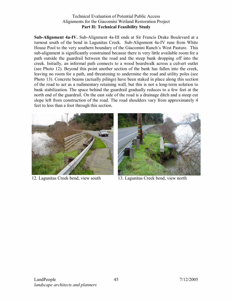
Sub-Alignment 4a-IV. Sub-Alignment 4a-III ends at Sir Francis Drake Boulevard at a turnout south of the bend in Lagunitas Creek. Sub-Alignment 4a-IV runs from White House Pool to the very southern boundary of the Giacomini Ranch’s West Pasture. This sub-alignment is significantly constrained because there is very little available room for a path outside the guardrail between the road and the steep bank dropping off into the creek. Initially, an informal path connects to a wood boardwalk across a culvert outlet (see Photo 12). Beyond this point another section of the bank has fallen into the creek, leaving no room for a path, and threatening to undermine the road and utility poles (see Photo 13). Concrete beams (actually pilings) have been staked in place along this section of the road to act as a rudimentary retaining wall, but this is not a long-term solution to bank stabilization. The space behind the guardrail gradually reduces to a few feet at the north end of the guardrail. On the east side of the road is a drainage ditch and a steep cut slope left from construction of the road. The road shoulders vary from approximately 4 feet to less than a foot through this section.
12. Lagunitas Creek bend, view south 13. Lagunitas Creek bend, view north
Technical Evaluation of Potential Public Access Alignments for the Giacomini Wetland Restoration Project
Part II: Technical Feasibility Study
LandPeople 47 7/12/2005 landscape architects and planners
Long-term protection of the road and utility poles from creek bank failure will require a major bank protection project to be undertaken at some point. In conjunction with the bank protection project, the road bench could be widened to provide room for a separate path and Class II bike lanes. Because this is a steep narrow bank adjacent to a deep pool at the outside of a sharp bend in the creek, the bank protection will need to be carefully designed. To maintain the current channel width, sheet pilings might have to be used, rather than some less expensive solution, such as rip-rap. Another alternative might be to realign the road to the east by building a retaining wall along the steep embankment north of Balboa Avenue. Then the current failing creek bank could be replaced by rip-rap slope protection. In any case, this is a major design and construction project that will involve multiple agencies and issues. It is far beyond the scope of this study to address these design issues, and beyond the scope of a local trail improvement project to implement such improvements. Presumably the County of Marin would take the lead with the National Park Service as a participant in planning such a project to help minimize impact on resources and plan for the best trail arrangement. Until such time as a major creek bank protection/road realignment project occurs, the only option for providing a trail though this section is to create a cantilevered boardwalk through this segment, similar to that described under Condition F (see Design Assumptions section earlier in this document for a description of the various Conditions). Including this section at the bend in Lagunitas Creek, and areas to the north, the space adjacent to the roadside available for a trail ranges from wide and flat at various turnouts to no available space except for steep slopes and areas with potential wetlands and riparian vegetation. These variable conditions have been characterized in typical cross-sections Conditions A through F (see Figure 3), A representing the least constrained condition, and F representing the most constrained. Turnouts (T) are broken down into other Conditions based on a standardized set of assumptions, as detailed in Section 3.1. These conditions have been color-coded on the maps – Figures 8, 10 and 13. Total length Sub-Alignment 4a-IV: 1229 l.f.
Total estimated construction cost w/fill slopes (Option 1): $392,229Total estimated construction cost w/fill slopes and guardrail: $435,981
Total estimated construction cost w/retaining wall (Option 2): $486,496Total estimated construction cost w/retaining wall & guardrail: $595,946
Total estimated construction cost w/boardwalk (Option 3): $568,688Total estimated construction cost w/boardwalk & guardrail: $608,211
Estimated Construction Area Impacts: Option 1 Option 2 Option 3 Total Square Footage for Impacted Area: 7,588 s.f. 4,160 s.f. 3,900 s.f.3'W Construction Access Impact Area: 3,687 s.f. 3,687 s.f. 3,687 s.f.Total Square Footage of Construction Area Impact:
11,275 s.f. 7,847 s.f. 7,587 s.f.
Total Square Footage of Construction Area 12,313 s.f. 8,885 s.f. 8,625 s.f.
Technical Evaluation of Potential Public Access Alignments for the Giacomini Wetland Restoration Project
Part II: Technical Feasibility Study
LandPeople 48 7/12/2005 landscape architects and planners
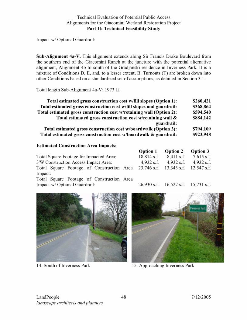
Impact w/ Optional Guardrail: Sub-Alignment 4a-V. This alignment extends along Sir Francis Drake Boulevard from the southern end of the Giacomini Ranch at the juncture with the potential alternative alignment, Alignment 4b to south of the Gradjanski residence in Inverness Park. It is a mixture of Conditions D, E, and, to a lesser extent, B. Turnouts (T) are broken down into other Conditions based on a standardized set of assumptions, as detailed in Section 3.1. Total length Sub-Alignment 4a-V: 1973 l.f.
Total estimated gross construction cost w/fill slopes (Option 1): $260,421Total estimated gross construction cost w/fill slopes and guardrail: $368,864
Total estimated gross construction cost w/retaining wall (Option 2): $594,540Total estimated gross construction cost w/retaining wall &
guardrail: $884,142
Total estimated gross construction cost w/boardwalk (Option 3): $794,109Total estimated gross construction cost w/boardwalk & guardrail: $923,948
Estimated Construction Area Impacts: Option 1 Option 2 Option 3 Total Square Footage for Impacted Area: 18,814 s.f. 8,411 s.f. 7,615 s.f.3'W Construction Access Impact Area: 4,932 s.f. 4,932 s.f. 4,932 s.f.Total Square Footage of Construction Area Impact:
23,746 s.f. 13,343 s.f. 12,547 s.f.
Total Square Footage of Construction Area Impact w/ Optional Guardrail: 26,930 s.f. 16,527 s.f. 15,731 s.f.
14. South of Inverness Park 15. Approaching Inverness Park
Technical Evaluation of Potential Public Access Alignments for the Giacomini Wetland Restoration Project
Part II: Technical Feasibility Study
LandPeople 49 7/12/2005 landscape architects and planners
Summary, Alignment 4a. If combined, all of the Sub-Alignments I-V and would extend from the eastern to the western perimeters of the Project Area. Total length Alignment 4a: 8058 l.f. Construction elements: Improved All-Weather Path – 6’ Wide, D.G./Pine Resin Binder Surface, 5349' (Condition A, B, C)
Concrete Retaining Walls w/48” Vinyl Coated Chain Link Fence, 1928' (Condition C, D, and E assuming retaining wall option)
Improved All-Weather Path – 6’ Wide, D.G./Pine Resin Binder Surface, 1906' (Condition D, E assuming retaining wall option)
Cantilevered Boardwalk – 6’ wide (1489' Condition D assuming boardwalk option - delete path item above)
Cantilevered Boardwalk – 8’ wide, 417' (Condition E assuming boardwalk option - delete path item above)
Cantilevered Boardwalk – 8’ wide (486' Condition F boardwalk) Pre-Fabricated Steel Bridge 200' long Pre-fabricated Fiberglass Bridge 35'x6' Pre-fabricated Fiberglass Bridge 50'x6'
Total estimated construction cost w/fill slopes (Option 1): $2,061,832Total estimated construction cost w/fill slopes and guardrail: $2,214,027
Total estimated construction cost w/retaining wall (Option 2): $2,490,218Total estimated construction cost w/retaining wall & guardrail: $2,889,270
Total estimated construction cost w/boardwalk (Option 3): $2,771,979Total estimated construction cost w/boardwalk & guardrail: $2,941,341
Estimated Construction Area Impacts: Option 1 Option 2 Option 3 Total Square Footage for Impacted Area: 43,450 s.f. 29,619 s.f. 28,563 s.f.3'W Construction Access Impact Area: 17,628 s.f. 17,628 s.f. 17,628 s.f.Total Square Footage of Construction Area Impact:
61,078 s.f. 47,247 s.f. 46,191 s.f.
Total Square Footage of Construction Area Impact w/ Optional Guardrail: 39,243 s.f. 25,412 s.f. 24,356 s.f.
3.5.e Maintenance The maintenance considerations for the base rock/decomposed granite portions of Alignment 4a and its sub-alignments include annual trimming of vegetation along the trail edge, cleanout of culverts (if any) and clearing of litter and debris from the trail surface. Over a lifespan estimated at 10 years, the trail would need to be resurfaced, but on the portion used by horses this period is reduced to 5 years. Following major storm/flood events, the trail base and surface material may need to be replaced in specific locations.
Technical Evaluation of Potential Public Access Alignments for the Giacomini Wetland Restoration Project
Part II: Technical Feasibility Study
LandPeople 50 7/12/2005 landscape architects and planners
The concrete retaining walls would require no maintenance over the long term, but could eventually fail due to earth movement or settlement, or erosion. The chain link fence/railing associated with the retaining walls would require occasional replacement of damaged fence fabric and posts, and eventual replacement, similar to the components of the boardwalk. Maintenance requirements and cost for the cantilevered boardwalk sections are likely to be similar to the requirements for boardwalks in the floodplain, such as Alignment 1a and 4b. The boardwalk in Condition F and Sub-Alignment 4a-IV would have to be founded on some creek bank areas that are clearly unstable and are gradually failing. There is a strong potential that portions of the creek bank supporting the boardwalk in the Condition F portion could eventually fail, necessitating a localized bank reconstruction project and replacement of a portion of the boardwalk. Requirements for maintenance of prefabricated bridges are as described under Alignment 1a. Total estimated annual maintenance/replacement cost for Alignment 4a with Option 1, fill slopes is $45,857; for Option 2, retaining walls $51,444, and for Option 3, boardwalks, the estimate is $58,758.
3.5.f Land Use Impacts Construction of the trail improvements and bridges could have short-term noise and dust impacts on neighboring properties, as could major repair or reconstruction projects. Potential land use impacts associated with use of Alignment 4a or Sub-Alignments 4a-I and 4a-II would primarily occur at the east end, at Point Reyes Station. Especially during the summer and on weekends parking in town is at a premium. Currently, residents in the area of 3rd and C Streets report visitors parking to access the area of the proposed trail for dog walking and blackberry picking. Formalizing and improving the trail, and associating it with a more extensive trail system, is likely to enlarge this parking and access. Measures that would help to reduce this impact include providing an official trailhead at the former dairy facility, with access via 6th Street, providing fencing and signage along C Street to discourage parking for trail access. Fencing could be installed to prevent access to the trail from C Street, but this would also exclude local residents. Another potential land use impact/conflict of Alignment 4a at Sub-Alignments 4a-I and 4a-II would be on the homes on the south side of Lagunitas Creek (fronting along the north side of Levee Road). Increased use of the current informal trail would have some impact on their privacy, and could cause increased noise, and generally alter the current rural character. At the west end of the trail, at the south end of Inverness Park there could be similar impacts of increased public use along the frontage. Though not technically a land use impact, the trail could change the visual character of the area by adding fill, walls and/or boardwalks, and constructing the major bridge at the summer dam location. Adding guardrail safety barriers could also be a significant change.
Technical Evaluation of Potential Public Access Alignments for the Giacomini Wetland Restoration Project
Part II: Technical Feasibility Study
LandPeople 51 7/12/2005 landscape architects and planners
3.6 TRAIL ALIGNMENT 4B – BOARDWALK BYPASS SOUTH OF INVERNESS PARK This is an alternative to the portion of Alignment 4a between the bend in the creek north of White House Pool and Inverness Park. It would be created by constructing an elevated boardwalk through the West Pasture to Sir Francis Drake Boulevard just south of the Gradjanski property.
3.6.a Construction This boardwalk would have similar construction to the boardwalk described for Alignment 2c. It is recommended to be 8’ wide because it would be accommodating through bicycle and pedestrian traffic along a main trail route. The boardwalk would be slightly elevated above the adjacent wetland meadow to allow surface water to normally flow below the structure and to keep the structure dry as possible. However the structure would be below the flood elevation during major storms and so is conceived as a weather dependant trail. Total length Alignment 4b: 2243 l.f. Construction element: Boardwalk – 8’ wide, 2243' long
Total estimated construction cost: $998,251 Estimated Construction Area Impacts: Total Square Footage for Impacted Area: 17,944 s.f.3'W Construction Access Impact Area: 6,729 s.f.Total Square Footage of Construction Area Impact: 24,673 s.f.
3.6.b Maintenance This boardwalk would have similar maintenance requirements to the boardwalk described under Alignment 2c, with a proportional increase due to the greater width. Total estimated annual maintenance/replacement cost for Alignment 4b is $26,095.
3.6.c Land Use Impacts This alignment would have similar impacts to residents at the south end of Inverness Park as those described under Alignment 4a. 3.7 TRAIL ALIGNMENT 4C – SOUTH INVERNESS PARK TO DRAKES VIEW DRIVE This alignment would extend the multiple use path from the Gradjanski property at the south end of Inverness Park along the shoulder of Sir Francis Drake Boulevard to just north of Drakes View Drive (see Figure 12). It was developed based on input received
Technical Evaluation of Potential Public Access Alignments for the Giacomini Wetland Restoration Project
Part II: Technical Feasibility Study
LandPeople 52 7/12/2005 landscape architects and planners
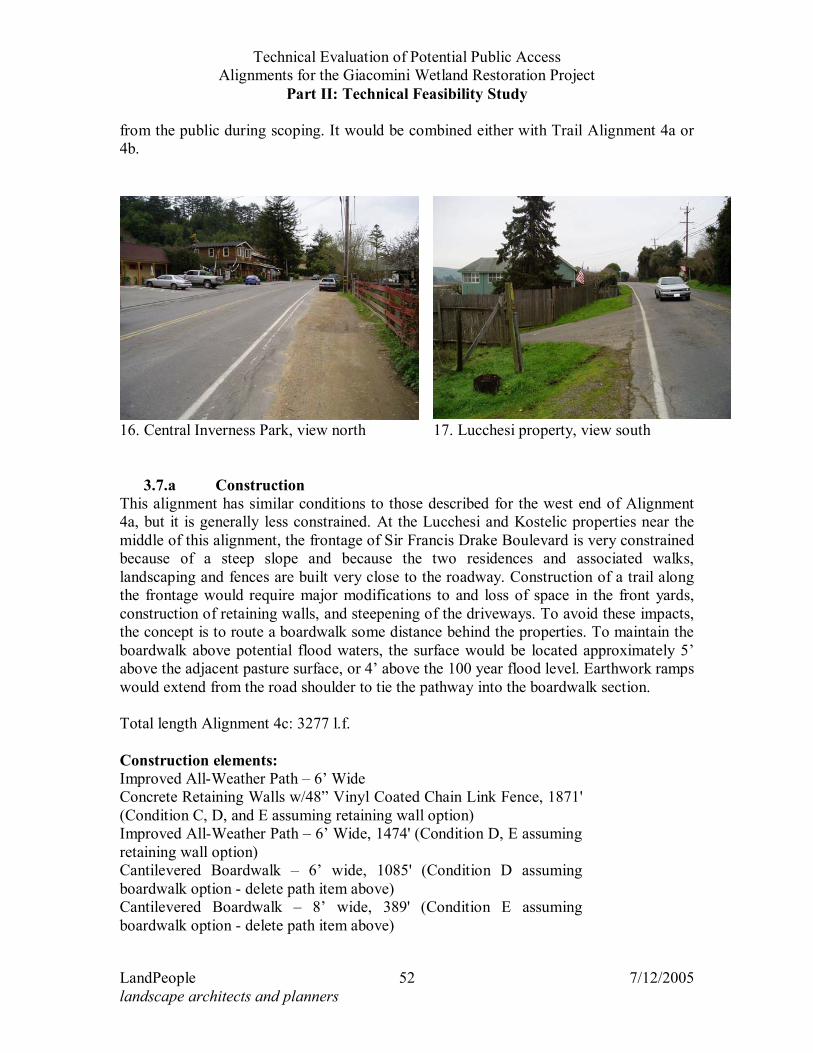
from the public during scoping. It would be combined either with Trail Alignment 4a or 4b.
3.7.a Construction This alignment has similar conditions to those described for the west end of Alignment 4a, but it is generally less constrained. At the Lucchesi and Kostelic properties near the middle of this alignment, the frontage of Sir Francis Drake Boulevard is very constrained because of a steep slope and because the two residences and associated walks, landscaping and fences are built very close to the roadway. Construction of a trail along the frontage would require major modifications to and loss of space in the front yards, construction of retaining walls, and steepening of the driveways. To avoid these impacts, the concept is to route a boardwalk some distance behind the properties. To maintain the boardwalk above potential flood waters, the surface would be located approximately 5’ above the adjacent pasture surface, or 4’ above the 100 year flood level. Earthwork ramps would extend from the road shoulder to tie the pathway into the boardwalk section. Total length Alignment 4c: 3277 l.f. Construction elements: Improved All-Weather Path – 6’ Wide Concrete Retaining Walls w/48” Vinyl Coated Chain Link Fence, 1871' (Condition C, D, and E assuming retaining wall option)
Improved All-Weather Path – 6’ Wide, 1474' (Condition D, E assuming retaining wall option)
Cantilevered Boardwalk – 6’ wide, 1085' (Condition D assuming boardwalk option - delete path item above)
Cantilevered Boardwalk – 8’ wide, 389' (Condition E assuming boardwalk option - delete path item above)
16. Central Inverness Park, view north 17. Lucchesi property, view south
Technical Evaluation of Potential Public Access Alignments for the Giacomini Wetland Restoration Project
Part II: Technical Feasibility Study
LandPeople 53 7/12/2005 landscape architects and planners
Elevated Boardwalk – 8’ wide, 618' (behind Lucchesi and Kostelic properties)
Total estimated construction cost w/fill slopes (Option 1): $690,816Total estimated construction cost w/fill slopes & guardrail: $836,988
Total estimated construction cost w/retaining wall (Option 2): $1,052,028Total estimated construction cost w/retaining wall & guardrail: $1,380,203
Total estimated construction cost w/boardwalk (Option 3): $1,239,131Total estimated construction cost w/boardwalk & guardrail: $1,416,962
Estimated Construction Area Impacts: Option 1 Option 2 Option 3 Total Square Footage for Impacted Area: 27,662 s.f. 15,898 s.f. 15,161 s.f.3'W Construction Access Impact Area: 9,831 s.f. 9,831 s.f. 9,831 s.f.Total Square Footage of Construction Area Impact:
37,493 s.f. 25,729 s.f. 24,992 s.f.
Total Square Footage of Construction Area Impact w/ Optional Guardrail: 42,070 s.f. 26,747 s.f. 25,767 s.f.
3.7.b Maintenance Maintenance of Alignment 4c would have similar requirements to the northern portion of Alignment 4a. Total estimated annual maintenance/replacement cost for Alignment 4c with Option 1, fill slopes is $16,735; with Option 2, retaining wall, the cost is $22,186; with Option 3, boardwalk, the estimate is $26,850.
3.7.c Land Use Impacts Construction of the trail improvements could have short-term noise and dust impacts on neighboring properties, as could major repair or reconstruction projects. The potential land use impacts from the formalization of a trail along this route could be noise generated by trail users affecting the adjacent property, impacts on privacy through visual intrusion, and a change in the scenic rural character that could be caused primarily by the retaining walls, railings, and safety barriers that would be installed along some portions of the trail. The trail could also interfere with parking along the property frontages, including parking serving commercial uses, except that the assumption is that parking would be allowed on the trail, which would basically be an improved road shoulder in these locations. This would mitigate any impact on parking, but limit the safety benefits of the trail.
Technical Evaluation of Potential Public Access Alignments for the Giacomini Wetland Restoration Project
Part II: Technical Feasibility Study
LandPeople 55 7/12/2005 landscape architects and planners
3.8 TRAIL ALIGNMENT 4D/4E – POINT REYES STATION TO WHITE HOUSE POOL PARK VIA LEVEE ROAD
Alignment 4d uses the south shoulder of Levee Road/Sir Francis Drake Boulevard while Alignment 4e uses the north shoulder (see Figure 13). Both alignments would connect from Point Reyes Station to Inverness Park via the west shoulder of Highway 1, across the “Green Bridge”, then west along the shoulder of Levee Road/Sir Francis Drake Boulevard to White House Pool Park. From there, the trail would follow one of the proposed Inverness Park alignments described under Trail Alignment 4a or 4b and then possibly connect to Trail Alignment 4c.
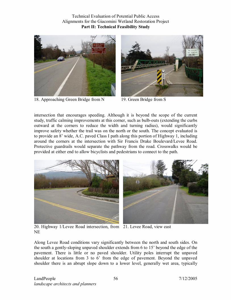
3.8.a Construction The first portion of this alignment requires special consideration because it in the Caltrans right-of-way and because it involves two bridges and a major intersection at Highway 1 and Sir Francis Drake Boulevard. Caltrans is not likely to accept less than its full bikeway standards in this setting. One issue is that if a multi-use path is to be provided in lieu on bike lanes or informal use of the shoulders by bikes, provisions for bikes to cross at the beginning and end of the path are required. If this portion of the path starts at B Street and ends at Levee Road, crosswalks across Highway 1 would be required at each end point. Moving south from B Street in Point Reyes Station, the first construction requirement for the path would be a short bridge over an unnamed creek flowing through a box culvert/bridge under Highway 1. The existing culvert is approximately 30’ wide and the span for an 8’ wide prefabricated fiberglass trail bridge is assumed to be 40’ in order to provide setbacks from the creekbanks. Beyond this bridge the existing road shoulder is not wide enough to accommodate a 6’wide trail without reducing the available road shoulder. A safety barrier and construction of a retaining wall to support the trail is recommended to minimize impact on the adjacent riparian vegetation. The existing Green Bridge is approximately 100’ long. It has a 5’ wide boardwalk on the west side, and virtually no shoulders for bikes on the bridge itself. An option to modify the bridge to provide an 8’ wide multi-use path on the west has been estimated (see Figure 14). This could be accomplished by replacing the existing steel beams supporting the boardwalk with longer members, and replacing the current railing with a higher one. Continuing south, a 4 to 5’ wide pathway around the northwest corner of the intersection of Highway 1 and Sir Francis Drake Boulevard is formed by an AC curb. This path is not adequate for accommodating multiple uses. Due to the close proximity of the structure on the corner, the only practical means of creating the 8’ standard bikeway width would be to utilize some of the shoulder of the roadway and place a safety barrier between the road and the trail. Depending on if a path is being considered on the south side of Levee Road (Alignment 4d) or on the north side (Alignment 4e), a crosswalk across the Levee Road portion of Sir Francis Drake Boulevard may be required at this point. This is a very wide
Technical Evaluation of Potential Public Access Alignments for the Giacomini Wetland Restoration Project
Part II: Technical Feasibility Study
LandPeople 56 7/12/2005 landscape architects and planners
intersection that encourages speeding. Although it is beyond the scope of the current study, traffic calming improvements at this corner, such as bulb-outs (extending the curbs outward at the corners to reduce the width and turning radius), would significantly improve safety whether the trail was on the north or the south. The concept evaluated is to provide an 8’ wide, A.C. paved Class I path along this portion of Highway 1, including around the corners at the intersection with Sir Francis Drake Boulevard/Levee Road. Protective guardrails would separate the pathway from the road. Crosswalks would be provided at either end to allow bicyclists and pedestrians to connect to the path.
Along Levee Road conditions vary significantly between the north and south sides. On the south a gently-sloping unpaved shoulder extends from 6 to 15’ beyond the edge of the pavement. There is little or no paved shoulder. Utility poles interrupt the unpaved shoulder at locations from 3 to 6’ from the edge of pavement. Beyond the unpaved shoulder there is an abrupt slope down to a lower level, generally wet area, typically
18. Approaching Green Bridge from N 19. Green Bridge from S
20. Highway 1/Levee Road intersection, from NE
21. Levee Road, view east
Technical Evaluation of Potential Public Access Alignments for the Giacomini Wetland Restoration Project
Part II: Technical Feasibility Study
LandPeople 57 7/12/2005 landscape architects and planners
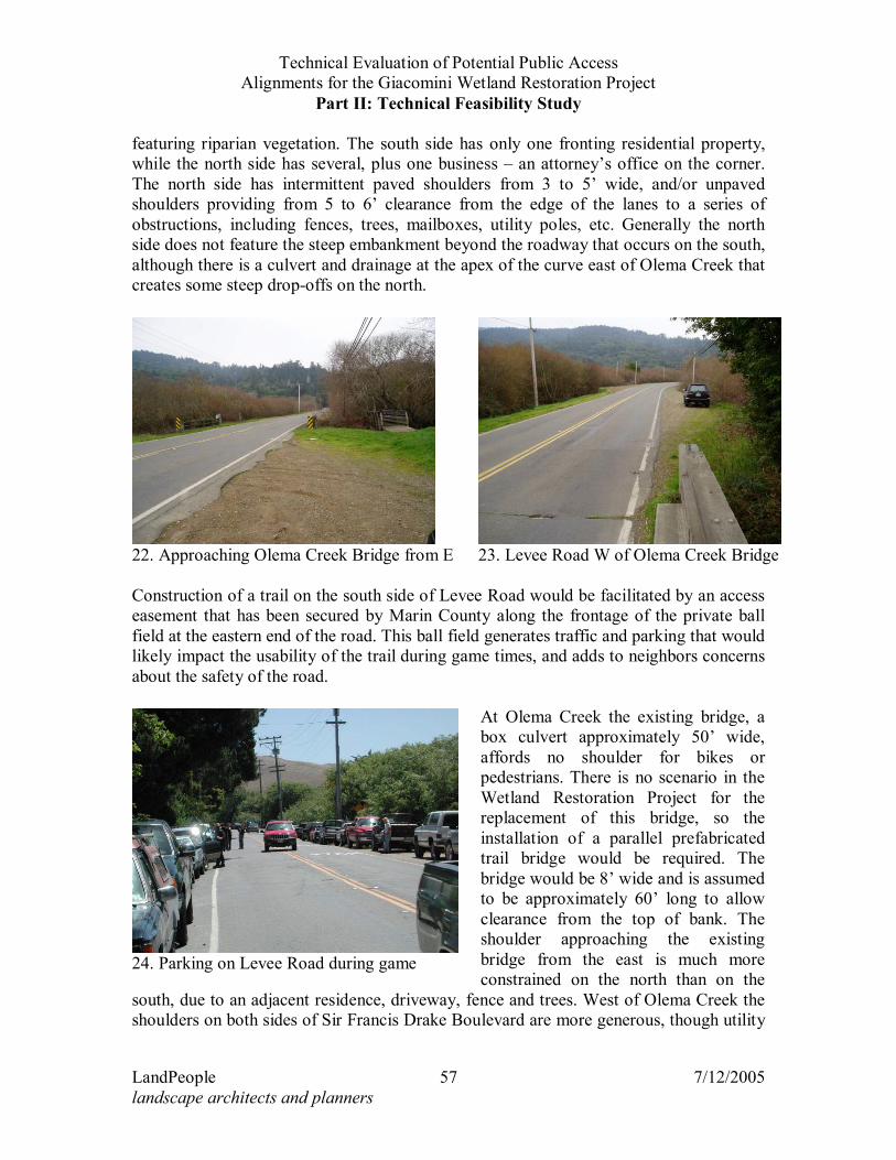
featuring riparian vegetation. The south side has only one fronting residential property, while the north side has several, plus one business – an attorney’s office on the corner. The north side has intermittent paved shoulders from 3 to 5’ wide, and/or unpaved shoulders providing from 5 to 6’ clearance from the edge of the lanes to a series of obstructions, including fences, trees, mailboxes, utility poles, etc. Generally the north side does not feature the steep embankment beyond the roadway that occurs on the south, although there is a culvert and drainage at the apex of the curve east of Olema Creek that creates some steep drop-offs on the north.
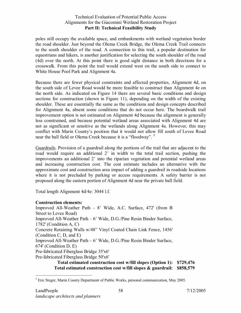
Construction of a trail on the south side of Levee Road would be facilitated by an access easement that has been secured by Marin County along the frontage of the private ball field at the eastern end of the road. This ball field generates traffic and parking that would likely impact the usability of the trail during game times, and adds to neighbors concerns about the safety of the road.
At Olema Creek the existing bridge, a box culvert approximately 50’ wide, affords no shoulder for bikes or pedestrians. There is no scenario in the Wetland Restoration Project for the replacement of this bridge, so the installation of a parallel prefabricated trail bridge would be required. The bridge would be 8’ wide and is assumed to be approximately 60’ long to allow clearance from the top of bank. The shoulder approaching the existing bridge from the east is much more constrained on the north than on the
south, due to an adjacent residence, driveway, fence and trees. West of Olema Creek the shoulders on both sides of Sir Francis Drake Boulevard are more generous, though utility
22. Approaching Olema Creek Bridge from E 23. Levee Road W of Olema Creek Bridge
24. Parking on Levee Road during game
Technical Evaluation of Potential Public Access Alignments for the Giacomini Wetland Restoration Project
Part II: Technical Feasibility Study
LandPeople 58 7/12/2005 landscape architects and planners
poles still occupy the available space, and embankments with wetland vegetation border the road shoulder. Just beyond the Olema Creek Bridge, the Olema Creek Trail connects to the south shoulder of the road. A connection to this trail, a popular destination for equestrians and hikers, is another justification for selecting the south shoulder of the road (4d) over the north. At this point there is good sight distance in both directions for a crosswalk. From this point the trail would extend west on the south side to connect to White House Pool Park and Alignment 4a. Because there are fewer physical constraints and affected properties, Alignment 4d, on the south side of Levee Road would be more feasible to construct than Alignment 4e on the north side. As indicated on Figure 14 there are several basic conditions and design sections for construction (shown in Figure 11), depending on the width of the existing shoulder. These are essentially the same as the conditions and design concepts described for Alignment 4a, absent some conditions that do not occur here. The boardwalk trail improvement option is not estimated on Alignment 4d because the alignment is generally less constrained, and because potential wetland areas associated with Alignment 4d are not as significant or sensitive as the wetlands along Alignment 4a. However, this may conflict with Marin County’s position that it would not allow fill south of Levee Road near the ball field or Olema Creek because it is a “floodway”. 5 Guardrails. Provision of a guardrail along the portions of the trail that are adjacent to the road would require an additional 2’ in width to the total trail section, pushing the improvements an additional 2’ into the riparian vegetation and potential wetland areas and increasing construction cost. The cost estimate includes an alternative with the approximate cost and construction area impact of adding a guardrail in roadside locations where it is not precluded by parking or access requirements. A safety barrier is not proposed along the eastern portion of Alignment 4d near the private ball field. Total length Alignment 4d/4e: 3044 l.f. Construction elements: Improved All-Weather Path – 8’ Wide, A.C. Surface, 472' (from B Street to Levee Road)
Improved All-Weather Path – 6’ Wide, D.G./Pine Resin Binder Surface, 1782' (Condition A, C)
Concrete Retaining Walls w/48” Vinyl Coated Chain Link Fence, 1456' (Condition C, D, and E)
Improved All-Weather Path – 6’ Wide, D.G./Pine Resin Binder Surface, 674' (Condition D, E)
Pre-fabricated Fiberglass Bridge 35'x6' Pre-fabricated Fiberglass Bridge 50'x6'
Total estimated construction cost w/fill slopes (Option 1): $729,476 Total estimated construction cost w/fill slopes & guardrail: $858,579
5 Eric Steger, Marin County Department of Public Works, personal communication, May 2005.
Technical Evaluation of Potential Public Access Alignments for the Giacomini Wetland Restoration Project
Part II: Technical Feasibility Study
LandPeople 59 7/12/2005 landscape architects and planners
Total estimated construction cost w/retaining walls (Option 2): $950,147 Total estimated construction cost w/ retaining walls & guardrail: $1,198,172
Estimated Construction Area Impacts: Option 1 Option 2 Total Square Footage for Impacted Area: 22,203 s.f. 14,075 s.f. 3'W Construction Access Impact Area: 8,997 s.f. 8,997 s.f. Total Square Footage of Construction Area Impact:
31,200 s.f. 23,072 s.f.
Total Square Footage of Construction Area Impact w/ Optional Guardrail: 38,693 s.f. 30,051 s.f.
3.8.b Maintenance Maintenance requirements for this section are similar to those for the comparable parts of Alignment 4a. The Green Bridge walkway is assumed to remain part of Caltrans maintenance responsibilities. Total estimated annual maintenance/replacement cost for Alignment 4d with Option 1, fill slopes, is 15,064; with Option 2, retaining wall, the estimate is $19,518.
3.8.c Land Use Impacts The primary land use impact of Alignment 4d, on the west side of Highway 1 and on the south side of Levee Road would be on the attorney’s office at the northwest corner of the intersection, where the Green Bridge and the existing path would need to be widened to create a Class I path, and at the single residence on the south side of the road. Both these uses could be impacted by noise, litter, and visual intrusion from increased trail use, as well as temporary noise and dust during trail construction. Residences on the north side of Levee Road could also be impacted, but to a much lesser extent. Though not technically a land use impact, the trail could change the visual character of the area by adding fill, walls or boardwalks, new trail bridges, expanding the existing Green Bridge structure. Adding guardrail safety barriers could also be a significant change. A potential land use conflict could occur between use of the trail and parking along Levee Road for the private ball field on the south side. Although the roadside parking is not formally dedicated for parking for this use, it would definitely conflict with the trail use. Conversely, if a safety barrier is installed for the trail, it would prevent the shoulder from being used for parking. Therefore a safety barrier is not proposed along the eastern portion of Alignment 4d near the private ball field.
Technical Evaluation of Potential Public Access Alignments for the Giacomini Wetland Restoration Project
Part II: Technical Feasibility Study
LandPeople 62 7/12/2005 landscape architects and planners
3.9 PLATFORM/OVERLOOK LOCATION 1 – AT TRAIL ALIGNMENT 1A The viewing platforms or overlooks (see Figure 2 for locations) are conceptually described to provide a basis for environmental impact evaluation and estimation of construction and maintenance cost ranges. The design concepts vary from location to location to respond to specific site opportunities and constraints. Overlook Location 1 is on a slope overlooking the wetlands at the existing entrance to Trail Alignment 1a, one of the existing social paths. It could be a slightly elevated viewing platform with interpretative installations It may be designed as a blind to minimize disturbance to wildlife. Depending on date of construction, some riparian habitat may need to be removed to enable construction. Currently, a relatively large unvegetated opening exists, because of construction access needs associated with repair of the West Pasture levee and tidegate on Fish Hatchery Creek. This viewing platform would enable visitors to view the existing undiked tidal marsh to the north and the northern end of the West Pasture.
3.9.a Construction This overlook could be constructed on-grade with a low retaining wall supporting a decomposed granite-surfaced area, or as a deck. To allow observation of wildlife without disturbing them, the platform would feature a wood screen fence, with viewing ports. Railings, benches and plaques with interpretive information about the Wetland Restoration and the wildlife would complete the improvements. Total estimated construction cost: Small structure, retaining wall and D.G. surface, wood screen and benches
$5,000 - $10,000
3.9.b Maintenance
Depending on materials used the platform could require very little maintenance, but wood components would eventually would need to be resurfaced, and finally, replaced . The wood screen, bench, and interpretive display components would need to be refinished and have minor repairs at an estimated 5 year interval, and be replaced at estimated 10 year intervals. Total estimated annual maintenance/replacement cost for Overlook 1 is $300 - $700. 3.10 PLATFORM/OVERLOOK LOCATION 2 – AT WHITE HOUSE POOL PARK, TRAIL
ALIGNMENT 4A This potential public access component would involve creation of an elevated overlook and interpretative exhibit at White House Pool County Park. It would be located generally north of the County Park parking lot near an existing bridge that is often used by Park visitors for bird-watching. It may be designed as a blind to minimize disturbance to wildlife. It would be developed with full approval of and cooperation with the land
Technical Evaluation of Potential Public Access Alignments for the Giacomini Wetland Restoration Project
Part II: Technical Feasibility Study
LandPeople 63 7/12/2005 landscape architects and planners
owners, the Wildlife Conservation Board, and the lessees, County Parks. This elevated overlook would enable visitors to view the restored marsh and uplands in the Giacomini East Pasture and birds and other species using the southern portion of Lagunitas Creek within the Project Area.
3.10.a Construction The potentially ADA-compliant structure would take the form of a deck elevated above existing grade. A potentially ADA-compliant path would lead from the County White House Pool parking lot to the overlook. The platform could feature screen fence with viewing ports at varying heights to accommodate different users. Railings, benches, and plaques would complete the improvements. Total estimated construction cost: Larger structure, wood screen and benches on elevated wood deck and ADA accessible ramp
$50,000 - $100,000
3.10.b Maintenance
The wood deck, railing, screen, bench, and interpretive display components would need to be refinished and have minor repairs at an estimated 5 year interval, and be replaced at estimated 10 year intervals. If recycled plastic lumber is used for the non-structural components, the refinishing would be eliminated but minor repair would still be required at estimated 5 year intervals. The non-structural component replacement interval would be extended. Total estimated annual maintenance/replacement cost for Overlook 2 is $2,000 - $4,000. 3.11 PLATFORM/OVERLOOK LOCATION 3 – NEAR GIACOMINI DAIRY, TRAIL
ALIGNMENT 4A This potential public access component would involve creation of a viewing area and interpretative exhibit at the existing Giacomini dairy facility (see Figure 2). The westernmost portion of the dairy facility, which is located adjacent to the town of Point Reyes Station on the Point Reyes Mesa, is owned by the NPS and will come under full management in 2007. It would accessed by a potentially ADA-compliant path from 6th Street so as to minimize impacts on residents in town. Currently, this area contains the Old Calf Barn, along with some manure ponds, which the NPS proposes to remove. This facility would enable visitors to view the restored marsh and uplands in the Giacomini East Pasture and birds and other species using the southern portion of Lagunitas Creek within the Project Area. Because it would be located at a higher elevation, it would provide a broader view of the restored Project Area than some of the other potential facilities such as Viewing Platform/Elevated Overlook Locations 1 and 2.
Technical Evaluation of Potential Public Access Alignments for the Giacomini Wetland Restoration Project
Part II: Technical Feasibility Study
LandPeople 64 7/12/2005 landscape architects and planners
3.11.a Construction This viewing location would not need to be elevated, because it is already at a relatively high elevation. As this would be the closest location to town, it would presumably receive more visitor use. Interpretative plaques and displays would inform visitors about the restoration project, history of wetlands in the area, history of dairy ranching in Point Reyes, or other subjects. This overlook would be combined with the designated trailhead for Sub-Alignment 4a-I. Total estimated construction cost: Large, low seat wall structure w/ D.G. surface $15,000 - $30,000
3.11.b Maintenance The maintenance requirements would be similar to viewing platform location 1, with a proportional increase due to the larger size of the facility. Additional maintenance would be required due to landscaping being incorporated. Total estimated annual maintenance/replacement cost for Overlook 3 is $2,000 - $4,000. 3.12 PLATFORM/OVERLOOK LOCATION 4 – AT GIACOMINI HUNT SHACK, TRAIL
ALIGNMENT 2D This potential public access component would involve creation of a viewing platform and interpretative exhibit near the Giacomini Hunt Shack at the end of Trail Alignment 2d. The facility would be constructed on lands owned by the NPS. However, as a condition of the property sale in 2000, the Giacominis retained a 25-year reservation of use agreement on the Hunt Shack. Any siting of a facility in this area would need to ensure that the Giacominis were able to access the Hunt Shack for the duration of this reservation of use agreement. Currently, this area is used for storage of agricultural equipment and is largely vegetated with ruderal or weedy plant species. This facility would enable visitors to view the restored marsh and uplands in the central portion of the Giacomini East Pasture. Because it would be located on the top of the historic railroad grade berm, it would provide a slightly broader view of the restored Project Area than some of the other potential facilities such as platform/overlook locations 1 and 2, but not as broad a view as platform/overlook location 3.
3.12.a Construction Construction features could be the same as platform/overlook location 3, but at a smaller size. Total estimated construction cost: Small, low seat wall structure w/ D.G. surface $13,098
Technical Evaluation of Potential Public Access Alignments for the Giacomini Wetland Restoration Project
Part II: Technical Feasibility Study
LandPeople 65 7/12/2005 landscape architects and planners
3.12.b Maintenance Maintenance requirements would be similar to platform/overlook locations 2, but reduced proportionately because there would be no screening fence or landscaping, and the size would be smaller than location 2. Total estimated annual maintenance/replacement cost for Overlook 4 is $1,000 - $2,000.
3.12.c Land Use Impacts Neighbors on Mesa Road have expressed concern about the potential for noise and other impacts associated with this conceptual overlook location. 3.13 PLATFORM/OVERLOOK LOCATION 5 – NEAR END OF TOMALES BAY TRAIL, TRAIL
ALIGNMENT 2E This potential public access component would involve creation of a viewing area and interpretative exhibit near the end of the Tomales Bay Trail at the top of Railroad Point hilltop. The facility would be constructed on lands owned by the NPS and leased to the Martinelli family. Any siting of a facility in this area would need to ensure that terms of the lease agreement are not violated. Currently, this area is grassland that is used for grazing of beef cattle. Despite this, the vegetation community supports a fairly high percentage of plant species that are native to California grasslands. California’s grasslands have been severely impacted by the introduction and spread of non-native plant species, particularly grasses, that thrive in areas with high disturbance. This facility would enable visitors to view the restored marsh and uplands in the northern portion of the Project Area, as well as the historic marsh in southern Tomales Bay. Of all the proposed viewing platforms or elevated overlook facilities, it would provide the broadest overview of the restored Project Area and Tomales Bay, although visitors seeking to bird watch would probably move down the trail closer to the Bay.
3.13.a Construction This overlook/viewing platform would be the most remote for construction and maintenance, and would be at the most elevated site, so the design and construction should be the simplest. At this location, it is possible that the infrastructure would be limited to an interpretative sign and potentially a wooden log bench. Total estimated construction cost: Small D.G. surfaced area with wooden bench(es) and interpretive sign
$2,000 - $5,000
3.13.b Maintenance
Maintenance would be minimal, limited to repair or replacement of interpretive installations. Total estimated annual maintenance/replacement cost for Overlook 5 is $200.