Embed Size (px)
Citation preview

Paul L. Decker
Alaska Department of Natural Resources, Division of Oil and Gas September 15, 2011


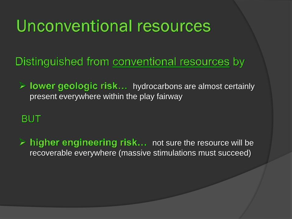
hydrocarbons are almost certainly present everywhere within the play fairway
not sure the resource will be recoverable everywhere (massive stimulations must succeed)

Some are synonyms, others are not
Resource plays Continuous accumulations Basin-centered accumulations Technology reservoirs Tight oil / gas Shale gas / shale oil (≠ oil shale)

mining or in-situ retort
(modified from Sonnenberg, 2010)


Seismic transect
Great Bear Petroleum 2010 lease purchase
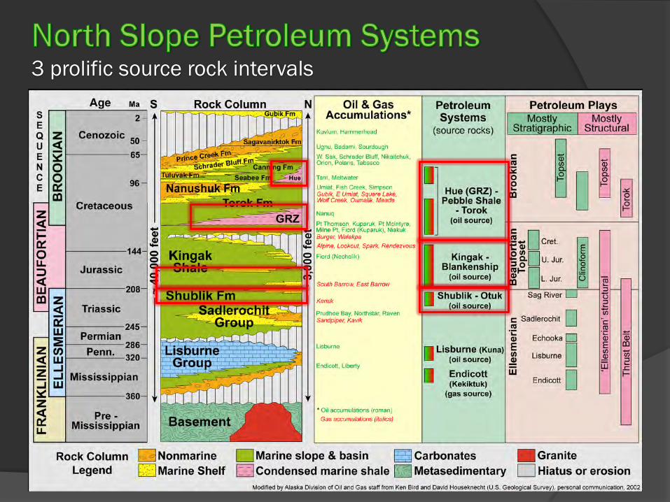
3 prolific source rock intervals

Hue Shale/GRZ Cretaceous age, younger offshore to northeast Shale deposited in sediment-starved & oxygen-depleted deep foreland basin Separate tongues of different ages in west that coalesce eastward Abundant volcanic ash beds altered to sticky clays (plastic behavior?) Source of Tarn field oil (37 deg API)
lower Kingak Formation Early Jurassic age (just above Shublik Formation) Shale deposited on sediment-starved & oxygen-depleted platform margin Few well penetrations to south, rare outcrops in foothills Lack details on regional distribution and source-reservoir characteristics Source of Alpine field oil (40 deg API)
Shublik Formation Late Triassic age (just below Kingak Formation) Phospatic limestone, shale, sandstone, & siltstone deposited on nutrient-rich
upwelling-influenced continental margin Few well penetrations to south, common outcrops in foothills Lack details on most source-reservoir characteristics Source of Kuparuk field oil (24 deg API)
olde
r & d
eepe
r
you
nger
& s
hallo
wer

West East
Shublik + Lower Kingak
GRZ + Hue Sh
GRZ
• GRZ-Hue Sh at ~8,000 – 13,000 ft depth • Shublik + Lower Kingak at ~10,000 – 11,000 ft depth
(Decker, unpublished data, 2010-11)
Base permafrost


Organic Geochemistry Total Organic Carbon content (richness) Hydrogen Index (oil-prone, gas-prone, or inert kerogen types) Oil properties (gravity, in-situ viscosity, wax & asphaltene content, etc.)
Thermal and Tectonic History Thermal maturity (immature oil window gas window supermature) Stress-strain history (# of phases of natural fracturing, etc.) Current stress regime (determines orientation of artificial fractures and whether
natural fractures are propped open)
Petrophysics Porosity (void space between grains, within grains, and in fractures) Permeability (how connected are pore spaces?) Relative Permeability (oil, gas, water – which flows more readily?)
Geomechanics -- Is the rock brittle enough to create and sustain fractures? Cement content and types (carbonate, silica, sulfides, etc.) Grain content and types (silt, sand, fossil debris, etc.) Layering (thickness and mechanical contrast)
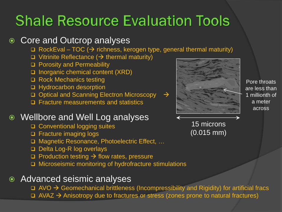
Core and Outcrop analyses RockEval – TOC ( richness, kerogen type, general thermal maturity) Vitrinite Reflectance ( thermal maturity) Porosity and Permeability Inorganic chemical content (XRD) Rock Mechanics testing Hydrocarbon desorption Optical and Scanning Electron Microscopy Fracture measurements and statistics
Wellbore and Well Log analyses Conventional logging suites Fracture imaging logs Magnetic Resonance, Photoelectric Effect, … Delta Log-R log overlays Production testing flow rates, pressure Microseismic monitoring of hydrofracture stimulations
Advanced seismic analyses AVO Geomechanical brittleness (Incompressibility and Rigidity) for artificial fracs AVAZ Anisotropy due to fractures or stress (zones prone to natural fractures)
15 microns (0.015 mm)
Pore throats are less than 1 millionth of
a meter across

Source rock systems
USGS currently assessing technically recoverable resources in source-rock systems of the North Slope Public geology review meeting in Anchorage on October 25, 2011 Present and solicit feedback on geological framework and assumptions Methodology and L48 analogues
Basic resource assessment method: Determine cell size drained by a single well (e.g., 80 or 160 acres) Divide the play area into cells Determine probabilistic range of Estimated Ultimate Recovery (EUR) per well
• production data • analogues
Technically recoverable volume = EUR per cell x Number of cells


Infrastructure-intensive development
(courtesy Lynn Helms NDIC, DMR, 2011 )
(Canadian Business Resources
70 acres total surface impact (14 pads, 5 acres each) 17,920 acres of subsurface
development (2 mile-long laterals on each side of road times 7 miles length times 640 acres/mi2)

Infrastructure-intensive development
(Paneitz/ Whiting Petroleum, 2010)
Bakken Shale 640 acres/well (Sanish & Parshall Fields) Eagle Ford Shale 125-140 acres/well (EOG plans) North Slope ? 120-160 acres/well (Great Bear estimates)

How do they work?
Fluid (water + sand + additives for gelling and gel-breaking, etc.) is pumped into an isolated part of the borehole under increasing pressure. When the fluid pressure exceeds the rock strength, the formation fractures and the sand-rich fluid shoots out into the growing cracks. The sand props the fractures open after the frac fluid flows back into the wellbore.
How much water do they use? Frac jobs for horizontal producers in L48 shale plays consume 1 to 5.5 million gallons of water (and millions of pounds of sand) per well, depending on rock properties, number of stages pumped, etc. (For comparison, ice roads require 1-1.5 million gallons per mile.)
What are the environmental risks? Contamination of fresh water aquifers with hydrocarbons and/or frac fluids is a potential concern where the hydrocarbon target and aquifer are not sufficiently separated. THIS IS AVOIDABLE!

Kuparuk Uplands, White Hills, Franklin Bluffs, Foothills
(National Geographic, 2006; http://ngm.nationalgeographic.com/ngm/0605/feature1/map.html)
KU
WH
FB
Foothills & Brooks Range
Foothills & Brooks Range

Source: EQT Energy, 2011 (http://www.eqt.com/docs/pdf/FluidCompositions/Well512456.pdf)
Composition for a 16-stage West Virginia Marcellus Shale well
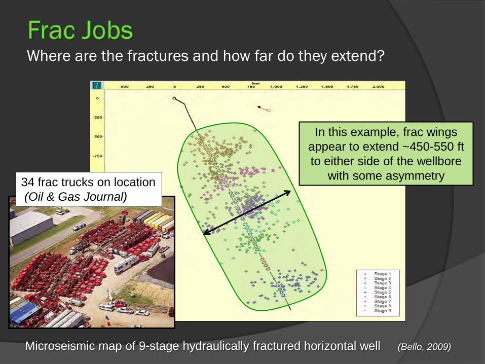
Where are the fractures and how far do they extend?
Microseismic map of 9-stage hydraulically fractured horizontal well (Bello, 2009)
In this example, frac wings appear to extend ~450-550 ft to either side of the wellbore
with some asymmetry 34 frac trucks on location (Oil & Gas Journal)

Where are the fractures and how far do they extend?
24-stage Bakken Formation frac (Whiting Petroleum, 2011)

(Bello, 2009)
Shale gas well example
Rate drops off sharply early on
Lower rate continues for a long time at shallow decline rate

(Whiting Petroleum, 2011)
One producer’s average production profile for Bakken Formation production wells – North Dakota
• Successful shale wells produce at a relatively high initial rate
• Rates decline sharply early on, then decline more slowly
• Individual wells may produce for decades (depending on costs, etc.)

Upper Cretaceous Eagle Ford Shale (Boquillas Fm)

(Treadgold and Nicklin, 2011)
Upper Cretaceous Eagle Ford Shale

(http://eagleford info.blogspot.com)
Upper Cretaceous Eagle Ford Shale
(Energy Information
Administration, 2010)
• Brittle: up to 70% calcite
• 50-250 ft thick; potentially all net pay
• 2-7%TOC
• Extensive area of thermal maturity
• Porosity 7-15%
• Narrow overpressure zone

Devonian-Mississippian Bakken Fm – shale sandwich
(modified after Sonnenberg, 2011)

151 Active Drilling Rigs in
Williston Basin,
January 2011
Devonian-Mississippian Bakken Fm – First 60-90 day oil rates
(Nordeng, 2010; Nordeng and others, 2010)
• Brittle: siliceous & pyritic shales; dolomitic siltstone middle member • Up to 100 ft thick “shale sandwich”
• Rich: 11% average TOC; up to 40%
• Oil-prone Type I/II kerogen
• Extensive area of thermal maturity
• Porosity 8-12%
• Permeability 0.05 – 0.5 mD
• Sweet spots relate to major flexures natural fractures
early oil window maturity overpressure

North Dakota Industrial Commission, Department of Mineral Resources
(courtesy Lynn Helms NDIC, DMR, 2011 )
• Well Cost, Horizontal Producer $6.1 million (47 jobs) • Operating Cost, Monthly < $7,000 (1 job) • Royalty Rate 16.7% • Average Initial Production Rate 955 BOPD • Breakeven IP Oil Rate 235 BOPD • Breakeven Reserves per well 183,000 bbl • Breakeven Reserves Success 83%
Marathon, Brigham, Whiting
average well


Kavik River area outcrops
Interbedded shale, limestone, silty-muddy, phosphatic, pyritic (600 ft thick)

Well logs and zonation Rock Flour 1
lower Kingak Fm
Sag River Fm
Sadlerochit Gp
Zone A
Zone B
Zone C
Zone D
Shublik Fm

Well logs and zonal correlations
(Decker, unpublished data, 2011)
S Harr Bay 1 Kookpuk 1 KRU 2F-20 Rock Flour 1 Hemi Spr 3 Toolik 1 Hemi Spr 1
lower Kingak Sag River
Shublik A-D

Oil-saturated lime mudstone fault breccia, Kukpowruk River

Kemik gas field: Naturally fractured reservoir (?)
Gamma SP Resistivity Density Sonic
Shublik Fm
Zone A
Zone B
Zone C
Zone D
Fire Cr Sltst
Sag River Ss
HWPT No. 2 Shublik A-C: ~10 MMCFD
Shublik A-B: 12 MMCFD (AOF?) DST No. 2
HWPT No. 1B Shublik C: ~2 MMCFD
Gas Flow Rates
Kemik Unit 1
Gamma SP Resistivity Density Sonic Gamma SP Resistivity Density Sonic
Shublik Fm
Ivishak Fm
Sag River Ss
zonal correlations uncertain
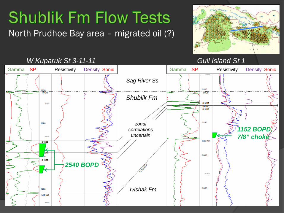
North Prudhoe Bay area – migrated oil (?)
1152 BOPD, 7/8” choke
W Kuparuk St 3-11-11 Gull Island St 1
2540 BOPD

NPRA
ANWR 1002
ANWR
Gates of the Arctic
Noatak
ASRC
ASRC
Hydrogen Index and Thermal Maturity
(overlay figure from Peters and others, 2006)
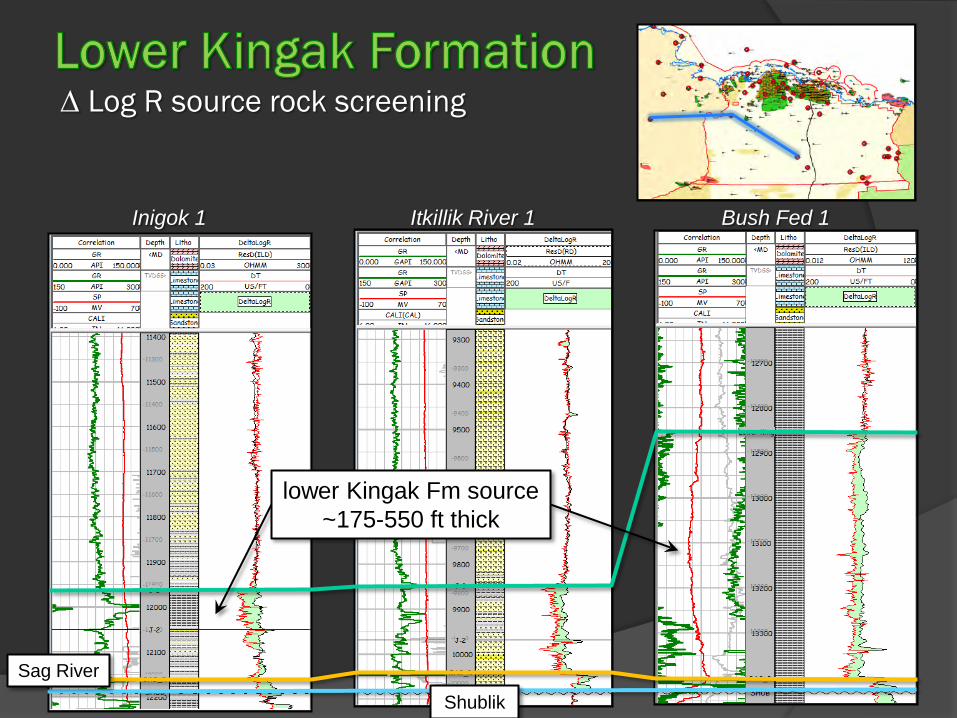
∆ Log R source rock screening
Itkillik River 1 Inigok 1 Bush Fed 1
lower Kingak Fm source ~175-550 ft thick
Sag River
Shublik

NPRA
ANWR 1002
ANWR
Gates of the Arctic
Noatak
ASRC
ASRC
Hydrogen Index (??) and Thermal Maturity
(overlay figure from Peters and others, 2006)
? ?
? ?
?

Type section outcrops at Hue Creek, ANWR

Correlation Section and ∆ Log R Total Organic Content estimates
Itkillik R 1 Narvaq 1 Atlas 1 W Sak 26 Toolik 2 Hemi Spr 3
Hue
Hue Hue
GRZ GRZ
GRZ 2.4%
Hue Sh 4.9%
1.6% 2.6%
2.6%
5.0%
3.1%
3.1%
4.8% (?)
10.3% (?)
Torok
Torok
Seabee Canning
(Decker, unpublished data, 2009)
LCU
∆ Log R calculated TOC estimates

NPRA
ANWR 1002
ANWR
Gates of the Arctic
Noatak
ASRC
ASRC
Average Hydrogen Index and Thermal Maturity
(overlay figure from Peters and others, 2006)

Geologic characteristics
(compiled from various sources, Decker, 2011)


North Slope Foothills Areawide Sale
Beaufort Sea Areawide Sale
North Slope Areawide Sale
Rescheduled to December 7-- All available unleased State tracts

Three competitive oil and gas lease sales encompassing 14.7 million acres, re-scheduled to December 7, 2011.
North Slope Areawide o Encompasses 5.1 million acres onshore, including the core producing area north of
the Umiat baseline between NPRA and ANWR
o Barrow Arch crest and southern flank, northern Colville Basin
o Conventional oil and gas prospects in structural, stratigraphic, and combination traps
o Shale oil fairway as currently understood
Beaufort Sea Areawide o Encompasses 2 million acres in state waters and coastal areas
o Barrow Arch and faulted northern margin
o Oil and gas prospects in extensional, stratigraphic, and combination traps
North Slope Foothills Areawide o Encompasses 7.6 million acres south of the Umiat baseline between NPRA and
ANWR o Colville Basin and Brooks Range foothills o Mainly gas prospects in compressional anticlines

Shublik/Kingak Hue/GRZ Shublik/Kingak
Now scheduled for December 7, 2011
Leased Available
(July 2011)

Many variables impact productivity of source-reservoired oil and gas o Organic geochemistry o Thermal and tectonic history o Petrophysics o Geomechanics o Drilling and completion practices
Development of North Slope shale oil will likely depend on o Successful exploration drilling, data gathering to establish geological favorability o Successful production pilot project(s) o Lowering drilling and operating costs o All-season roads for year-round surface access to new areas o More hydraulic frac crews o Sufficient water supplies for frac make-up fluid o Factual understanding and operator transparency regarding frac practices

References Cited Bello, R.O., 2009, Rate transient analysis in shale gas reservoirs with transient linear behavior: Texas A&M University doctoral dissertation, 190 p., accessed online January 4, 2011. http://www.pe.tamu.edu/wattenbarger/public_html/Dissertations%20and%20Theses/2009%20PhD%20-%20Bello.pdf Canadian Business Resources, 2011, Corporate profile., accessed online January 16, 2011. http://www.cbr.ca/CompanyProfile.aspx?CompanyID=7505 DOE-NETL, 2010, Using artificial barriers to augment fresh water supplies in shallow Arctic lakes, grant DE-NT0005684; accessed online February 1, 2011. http://www.netl.doe.gov/technologies/oil-gas/Petroleum/projects/EP/ArcticResources/05684ArcticLakes.html EQT Energy, 2011, Hydraulic fracturing fluid compositions, accessed online February 1, 2011. http://www.eqt.com/docs/pdf/FluidCompositions/Well512456.pdf Kupecz, J.A., 1995, Depositional setting, sequence stratigraphy, diagenesis, and reservoir potential of a mixed-lithology, upwelling deposit: Upper Triassic Shublik Formation, Prudhoe Bay, Alaska: American Association of Petroleum Geologists Bulletin, v. 79, p. 1301-1319. Lefever, J.A., 2008, Rock-Eval data of the Bakken Formation: North Dakota Geological Survey Geologic Investigations No. 63, 6 sheets, accessed online January 11, 2011. https://www.dmr.nd.gov/ndgs/bakken/bakkenthree.asp National Geographic, 2006, Alaska’s North Slope interactive map, accessed online February 1, 2011. http://ngm.nationalgeographic.com/ngm/0605/feature1/map.html Nordeng, S.H., 2010, First 60 - 90 day average Bakken pool production by well: North Dakota Geological Survey Geologic Investigations No. 123, 1 sheet, accessed online January 11, 2011. https://www.dmr.nd.gov/ndgs/bakken/bakkenthree.asp Nordeng, S.H., Lefever, J.A., Anderson, F.J., and Johnson, E.H., 2010, Oil generation rates and subtle structural flexure: keys to forming the Bakken sweetspot in the Parshall field of Mountrail County, North Dakota: American Association of Petroleum Geologists, Search and Discovery Article #20094, accessed online January 13, 2011. http://www.searchanddiscovery.net/documents/2010/20094nordeng/ndx_nordeng.pdf?zbrandid=4051&zidType=CH&zid=5123844&zsubscriberId=1000997127&zbdom=http://aapg.informz.net Paneitz, J./ Whiting Petroleum, 2010, Evolution of the Bakken completions, Sanish field, Williston Basin, North Dakota; SPE conference, Keystone, Colorado, August 6, accessed online January 16, 2011. http://phx.corporate-ir.net/External.File?item=UGFyZW50SUQ9NTc1NTV8Q2hpbGRJRD0tMXxUeXBlPTM=&t=1 Peters, K.E., Magoon, L.B., Bird, K.J., Valin, Z.C., and Keller, M.A., 2006, North Slope Alaska: source rock distribution, richness, thermal maturity, and petroleum charge: American Association of Petroleum Geologists Bulletin, v. 90, p. 261-292. Sonnenberg, S., 2011, The Bakken petroleum system of the Williston Basin: American Association of Petroleum Geologists online seminar presentation. Whiting Petroleum, 2011, Current corporate information, January, accessed online January 16, 2011. http://phx.corporate-ir.net/External.File?item=UGFyZW50SUQ9Nzc2ODV8Q2hpbGRJRD0tMXxUeXBlPTM=&t=1


![guaSC[1] - Alaska Department of Natural Resourcesdnr.alaska.gov/mlw/gcp/gua/pdfs/guaSC.pdfGuide Use Area Boundaries and Identification Numbers: Alaska Department of Fish and Game,](https://img.pdfslide.net/doc/110x75/5fce5e820979dc358d39cff5/guasc1-alaska-department-of-natural-guide-use-area-boundaries-and-identification.jpg)