Embed Size (px)
Citation preview
Version 10.0 2021
PBN IMPLEMENTATION PLAN FOR IRELAND
COMMENTS AND OBSERVATIONS TO: [email protected]

Page 2 of 28
Table of Contents
1. Document Change Control Sheet ..................................................................................... 3 2. Acronyms .......................................................................................................................... 4 3. Executive Summary........................................................................................................... 6 4. Background ......................................................................... Error! Bookmark not defined. 5. Stakeholders Roles ............................................................................................................ 8 6. SESAR ................................................................................................................................ 9 7. Fundamental assumptions for the future system in the EU ........................................... 10 8. Proposed layout of the future system ............................................................................ 12 9. En-route .......................................................................................................................... 13 10. TMA Procedures ............................................................................................................. 14 11. Non-Precision Runways. ................................................................................................. 14 12. Precision Instrument Runways ....................................................................................... 15 13. Mixed mode operations.................................................................................................. 15 14. Back-up solutions ............................................................................................................ 15 15. Non-GNSS ANS failure ..................................................................................................... 15 16. Failure of primary navigation infrastructure .................................................................. 16 17. Transition and rationalisation of the ground-based navigation infrastructure .............. 17 18. Aircraft ............................................................................................................................ 17 19. Safety – Risks Associated with Major System Change .................................................... 18 20. Environment ................................................................................................................... 19 21. Infrastructure Development ........................................................................................... 20 22. Operational ..................................................................................................................... 21 23. Helicopter Operations .................................................................................................... 21 24. Implementation .............................................................................................................. 21 25. Tables’ Legend ................................................................................................................ 22 26. Routes ............................................................................................................................. 22 27. GNSS ................................................................................................................................ 23 28. Approach Procedures (Phase 1)...................................................................................... 24 29. Point in Space (PinS) Approach Procedures (Phase 2) .................................................... 26 30. Conclusion ....................................................................................................................... 27 31. Consultation .................................................................................................................... 28

Page 3 of 28
1. Document Change Control Sheet
Date Version Author Revision Description
29/01/2010 1.0 SRD Document Created
22/06/2012 2.0 SRD Detailed implementation tables updated
16/01/2015 3.0 SRD EASA NPA & detailed implementation tables
updated & removal of Galway
01/04/2017 4.0 SRD SES Navigation Strategy
17/08/2018 5.0 SRD Implementation dates update;
27/04/2020 6.0 SRD Review and update
05/06/2020 7.0 SRD Incorporation of consultation responses
17/06/2020 8.0 SRD Note regarding EICK Rwy 25
23/11/2020 9.0 SRD Removal of EIME & EIWT from para 27, 28 &
29; Update of EISG runway designators.
28/01/2021 10.0 SRD EISG implementation dates update

Page 4 of 28
2. Acronyms
The following is a list of acronyms used in this document:
ADS-B Automatic Dependent Surveillance - Broadcast
ADS-C Automatic Dependent Surveillance - Contract
ANSP Air Navigation Service Provider
APCH Approach
APV Approach Procedures with Vertical Guidance
ATC Air Traffic Control
ATM Air Traffic Management
ATS Air Traffic Service
ANS Air Navigation Services
AWS Automated Weather Station
Baro-VNAV Barometric Vertical Navigation
CCO Continuous Climb Operations
CDO Continuous Descent Operations
CFIT Controlled Flight into Terrain
CNS/ATM Communication Navigation Surveillance/Air Traffic Management
CPDLC Controller Pilot Data Link Communications
CTA Controlled Airspace
DTTAS Department of Transport, Tourism and Sport
DME Distance Measuring Equipment
EASA European Aviation Safety Agency
EGNOS European Geostationary Navigation Overlay Service
ETS Emissions Trading Scheme
FANS Future Air Navigation System
FMS Flight Management System
Galileo Is a global navigation satellite system (GNSS) currently being built by
the European Union (EU) and European Space Agency (ESA)
GPS US Military Global Positioning System
GHG Greenhouse Gas
GLONASS GLObal NAvigation Satellite System
GNSS Global Navigation Satellite System
IAA Irish Aviation Authority
IAC Irish Air Corps
ICAO International Civil Aviation Organisation
IFR Instrument Flight Rules
Page 5 of 28
ILS Instrument Landing System
INS Inertial Navigation System
IRU Inertial Reference Unit
LPV Localiser Performance with Vertical guidance
MEL Minimum Equipment Lists
MSSR Mono-pulse Secondary Surveillance Radar
NDB NonDirectional Beacon
OCA Oceanic Control Area
PBN Performance Based Navigation
PSR Primary Surveillance Radar
RAIM Receiver Autonomous Integrity Monitoring
RCP Required Communication Performance
RSP Required Surveillance Performance
RNAV Area Navigation
RNP Required Navigation Performance
RNP AR Required Navigation Performance Authorisation Required
SBAS Satellite Based Augmentation System
SID Standard Instrument Departure
SJU Single European Sky ATM Research Joint Undertaking
SRD Safety Regulation Division
STAR Standard Instrument Arrival
TMA Terminal CTA
VOR VHF Omni-directional Radio-range
WAM Wide Area Multilateration
Page 6 of 28
3. Executive Summary
3.1 ICAO's Global Air Navigation Plan (GANP) 2013-2028 sets out the introduction of Performance Based
Navigation (PBN) as its highest priority. Whilst ICAO has generally sought to remain flexible in its
approach, the ICAO Assembly Resolution A37-11 took a more top-down approach and, reflecting
the importance of PBN, called for implementation of PBN required navigation performance (RNP)
approaches with vertical guidance (APV) using either satellite-based augmentation system (SBAS) or
barometric vertical navigation (Baro-VNAV) by 2016, with the following intermediate milestones:
30% by 2010 and 70% by 2014. Where vertical guidance is not feasible due to lack of availability of
local altimeter setting or APV-equipped aircraft, lateral guidance, to most instrument flight rules
(IFR) runway ends, was prescribed by 2016.
3.2 Evidently Ireland’s/Europe’s implementation of PBN approach operations remains well below the
ICAO GANP target, despite EGNOS (the EU SBAS) being available (i.e. certified for use in aviation)
since March 2011 and the wide availability of BARO-VNAV for decades.
3.3 ICAO's GANP also sets out a roadmap for the reversionary technologies to be used in case of
widespread GNSS failure. Whilst the robustness of GNSS is expected to be improved through the
use of multi-frequency and multi-constellation technologies, a reversionary mode based on purely
non-GNSS technologies is still considered necessary. This back-up is intended to be realised in the
form of ILS for approaches and for en-route a combination of DME/DME and radar vectoring.
3.4 In order to achieve a transition to a more modern navigation system and most of all to reap the
economic, capacity and environmental benefits from it, there is a need for a navigation roadmap
that outlines the various steps and the desired end-state. Although for the time being there is no
pressing operational need to transfer to a new navigation system, there are several aspects that
support the need for a navigation strategy:
• Technological innovation has enabled an increasing variety of navigation applications with a
continuous expansion of an air navigation "toolbox". Substantial benefit may be gained by selecting
a set of solutions in order to clarify the main thrust forward for Ireland, thus facilitating investment
decisions, speeding development and avoiding operational complexity for air traffic controllers and
flight crews;
• Globally, the indication that PBN is the future, is clear, and this needs to be structured in an Irish
context together with an intelligent rationalisation plan for the navigation infrastructure in order to
control maintenance and replacement costs. Lack of clarity will perpetuate the current first mover
disadvantage that demotivates both airspace users and ANSPs from investing in new technology;
• Finally, whilst the EASA opinion on PBN rule is well founded, it needs to be set in the broader context

Page 7 of 28
of what the end-state and timing for the EU navigation system should be at least in the next 20-30
years.
3.5 Use of area navigational concept while providing some operational benefits, is not sufficient in itself
to produce the required overall benefits with respect to both operational and economic
improvements. Much of the economic benefit comes from a rationalisation of the ground
infrastructure, incentivising ground as well as on board equipment and decommissioning the
outdated legacy navigation infrastructure. Furthermore, PBN also contributes to increased
accessibility of less equipped airfields and supports improved traffic flow.
3.6 The PBN concept differs from classic navigational concepts by relying on defining the required
navigational performance rather than the precise equipment to be used. In practise the most
convenient means for position determination today is using GNSS together with an on-board RNAV
system. GNSS use in the EU is based on EGNOS, but soon to be joined by Galileo – satellite
constellation(s), thus introducing a potential single point of failure whether because of
environmental or deliberate interference, technological issues etc. Furthermore, the nature of
GNSS services exposes them to new kinds of security threats (intentional spoofing etc.). Therefore,
in deciding about PBN, we also need to focus carefully on the possible failure modes and the
reversionary (back-up through radar vectoring or DME/DME) modes of operation that are required
to maintain a minimum level of service with an acceptable level of safety.

Page 8 of 28
4. Stakeholders Roles
4.1 IAA SRD / DTTAS
• Ensure that the relevant Safety Cases, IAA processes, Irish Aviation Notices and guidance material
enable a safe and efficient PBN environment that aligns with both ICAO Standards and European
Regulation.
• Ensure that the national infrastructure (CNS/ ATM capability) will support the airspace concepts and
the performance specifications associated with each phase of PBN implementation.
4.2 Air Navigation Service Providers
• Affirming responsibility to seek continual improvements to the safety, access, capacity, efficiency
and environmental sustainability of the air transport system. Recognising that PBN provides a
catalyst for these improvements to air traffic operations, while enabling a seamless and cost-
effective solution throughout the entire flight.
4.3 Aircraft Operators
• Ensure that investment in aircraft fleet capability is aligned with both the performance specifications
outlined in this plan and the timeframe associated with each phase.
4.4 Aerodrome Operators
• Ensure the supporting aerodrome infrastructure for PBN operations is coordinated with aircraft
operators and IAA SRD.
4.5 All Stakeholders ensure that sufficient trained and qualified personnel are available to support the
implementation of PBN.
Page 9 of 28
5. SESAR
5.1 Whilst the Pilot Common Projects AF1 provided the first SES-related implementation decision of
PBN, a wider implementation plan is also underway. The European ATM Master Plan and related
more detailed SJU studies have largely followed the ICAO approach for the short term (until 03
December 2020, phase 1), though there are some important differences for the longer term.
Generally speaking, the current SJU documentation is mainly focused on charting out the
technological options while final strategy decisions still remain to be made. A general update of the
ATM Master Plan is also underway and scheduled to complete the update in 2018. It will link
navigation aspects more firmly to communication and surveillance issues, both as regards involved
timing and technology. It will also include specific provisions for drones and cybersecurity that may
influence the future CNS environment.
5.2 In the short term PBN is seen as the major enabler, though – whilst not contradicting GANP -with
more stress on a co-existence of SBAS and GBAS than in ICAO GANP, whereby GBAS is expected to
see increased use as a method for precision approaches.
5.3 As regards the important decision on reversionary technologies, SJU foresees a two-staged
approach where short term solutions may later on be replaced by a selection of alternative
technologies providing reversionary capability. As Europe's DME network is already very dense,
DME/DME has been a natural choice for primary back-up technology. However SJU documentation
notes that if the intention is to achieve identical operational capability as the GNSS-based PBN
system provides, the current system will need some upgrades both for its ground and airborne
components, so that its use in the planned (SESAR) functionality as an alternative means to operate
PBN, would still involve considerable investments.
5.4 For aircraft without DME/DME capability, the reversionary technology will be a reduced VOR-
network. For approaches ILS should continue to serve as the main back-up to GBAS operations.
5.5 Where SESAR differs from ICAO is the longer-term reversionary solution. Whereas ICAO GANP is
more inclined towards a single-stage reversionary technology decision, SJU considers a multitude of
new technologies that could be introduced in the longer term as additional reversionary positioning
and navigation means to enhance or even replace DME and VOR. Options for these long-term
solutions include Enhanced DME, Mosaic/DME, LDACS-NAV (based on cellular network), e-LORAN,
Wide-Area Multilateration/TIS-B, pseudolite (pseudo-satellite) network, Mode-N or inertial
systems.
Page 10 of 28
6. Fundamental assumptions for the future system in the EU
6.1 Drawing on the ICAO and SESAR plans as well as discussions with various aviation stakeholders, the
future system is to be based on two basic technologies:
• The "new" technology (in civilian IFR use since circa 1993) is PBN realised primarily via GNSS. Whilst
area navigation techniques have existed since the 1950's, only its realisation though GNSS
navigation has really brought it into the limelight as the all-round solution. Nominally PBN is written
to be independent of technology, but currently GNSS positioning – where necessary augmented by
SBAS, ABAS and/or GBAS - is the foundation for PBN approaches. From the viewpoint of space
infrastructure, the ultimate goal will be to establish a multi-frequency, multi-constellation GNSS
system that also complies with the safety regulatory requirements for certification of navigation
service providers (N.B. not necessarily systems themselves) in order to provide the required
reliability for the EU air navigation system. However, with right mitigation measures, PBN
implementation can – and has - already started with todays' GNSS constellations.
• The main CATII/III precision approach technology is and will remain ILS except where supplemented
in the longer term by GBAS or a combination of GNSS and on-board systems, such as EVS or SVS to
allow operations below CAT I minima. ILS has been in approved use since circa 1941 and operated
with autoland systems since the 1960's so there is abundant data on its reliability and failure modes.
It is also currently the only widespread technology able to support CATIII approaches.
6.2 After this basic framework is agreed, the next question is related to the type and extent of the
reversionary system to be maintained. Maximal economic benefits could be achieved by aiming for
a (long-term) introduction of purely PBN-based navigation system, without ground-based
reversionary options. However, we should also consider the different failure modes that need to be
tackled and consequently decide what level of service should be maintained in each case. Generally,
a failure could be:
• Airframe (receiver) specific failure, affecting only one aircraft at time.
• Local or regional (such as in case of intentional or accidental satellite signal jamming) GNSS provision
failure leading to a loss of PBN capability on a restricted amount of routes and runway-ends.
• Total GNSS failure, wiping out GNSS availability in all, or most, of European airspace.
6.3 Depending on the type of failure, different reversionary solutions may be employed. These solutions
need to consider also the fact that GNSS is used in many other applications (e.g. ADS-B, datalink
etc.) so whilst surveillance and communication systems form an important part of the back-up
systems, they must be able to provide for operations independent from these also affected systems
e.g. through the use of SSR rather than ADS-B. Future roadmaps on surveillance and

Page 11 of 28
communications must thus be aligned with the navigation roadmap to ensure they support each
other fully. It is also important to determine what level of service we wish to provide in the case of
GNSS failure, as that has a direct impact on the cost of the reversionary system to airspace users
and ANSP's.
6.4 Finally; whilst the liability regimes of GNSS constellations used are beyond the scope of this paper,
further work should be undertaken to determine the Member States and ANSP's liabilities when
using third country GNSS constellations. As regards EU's regulatory framework, the use of GNSS
constellations for the provision of air navigation services fall under existing legal provisions and as
their oversight will thus be regularised, and liability responsibility for them will be taken by the
service provider and competent authority as applicable. Future equipment mandates could also
take into account the related level of safety assurance for the various systems.

Page 12 of 28
7. Proposed layout of the future system
7.1 The traditional navigation infrastructure has been relatively simple and easy to comprehend for
pilots and controllers. Apart from en-route navigation, there were essentially two kinds of
approaches; precision approaches with ILS or non-precision approaches with VOR or NDB. The
current system includes the legacy options (until 06 June 2030, phase 3), but has also introduced a
wide variety of PBN solutions – many of which are overlapping but, may require slightly different
equipment or crew qualifications. Also, the terminology, charting, training and phraseology for
these operations is unnecessarily different. Whilst this may have been an inevitable result of
historical development when the technology was evolving, the future system should be able to
provide the desired performance improvements whilst also returning the general understand ability
and interoperability of the system so as to facilitate the maximum number of aircraft with the
minimum number of technical variations.
7.2 In essence, the navigation system should be laid out so that all current navigation systems are
progressively replaced by roughly the following framework:
Page 13 of 28
8. En-route
8.1 In the en-route phase navigation is conducted under PBN – primarily realised through GNSS
positioning. In this phase of flight, the PBN specification should be such to ensure that aircraft can
navigate from point to point in a structured manner.
8.2 Oceanic – Retain RNP 10 (RNAV 10) and RNP 4 with existing communications and surveillance
requirements (CPDLC and ADS-C where necessary to support application of 30/30 separation
standards).
8.3 As at December 2019, approximately 85% of current Ireland oceanic airspace users are FANS 1A
capable and therefore able to benefit from the 30/30 separation standard, traffic forecasts do not
indicate capacity will be constrained with current standards.
8.4 Domestic – Specify RNAV 5 for all promulgated routes in domestic CTA.
8.5 Plan to develop Direct/Free route airspace throughput the Shannon FIR/UIR
8.6 Surveillance will be provided by the existing Mode–S capable MSSR network. This will be
supplemented by the existing PSR systems at Dublin, Cork and Shannon.
8.7 Communications provided by VHF network.
8.8 The IAA’s ATM system capability has been updated with the introduction of the COOPANS system
at the Shannon and Dublin ATCCs since 2011.
Page 14 of 28
9. TMA Procedures
9.1 Arrival and departure routes from all aerodromes with instrument procedures, are also provided as
PBN routes to RNAV 1 or where required by operational considerations to RNP 1 specification, so as
to allow aircraft to operate PBN from take-off to landing. For helicopters PinS specifications will
apply.
9.2 Specify RNAV 1 for all terminal routes with surveillance services and RNP 1 for routes without
surveillance services. Where a surveillance service is available, it will be provided by the existing
PSR/Mode–S capable MSSR network.
9.3 Communications provided by VHF network.
9.4 The IAA’s ATM system capability has been updated with the introduction of the COOPANS system
at the Shannon and Dublin ATCCs since 2011.
10. Non-Precision Runways. Approaches will be offered at all non-precision instrument runway ends using
PBN. Minima shall be laid out so as to provide for not only LNAV & LNAV/VNAV but also LPV minima using
SBAS (taking due account of the given geographical and meteorological environment including the
aerodrome infrastructure and required utilisation). Due to the additional safety benefit of SBAS when
compared e.g. to BARO-VNAV, and although legacy aircraft will be accommodated by the provision of
different minima lines, the overall target is RNP APCH to the lowest feasible LPV minima. On runway ends
that currently have only non-precision approaches, or that currently do not have instrument approaches,
but intend to implement them, PBN approaches shall be established by 03 December 2020 (phase 1).
Page 15 of 28
11. Precision Instrument Runways
11.1 CAT II/III precision approaches to major hubs or other airports that require better operational
capability are provided with a combination of PBN arrival and departure routes and ILS-based final
approaches.
11.2 Additionally RNP approaches (LNAV & LNAV/VNAV & LPV Minima) will also be provided at all
instrument runway ends on these airports in the same manner as to other airports, in order to add
flexibility and as a back-up, as well as to facilitate those aircraft that only have PBN navigation
capability.
11.3 Eventually, some precision approaches may be converted to GBAS, but for reasons of redundancy
ILS approaches will still be needed at least at some runway ends so GBAS cannot be the only solution.
The case for GBAS should be made considering both the benefit of e.g. curved approaches and the
additional burden on aircraft equipage.
11.4 On runway ends that currently have precision approaches, RNP approaches (LNAV & LNAV/VNAV &
LPV Minima) shall be established at the same time as the PCP airports, by 25 January 2024 (phase
2).
12. Mixed mode operations. Mixed mode operations will be phased out and navigation infrastructure
rationalised by 06 June 2030 (phase 3).
13. Back-up solutions. PBN specifications require infrastructure support from either GNSS or DME/DME or
radar vectoring capability. The capability of the existing DME network to support DME/DME updating
needs to be verified to ensure it will be adequate for planned future use in both en-route and terminal
airspace throughout the entire state or ensure that radar vectoring can meet the backup needs for all
aerodromes (State as well as regional) in the event of a GNSS failure.
14. Non-GNSS ANS failure. Autonomous navigation in case of ANS failure (i.e. loss of communications,
surveillance, ATC unit etc.) is provided by PBN. It will allow aircraft to fly out of the area of ANS failure and
if required also to land without ANS support.
Page 16 of 28
15. Failure of primary navigation infrastructure. Total long-term failure of GNSS would provide major issues
for ATM Operations. Airspace capacity will be limited to most essential flights only, so very few new flights
will take off and many of these will be State aircraft capable of operating independently. For shorter term
outages or as a means of reducing airspace capacity in a controlled manner by limiting airborne flights, the
following back-ups will be maintained for the foreseeable future:
• For aircraft with DME/DME capability (i.e. most larger modern airlines) DME/DME provides
PBN capability, combined with access to ILS-equipped airports. Considering the past
reliability of GNSS, it seems unlikely that a DME-system upgrade to achieve RNP-
specification capabilities would actually bring sufficient benefits to warrant the required
investment. Some minor adjustment of the DME-network may be required to ensure
sufficient coverage, but generally SJU and Eurocontrol studies have indicated that the
existing framework is sufficient both in numbers and location.
• For those flights without DME/DME capability (mostly regional aircraft, military and general
aviation) the alternative navigation means is to leave a minimum operational network
(MON) of VOR's so that an aircraft will never be more than e.g. 100-150 nm away from a
functioning VOR. However this network will be truly minimal and not enable sustained
operations in case of total GNSS failure. The VOR MON infrastructure will eventually be fully
replaced (06 June 2030, phase 3) by only DME and ATC vectoring within Ireland.
• Finally vectoring by ATC using non-GNSS based surveillance technology, to an airport with
an ILS approach, RNP Approaches (LNAV & LNAV/VNAV & LPV Minima) or visual conditions,
will provide the final recourse to navigating especially our regional airports.
• In case of local failure of ILS, aircraft will land either using RNP Approaches (LNAV &
LNAV/VNAV & LPV Minima) or visual conditions at the destination or alternate airport, or
divert to an airport with functioning ILS.
• Transition and rationalisation of the ground-based navigation infrastructure

Page 17 of 28
16. Transition and rationalisation of the ground-based navigation infrastructure. IAA SRD is liaising with the
providers of ATM/ANS in accordance with EU Regulation 2018/1048, to ensure a smooth and safe
transition to the provision of their services using performance-based navigation and the eventual
rationalisation of the ground-based navigation infrastructure.
17. Aircraft equipage
17.1 In a performance-based environment, aircraft equipage is not dictated in detailed regulations, but
it is determined by the required navigation (or communications or surveillance etc.) performance.
In the past IFR-approved aircraft were required to equip with the full array of navigation equipment
from ADF to ILS, regardless of whether all of them were ever actually needed. In the performance-
based approach, it is for the aircraft operator to determine which routes they wish to operate and
then equip the aircraft so as to provide for required navigation capability on that route. This
principle is already enshrined in the Standardised European Rules of the Air (SERA) and in particular,
the Air-OPS Regulation for EU operators and Regulation (EU) No 452/2014 for third country
operators.
17.2 Such an approach helps rationalise equipage, but also ensures that aircraft are able to operate in
the environment they fly in without causing hindrances to other stakeholders. Whilst the exact
equipage solutions are open to the aircraft operators, it is expected that airlines will typically use a
combination of DME/DME, GNSS (augmented as desired by ABAS, SBAS and/or GBAS) and ILS for
positioning, whilst in the other end of spectrum General Aviation aircraft will probably rely
increasingly on a combination of GNSS (augmented as per operator needs), ILS and VOR, with ADF
being quickly phased-out and in the longer term probably also VOR seeing less and less use (06 June
2030, phase 3).

Page 18 of 28
18. Safety – Risks Associated with Major System Change. During the transition to a mature PBN environment
the government and industry will face significant challenges. The government challenges will include
support of Irish Aviation Rule changes and associated preparatory work. The industry challenges will
involve resourcing and managing a diverse range of navigation systems with equally diverse requirements.
Some of the key identified challenges are:
• Adoption of supporting Irish Aviation Rules
• PBN capability register and aircraft minimum equipment lists (MEL)
• Integration of PBN capability into the ATM system (Flight Plan data fields)
• Mixed fleet/system operations
• Safety monitoring of ATM system
• Approach naming and charting conventions
• Navigation database integrity and control
• GNSS system performance and prediction of availability service
• Continued involvement in CNS/ATM and PBN development
• Resources of the IAA SRD to implement PBN
• Education and training of personnel employed by the IAA, ANSP’s and aircraft operators.
Page 19 of 28
19. Environment
19.1 Environmental challenges include minimising the impact of noise and emissions on both the
communities in the proximity of aerodromes and the global environment. PBN may support the
achievement of these goals while preserving aviation safety and efficiencies in the ATM system, but
a collaborative approach will be essential to deliver all these objectives. The introduction of
Ireland’s emission trading scheme (ETS) provides aircraft operators flying domestic routes with a
commercial incentive to upgrade their fleet, including PBN capability. With the introduction of
regional or global emissions trading schemes for aviation, this commercial incentive could
significantly increase and extend to international aircraft operators flying to and from Ireland.
19.2 Environmental challenges therefore include:
• Political developments/considerations
o Increased ATM system capacity due to PBN efficiency gains
o Emission control/management, including demonstrated efficiencies associated with PBN
operations
o Noise control/management
• Technological developments
o Tension between noise outcomes and emissions reduction outcomes.
Page 20 of 28
20. Infrastructure Development. Design and implementation of GNSS Instrument Flight Procedures is well
advanced. Approved Procedure Design organisations have a significant workload in turning the design
work into published documents. The following issues need to be addressed by the IAA SRD and the
aviation industry:
• Terrestrial Navaids
o Transition to GNSS based system
o Decommissioning of existing aids (NDB’s & VOR’s)
• GNSS/RAIM prediction requirements including
o Overall GNSS status monitoring, reporting and recording
o Prediction of availability for a particular operation and aircraft
• Automatic Weather Station (AWS) for APV Baro-VNAV
o Implementation will require coordination between the IAA, Met Eireann, ANSP’s and
aerodrome operators
o Responsibilities for funding of these initiatives will need to be determined
• RNP Approach design
• Runway infrastructure
o Aerodrome obstacle survey
o Aerodrome lighting (approach and surface)
• Use of GNSS
o Use of GNSS within Irish airspace is subject to the compliance with applicable international
requirements and standards (for example ICAO Annex 10).
o Formal safety assurance evidence will need to be provided to determine whether the
performance of GNSS within Irish airspace is adequate to support the planned increase in
reliance on this technology by the aviation industry. Such safety evidence will have to
consider risks such as the susceptibility of GNSS signals to external sources of interference.
o Co-operative agreements between NSAs may be required to address the regulatory
oversight of GNSS providers and services (e.g. oversight of the EGNOS safety of life service).

Page 21 of 28
21. Operational Efficiency Benefits
• Efficiency gains enabled through PBN include:
o Reduced separation standards for air traffic routes in oceanic and some portions of domestic
en-route airspace
o Greater flexibility of airspace design in terminal area airspace
o Reduced track distance, noise and fuel consumption through PBN enabled ATS routes and
approach procedures
o Reduced environmental impact.
• The synchronised integration of PBN and non-PBN air routes, airspace and aircraft will be vital if
these efficiency gains are to be fully realised.
22. Helicopter Operations. The development of Point in Space (PinS) procedures & ATS routes is currently
under discussion / development with operators.
23. Implementation
23.1 Short Term. On runway ends that currently have only non-precision approaches, or that currently
do not have instrument approaches, but intend to implement them, (except at those airports listed
in point 1.2.1 of the Annex to the PCP Regulation 716/2014). PBN approaches shall be established
by 03 December 2020 (phase 1).
23.2 Medium term. On runway ends that currently have precision approaches, PBN approaches shall be
established at the same time as the PCP airports, by 25 January 2024 (phase 2).
23.3 Long Term. Mixed mode operations will be phased out and navigation infrastructure rationalised by
06 June 2030, (phase 3).
Page 22 of 28
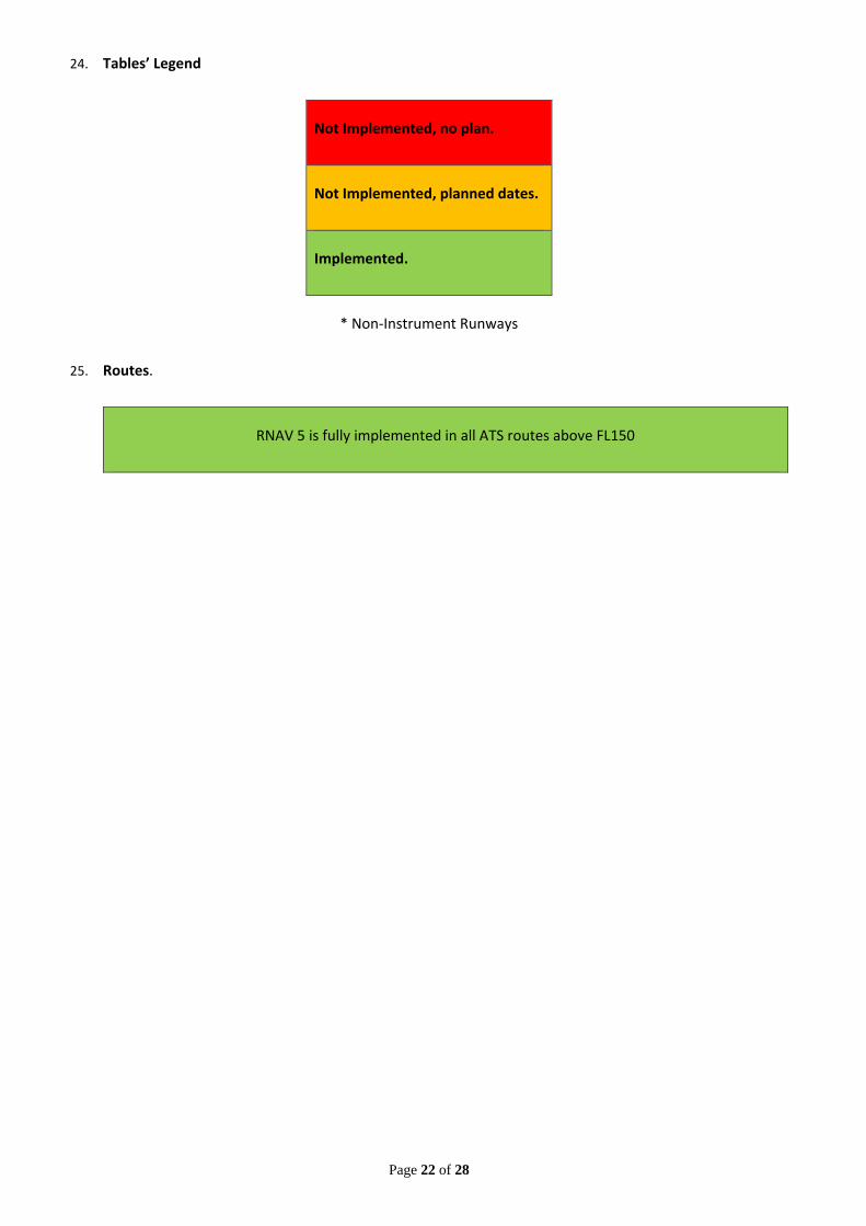
24. Tables’ Legend
Not Implemented, no plan.
Not Implemented, planned dates.
Implemented.
* Non-Instrument Runways
25. Routes.
RNAV 5 is fully implemented in all ATS routes above FL150
Page 23 of 28
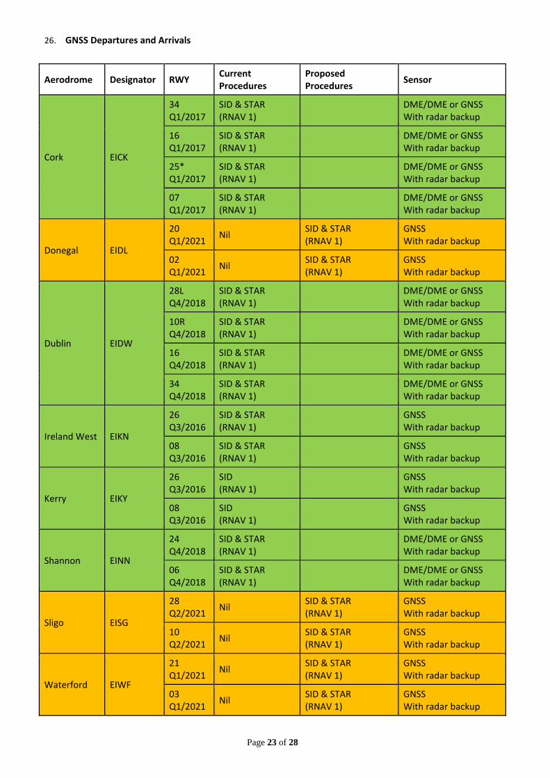
26. GNSS Departures and Arrivals
Aerodrome Designator RWY Current Procedures
Proposed Procedures
Sensor
Cork EICK
34 Q1/2017
SID & STAR (RNAV 1)
DME/DME or GNSS With radar backup
16 Q1/2017
SID & STAR (RNAV 1)
DME/DME or GNSS With radar backup
25* Q1/2017
SID & STAR (RNAV 1)
DME/DME or GNSS With radar backup
07 Q1/2017
SID & STAR (RNAV 1)
DME/DME or GNSS With radar backup
Donegal EIDL
20 Q1/2021
Nil SID & STAR (RNAV 1)
GNSS With radar backup
02 Q1/2021
Nil SID & STAR (RNAV 1)
GNSS With radar backup
Dublin EIDW
28L Q4/2018
SID & STAR (RNAV 1)
DME/DME or GNSS With radar backup
10R Q4/2018
SID & STAR (RNAV 1)
DME/DME or GNSS With radar backup
16 Q4/2018
SID & STAR (RNAV 1)
DME/DME or GNSS With radar backup
34 Q4/2018
SID & STAR (RNAV 1)
DME/DME or GNSS With radar backup
Ireland West EIKN
26 Q3/2016
SID & STAR (RNAV 1)
GNSS With radar backup
08 Q3/2016
SID & STAR (RNAV 1)
GNSS With radar backup
Kerry EIKY
26 Q3/2016
SID (RNAV 1)
GNSS With radar backup
08 Q3/2016
SID (RNAV 1)
GNSS With radar backup
Shannon EINN
24 Q4/2018
SID & STAR (RNAV 1)
DME/DME or GNSS With radar backup
06 Q4/2018
SID & STAR (RNAV 1)
DME/DME or GNSS With radar backup
Sligo EISG
28 Q2/2021
Nil SID & STAR (RNAV 1)
GNSS With radar backup
10 Q2/2021
Nil SID & STAR (RNAV 1)
GNSS With radar backup
Waterford EIWF
21 Q1/2021
Nil SID & STAR (RNAV 1)
GNSS With radar backup
03 Q1/2021
Nil SID & STAR (RNAV 1)
GNSS With radar backup
Page 24 of 28
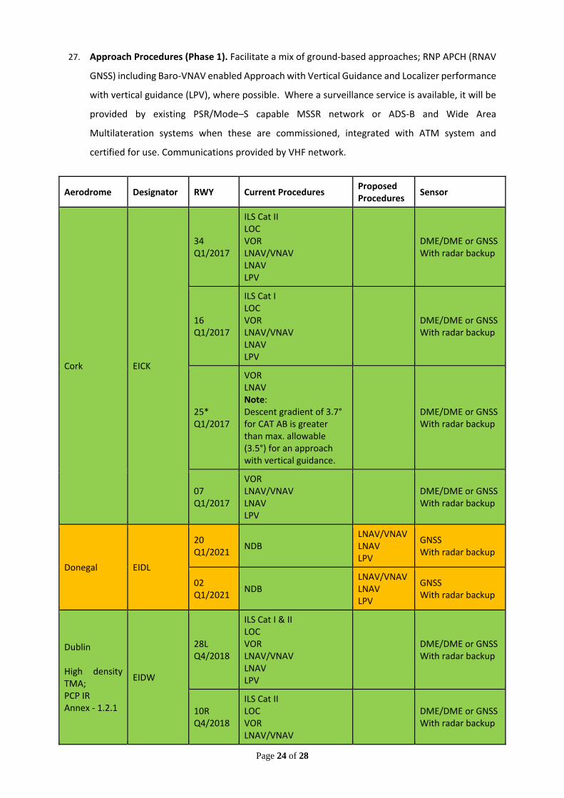
27. Approach Procedures (Phase 1). Facilitate a mix of ground-based approaches; RNP APCH (RNAV
GNSS) including Baro-VNAV enabled Approach with Vertical Guidance and Localizer performance
with vertical guidance (LPV), where possible. Where a surveillance service is available, it will be
provided by existing PSR/Mode–S capable MSSR network or ADS-B and Wide Area
Multilateration systems when these are commissioned, integrated with ATM system and
certified for use. Communications provided by VHF network.
Aerodrome Designator RWY Current Procedures Proposed Procedures
Sensor
Cork EICK
34 Q1/2017
ILS Cat II LOC VOR LNAV/VNAV LNAV LPV
DME/DME or GNSS With radar backup
16 Q1/2017
ILS Cat I LOC VOR LNAV/VNAV LNAV LPV
DME/DME or GNSS With radar backup
25* Q1/2017
VOR LNAV Note: Descent gradient of 3.7° for CAT AB is greater than max. allowable (3.5°) for an approach with vertical guidance.
DME/DME or GNSS With radar backup
07 Q1/2017
VOR LNAV/VNAV LNAV LPV
DME/DME or GNSS With radar backup
Donegal EIDL
20 Q1/2021
NDB LNAV/VNAV LNAV LPV
GNSS With radar backup
02 Q1/2021
NDB LNAV/VNAV LNAV LPV
GNSS With radar backup
Dublin High density TMA; PCP IR Annex - 1.2.1
EIDW
28L Q4/2018
ILS Cat I & II LOC VOR LNAV/VNAV LNAV LPV
DME/DME or GNSS With radar backup
10R Q4/2018
ILS Cat II LOC VOR LNAV/VNAV
DME/DME or GNSS With radar backup

Page 25 of 28
LNAV LPV
16 Q4/2018
ILS Cat II LOC VOR LNAV/VNAV LNAV LPV
DME/DME or GNSS With radar backup
34 Q4/2018
VOR LNAV/VNAV LNAV LPV
DME/DME or GNSS With radar backup
Ireland West EIKN
26 Q1/2021
ILS Cat I & II LOC VOR NDB LNAV/VNAV LNAV
LPV GNSS With radar backup
08 Q1/2021
VOR NDB LNAV/VNAV LNAV
LPV GNSS With radar backup
Kerry EIKY
26 Q1/2021
ILS Cat I LOC NDB LNAV/VNAV LNAV
LPV GNSS With radar backup
08 Q1/2021
NDB LNAV/VNAV LNAV
LPV GNSS With radar backup
Shannon EINN
24 Q1/2021
ILS Cat I & II LOC VOR
LNAV/VNAV LNAV LPV
DME/DME or GNSS With radar backup
06 Q1/2021
ILS Cat I & II LOC VOR
LNAV/VNAV LNAV LPV
DME/DME or GNSS With radar backup
Sligo EISG
28 Q1/2021
LNAV/VNAV LNAV LPV
NDB
GNSS With radar backup
10 Q1/2021
LNAV/VNAV LNAV LPV
NDB
GNSS With radar backup
Waterford EIWF
21 Q3/2021
ILS Cat I LOC NDB
LNAV/VNAV LNAV LPV
GNSS With radar backup
03 Q3/2021
NDB LNAV/VNAV LNAV LPV
GNSS With radar backup
Page 26 of 28
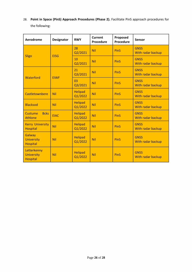
28. Point in Space (PinS) Approach Procedures (Phase 2). Facilitate PinS approach procedures for
the following:
Aerodrome Designator RWY Current Procedure
Proposed Procedure
Sensor
Sligo EISG
28 Q2/2021
Nil PinS GNSS With radar backup
10 Q2/2021
Nil PinS GNSS With radar backup
Waterford EIWF
21 Q3/2021
Nil PinS GNSS With radar backup
03 Q3/2021
Nil PinS GNSS With radar backup
Castletownbere Nil Helipad Q1/2022
Nil PinS GNSS With radar backup
Blacksod Nil Helipad Q1/2022
Nil PinS GNSS With radar backup
Custume Bcks Athlone
EIAC Helipad Q1/2022
Nil PinS GNSS With radar backup
Kerry University Hospital
Nil Helipad Q1/2022
Nil PinS GNSS With radar backup
Galway University Hospital
Nil Helipad Q1/2022
Nil PinS GNSS With radar backup
Letterkenny University Hospital
Nil Helipad Q1/2022
Nil PinS GNSS With radar backup
Page 27 of 28
29. Conclusion. The implementation of PBN in Ireland’s controlled airspace will require the allocation
of significant resources by each of the key industry stakeholders and the Irish Aviation Authority
(IAA). This investment is considered essential to securing the benefits for Ireland at the earliest
opportunity.
29.1 Benefits:
• Safety improvements through greater adherence to a safe flight trajectory (e.g. use
of Continuous Descent Operations (CDO)/Continuous Climb Operations (CCO)
which is a key component of the ICAO strategy to address Controlled Flight into
Terrain (CFIT) accidents).
• Efficiency improvements through changes to air route and approach procedure
designs that minimise the air miles flown and enhance schedule reliability, provide
greater conformance to the flight plan and reduce enroute traffic delays, which will
collectively reduce total operating costs and improve on-time performance.
• Improved environmental performance through greater use of uninterrupted climb
and descent trajectories which ensure that both Green House Gas (GHG) emissions
and the noise footprint for aviation are minimised.
29.2 Ireland’s methodology for the transition to PBN is:
• Maintenance of the present area navigation capability
• Transition to the SES Navigation Strategy
• Introduction of APV capability through barometric vertical navigation
• Development of RNP APCH (to include LPV’s) for all runways as well as RNAV SID’s
& STAR’s
• Non-Precision runways by 03 December 2020 (phase 1) and precision runways by
25 January 2024 (phase 2).
• Utilise the European GNSS as the enabling technology for the implementation of
PBN
• Utilise radar vectoring (the backup system) for all aerodromes.
• Removing by 06 June 2030 (phase 3) of conventional instrument flight procedures
and mixed mode traffic
• Removal of ground based navigational aids by 06 June 2030 (phase 3)
• Installation of GBAS for Dublin

Page 28 of 28
30. Consultation.
30.1 Process. Written consultation was carried out with the key stakeholders as listed below. A
period of one month was given for responses.
30.2 The key stakeholders are:
• Air Navigation Service Providers & Aerodrome Operators
o ATM Operations & Strategy, IAA (EICK, EINN, EIDW)
o daa (EICK, EIDW)
o EIDL
o EIKN
o EIKY
o EIME (Irish Air Corps)
o EISG
o EIWF
o EIWT
o saa
• Aircraft Operators
• IAA SRD / DTTAS
• Network Manager, EuroControl
• Network Manager, ATM Operations & Strategy, IAA
• Airspace users and representative organisations
• Providers of ATM/ANS that provide their services in adjacent airspace blocks (CAA,
UK).