Embed Size (px)
Citation preview
The Project on Integrated UMRT and Urban Development for Hanoi in Vietnam FINAL REPORT PART II
3-10
3.3 Proposed Station Area Development Program and Projects
3.1.1 Overall Development Framework
1) UMRT Station Utilization Framework
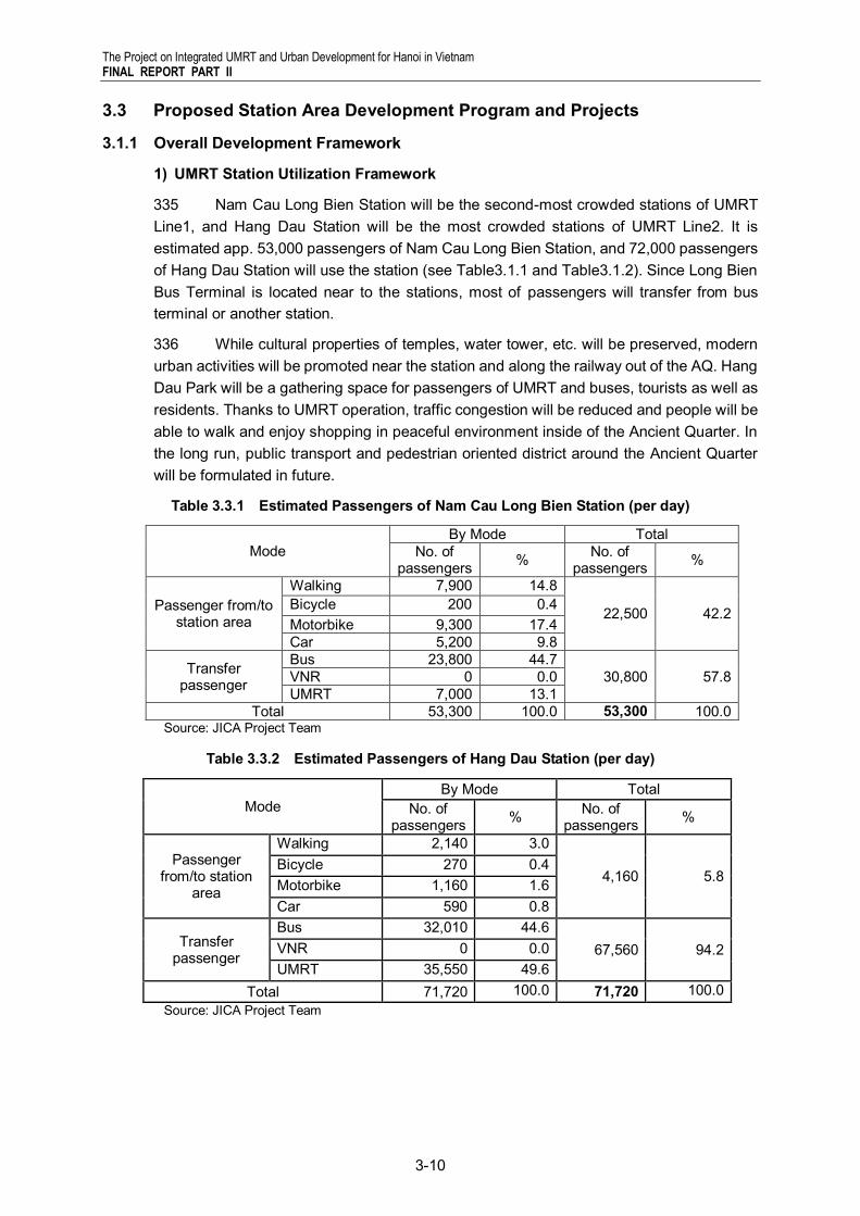
335 Nam Cau Long Bien Station will be the second-most crowded stations of UMRT Line1, and Hang Dau Station will be the most crowded stations of UMRT Line2. It is estimated app. 53,000 passengers of Nam Cau Long Bien Station, and 72,000 passengers of Hang Dau Station will use the station (see Table3.1.1 and Table3.1.2). Since Long Bien Bus Terminal is located near to the stations, most of passengers will transfer from bus terminal or another station.
336 While cultural properties of temples, water tower, etc. will be preserved, modern urban activities will be promoted near the station and along the railway out of the AQ. Hang Dau Park will be a gathering space for passengers of UMRT and buses, tourists as well as residents. Thanks to UMRT operation, traffic congestion will be reduced and people will be able to walk and enjoy shopping in peaceful environment inside of the Ancient Quarter. In the long run, public transport and pedestrian oriented district around the Ancient Quarter will be formulated in future.
Table 3.3.1 Estimated Passengers of Nam Cau Long Bien Station (per day)
Mode By Mode Total
No. of passengers % No. of
passengers %
Passenger from/to station area
Walking 7,900 14.8
22,500 42.2 Bicycle 200 0.4 Motorbike 9,300 17.4 Car 5,200 9.8
Transfer passenger
Bus 23,800 44.7 30,800 57.8 VNR 0 0.0
UMRT 7,000 13.1 Total 53,300 100.0 53,300 100.0
Source: JICA Project Team
Table 3.3.2 Estimated Passengers of Hang Dau Station (per day)
Mode By Mode Total
No. of passengers % No. of
passengers %
Passenger from/to station
area
Walking 2,140 3.0
4,160 5.8 Bicycle 270 0.4 Motorbike 1,160 1.6 Car 590 0.8
Transfer passenger
Bus 32,010 44.6 67,560 94.2 VNR 0 0.0
UMRT 35,550 49.6 Total 71,720 100.0 71,720 100.0
Source: JICA Project Team
The Project on Integrated UMRT and Urban Development for Hanoi in Vietnam FINAL REPORT PART II
3-11
2) Urban Development Framework
337 Urban development will be promoted urban blocks along elevated railway of UMRT Line1. Since it is restricted to change landuse and urban forms of the Ancient Quarter, UMRT development will have a great impact on surrounding area of the AQ. Urban redevelopment along the railway will generate app. 4,500 employees, and high-dense residential areas will be redeveloped and landuse will be converted into mixed-use to accommodate commercial and business facilities and housings.
338 Most of facilities of urban blocks west of Nam Cau Long Bien Station belong to military. So it is necessary to discuss with Ministry of Defense how to utilize new UMRT station and surrounding areas for interests of citizens.
Table 3.3.3 Estimated Population and Employees of Nam Cau Long Bien and Hang Dau Station Area
Whole Station Area (within 500m radius)
Urban development planning area
Present Future Future Area (ha) 78.5 78.5 6.6 Population (persons) 31,374 24,357 3,368 Gross population density (per/ha) 400 310 510 Employment population (persons) 22,350 26,959 3,494
Source: JICA Project Team
3.1.2 Project Formulation
339 Based on the vision and strategies, urban development projects are proposed with taking into consideration of current urban structure and landuse (see Table3.3.4).
Table 3.3.4 Proposed Projects for Nam Cau Long Bien and Hang Dau Station Area Development
Transport Development Strategy Economic Development Strategy Living Condition Improvement Strategy
Station and related facilities
Construction of Nam Cau Long Bien Station
Construction of Hang Dau Station Construction of pedestrian deck
Development of commercial and public facilities inside of station
Develop public service facilities inside of station
Within 100m Development of new trunk road between Hang Dau Street and Yen Phu Street
Development station access plaza Pedestrian underground development
Development of Underground parking of Hang Dau Park (planned)
Underground mall development Development of commercial facilities around station access plaza
Redevelopment of Hang Dau Park
Development of Water Tower Park
Within 500m Widening of Phung Hung Street Construction of mixed-use commercial and business buildings
Development of cultural and public buildings
Construction of mixed-use residential buildings
Surrounding influenced area
Traffic management of Ancient Quarter
Revitalization of traditional commercial streets of the AQ
Improvement of housings and urban infrastructure of the AQ
Source: JICA Project Team
The Project on Integrated UMRT and Urban Development for Hanoi in Vietnam FINAL REPORT PART II
3-12
340 Based on proposed projects above, future landuse plan and projects are formulated as follows (see Table3.3.5 and Table3.3.6):
Table 3.3.5 Future Landuse Plan of Nam Cau Long Bien and Hang Dau Station Area
Residential Mixed use
Commercial and
Business
Special public use
Transport Green and openspace Military Road Total
ha 0.0 4.1 1.1 0.0 0.6 0.9 0.0 1.4 8.1 % 0.0 50.6 13.6 0.0 7.4 11.1 0.0 17.3 100.0
Source: JICA Project Team
Table 3.3.6 List of Project Packages for Nam Cau Long Bien and Hang Dau Station Area Development
Project Type Name of Project Project ID
Scale (ha) Schedule Landuse
Station and related facility development
Nam Cau Long Bien Station S1 0.6 Minimum Transport Hang Dau Station (underground)1) S2 - Minimum Transport Pedestrian deck between Nam Cau Long Bien Station and Long Bien Bus Terminal
S3 - Minimum Transport
Station access plaza development S4 0.2 Short Transport Road development
New trunk road development under elevated railway (w=24m, l=371m) R1 0.9 Minimum Transport
Widening of Phung Hung Street (w=28m, l=680m) R2 - Minimum Transport
Urban development
Urban redevelopment of Nguyen Trung Truc Commune A 4.4 Short Mixed use
Urban redevelopment of west Nam Cau Long Bien Station B 1.1 Medium C&B
Green and openspace
development Hang Dau Park and Water Tower Park development G1 0.9 Short Green& Openspace
Total Project Area 8.1 1) Underground station development includes pedestrian underground development. Source: JICA Project Team
The Project on Integrated UMRT and Urban Development for Hanoi in Vietnam FINAL REPORT PART II
3-13
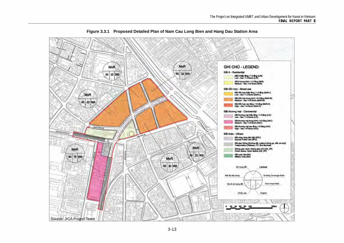
Figure 3.3.1 Proposed Detailed Plan of Nam Cau Long Bien and Hang Dau Station Area
Source: JICA Project Team
The Project on Integrated UMRT and Urban Development for Hanoi in Vietnam FINAL REPORT PART II
3-14
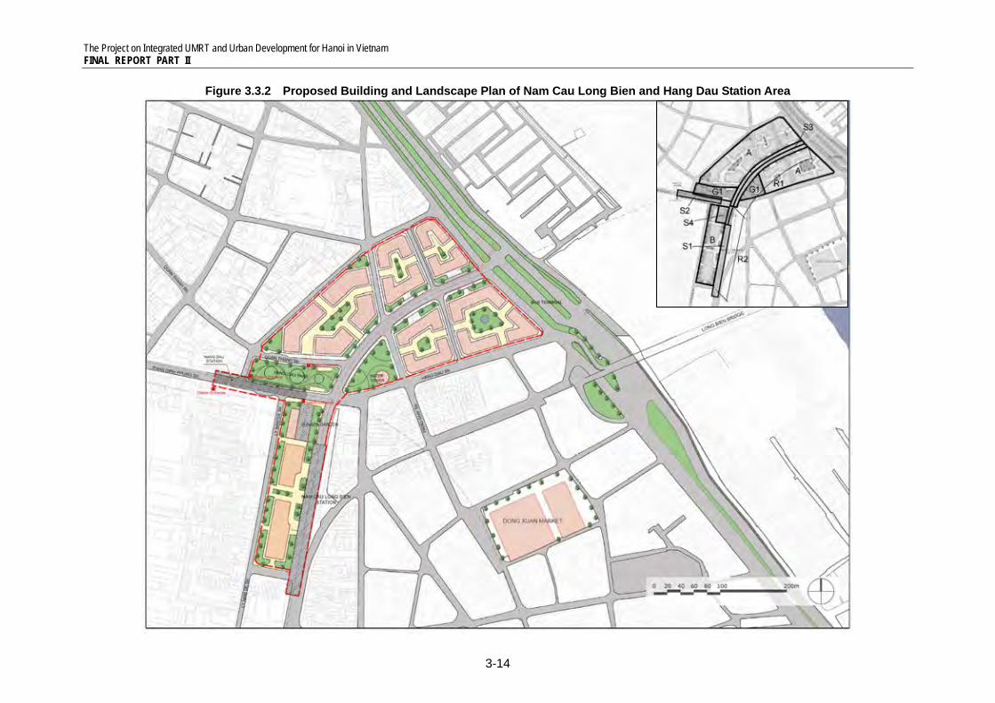
Figure 3.3.2 Proposed Building and Landscape Plan of Nam Cau Long Bien and Hang Dau Station Area
The Project on Integrated UMRT and Urban Development for Hanoi in Vietnam FINAL REPORT PART II
3-15
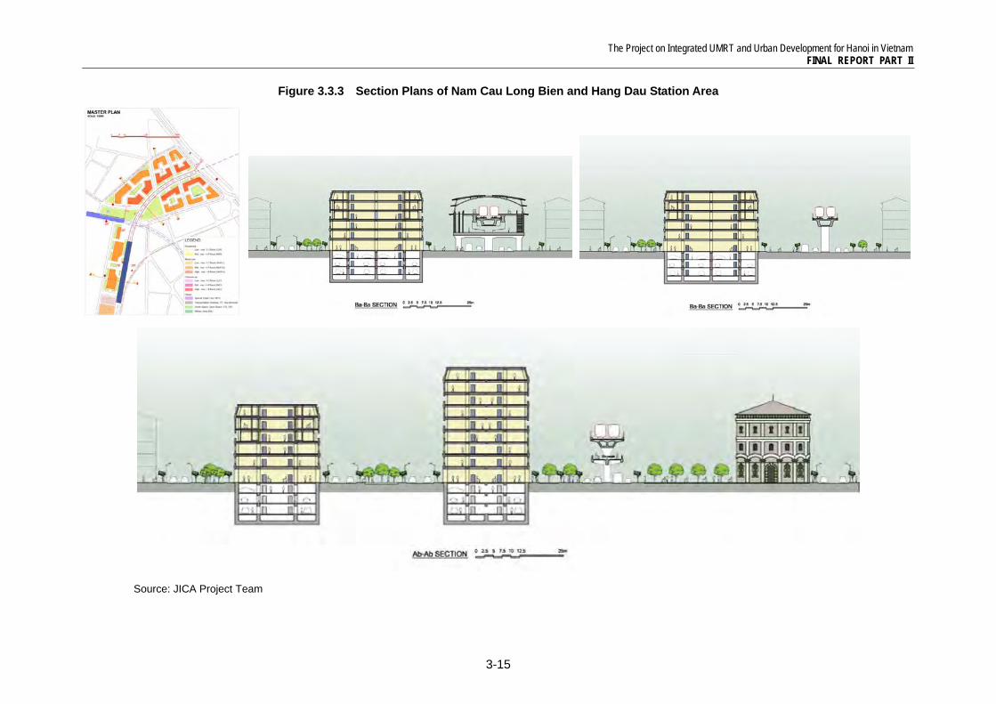
Figure 3.3.3 Section Plans of Nam Cau Long Bien and Hang Dau Station Area
Source: JICA Project Team
The Project on Integrated UMRT and Urban Development for Hanoi in Vietnam FINAL REPORT PART II
3-16
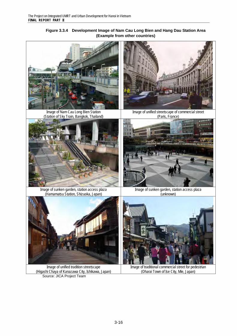
Figure 3.3.4 Development Image of Nam Cau Long Bien and Hang Dau Station Area (Example from other countries)
Image of Nam Cau Long Bien Station
(Station of Sky Train, Bangkok, Thailand) Image of unified streetscape of commercial street
(Paris, France)
Image of sunken garden, station access plaza
(Hamamatsu Station, Shizuoka, Japan) Image of sunken garden, station access plaza
(unknown)
Image of unified tradition streetscape
(Higashi Chaya of Kanazawa City, Ishikawa, Japan) Image of traditional commercial street for pedestrian
(Oharai Town of Ise City, Mie, Japan) Source: JICA Project Team
The Project on Integrated UMRT and Urban Development for Hanoi in Vietnam FINAL REPORT PART II
3-17
3.1.3 Station and Related Facilities Development Plan (Project S1, S2 and S3)
341 Nam Cau Long Bien Station Facility: Nam Cau Long Bien Station of elevated UMRT Line1 will be located north-west of the Ancient Quarter, along Phung Hung Street. The space under the elevated station, it will be utilized as pedestrian space and bus stops. From the platform of 3rd floor, passengers will be able to enjoy scenery of the Ancient Quarter.
342 Hang Dau Station Facility: Hang Dau Station of underground UMRT Line2 will be located south of Hang Dau Park, under Phan Dinh Phung Street. Since this station is located near the park area, it is necessary to propose mitigation measures of negative environmental impacts, and to plan appropriate locations and designs of entrances and facilities which will be harmonized with the park.
343 Pedestrian Deck: From the concourse of 2nd floor of Nam Cau Long Bien Station, skywalk will be developed under the viaduct to connect to Hang Dau Park and Long Bien Bus Terminal, so bus passengers will be able to cross the intersection and access directly to two stations.
344 Station Access Plaza: One of the issues is how to improve transfer accessibility between two stations, since i) it is expected more than half of passengers transfer from another station, and ii) there is a big vertical interval (app. 30m) between platforms of two stations. In addition, it has not been clarified which agency is responsible to plan and develop these transfer facilities of two lines. To improve transfer accessibility of two stations, station access plaza with sunken garden, shopping mall and openspace with pedestrian underground, elevator and escalator will be developed to connect two stations. Passengers can transfer two lines keeping out of sunshine and rain, and enjoy shopping and relaxing during commuting time.
The Project on Integrated UMRT and Urban Development for Hanoi in Vietnam FINAL REPORT PART II
3-18
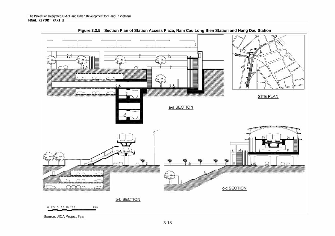
Figure 3.3.5 Section Plan of Station Access Plaza, Nam Cau Long Bien Station and Hang Dau Station
Source: JICA Project Team
The Project on Integrated UMRT and Urban Development for Hanoi in Vietnam FINAL REPORT PART II
3-19
3.1.4 Road Development Plan (Project R1 and R2)
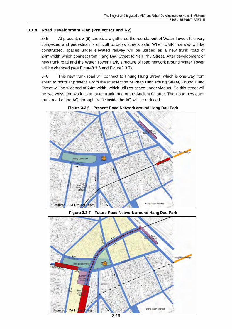
345 At present, six (6) streets are gathered the roundabout of Water Tower. It is very congested and pedestrian is difficult to cross streets safe. When UMRT railway will be constructed, spaces under elevated railway will be utilized as a new trunk road of 24m-width which connect from Hang Dau Street to Yen Phu Street. After development of new trunk road and the Water Tower Park, structure of road network around Water Tower will be changed (see Figure3.3.6 and Figure3.3.7).
346 This new trunk road will connect to Phung Hung Street, which is one-way from south to north at present. From the intersection of Phan Dinh Phung Street, Phung Hung Street will be widened of 24m-width, which utilizes space under viaduct. So this street will be two-ways and work as an outer trunk road of the Ancient Quarter. Thanks to new outer trunk road of the AQ, through traffic inside the AQ will be reduced.
Figure 3.3.6 Present Road Network around Hang Dau Park
Figure 3.3.7 Future Road Network around Hang Dau Park
Source: JICA Project Team
Source: JICA Project Team
The Project on Integrated UMRT and Urban Development for Hanoi in Vietnam FINAL REPORT PART II
3-20
3.1.5 Urban Development Plan of Nguyen Trung Truc Commune (Project A)
(1) Present Condition
347 Nguyen Trung Truc Commune is high-dense residential area (543persons/ha), which is situated just next to the north of the Ancient Quarter and close to Long Bien Station of National Railway and Long Bien Bus Terminal. There are a few better-known hotels in the commune and the location is quite convenient for tourists because of closeness to Ancient Quarter and West Lake. There are public facilities such as schools, hospitals, local markets and temples which foster community atmosphere of this commune.
348 When UMRT will be developed, some housings and facilities need to be relocated. In addition, construction of a new trunk road will have many impacts on this commune from social, economical, physical, and environmental aspects. While the Ancient Quarter is a special district as a cultural property of Vietnam and need to be preserved, urban development activities will be promoted districts nearby UMRT railway as an integrated urban development.
(2) Proposed Functions and Facilities
349 The Block A have a big potential to develop new modern urban facilities in distinction from traditional commercial activities in the AQ. Existing urban facilities in the block such as school, hospital, etc. will be move into new urban facilities.
350 The elevated UMRT railway and a new trunk road will formulate very modern townscape. Along the new road, mid-rise buildings of 8th floor will be constructed with 10m setback to create an urban axis with modern infrastructure. Commercial and business facilities of 1st and 2nd floors will be gathered to create a new fashionable street, and there are residential complex from 3rd and above floors.
351 The blocks behind, mid-rise buildings of 5th floor will be developed. Between buildings along the railway and behind, a pedestrian street will be developed in parallel with the new trunk road. This street will be utilized as an openspace, an event space, a shopping street for residents and employees to promote daily activities for local communities.
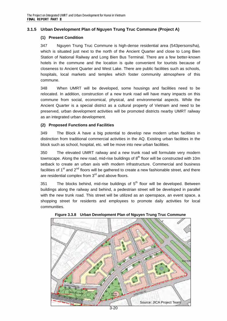
Figure 3.3.8 Urban Development Plan of Nguyen Trung Truc Commune
Source: JICA Project Team
The Project on Integrated UMRT and Urban Development for Hanoi in Vietnam FINAL REPORT PART II
3-21
3.1.6 Urban Redevelopment of West Nam Cau Long Bien Station (Project B)
(1) Present Condition
352 The block D is enclosed by Phan Dinh Phung Street of north, Le Van Linh Street of south, Phung Hung Street of east, and Ly Nam De Street of west. In this block, there are military-related facilities, such as a newspaper company, a cinema, residential buildings, etc. Along Ly Nam De Street whish Ministry of Defense is located west side, many computer shops can be found, and community entrance gates can be found which leads to inner courtyard surrounded by houses. Along Phung Hung Street, there is a local market.
353 Though this area is very convenient to access to the Ancient Quarter and West Lake, present urban functions are not appropriate which is not open to public. When Nam Cau Long Bien Station will be constructed, many passengers will gather to use UMRT railway.
(2) Proposed Functions and Facilities
354 To maximize land potential which Nam Cau Long Bien Station is located east side, commercial facilities will be developed in long-term. Since there are many passengers who transfer two railways, business opportunities are high, and passengers will feel convenient to use these stations. Inside the facilities, restaurants and cafes, tourist center, computer service shop, etc. will be promoted which are harmonized with traditional commercial activities of the Ancient Quarter.
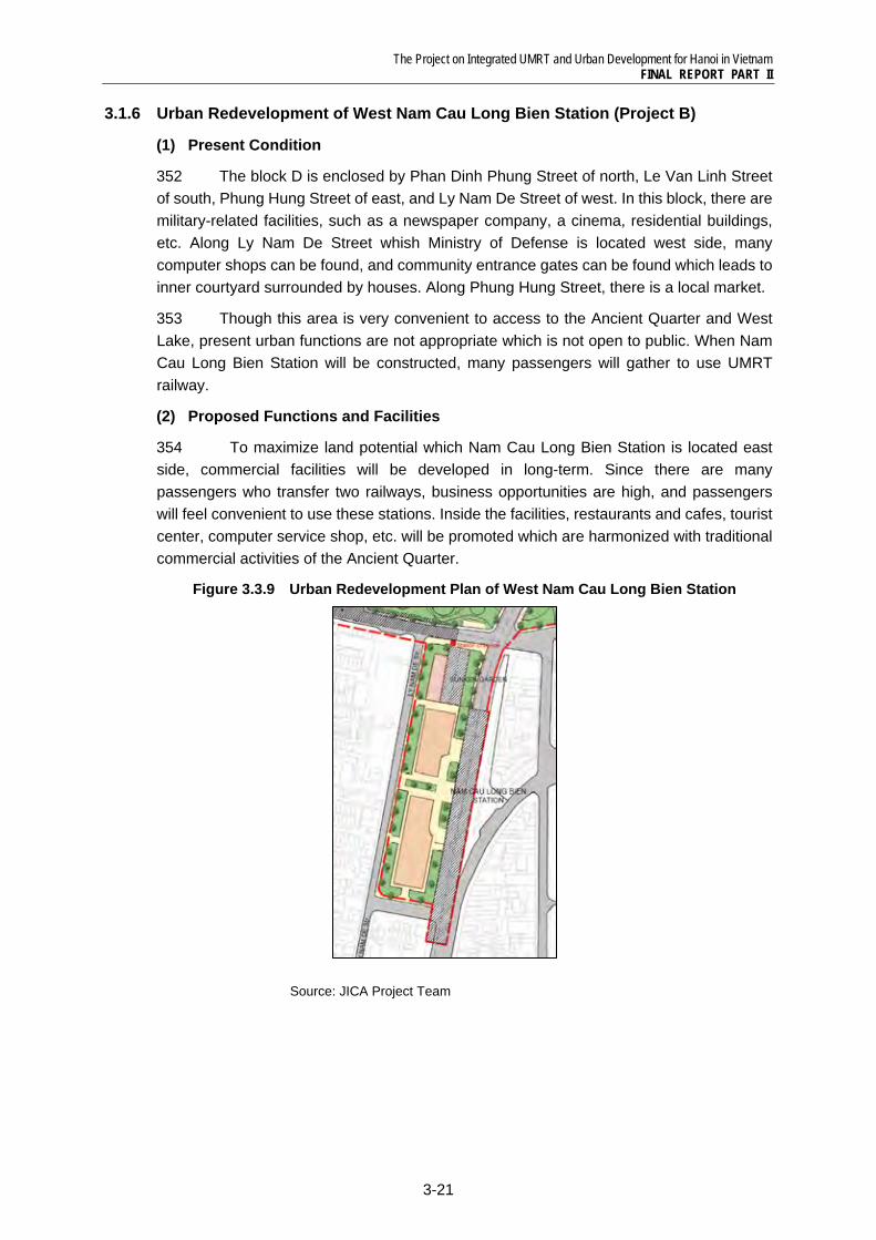
Figure 3.3.9 Urban Redevelopment Plan of West Nam Cau Long Bien Station
Source: JICA Project Team
The Project on Integrated UMRT and Urban Development for Hanoi in Vietnam FINAL REPORT PART II
3-22
3.1.7 Hang Dau Park and Water Tower Park Development (Project G1 and G2)
(1) Present Condition
355 Water Tower was built in 1904, which has three layers with different architectural style thus important historical heritage as well as landmark in this area. Hang Dau Park is west of the Water Tower, between Quan Thanh Street which is one-way from east to west, and Phang Dinh Phong Street which is one-way from west to east. These properties are precious in a high-dense area to create a space with amenity and cultural atmosphere.
356 Hang Dau Park is popular for local community to provide multi-purpose openspace to relax, enjoy exercise, open a market, etc. It is planned to develop underground car parking facility under the Hang Dau Park.
357 On the contrary, there is only narrow sidewalk and public toilet, but no openspace around the Water Tower, so it is just like a central tower of the roundabout.
(2) Proposed Functions and Facilities
358 Hang Dau Park will be redeveloped together when Hang Dau Station and underground car parking facility will be constructed. This park will be a main entrance to the subway station and parking. Since two streets of north and south of the park are main trunk roads to connect West Lake and Ba Dinh District, bus passengers will access from these streets. Bus stops will be developed which is harmonized with the park.
359 Because of reorganization of road network around the Water Tower, enough openspace will be secured around the tower. It is planned that the Water Tower will be renovated as a museum of water system. It is recommended to exhibit environmental and ecological system of river and lake of Hanoi City, with historical change of the Ancient Quarter. The Water Tower Park will be a symbolic area as an ecological museum.
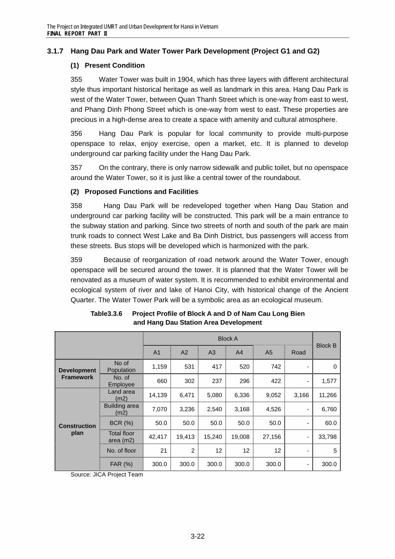
Table3.3.6 Project Profile of Block A and D of Nam Cau Long Bien and Hang Dau Station Area Development
Block A
Block BA1 A2 A3 A4 A5 Road
Development Framework
No of Population 1,159 531 417 520 742 - 0
No. of Employee 660 302 237 296 422 - 1,577
Construction plan
Land area (m2) 14,139 6,471 5,080 6,336 9,052 3,166 11,266
Building area (m2) 7,070 3,236 2,540 3,168 4,526 - 6,760
BCR (%) 50.0 50.0 50.0 50.0 50.0 - 60.0
Total floor area (m2) 42,417 19,413 15,240 19,008 27,156 - 33,798
No. of floor 21 2 12 12 12 - 5
FAR (%) 300.0 300.0 300.0 300.0 300.0 - 300.0
Source: JICA Project Team
The Project on Integrated UMRT and Urban Development for Hanoi in Vietnam FINAL REPORT PART II
3-23
3.4 Social and Environmental Considerations
3.4.1 Current state of socio-environmental condition
360 The proposed stations are located in the west of the existing Long Bien Station, near the Hang Dau Flower Park. The Ancient Quarter is located just in the east of the proposed stations. Areas surrounding the planned stations are densely populated with many offices, stores, houses, hospitals, hotels, etc. Traffic flows on Phan Dinh Phung Street and Hang Dau Street in the north of the proposed station are usually heavy. According to an environmental survey in 2006, noise levels around the station are exceeding the allowable maximum limits, and concentration of NO2 (190µg/m3) in ambient air has almost reached the maximum allowable level (200µg/m3).
Table3.4.1 Condition of Ambient Air Temper-
ature Humidity Dust CO SO2 NO2 HC
(°C) (%) (µg/m3) (µg/m3) (µg/m3) (µg/m3) (µg/m3) 24.1 74.7 110 12510 230 190 70
29.4 78 82 617 186 132 226
Table3.4.2 Condition of Ambient Air Noise (day time: 6-18h) Noise (night time: 18-22h) Vibration
Leq Lamax L50 Leq Lamax L50 Laeq Lv (dB) (dB) (dB) (dB) (dB) (dB) (m/s2) (mm/s)
70.3 79.5 68.8 66.1 74.7 65.1 na na
73 84.3 68.8 64.6 76.6 60 0.0045 0.0016 Note: HC: Hazardous substances in ambient air
Air quality, noise, and vibration survey carried out by CEPT, in December 2006 (for the first line in the table), and in May-June 2007 (for the second line in the table) Allowable maximum limit: Dust 300µg/m3, CO 30,000µg/m3, SO2 350µg/m3, NO2 200µg/m3, HC 5,000µg/m3, Noise day time Leq 60dB, Noise night time Leq 55dB, Vibration Leq 0.030m/s2
Source: EIA Report 2007, CEPT
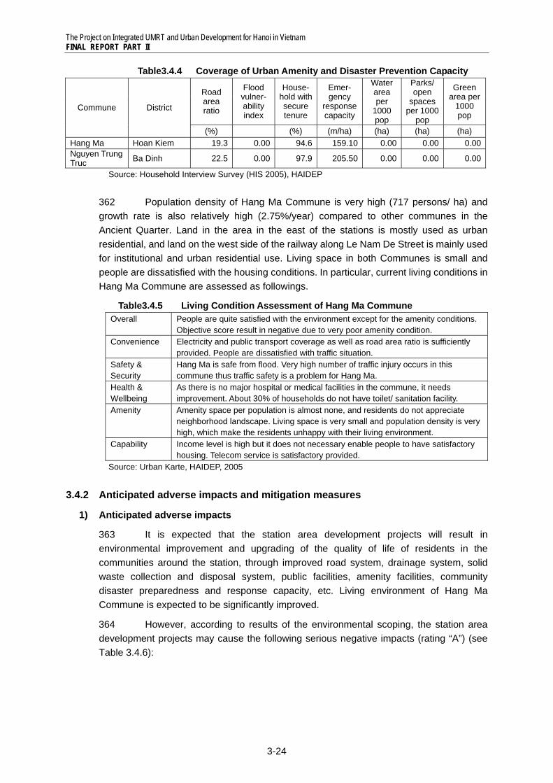
361 The station area development projects will cause impacts mostly to communities of Hang Ma Commune and Nguyen Trung Truc Commune. In Hang Ma Commune, piped water connectivity (97.3%) and toilet coverage (70.6%) are relatively low. In addition, both Communes are in severe lack of water area, park/open space, and green area.
Table3.4.3 Coverage of Public Service and Sanitation
Commune District Electri-
city
Piped water con-
nectivity
Toilet cover- age
Gas Tele- phone
Solid waste collec-
tion
Internet
(%) (%) (%) (%) (%) (%) (%) Hang Ma Hoan Kiem 100.0 97.3 70.6 81.3 91.2 97.3 13.5Nguyen Trung Truc Ba Dinh 100.0 100.0 87.2 83.0 95.7 100.0 8.7
Source: Household Interview Survey (HIS 2005), HAIDEP
The Project on Integrated UMRT and Urban Development for Hanoi in Vietnam FINAL REPORT PART II
3-24
Table3.4.4 Coverage of Urban Amenity and Disaster Prevention Capacity
Commune District
Road area ratio
Flood vulner- ability index
House- hold with secure tenure
Emer- gency
response capacity
Water area per
1000 pop
Parks/ open
spaces per 1000
pop
Green area per
1000 pop
(%) (%) (m/ha) (ha) (ha) (ha) Hang Ma Hoan Kiem 19.3 0.00 94.6 159.10 0.00 0.00 0.00Nguyen Trung Truc Ba Dinh 22.5 0.00 97.9 205.50 0.00 0.00 0.00
Source: Household Interview Survey (HIS 2005), HAIDEP
362 Population density of Hang Ma Commune is very high (717 persons/ ha) and growth rate is also relatively high (2.75%/year) compared to other communes in the Ancient Quarter. Land in the area in the east of the stations is mostly used as urban residential, and land on the west side of the railway along Le Nam De Street is mainly used for institutional and urban residential use. Living space in both Communes is small and people are dissatisfied with the housing conditions. In particular, current living conditions in Hang Ma Commune are assessed as followings.
Table3.4.5 Living Condition Assessment of Hang Ma Commune Overall People are quite satisfied with the environment except for the amenity conditions.
Objective score result in negative due to very poor amenity condition. Convenience Electricity and public transport coverage as well as road area ratio is sufficiently
provided. People are dissatisfied with traffic situation. Safety & Security
Hang Ma is safe from flood. Very high number of traffic injury occurs in this commune thus traffic safety is a problem for Hang Ma.
Health & Wellbeing
As there is no major hospital or medical facilities in the commune, it needs improvement. About 30% of households do not have toilet/ sanitation facility.
Amenity Amenity space per population is almost none, and residents do not appreciate neighborhood landscape. Living space is very small and population density is very high, which make the residents unhappy with their living environment.
Capability Income level is high but it does not necessary enable people to have satisfactory housing. Telecom service is satisfactory provided.
Source: Urban Karte, HAIDEP, 2005
3.4.2 Anticipated adverse impacts and mitigation measures
1) Anticipated adverse impacts
363 It is expected that the station area development projects will result in environmental improvement and upgrading of the quality of life of residents in the communities around the station, through improved road system, drainage system, solid waste collection and disposal system, public facilities, amenity facilities, community disaster preparedness and response capacity, etc. Living environment of Hang Ma Commune is expected to be significantly improved.
364 However, according to results of the environmental scoping, the station area development projects may cause the following serious negative impacts (rating “A”) (see Table 3.4.6):
The Project on Integrated UMRT and Urban Development for Hanoi in Vietnam FINAL REPORT PART II
3-25
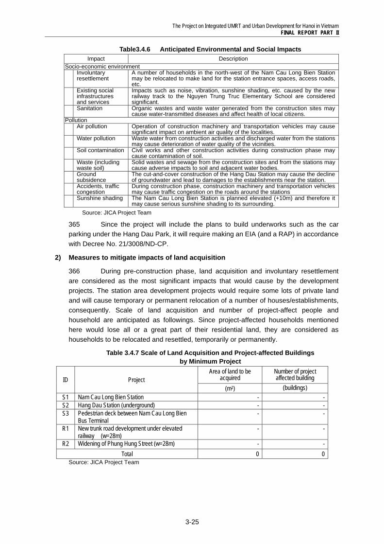
Table3.4.6 Anticipated Environmental and Social Impacts Impact Description
Socio-economic environment Involuntary
resettlement A number of households in the north-west of the Nam Cau Long Bien Stationmay be relocated to make land for the station entrance spaces, access roads, etc.
Existing social infrastructures and services
Impacts such as noise, vibration, sunshine shading, etc. caused by the new railway track to the Nguyen Trung Truc Elementary School are considered significant.
Sanitation Organic wastes and waste water generated from the construction sites may cause water-transmitted diseases and affect health of local citizens.
Pollution Air pollution Operation of construction machinery and transportation vehicles may cause
significant impact on ambient air quality of the localities. Water pollution Waste water from construction activities and discharged water from the stations
may cause deterioration of water quality of the vicinities. Soil contamination Civil works and other construction activities during construction phase may
cause contamination of soil. Waste (including
waste soil) Solid wastes and sewage from the construction sites and from the stations may cause adverse impacts to soil and adjacent water bodies.
Ground subsidence
The cut-and-cover construction of the Hang Dau Station may cause the decline of groundwater and lead to damages to the establishments near the station.
Accidents, traffic congestion
During construction phase, construction machinery and transportation vehiclesmay cause traffic congestion on the roads around the stations
Sunshine shading The Nam Cau Long Bien Station is planned elevated (+10m) and therefore it may cause serious sunshine shading to its surrounding.
Source: JICA Project Team
365 Since the project will include the plans to build underworks such as the car parking under the Hang Dau Park, it will require making an EIA (and a RAP) in accordance with Decree No. 21/3008/ND-CP.
2) Measures to mitigate impacts of land acquisition
366 During pre-construction phase, land acquisition and involuntary resettlement are considered as the most significant impacts that would cause by the development projects. The station area development projects would require some lots of private land and will cause temporary or permanent relocation of a number of houses/establishments, consequently. Scale of land acquisition and number of project-affect people and household are anticipated as followings. Since project-affected households mentioned here would lose all or a great part of their residential land, they are considered as households to be relocated and resettled, temporarily or permanently.
Table 3.4.7 Scale of Land Acquisition and Project-affected Buildings by Minimum Project
ID Project Area of land to be
acquired Number of project affected building
(m2) (buildings) S1 Nam Cau Long Bien Station - - S2 Hang Dau Station (underground) - - S3 Pedestrian deck between Nam Cau Long Bien
Bus Terminal - -
R1 New trunk road development under elevated railway (w=28m)
- -
R2 Widening of Phung Hung Street (w=28m) - - Total 0 0
Source: JICA Project Team
The Project on Integrated UMRT and Urban Development for Hanoi in Vietnam FINAL REPORT PART II
3-26
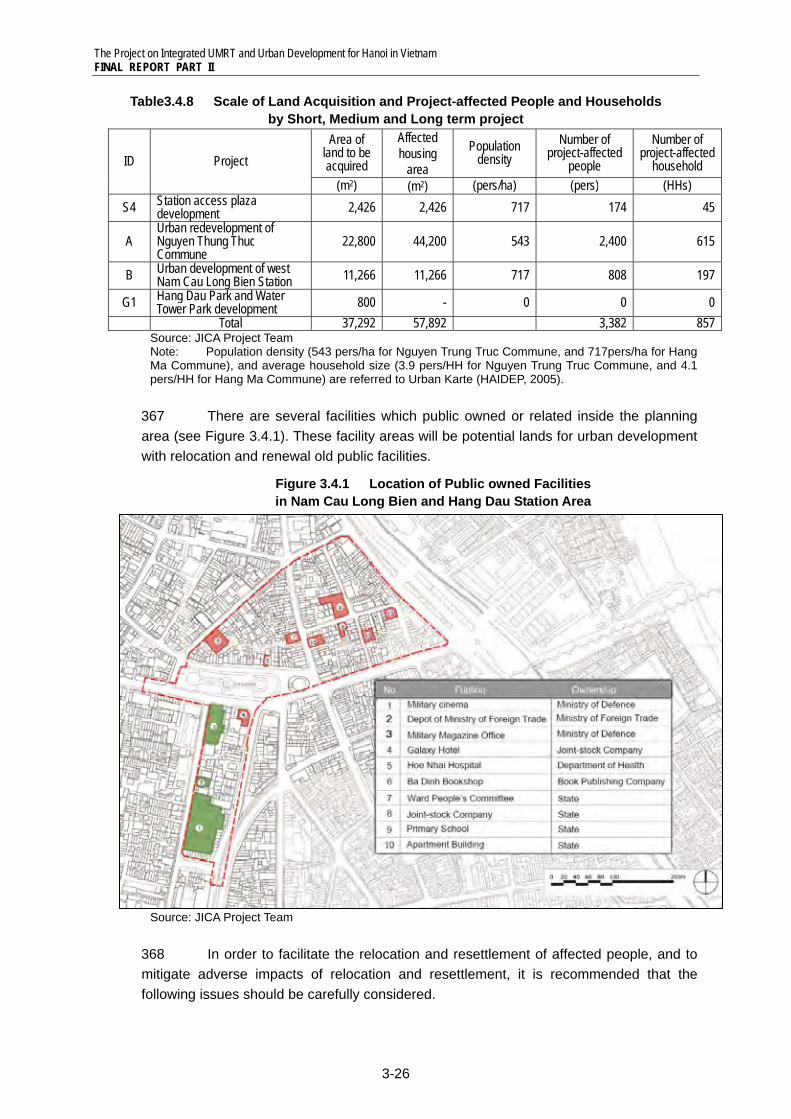
Table3.4.8 Scale of Land Acquisition and Project-affected People and Households by Short, Medium and Long term project
ID Project Area of
land to be acquired
Affected housing
area
Population density
Number of project-affected
people
Number of project-affected
household (m2) (m2) (pers/ha) (pers) (HHs)
S4 Station access plaza development 2,426 2,426 717 174 45
A Urban redevelopment of Nguyen Thung Thuc Commune
22,800 44,200 543 2,400 615
B Urban development of west Nam Cau Long Bien Station 11,266 11,266 717 808 197
G1 Hang Dau Park and Water Tower Park development 800 - 0 0 0
Total 37,292 57,892 3,382 857 Source: JICA Project Team Note: Population density (543 pers/ha for Nguyen Trung Truc Commune, and 717pers/ha for Hang Ma Commune), and average household size (3.9 pers/HH for Nguyen Trung Truc Commune, and 4.1 pers/HH for Hang Ma Commune) are referred to Urban Karte (HAIDEP, 2005).
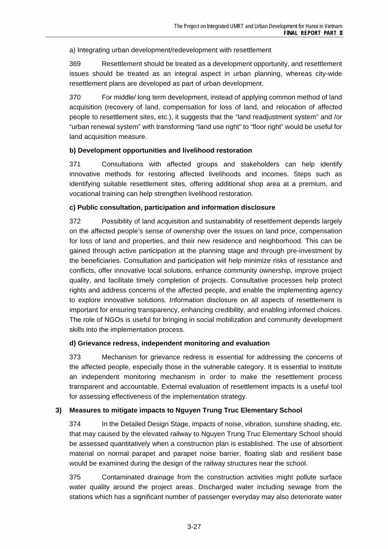
367 There are several facilities which public owned or related inside the planning area (see Figure 3.4.1). These facility areas will be potential lands for urban development with relocation and renewal old public facilities.
Figure 3.4.1 Location of Public owned Facilities in Nam Cau Long Bien and Hang Dau Station Area
Source: JICA Project Team
368 In order to facilitate the relocation and resettlement of affected people, and to mitigate adverse impacts of relocation and resettlement, it is recommended that the following issues should be carefully considered.
The Project on Integrated UMRT and Urban Development for Hanoi in Vietnam FINAL REPORT PART II
3-27
a) Integrating urban development/redevelopment with resettlement
369 Resettlement should be treated as a development opportunity, and resettlement issues should be treated as an integral aspect in urban planning, whereas city-wide resettlement plans are developed as part of urban development.
370 For middle/ long term development, instead of applying common method of land acquisition (recovery of land, compensation for loss of land, and relocation of affected people to resettlement sites, etc.), it suggests that the “land readjustment system” and /or “urban renewal system” with transforming “land use right” to “floor right” would be useful for land acquisition measure.
b) Development opportunities and livelihood restoration
371 Consultations with affected groups and stakeholders can help identify innovative methods for restoring affected livelihoods and incomes. Steps such as identifying suitable resettlement sites, offering additional shop area at a premium, and vocational training can help strengthen livelihood restoration.
c) Public consultation, participation and information disclosure
372 Possibility of land acquisition and sustainability of resettlement depends largely on the affected people’s sense of ownership over the issues on land price, compensation for loss of land and properties, and their new residence and neighborhood. This can be gained through active participation at the planning stage and through pre-investment by the beneficiaries. Consultation and participation will help minimize risks of resistance and conflicts, offer innovative local solutions, enhance community ownership, improve project quality, and facilitate timely completion of projects. Consultative processes help protect rights and address concerns of the affected people, and enable the implementing agency to explore innovative solutions. Information disclosure on all aspects of resettlement is important for ensuring transparency, enhancing credibility, and enabling informed choices. The role of NGOs is useful for bringing in social mobilization and community development skills into the implementation process.
d) Grievance redress, independent monitoring and evaluation
373 Mechanism for grievance redress is essential for addressing the concerns of the affected people, especially those in the vulnerable category. It is essential to institute an independent monitoring mechanism in order to make the resettlement process transparent and accountable. External evaluation of resettlement impacts is a useful tool for assessing effectiveness of the implementation strategy.
3) Measures to mitigate impacts to Nguyen Trung Truc Elementary School
374 In the Detailed Design Stage, impacts of noise, vibration, sunshine shading, etc. that may caused by the elevated railway to Nguyen Trung Truc Elementary School should be assessed quantitatively when a construction plan is established. The use of absorbent material on normal parapet and parapet noise barrier, floating slab and resilient base would be examined during the design of the railway structures near the school.
375 Contaminated drainage from the construction activities might pollute surface water quality around the project areas. Discharged water including sewage from the stations which has a significant number of passenger everyday may also deteriorate water
The Project on Integrated UMRT and Urban Development for Hanoi in Vietnam FINAL REPORT PART II
3-28
quality. The drainage systems at the stations should be properly designed and maintained. In addition, it also needs to design the sewage facilities with a proper capacity, sewage pipes locating lower than the water supply pipes, and if necessary, preliminary treatment facilities. Discharged water quality from stations and surface and groundwater quality should also be monitored.
4) Measures to mitigate impacts of air pollution
376 Residents living in the area around the stations would be affected by air pollution and water pollution cause during construction phase.
377 During construction phase, the operation of construction machinery affects the ambient air quality by emitting pollutants. The magnitude of pollution will depend on the types of equipment and the operation time. Depending on wind conditions such as velocity and direction, emissions from construction equipment would affect the ambient air quality of neighboring areas. In addition, earth moving equipment during construction would also be a major source of dust emission. To mitigate impacts of air pollution, the following measures are recommended.
Periodically cleaning and watering the project sites. Secure distance between the construction machinery and construction site boundary
as much as possible. Using construction equipment and vehicles which comply with the latest regulations. Periodical inspection and maintenance of construction equipment and vehicles. De-concentrate construction activities. De-concentrate the flow of construction trucks. Use cover sheets for trucks carrying soil. Under the weather conditions such as strong wind, the construction activities are
suspended temporally for prevention of dust scattering. Training construction equipment drivers and truck drivers. Monitoring the air quality at the project site during all of the project cycles.
5) Measures to mitigate impacts of water pollution
378 During construction phase, if the contaminated drainage from the construction activities flows into surface water without proper treatment, it would pollute surface water quality around the project areas. During operation phase, discharged water including sewage from the station would deteriorate water quality as well. The following treatment measures should be prepared for discharged water from the project.
Build a small dike to prevent run-off water from construction sites. Consideration of separating construction areas with sheet piles. Mud should be dehydrated before discharged and reused as much as possible. Proper design and maintenance of drainage systems at station. The design includes a
sewage facility with a proper capacity, sewage pipes locating lower than the water supply pipes, and if necessary, preliminary treatment facilities.
Monitoring discharged water quality from stations, and surface water quality.
6) Measures to mitigate impacts of ground subsidence
379 Ground subsidence is also considered as a potential adverse impact that may occur during construction of the underground facilities. The excessive pumping or leakage of groundwater when constructing the underground facilities with the cut-and-cover
The Project on Integrated UMRT and Urban Development for Hanoi in Vietnam FINAL REPORT PART II
3-29
method, would lead to the decrease of pressure of groundwater, ground contracted, and then cause ground subsidence. The ground subsidence damages surrounding establishments by cracks, subsidence and inclination of establishments. Therefore, the following tasks should be carefully considered to mitigate impacts of ground subsidence.
Design of the underground facilities should be carefully conducted based on the detailed survey of geological and groundwater conditions.
Water proof hard retaining wall should be used at construction sites of underground station and underground facilities.
Ensure temporary support at the appropriate time and construction sites. Monitor the groundwater level and leak of groundwater surrounding the underground
facilities. Monitor the level of land subsidence and conditions of sensitive establishments
around the construction sites.
7) Measures to mitigate impacts of soil contamination
380 The construction of underground facilities, such as Hang Dau Station, underground parking of Hang Dau Park, underground shopping mall, etc. may involve the excavation of soil. If the excavated soil is not treated appropriately, it may impact the environment through illegal dumping on private/public land, or pollution of the surrounding environment if the residual soil is contaminated by toxic materials. It is proposed that excavated soil should be carefully treated by the following measures.
Analysis of toxic materials of soil to be excavated. Utilization of excavated soil within the project. Contracting out treatment/dumping/recycling of residual soil. Covers and walls to preventing run off of stockpiled soil.
The Project on Integrated UMRT and Urban Development for Hanoi in Vietnam FINAL REPORT PART II
3-30
3.5 Project Implementation Mechanism
3.5.1 Issue on Implementation of Nam Cau Long Bien and Hang Dau Station Area Development
381 Overall project implementation schedule is divided into four stages of minimum by the UMRT opening in 2017, short term, middle term and long term. Each project in station development area is scheduled on these four stages from the viewpoint of synergy with station opening and difficulty of implementation, especially, land acquisition. Implementation issue in each stage are explained as following;
1) Issue on minimum project implementation
382 Minimum project in Nam Cau Long Bien and Hang Dau station development area consists of station and related facilities including three components of Nam Cau Long Bieng station (S1), Hang Dau station (S2) and Pedestrian deck between Nam Cau Long Bieng Bus Terminal (S3) and two road development including new trunk road development under elevated railway (R1) and Widening of Phung Hung street (R2). This area is located in built-up area and difficulty will be expected in negotiation with residents for land acquisition for not only station and road also for ROW of railway.
383 In addition, railway facility plan of VNR and HRB and road plan belonging to HPC should be treated at the same time in this development area and these facility plans are related each other. Therefore, it is necessary to establish a role sharing and coordination mechanism for project implementation. Main issues of minimum development are shown as follows;
• Land acquisition in built-up area • Role sharing among HPC, VNR and HRB
2) Issue on short -term project implementation
384 Short-term projects in Nam Cau Long Bien and Hang Dau station development area are station access plaza development (S4) and urban redevelopment of north Nguyen Thung Truc Commune (A). These two projects are located in built-up area difficulty is expected in land acquisition and consensus building among residents. Area of project A is approximately 4ha and number of existing residents is approximately three thousand people and it is difficult to acquire all lands. From viewpoint of efficient land acquisition and land use, it will be necessary to use alternative development measure instead of existing measure of using only land recovery. Main issues of short-term project are shown as followings;
• Land acquisition in built-up area • Encouragement private rebuilding with efficient land use • Consensus building among residents
3) Issue on medium and long -term project implementation
385 Urban redevelopment of west Nam Cau Long Bien station (B) is planned as medium-term project. This project aims at redevelopment for commercial and business use and private investment. It is expected to take a time and cost for project
The Project on Integrated UMRT and Urban Development for Hanoi in Vietnam FINAL REPORT PART II
3-31
implementation for coordination and negotiation with residents. Main issues of medium and long-term development are shown as follows;
• Land acquisition in built-up area • Consensus building among residents • Encouragement of private investment
3.5.2 Project Implementation measures
1) Application of Public and Private Partnership (PPP) Scheme
386 A PPP scheme could be applied to both urban redevelopment of Project A and B and possibly for the station access plaza development (S4). HPC should take an initiative for designing and implementing these PPP tenders. Use of LR and UR development measures are proposed in the above projects. However, considering the timing of implementation, especially for the Project A which is to be implemented together with ROW acquisition, possibility of applying conventional development measures should also be examined for implementing conversion of land use right to floor right to facilitate the acquisition of ROW for the UMRT development.
2) Station and Related Facilities Development (Project S1, S2, and S3)
387 Station development will be implemented by VNR or HRB and should be completed by the UMRT opening in 2017. Pedestrian deck (S3) is combined with structure of elevated railway and also implemented by VNR.
388 Regarding Station plaza (S4), VNR and HRB will be in charge of the implementation. Therefore it should be coordinated between two organizations about cost allocation for the land acquisition, implementation and operation.
3) Road development (Project R1, R2)
389 New trunk road under railway (R1) will utilize the land of ROW of elevated railway. It is necessary to coordinate between VNR and HPC about occupation of a part of ROW. Rail way Line 1 and road of R1 are planned in the built-up area and land acquisition is expected to be difficult. Alternative implementation measure for comprehensive development of road/railway side using LR and UR is proposed as shown figure 3.4.1 below.
390 HDOT will be in charge of Widening of Phung Street development (R2). This project is implemented using land recovery and is funded by public budget.
4) Urban redevelopment of Nguyen Thung Truc Commune (Project A)
391 Project A is an important project for realizing urbanization of railway/road side area. However, land acquisition will be critical bottle neck of the implementation. Beside, Major urban structure development such as railway/road development is good opportunity for improvement of the surrounding built-up area. For integration of railway/ road development and redevelopment of surrounding area, alternative urban development measure using LR and UR are proposed as follows;
(i) Integrated urban development A (including all roadside blocks): Alternative urban development measure for integration with railway/road and surrounding block redevelopment. This measure realizes land acquisition of railway/road, living
The Project on Integrated UMRT and Urban Development for Hanoi in Vietnam FINAL REPORT PART II
3-32
condition improvement and on-site resettlement. However, it will take a time for the coordination and negotiating among residents.
(ii) Integrated urban development B (including MINIMUM roadside area shown in Figure 3.5.1): Alternative urban development measure for integration with railway/road and a part of surrounding blocks redevelopment. Although project efficiency of this measure is smaller than alternative measure A, project period will be shorter than alternative measure A.
392 However, LR and UR need legal scheme for land use right protection during the implementation of the project. At present, there is no legal measure for land use right protection for implementation of LR and UR under existing legal framework in Vietnam. It will take a long time to establish legal framework for these two alternative measures. Therefore, possibility of applying conventional development measures should also be examined for implementing conversion of land use right to floor right.
393 Project flow of proposed alternative implementation measure of (ii) integrated urban development B is shown as figure 3.5.1 below. And Implementation scheme is shown as figure 3.5.2.
5) Urban redevelopment of west Nam Cau Long Bien Station (Project B)
394 Project B is one of the priority areas from viewpoint of multiplier effect between station development and commercial and business development. For the consolidation of land use right confusion and resettlement difficulty, it will be necessary to adopt alternative urban development measure using urban redevelopment (UR).
395 UR measure provides opportunity of project participation to existing residents and also provides on-site resettlement. However, UR measure needs legal scheme for land use right protection during implementation of the project. At present, there is no legal measure for land right protection for implementation of UR under existing legal framework in Vietnam. It will take a time for preparation and establishment legal framework. Therefore, possibility of applying conventional development measures should also be examined for implementing conversion of land use right to floor right.
6) Hang Dau Park and Water Tower Park development (Project G1)
396 HPC will in charge of project G1 development and HPC uses public budget for the implementation. Regarding the land acquisition, alternative urban development measure as proposed for project A is also useful for project G1.
The Project on Integrated UMRT and Urban Development for Hanoi in Vietnam FINAL REPORT PART II
3-33
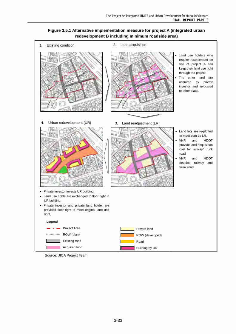
Figure 3.5.1 Alternative implementation measure for project A (integrated urban redevelopment B including minimum roadside area)
Source: JICA Project Team
Legend
Project Area
ROW (plan)
Existing road
Acquired land
1. Existing condition 2. Land acquisition
• Land use holders who require resettlement on site of project A can keep their land use right through the project.
• The other land are acquired by private investor and relocated to other place.
3. Land readjustment (LR)
• Land lots are re-plotted to meet plan by LR.
• VNR and HDOT provide land acquisition cost for railway/ trunk road
• VNR and HDOT develop railway and trunk road.
4. Urban redevelopment (UR)
Private land
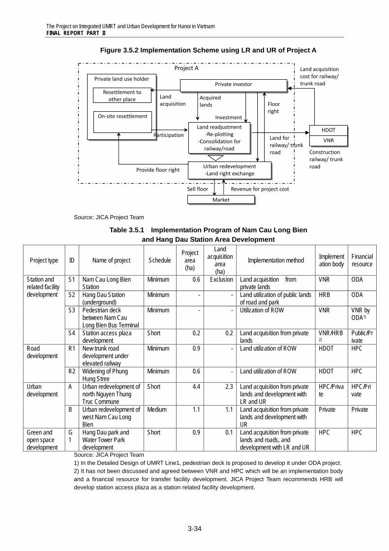
ROW (developed)
Road
Building by UR
• Private investor invests UR building. • Land use rights are exchanged to floor right in
UR building. • Private investor and private land holder are
provided floor right to meet original land use right.
Hanoi water works department
Building site for UR
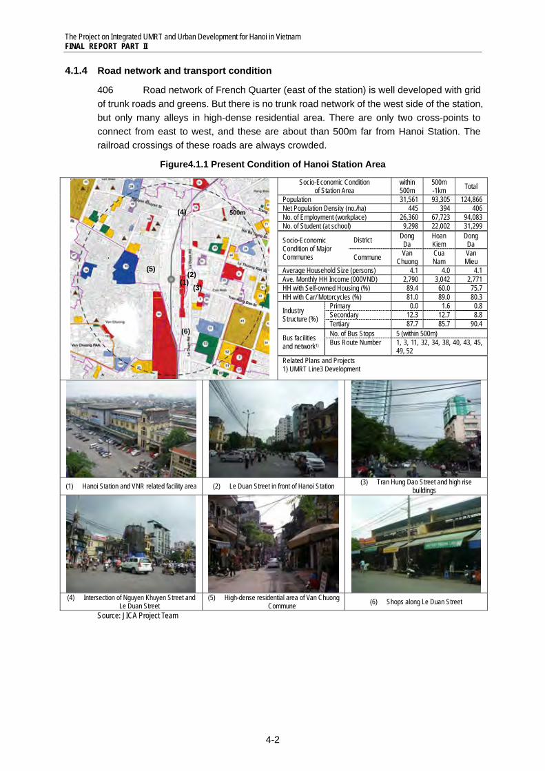
The Project on Integrated UMRT and Urban Development for Hanoi in Vietnam FINAL REPORT PART II
3-34
Figure 3.5.2 Implementation Scheme using LR and UR of Project A
Source: JICA Project Team
Table 3.5.1 Implementation Program of Nam Cau Long Bien and Hang Dau Station Area Development
Project type ID Name of project Schedule Project area (ha)
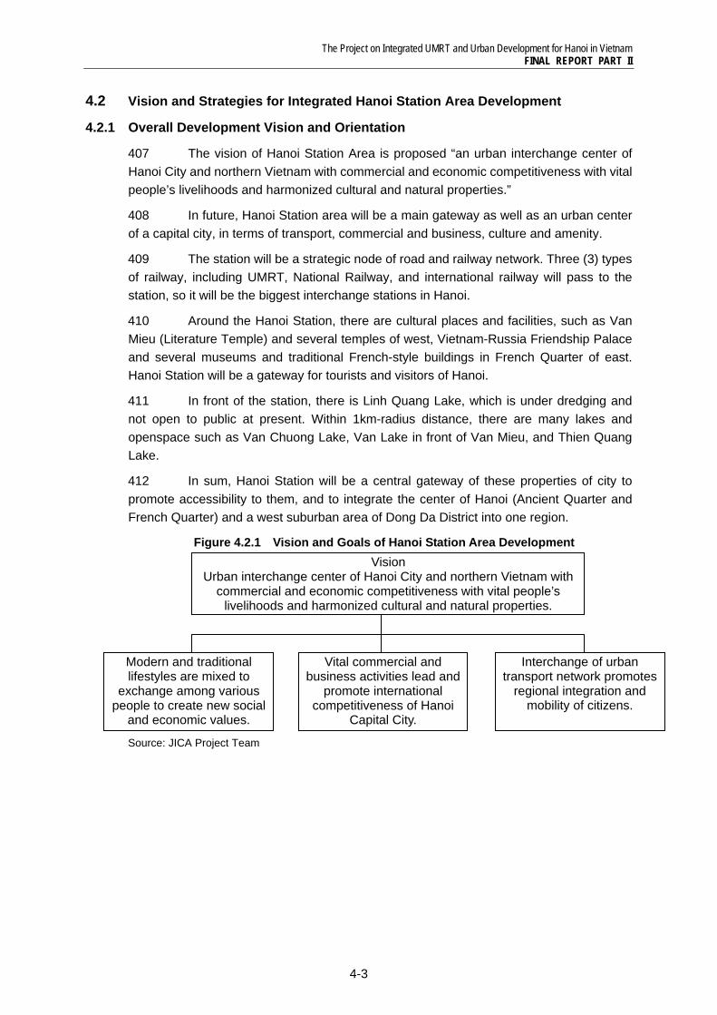
Land acquisition
area (ha)
Implementation method Implementation body
Financial resource
Station and related facility development
S1 Nam Cau Long Bien Station
Minimum 0.6 Exclusion Land acquisition from private lands
VNR ODA
S2 Hang Dau Station (underground)
Minimum - - Land utilization of public lands of road and park
HRB ODA
S3 Pedestrian deck between Nam Cau Long Bien Bus Terminal
Minimum - - Utilization of ROW VNR VNR by ODA1)
S4 Station access plaza development
Short 0.2 0.2 Land acquisition from private lands
VNR/HRB2)
Public/Private
Road development
R1 New trunk road development under elevated railway
Minimum 0.9 - Land utilization of ROW HDOT HPC
R2 Widening of Phung Hung Stree
Minimum 0.6 - Land utilization of ROW HDOT HPC
Urban development
A Urban redevelopment of north Nguyen Thung Truc Commune
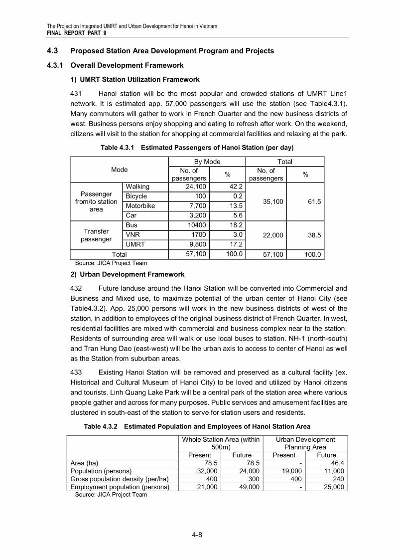
Short 4.4 2.3 Land acquisition from private lands and development with LR and UR
HPC/Private
HPC/Private
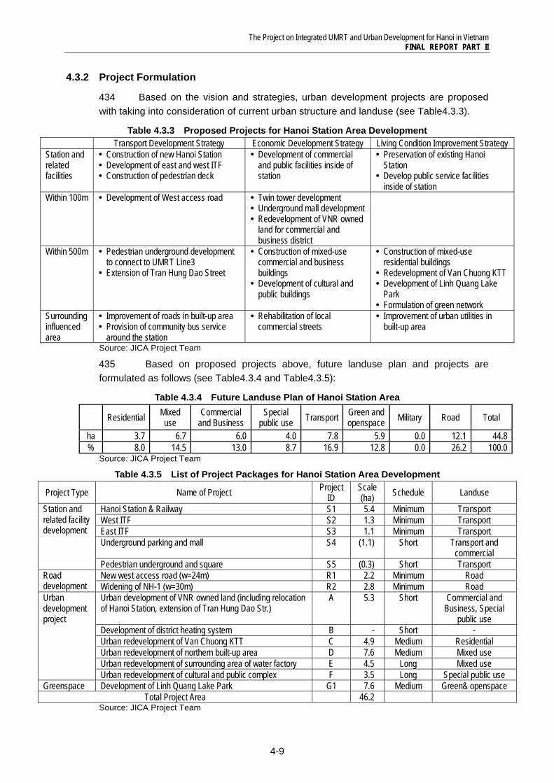
B Urban redevelopment of west Nam Cau Long Bien
Medium 1.1 1.1 Land acquisition from private lands and development with UR
Private Private
Green and open space development
G1
Hang Dau park and Water Tower Park development
Short 0.9 0.1 Land acquisition from private lands and roads, and development with LR and UR
HPC HPC
Source: JICA Project Team 1) In the Detailed Design of UMRT Line1, pedestrian deck is proposed to develop it under ODA project. 2) It has not been discussed and agreed between VNR and HPC which will be an implementation body and a financial resource for transfer facility development. JICA Project Team recommends HRB will develop station access plaza as a station related facility development.
Project A
HDOT
Private land use holder
On‐site resettlement
Resettlement to other place
Private investor
Land acquisition
Land readjustment ‐Re‐plotting
‐Consolidation for railway/road
Acquired lands
Participation
Urban redevelopment ‐Land right exchange
Investment
Provide floor right
Floor right
Market
Sell floor Revenue for project cost
VNR Land for railway/ trunk road
Land acquisition cost for railway/ trunk road
Construction railway/ trunk road
The Project on Integrated UMRT and Urban Development for Hanoi in Vietnam FINAL REPORT PART II
3-35
3.5.3 Implementation Schedule
1) Minimum development
397 Regarding station and related faculties (S1, S2), the land acquisition for ROW should be completed until 2012 and construction of station and ITF should be completed until UMRT opening in 2017.
398 Road development of R1 is implemented as combined project with elevated railway. Widening of Phung Hung (R2) should be started land acquisition by at least 2013 to meet UMRT operation in 2017.
2) Short term project
399 For the implementation station access plaza development (S4), it is necessary to coordinate among VNR and HRB. Project should be started by at least 2015.
3100 Urban redevelopment of Nguyen Thung Truc commune (A) is related with land acquisition for railway as proposed. To meet UMRT schedule, land acquisition and land readjustment should be completed by at least 2012.
3101 Regarding Han Dau park and Water Tower Park Development is scheduled after land acquisition of urban redevelopment of Nguyen Thung Truc commune (A).
3) Medium term project
3102 From viewpoint of efficient land use, it is desirable that urban redevelopment of west Nam Cau Long Bien Station is implemented as soon as possible. This project is proposed to adopt UR scheme. The establishment for the legal system also needs a time. Therefore, implementation of project B is planned from 2015.
The Project on Integrated UMRT and Urban Development for Hanoi in Vietnam FINAL REPORT PART II
3-36
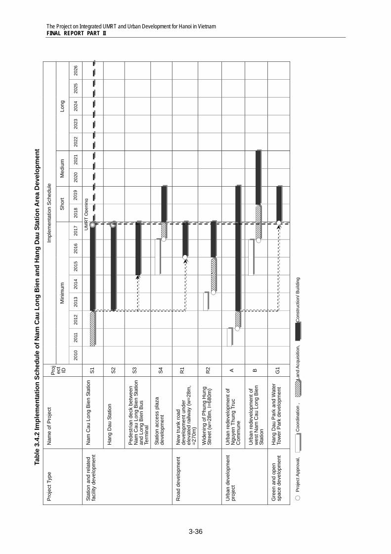
Im
plem
enta
tion
Sch
edul
e
Long
2026
2025
2024
2023
2022
Med
ium
2021
2020
Sho
rt 2019
2018
Min
imum
2017
2016
2015
2014
2013
2012
2011
2010
Pro
jec
t ID
S1
S2
S3
S4
R1
R2 A
B
G1
Nam
e of
Pro
ject
Nam
Cau
Lon
g B
ien
Stat
ion
Han
g D
au S
tatio
n
Ped
estri
an d
eck
betw
een
Nam
Cau
Lon
g B
ien
Stat
ion
and
Long
Bie
n B
us
Term
inal
Stat
ion
acce
ss p
laza
de
velo
pmen
t
New
trun
k ro
ad
deve
lopm
ent u
nder
el
evat
ed ra
ilway
(w=2
8m,
=270
m)
Wid
enin
g of
Phu
ng H
ung
Stre
et (w
=28m
, I=6
80m
)
Urb
an re
deve
lopm
ent o
f N
guye
n Th
ung
Truc
C
omm
une
Urb
an re
deve
lopm
ent o
f w
est N
am C
au L
ong
Bie
n St
atio
n
Han
g D
au P
ark
and
Wat
er
Tow
er P
ark
deve
lopm
ent
Pro
ject
Typ
e
Stat
ion
and
rela
ted
faci
lity
deve
lopm
ent
Roa
d de
velo
pmen
t U
rban
dev
elop
men
t pr
ojec
t
Gre
en a
nd o
pen
spac
e de
velo
pmen
t
Tabl
e 3.
4.2
Impl
emen
tatio
n Sc
hedu
le o
f Nam
Cau
Lon
g B
ien
and
Han
g D
au S
tatio
n A
rea
Dev
elop
men
t
UM
RT
Ope
ning
Pro
ject
App
rova
l,
Coo
rdin
atio
n ,
Lan
d Ac
quis
ition
,
C
onst
ruct
ion/
Bui
ldin
g
The Project on Integrated UMRT and Urban Development for Hanoi in Vietnam FINAL REPORT PART II
3-37
3.5.4 Project Investment and Operation Cost
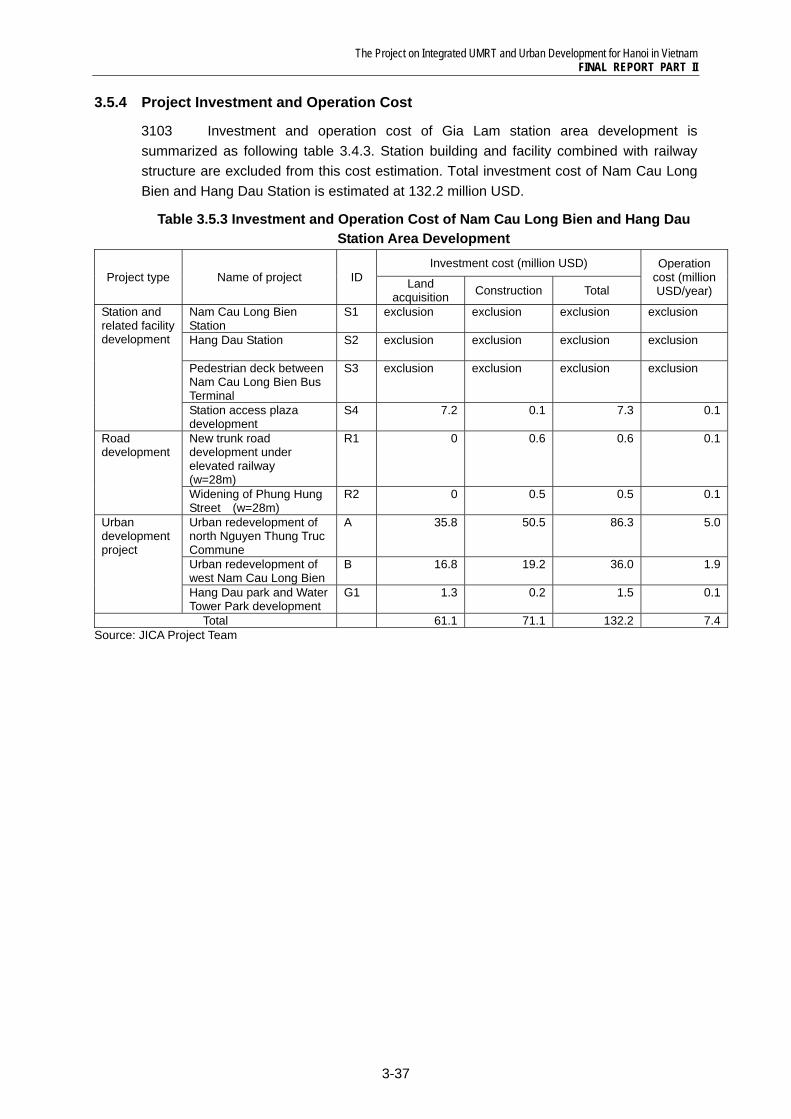
3103 Investment and operation cost of Gia Lam station area development is summarized as following table 3.4.3. Station building and facility combined with railway structure are excluded from this cost estimation. Total investment cost of Nam Cau Long Bien and Hang Dau Station is estimated at 132.2 million USD.
Table 3.5.3 Investment and Operation Cost of Nam Cau Long Bien and Hang Dau Station Area Development
Project type Name of project ID Investment cost (million USD) Operation
cost (million USD/year) Land
acquisition Construction Total
Station and related facility development
Nam Cau Long Bien Station
S1 exclusion exclusion exclusion exclusion
Hang Dau Station
S2 exclusion exclusion exclusion exclusion
Pedestrian deck between Nam Cau Long Bien Bus Terminal
S3 exclusion exclusion exclusion exclusion
Station access plaza development
S4 7.2 0.1 7.3 0.1
Road development
New trunk road development under elevated railway (w=28m)
R1 0 0.6 0.6 0.1
Widening of Phung Hung Street (w=28m)
R2 0 0.5 0.5 0.1
Urban development project
Urban redevelopment of north Nguyen Thung Truc Commune
A 35.8 50.5 86.3 5.0
Urban redevelopment of west Nam Cau Long Bien
B 16.8 19.2 36.0 1.9
Hang Dau park and Water Tower Park development
G1 1.3 0.2 1.5 0.1
Total 61.1 71.1 132.2 7.4Source: JICA Project Team
The Project on Integrated UMRT and Urban Development for Hanoi in Vietnam FINAL REPORT PART II
3-38
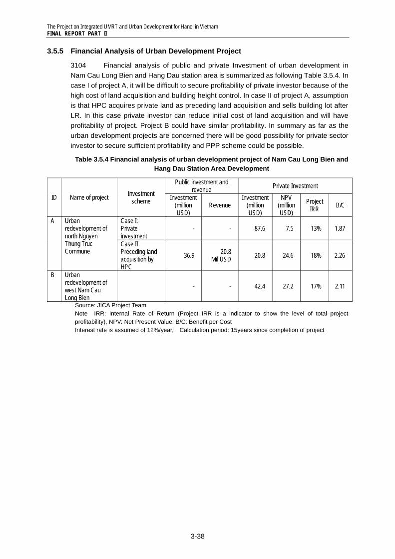
3.5.5 Financial Analysis of Urban Development Project
3104 Financial analysis of public and private Investment of urban development in Nam Cau Long Bien and Hang Dau station area is summarized as following Table 3.5.4. In case I of project A, it will be difficult to secure profitability of private investor because of the high cost of land acquisition and building height control. In case II of project A, assumption is that HPC acquires private land as preceding land acquisition and sells building lot after LR. In this case private investor can reduce initial cost of land acquisition and will have profitability of project. Project B could have similar profitability. In summary as far as the urban development projects are concerned there will be good possibility for private sector investor to secure sufficient profitability and PPP scheme could be possible.
Table 3.5.4 Financial analysis of urban development project of Nam Cau Long Bien and Hang Dau Station Area Development
ID Name of project Investment scheme
Public investment and revenue Private Investment
Investment (million USD)
Revenue Investment
(million USD)
NPV (million USD)
Project IRR B/C
A Urban redevelopment of north Nguyen Thung Truc Commune
Case I: Private investment
- - 87.6 7.5 13% 1.87
Case II Preceding land acquisition by HPC
36.9 20.8 Mil USD 20.8 24.6 18% 2.26
B Urban redevelopment of west Nam Cau Long Bien
- - 42.4 27.2 17% 2.11
Source: JICA Project Team Note IRR: Internal Rate of Return (Project IRR is a indicator to show the level of total project profitability), NPV: Net Present Value, B/C: Benefit per Cost Interest rate is assumed of 12%/year, Calculation period: 15years since completion of project
The Project on Integrated UMRT and Urban Development for Hanoi in Vietnam FINAL REPORT PART II
4-1
4 DETAILED PLAN OF HANOI STATION AREA DEVELOPMENT
4.1 Present Condition
4.1.1 General characteristics
401 Hanoi Station area covers French Quarter of Hoan Kiem District and Hai Ba Trung District in east side of station, and high-dense residential area of Dong Da District in west side. The local condition is quite different in terms of physical, economical, social and cultural characteristics.
402 The French Quarter is characterized with villa-style detached houses. Most of the actual French villas there were constructed during the French colonial period, occupy large plots, and have gardens. Because of their good location these French villas are usually used as public facilities, such as government offices and embassies, or commercial facilities, such as restaurants and retail shops with smart designs. Except for those renovated for commercial or public use, most of the housing facilities are degraded. Commercial facilities, including high-rise offices, hotels are clustered in this area.
403 In the west side of the station, Van Chuong Commune, there are many poor resident groups with low income. There are a number of industries in this area and Hanoi Station and related facilities of Vietnam Railways (about 11ha) are occupied, and it is difficult to clarify land title of each plot and property ownership of houses and entities. In the west of Linh Quang Lake, which has been stagnant, there is Van Chuong Public Apartment area, with 20 apartment buildings of 3-5 stories, built in 1960s. There is no direct approach to the major road from the apartment area, and there are no collector roads but only alleys. Drainage and waste from a market and housings and a polluted lake make the living environment worse. Gaps of social, economical and physical conditions between east side (business and cultural areas of French Quarter) and west side (residential areas of Dong Da District) of the railway are big.
4.1.2 Population
404 Estimated population of 500m radius from Hanoi Station is 32,000, while number of employees is app. 21,000 and of students is 7,000. The population density of Van Chuong Commune where Hanoi Station and west side area are located is 589persons/ha, while the density is only 194persons/ha of Tran Hung Dao Commune where is east of the station in French Quarter. On the other hand, employees are clustered in east of the station of French Quarter, where many office buildings are gathered.
4.1.3 Urban facilities
405 There are many urban facilities, including popular places for tourists. In French Quarter, there are many mid or high class hotels such as Melia Hotel, Movenpick Hotel, Hanoi Tower, etc. Embassies and ministries (Ministry of Police, Ministry of Transport) are also located in this area. Vietnam-Russia Friendship Cultural Palace is a popular facility for exhibition, performance, and various types of events. In the north-west side of Hanoi Station, Van Mieu (the Temple of Literature) is located as a historical vestige. Next to it, the Quoc Tu Giam, the temple of the first university in Vietnam is one of the popular sightseeing places in Hanoi.
The Project on Integrated UMRT and Urban Development for Hanoi in Vietnam FINAL REPORT PART II
4-2
4.1.4 Road network and transport condition
406 Road network of French Quarter (east of the station) is well developed with grid of trunk roads and greens. But there is no trunk road network of the west side of the station, but only many alleys in high-dense residential area. There are only two cross-points to connect from east to west, and these are about than 500m far from Hanoi Station. The railroad crossings of these roads are always crowded.
Figure4.1.1 Present Condition of Hanoi Station Area
Socio-Economic Condition of Station Area
within 500m
500m -1km Total
Population 31,561 93,305 124,866 Net Population Density (no./ha) 445 394 406 No. of Employment (workplace) 26,360 67,723 94,083 No. of Student (at school) 9,298 22,002 31,299
Socio-Economic Condition of Major Communes
District Dong Da
Hoan Kiem
Dong Da
Commune Van Chuong
Cua Nam
Van Mieu
Average Household Size (persons) 4.1 4.0 4.1 Ave. Monthly HH Income (000VND) 2,790 3,042 2,771 HH with Self-owned Housing (%) 89.4 60.0 75.7 HH with Car/ Motorcycles (%) 81.0 89.0 80.3
Industry Structure (%)
Primary 0.0 1.6 0.8 Secondary 12.3 12.7 8.8 Tertiary 87.7 85.7 90.4
Bus facilities and network1)
No. of Bus Stops 5 (within 500m) Bus Route Number 1, 3, 11, 32, 34, 38, 40, 43, 45,
49, 52 Related Plans and Projects 1) UMRT Line3 Development
(1) Hanoi Station and VNR related facility area (2) Le Duan Street in front of Hanoi Station (3) Tran Hung Dao Street and high rise
buildings
(4) Intersection of Nguyen Khuyen Street and
Le Duan Street (5) High-dense residential area of Van Chuong
Commune (6) Shops along Le Duan Street
Source: JICA Project Team
(1) (2)
(3)
(4)
(5)
(6)
The Project on Integrated UMRT and Urban Development for Hanoi in Vietnam FINAL REPORT PART II
4-3
4.2 Vision and Strategies for Integrated Hanoi Station Area Development
4.2.1 Overall Development Vision and Orientation
407 The vision of Hanoi Station Area is proposed “an urban interchange center of Hanoi City and northern Vietnam with commercial and economic competitiveness with vital people’s livelihoods and harmonized cultural and natural properties.”
408 In future, Hanoi Station area will be a main gateway as well as an urban center of a capital city, in terms of transport, commercial and business, culture and amenity.
409 The station will be a strategic node of road and railway network. Three (3) types of railway, including UMRT, National Railway, and international railway will pass to the station, so it will be the biggest interchange stations in Hanoi.
410 Around the Hanoi Station, there are cultural places and facilities, such as Van Mieu (Literature Temple) and several temples of west, Vietnam-Russia Friendship Palace and several museums and traditional French-style buildings in French Quarter of east. Hanoi Station will be a gateway for tourists and visitors of Hanoi.
411 In front of the station, there is Linh Quang Lake, which is under dredging and not open to public at present. Within 1km-radius distance, there are many lakes and openspace such as Van Chuong Lake, Van Lake in front of Van Mieu, and Thien Quang Lake.
412 In sum, Hanoi Station will be a central gateway of these properties of city to promote accessibility to them, and to integrate the center of Hanoi (Ancient Quarter and French Quarter) and a west suburban area of Dong Da District into one region.
Figure 4.2.1 Vision and Goals of Hanoi Station Area Development
Source: JICA Project Team
Vision Urban interchange center of Hanoi City and northern Vietnam with
commercial and economic competitiveness with vital people’s livelihoods and harmonized cultural and natural properties.
Modern and traditional lifestyles are mixed to
exchange among various people to create new social
and economic values.
Vital commercial and business activities lead and
promote international competitiveness of Hanoi
Capital City.
Interchange of urban transport network promotes
regional integration and mobility of citizens.
The Project on Integrated UMRT and Urban Development for Hanoi in Vietnam FINAL REPORT PART II
4-4
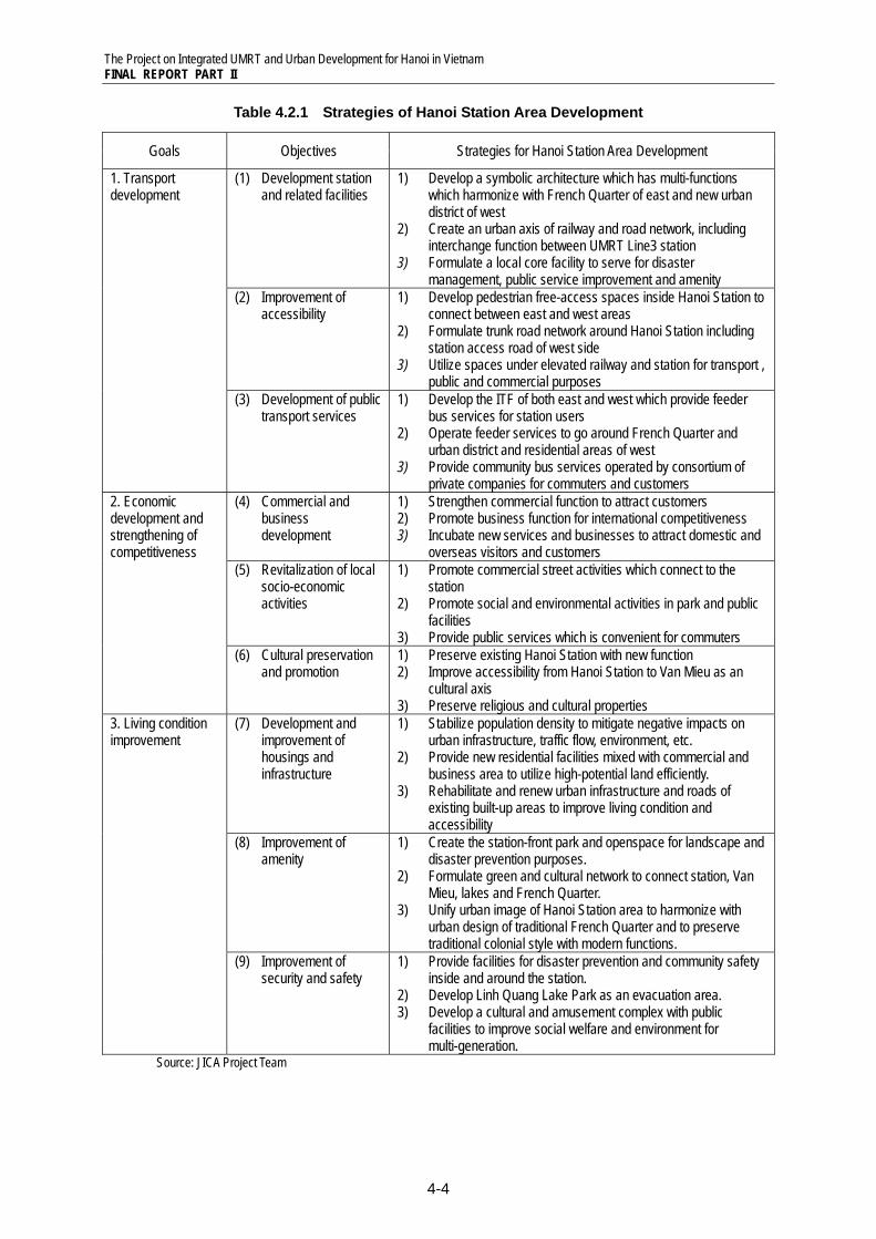
Table 4.2.1 Strategies of Hanoi Station Area Development
Goals Objectives Strategies for Hanoi Station Area Development
1. Transport development
(1) Development station and related facilities
1) Develop a symbolic architecture which has multi-functions which harmonize with French Quarter of east and new urban district of west
2) Create an urban axis of railway and road network, including interchange function between UMRT Line3 station
3) Formulate a local core facility to serve for disaster management, public service improvement and amenity
(2) Improvement of accessibility
1) Develop pedestrian free-access spaces inside Hanoi Station to connect between east and west areas
2) Formulate trunk road network around Hanoi Station including station access road of west side
3) Utilize spaces under elevated railway and station for transport , public and commercial purposes
(3) Development of public transport services
1) Develop the ITF of both east and west which provide feeder bus services for station users
2) Operate feeder services to go around French Quarter and urban district and residential areas of west
3) Provide community bus services operated by consortium of private companies for commuters and customers
2. Economic development and strengthening of competitiveness
(4) Commercial and business development
1) Strengthen commercial function to attract customers 2) Promote business function for international competitiveness 3) Incubate new services and businesses to attract domestic and
overseas visitors and customers (5) Revitalization of local
socio-economic activities
1) Promote commercial street activities which connect to the station
2) Promote social and environmental activities in park and public facilities
3) Provide public services which is convenient for commuters (6) Cultural preservation
and promotion 1) Preserve existing Hanoi Station with new function 2) Improve accessibility from Hanoi Station to Van Mieu as an
cultural axis 3) Preserve religious and cultural properties
3. Living condition improvement
(7) Development and improvement of housings and infrastructure
1) Stabilize population density to mitigate negative impacts on urban infrastructure, traffic flow, environment, etc.
2) Provide new residential facilities mixed with commercial and business area to utilize high-potential land efficiently.
3) Rehabilitate and renew urban infrastructure and roads of existing built-up areas to improve living condition and accessibility
(8) Improvement of amenity
1) Create the station-front park and openspace for landscape and disaster prevention purposes.
2) Formulate green and cultural network to connect station, Van Mieu, lakes and French Quarter.
3) Unify urban image of Hanoi Station area to harmonize with urban design of traditional French Quarter and to preserve traditional colonial style with modern functions.
(9) Improvement of security and safety
1) Provide facilities for disaster prevention and community safety inside and around the station.
2) Develop Linh Quang Lake Park as an evacuation area. 3) Develop a cultural and amusement complex with public
facilities to improve social welfare and environment for multi-generation.
Source: JICA Project Team
The Project on Integrated UMRT and Urban Development for Hanoi in Vietnam FINAL REPORT PART II
4-5
4.2.2 Transport Development Strategies and Projects
(1) Development of Station and Related Facilities
413 UMRT, National Railway and International Railway will arrive to and depart from new Hanoi Station. So the station should carry out multi-functions such as (i) interchange and transfer facilities to improve accessibility, (ii) facilities and spaces to promote opportunities of communication and information sharing, and (iii) public services and facilities for convenience of station users and local communities.
414 The development strategies for development of station and related facilities are as follows:
1) Develop a symbolic architecture which has multi-functions which harmonize with French Quarter of east and new urban district of west
2) Create an urban axis of railway and road network, including interchange function between UMRT Line3 station
3) Formulate a local core facility to serve for disaster management, public service improvement and amenity
(2) Improvement of Accessibility
415 At present, Hanoi Station and railway is a barrier between east and west districts. Only Nguyen Thai Hoc Street of north and Kham Thien Street of south are trunk roads to connect between east and west. Though road network in French Quarter is formulated, there are no trunk roads of west side of station. There is a parking space is in front of the station, but space is limited, so there are many roadside parking in French Quarter.
416 The development strategies for improvement accessibility are as follows:
1) Develop pedestrian free-access spaces inside Hanoi Station to connect between east and west areas
2) Formulate trunk road network around Hanoi Station including station access road of west side
3) Utilize spaces under railway, station and underground to integrate transport facility into commercial and business facilities
(3) Development of Public Transport Services
417 Because of lack of road network, buses operate mainly along NH-1 and in French Quarter. Though there are many urban facilities in French Quarter and tourism spots such as Van Mieu, it is difficult for station users to access to destination facilities on foot or by public buses at present.
418 The development strategies for development of public transport services are as follows:
1) Develop the ITF of both east and west which provide feeder bus services for station users
2) Operate feeder services to go around French Quarter and urban district and residential areas of west
The Project on Integrated UMRT and Urban Development for Hanoi in Vietnam FINAL REPORT PART II
4-6
3) Provide community bus services operated by consortium of private companies for commuters and customers
4.2.3 Economic Development Strategies and Projects
(1) Commercial and business development
419 Though there are many government buildings, office buildings and hotels in French Quarter, commercial facilities are few. Commuters cannot enjoy shopping after work. Potential of commercial and business development should be promoted to be a CBD of Hanoi City.
420 The development strategies for commercial and business development are as follows:
1) Strengthen commercial function to attract customers
2) Promote business function for international competitiveness
3) Incubate new services and businesses to attract domestic and overseas visitors and customers
(2) Revitalization of Local Socio-Economic Activities
421 In west of the station, many retail shops and local markets are clustered, but it is not attractive enough to pull in customers. While new commercial and business facilities will be developed, local services for daily life should be preserved and improved.
422 The development strategies for revitalization of local socio-economic activities are as follows:
1) Promote commercial street activities which connect to the station
2) Promote social and environmental activities in park and public facilities
3) Provide public services which is convenient for commuters
(3) Cultural Preservation and Promotion
423 There are various cultural facilities such as Van Mieu, Friendship Palace, pagodas and temples around the Hanoi Station. In French Quarter, there are many traditional colonial style architecture. Existing Hanoi Station, which is mixed form of French and Russian style is one of historical heritages of Hanoi City.
424 The development strategies for cultural preservation and promotion are as follows:
1) Preserve existing Hanoi Station with new function
2) Improve accessibility from Hanoi Station to Van Mieu as an cultural axis
3) Preserve religious and cultural properties
4.2.4 Living Condition Improvement Strategy and Projects
(1) Development and improvement of housings and infrastructure
The Project on Integrated UMRT and Urban Development for Hanoi in Vietnam FINAL REPORT PART II
4-7
425 At present, the west station area is high-dense and is worsen infrastructure, such as unregulated narrow alleys, overloaded drainage and electricity, deteriorated water channels, etc. On the contrary, the French Quarter of east station area, road network is well organized. But recently many high-rise buildings are constructed, so urban infrastructure will not be enough in future.
426 The development strategies for improvement of housing and infrastructure are as follows:
1) Stabilize population density to mitigate negative impacts on urban infrastructure, traffic flow, environment, etc.
2) Provide new residential facilities mixed with commercial and business area to utilize high-potential land efficiently.
3) Rehabilitate and renew urban infrastructure and roads of existing built-up areas to improve living condition and accessibility
(2) Improvement of Amenity
427 Around the Hanoi Station, there are some environmental and cultural spaces such as Van Mieu, Linh Quang Lake, Van Chuong Lake, etc. But lakes and water channels are stagnated and accumulated with pollutants and garbage. So these lakes are not open for public for recreation purposes. Urban design of French Quarter is controlled by Decision, but there are several new buildings which is too high or the design is not harmonized with traditional style of French Quarter.
428 The development strategies for improvement of amenity are as follows:
1) Create the station-front park and openspace for landscape and disaster prevention purposes.
2) Formulate green and cultural network to connect station, Van Mieu, lakes and French Quarter.
3) Unify urban image of Hanoi Station area to harmonize with urban design of traditional French Quarter and to preserve traditional colonial style with modern functions.
(3) Improvement of Security and Safety
429 Narrow alleys are confusing with dead spaces in built-up area of west side of the station. It is weak for disaster, especially flood, and there are no fire proof and evacuation measures. Since station users will pass through these built-up areas, well-organized urban structure is necessary for disaster prevention and community safety.
430 The development strategies for improvement of security and safety are as follows:
1) Provide facilities for disaster prevention and community safety inside and around the station.
2) Develop Linh Quang Lake Park as an evacuation area.
3) Develop a cultural and amusement complex with public facilities to improve social welfare and environment for multi-generation.
The Project on Integrated UMRT and Urban Development for Hanoi in Vietnam FINAL REPORT PART II
4-8
4.3 Proposed Station Area Development Program and Projects
4.3.1 Overall Development Framework
1) UMRT Station Utilization Framework
431 Hanoi station will be the most popular and crowded stations of UMRT Line1 network. It is estimated app. 57,000 passengers will use the station (see Table4.3.1). Many commuters will gather to work in French Quarter and the new business districts of west. Business persons enjoy shopping and eating to refresh after work. On the weekend, citizens will visit to the station for shopping at commercial facilities and relaxing at the park.
Table 4.3.1 Estimated Passengers of Hanoi Station (per day)
Mode By Mode Total
No. of passengers % No. of
passengers %
Passenger from/to station
area
Walking 24,100 42.2
35,100 61.5 Bicycle 100 0.2 Motorbike 7,700 13.5 Car 3,200 5.6
Transfer passenger
Bus 10400 18.2 22,000 38.5 VNR 1700 3.0
UMRT 9,800 17.2 Total 57,100 100.0 57,100 100.0
Source: JICA Project Team
2) Urban Development Framework
432 Future landuse around the Hanoi Station will be converted into Commercial and Business and Mixed use, to maximize potential of the urban center of Hanoi City (see Table4.3.2). App. 25,000 persons will work in the new business districts of west of the station, in addition to employees of the original business district of French Quarter. In west, residential facilities are mixed with commercial and business complex near to the station. Residents of surrounding area will walk or use local buses to station. NH-1 (north-south) and Tran Hung Dao (east-west) will be the urban axis to access to center of Hanoi as well as the Station from suburban areas.
433 Existing Hanoi Station will be removed and preserved as a cultural facility (ex. Historical and Cultural Museum of Hanoi City) to be loved and utilized by Hanoi citizens and tourists. Linh Quang Lake Park will be a central park of the station area where various people gather and across for many purposes. Public services and amusement facilities are clustered in south-east of the station to serve for station users and residents.
Table 4.3.2 Estimated Population and Employees of Hanoi Station Area
Whole Station Area (within 500m)
Urban Development Planning Area
Present Future Present Future Area (ha) 78.5 78.5 - 46.4 Population (persons) 32,000 24,000 19,000 11,000 Gross population density (per/ha) 400 300 400 240 Employment population (persons) 21,000 49,000 - 25,000
Source: JICA Project Team
The Project on Integrated UMRT and Urban Development for Hanoi in Vietnam FINAL REPORT PART II
4-9
4.3.2 Project Formulation
434 Based on the vision and strategies, urban development projects are proposed with taking into consideration of current urban structure and landuse (see Table4.3.3).
Table 4.3.3 Proposed Projects for Hanoi Station Area Development Transport Development Strategy Economic Development Strategy Living Condition Improvement Strategy
Station and related facilities
Construction of new Hanoi Station Development of east and west ITF Construction of pedestrian deck
Development of commercial and public facilities inside of station
Preservation of existing Hanoi Station
Develop public service facilities inside of station
Within 100m Development of West access road Twin tower development Underground mall development Redevelopment of VNR owned land for commercial and business district
Within 500m Pedestrian underground development to connect to UMRT Line3
Extension of Tran Hung Dao Street
Construction of mixed-use commercial and business buildings
Development of cultural and public buildings
Construction of mixed-use residential buildings
Redevelopment of Van Chuong KTT Development of Linh Quang Lake Park Formulation of green network
Surrounding influenced area
Improvement of roads in built-up area Provision of community bus service around the station
Rehabilitation of local commercial streets
Improvement of urban utilities in built-up area
Source: JICA Project Team
435 Based on proposed projects above, future landuse plan and projects are formulated as follows (see Table4.3.4 and Table4.3.5):
Table 4.3.4 Future Landuse Plan of Hanoi Station Area
Residential Mixed use
Commercial and Business
Special public use Transport Green and
openspace Military Road Total
ha 3.7 6.7 6.0 4.0 7.8 5.9 0.0 12.1 44.8 % 8.0 14.5 13.0 8.7 16.9 12.8 0.0 26.2 100.0
Source: JICA Project Team
Table 4.3.5 List of Project Packages for Hanoi Station Area Development
Project Type Name of Project Project ID
Scale (ha) Schedule Landuse
Station and related facility development
Hanoi Station & Railway S1 5.4 Minimum Transport West ITF S2 1.3 Minimum Transport East ITF S3 1.1 Minimum Transport Underground parking and mall S4 (1.1) Short Transport and
commercial Pedestrian underground and square S5 (0.3) Short Transport
Road development
New west access road (w=24m) R1 2.2 Minimum Road Widening of NH-1 (w=30m) R2 2.8 Minimum Road
Urban development project
Urban development of VNR owned land (including relocation of Hanoi Station, extension of Tran Hung Dao Str.)
A 5.3 Short Commercial and Business, Special
public use Development of district heating system B - Short - Urban redevelopment of Van Chuong KTT C 4.9 Medium Residential Urban redevelopment of northern built-up area D 7.6 Medium Mixed use Urban redevelopment of surrounding area of water factory E 4.5 Long Mixed use Urban redevelopment of cultural and public complex F 3.5 Long Special public use
Greenspace Development of Linh Quang Lake Park G1 7.6 Medium Green& openspace Total Project Area 46.2
Source: JICA Project Team
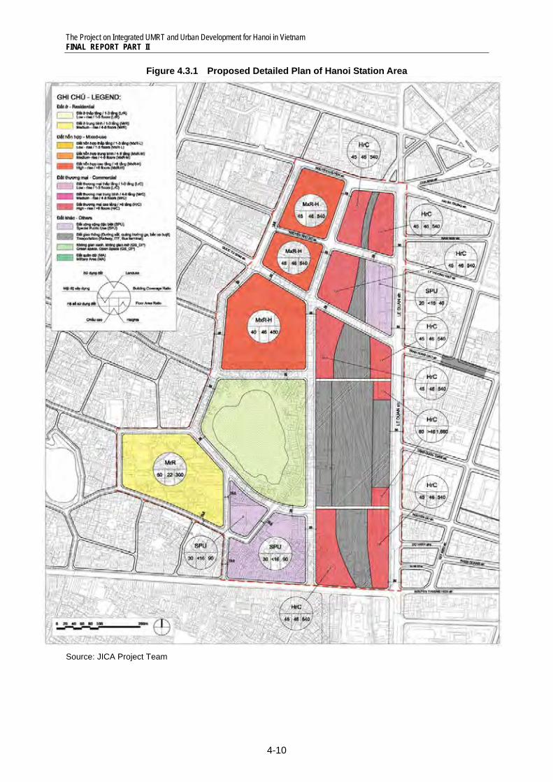
The Project on Integrated UMRT and Urban Development for Hanoi in Vietnam FINAL REPORT PART II
4-10
Figure 4.3.1 Proposed Detailed Plan of Hanoi Station Area
Source: JICA Project Team
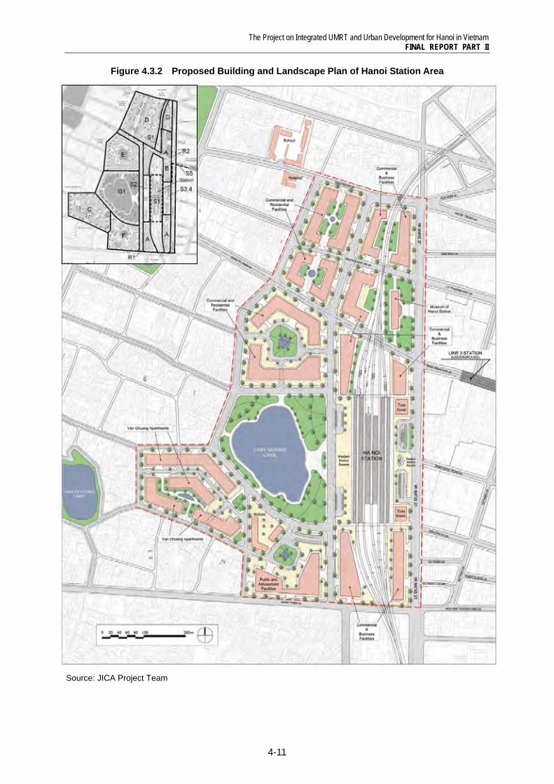
The Project on Integrated UMRT and Urban Development for Hanoi in Vietnam FINAL REPORT PART II
4-11
Figure 4.3.2 Proposed Building and Landscape Plan of Hanoi Station Area
Source: JICA Project Team
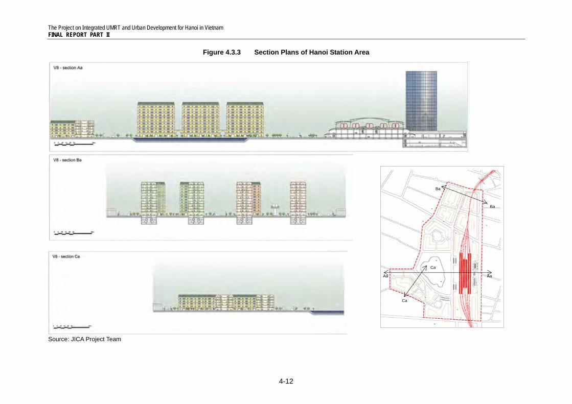
The Project on Integrated UMRT and Urban Development for Hanoi in Vietnam FINAL REPORT PART II
4-12
Figure 4.3.3 Section Plans of Hanoi Station Area
Source: JICA Project Team
Aa Aa
Ba
Ba
Ca
Ca
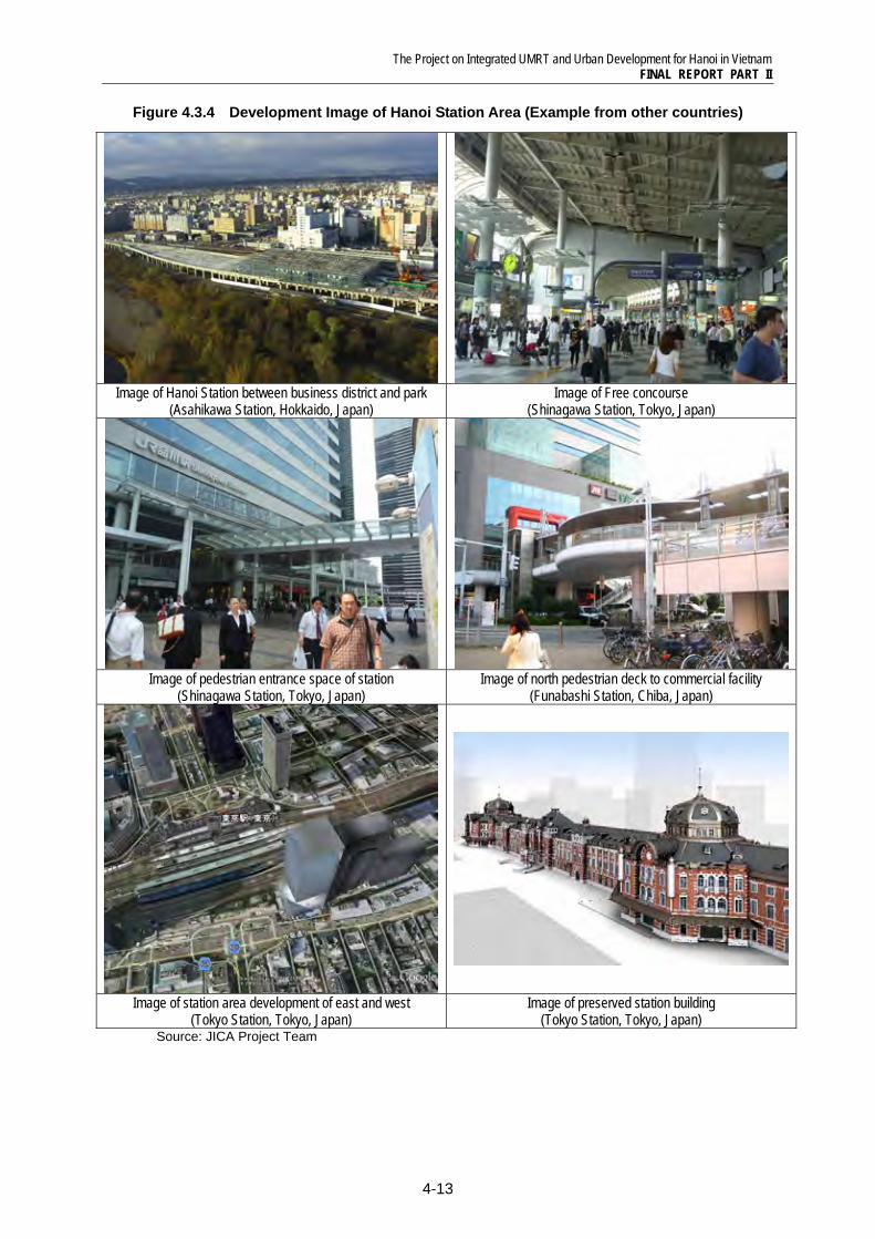
The Project on Integrated UMRT and Urban Development for Hanoi in Vietnam FINAL REPORT PART II
4-13
Figure 4.3.4 Development Image of Hanoi Station Area (Example from other countries)
Image of Hanoi Station between business district and park
(Asahikawa Station, Hokkaido, Japan) Image of Free concourse
(Shinagawa Station, Tokyo, Japan)
Image of pedestrian entrance space of station
(Shinagawa Station, Tokyo, Japan) Image of north pedestrian deck to commercial facility
(Funabashi Station, Chiba, Japan)
Image of station area development of east and west (Tokyo Station, Tokyo, Japan)
Image of preserved station building (Tokyo Station, Tokyo, Japan)
Source: JICA Project Team
The Project on Integrated UMRT and Urban Development for Hanoi in Vietnam FINAL REPORT PART II
4-14
4.3.3 Station and Related Facilities Development Plan (Project S1, S2, S3, S4, S5)
436 Station Facility: The platforms will be constructed at 3rd floor level, and concourse and ticket gates are located at 2nd floor. Since width of the station will be app. 100m, the structure will be a barrier of local communities. To improve connectivity and accessibility from both sides, the ground floor and free concourse at 2nd floor will be opened to pedestrian to cross between east and west of railway. Space of the ground floor will be used for motorbike and vehicle parking spaces, tenant spaces, and disaster prevention facilities (ex. storages of emergency food, water and medical care facilities). At the free concourse of 2nd floor, various facilities which are convenient for station users especially commuters and tourists will be located, such as café, restaurants, bookstore, and public service facilities (ex. exhibition space, admin service center), etc.
437 East Intermodal Transfer Facility: Intermodal Transfer Facility will be developed both in east and west (see Figure 4.3.5, Figure 4.3.6). The East ITF is in front of NH-1, so transfer facilities and functions will be promoted including bus stops of long-distance buses. Under the East ITF, underground parking facilities will be developed. It is proposed to develop underground shopping mall, which will connect to underground pedestrian space of UMRT Line1 and Line3 station under the intersection of NH-1 and Tran Hung Dao Street (see Figure 4.3.7). Above the East ITF, pedestrian deck will be constructed to access to sidewalks of NH-1, and twin tower in future. In sum, accessibility of pedestrian will be secured by underground space and pedestrian deck.
438 West Intermodal Transfer Facility: The West ITF will be developed to serve for pedestrian to access to new commercial and business districts as well as existing residential areas. While berth for bus, taxi and private cars will be developed along the new west access road, most of spaces of ITF will be utilized as a pedestrian space. It is recommended to develop kiosk, café, police station, etc. which citizens will enjoy and relax.
4.3.4 Road Development Plan (Project R1 and R2)
439 At present, appropriate road network around Hanoi Station is not formulated. It is necessary to develop trunk roads of north-side and west-side of station together with UMRT station development to improve accessibility to station. At present, the alignment of west trunk road is approved in front of the station. In this case, it is impossible to develop the west ITF, but the access road is directly in front of the station entrance space (see “Alternative B” of Figure4.3.8). Since many urban facilities will be developed in west of the station, intermodal transfer facilities are necessary by all means (see “Alternative A” of Figure4.3.9).
440 It is proposed to operate a community bus around west side of station, which will make an excursion connecting new commercial and business district, hospitals, Van Mieu and cultural district.
441 Parking spaces will be provided in the East Intermodal Facility and north and south of station at ground. In addition, underground parking space will be developed under the East ITF. It is recommended commercial facilities are required to develop parking spaces for users.
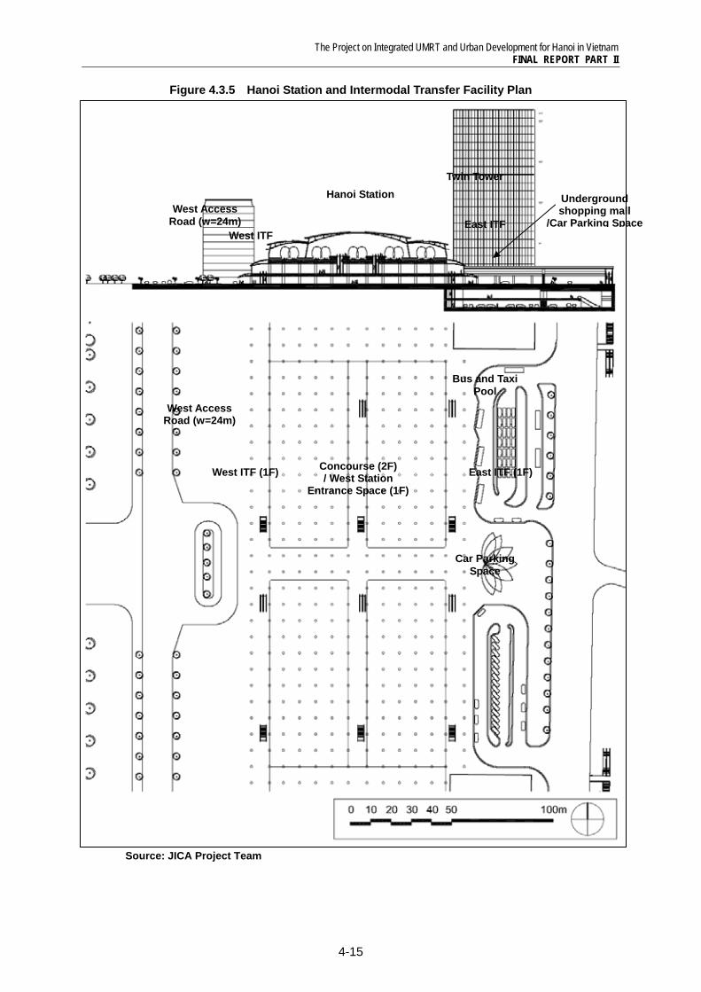
The Project on Integrated UMRT and Urban Development for Hanoi in Vietnam FINAL REPORT PART II
4-15
Figure 4.3.5 Hanoi Station and Intermodal Transfer Facility Plan
Source: JICA Project Team
Concourse (2F)/ West Station
Entrance Space (1F)West ITF (1F)
West Access Road (w=24m)
East ITF (1F)
Bus and Taxi Pool
Car Parking Space
Twin Tower
West ITF
West Access Road (w=24m)
Hanoi Station
East ITF
Underground shopping mall
/Car Parking Space
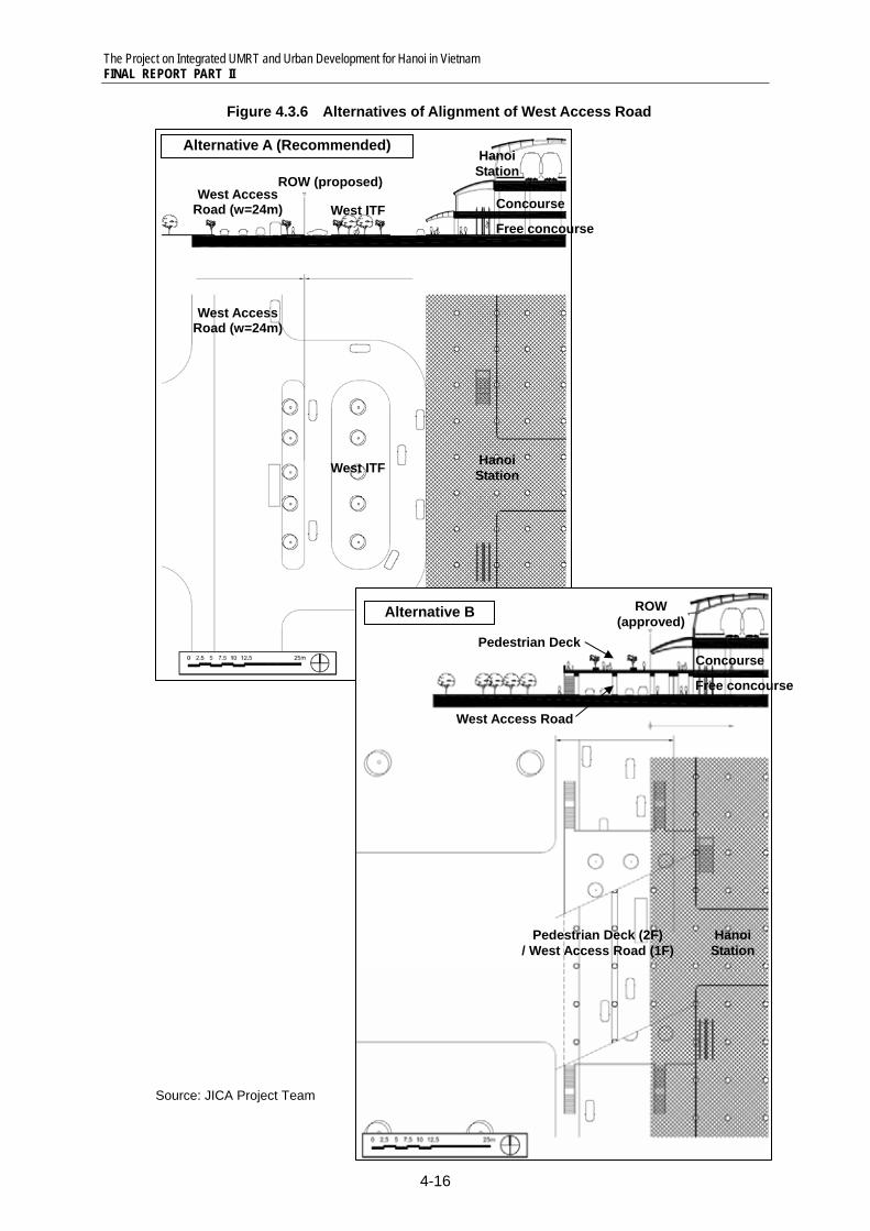
The Project on Integrated UMRT and Urban Development for Hanoi in Vietnam FINAL REPORT PART II
4-16
Figure 4.3.6 Alternatives of Alignment of West Access Road
Source: JICA Project Team
Alternative A (Recommended)
West ITF
West Access Road (w=24m)
Hanoi Station
West Access Road (w=24m) West ITF
ROW (proposed)
Hanoi Station
Concourse
Free concourse
Alternative B
Hanoi Station
Pedestrian Deck (2F) / West Access Road (1F)
ROW (approved)
Pedestrian Deck
West Access Road
Concourse
Free concourse
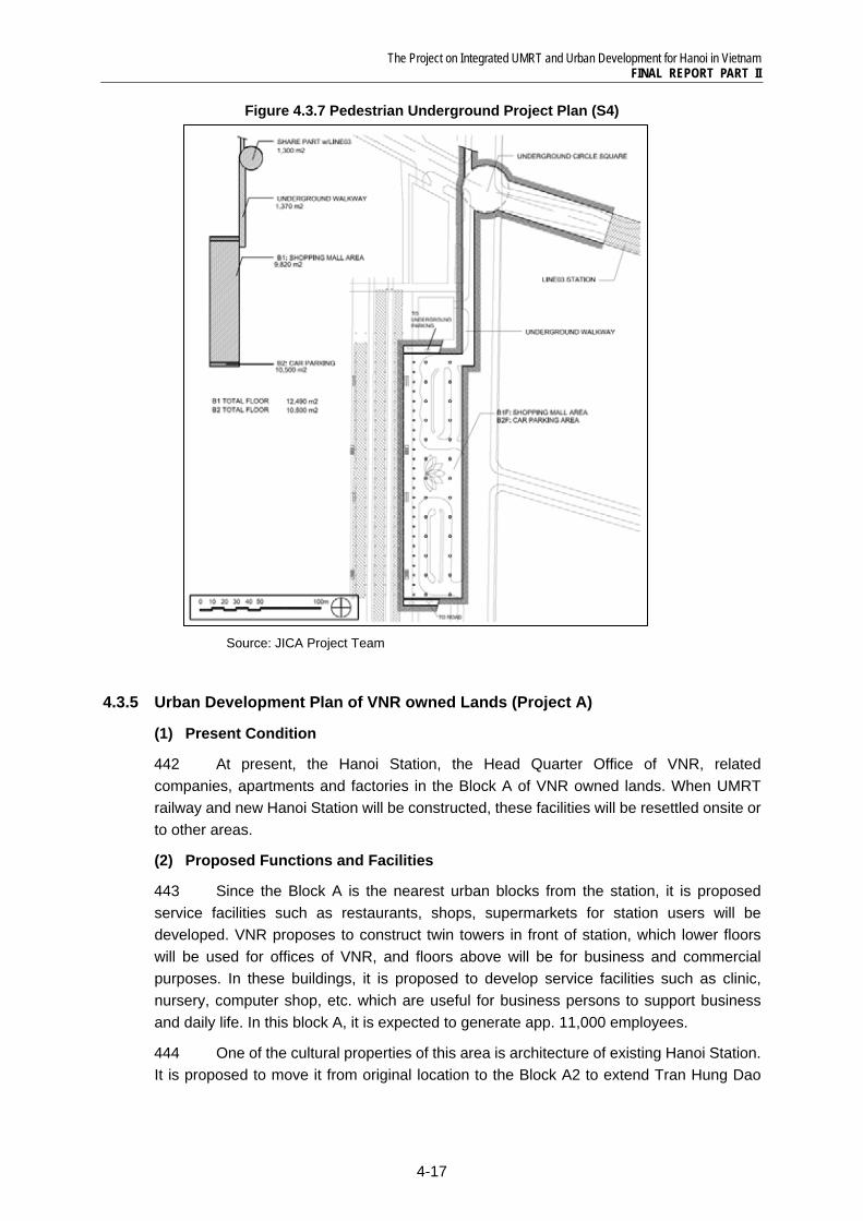
The Project on Integrated UMRT and Urban Development for Hanoi in Vietnam FINAL REPORT PART II
4-17
Figure 4.3.7 Pedestrian Underground Project Plan (S4)
Source: JICA Project Team
4.3.5 Urban Development Plan of VNR owned Lands (Project A)
(1) Present Condition
442 At present, the Hanoi Station, the Head Quarter Office of VNR, related companies, apartments and factories in the Block A of VNR owned lands. When UMRT railway and new Hanoi Station will be constructed, these facilities will be resettled onsite or to other areas.
(2) Proposed Functions and Facilities
443 Since the Block A is the nearest urban blocks from the station, it is proposed service facilities such as restaurants, shops, supermarkets for station users will be developed. VNR proposes to construct twin towers in front of station, which lower floors will be used for offices of VNR, and floors above will be for business and commercial purposes. In these buildings, it is proposed to develop service facilities such as clinic, nursery, computer shop, etc. which are useful for business persons to support business and daily life. In this block A, it is expected to generate app. 11,000 employees.
444 One of the cultural properties of this area is architecture of existing Hanoi Station. It is proposed to move it from original location to the Block A2 to extend Tran Hung Dao
The Project on Integrated UMRT and Urban Development for Hanoi in Vietnam FINAL REPORT PART II
4-18
Street to west. The original building will be preserved for another purpose (ex. museum, restaurant, etc.) to attract visitors.
Table4.3.5 Project Profile of Block A of Hanoi Station Area Development
A1 A2 A3 A4 A5 A6 Road
Development Framework
No of Population 0 0 0 0 0 0 -
No. of Employee 2,822 16 1,272 2,133 2,276 2,726 -
Construction plan
Land area (m2) 3,600 10,248 5,049 8,466 9,031 10,818 5,980
Building area (m2) 2,880 1,710 2,272 3,810 4,064 4,868 -
BCR (%) 80.0 16.7 45.0 45.0 45.0 45.0 -
Total floor area (m2) 60,480 3,420 27,265 45,716 48,767 58,417 -
No. of floor 21 2 12 12 12 12 -
FAR (%) 1,680 33.4 540 540 540 540 -
Source: JICA Project Team
4.3.6 Development of District Heating System (Project B)
445 To improve living condition of high-dense residential areas of west of Hanoi Station, urban redevelopment projects and road development projects are proposed. Urban infrastructure such as water supply, drainage, electricity will be developed with these projects. It is considered to develop “district heating” system, which provide cold and hot water and heating from underground plant system to buildings inside a specified district. For improvement of urban infrastructure in built-up residential areas, it is recommended to improve with road improvement projects.
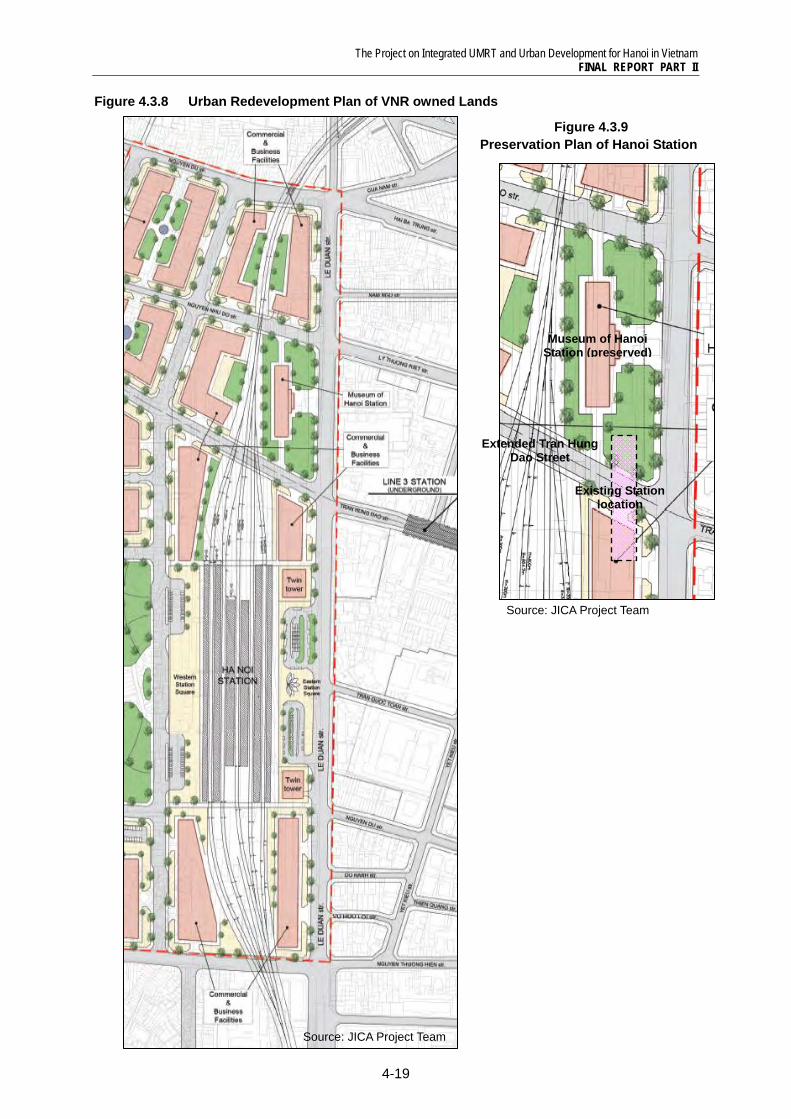
The Project on Integrated UMRT and Urban Development for Hanoi in Vietnam FINAL REPORT PART II
4-19
Figure 4.3.8 Urban Redevelopment Plan of VNR owned Lands
Figure 4.3.9 Preservation Plan of Hanoi Station
Source: JICA Project Team
Museum of Hanoi Station (preserved)
Extended Tran Hung Dao Street
Existing Station location
Source: JICA Project Team
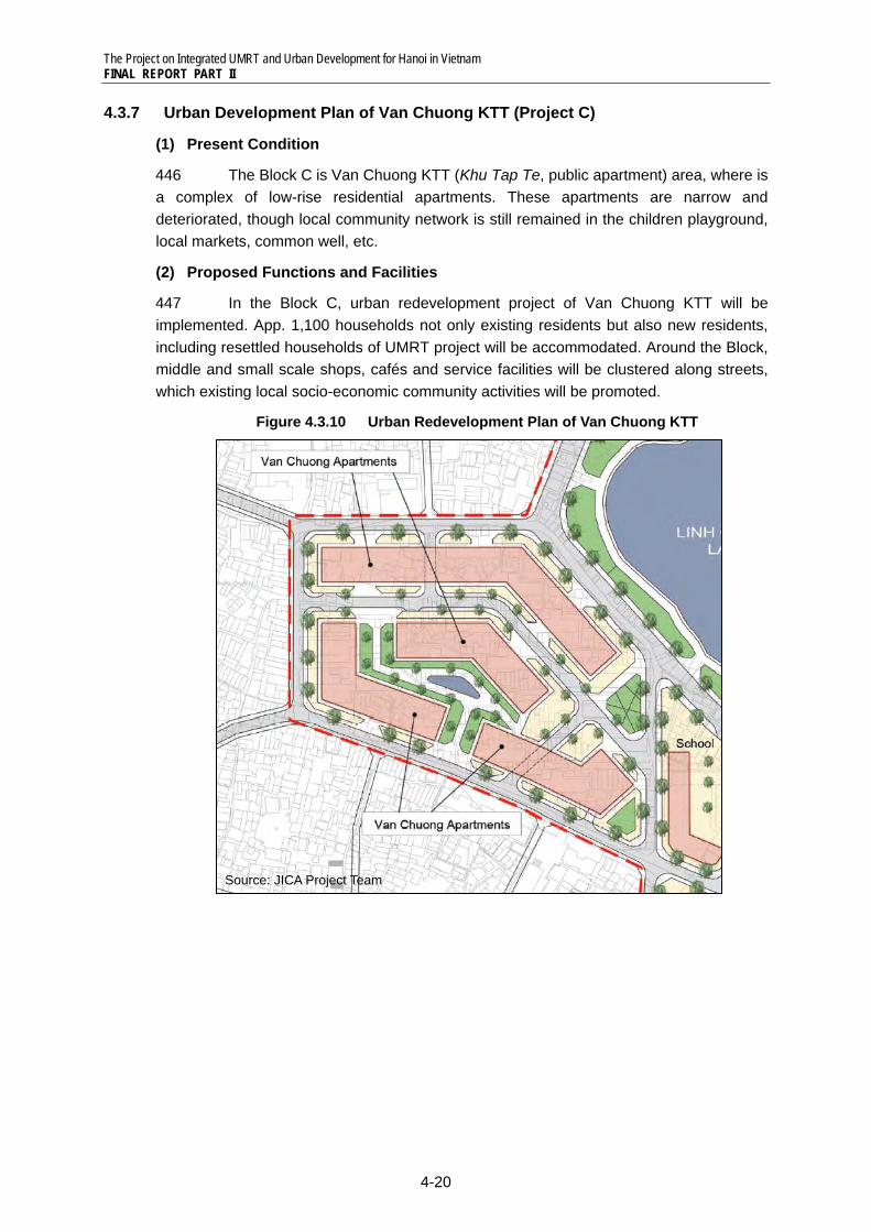
The Project on Integrated UMRT and Urban Development for Hanoi in Vietnam FINAL REPORT PART II
4-20
4.3.7 Urban Development Plan of Van Chuong KTT (Project C)
(1) Present Condition
446 The Block C is Van Chuong KTT (Khu Tap Te, public apartment) area, where is a complex of low-rise residential apartments. These apartments are narrow and deteriorated, though local community network is still remained in the children playground, local markets, common well, etc.
(2) Proposed Functions and Facilities
447 In the Block C, urban redevelopment project of Van Chuong KTT will be implemented. App. 1,100 households not only existing residents but also new residents, including resettled households of UMRT project will be accommodated. Around the Block, middle and small scale shops, cafés and service facilities will be clustered along streets, which existing local socio-economic community activities will be promoted.
Figure 4.3.10 Urban Redevelopment Plan of Van Chuong KTT
Source: JICA Project Team
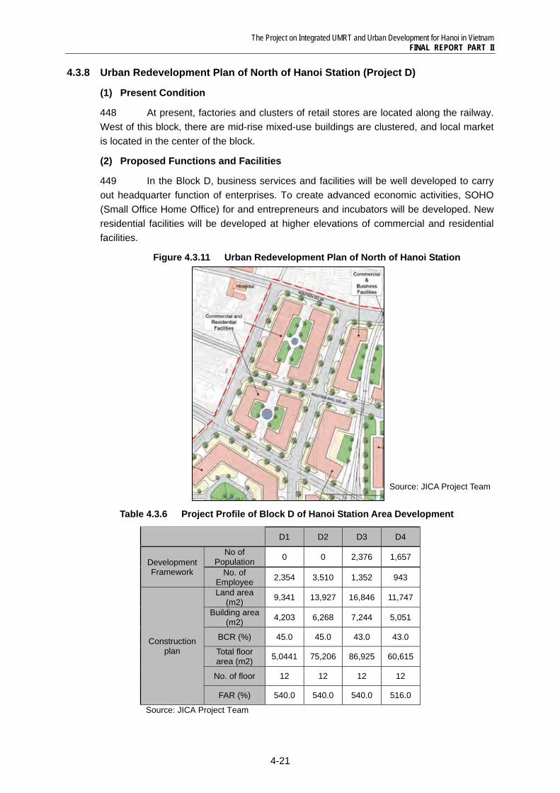
The Project on Integrated UMRT and Urban Development for Hanoi in Vietnam FINAL REPORT PART II
4-21
4.3.8 Urban Redevelopment Plan of North of Hanoi Station (Project D)
(1) Present Condition
448 At present, factories and clusters of retail stores are located along the railway. West of this block, there are mid-rise mixed-use buildings are clustered, and local market is located in the center of the block.
(2) Proposed Functions and Facilities
449 In the Block D, business services and facilities will be well developed to carry out headquarter function of enterprises. To create advanced economic activities, SOHO (Small Office Home Office) for and entrepreneurs and incubators will be developed. New residential facilities will be developed at higher elevations of commercial and residential facilities.
Figure 4.3.11 Urban Redevelopment Plan of North of Hanoi Station
Table 4.3.6 Project Profile of Block D of Hanoi Station Area Development
D1 D2 D3 D4
Development Framework
No of Population 0 0 2,376 1,657
No. of Employee 2,354 3,510 1,352 943
Construction plan
Land area (m2) 9,341 13,927 16,846 11,747
Building area (m2) 4,203 6,268 7,244 5,051
BCR (%) 45.0 45.0 43.0 43.0
Total floor area (m2) 5,0441 75,206 86,925 60,615
No. of floor 12 12 12 12
FAR (%) 540.0 540.0 540.0 516.0
Source: JICA Project Team
Source: JICA Project Team
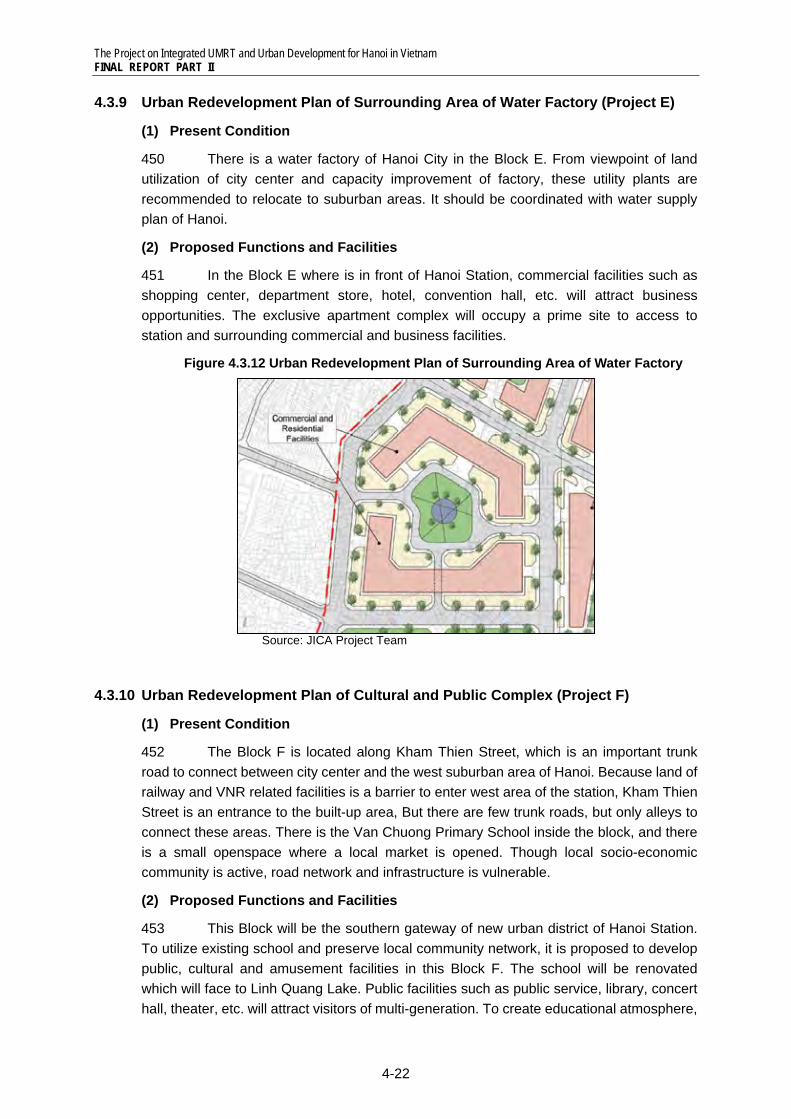
The Project on Integrated UMRT and Urban Development for Hanoi in Vietnam FINAL REPORT PART II
4-22
4.3.9 Urban Redevelopment Plan of Surrounding Area of Water Factory (Project E)
(1) Present Condition
450 There is a water factory of Hanoi City in the Block E. From viewpoint of land utilization of city center and capacity improvement of factory, these utility plants are recommended to relocate to suburban areas. It should be coordinated with water supply plan of Hanoi.
(2) Proposed Functions and Facilities
451 In the Block E where is in front of Hanoi Station, commercial facilities such as shopping center, department store, hotel, convention hall, etc. will attract business opportunities. The exclusive apartment complex will occupy a prime site to access to station and surrounding commercial and business facilities.
Figure 4.3.12 Urban Redevelopment Plan of Surrounding Area of Water Factory
Source: JICA Project Team
4.3.10 Urban Redevelopment Plan of Cultural and Public Complex (Project F)
(1) Present Condition
452 The Block F is located along Kham Thien Street, which is an important trunk road to connect between city center and the west suburban area of Hanoi. Because land of railway and VNR related facilities is a barrier to enter west area of the station, Kham Thien Street is an entrance to the built-up area, But there are few trunk roads, but only alleys to connect these areas. There is the Van Chuong Primary School inside the block, and there is a small openspace where a local market is opened. Though local socio-economic community is active, road network and infrastructure is vulnerable.
(2) Proposed Functions and Facilities
453 This Block will be the southern gateway of new urban district of Hanoi Station. To utilize existing school and preserve local community network, it is proposed to develop public, cultural and amusement facilities in this Block F. The school will be renovated which will face to Linh Quang Lake. Public facilities such as public service, library, concert hall, theater, etc. will attract visitors of multi-generation. To create educational atmosphere,
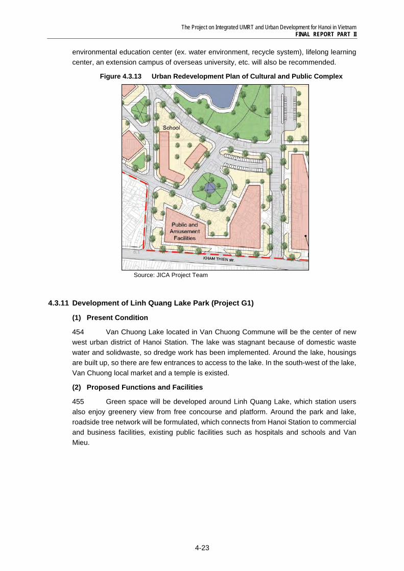
The Project on Integrated UMRT and Urban Development for Hanoi in Vietnam FINAL REPORT PART II
4-23
environmental education center (ex. water environment, recycle system), lifelong learning center, an extension campus of overseas university, etc. will also be recommended.
Figure 4.3.13 Urban Redevelopment Plan of Cultural and Public Complex
Source: JICA Project Team
4.3.11 Development of Linh Quang Lake Park (Project G1)
(1) Present Condition
454 Van Chuong Lake located in Van Chuong Commune will be the center of new west urban district of Hanoi Station. The lake was stagnant because of domestic waste water and solidwaste, so dredge work has been implemented. Around the lake, housings are built up, so there are few entrances to access to the lake. In the south-west of the lake, Van Chuong local market and a temple is existed.
(2) Proposed Functions and Facilities
455 Green space will be developed around Linh Quang Lake, which station users also enjoy greenery view from free concourse and platform. Around the park and lake, roadside tree network will be formulated, which connects from Hanoi Station to commercial and business facilities, existing public facilities such as hospitals and schools and Van Mieu.
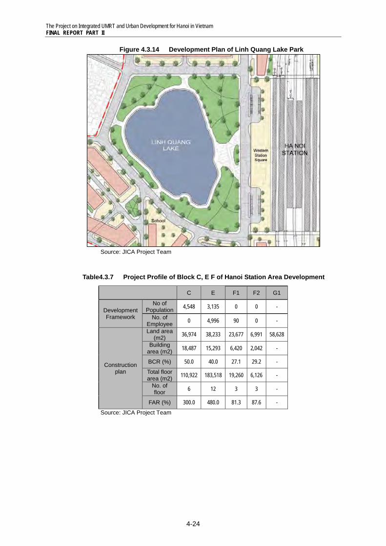
The Project on Integrated UMRT and Urban Development for Hanoi in Vietnam FINAL REPORT PART II
4-24
Figure 4.3.14 Development Plan of Linh Quang Lake Park
Source: JICA Project Team
Table4.3.7 Project Profile of Block C, E F of Hanoi Station Area Development
C E F1 F2 G1
Development Framework
No of Population 4,548 3,135 0 0 -
No. of Employee 0 4,996 90 0 -
Construction plan
Land area (m2) 36,974 38,233 23,677 6,991 58,628
Building area (m2) 18,487 15,293 6,420 2,042 -
BCR (%) 50.0 40.0 27.1 29.2 - Total floor area (m2) 110,922 183,518 19,260 6,126 -
No. of floor 6 12 3 3 -
FAR (%) 300.0 480.0 81.3 87.6 - Source: JICA Project Team
The Project on Integrated UMRT and Urban Development for Hanoi in Vietnam FINAL REPORT PART II
4-25
4.4 Social and Environmental Considerations
4.4.1 Current state of socio-environmental condition 456 Hanoi Station is located in a large land lot belonging to VNR. However, the development of the area around the station by widening existing roads, developing new roads, redeveloping residential areas, etc. may cause impacts to communities of the following 3 Communes: Van Mieu Commune, Van Chuong Commune, and Cua Nam Commune. Current living environment of the residential areas around the Linh Quang Lake in Van Chuong Commune located in the west of the station is deteriorated. Water in the Linh Quang Lake is severely polluted due to inflow of domestic wastewater from surrounding houses.
457 According to an environmental survey in 2007, noise levels in both day time and night time around the station are exceeding the allowable maximum limits. Concentration of NO2 in the ambient air is relatively high (180µg/m3) and has almost reached the allowable maximum level (200µg/m3). However, other concentrations of pollutant (dust, CO, SO2, HC) in ambient air are still lower than the allowable maximum limits.
Table4.4.1 Condition of Ambient Air Temper-
ature Humidity Dust CO SO2 NO2 HC
(°C) (%) (µg/m3) (µg/m3) (µg/m3) (µg/m3) (µg/m3) 23.9 72.9 90 11,890 230 180 6
Table4.4.2 Condition of Ambient Air Noise (day time: 6-18h) Noise (night time: 18-22h) Vibration
Leq Lamax L50 Leq Lamax L50 Laeq Lv (dB) (dB) (dB) (dB) (dB) (dB) (m/s2) (mm/s)
66.3 79.2 63.5 61.6 75.8 58.2 na na Note: HC: Hazardous substances in ambient air Airquality, noise, and vibration survey carried out by CEPT, in December 2006 Allowable maximum limit: Dust 300µg/m3, CO 30,000µg/m3, SO2 350µg/m3, NO2 200µg/m3,
HC 5,000µg/m3, Noise day time Leq 60dB, Noise night time Leq 55dB, Vibration Laeq 0.030m/s2
Source: EIA Report 2007, CEPT
458 According to results of the HIS (Household Interview Survey) conducted in 2005, sanitary toilet coverage in Cua Nam Commune is relatively low (74.5%). Van Chuong Commune in the west of the station has very low road area ratio (0.4%), and is incapable to response to disasters in case of emergency (emergency response capacity = 0.00). All Communes around the station are in severe lack of water area, park/open space, and green area.
The Project on Integrated UMRT and Urban Development for Hanoi in Vietnam FINAL REPORT PART II
4-26
Table4.4.3 Coverage of Public Service and Sanitation
Commune District Electri-
city
Piped water con-
nectivity
Toilet cover- age
Gas Tele- phone
Solid waste collec-
tion
Internet
(%) (%) (%) (%) (%) (%) (%) Van Mieu Dong Da 100.0 97.0 89.4 74.3 84.9 80.3 18.5Van Chuong Dong Da 100.0 97.9 90.4 86.2 94.7 98.9 17.0Cua Nam Hoan Kiem 100.0 100.0 74.5 87.2 96.4 87.3 18.2
Table4.4.4 Coverage of Urban Amenity and Disaster Prevention Capacity
Commune District
Urban Amenity and Disaster Prevention Capacity
Road area ratio
Flood vulner- ability index
House- hold with secure tenure
Emer- gency
response capacity
Water area per 1000 pop
Parks/ open
spaces per 1000
pop
Green area per 1000
pop
(%) (%) (m/ha) (ha) (ha) (ha) Van Mieu Dong Da 7.6 0.00 89.4 86.40 0.00 0.00 0.00Van Chuong Dong Da 0.4 0.00 100.0 0.00 0.18 0.00 0.00Cua Nam Hoan Kiem 20.8 0.00 98.2 138.00 0.00 0.01 0.01
Source: Household Interview Survey (HIS 2005), HAIDEP
459 Current living conditions of Van Chuong Commune in the west of the station are assessed as followings.
Table4.4.5 Living Condition Assessment of Van Chuong Commune Overall Evaluation with pre-identified indicators (objective indicators) show negative
unfavorable living condition of Van Chuong. People are moderately satisfied with the living condition. Both assessment show low score in amenity condition.
Convenience Road ratio is very low. People are highly dissatisfied with traffic situation. Public transport usage is very limited though service is provided.
Safety & Security
People are highly dissatisfied with safety/ security of the commune as its rank is the worst in Hanoi. Flood/ inundation is also a great threat for the residents. Traffic condition is very dangerous.
Health & Wellbeing
Hospital or medical facility is lacking. People are not satisfied with sanitary condition and air quality.
Amenity Amenity condition is very bad. There are almost no cultural facilities, parks, open spaces and green areas. As population density is high, people are dissatisfied with tranquility.
Capability Condition of telecommunication is highly satisfied by residents. Capability level of Van Chuong is at acceptable level and people are quite satisfied.
Source: Urban Karte, HAIDEP, 2005
4.4.2 Anticipated adverse impacts and mitigation measures 1) Anticipated adverse impacts
460 Overall, the station area development projects will result in environmental improvement and upgrading of quality of life of residents in the communities around the station, through improved road system, drainage system, solid waste collection and disposal system, public facilities, amenity facilities, community disaster preparedness and response capacity, etc. Living environment of the congested residential area in the west of the station (around the Linh Quang Lake) is expected to be significantly improved.
The Project on Integrated UMRT and Urban Development for Hanoi in Vietnam FINAL REPORT PART II
4-27
461 However, according to results of the environmental scoping, significant short-term adverse environmental impacts such as involuntary resettlement, sanitation, air pollution, water pollution, soil contamination, etc. might occur during pre-construction phase and construction phase if adequate mitigation measures are not taken.
Table4.4.6 Anticipated Environmental and Social Impacts Impact Description
Socio-economic environment Involuntary
resettlement A number of households in the west and in the north of the station would be relocated to make land for developing new roads, improving main access roads, redeveloping residential areas.
Sanitation Organic wastes and waste water generated from the construction sites may cause water-transmitted diseases and affect health of local citizens.
Pollution Air pollution Operation of construction machinery and transportation vehicles may cause
significant impact on ambient air quality of the localities. Water pollution Waste water from construction activities and discharged water from the stations
may cause deterioration of water quality of the vicinities. Soil
contamination Civil works and other construction activities during construction phase may cause contamination of soil.
Waste (including waste soil)
Solid wastes and sewage from the construction sites and from the stations may cause adverse impacts to soil and adjacent water bodies.
Accidents, traffic congestion
Traffic jam may be caused by construction vehicles on Le Duan Street and on the roads around the station during construction phase.
Radio wave interference
A number of houses near by the station may be affected by radio wave interference.
Sunshine shading
If the station is built as a multi-stories building, it may cause serious sunshine shading to its surrounding.
Source: JICA Project Team
462 Since the project will include the plans to build traffic works, urban center, business center, shopping mall, underground parking, etc. which require to resettle a significant number of residents (about 12,000 people), it will require to make an EIA (and a RAP) in accordance with Decree No. 21/3008/ND-CP.
2) Measures to mitigate impacts of land acquisition 463 During pre-construction phase, land acquisition and involuntary resettlement would be considered as the most significant impacts caused by the redevelopment projects. The planned development projects in the targeted development area would cause temporary or permanent relocation of a number of residents as following. Since project-affected households mentioned here would lose all or a great part of their residential land, they are considered as households to be relocated and resettled, temporarily or permanently.
Table 4.4.7 Scale of Land Acquisition and Project-affected Buildings by Minimum Project
ID Project Area of land to be
acquired Number of project -affected building
(m2) (buildings) S1 Hanoi Station Exclusion Exclusion S2 West ITF 9,430 30 S3 East ITF 0 10 R1 New west access road (w=24m) 22,406 314 R2 Widening of NH-1 (w=30m) 10,600 157
Total 42,436 511 Source: JICA Project Team 1) Number of project affected building includes existing building in SOE’s land
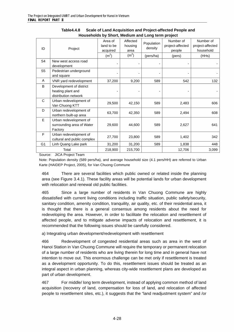
The Project on Integrated UMRT and Urban Development for Hanoi in Vietnam FINAL REPORT PART II
4-28
Table4.4.8 Scale of Land Acquisition and Project-affected People and Households by Short, Medium and Long term project
ID Project
Area of land to be acquired
Affected housing
area
Population density
Number of project-affected
people
Number of project-affected
household (m2) (m2) (pers/ha) (pers) (HHs)
S4 New west access road development
- - - - -
S5 Pedestrian underground and square
- - - - -
A VNR yard redevelopment 37,200 9,200 589 542 132B Development of district
heating plant and distribution network
- - - - -
C Urban redevelopment of Van Chuong KTT
29,500 42,150 589 2,483 606
D Urban redevelopment of northern built-up area
63,700 42,350 589 2,494 608
E Urban redevelopment of surrounding area of Water Factory
29,600 44,600 589 2,627 641
F Urban redevelopment of cultural and public complex
27,700 23,800 589 1,402 342
G1 Linh Quang Lake park 31,200 31,200 589 1,838 448Total 218,900 215,700 12,706 3,099
Source: JICA Project Team Note: Population density (589 pers/ha), and average household size (4.1 pers/HH) are referred to Urban Karte (HAIDEP Project, 2005), for Van Chuong Commune
464 There are several facilities which public owned or related inside the planning area (see Figure 3.4.1). These facility areas will be potential lands for urban development with relocation and renewal old public facilities.
465 Since a large number of residents in Van Chuong Commune are highly dissatisfied with current living conditions including traffic situation, public safety/security, sanitary condition, amenity condition, tranquility, air quality, etc. of their residential area, it is thought that there is a general consensus among residents about the need for redeveloping the area. However, in order to facilitate the relocation and resettlement of affected people, and to mitigate adverse impacts of relocation and resettlement, it is recommended that the following issues should be carefully considered.
a) Integrating urban development/redevelopment with resettlement
466 Redevelopment of congested residential areas such as area in the west of Hanoi Station in Van Chuong Commune will require the temporary or permanent relocation of a large number of residents who are living therein for long time and in general have not intention to move out. This enormous challenge can be met only if resettlement is treated as a development opportunity. To do this, resettlement issues should be treated as an integral aspect in urban planning, whereas city-wide resettlement plans are developed as part of urban development.
467 For middle/ long term development, instead of applying common method of land acquisition (recovery of land, compensation for loss of land, and relocation of affected people to resettlement sites, etc.), it suggests that the “land readjustment system” and /or
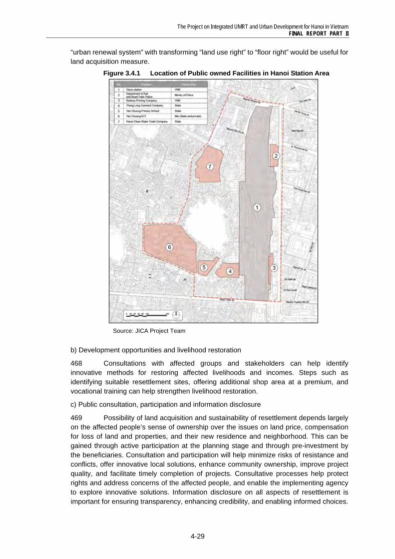
The Project on Integrated UMRT and Urban Development for Hanoi in Vietnam FINAL REPORT PART II
4-29
“urban renewal system” with transforming “land use right” to “floor right” would be useful for land acquisition measure.
Figure 3.4.1 Location of Public owned Facilities in Hanoi Station Area
Source: JICA Project Team
b) Development opportunities and livelihood restoration
468 Consultations with affected groups and stakeholders can help identify innovative methods for restoring affected livelihoods and incomes. Steps such as identifying suitable resettlement sites, offering additional shop area at a premium, and vocational training can help strengthen livelihood restoration.
c) Public consultation, participation and information disclosure
469 Possibility of land acquisition and sustainability of resettlement depends largely on the affected people’s sense of ownership over the issues on land price, compensation for loss of land and properties, and their new residence and neighborhood. This can be gained through active participation at the planning stage and through pre-investment by the beneficiaries. Consultation and participation will help minimize risks of resistance and conflicts, offer innovative local solutions, enhance community ownership, improve project quality, and facilitate timely completion of projects. Consultative processes help protect rights and address concerns of the affected people, and enable the implementing agency to explore innovative solutions. Information disclosure on all aspects of resettlement is important for ensuring transparency, enhancing credibility, and enabling informed choices.
The Project on Integrated UMRT and Urban Development for Hanoi in Vietnam FINAL REPORT PART II
4-30
The role of NGOs is useful for bringing in social mobilization and community development skills into the implementation process.
d) Grievance redress, independent monitoring and evaluation
470 Mechanism for grievance redress is essential for addressing the concerns of the affected people, especially those in the vulnerable category. It is essential to institute an independent monitoring mechanism in order to make the resettlement process transparent and accountable. External evaluation of resettlement impacts is a useful tool for assessing effectiveness of the implementation strategy.
3) Measures to mitigate impacts on sanitation
471 Contaminated drainage from the construction activities might pollute surface water quality around the project areas. Discharged water including sewage from the station facilities which has a significant number of passengers/users everyday may also deteriorate water quality. The drainage systems at the station facilities should be properly designed and maintained. In addition, it also needs to design the sewage facilities with a proper capacity, sewage pipes locating lower than the water supply pipes, and if necessary, preliminary treatment facilities. Discharged water quality from station facilities and surface and groundwater quality should also be monitored.
4) Measures to mitigate impacts of air pollution
472 Residents living in the area around the stations would be affected by air pollution and water pollution cause during construction phase.
473 During construction phase, the operation of construction machinery affects the ambient air quality by emitting pollutants. The magnitude of pollution will depend on the types of equipment and the operation time. Depending on wind conditions such as velocity and direction, emissions from construction equipment would affect the ambient air quality of neighboring areas. In addition, earth moving equipment during construction would also be a major source of dust emission. To mitigate impacts of air pollution, the following measures are recommended.
Periodically cleaning and watering the project sites. Secure distance between the construction machinery and construction site boundary
as much as possible. Using construction equipment and vehicles which comply with the latest regulations. Periodical inspection and maintenance of construction equipment and vehicles. De-concentrate construction activities. De-concentrate the flow of construction trucks. Use cover sheets for trucks carrying soil. Under the weather conditions such as strong wind, the construction activities are
suspended temporally for prevention of dust scattering. Training construction equipment drivers and truck drivers. Monitoring the air quality at the project site during all of the project cycles.
5) Measures to mitigate impacts of water pollution
474 During construction phase, if the contaminated drainage from the construction activities flows into surface water without proper treatment, it would pollute surface water quality around the project areas. During operation phase, discharged water including sewage from the station would deteriorate water quality as well. The following treatment measures should be prepared for discharged water from the project.
The Project on Integrated UMRT and Urban Development for Hanoi in Vietnam FINAL REPORT PART II
4-31
Build a small dike to prevent run-off water from construction sites. Consideration of separating construction areas with sheet piles. Mud should be dehydrated before discharged and reused as much as possible. Proper design and maintenance of drainage systems at station. The design includes a
sewage facility with a proper capacity, sewage pipes locating lower than the water supply pipes, and if necessary, preliminary treatment facilities.
Monitoring discharged water quality from stations, and surface water quality.
6) Measures to mitigate impacts of soil contamination
475 The construction of underground facilities may involve the excavation of soil. If the excavated soil is not treated appropriately, it may impact the environment through illegal dumping on private/public land, or pollution of the surrounding environment if the residual soil is contaminated by toxic materials. It is proposed that excavated soil should be carefully treated by the following measures.
Analysis of toxic materials of soil to be excavated. Utilization of excavated soil within the project. Contracting out treatment/dumping/recycling of residual soil. Covers and walls to preventing run off of stockpiled soil.
7) Measures to mitigate impacts of wastes
476 The construction activities in large areas around the station, etc. would generate a variety of wastes, including construction and demolition waste from the existing Hanoi Station and VNR facilities, the existing apartments, houses, etc.. Construction and demolition debris are composed of inert materials such as soil, rock, concrete, brick and asphalt etc., and non–inert materials including metal, timber, paper, glass and general garbage. The volume of the wastes to be generated is unknown at present time. However, at the design phase, waste volume and type should be assessed quantitatively. And during the construction phase, they should be reused and recycled as much as possible. With respect to the waste which cannot be reused and recycled, they would be contracted to and collected by an authorized company.
8) Measures to mitigate impacts of traffic congestion and accident
477 Accident and traffic congestion are also considered as potential adverse impacts. As the roadway will be narrow during the construction activities, traffic congestion by various transport means (vehicles, construction machines, buses, cars, motorbikes, etc.) and material yards (sand, stones, irons, cements, etc.) around project site are likely to happen very often, especially on the streets with heavy traffic flow on NH-1.
478 During construction phase, a traffic management plan should be implemented to prevent traffic congestion and accident due to construction activities. The plan should encompass several elements as follows:
Specification of time for vehicles for construction activities. Identification of roads blocked by construction activities. Arrange detouring roads. Providing preventive methods of traffic obstruction such as pre-cast concrete slabs for
cut and cover sections. Arrange by-pass roads for pedestrians. Deployment of personnel for traffic distribution direction and transporting at the night
time.
The Project on Integrated UMRT and Urban Development for Hanoi in Vietnam FINAL REPORT PART II
4-32
479 In addition, the following mitigation measures should be duly implemented by the contractors to mitigate impacts of traffic congestion and accidents:
Covering cut and cover sections with road deck plates. Prior notice of road occupation or closure by sign boards and mass media. Placement of personnel and sign boards for detouring. Secure paths and sign boards for people to access shops near construction areas. Prepare detailed construction plans to minimize areas and period of road occupation
or closure, and de-concentrate vehicle volume.
The Project on Integrated UMRT and Urban Development for Hanoi in Vietnam FINAL REPORT PART II
4-33
4.5 Project Implementation Mechanism
4.5.1 Issue on Implementation of Hanoi Station Area Development 480 Overall project implementation schedule is divided into four stages of minimum by the UMRT opening in 2017, short term, middle term and long term. Each project in station development area is scheduled on these four stages from the viewpoint of synergy with station opening and difficulty of implementation, especially, land acquisition. Implementation issue in each stage are explained as following;
1) Issue on minimum project implementation
481 Minimum project in Hanoi station development area include Station and related facilities development (S1, S2 and S3), road development (R1 and R2) and district heating plant development (F). These projects must be completed by the UMRT opening in 2017 and are required expeditiousness in project implementation. Main issues of minimum development are shown as followings;
• Smooth land acquisition • Securing financial resource • Utilization of SOE land • Role sharing among HPC and VNR
2) Issue on short -term project implementation
482 Short-term project in Hanoi station development area is urban development of the VNR owned land (A). This project is planned as commercial and business use and expected high synergy effect with station development. Therefore, it should be implemented to meet the time of UMRT opening as much as possible. For realization of this project, how to introduce private investment and clarify role sharing between private investor and VNR will be important.
• Encouragement of private investment • Role sharing between VNR and private investor
3) Issue on medium and long -term project implementation
483 Medium and long-term project in Hanoi station development area consists of five projects of urban redevelopment of northern built-up area (B), urban redevelopment of surrounding area of water factory (C), urban redevelopment of surroundings area of school (D), urban redevelopment of Van Chuong KTT (E). These projects aim urbanization with commercial and business use or public use and improvement of urban living condition in existing built-up area where had not been done any improvement until now. In these built-up area, land acquisition cost will be high and it will be taken long time for the negotiation with land right holder. For that reason, it is difficult to encourage private investment in built-up area at present. Main issues of medium and long-term development are shown as followings;
• High cost for land acquisition • Consensus building among residents • Resettlement measure • Encouragement of private investment • Role sharing among HPC and private investor
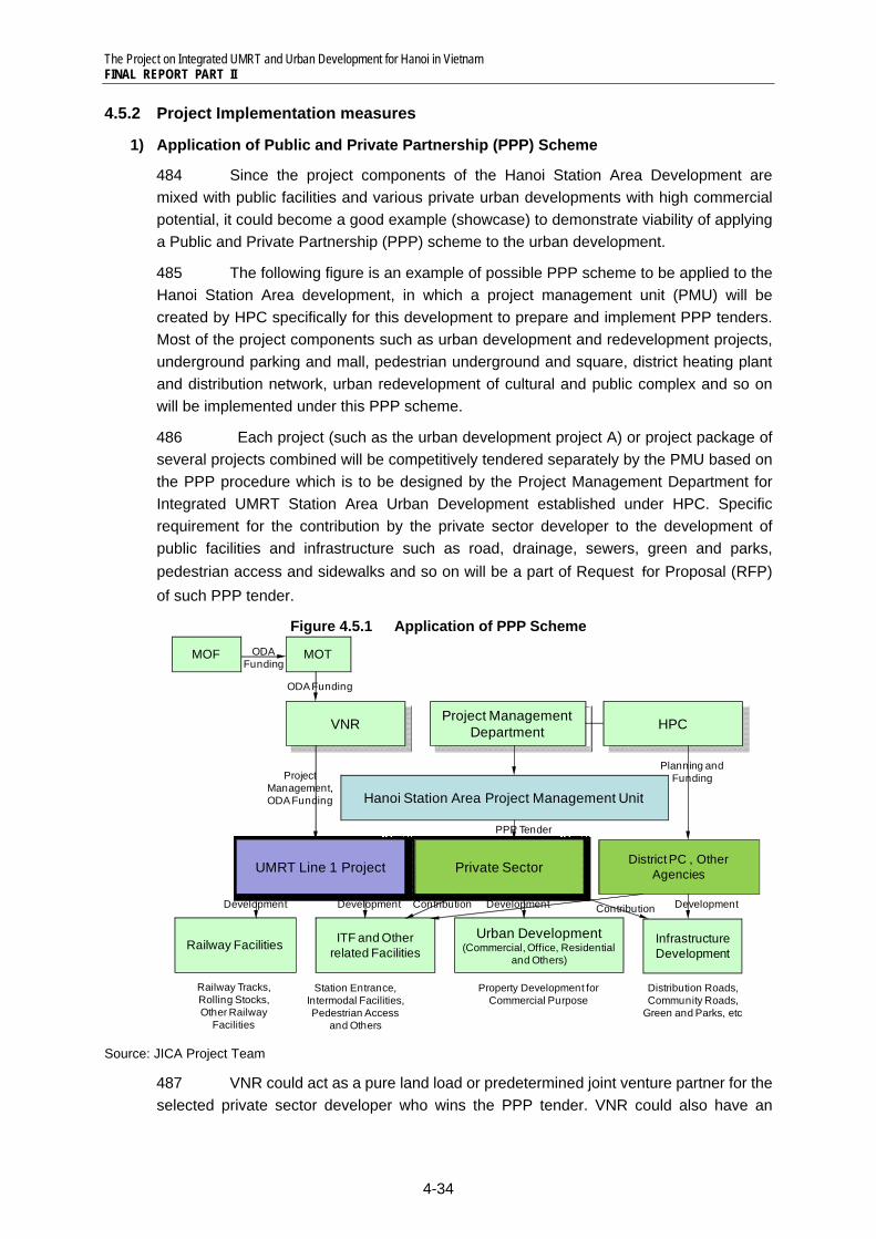
The Project on Integrated UMRT and Urban Development for Hanoi in Vietnam FINAL REPORT PART II
4-34
4.5.2 Project Implementation measures
1) Application of Public and Private Partnership (PPP) Scheme
484 Since the project components of the Hanoi Station Area Development are mixed with public facilities and various private urban developments with high commercial potential, it could become a good example (showcase) to demonstrate viability of applying a Public and Private Partnership (PPP) scheme to the urban development.
485 The following figure is an example of possible PPP scheme to be applied to the Hanoi Station Area development, in which a project management unit (PMU) will be created by HPC specifically for this development to prepare and implement PPP tenders. Most of the project components such as urban development and redevelopment projects, underground parking and mall, pedestrian underground and square, district heating plant and distribution network, urban redevelopment of cultural and public complex and so on will be implemented under this PPP scheme.
486 Each project (such as the urban development project A) or project package of several projects combined will be competitively tendered separately by the PMU based on the PPP procedure which is to be designed by the Project Management Department for Integrated UMRT Station Area Urban Development established under HPC. Specific requirement for the contribution by the private sector developer to the development of public facilities and infrastructure such as road, drainage, sewers, green and parks, pedestrian access and sidewalks and so on will be a part of Request for Proposal (RFP) of such PPP tender.
Figure 4.5.1 Application of PPP Scheme
Source: JICA Project Team
487 VNR could act as a pure land load or predetermined joint venture partner for the selected private sector developer who wins the PPP tender. VNR could also have an
Hanoi Station Area Project Management Unit
VNR
Railway Facilities ITF and Other related Facilities
Urban Development (Commercial, Office, Residential
and Others)
Railway Tracks, Rolling Stocks, Other Railway
Facilities
District PC , Other Agencies
Station Entrance, Intermodal Facilities, Pedestrian Access
and Others
Development Development
Project Management Department
UMRT Line 1 Project
MOF MOT
Infrastructure Development
Private Sector
Property Development for Commercial Purpose
Distribution Roads, Community Roads,
Green and Parks, etc
HPC
DevelopmentContribution Contribution Development
Project Management, ODA Funding
ODA Funding
ODA Funding
PPP Tender
Planning and Funding
The Project on Integrated UMRT and Urban Development for Hanoi in Vietnam FINAL REPORT PART II
4-35
option to develop its own land without applying this PPP scheme. HPC will be profited by gaining total control over the development and also by reducing its financial burden on its development of public facilities and infrastructure due to the contribution from the private sector developers through the implementation of this PPP scheme.
2) Station and Related Facilities Development (Project S1, S2, S3, S4, S5)
488 Station and related facilities development plan is composed of three project components of station building (S1), west ITF (S2) and east ITF (S3). ITF facilities are essential facilities for convenience and comfortableness for passengers and station users. This packaged project should be completed by the UMRT opening in 2017 and before the start of other urban development projects.
489 One of the significant projects of minimum development is to develop Intermodal Transfer Facilities (ITF) of east and west of Hanoi Station. While East ITF (S3) will be easily developed by VNR or HPC utilizing VNR land inside ROW, it is necessary to acquire private lands to develop West ITF (S2).
490 VNR will propose to extend alignment of present ROW to secure the necessary land for the West ITF. Since it has not been discussed and decided yet which will be an implementation body and financial resource for development and management of ITF, it is strongly proposed that VNR and HPC will discuss and clarify future ROW of VNR and implementation body for development of ITF facilities.
491 The JICA Project Team proposes that VNR will be in charge of station and related facility development, since ITF is a significant facility to improve accessibility for station users, and VNR will be main receiver for the benefit on the UMRT business by this package project.
492 Lands for station and related facilities are secured from existing Right of Way (ROW) of VNR and land recovery by VNR. Regarding relocation of existing enterprises, it is necessary to consider a resettlement plan to the place of surrounding UMRT station areas such as Gia Lam Station and Giap Bat Station in phase I of UMRT Line1.
493 To improve accessibility between Hanoi Station and UMRT Line3 Station which is underground of Tran Hung Dao Street, it is proposed to develop pedestrian underground mall under NH-1. There is a potential for commercial development which connects underground shopping mall and car parking in front of Hanoi Station. This project could be implemented under the PPP scheme subject to detailed analysis of financial viability of the project.
494 Implementation process of minimum development of Hanoi station area is shown as following Figure 4.5.2.
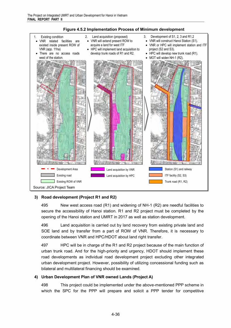
The Project on Integrated UMRT and Urban Development for Hanoi in Vietnam FINAL REPORT PART II
4-36
Figure 4.5.2 Implementation Process of Minimum development
3) Road development (Project R1 and R2)
495 New west access road (R1) and widening of NH-1 (R2) are needful facilities to secure the accessibility of Hanoi station. R1 and R2 project must be completed by the opening of the Hanoi station and UMRT in 2017 as well as station development.
496 Land acquisition is carried out by land recovery from existing private land and SOE land and by transfer from a part of ROW of VNR. Therefore, it is necessary to coordinate between VNR and HPC/HDOT about land right transfer.
497 HPC will be in charge of the R1 and R2 project because of the main function of urban trunk road. And for the high-priority and urgency, HDOT should implement these road developments as individual road development project excluding other integrated urban development project. However, possibility of utilizing concessional funding such as bilateral and multilateral financing should be examined.
4) Urban Development Plan of VNR owned Lands (Project A)
498 This project could be implemented under the above-mentioned PPP scheme in which the SPC for the PPP will prepare and solicit a PPP tender for competitive
S1 S2 S3
R1 R2
Line3 Station
3. Development of S1, 2, 3 and R1,2
VNR will construct Hanoi Station (S1).
VNR or HPC will implement station and ITF project (S2 and S3).
HPC will develop new trunk road (R1).
MOT will widen NH-1 (R2).
2. Land acquisition (proposed)
VNR will extend present ROW to acquire a land for west ITF
HPC will implement land acquisition to develop trunk roads of R1 and R2.
1. Existing condition
VNR related facilities are existed inside present ROW of VNR (app. 11ha)
There are no access roads
west of the station.
Source: JICA Project Team
Development Area
Existing road
Existing ROW of VNR
Land acquisition by VNR
Land acquisition by HPC
Station (S1) and railway
ITF facility (S2, S3)
Trunk road (R1, R2)
The Project on Integrated UMRT and Urban Development for Hanoi in Vietnam FINAL REPORT PART II
4-37
submission of development proposals from pre-qualified consortia of private sector developers and construction companies.
499 Urban development project of VNR owned land is planned as short-term project after station and related facilities and road development. Block A project consist mainly three components of (i) urban redevelopment for commercial and business, (ii) relocation and rehabilitation of existing Hanoi station and (iii) trunk road. This project will be a core project of Hanoi station area development. In ability to attract customers, it is expected that the land use of commercial and business will make the combined effect with UMRT station development.
4100 Land for the project will be provided by land recovery from private and a part of ROW of VNR. For private participation, land acquisition measures are proposed as followings;
(i) Private investor acquires land use right from private land and a part of VNR land
(ii) Private investor acquires land use right from private and VNR invested a part of ROW to private development.
4101 For the realization of both two measures, it is necessary to provide commercial use and activity to VNR’s authority. In addition, a SPC (special purpose company) could be created by VNR to implement the urban development project in the VNR owned lands.
4102 Urban redevelopment (UR) measure is useful for fair cost allocation and floor distribution as alternative development measure in a block which is composed of a mixture oft private land and VNR owned land. Model of Block A project of Hanoi station area is shown as following Figure 4.5.3.
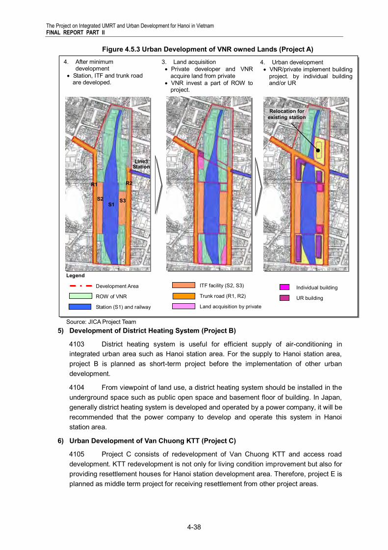
The Project on Integrated UMRT and Urban Development for Hanoi in Vietnam FINAL REPORT PART II
4-38
Figure 4.5.3 Urban Development of VNR owned Lands (Project A)
5) Development of District Heating System (Project B)
4103 District heating system is useful for efficient supply of air-conditioning in integrated urban area such as Hanoi station area. For the supply to Hanoi station area, project B is planned as short-term project before the implementation of other urban development.
4104 From viewpoint of land use, a district heating system should be installed in the underground space such as public open space and basement floor of building. In Japan, generally district heating system is developed and operated by a power company, it will be recommended that the power company to develop and operate this system in Hanoi station area.
6) Urban Development of Van Chuong KTT (Project C)
4105 Project C consists of redevelopment of Van Chuong KTT and access road development. KTT redevelopment is not only for living condition improvement but also for providing resettlement houses for Hanoi station development area. Therefore, project E is planned as middle term project for receiving resettlement from other project areas.
Individual building
UR building
Legend
Development Area
ROW of VNR
Station (S1) and railway
4. Urban development VNR/private implement building
project. by individual building and/or UR
ITF facility (S2, S3)
Trunk road (R1, R2)
Land acquisition by private
3. Land acquisition Private developer and VNR
acquire land from private VNR invest a part of ROW to
project.
4. After minimum development
Station, ITF and trunk road are developed.
Relocation for existing station
S1 S2 S3
R1 R2
Line3 Station
Source: JICA Project Team
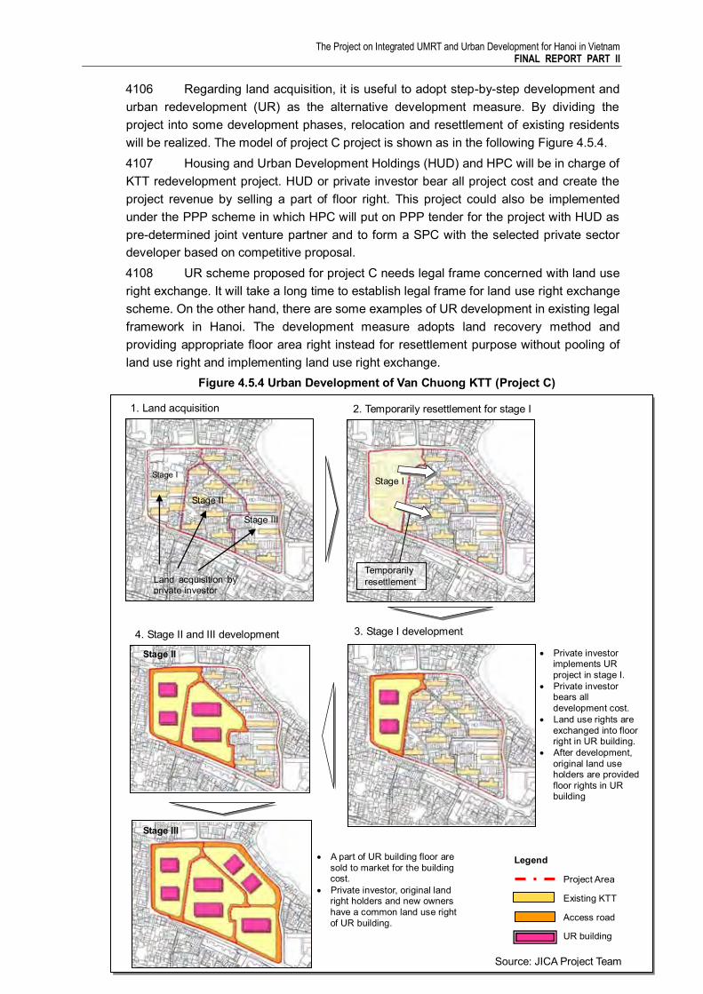
The Project on Integrated UMRT and Urban Development for Hanoi in Vietnam FINAL REPORT PART II
4-39
4106 Regarding land acquisition, it is useful to adopt step-by-step development and urban redevelopment (UR) as the alternative development measure. By dividing the project into some development phases, relocation and resettlement of existing residents will be realized. The model of project C project is shown as in the following Figure 4.5.4. 4107 Housing and Urban Development Holdings (HUD) and HPC will be in charge of KTT redevelopment project. HUD or private investor bear all project cost and create the project revenue by selling a part of floor right. This project could also be implemented under the PPP scheme in which HPC will put on PPP tender for the project with HUD as pre-determined joint venture partner and to form a SPC with the selected private sector developer based on competitive proposal. 4108 UR scheme proposed for project C needs legal frame concerned with land use right exchange. It will take a long time to establish legal frame for land use right exchange scheme. On the other hand, there are some examples of UR development in existing legal framework in Hanoi. The development measure adopts land recovery method and providing appropriate floor area right instead for resettlement purpose without pooling of land use right and implementing land use right exchange.
Figure 4.5.4 Urban Development of Van Chuong KTT (Project C)
1. Land acquisition 2. Temporarily resettlement for stage I
Stage I
Stage II
Stage III
Land acquisition by private investor
Stage I
Temporarily resettlement
3. Stage I development
Private investor implements UR project in stage I.
Private investor bears all development cost.
Land use rights are exchanged into floor right in UR building.
After development, original land use holders are provided floor rights in UR building
4. Stage II and III development
Stage II
Stage III
A part of UR building floor are sold to market for the building cost.
Private investor, original land right holders and new owners have a common land use right of UR building.
Source: JICA Project Team
Legend
Project Area
Existing KTT
Access road
UR building
Public facility
land (water works)
The Project on Integrated UMRT and Urban Development for Hanoi in Vietnam FINAL REPORT PART II
4-40
7) Urban Development Plan of Northern built-up area (Project D)
4109 Project D development is one of the priority areas from viewpoint of multiplier effect between station development and commercial and business development. However, in the land acquisition stage, it is expected to take a long time for consensus building among existing residents and land right holders. Therefore project D is planned as a long term project. 4110 For the project D development, it is useful to adopt alternative urban development measure of land readjustment (LR) and urban redevelopment (UR). Land re-plotting system of LR can consolidate land use right of private land, acquired land by private investor and VNR land to meet their demand. And LR also can make small lands combined into one building lot. Beside, UR can develop apartments and commercial buildings with participation of small land right holders. And UR provides adequate floor right exchanged from original land right and is useful for resettlement. 4111 However, LR and UR need legal scheme for land right protection through the project. In existing legal frame in Vietnam, there is no legal restriction for land right protection for LR and UR. It will take a long time to establish legal frame for these two alternative measures. Combination of LR and UR as a new development measure should be initiated by HPC with responsibility of developing required infrastructure to invite the private sector developers. Although implementation would involve new development measures based on new legal arrangement, this project could also be implemented under the PPP scheme. 4112 Regarding financial resource, it is expected to be invested by private sector. For the private participation, it is proposed to divide the project area into some blocks and to decide on a private investor by tender for each block.
8) Urban Development Plan of Surrounding Area of Water Factory (Project E)
4113 Project E is planned as a long term project because of the consideration of stepwise concept and difficulty of land acquisition. This project could be implemented under the similar PPP scheme mentioned above. 4114 Regarding land acquisition, it is necessary to relocate existing water factory to other place. After the relocation, the land will be used for seed land of the redevelopment project. It will provide opportunity of private participation and create land for infrastructure. In addition, land re-plotting system of LR can consolidate land use right of private land, acquired land by private investor to meet their demand. And LR also can make small lands combine into one building lot. On the other hands, UR can develop apartment and commercial building with participation from small land right holder and provides adequate floor right exchanged from original land right. 4115 However, LR and UR need legal scheme for land right protection through the project. In existing legal frame in Vietnam, there is no legal restriction for land right protection for LR and UR. It will take a long time to establish legal frame for these two alternative measures. 4116 Regarding financial resource, it is expected to invest by private. For the private participation, it is first priority to relocate of existing water factory. After project with LR and UR, Private investor gets a part of floor right and makes the profit to sell the floor right. The model of project E is shown as following Figure 4.5.5.
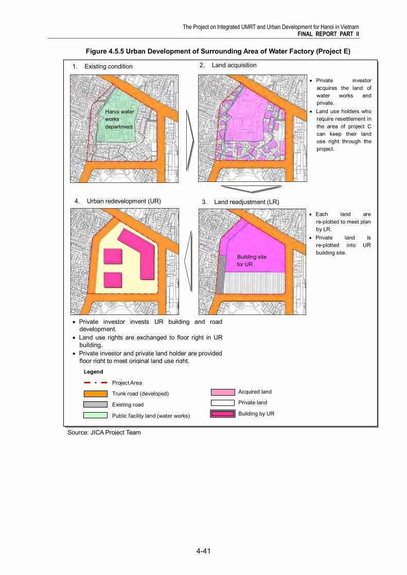
The Project on Integrated UMRT and Urban Development for Hanoi in Vietnam FINAL REPORT PART II
4-41
Figure 4.5.5 Urban Development of Surrounding Area of Water Factory (Project E)
Legend
Project Area
Trunk road (developed)
Existing road
Public facility land (water works)
1. Existing condition 2. Land acquisition
Private investor acquires the land of water works and private.
Land use holders who require resettlement in the area of project C can keep their land use right through the project.
3. Land readjustment (LR)
Each land are re-plotted to meet plan by LR.
Private land is re-plotted into UR building site.
4. Urban redevelopment (UR)
Acquired land
Private land
Building by UR
Private investor invests UR building and road development.
Land use rights are exchanged to floor right in UR building.
Private investor and private land holder are provided floor right to meet original land use right.
Hanoi water works department
Building site for UR
Source: JICA Project Team
The Project on Integrated UMRT and Urban Development for Hanoi in Vietnam FINAL REPORT PART II
4-42
9) Urban redevelopment of cultural and public complex (Project F)
4117 Project F consists of school rehabilitation, cultural hall development and road development and is planned as a long term project because of the difficulty of land acquisition.
4118 Land acquisition is implemented using land recovery by HPC. Although HPC will be in charge of this project implementation, it is possible to transfer management and operation to private company. This project could be implemented on the basis of BT (Built and Transfer) + O&M concession.
10) Development of Linh Quang Lake Park (Project G1)
4119 Linh Quang lake park project is to create healthy and comfortable urban environment in Hanoi station area. It is expected to make the combined effect with Hanoi station development area. However it will take a time for land acquisition. Project G1 is planned as a middle term project.
4120 This project will be implemented by HPC using public budget. And the land for development is acquired by land recovery. In the project implementation it is necessary to coordinate about right of water use of existing lake.
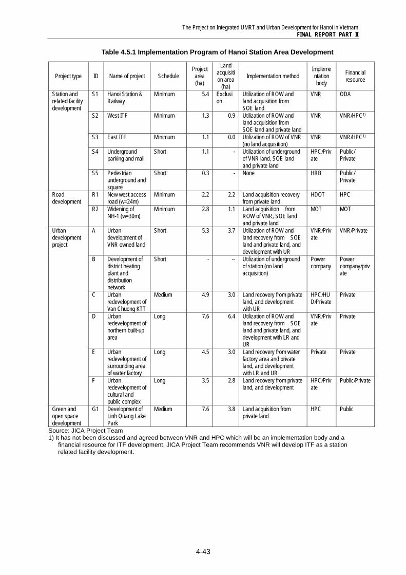
The Project on Integrated UMRT and Urban Development for Hanoi in Vietnam FINAL REPORT PART II
4-43
Table 4.5.1 Implementation Program of Hanoi Station Area Development
Project type ID Name of project Schedule Project area (ha)
Land acquisition area
(ha) Implementation method
Implementation body
Financial resource
Station and related facility development
S1 Hanoi Station & Railway
Minimum 5.4 Exclusion
Utilization of ROW and land acquisition from SOE land
VNR ODA
S2 West ITF Minimum 1.3 0.9 Utilization of ROW and land acquisition from SOE land and private land
VNR VNR/HPC1)
S3 East ITF Minimum 1.1 0.0 Utilization of ROW of VNR (no land acquisition)
VNR VNR/HPC1)
S4 Underground parking and mall
Short 1.1 - Utilization of underground of VNR land, SOE land and private land
HPC/Private
Public/ Private
S5 Pedestrian underground and square
Short 0.3 - None HRB Public/ Private
Road development
R1 New west access road (w=24m)
Minimum 2.2 2.2 Land acquisition recovery from private land
HDOT HPC
R2 Widening of NH-1 (w=30m)
Minimum 2.8 1.1 Land acquisition from ROW of VNR, SOE land and private land
MOT MOT
Urban development project
A Urban development of VNR owned land
Short 5.3 3.7 Utilization of ROW and land recovery from SOE land and private land, and development with UR
VNR/Private
VNR/Private
B Development of district heating plant and distribution network
Short - -- Utilization of underground of station (no land acquisition)
Power company
Power company/private
C Urban redevelopment of Van Chuong KTT
Medium 4.9 3.0 Land recovery from private land, and development with UR
HPC/HUD/Private
Private
D Urban redevelopment of northern built-up area
Long 7.6 6.4 Utilization of ROW and land recovery from SOE land and private land, and development with LR and UR
VNR/Private
Private
E Urban redevelopment of surrounding area of water factory
Long 4.5 3.0 Land recovery from water factory area and private land, and development with LR and UR
Private Private
F Urban redevelopment of cultural and public complex
Long 3.5 2.8 Land recovery from private land, and development
HPC/Private
Public/Private
Green and open space development
G1 Development of Linh Quang Lake Park
Medium 7.6 3.8 Land acquisition from private land
HPC Public
Source: JICA Project Team 1) It has not been discussed and agreed between VNR and HPC which will be an implementation body and a
financial resource for ITF development. JICA Project Team recommends VNR will develop ITF as a station related facility development.
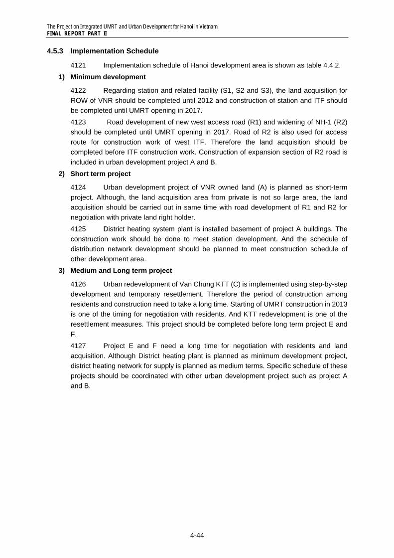
The Project on Integrated UMRT and Urban Development for Hanoi in Vietnam FINAL REPORT PART II
4-44
4.5.3 Implementation Schedule
4121 Implementation schedule of Hanoi development area is shown as table 4.4.2.
1) Minimum development
4122 Regarding station and related facility (S1, S2 and S3), the land acquisition for ROW of VNR should be completed until 2012 and construction of station and ITF should be completed until UMRT opening in 2017.
4123 Road development of new west access road (R1) and widening of NH-1 (R2) should be completed until UMRT opening in 2017. Road of R2 is also used for access route for construction work of west ITF. Therefore the land acquisition should be completed before ITF construction work. Construction of expansion section of R2 road is included in urban development project A and B.
2) Short term project
4124 Urban development project of VNR owned land (A) is planned as short-term project. Although, the land acquisition area from private is not so large area, the land acquisition should be carried out in same time with road development of R1 and R2 for negotiation with private land right holder. 4125 District heating system plant is installed basement of project A buildings. The construction work should be done to meet station development. And the schedule of distribution network development should be planned to meet construction schedule of other development area.
3) Medium and Long term project
4126 Urban redevelopment of Van Chung KTT (C) is implemented using step-by-step development and temporary resettlement. Therefore the period of construction among residents and construction need to take a long time. Starting of UMRT construction in 2013 is one of the timing for negotiation with residents. And KTT redevelopment is one of the resettlement measures. This project should be completed before long term project E and F. 4127 Project E and F need a long time for negotiation with residents and land acquisition. Although District heating plant is planned as minimum development project, district heating network for supply is planned as medium terms. Specific schedule of these projects should be coordinated with other urban development project such as project A and B.
The Project on Integrated UMRT and Urban Development for Hanoi in Vietnam FINAL REPORT PART II
4-45
Im
plem
enta
tion
Sch
edul
e
Long
2026
2025
2024
2023
2022
Med
ium
2021
2020
Sho
rt 2019
2018
Min
imum
2017
2016
2015
2014
2013
2012
2011
2010
Pro
jec
t ID
S1
S2
S3
S4
S5
R1
R2 A
B
C
D
E F G1
Nam
e of
Pro
ject
Han
oi S
tatio
n
Wes
t ITF
Eas
t ITF
Und
ergr
ound
par
king
an
d m
all
Ped
estri
an u
nder
grou
nd
and
squa
re
New
wes
t acc
ess
road
(w
=24m
)
Wid
enin
g of
NH
-1
(w=3
0m)
Urb
an d
evel
opm
ent o
f V
NR
ow
ned
land
Dev
elop
men
t of d
istri
ct
heat
ing
plan
t and
di
strib
utio
n ne
twor
k
Urb
an re
deve
lopm
ent o
f Va
n C
huon
g K
TT
Urb
an re
deve
lopm
ent o
f no
rther
n bu
ilt-u
p ar
ea
Urb
an re
deve
lopm
ent o
f su
rrou
ndin
g ar
ea o
f w
ater
fact
ory
Urb
an re
deve
lopm
ent
of c
ultu
ral a
nd p
ublic
co
mpl
ex
Dev
elop
men
t of L
inh
Qua
ng L
ake
Par
k
Pro
ject
Typ
e
Stat
ion
and
rela
ted
faci
lity
deve
lopm
ent
Roa
d de
velo
pmen
t
Urb
an d
evel
opm
ent
proj
ect
Gre
en a
nd o
pen
spac
e de
velo
pmen
t
Tabl
e 4.
5.2
Impl
emen
tatio
n Sc
hedu
le o
f Han
oi S
tatio
n A
rea
Dev
elop
men
t
UM
RT
Ope
ning
Pro
ject
App
rova
l,
Coo
rdin
atio
n
Land
Acq
uisi
tion,
C
onst
ruct
ion/
Bui
ldin
g
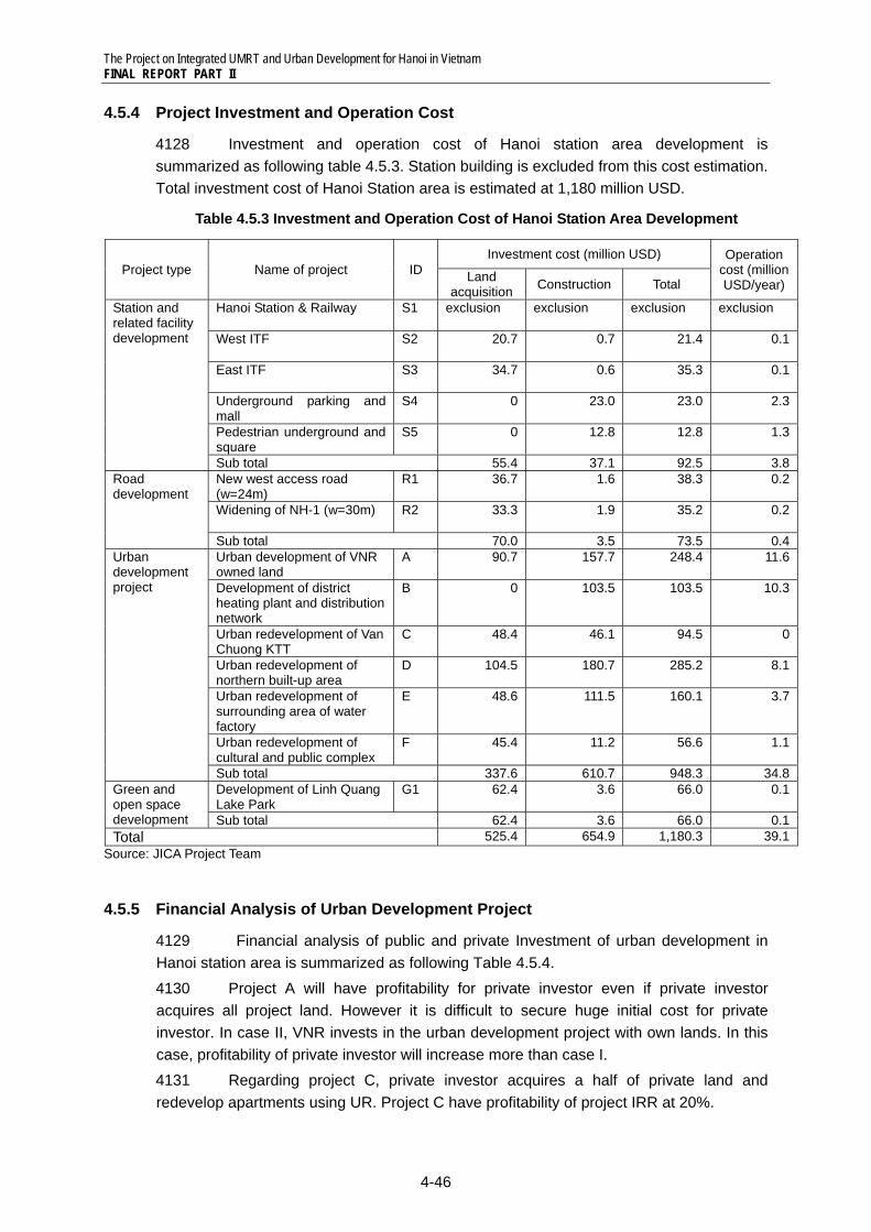
The Project on Integrated UMRT and Urban Development for Hanoi in Vietnam FINAL REPORT PART II
4-46
4.5.4 Project Investment and Operation Cost
4128 Investment and operation cost of Hanoi station area development is summarized as following table 4.5.3. Station building is excluded from this cost estimation. Total investment cost of Hanoi Station area is estimated at 1,180 million USD.
Table 4.5.3 Investment and Operation Cost of Hanoi Station Area Development
Project type Name of project ID Investment cost (million USD) Operation
cost (million USD/year)Land
acquisition Construction Total
Station and related facility development
Hanoi Station & Railway
S1 exclusion exclusion exclusion exclusion
West ITF
S2 20.7 0.7 21.4 0.1
East ITF
S3 34.7 0.6 35.3 0.1
Underground parking and mall
S4 0 23.0 23.0 2.3
Pedestrian underground and square
S5 0 12.8 12.8 1.3
Sub total 55.4 37.1 92.5 3.8Road development
New west access road (w=24m)
R1 36.7 1.6 38.3 0.2
Widening of NH-1 (w=30m)
R2 33.3 1.9 35.2 0.2
Sub total 70.0 3.5 73.5 0.4Urban development project
Urban development of VNR owned land
A 90.7 157.7 248.4 11.6
Development of district heating plant and distribution network
B 0 103.5 103.5 10.3
Urban redevelopment of Van Chuong KTT
C 48.4 46.1 94.5 0
Urban redevelopment of northern built-up area
D 104.5 180.7 285.2 8.1
Urban redevelopment of surrounding area of water factory
E 48.6 111.5 160.1 3.7
Urban redevelopment of cultural and public complex
F 45.4 11.2 56.6 1.1
Sub total 337.6 610.7 948.3 34.8Green and open space development
Development of Linh Quang Lake Park
G1 62.4 3.6 66.0 0.1
Sub total 62.4 3.6 66.0 0.1Total 525.4 654.9 1,180.3 39.1
Source: JICA Project Team
4.5.5 Financial Analysis of Urban Development Project
4129 Financial analysis of public and private Investment of urban development in Hanoi station area is summarized as following Table 4.5.4. 4130 Project A will have profitability for private investor even if private investor acquires all project land. However it is difficult to secure huge initial cost for private investor. In case II, VNR invests in the urban development project with own lands. In this case, profitability of private investor will increase more than case I. 4131 Regarding project C, private investor acquires a half of private land and redevelop apartments using UR. Project C have profitability of project IRR at 20%.
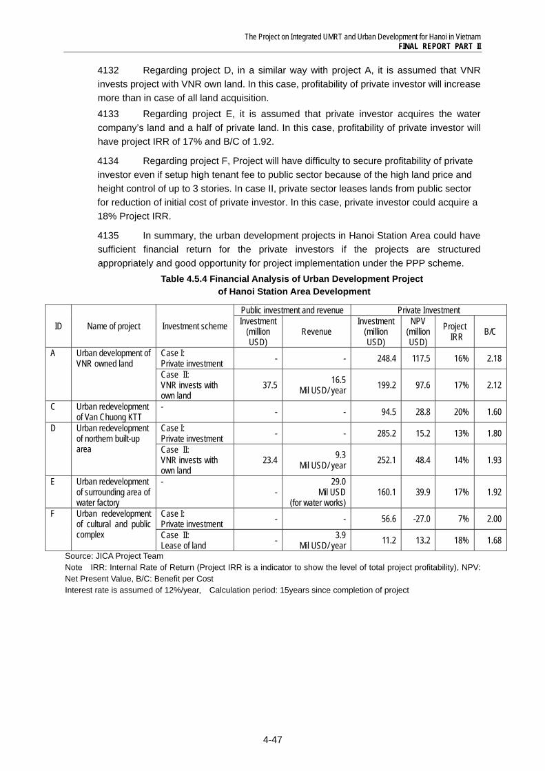
The Project on Integrated UMRT and Urban Development for Hanoi in Vietnam FINAL REPORT PART II
4-47
4132 Regarding project D, in a similar way with project A, it is assumed that VNR invests project with VNR own land. In this case, profitability of private investor will increase more than in case of all land acquisition. 4133 Regarding project E, it is assumed that private investor acquires the water company’s land and a half of private land. In this case, profitability of private investor will have project IRR of 17% and B/C of 1.92.
4134 Regarding project F, Project will have difficulty to secure profitability of private investor even if setup high tenant fee to public sector because of the high land price and height control of up to 3 stories. In case II, private sector leases lands from public sector for reduction of initial cost of private investor. In this case, private investor could acquire a 18% Project IRR.
4135 In summary, the urban development projects in Hanoi Station Area could have sufficient financial return for the private investors if the projects are structured appropriately and good opportunity for project implementation under the PPP scheme.
Table 4.5.4 Financial Analysis of Urban Development Project of Hanoi Station Area Development
ID Name of project Investment scheme
Public investment and revenue Private Investment Investment
(million USD)
Revenue Investment
(million USD)
NPV (million USD)
Project IRR B/C
A Urban development of VNR owned land
Case I: Private investment - - 248.4 117.5 16% 2.18
Case II: VNR invests with own land
37.5 16.5 Mil USD/ year 199.2 97.6 17% 2.12
C Urban redevelopment of Van Chuong KTT
- - - 94.5 28.8 20% 1.60
D Urban redevelopment of northern built-up area
Case I: Private investment - - 285.2 15.2 13% 1.80
Case II: VNR invests with own land
23.4 9.3 Mil USD/ year 252.1 48.4 14% 1.93
E Urban redevelopment of surrounding area of water factory
- -
29.0 Mil USD
(for water works) 160.1 39.9 17% 1.92
F Urban redevelopment of cultural and public complex
Case I: Private investment - - 56.6 -27.0 7% 2.00
Case II: Lease of land - 3.9
Mil USD/ year 11.2 13.2 18% 1.68 Source: JICA Project Team Note IRR: Internal Rate of Return (Project IRR is a indicator to show the level of total project profitability), NPV: Net Present Value, B/C: Benefit per Cost Interest rate is assumed of 12%/year, Calculation period: 15years since completion of project
The Project on Integrated UMRT and Urban Development for Hanoi in Vietnam FINAL REPORT PART II
4-48