Embed Size (px)
Citation preview
910100
1SUPERVISOR’S USE ONLY
9 1 0 1 0
© New Zealand Qualifications Authority, 2014. All rights reserved.No part of this publication may be reproduced by any means without the prior permission of the New Zealand Qualifications Authority.
Level 1 Geography, 201491010 Apply concepts and basic geographic skills to demonstrate understanding of a given environment
9.30 am Monday 17 November 2014 Credits: Four
Achievement Achievement with Merit Achievement with ExcellenceApply concepts and basic geographic skills to demonstrate understanding of a given environment.
Apply concepts and basic geographic skills to demonstrate in-depth understanding of a given environment.
Apply concepts and basic geographic skills to demonstrate comprehensive understanding of a given environment.
Check that the National Student Number (NSN) on your admission slip is the same as the number at the top of this page.
You should attempt ALL the questions in this booklet.
Pull out Resource Booklet 91010R from the centre of this booklet.
If you need more room for any answer, use the extra space provided at the back of this booklet.
Check that this booklet has pages 2 – 12 in the correct order and that none of these pages is blank.
YOU MUST HAND THIS BOOKLET TO THE SUPERVISOR AT THE END OF THE EXAMINATION.
ASSESSOR’S USE ONLY
TOTAL
Note: The place names, ʻWanganui’ and ʻWhanganui’, were both recognised as official names of the city following an amendment passed in parliament in 2012, and as such, both spellings have been listed throughout this exam booklet. (The river name remains Whanganui).
QUESTION ONE: MAP AND RESOURCE INTERPRETATION
Refer to Resources A–D on pages 3 and 4 of the resource booklet, as well as Resource F on pages 6 and 7, when answering (a).
(a) Write a geographic description to show the relationship between the City of Wanganui / Whanganui and the Whanganui River.
Include specific evidence from Resources A–D and Resource F to support your answer.
Refer to Resource F on pages 6 and 7 of the resource booklet when answering (b)–(d).
(b) (i) Calculate the length of the main runway at Wanganui / Whanganui Airport.
(ii) Name the compass directions of the main airport runway.
From: to:
(iii) Provide the numbers of the two state highways that meet at the roundabout at GR 752759.
State Highways: and:
(c) Give the area reference (AR) for the suburb of Springvale (north-west of the Racecourse) from the map.
AR:
2
Geography 91010, 2014
ASSESSOR’S USE ONLY
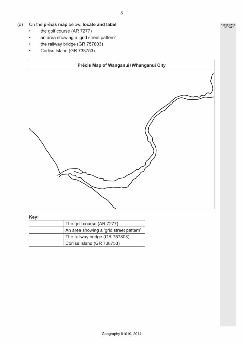
(d) On the précis map below, locate and label:• the golf course (AR 7277)• an area showing a ‘grid street pattern’• the railway bridge (GR 757803)• Corliss Island (GR 738753).
Précis Map of Wanganui / Whanganui City
Key:
The golf course (AR 7277)An area showing a ‘grid street pattern’The railway bridge (GR 757803)Corliss Island (GR 738753)
3
Geography 91010, 2014
ASSESSOR’S USE ONLY
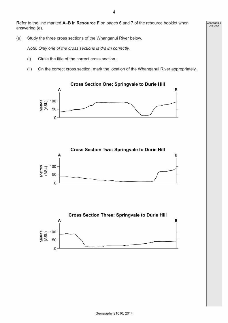
Refer to the line marked A–B in Resource F on pages 6 and 7 of the resource booklet when answering (e).
(e) Study the three cross sections of the Whanganui River below.
Note: Only one of the cross sections is drawn correctly.
(i) Circle the title of the correct cross section.
(ii) On the correct cross section, mark the location of the Whanganui River appropriately.
A BCross Section One: Springvale to Durie Hill
0
50
100
Metres
(ASL)
A BCross Section Two: Springvale to Durie Hill
0
50
100
Metres
(ASL)
A BCross Section Three: Springvale to Durie Hill
0
50
100
Metres
(ASL)
4
Geography 91010, 2014
ASSESSOR’S USE ONLY
Read the following geographic concept and refer to it, as well as Resource F on pages 6 and 7 of the resource booklet when answering (f).
Geographic Concept
Environments may be natural and / or cultural. They have particular characteristics and features which can be the result of natural and / or cultural processes. The particular characteristics of an environment may be similar to and / or different from another.
(f) Fully explain how living on the south-east side of the Whanganui River would be quite different to living on the north-west side.
Include specific evidence from the geographic concept and Resource F, as well as from the other resources, to support your answer.
5
Geography 91010, 2014
ASSESSOR’S USE ONLY
QUESTION TWO: GRAPHS AND STATISTICS
Refer to Resource E on page 5 of the resource booklet when answering (a).
(a) Use the information about opening hours to calculate the number of hours the Durie Hill Elevator is open during the weekend.
hours
Refer to Resources G–J on page 8 of the resource booklet when answering (b)–(d).
(b) The statistics shown in Resources G–J can each be represented on one of the following four different types of graphs:(1) A line graph(2) A percentage bar graph(3) A histogram(4) A scatter graph.
Complete the table below by matching the statistics in Resources G–J with the correct graph type from the list above.
Note: Use each type of graph only once.
Statistics Graph TypePopulation of Wanganui / Whanganui
Getting to Wanganui / Whanganui (time and distance)Average rainfall statistics for the Wanganui / Whanganui areaReferendum results on the spelling of Wanganui vs Whanganui
(c) (i) Which season in 2012 had the most rainfall?
(ii) What is the total rainfall for the season you have named in (c) (i)?
mm
6
Geography 91010, 2014
ASSESSOR’S USE ONLY
(d) Fully explain the changes to Wanganui / Whanganui’s population growth from 1966 to 2006.
Include appropriate statistics to support your answer.
7
Geography 91010, 2014
ASSESSOR’S USE ONLY
Question Two continues on the next page
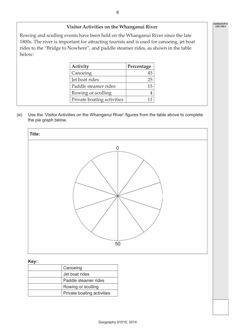
Visitor Activities on the Whanganui River
Rowing and sculling events have been held on the Whanganui River since the late 1800s. The river is important for attracting tourists and is used for canoeing, jet boat rides to the “Bridge to Nowhere”, and paddle steamer rides, as shown in the table below:
Activity PercentageCanoeing 45Jet boat rides 25Paddle steamer rides 15Rowing or sculling 4Private boating activities 11
(e) Use the ‘Visitor Activities on the Whanganui River’ figures from the table above to complete the pie graph below.
Title:
0
50
Key:CanoeingJet boat ridesPaddle steamer ridesRowing or scullingPrivate boating activities
8
Geography 91010, 2014
ASSESSOR’S USE ONLY
QUESTION THREE: APPLICATION OF GEOGRAPHIC CONCEPTS
Read the following geographic concept and refer to it, as well as ALL of the resources on pages 3–9 of the resource booklet when answering (a).
Geographic Concept
Change involves any alteration to the natural or cultural environment. Change can be spatial and / or temporal. Change is a normal process in both natural and cultural environments. It occurs at varying rates, at different times, and in different places. Some changes are predictable, recurrent, or cyclic, while others are unpredictable or erratic. Change can bring about further change.
(a) Fully explain how the concept of change can be applied to Wanganui / Whanganui city and to the Whanganui River.
Include specific evidence from the geographic concept and the resources to support your answer.
9
Geography 91010, 2014
ASSESSOR’S USE ONLY
Read the following Māori concept and refer to it, as well as ALL of the resources on pages 3–9 of the resource booklet when answering (b).
Māori Concept
Taonga is a resource either physical or cultural that can be found in the environment (including features within the environment, eg lakes, mountains, rivers, also including people, te reo, whakapapa, etc). All taonga are tapu (tapu is the state of being sacred or special).
(b) Fully explain how the concept of taonga can be applied to the Whanganui River.
Include specific evidence from the Māori concept and the resources to support your answer.
10
Geography 91010, 2014
ASSESSOR’S USE ONLY
11
Geography 91010, 2014
ASSESSOR’S USE ONLY
QUESTION NUMBER
Extra space if required.Write the question number(s) if applicable.
91
01
012
Geography 91010, 2014
ASSESSOR’S USE ONLY
QUESTION NUMBER
Extra space if required.Write the question number(s) if applicable.