Embed Size (px)
Citation preview
i
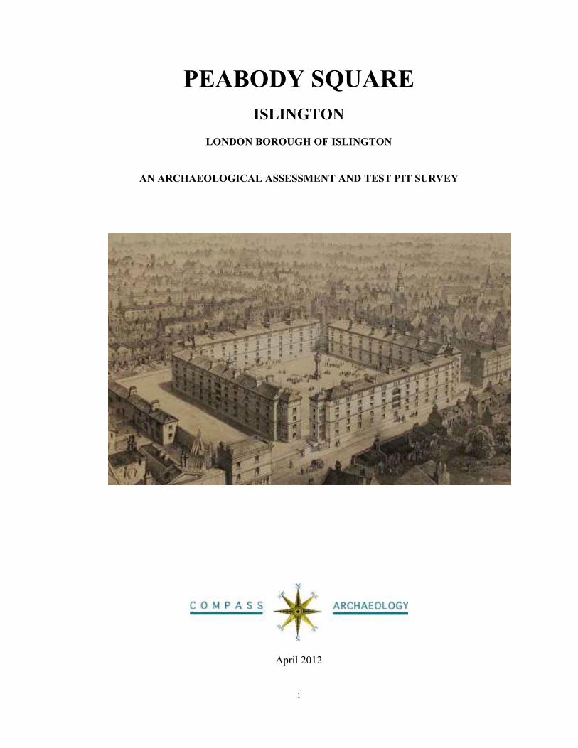
PEABODY SQUARE
ISLINGTON
LONDON BOROUGH OF ISLINGTON
AN ARCHAEOLOGICAL ASSESSMENT AND TEST PIT SURVEY
April 2012
ii
PEABODY SQUARE
ISLINGTON
LONDON BOROUGH OF ISLINGTON
AN ARCHAEOLOGICAL ASSESSMENT AND TEST PIT SURVEY
SITE CENTRE NGR: TQ 32080 83969
Block A: TQ 32089 83991
Block B: TQ 32057 83975
Block C: TQ 320105 83964
Block D: TQ 32072 83946
Block E: TQ 32041 83944
Blocks F to I: TQ 32074 83944
COMPASS ARCHAEOLOGY LIMITED
5-7 SOUTHWARK STREET
LONDON SE1 1RQ
Telephone: 020 7403 9660
e-mail: [email protected]
April 2012
© Compass Archaeology Ltd.
iii
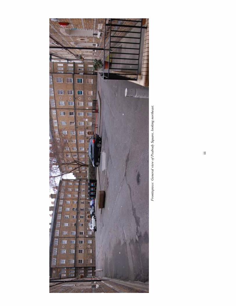
Frontispiece: General view of Peabody Square, looking northeast.
iv
Executive Summary
This report provides an archaeological assessment of the site of the Grade II Peabody Islington
estate, in advance of general site refurbishment works to be carried out by Peabody, as part of their IMPROVE initiative. The objective of the report was to discover what evidence survived of
the original 1860s landscaping materials, street furniture and associated surfaces and features,
in order to incorporate historically appropriate designs into the IMPROVE works. The
assessment has been written prior to the submission of a planning application.
The Islington estate was built in 1864-65, to the designs of Henry Astley Darbishire (1825-99),
as Model Dwellings for Peabody and was listed as Grade II in 1996. This was the first Peabody
estate to be arranged in, what was to become, a standard design across London, and the most elaborate. The Islington estate is considered by English Heritage to be of ‘seminal historic
importance’, being the earliest surviving intact example of later 19th century Peabody social
housing (Barson and O’Rourke, 2001).
The report has noted the survival of some heritage features dating to the first construction of the Islington estate by Darbishire in 1865. This includes the general layout of the Square and
western entrance from Greenman Street, and Peabody Yard and House (predating 1865 with the
original cobbled surface). Remains of the original York stone inner kerb within the Square were
also noted (although largely hidden under the tarmac), and a small section of walling at the
western entrance from Greenman Street. Other early heritage features have been lost; these
include the eastern entrance from Greenman Street, which is now blocked off and completely
remodelled, and the gates, railings, and layout of the western entrance. It is possible that the
eastern entrance from Greenman Street, with the stairs, could be re-instated to recapture some of
the original layout and feel of the Estate. Elements such as the linear concrete gulleys running
adjacent to the housing blocks and some of the serpentine gulleys have been revealed to be of later date, i.e. after 1885.
As part of this report, six investigative trial trenches were excavated across the Square in order
to determine the nature of the original surfacing. The investigation revealed that the early
surfacing appears to have been yellow/orange gravel (mirroring and complementing the yellow
brick of the blocks) in the interior recreational area of the Square, with originally gravel and
then later a surrounding roadway of a tar and black gravel conglomerate; the two areas were
divided by a kerb of York stone. At a later stage the whole Square was surfaced with tar
(probably Hobman’s Tar-Paving as mentioned by Darbishire) and then again at a further phase
the exterior roadway area of the Square was laid with granolithic paving (thought to have been
inserted in the early 20th century, the underlying tar-paving being broken up to form a bed for
this surface). There was unfortunately no evidence surviving for the layout of the exact centre of
the Square, or for the fire hydrant, which is shown on the pre-1885 drainage plan. Some heritage
features associated with the 1885 extension of the Estate were also noted. This includes the layout of the Dibden Street entrance and the gate piers here (although not the gate itself), the
small wall running along Dibden Street with the remnants of railings which were once positioned
on top of this, a single granite bollard on the north-west corner of Block F, and the steps between
Blocks C and D. Other features were noted which are associated with later changes made to the
Estate. This includes, most noticeably, the pram sheds, Porter’s workshop and coal stores added
by Victor Wilkins in 1915. The report identified a modern garage building on the site at the rear
Block D, which is not in keeping with the setting of the Listed Buildings and should be removed
as part of the IMPROVE works. This garage stands alongside the Porter’s Workshop, a lean-to
structure dating from Victor Wilkins 1915 work, which could also possibly be removed as part of the IMPROVE works if this was deemed acceptable by the LPA .
The heritage features have been identified in order to see where originally elements can be re-instated, in the new works, to be in keeping with the historic nature of the Estate and its Listed
status.
v
Contents page
1 Introduction 1
2 Acknowledgements 2
3 Site Location 3
4 Objectives of the IMPROVE programme and this assessment report 4
5 Archaeological assessments and planning 5
6 George Peabody and ‘Peabody’ 6
7 Henry Astley Darbishire and the Peabody estates 8
8 Archaeological and Historical Background to the Islington Site 13
9 The Current Site: Walkover Survey and On-Site Investigations 24
10 The Original Estate – 1865 24
11 On-site Investigations - the six test pits 48
12 The 1885 Extension 57
13 Victor Wilkins’ Changes 1915 63
14 Post-1915 Changes 66
15 Conclusions and Recommendations 67
16 Sources Consulted and Bibliography 70
vi
List of Figures page
Front cover: Panoramic photograph of Peabody Square today.
1 Site location 2
2 Site Layout 3
3 The site with some sketched indications of a possible proposal 5
4 George Peabody (1795-1869) by James Reid Lambdin (1807-1889) 6
5 George Peabody’s signature at Islington estate 1866. 7
6 Two extracts from the Builder. 8
7 The first Peabody estate in Spitalfields built 1864 9
8 The second Peabody estate at Islington 9
9 Peabody Square, Blackfriars built 1871. 10
10 Photograph of the Pimlico Peabody estate built 1876-8. 10
11 Peabody Buildings at Great Wild Street 11
12 Peabody Buildings Westminster 11
13 Peabody Buildings at Herbrand Street built 1885 12
14 An engraving of ‘Ward’s Place’ 13
15 Extract from Greenwood’s Map of c.1827 14
16 Extract from the Islington Parish Map, 1862. 15
17 Peabody Square Islington, 1860s 16
18 H A Darbishire’s internal layout for Blocks A to D at Islington. 16
19 A post card view of Peabody Square, Islington, 17
20 Detail of the OS First Edition Map, 1871 19
21 The Metropolis Improvement Scheme 1878 20
22 Ordnance Survey Second Edition 1894-6 20
23 Victor Wilkins’ plans and elevations for works to Peabody House 1936
vii
24 Bomb Damage Map 1939-1945 22
25 F.E.F. Atkinson’s plans for Peabody House, 1964 23
26 Peabody plan for Peabody House, 1983 23
27 Peabody Square Islington 25
28 Peabody Buildings Westminster 26
29 Extract from the 1871 OS Map 26
30 Photograph of the original sign on Block B 26
31 Photograph of the western entrance from Greenman Street today 27
32 Photograph of the later wall and railings 27
33 Extract from the Drainage Plan, with the curved wall circled 28
34 The small section of curved wall and gate pier 28
35 Close-up photograph of the small section of original curved wall 28
36 Extract from the 1871 OS Map 29
37 Extract dated to 1860, showing the eastern entrance from Greenman Street 29
38 Photograph of the eastern entrance 30
39 Photograph of the eastern entrance from Greenman Street 30
40 Extract from the Drainage Plan 31
41 Photograph of the two serpentine gulleys today 31
42 Panoramic photograph of the Peabody Square 32
43 Peabody Square Islington 32
44 Peabody Square 33
45 Photograph of Peabody Square today 34
46 Extract from OS 1871 Map 35
47 Photograph showing part of the remaining original kerb. 36
viii
48 Photograph of part of the remaining original kerb. 36
49 Close-up photograph of the kerb. 37
50 Photograph of the tarmac surface today 38
51 Close-up photograph of the granolithic paving today. 38
52 Drainage Plan. 39
53 Photograph of Block B. 40
54 Close-up photograph of one of the concrete linear gulleys today. 40
55 Photograph of the serpentine gulleys between Blocks A and C. 41
56 Close-up photograph of the serpentine gulley. 41
57 Photograph of the tarmac impression of the serpentine gulley 42
58 Photograph of the southern end of Block B. 42
59-60 Extract from the 1871 OS Map 43
61 Photograph of the area behind Block B today. 44
62 Photograph of the area behind Block C today 44
63 Extract from the 1871 OS Map, with ‘Peabody Court’ outlined. 45
64 Photograph of the entrance to Peabody Yard from Greenman Street. 46
65 Photograph of the iron gates (not original) leading into Peabody Yard. 46
66 Photograph of the base of the gate leading into Peabody Yard. 46
67 Photograph of the gate into Peabody Yard 47
68 Photograph of Peabody Yard today. 47
69 Photograph of some of the original cobbles in Peabody Yard, 48
70 Panoramic view showing test pit locations 49
71 General Plan showing six test pits 49
72-78 General views of the six test pits 50-57
79 Extract from the 1895-6 OS Map, with the new entrance circled. 58
ix
80 Photograph of the Dibden Street entrance today. 58
81 Photograph of the small wall running along Dibden Street frontage 59
82 Photograph of the small wall along Dibden Street 59
83 Photograph of the area between Blocks D and F-I today 60
84 Photograph of the area between Block D and F-I today 61
85 Photograph of the original granite bollard 61
86 Photograph of the steps between Blocks C and D today 62
87 Close-up photograph of the steps between Blocks C and D today. 62
88 Extract from the 1894-5 OS Map 62
89 Photograph of the pram sheds behind Block B 63
90 Photograph of the pram sheds 64
91 Photograph of the single-storey coal stores 64
92 Photograph of the single-storey coal store 65
93-94 Photographs of the Porter’s workshop and modern garage 65-67
95 Photograph of Dibden House today, taken from Dibden Street. 67
1
1. Introduction
1.1 This report details the results of an archaeological assessment and test pit survey at
the Grade II listed Islington estate, in advance of general site refurbishment works to
be carried out by Peabody as part of their IMPROVE initiative. The objective of this
report is to discover what evidence survives of the original landscaping materials,
street furniture and associated surfaces and features at Islington, in order to
incorporate historically appropriate designs into the IMPROVE works. The
assessment has been written prior to the submission of a planning application.
1.2 The Islington estate was built in 1864-65, to the designs of Henry Astley Darbishire
(1825-99), as model dwellings for the ‘Peabody Trust’ (as it was then known) and
was listed as Grade II in 1996. The listing includes all the buildings, coal stores, pram
stores and Peabody Yard. This was the first Peabody estate to be arranged in what was
to become a standard design across London. The Islington estate is considered by
English Heritage to be of ‘seminal historic importance’, being the earliest surviving
intact example of later 19th century Peabody social housing (Barson and O’Rourke,
2001).
1.3 In 2001 English Heritage produced a pamphlet entitled ‘The Peabody estates.
Conservation Guidelines’, which was a very detailed guide to the Islington estate
drawing together all the primary research archives and it is recommended that this
assessment report be read in association with the pamphlet (Barson and O’Rourke,
2001). This assessment report uses much of the data from the 2001 report, with some
additional research material that has recently come to light. I am extremely grateful to
Susie Barson of English Heritage and Christine Wagg, archivist for Peabody, for their
support with this assessment and for taking time to discuss the implications of the
recent findings.
1.4 Despite detailed searches of the available archives, there is little evidence for the
original drawings by Henry Darbishire, and none for the Islington estate survive in the
Peabody Archives at the London Metropolitan Archive, or for any of the Peabody
buildings at the RIBA British Architectural Library. Christine Wagg notes that Henry
Darbishire was an independent architect working from his private practice at 4
Trafalgar Square, so unfortunately his plans were never deposited with Peabody.
1.5 Nonetheless, this report makes use of various documentary, cartographic, and
pictorial sources. This includes, most notably, the First Edition 25inch OS Map
(1871), the 1895-6 OS Map, the drainage plan (dating from before the c. 1885
extension of the estate), and various pictorial depictions of the estate. Later survey
drawings of Peabody House survive from 1936, 1964 and 1983, and the architect’s
drawings by Victor Wilkins (from the 1930s) also survive. Documentary evidence
includes a couple of articles written by Darbishire himself, including a long paper
given at the Ordinary General Meeting of the Royal Institute of British Architects on
December 13th 1875, and an article in ‘The Builder’ in 1884. These discuss the
Peabody estates, and include discussion of their various surfacing materials and
landscape features. Further information about the estates, and their landscaping /
surfacing, is provided in reports by the Peabody Fund from 1912 and 1919.
1.6 Furthermore, walk-round surveys of the site were undertaken on the 9th and 20
th
March 2012. These investigated, photographed, and noted any historic features still
2
present on the site. Additionally six small-scale test pits were also investigated across
the estate to determine whether any of the original land surfaces survived beneath the
tarmac (cf. Section 11).
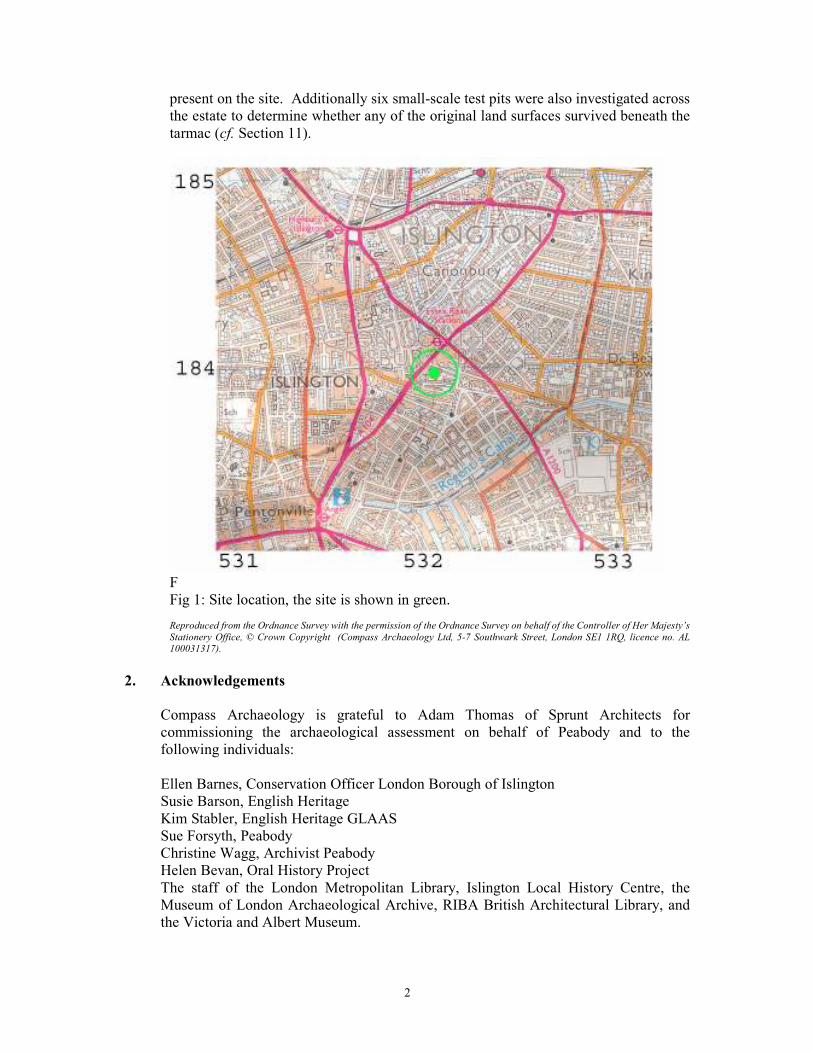
F
Fig 1: Site location, the site is shown in green.
Reproduced from the Ordnance Survey with the permission of the Ordnance Survey on behalf of the Controller of Her Majesty’s
Stationery Office, © Crown Copyright (Compass Archaeology Ltd, 5-7 Southwark Street, London SE1 1RQ, licence no. AL
100031317).
2. Acknowledgements
Compass Archaeology is grateful to Adam Thomas of Sprunt Architects for
commissioning the archaeological assessment on behalf of Peabody and to the
following individuals:
Ellen Barnes, Conservation Officer London Borough of Islington
Susie Barson, English Heritage
Kim Stabler, English Heritage GLAAS
Sue Forsyth, Peabody
Christine Wagg, Archivist Peabody
Helen Bevan, Oral History Project
The staff of the London Metropolitan Library, Islington Local History Centre, the
Museum of London Archaeological Archive, RIBA British Architectural Library, and
the Victoria and Albert Museum.
3
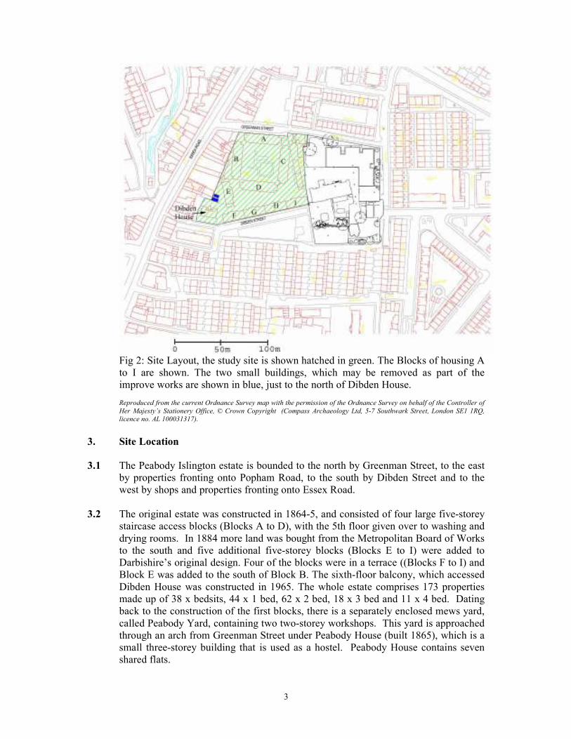
Fig 2: Site Layout, the study site is shown hatched in green. The Blocks of housing A
to I are shown. The two small buildings, which may be removed as part of the
improve works are shown in blue, just to the north of Dibden House. Reproduced from the current Ordnance Survey map with the permission of the Ordnance Survey on behalf of the Controller of
Her Majesty’s Stationery Office, © Crown Copyright (Compass Archaeology Ltd, 5-7 Southwark Street, London SE1 1RQ,
licence no. AL 100031317).
3. Site Location
3.1 The Peabody Islington estate is bounded to the north by Greenman Street, to the east
by properties fronting onto Popham Road, to the south by Dibden Street and to the
west by shops and properties fronting onto Essex Road.
3.2 The original estate was constructed in 1864-5, and consisted of four large five-storey
staircase access blocks (Blocks A to D), with the 5th floor given over to washing and
drying rooms. In 1884 more land was bought from the Metropolitan Board of Works
to the south and five additional five-storey blocks (Blocks E to I) were added to
Darbishire’s original design. Four of the blocks were in a terrace ((Blocks F to I) and
Block E was added to the south of Block B. The sixth-floor balcony, which accessed
Dibden House was constructed in 1965. The whole estate comprises 173 properties
made up of 38 x bedsits, 44 x 1 bed, 62 x 2 bed, 18 x 3 bed and 11 x 4 bed. Dating
back to the construction of the first blocks, there is a separately enclosed mews yard,
called Peabody Yard, containing two two-storey workshops. This yard is approached
through an arch from Greenman Street under Peabody House (built 1865), which is a
small three-storey building that is used as a hostel. Peabody House contains seven
shared flats.
4
3.3 The site lies on gently sloping land, which slopes down to the east from the higher
ground on Essex Road. The site ground surface level is approximately level in the
Square at circa 27m AOD, but the surrounding streets are slightly lower. At the north-
western entrance to the site on Greenman Street the pavement level is 26.9m AOD
and continues at this height within the site gently rising up by about 100mm to the
height of the Square between Blocks A and B. At the north-eastern entrance to the site
on Greenman Street outside Peabody Yard the pavement level is circa 25.3m AOD.
The landscape steps up here to rise nearly two metres to the height of the Square
between Blocks A and C. This reflects the fact that the Square has been built-up on a
plateau, such that the Square is level whereas the area surrounding the Square slopes
down to the east. This is in contrast to the area between Block D and Blocks F-I,
which follows the natural topography more, with the western end of this area at 27m
AOD (the same as within the Square itself), falling to 24.5m at the eastern end (such
that stairs up into Peabody Square are necessary between blocks C and D).
4. Objectives of the IMPROVE programme and this assessment report
4.1 The aim of Peabody’s IMPROVE programme is to implement changes to the outdoor
spaces of their estates which will enhance their residents’ experience, boosting
community, health and wellbeing, biodiversity, social life, and play, whilst being
affordable, durable and environmentally responsible. Peabody wishes to make
improvements to the outdoor spaces at Islington and to further promote community
capacity building and pride within the estate. Most outside areas, even though they are
well-maintained, suffer from age, under-investment and lack of identity, which in turn
affects the use and perception of the estate as a whole. The project aims to actively
work with local residents in the designs through active consultation, in particular
closely linking the development of green spaces with local residents. There is a desire
to increase the percentage of soft landscaping across the site, through innovative
design that both reflects the architectural context and is relevant to the residents’
needs of the present day.
4.2 The historic importance of the estate and its protection through its Grade II listed
status has ensured that the preservation and enhancement of heritage features is an
important part of any proposals for the site. Important heritage landscape features still
survive on the site, including the original signage and hardstandings into Peabody
Yard, the historic kerb in the main-square, and later plinth walls, gullies, gate posts
and other features elsewhere across the site. This year is the 150th anniversary
Peabody’s inception and adds further historical significance to the site. Although the
Grade II designation is applied to the original housing blocks, the protection covers
the entire estate, including landscape, boundaries and pramsheds, etc.
4.3 The objective of this assessment is to establish the nature of the original landscaping
across the site. There are two main elements to the assessment: firstly, detailed
research of all the source material to determine the nature of the original landscaping,
and secondly a detailed walk-round survey of the site plus the investigation of six
small test pits to determine if further evidence remains under the tar and concrete
hardstandings (cf. Section 11).
5
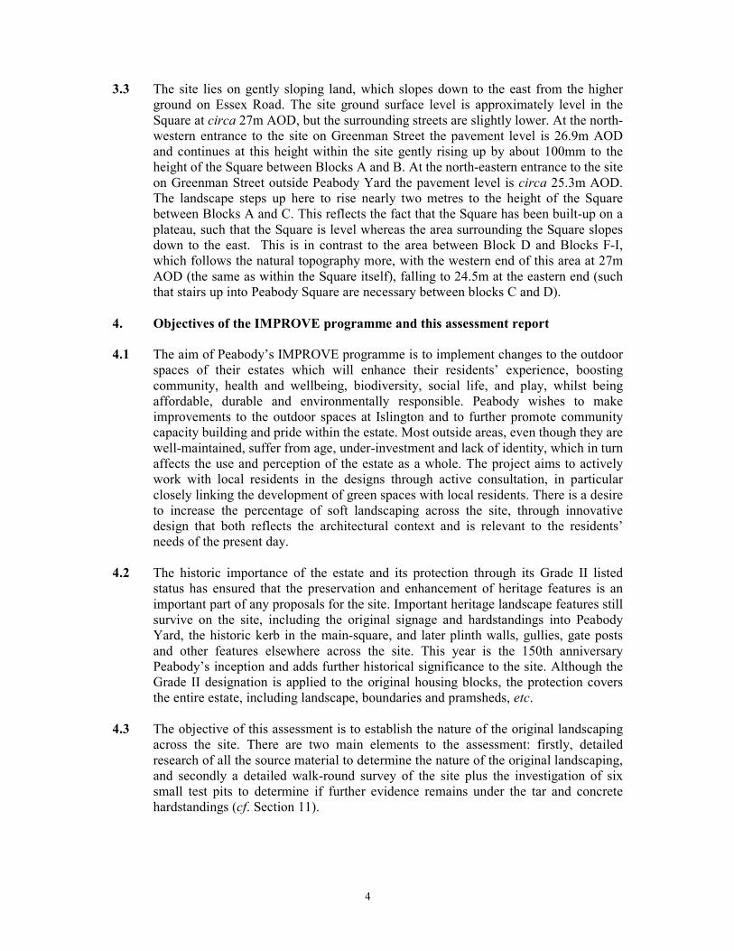
4.4 The Planning Proposal
Fig 3: The site with some sketched indications of a possible proposal. © Sprunt
Architects 2012.
At the time of preparation of this report the final development proposal had yet to be
confirmed. It is proposed to retain some parking within the Square and an area of
playground. The tree in the centre of the site ideally will be removed to re-establish
the symmetry of the Square.
5. Archaeological assessments and planning
5.1 An archaeological assessment represents one element in the archaeological planning
process whereby early consideration of potential archaeological remains or heritage
features can be achieved, and if necessary appropriate mitigation measures put in
place.
5.2 The assessment has been carried out in accordance with current planning legislation
and guidance and follows the recommendations of the Institute for Archaeologists
(IfA 1996). The advice of Ellen Barnes, Conservation Officer for the London Borough
of Islington, was also sought prior to commencement of this assessment and her very
helpful suggestions have formed the framework of this document. Kim Stabler,
English Heritage Archaeological Advisor (GLAAS) to the London Borough of
Islington was also consulted prior to works commencing and similarly offered helpful
guidance. The site was inspected and a number of libraries and archives consulted;
including the Peabody Archive at the London Metropolitan Archive, local news and
photographic records at Islington Local History Centre, and data on Henry Astley
Darbishire held at RIBA British Architectural Library at 66 Portland Place and the
RIBA Architecture Study Rooms, Victoria and Albert Museum. Christine Wagg,
6
archivist for Peabody and Susie Barson, author of the 2001 Conservation guidelines
were also consulted.
5.3 In summary the assessment has involved identifying the sources available for
consultation, obtaining information from them, and thereafter collecting and
examining these sources. Through this process it has been possible to produce an
overview of the archaeological potential of the site, of the extent to which this may
have been reduced by later activity/ previous development, and finally an assessment
of the surviving potential of archaeological remains relating to the original 1864-5
layout. This assessment has been written prior to the submission of a planning
application.
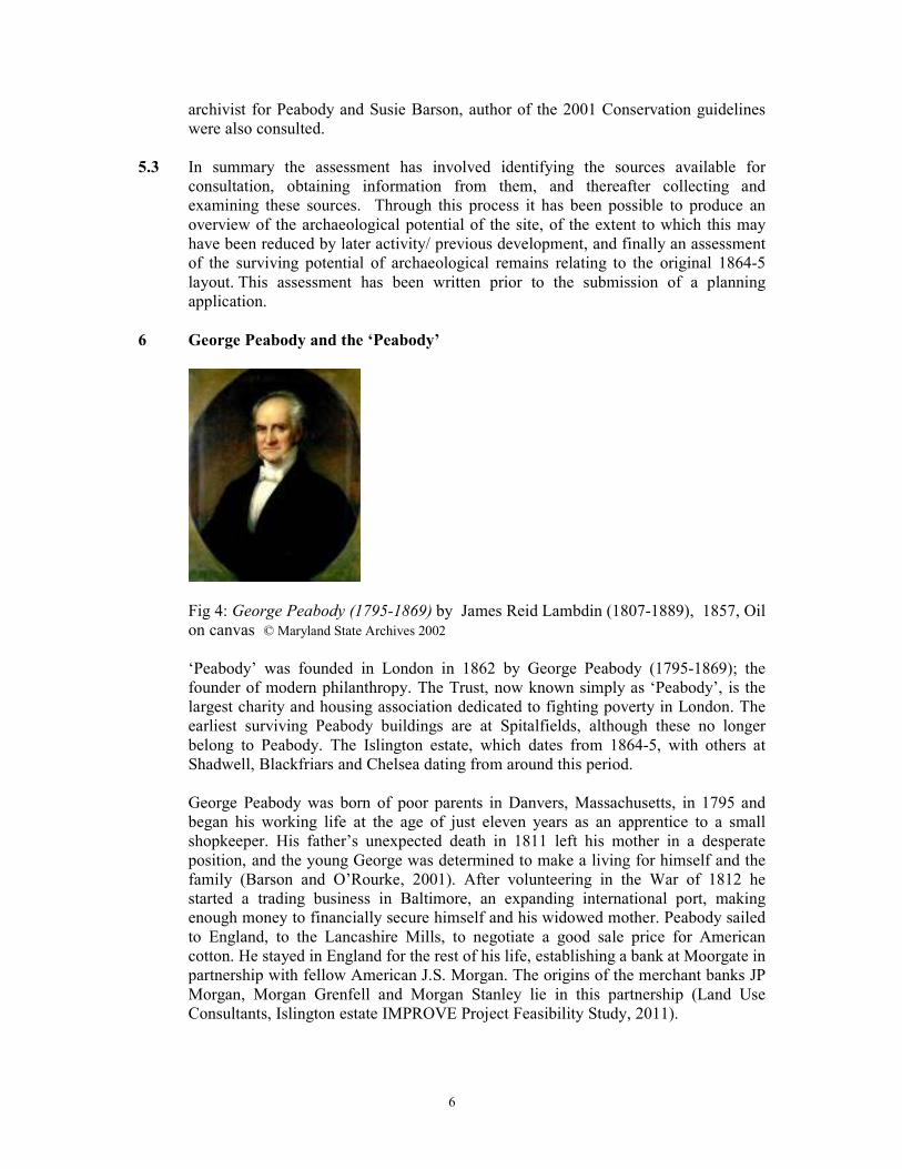
6 George Peabody and the ‘Peabody’
Fig 4: George Peabody (1795-1869) by James Reid Lambdin (1807-1889), 1857, Oil
on canvas © Maryland State Archives 2002
‘Peabody’ was founded in London in 1862 by George Peabody (1795-1869); the
founder of modern philanthropy. The Trust, now known simply as ‘Peabody’, is the
largest charity and housing association dedicated to fighting poverty in London. The
earliest surviving Peabody buildings are at Spitalfields, although these no longer
belong to Peabody. The Islington estate, which dates from 1864-5, with others at
Shadwell, Blackfriars and Chelsea dating from around this period.
George Peabody was born of poor parents in Danvers, Massachusetts, in 1795 and
began his working life at the age of just eleven years as an apprentice to a small
shopkeeper. His father’s unexpected death in 1811 left his mother in a desperate
position, and the young George was determined to make a living for himself and the
family (Barson and O’Rourke, 2001). After volunteering in the War of 1812 he
started a trading business in Baltimore, an expanding international port, making
enough money to financially secure himself and his widowed mother. Peabody sailed
to England, to the Lancashire Mills, to negotiate a good sale price for American
cotton. He stayed in England for the rest of his life, establishing a bank at Moorgate in
partnership with fellow American J.S. Morgan. The origins of the merchant banks JP
Morgan, Morgan Grenfell and Morgan Stanley lie in this partnership (Land Use
Consultants, Islington estate IMPROVE Project Feasibility Study, 2011).
7
Peabody found himself in a circle of reformers and philanthropists (including Lady
Burdett-Coutts and Lord Shaftesbury). Like his friends, Peabody was concerned by
the pitiful and dangerous living conditions of poor Londoners. In 1862 he established
the ‘Peabody Trust’ with a sum of £150,000, his gift to London. The Trust declared
their intention to use the money on the provision of housing, and thus began the
remarkable programme of social housing, which made the name of Peabody famous
in London (Barson and O’Rourke, 2001, p. 10).
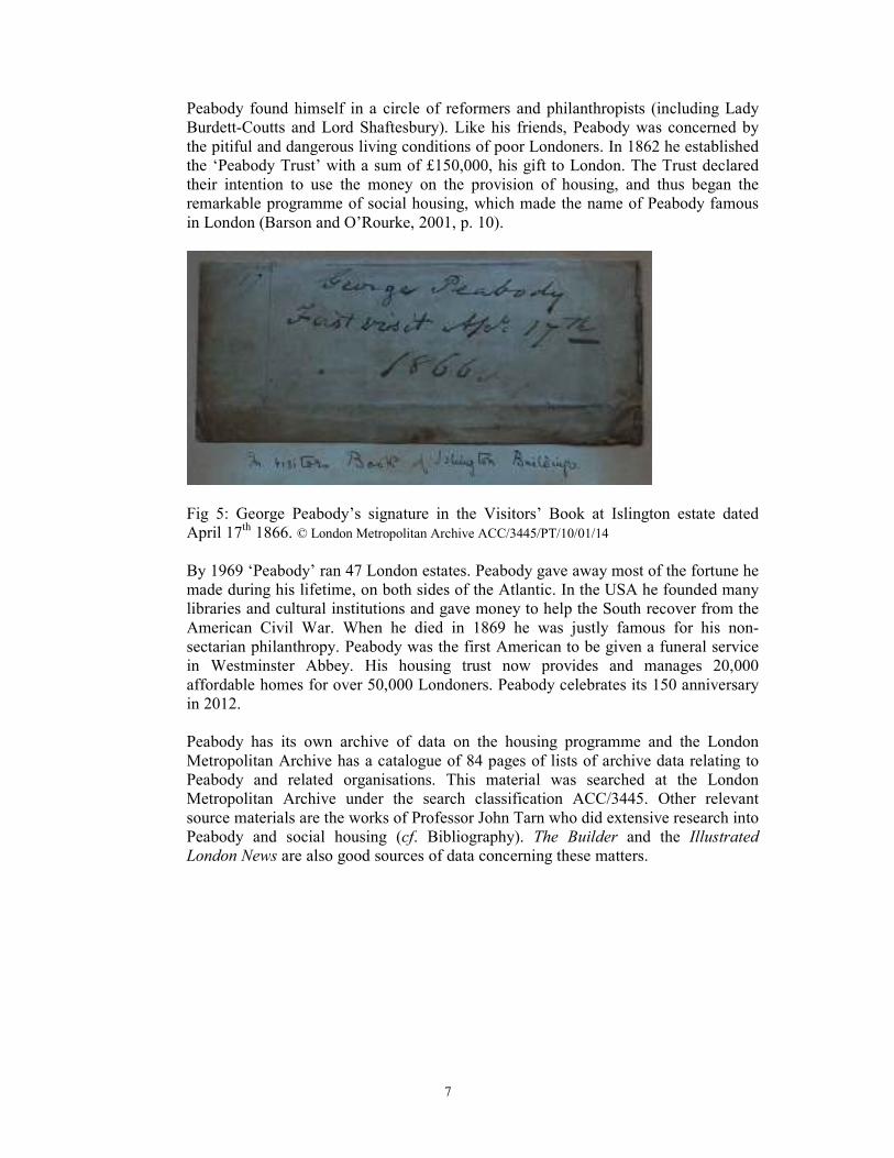
Fig 5: George Peabody’s signature in the Visitors’ Book at Islington estate dated
April 17th 1866. © London Metropolitan Archive ACC/3445/PT/10/01/14
By 1969 ‘Peabody’ ran 47 London estates. Peabody gave away most of the fortune he
made during his lifetime, on both sides of the Atlantic. In the USA he founded many
libraries and cultural institutions and gave money to help the South recover from the
American Civil War. When he died in 1869 he was justly famous for his non-
sectarian philanthropy. Peabody was the first American to be given a funeral service
in Westminster Abbey. His housing trust now provides and manages 20,000
affordable homes for over 50,000 Londoners. Peabody celebrates its 150 anniversary
in 2012.
Peabody has its own archive of data on the housing programme and the London
Metropolitan Archive has a catalogue of 84 pages of lists of archive data relating to
Peabody and related organisations. This material was searched at the London
Metropolitan Archive under the search classification ACC/3445. Other relevant
source materials are the works of Professor John Tarn who did extensive research into
Peabody and social housing (cf. Bibliography). The Builder and the Illustrated
London News are also good sources of data concerning these matters.
8
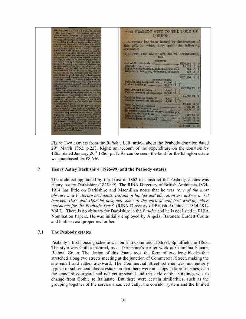
Fig 6: Two extracts from the Builder. Left: article about the Peabody donation dated
29th March 1862, p.228. Right: an account of the expenditure on the donation by
1865, dated January 20th 1866, p.51. As can be seen, the land for the Islington estate
was purchased for £8,646.
7 Henry Astley Darbishire (1825-99) and the Peabody estates
The architect appointed by the Trust in 1862 to construct the Peabody estates was
Henry Astley Darbishire (1825-99). The RIBA Directory of British Architects 1834-
1914 has little on Darbishire and Macmillan notes that he was ‘one of the most
obscure mid-Victorian architects. Details of his life and education are unknown. Yet
between 1857 and 1868 he designed some of the earliest and best working class
tenements for the Peabody Trust’ (RIBA Directory of British Architects 1834-1914
Vol I). There is no obituary for Darbishire in the Builder and he is not listed in RIBA
Nomination Papers. He was initially employed by Angela, Baroness Burdett Coutts
and built several properties for her.
7.1 The Peabody estates
Peabody’s first housing scheme was built in Commercial Street, Spitalfields in 1863.
The style was Gothic-inspired, as at Darbishire’s earlier work at Columbia Square,
Bethnal Green. The design of this Estate took the form of two long blocks that
stretched along two streets meeting at the junction of Commercial Street, making the
site small and rather awkward. The Commercial Street scheme was not entirely
typical of subsequent classic estates in that there were no shops in later schemes; also
the standard courtyard had not yet appeared and the style of the buildings was to
change from Gothic to Italianate. But there were certain similarities, such as the
grouping together of the service areas vertically, the corridor system and the limited
9
number of staircases, as well as the association with Cubitts, the contracting firm
responsible for most of the subsequent estates.
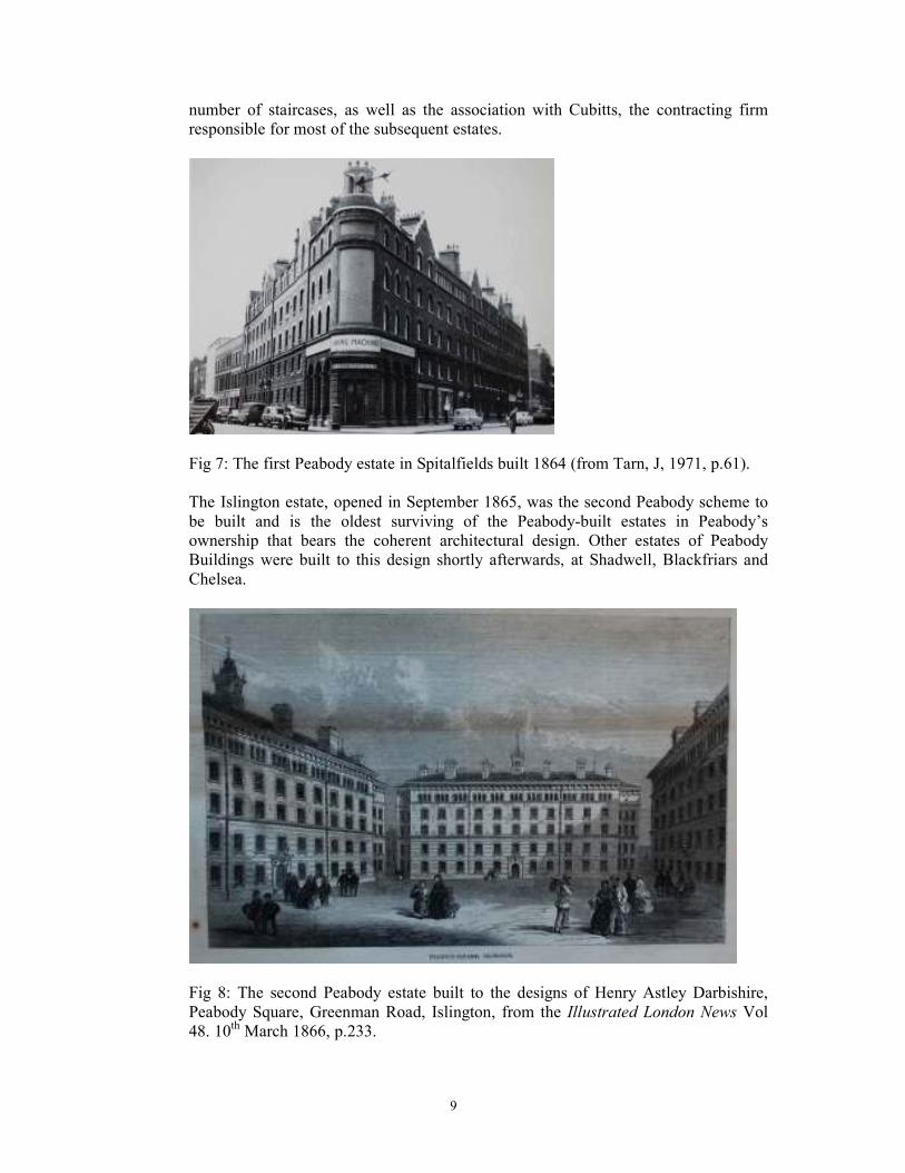
Fig 7: The first Peabody estate in Spitalfields built 1864 (from Tarn, J, 1971, p.61).
The Islington estate, opened in September 1865, was the second Peabody scheme to
be built and is the oldest surviving of the Peabody-built estates in Peabody’s
ownership that bears the coherent architectural design. Other estates of Peabody
Buildings were built to this design shortly afterwards, at Shadwell, Blackfriars and
Chelsea.
Fig 8: The second Peabody estate built to the designs of Henry Astley Darbishire,
Peabody Square, Greenman Road, Islington, from the Illustrated London News Vol
48. 10th March 1866, p.233.
10
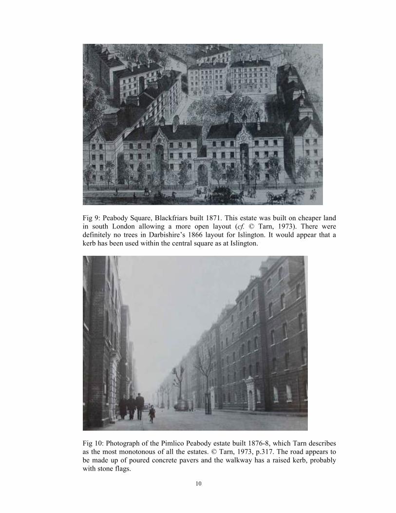
Fig 9: Peabody Square, Blackfriars built 1871. This estate was built on cheaper land
in south London allowing a more open layout (cf. © Tarn, 1973). There were
definitely no trees in Darbishire’s 1866 layout for Islington. It would appear that a
kerb has been used within the central square as at Islington.
Fig 10: Photograph of the Pimlico Peabody estate built 1876-8, which Tarn describes
as the most monotonous of all the estates. © Tarn, 1973, p.317. The road appears to
be made up of poured concrete pavers and the walkway has a raised kerb, probably
with stone flags.
11
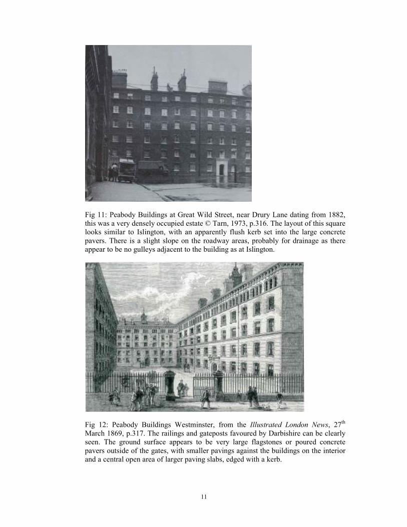
Fig 11: Peabody Buildings at Great Wild Street, near Drury Lane dating from 1882,
this was a very densely occupied estate © Tarn, 1973, p.316. The layout of this square
looks similar to Islington, with an apparently flush kerb set into the large concrete
pavers. There is a slight slope on the roadway areas, probably for drainage as there
appear to be no gulleys adjacent to the building as at Islington.
Fig 12: Peabody Buildings Westminster, from the Illustrated London News, 27th
March 1869, p.317. The railings and gateposts favoured by Darbishire can be clearly
seen. The ground surface appears to be very large flagstones or poured concrete
pavers outside of the gates, with smaller pavings against the buildings on the interior
and a central open area of larger paving slabs, edged with a kerb.
12
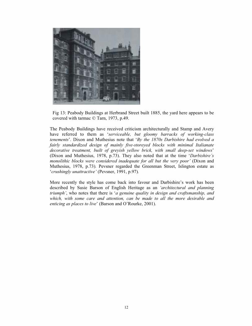
Fig 13: Peabody Buildings at Herbrand Street built 1885, the yard here appears to be
covered with tarmac © Tarn, 1973, p.49.
The Peabody Buildings have received criticism architecturally and Stamp and Avery
have referred to them as ‘serviceable, but gloomy barracks of working-class
tenements’. Dixon and Muthesius note that ‘By the 1870s Darbishire had evolved a
fairly standardized design of mainly five-storeyed blocks with minimal Italianate
decorative treatment, built of greyish yellow brick, with small deep-set windows’
(Dixon and Muthesius, 1978, p.73). They also noted that at the time ‘Darbishire’s
monolithic blocks were considered inadequate for all but the very poor’ (Dixon and
Muthesius, 1978, p.73). Pevsner regarded the Greenman Street, Islington estate as
‘crushingly unattractive’ (Pevsner, 1991, p.97).
More recently the style has come back into favour and Darbishire’s work has been
described by Susie Barson of English Heritage as an ‘architectural and planning
triumph’, who notes that there is ‘a genuine quality in design and craftsmanship, and
which, with some care and attention, can be made to all the more desirable and
enticing as places to live’ (Barson and O’Rourke, 2001).
13
8 Archaeological and Historical background to the Islington site
An on-line search of the Historic Environment record revealed very few entries for
archaeological finds or features within a 250m radius of the site. A single residual
sherd of Saxon pottery was recorded within waterlain deposits at 71-85 Essex Road
(SMR ref: 082938). An early 17th century culvert may have been part of the New
River Tunnel. There are also several entries for small-scale and broadly negative
archaeological investigations.
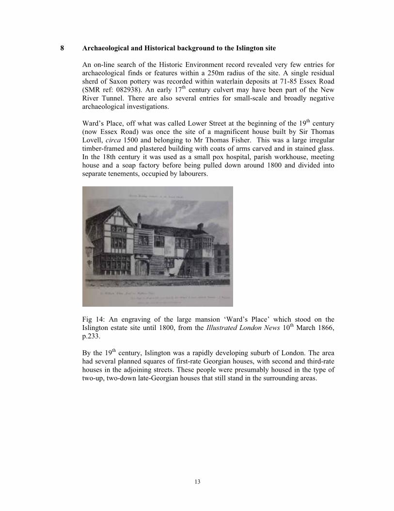
Ward’s Place, off what was called Lower Street at the beginning of the 19th century
(now Essex Road) was once the site of a magnificent house built by Sir Thomas
Lovell, circa 1500 and belonging to Mr Thomas Fisher. This was a large irregular
timber-framed and plastered building with coats of arms carved and in stained glass.
In the 18th century it was used as a small pox hospital, parish workhouse, meeting
house and a soap factory before being pulled down around 1800 and divided into
separate tenements, occupied by labourers.
Fig 14: An engraving of the large mansion ‘Ward’s Place’ which stood on the
Islington estate site until 1800, from the Illustrated London News 10th March 1866,
p.233.
By the 19th century, Islington was a rapidly developing suburb of London. The area
had several planned squares of first-rate Georgian houses, with second and third-rate
houses in the adjoining streets. These people were presumably housed in the type of
two-up, two-down late-Georgian houses that still stand in the surrounding areas.
14
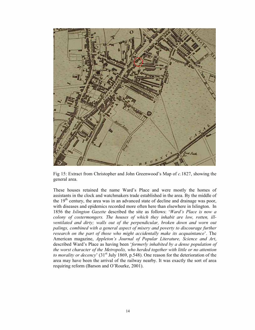
Fig 15: Extract from Christopher and John Greenwood’s Map of c.1827, showing the
general area.
These houses retained the name Ward’s Place and were mostly the homes of
assistants in the clock and watchmakers trade established in the area. By the middle of
the 19th century, the area was in an advanced state of decline and drainage was poor,
with diseases and epidemics recorded more often here than elsewhere in Islington. In
1856 the Islington Gazette described the site as follows: ‘Ward’s Place is now a
colony of costermongers. The houses of which they inhabit are low, rotten, ill-
ventilated and dirty; walls out of the perpendicular, broken down and worn out
palings, combined with a general aspect of misery and poverty to discourage further
research on the part of those who might accidentally make its acquaintance’. The
American magazine, Appleton’s Journal of Popular Literature, Science and Art,
described Ward’s Place as having been ‘formerly inhabited by a dense population of
the worst character of the Metropolis, who herded together with little or no attention
to morality or decency’ (31st July 1869, p.548). One reason for the deterioration of the
area may have been the arrival of the railway nearby. It was exactly the sort of area
requiring reform (Barson and O’Rourke, 2001).
15
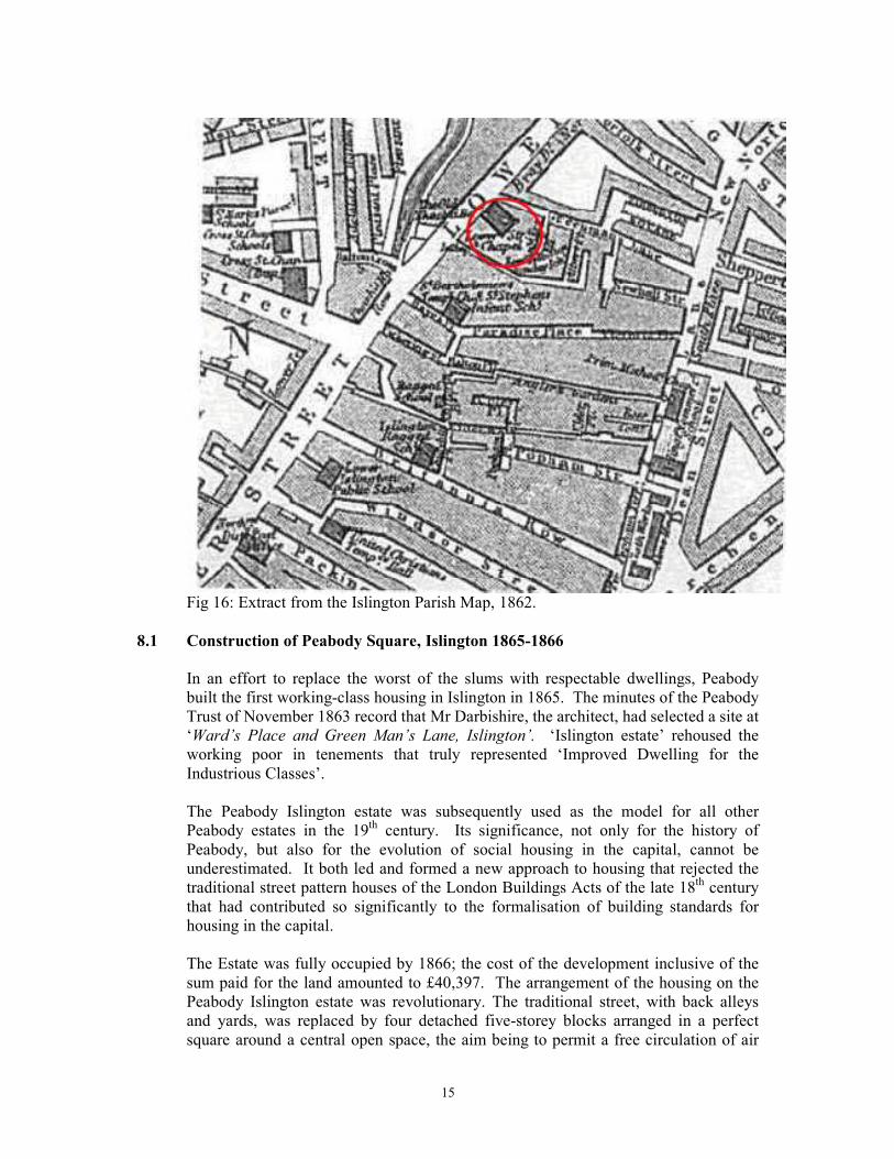
Fig 16: Extract from the Islington Parish Map, 1862.
8.1 Construction of Peabody Square, Islington 1865-1866
In an effort to replace the worst of the slums with respectable dwellings, Peabody
built the first working-class housing in Islington in 1865. The minutes of the Peabody
Trust of November 1863 record that Mr Darbishire, the architect, had selected a site at
‘Ward’s Place and Green Man’s Lane, Islington’. ‘Islington estate’ rehoused the
working poor in tenements that truly represented ‘Improved Dwelling for the
Industrious Classes’.
The Peabody Islington estate was subsequently used as the model for all other
Peabody estates in the 19th century. Its significance, not only for the history of
Peabody, but also for the evolution of social housing in the capital, cannot be
underestimated. It both led and formed a new approach to housing that rejected the
traditional street pattern houses of the London Buildings Acts of the late 18th century
that had contributed so significantly to the formalisation of building standards for
housing in the capital.
The Estate was fully occupied by 1866; the cost of the development inclusive of the
sum paid for the land amounted to £40,397. The arrangement of the housing on the
Peabody Islington estate was revolutionary. The traditional street, with back alleys
and yards, was replaced by four detached five-storey blocks arranged in a perfect
square around a central open space, the aim being to permit a free circulation of air
16
and to serve as playgrounds for the children of the tenants. Iron gates closed the
entrance at 11.00pm cutting out all undesirable neighbours.
To the east of the original four blocks was Peabody Yard which contained two ranges
of workshops, twelve in total, which were built for rent at six shillings and sixpence
per week. Controlling access to the site was the Superintendent’s House - Peabody
House. Provision for coal stores and, later, pram sheds were also made on the site.
Some of these still survive.
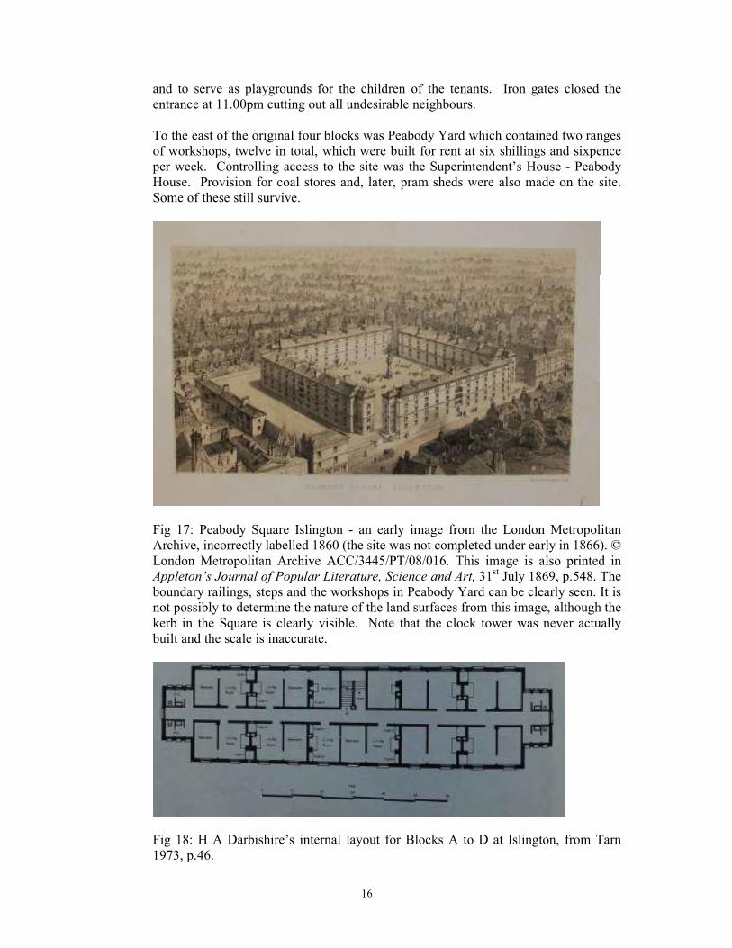
Fig 17: Peabody Square Islington - an early image from the London Metropolitan
Archive, incorrectly labelled 1860 (the site was not completed under early in 1866). ©
London Metropolitan Archive ACC/3445/PT/08/016. This image is also printed in
Appleton’s Journal of Popular Literature, Science and Art, 31st July 1869, p.548. The
boundary railings, steps and the workshops in Peabody Yard can be clearly seen. It is
not possibly to determine the nature of the land surfaces from this image, although the
kerb in the Square is clearly visible. Note that the clock tower was never actually
built and the scale is inaccurate.
Fig 18: H A Darbishire’s internal layout for Blocks A to D at Islington, from Tarn
1973, p.46.
17
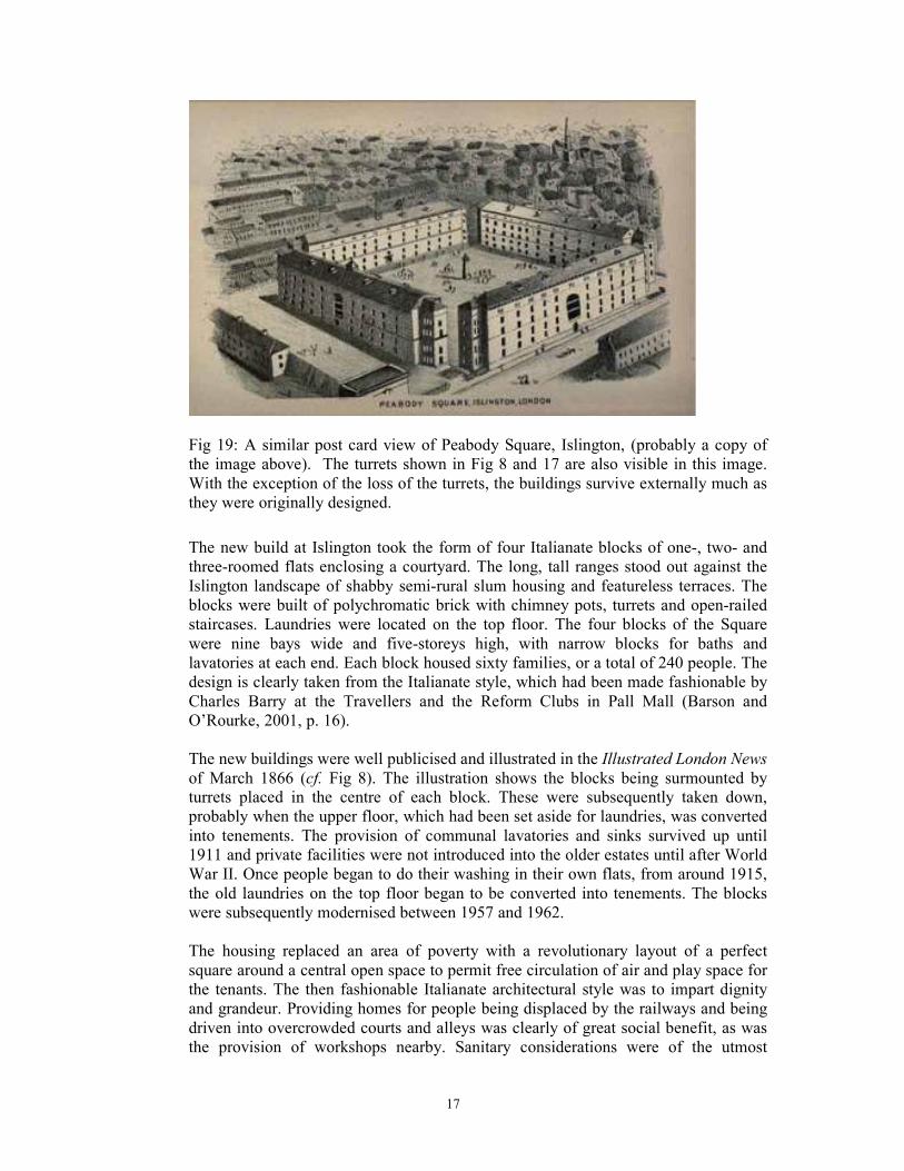
Fig 19: A similar post card view of Peabody Square, Islington, (probably a copy of
the image above). The turrets shown in Fig 8 and 17 are also visible in this image.
With the exception of the loss of the turrets, the buildings survive externally much as
they were originally designed.
The new build at Islington took the form of four Italianate blocks of one-, two- and
three-roomed flats enclosing a courtyard. The long, tall ranges stood out against the
Islington landscape of shabby semi-rural slum housing and featureless terraces. The
blocks were built of polychromatic brick with chimney pots, turrets and open-railed
staircases. Laundries were located on the top floor. The four blocks of the Square
were nine bays wide and five-storeys high, with narrow blocks for baths and
lavatories at each end. Each block housed sixty families, or a total of 240 people. The
design is clearly taken from the Italianate style, which had been made fashionable by
Charles Barry at the Travellers and the Reform Clubs in Pall Mall (Barson and
O’Rourke, 2001, p. 16).
The new buildings were well publicised and illustrated in the Illustrated London News
of March 1866 (cf. Fig 8). The illustration shows the blocks being surmounted by
turrets placed in the centre of each block. These were subsequently taken down,
probably when the upper floor, which had been set aside for laundries, was converted
into tenements. The provision of communal lavatories and sinks survived up until
1911 and private facilities were not introduced into the older estates until after World
War II. Once people began to do their washing in their own flats, from around 1915,
the old laundries on the top floor began to be converted into tenements. The blocks
were subsequently modernised between 1957 and 1962.
The housing replaced an area of poverty with a revolutionary layout of a perfect
square around a central open space to permit free circulation of air and play space for
the tenants. The then fashionable Italianate architectural style was to impart dignity
and grandeur. Providing homes for people being displaced by the railways and being
driven into overcrowded courts and alleys was clearly of great social benefit, as was
the provision of workshops nearby. Sanitary considerations were of the utmost
18
importance, and in 1891 Newsholme’s report claimed that the residents of Peabody
housing were actually healthier than the rest of London’s population.
The Islington estate had gates that separated its inhabitants from the perceived evils of
the outside world. The surrounding walls, railings and gates were the means of
achieving this and supervising it all was Peabody House, situated just down
Greenman Street over Peabody Yard; the Superintendent being resident in one of the
flats. The courtyard with gates was felt to be successful in protecting the tenants from
‘evil social intercourse’, which were closed at 11pm. The character of such railings
and gates is discussed by Darbishire in his 1875 article: ‘These, like the site and
drainage, are subject to great variation. Adjacent properties may supply a good fence
in some cases; the shape of the site may enable the dwellings themselves to form a
portion of the boundary in others. One class of neighbourhood will make high walls
necessary; in another, an open railing or wood fence will be sufficient. No uniform
rule can be laid down as to what will be suitable, economical or desirable in every
case, and as the material of the fences varies, so also will their cost.’ (Darbishire,
1875, p.45-68).
Another key feature of the Peabody estates was the central Square, around which the
housing blocks were arranged. Darbishire describes the need for these and their ideal
layout in his 1875 article: ‘If the health and recreation of the tenants are to be
considered, and the dwellings are to have play grounds in addition to their other
attractions, these spaces require careful attention. They must be made cheerful, but
not ornamental, with plants or shrubs, which need constant care, and they must be
covered with some durable surface, which shall neither look prison-like nor enable
children to destroy it without difficulty. In limited spaces stone, tile or brick
pavements will answer well, but in large spaces these become too expensive, and as
gravel has many objections, the covering which is found to answer best is the
concrete already described [see below]’ (Darbishire, 1875, p.45-68).
There has been a large amount of debate concerning the type of surfacing used within
the Squares. The ‘concrete already described’ Darbishire mentions in 1875 is ‘a fine
concrete laid over a bed of rougher concrete 9 inches thick, and finished with a
surface of Portland cement, the whole being 11 inches in thickness’. He also favoured
‘Hobman’s tar-paving, laid upon a bed of rough concrete, and finished with a fine
surface resembling asphalte’ (Darbishire, 1875, p.45-68). A.C.W. Hobman & Co. was
established circa 1890 and their tar paving was used widely by the School Board for
London and found to be cheaper and better than most other tar surfaces. In 1875
Darbishire particularly mentions his dislike of the use of gravel, stating that it is
‘dusty and dry in bad weather and occasions stone throwing and broken windows’; it
appears he speaks from experience perhaps a result of using gravel as the surfacing at
Islington in the 1860s (Darbishire, 1875, p.45-68). In later documents, however, the
use of granolithic paving is mentioned.
Granolithic paving is a type of construction material composed of cement and
fine aggregate such as granite or other hard-wearing rock. It is generally used as
flooring, or as paving. It has a similar appearance to concrete, and is used to provide a
durable surface where texture and appearance are usually not important (such as
outdoor pathways or factory floors).
19
A greater discussion of this, combined with the results from the intrusive on-site
investigations, is included below in Section 11.
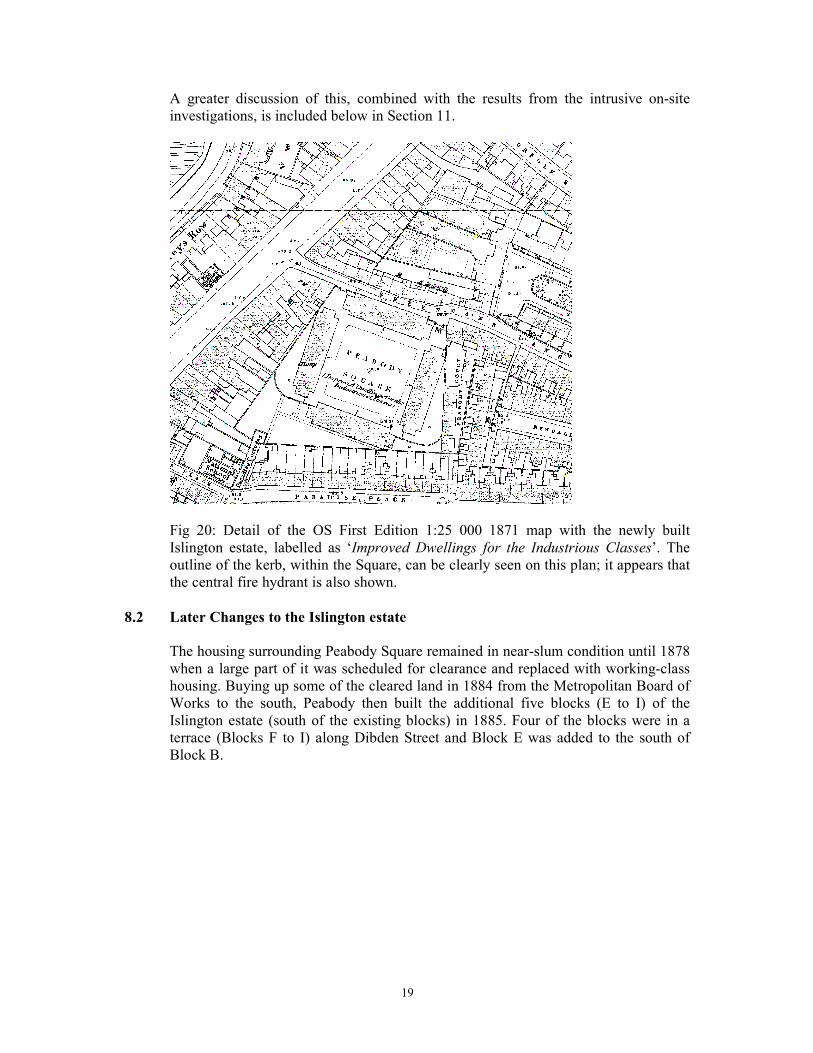
Fig 20: Detail of the OS First Edition 1:25 000 1871 map with the newly built
Islington estate, labelled as ‘Improved Dwellings for the Industrious Classes’. The
outline of the kerb, within the Square, can be clearly seen on this plan; it appears that
the central fire hydrant is also shown.
8.2 Later Changes to the Islington estate
The housing surrounding Peabody Square remained in near-slum condition until 1878
when a large part of it was scheduled for clearance and replaced with working-class
housing. Buying up some of the cleared land in 1884 from the Metropolitan Board of
Works to the south, Peabody then built the additional five blocks (E to I) of the
Islington estate (south of the existing blocks) in 1885. Four of the blocks were in a
terrace (Blocks F to I) along Dibden Street and Block E was added to the south of
Block B.
20
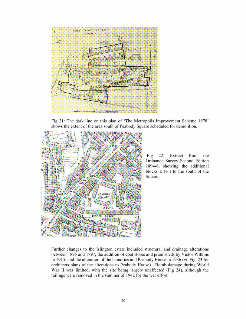
Fig 21: The dark line on this plan of ‘The Metropolis Improvement Scheme 1878’
shows the extent of the area south of Peabody Square scheduled for demolition.
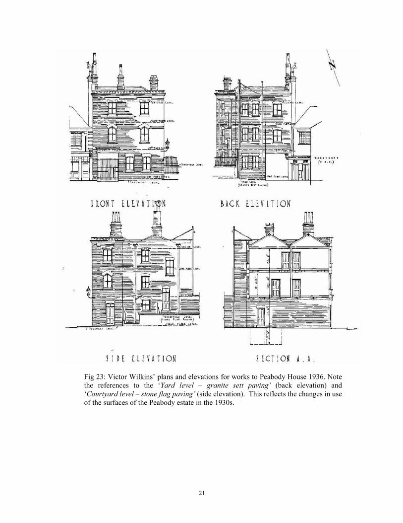
Fig 22: Extract from the
Ordnance Survey Second Edition
1894-6, showing the additional
blocks E to I to the south of the
Square.
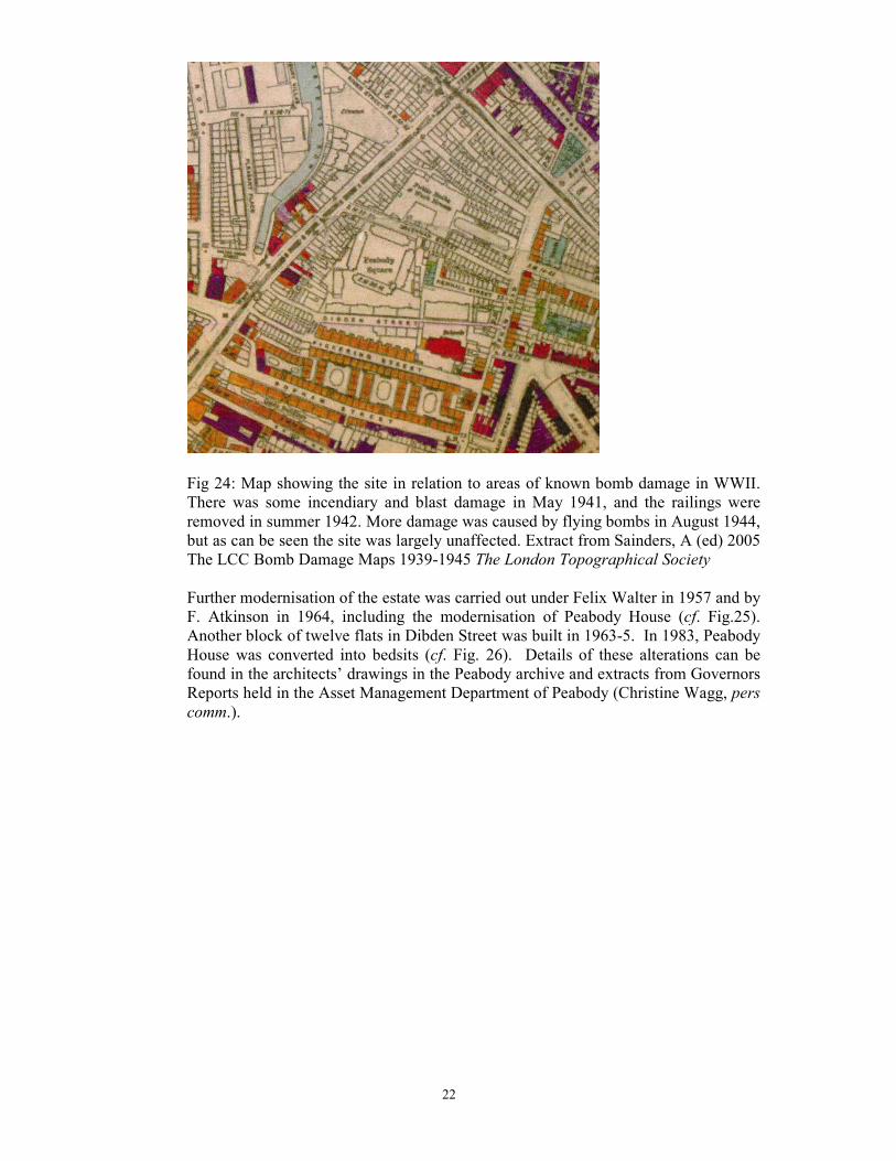
Further changes to the Islington estate included structural and drainage alterations
between 1895 and 1897, the addition of coal stores and pram sheds by Victor Wilkins
in 1915, and the alteration of the laundries and Peabody House in 1936 (cf. Fig. 23 for
architects plans of the alterations to Peabody House). Bomb damage during World
War II was limited, with the site being largely unaffected (Fig 24), although the
railings were removed in the summer of 1942 for the war effort.
21
Fig 23: Victor Wilkins’ plans and elevations for works to Peabody House 1936. Note
the references to the ‘Yard level – granite sett paving’ (back elevation) and
‘Courtyard level – stone flag paving’ (side elevation). This reflects the changes in use
of the surfaces of the Peabody estate in the 1930s.
22
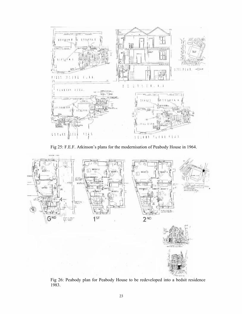
Fig 24: Map showing the site in relation to areas of known bomb damage in WWII.
There was some incendiary and blast damage in May 1941, and the railings were
removed in summer 1942. More damage was caused by flying bombs in August 1944,
but as can be seen the site was largely unaffected. Extract from Sainders, A (ed) 2005
The LCC Bomb Damage Maps 1939-1945 The London Topographical Society
Further modernisation of the estate was carried out under Felix Walter in 1957 and by
F. Atkinson in 1964, including the modernisation of Peabody House (cf. Fig.25).
Another block of twelve flats in Dibden Street was built in 1963-5. In 1983, Peabody
House was converted into bedsits (cf. Fig. 26). Details of these alterations can be
found in the architects’ drawings in the Peabody archive and extracts from Governors
Reports held in the Asset Management Department of Peabody (Christine Wagg, pers
comm.).
23
Fig 25: F.E.F. Atkinson’s plans for the modernisation of Peabody House in 1964.
Fig 26: Peabody plan for Peabody House to be redeveloped into a bedsit residence
1983.
24
8.3 The Estate Today
The whole estate now comprises 173 properties made up of 38 x bedsits, 44 x 1 bed,
62 x 2 bed, 18 x 3 bed and 11 x 4 bed. Peabody Yard contains two two-storey
workshop and Peabody House, which contains seven shared flats.
9 The current site: walkover survey and on-site investigations
The site was visited on 9th March 2012 and 20
th March 2012, and a visual inspection
undertaken and series of photographs taken, to determine what heritage features
survive on the site.
The first section (9) concerns the features from the original construction of the Estate
(1865). The second section (10) details the features from the first major phase of
expansion of the Estate – essentially to the south with the construction of Blocks E – I
and the Dibden Street entrance – in 1885.
Section 11 details the results of six test pits dug across the site.
10 The Original Estate - 1865
The first part of this report details the features from the original construction of the
Estate by Henry Darbishire in 1865. This includes discussion of the entrances from
Greenman Street, Peabody Square, and Peabody Yard. Any surviving heritage
features of this original construction will be discussed, and compared with the
evidence for how it was when it was first constructed using evidence from early maps
and illustrations. The results from the intrusive investigations in this area are also
incorporated.
10.1 Entrances from Greenman Street
10.1.1 The original entrances to Peabody Square were from Greenman Street, one at either
end of Block A. These are clearly depicted on the First Edition 1871 Map (Fig. 20).
The eastern one appears to consist of a gate providing access through the railings,
with steps following this up into the square. The western one, in contrast, just consists
of the gate through the railings, with no associated steps. This is because of the
varying land surface of this area, as the natural land surface slopes away to the east
away from Essex Road, however Peabody Square was constructed on a flat surface
thereby consisting of a large quantity of made-ground material at its eastern end.
Steps into the square from Greenman Street would therefore have been necessary at
this eastern end.
These would have provided the main entrances to the Square. The iron gates would
have been shut at 11pm every night (presumably by the Superintendant whose house
was located in Peabody Yard), as a way of controlling the tenants and preventing ‘evil
social intercourse’ from taking place.
Some indication of the type and appearance of entrance can be seen in historic images
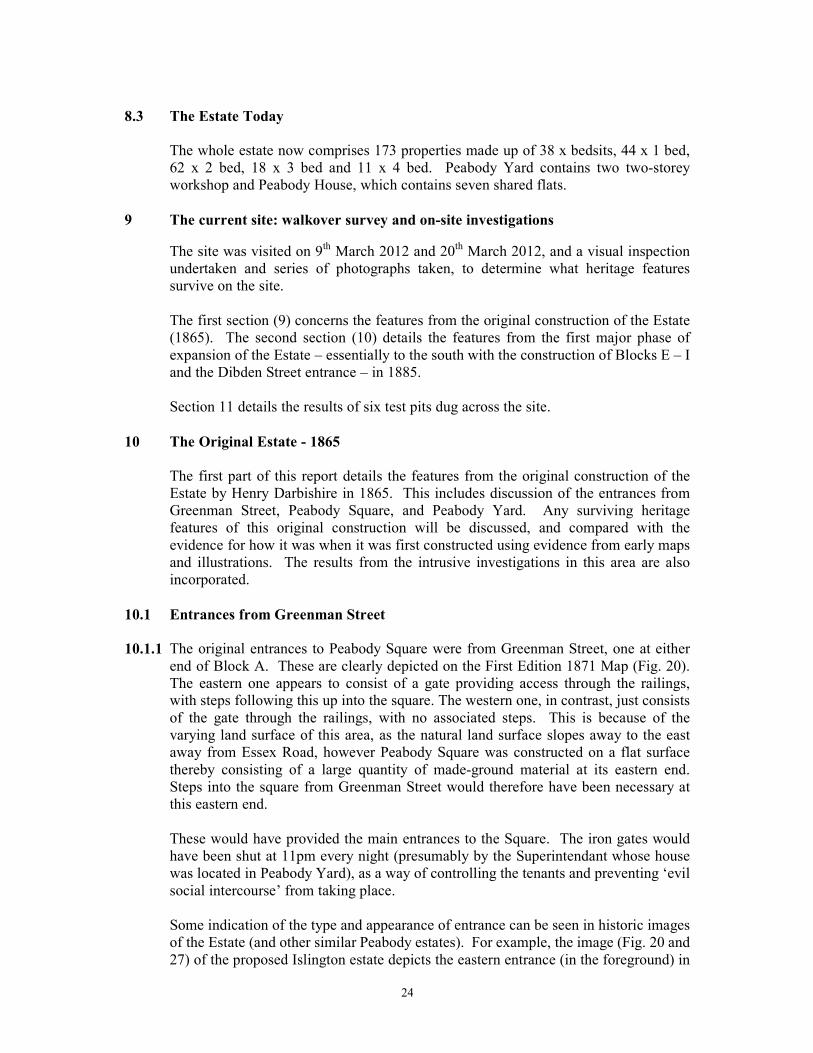
of the Estate (and other similar Peabody estates). For example, the image (Fig. 20 and
27) of the proposed Islington estate depicts the eastern entrance (in the foreground) in
25
the same location as it is on the First Edition OS Map, and with steps leading into the
square, with the western entrance (in the background) lacking these steps. The type of
railings and gate (with gate-posts and capping stones) which may have been found on
the Islington estate can be seen in the below image of the Westminster Peabody estate
(Fig. 27).
Henry Darbishire discusses the type of railings / fences used on the Peabody estates in
his 1875 article ‘On dwellings for the Poor’, where he suggests that their form varied
between different sites: “One class of neighbourhood will make high walls necessary;
in another, an open railing or wood fence will be sufficient. No uniform rule can be
laid down as to what will be suitable, economical or desirable in every case, and as
the material of the fences varies, so also will their cost’ (Darbishire, 1875). The
apparent use of iron railings, on low walls, suggests that the Islington estate was
considered to be located in a relatively safe area.
Fig 27: Peabody Square Islington - an early image from the London Metropolitan
Archive, incorrectly labelled 1860. The two entrances from Greenman Street can
clearly be seen (see also Fig 20).
26
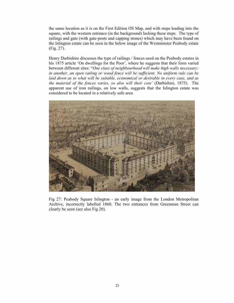
Fig 28: Peabody Buildings Westminster, from the Illustrated London News, 27th
March 1869, p.317. The type of entrance – with railings, gates, and gate-piers, is
clearly illustrated.
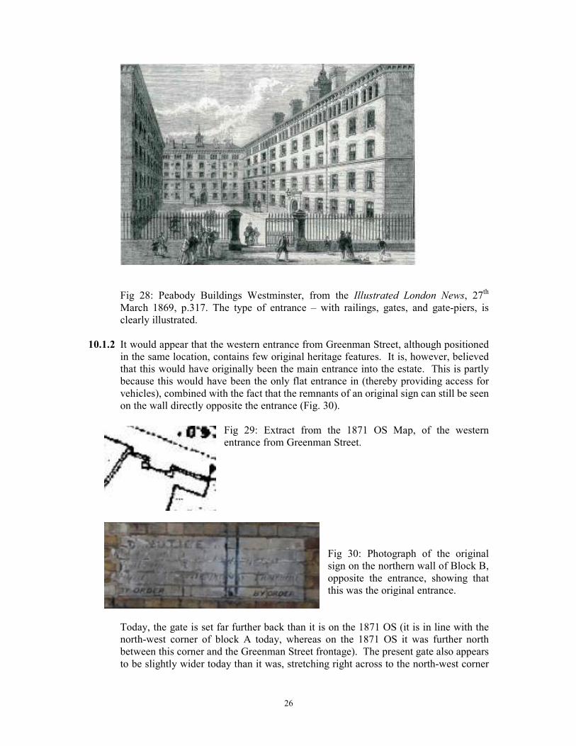
10.1.2 It would appear that the western entrance from Greenman Street, although positioned
in the same location, contains few original heritage features. It is, however, believed
that this would have originally been the main entrance into the estate. This is partly
because this would have been the only flat entrance in (thereby providing access for
vehicles), combined with the fact that the remnants of an original sign can still be seen
on the wall directly opposite the entrance (Fig. 30).
Fig 29: Extract from the 1871 OS Map, of the western
entrance from Greenman Street.
Fig 30: Photograph of the original
sign on the northern wall of Block B,
opposite the entrance, showing that
this was the original entrance.
Today, the gate is set far further back than it is on the 1871 OS (it is in line with the
north-west corner of block A today, whereas on the 1871 OS it was further north
between this corner and the Greenman Street frontage). The present gate also appears
to be slightly wider today than it was, stretching right across to the north-west corner
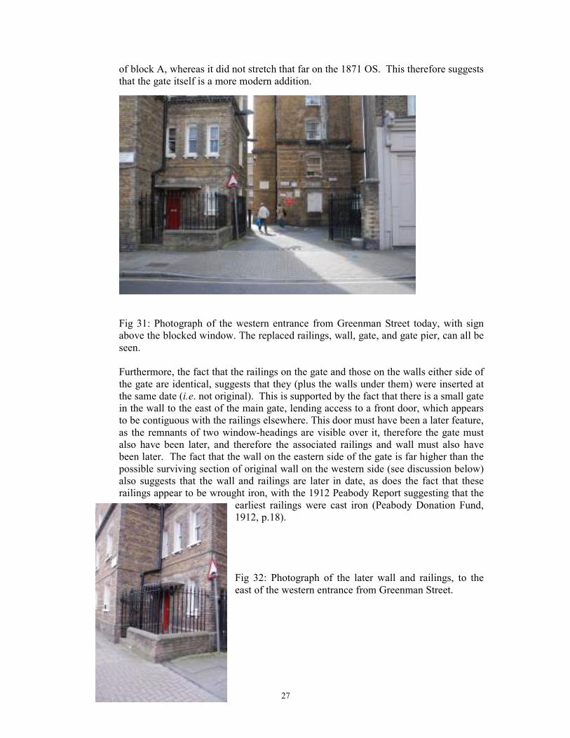
27
of block A, whereas it did not stretch that far on the 1871 OS. This therefore suggests
that the gate itself is a more modern addition.
Fig 31: Photograph of the western entrance from Greenman Street today, with sign
above the blocked window. The replaced railings, wall, gate, and gate pier, can all be
seen.
Furthermore, the fact that the railings on the gate and those on the walls either side of
the gate are identical, suggests that they (plus the walls under them) were inserted at
the same date (i.e. not original). This is supported by the fact that there is a small gate
in the wall to the east of the main gate, lending access to a front door, which appears
to be contiguous with the railings elsewhere. This door must have been a later feature,
as the remnants of two window-headings are visible over it, therefore the gate must
also have been later, and therefore the associated railings and wall must also have
been later. The fact that the wall on the eastern side of the gate is far higher than the
possible surviving section of original wall on the western side (see discussion below)
also suggests that the wall and railings are later in date, as does the fact that these
railings appear to be wrought iron, with the 1912 Peabody Report suggesting that the
earliest railings were cast iron (Peabody Donation Fund,
1912, p.18).
Fig 32: Photograph of the later wall and railings, to the
east of the western entrance from Greenman Street.
28
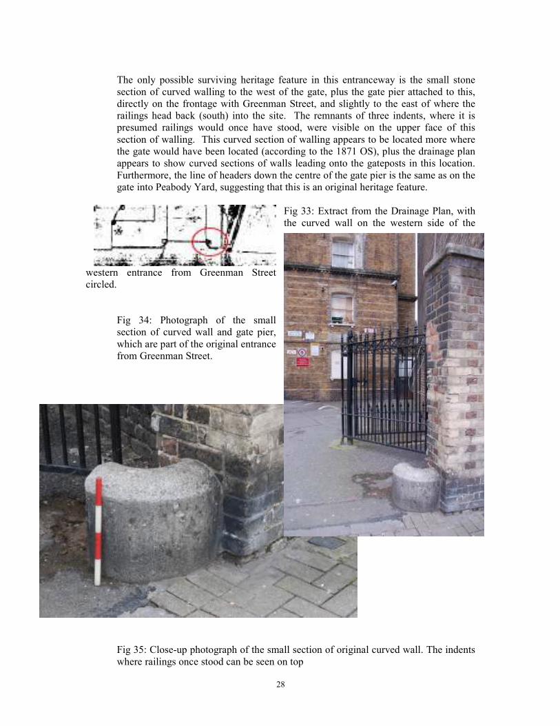
The only possible surviving heritage feature in this entranceway is the small stone
section of curved walling to the west of the gate, plus the gate pier attached to this,
directly on the frontage with Greenman Street, and slightly to the east of where the
railings head back (south) into the site. The remnants of three indents, where it is
presumed railings would once have stood, were visible on the upper face of this
section of walling. This curved section of walling appears to be located more where
the gate would have been located (according to the 1871 OS), plus the drainage plan
appears to show curved sections of walls leading onto the gateposts in this location.
Furthermore, the line of headers down the centre of the gate pier is the same as on the
gate into Peabody Yard, suggesting that this is an original heritage feature.
Fig 33: Extract from the Drainage Plan, with
the curved wall on the western side of the
western entrance from Greenman Street
circled.
Fig 34: Photograph of the small
section of curved wall and gate pier,
which are part of the original entrance
from Greenman Street.
Fig 35: Close-up photograph of the small section of original curved wall. The indents
where railings once stood can be seen on top
29
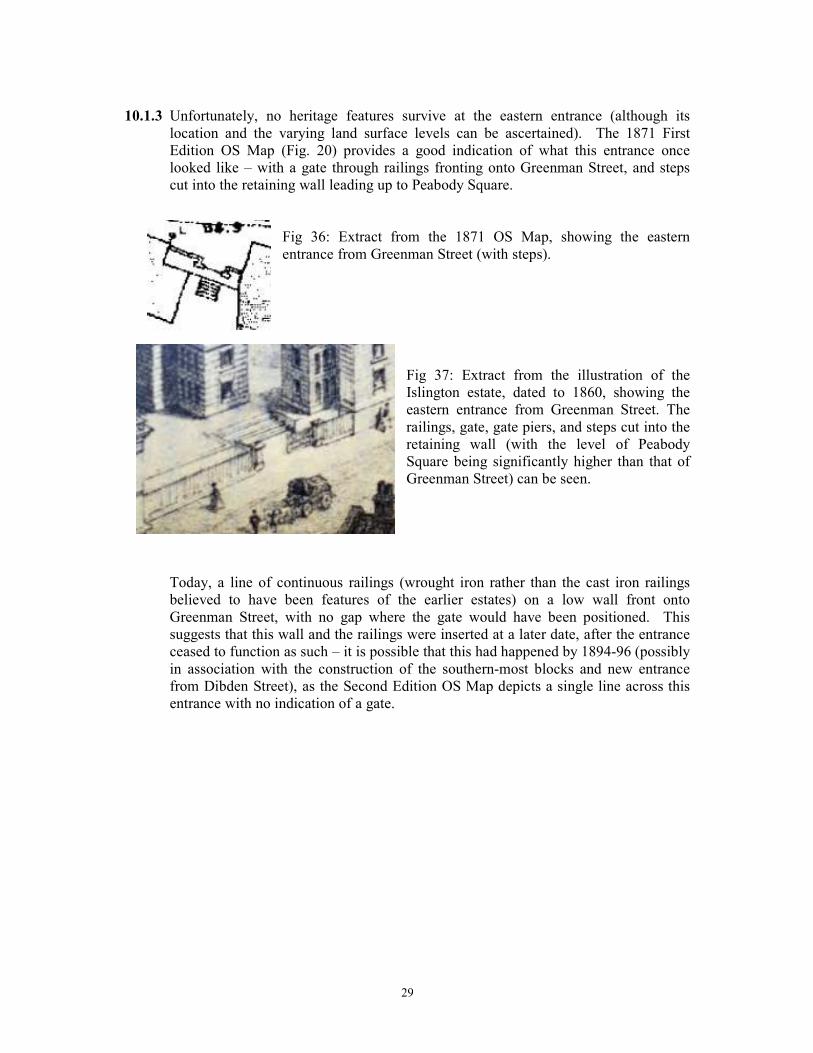
10.1.3 Unfortunately, no heritage features survive at the eastern entrance (although its
location and the varying land surface levels can be ascertained). The 1871 First
Edition OS Map (Fig. 20) provides a good indication of what this entrance once
looked like – with a gate through railings fronting onto Greenman Street, and steps
cut into the retaining wall leading up to Peabody Square.
Fig 36: Extract from the 1871 OS Map, showing the eastern
entrance from Greenman Street (with steps).
Fig 37: Extract from the illustration of the
Islington estate, dated to 1860, showing the
eastern entrance from Greenman Street. The
railings, gate, gate piers, and steps cut into the
retaining wall (with the level of Peabody
Square being significantly higher than that of
Greenman Street) can be seen.
Today, a line of continuous railings (wrought iron rather than the cast iron railings
believed to have been features of the earlier estates) on a low wall front onto
Greenman Street, with no gap where the gate would have been positioned. This
suggests that this wall and the railings were inserted at a later date, after the entrance
ceased to function as such – it is possible that this had happened by 1894-96 (possibly
in association with the construction of the southern-most blocks and new entrance
from Dibden Street), as the Second Edition OS Map depicts a single line across this
entrance with no indication of a gate.
30
Fig 38: Photograph of the eastern entrance from
Greenman Street today, looking out onto Greenman
Street. The replaced wall and railings can be seen.
Behind this was the retaining wall up to the higher level of Peabody Square. It is
believed that this does represent the original difference in land-levels between
Greenman Street and Peabody Square, although the lack of evidence for steps (which
were once cut into this wall) suggests that this wall is a new feature. Modern wooden
steps provide access up this, and another line of continuous railings (with a single gate
through them) is positioned at the top. This was all clearly inserted at a later date, as
it is entirely different from that recorded on the 1871 OS Map.
Fig 39: Photograph of the eastern entrance from
Greenman Street, looking in. The replaced wall
and railings, with the retaining wall behind, and
another line of replaced railings at the top, can
all be seen.
31
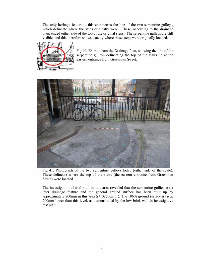
The only heritage feature at this entrance is the line of the two serpentine gulleys,
which delineate where the steps originally were. These, according to the drainage
plan, ended either side of the top of the original steps. The serpentine gulleys are still
visible, and this therefore shows exactly where these steps were originally located.
Fig 40: Extract from the Drainage Plan, showing the line of the
serpentine gulleys delineating the top of the stairs up at the
eastern entrance from Greenman Street.
Fig 41: Photograph of the two serpentine gulleys today (either side of the scale).
These delineate where the top of the stairs (the eastern entrance from Greenman
Street) were located.
The investigation of trial pit 1 in this area revealed that the serpentine gullies are a
later drainage feature and the general ground surface has been built up by
approximately 200mm in this area (cf. Section 11). The 1860s ground surface is circa
200mm lower than this level, as demonstrated by the low brick wall in investigative
test pit 1.
32
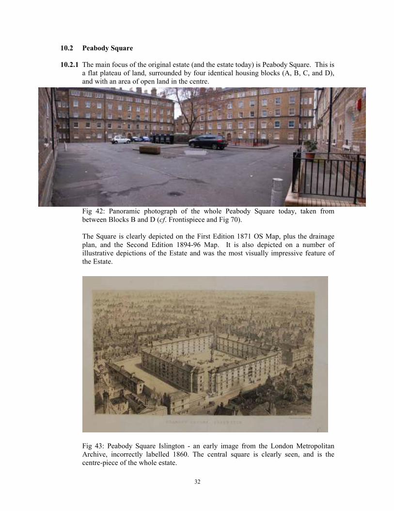
10.2 Peabody Square
10.2.1 The main focus of the original estate (and the estate today) is Peabody Square. This is
a flat plateau of land, surrounded by four identical housing blocks (A, B, C, and D),
and with an area of open land in the centre.
Fig 42: Panoramic photograph of the whole Peabody Square today, taken from
between Blocks B and D (cf. Frontispiece and Fig 70).
The Square is clearly depicted on the First Edition 1871 OS Map, plus the drainage
plan, and the Second Edition 1894-96 Map. It is also depicted on a number of
illustrative depictions of the Estate and was the most visually impressive feature of
the Estate.
Fig 43: Peabody Square Islington - an early image from the London Metropolitan
Archive, incorrectly labelled 1860. The central square is clearly seen, and is the
centre-piece of the whole estate.
33
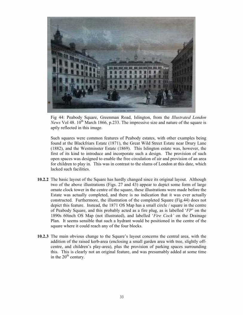
Fig 44: Peabody Square, Greenman Road, Islington, from the Illustrated London
News Vol 48. 10th March 1866, p.233. The impressive size and nature of the square is
aptly reflected in this image.
Such squares were common features of Peabody estates, with other examples being
found at the Blackfriars Estate (1871), the Great Wild Street Estate near Drury Lane
(1882), and the Westminster Estate (1869). This Islington estate was, however, the
first of its kind to introduce and incorporate such a design. The provision of such
open spaces was designed to enable the free circulation of air and provision of an area
for children to play in. This was in contrast to the slums of London at this date, which
lacked such facilities.
10.2.2 The basic layout of the Square has hardly changed since its original layout. Although
two of the above illustrations (Figs. 27 and 43) appear to depict some form of large
ornate clock tower in the centre of the square, these illustrations were made before the
Estate was actually completed, and there is no indication that it was ever actually
constructed. Furthermore, the illustration of the completed Square (Fig.44) does not
depict this feature. Instead, the 1871 OS Map has a small circle / square in the centre
of Peabody Square, and this probably acted as a fire plug, as is labelled ‘FP’ on the
1890s 60inch OS Map (not illustrated), and labelled ‘Fire Cock’ on the Drainage
Plan. It seems sensible that such a hydrant would be positioned in the centre of the
square where it could reach any of the four blocks.
10.2.3 The main obvious change to the Square’s layout concerns the central area, with the
addition of the raised kerb-area (enclosing a small garden area with tree, slightly off-
centre, and children’s play-area), plus the provision of parking spaces surrounding
this. This is clearly not an original feature, and was presumably added at some time
in the 20th century.
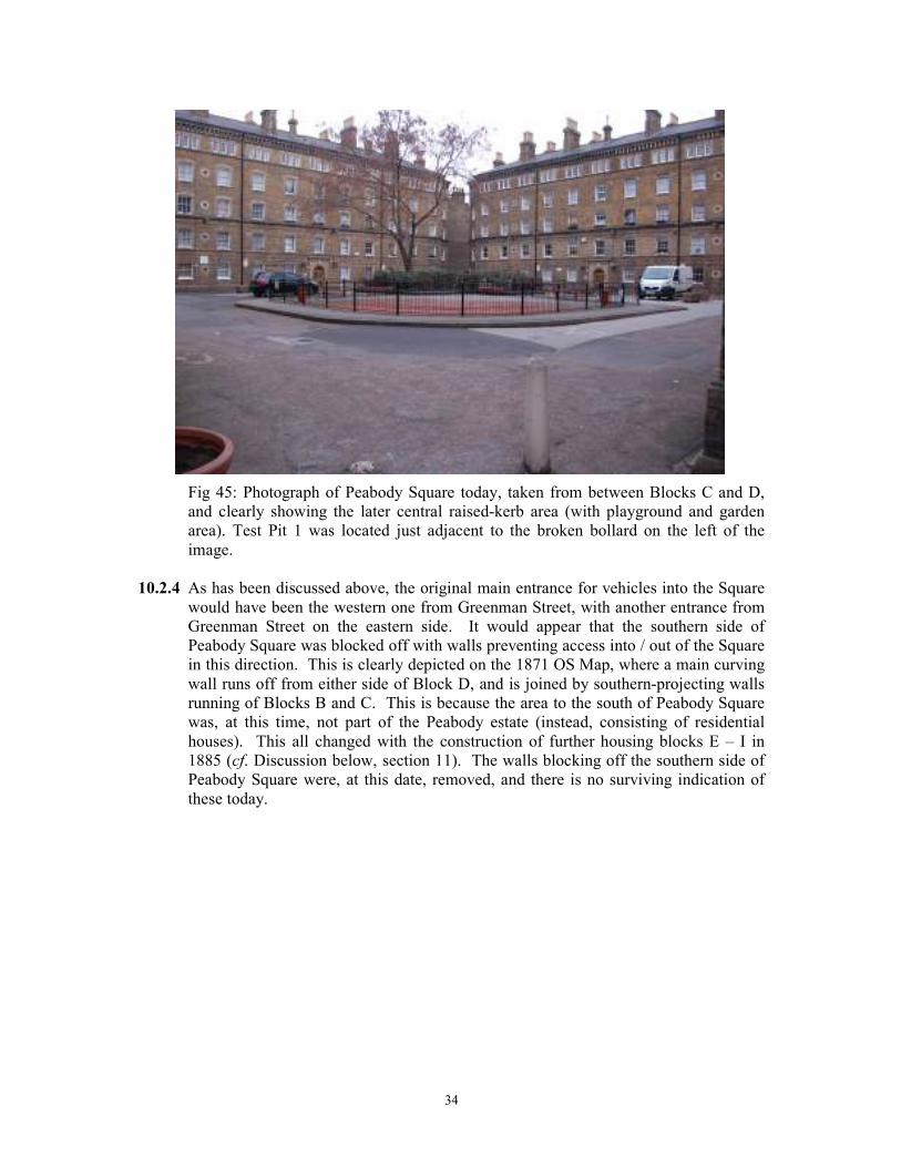
34
Fig 45: Photograph of Peabody Square today, taken from between Blocks C and D,
and clearly showing the later central raised-kerb area (with playground and garden
area). Test Pit 1 was located just adjacent to the broken bollard on the left of the
image.
10.2.4 As has been discussed above, the original main entrance for vehicles into the Square
would have been the western one from Greenman Street, with another entrance from
Greenman Street on the eastern side. It would appear that the southern side of
Peabody Square was blocked off with walls preventing access into / out of the Square
in this direction. This is clearly depicted on the 1871 OS Map, where a main curving
wall runs off from either side of Block D, and is joined by southern-projecting walls
running of Blocks B and C. This is because the area to the south of Peabody Square
was, at this time, not part of the Peabody estate (instead, consisting of residential
houses). This all changed with the construction of further housing blocks E – I in
1885 (cf. Discussion below, section 11). The walls blocking off the southern side of
Peabody Square were, at this date, removed, and there is no surviving indication of
these today.
35
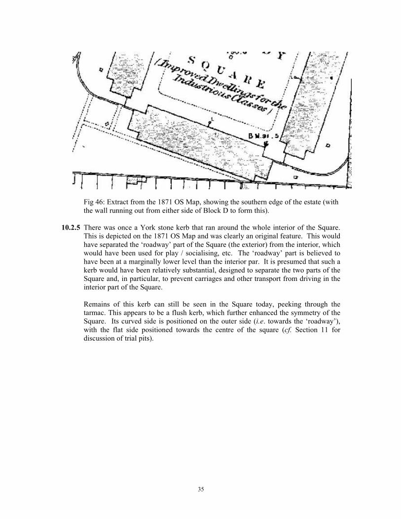
Fig 46: Extract from the 1871 OS Map, showing the southern edge of the estate (with
the wall running out from either side of Block D to form this).
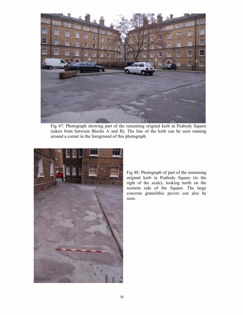
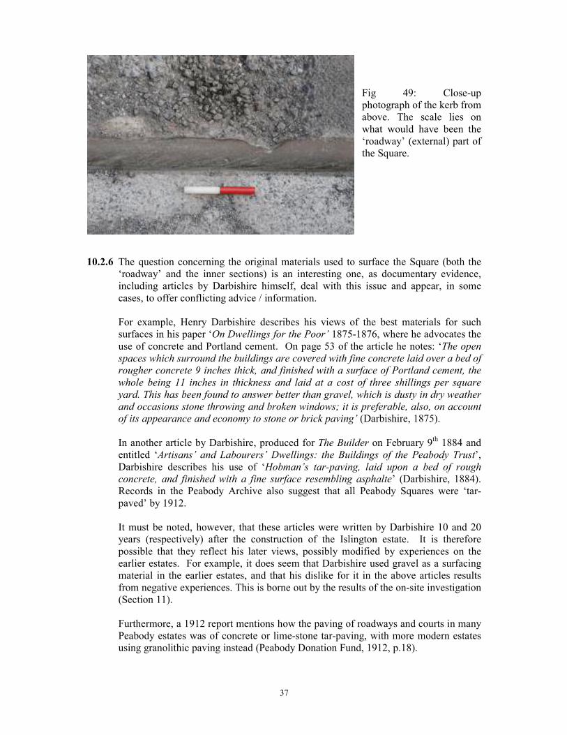
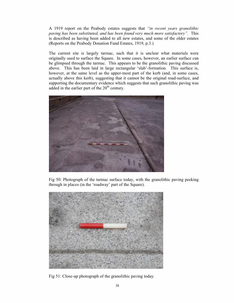
10.2.5 There was once a York stone kerb that ran around the whole interior of the Square.
This is depicted on the 1871 OS Map and was clearly an original feature. This would
have separated the ‘roadway’ part of the Square (the exterior) from the interior, which
would have been used for play / socialising, etc. The ‘roadway’ part is believed to
have been at a marginally lower level than the interior par. It is presumed that such a
kerb would have been relatively substantial, designed to separate the two parts of the
Square and, in particular, to prevent carriages and other transport from driving in the
interior part of the Square.
Remains of this kerb can still be seen in the Square today, peeking through the
tarmac. This appears to be a flush kerb, which further enhanced the symmetry of the
Square. Its curved side is positioned on the outer side (i.e. towards the ‘roadway’),
with the flat side positioned towards the centre of the square (cf. Section 11 for
discussion of trial pits).
36
Fig 47: Photograph showing part of the remaining original kerb in Peabody Square
(taken from between Blocks A and B). The line of the kerb can be seen running
around a corner in the foreground of this photograph.
Fig 48: Photograph of part of the remaining
original kerb in Peabody Square (to the
right of the scale), looking north on the
western side of the Square. The large
concrete granolithic pavers can also be
seen.
37
Fig 49: Close-up
photograph of the kerb from
above. The scale lies on
what would have been the
‘roadway’ (external) part of
the Square.
10.2.6 The question concerning the original materials used to surface the Square (both the
‘roadway’ and the inner sections) is an interesting one, as documentary evidence,
including articles by Darbishire himself, deal with this issue and appear, in some
cases, to offer conflicting advice / information.
For example, Henry Darbishire describes his views of the best materials for such
surfaces in his paper ‘On Dwellings for the Poor’ 1875-1876, where he advocates the
use of concrete and Portland cement. On page 53 of the article he notes: ‘The open
spaces which surround the buildings are covered with fine concrete laid over a bed of
rougher concrete 9 inches thick, and finished with a surface of Portland cement, the
whole being 11 inches in thickness and laid at a cost of three shillings per square
yard. This has been found to answer better than gravel, which is dusty in dry weather
and occasions stone throwing and broken windows; it is preferable, also, on account
of its appearance and economy to stone or brick paving’ (Darbishire, 1875).
In another article by Darbishire, produced for The Builder on February 9th 1884 and
entitled ‘Artisans’ and Labourers’ Dwellings: the Buildings of the Peabody Trust’,
Darbishire describes his use of ‘Hobman’s tar-paving, laid upon a bed of rough
concrete, and finished with a fine surface resembling asphalte’ (Darbishire, 1884).
Records in the Peabody Archive also suggest that all Peabody Squares were ‘tar-
paved’ by 1912.
It must be noted, however, that these articles were written by Darbishire 10 and 20
years (respectively) after the construction of the Islington estate. It is therefore
possible that they reflect his later views, possibly modified by experiences on the
earlier estates. For example, it does seem that Darbishire used gravel as a surfacing
material in the earlier estates, and that his dislike for it in the above articles results
from negative experiences. This is borne out by the results of the on-site investigation
(Section 11).
Furthermore, a 1912 report mentions how the paving of roadways and courts in many
Peabody estates was of concrete or lime-stone tar-paving, with more modern estates
using granolithic paving instead (Peabody Donation Fund, 1912, p.18).
38
A 1919 report on the Peabody estates suggests that “in recent years granolithic
paving has been substituted, and has been found very much more satisfactory”. This
is described as having been added to all new estates, and some of the older estates
(Reports on the Peabody Donation Fund Estates, 1919, p.3.)
The current site is largely tarmac, such that it is unclear what materials were
originally used to surface the Square. In some cases, however, an earlier surface can
be glimpsed through the tarmac. This appears to be the granolithic paving discussed
above. This has been laid in large rectangular ‘slab’-formation. This surface is,
however, at the same level as the upper-most part of the kerb (and, in some cases,
actually above this kerb), suggesting that it cannot be the original road-surface, and
supporting the documentary evidence which suggests that such granolithic paving was
added in the earlier part of the 20th century.
Fig 50: Photograph of the tarmac surface today, with the granolithic paving peeking
through in places (in the ‘roadway’ part of the Square).
Fig 51: Close-up photograph of the granolithic paving today.
39
It was not, therefore, clear from a visual inspection of the site what the original
materials used to surface the ‘roadway’ part of the Square were. There was also no
visible evidence for the original materials used to surface the interior part of Peabody
Square, with this being completely set over to tarmac, the garden and the play area.
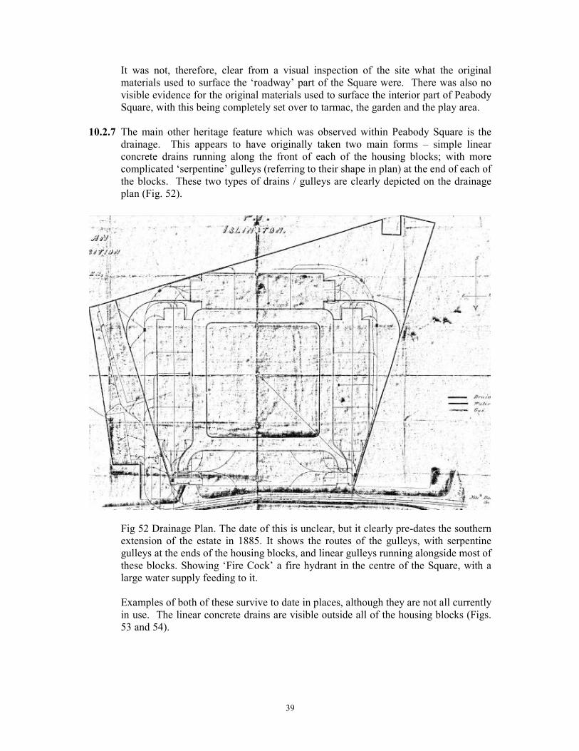
10.2.7 The main other heritage feature which was observed within Peabody Square is the
drainage. This appears to have originally taken two main forms – simple linear
concrete drains running along the front of each of the housing blocks; with more
complicated ‘serpentine’ gulleys (referring to their shape in plan) at the end of each of
the blocks. These two types of drains / gulleys are clearly depicted on the drainage
plan (Fig. 52).
Fig 52 Drainage Plan. The date of this is unclear, but it clearly pre-dates the southern
extension of the estate in 1885. It shows the routes of the gulleys, with serpentine
gulleys at the ends of the housing blocks, and linear gulleys running alongside most of
these blocks. Showing ‘Fire Cock’ a fire hydrant in the centre of the Square, with a
large water supply feeding to it.
Examples of both of these survive to date in places, although they are not all currently
in use. The linear concrete drains are visible outside all of the housing blocks (Figs.
53 and 54).
40
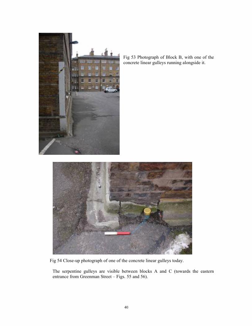
Fig 53 Photograph of Block B, with one of the
concrete linear gulleys running alongside it.
Fig 54 Close-up photograph of one of the concrete linear gulleys today.
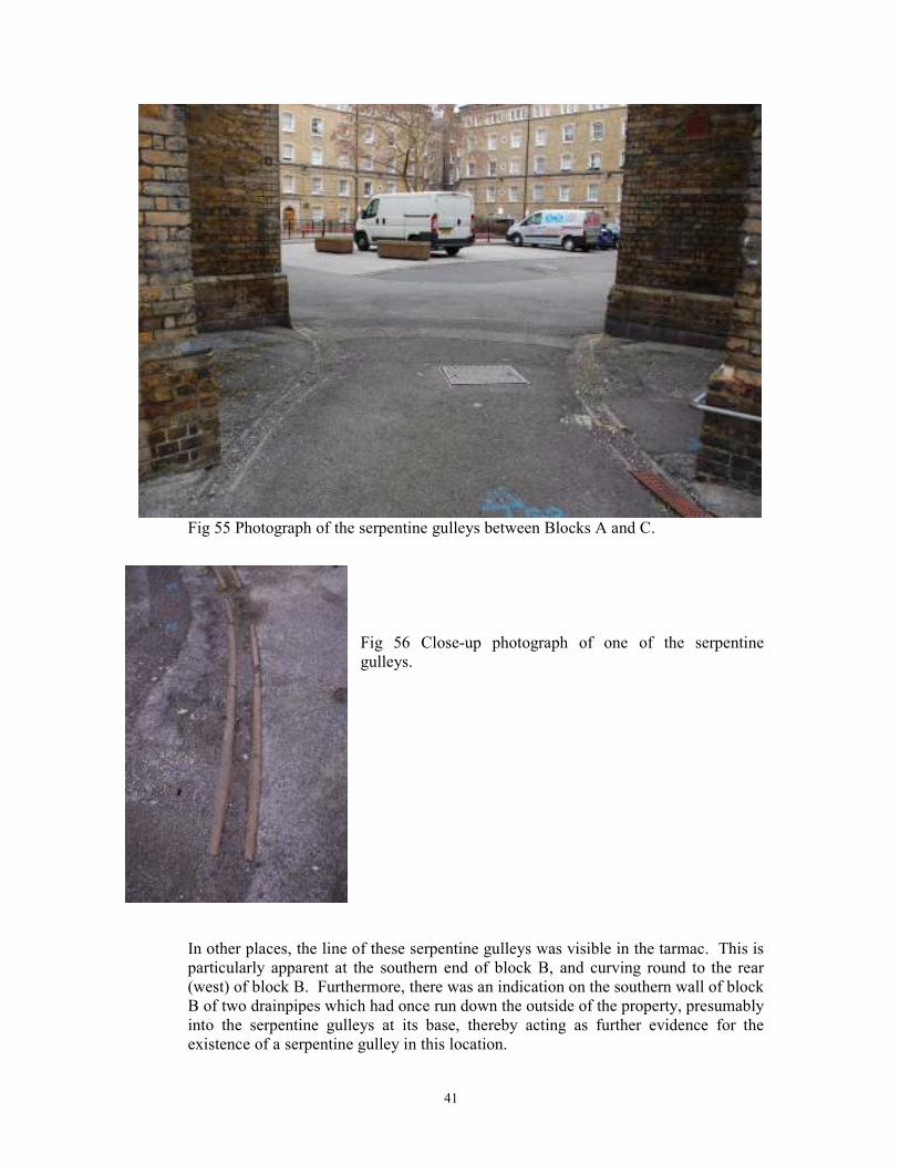
The serpentine gulleys are visible between blocks A and C (towards the eastern
entrance from Greenman Street – Figs. 55 and 56).
41
Fig 55 Photograph of the serpentine gulleys between Blocks A and C.
Fig 56 Close-up photograph of one of the serpentine
gulleys.
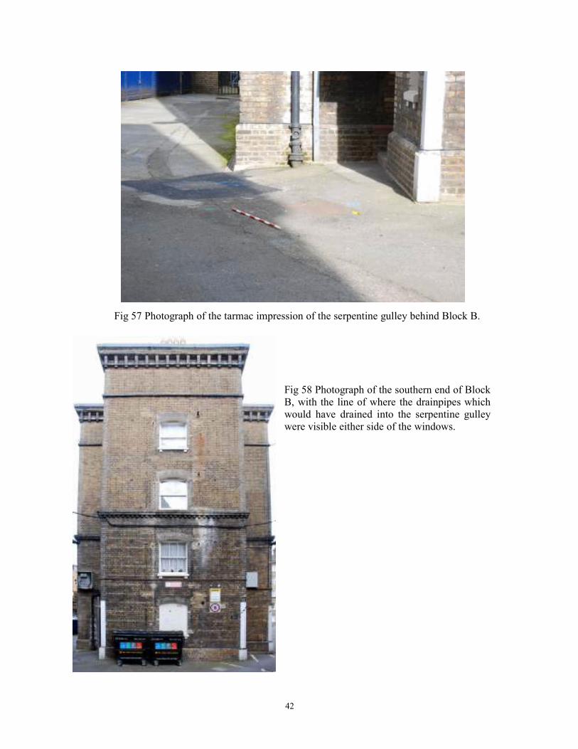
In other places, the line of these serpentine gulleys was visible in the tarmac. This is
particularly apparent at the southern end of block B, and curving round to the rear
(west) of block B. Furthermore, there was an indication on the southern wall of block
B of two drainpipes which had once run down the outside of the property, presumably
into the serpentine gulleys at its base, thereby acting as further evidence for the
existence of a serpentine gulley in this location.
42
Fig 57 Photograph of the tarmac impression of the serpentine gulley behind Block B.
Fig 58 Photograph of the southern end of Block
B, with the line of where the drainpipes which
would have drained into the serpentine gulley
were visible either side of the windows.
43
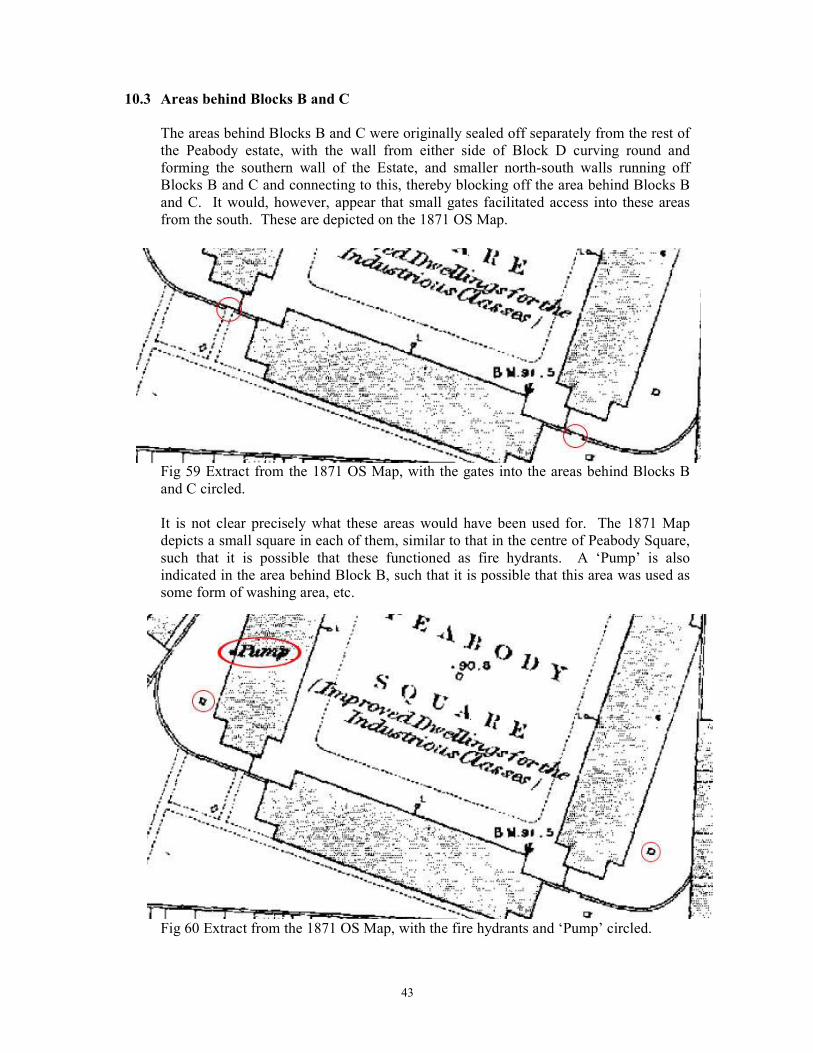
10.3 Areas behind Blocks B and C
The areas behind Blocks B and C were originally sealed off separately from the rest of
the Peabody estate, with the wall from either side of Block D curving round and
forming the southern wall of the Estate, and smaller north-south walls running off
Blocks B and C and connecting to this, thereby blocking off the area behind Blocks B
and C. It would, however, appear that small gates facilitated access into these areas
from the south. These are depicted on the 1871 OS Map.
Fig 59 Extract from the 1871 OS Map, with the gates into the areas behind Blocks B
and C circled.
It is not clear precisely what these areas would have been used for. The 1871 Map
depicts a small square in each of them, similar to that in the centre of Peabody Square,
such that it is possible that these functioned as fire hydrants. A ‘Pump’ is also
indicated in the area behind Block B, such that it is possible that this area was used as
some form of washing area, etc.
Fig 60 Extract from the 1871 OS Map, with the fire hydrants and ‘Pump’ circled.
44
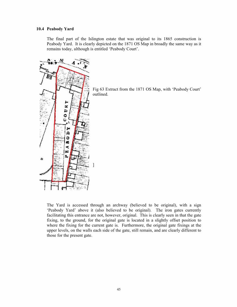
Interestingly, and somewhat confusingly, the land-surface level in the area behind
Block C rises very steeply to the north. It appears that the northern-most part of this
area has been built up, probably at the same time as Peabody Square was built up,
although it is unclear why this may have been undertaken.
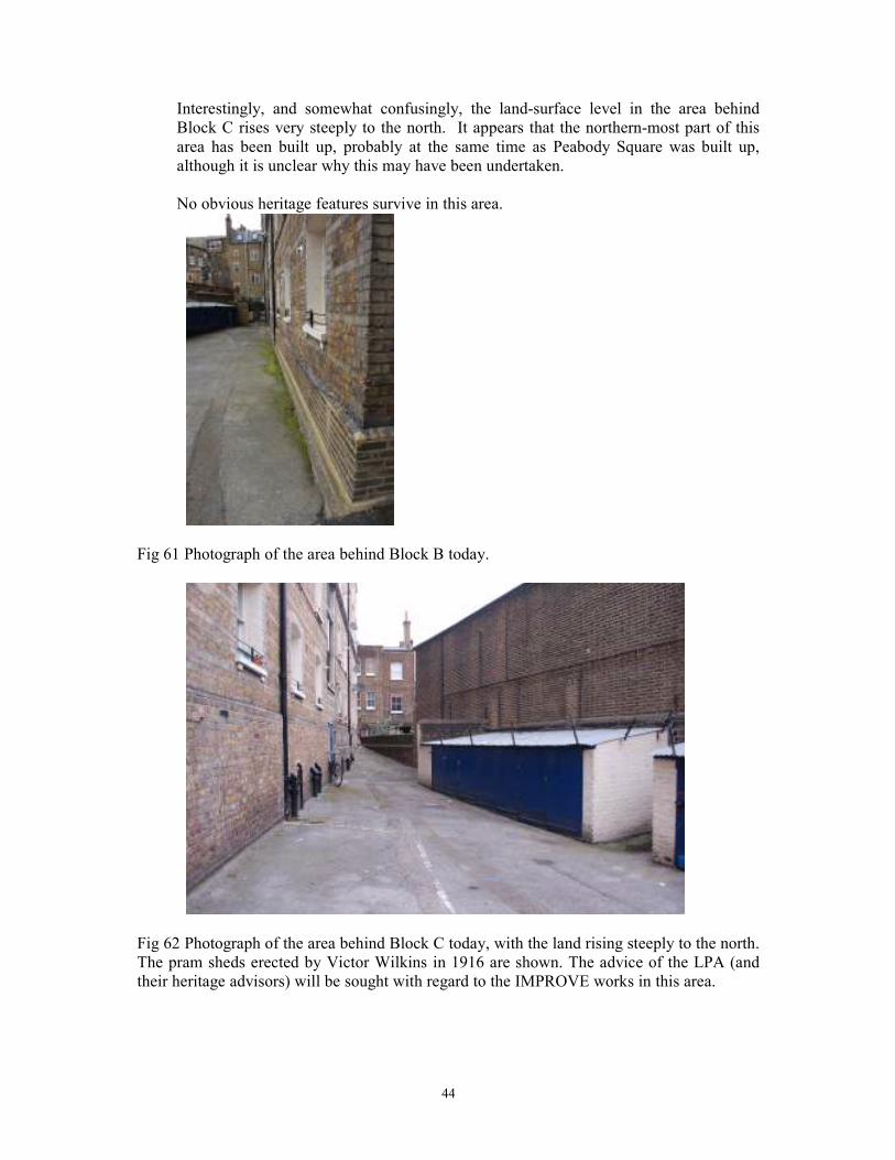
No obvious heritage features survive in this area.
Fig 61 Photograph of the area behind Block B today.
Fig 62 Photograph of the area behind Block C today, with the land rising steeply to the north.
The pram sheds erected by Victor Wilkins in 1916 are shown. The advice of the LPA (and
their heritage advisors) will be sought with regard to the IMPROVE works in this area.
45
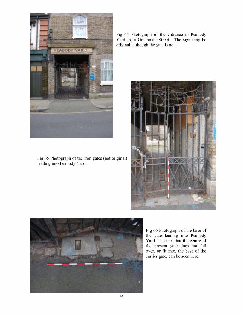
10.4 Peabody Yard
The final part of the Islington estate that was original to its 1865 construction is
Peabody Yard. It is clearly depicted on the 1871 OS Map in broadly the same way as it
remains today, although is entitled ‘Peabody Court’.
Fig 63 Extract from the 1871 OS Map, with ‘Peabody Court’
outlined.
]
The Yard is accessed through an archway (believed to be original), with a sign
‘Peabody Yard’ above it (also believed to be original). The iron gates currently
facilitating this entrance are not, however, original. This is clearly seen in that the gate
fixing, to the ground, for the original gate is located in a slightly offset position to
where the fixing for the current gate is. Furthermore, the original gate fixings at the
upper levels, on the walls each side of the gate, still remain, and are clearly different to
those for the present gate.
46
Fig 64 Photograph of the entrance to Peabody
Yard from Greenman Street. The sign may be
original, although the gate is not.
Fig 65 Photograph of the iron gates (not original)
leading into Peabody Yard.
Fig 66 Photograph of the base of
the gate leading into Peabody
Yard. The fact that the centre of
the present gate does not fall
over, or fit into, the base of the
earlier gate, can be seen here.
47
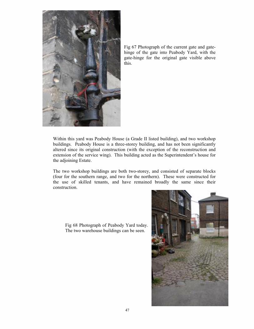
Fig 67 Photograph of the current gate and gate-
hinge of the gate into Peabody Yard, with the
gate-hinge for the original gate visible above
this.
Within this yard was Peabody House (a Grade II listed building), and two workshop
buildings. Peabody House is a three-storey building, and has not been significantly
altered since its original construction (with the exception of the reconstruction and
extension of the service wing). This building acted as the Superintendent’s house for
the adjoining Estate.
The two workshop buildings are both two-storey, and consisted of separate blocks
(four for the southern range, and two for the northern). These were constructed for
the use of skilled tenants, and have remained broadly the same since their
construction.
Fig 68 Photograph of Peabody Yard today.
The two warehouse buildings can be seen.
48
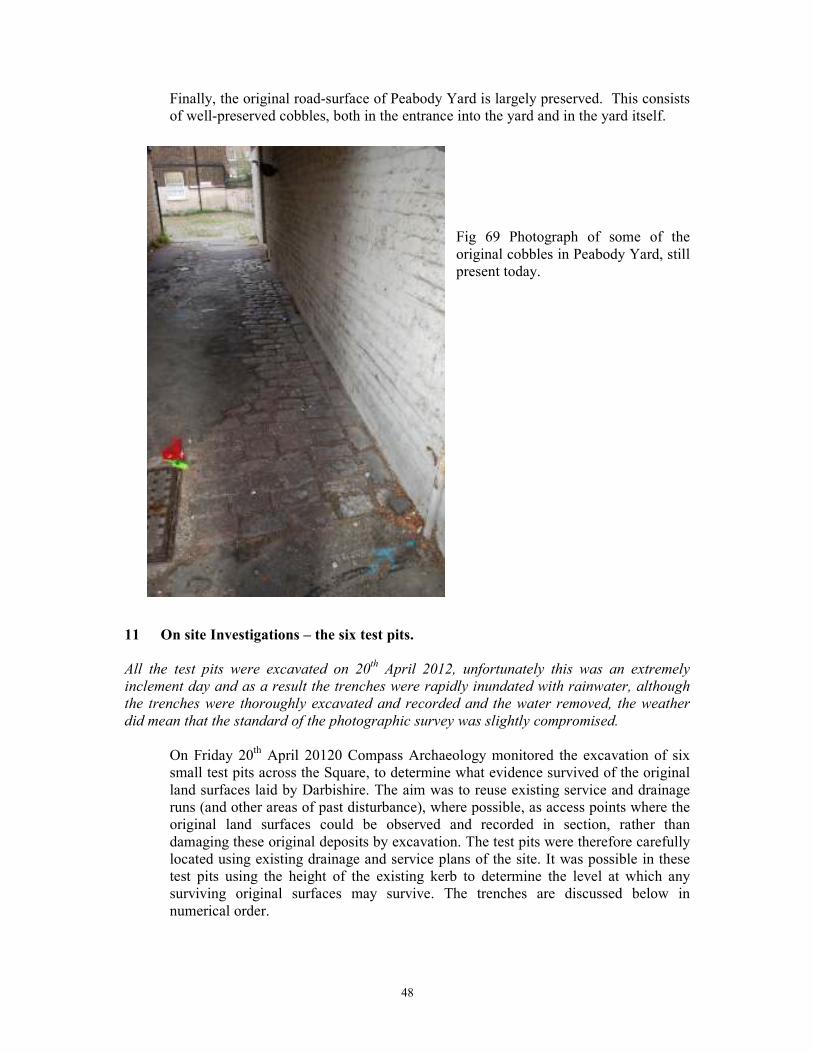
Finally, the original road-surface of Peabody Yard is largely preserved. This consists
of well-preserved cobbles, both in the entrance into the yard and in the yard itself.
Fig 69 Photograph of some of the
original cobbles in Peabody Yard, still
present today.
11 On site Investigations – the six test pits.
All the test pits were excavated on 20th April 2012, unfortunately this was an extremely
inclement day and as a result the trenches were rapidly inundated with rainwater, although
the trenches were thoroughly excavated and recorded and the water removed, the weather
did mean that the standard of the photographic survey was slightly compromised.
On Friday 20th April 20120 Compass Archaeology monitored the excavation of six
small test pits across the Square, to determine what evidence survived of the original
land surfaces laid by Darbishire. The aim was to reuse existing service and drainage
runs (and other areas of past disturbance), where possible, as access points where the
original land surfaces could be observed and recorded in section, rather than
damaging these original deposits by excavation. The test pits were therefore carefully
located using existing drainage and service plans of the site. It was possible in these
test pits using the height of the existing kerb to determine the level at which any
surviving original surfaces may survive. The trenches are discussed below in
numerical order.
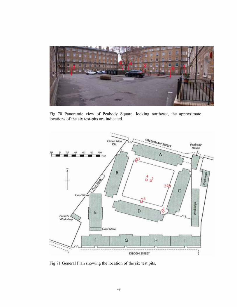
49
Fig 70 Panoramic view of Peabody Square, looking northeast, the approximate
locations of the six test-pits are indicated.
Fig 71 General Plan showing the location of the six test pits.
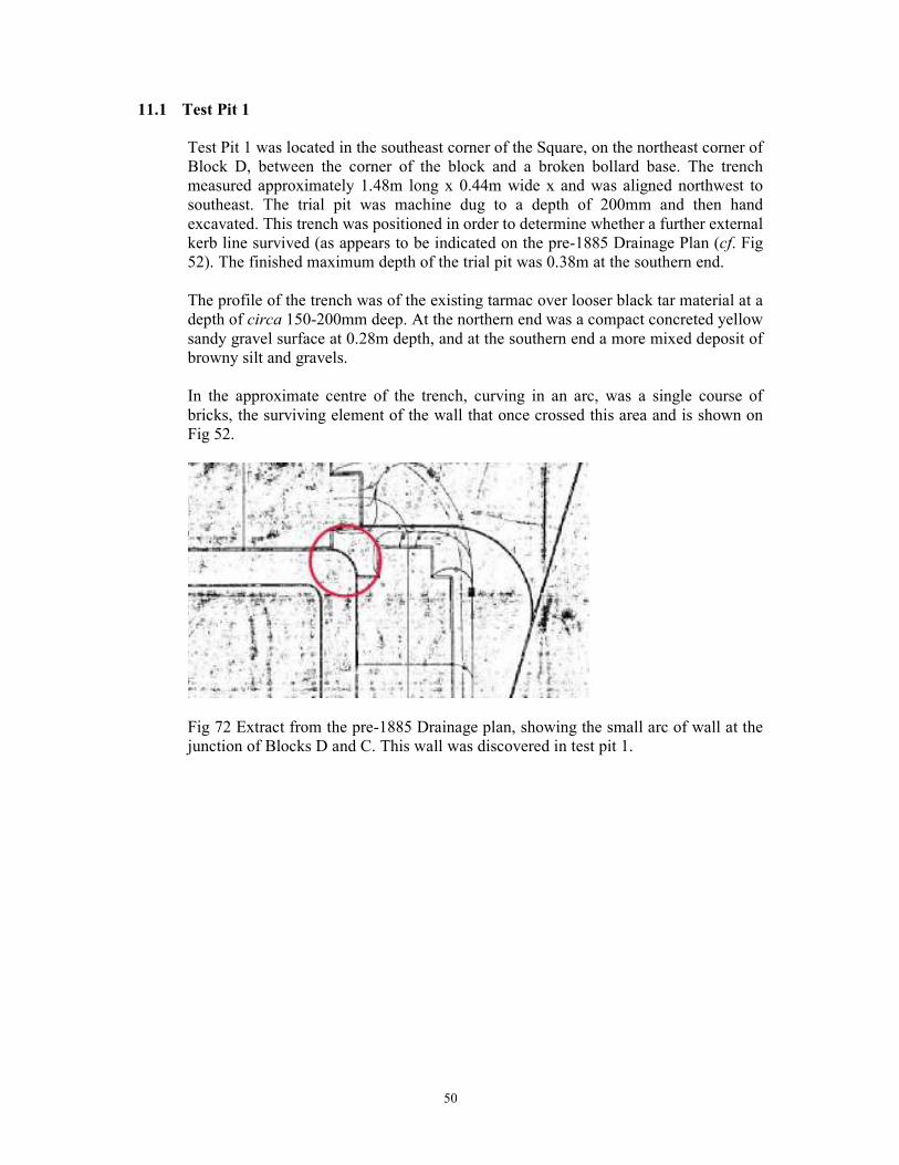
50
11.1 Test Pit 1
Test Pit 1 was located in the southeast corner of the Square, on the northeast corner of
Block D, between the corner of the block and a broken bollard base. The trench
measured approximately 1.48m long x 0.44m wide x and was aligned northwest to
southeast. The trial pit was machine dug to a depth of 200mm and then hand
excavated. This trench was positioned in order to determine whether a further external
kerb line survived (as appears to be indicated on the pre-1885 Drainage Plan (cf. Fig
52). The finished maximum depth of the trial pit was 0.38m at the southern end.
The profile of the trench was of the existing tarmac over looser black tar material at a
depth of circa 150-200mm deep. At the northern end was a compact concreted yellow
sandy gravel surface at 0.28m depth, and at the southern end a more mixed deposit of
browny silt and gravels.
In the approximate centre of the trench, curving in an arc, was a single course of
bricks, the surviving element of the wall that once crossed this area and is shown on
Fig 52.
Fig 72 Extract from the pre-1885 Drainage plan, showing the small arc of wall at the
junction of Blocks D and C. This wall was discovered in test pit 1.
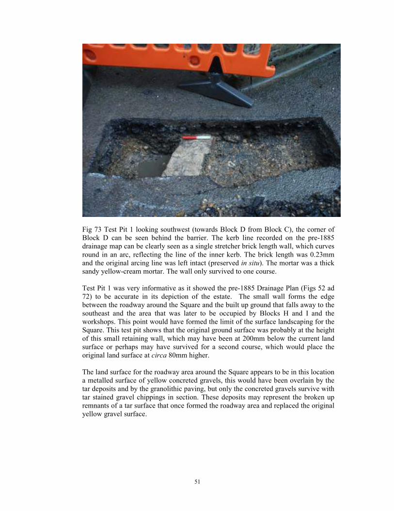
51
Fig 73 Test Pit 1 looking southwest (towards Block D from Block C), the corner of
Block D can be seen behind the barrier. The kerb line recorded on the pre-1885
drainage map can be clearly seen as a single stretcher brick length wall, which curves
round in an arc, reflecting the line of the inner kerb. The brick length was 0.23mm
and the original arcing line was left intact (preserved in situ). The mortar was a thick
sandy yellow-cream mortar. The wall only survived to one course.
Test Pit 1 was very informative as it showed the pre-1885 Drainage Plan (Figs 52 ad
72) to be accurate in its depiction of the estate. The small wall forms the edge
between the roadway around the Square and the built up ground that falls away to the
southeast and the area that was later to be occupied by Blocks H and I and the
workshops. This point would have formed the limit of the surface landscaping for the
Square. This test pit shows that the original ground surface was probably at the height
of this small retaining wall, which may have been at 200mm below the current land
surface or perhaps may have survived for a second course, which would place the
original land surface at circa 80mm higher.
The land surface for the roadway area around the Square appears to be in this location
a metalled surface of yellow concreted gravels, this would have been overlain by the
tar deposits and by the granolithic paving, but only the concreted gravels survive with
tar stained gravel chippings in section. These deposits may represent the broken up
remnants of a tar surface that once formed the roadway area and replaced the original
yellow gravel surface.
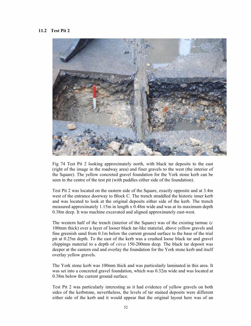
52
11.2 Test Pit 2
Fig 74 Test Pit 2 looking approximately north, with black tar deposits to the east
(right of the image in the roadway area) and finer gravels to the west (the interior of
the Square). The yellow concreted gravel foundation for the York stone kerb can be
seen in the centre of the test pit (with puddles either side of the foundation).
Test Pit 2 was located on the eastern side of the Square, exactly opposite and at 3.4m
west of the entrance doorway to Block C. The trench straddled the historic inner kerb
and was located to look at the original deposits either side of the kerb. The trench
measured approximately 1.15m in length x 0.48m wide and was at its maximum depth
0.38m deep. It was machine excavated and aligned approximately east-west.
The western half of the trench (interior of the Square) was of the existing tarmac (c
100mm thick) over a layer of looser black tar-like material, above yellow gravels and
fine greenish sand from 0.1m below the current ground surface to the base of the trial
pit at 0.25m depth. To the east of the kerb was a crushed loose black tar and gravel
chippings material to a depth of circa 150-200mm deep. The black tar deposit was
deeper at the eastern end and overlay the foundation for the York stone kerb and itself
overlay yellow gravels.
The York stone kerb was 100mm thick and was particularly laminated in this area. It
was set into a concreted gravel foundation, which was 0.32m wide and was located at
0.38m below the current ground surface.
Test Pit 2 was particularly interesting as it had evidence of yellow gravels on both
sides of the kerbstone, nevertheless, the levels of tar stained deposits were different
either side of the kerb and it would appear that the original layout here was of an
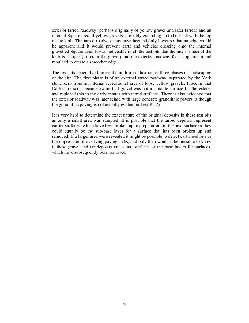
53
exterior tarred roadway (perhaps originally of yellow gravel and later tarred) and an
internal Square area of yellow gravels, probably extending up to be flush with the top
of the kerb. The tarred roadway may have been slightly lower so that an edge would
be apparent and it would prevent carts and vehicles crossing onto the internal
gravelled Square area. It was noticeable in all the test pits that the interior face of the
kerb is sharper (to retain the gravel) and the exterior roadway face is quarter round
moulded to create a smoother edge.
The test pits generally all present a uniform indication of three phases of landscaping
of the site. The first phase is of an external tarred roadway, separated by the York
stone kerb from an internal recreational area of loose yellow gravels. It seems that
Darbishire soon became aware that gravel was not a suitable surface for the estates
and replaced this in the early estates with tarred surfaces. There is also evidence that
the exterior roadway was later relaid with large concrete granolithic pavers (although
the granolithic paving is not actually evident in Test Pit 2).
It is very hard to determine the exact nature of the original deposits in these test pits
as only a small area was sampled. It is possible that the tarred deposits represent
earlier surfaces, which have been broken up in preparation for the next surface or they
could equally be the sub-base layer for a surface that has been broken up and
removed. If a larger area were revealed it might be possible to detect cartwheel ruts or
the impression of overlying paving slabs, and only then would it be possible to know
if these gravel and tar deposits are actual surfaces or the base layers for surfaces,
which have subsequently been removed.
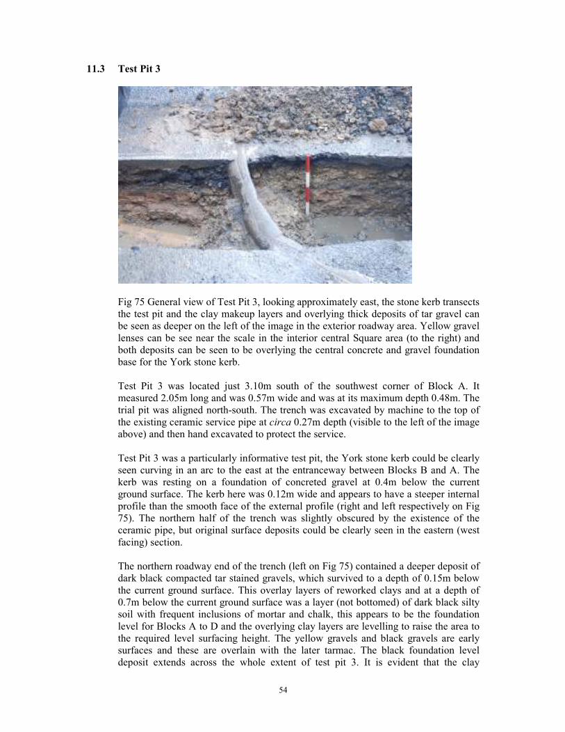
54
11.3 Test Pit 3
Fig 75 General view of Test Pit 3, looking approximately east, the stone kerb transects
the test pit and the clay makeup layers and overlying thick deposits of tar gravel can
be seen as deeper on the left of the image in the exterior roadway area. Yellow gravel
lenses can be see near the scale in the interior central Square area (to the right) and
both deposits can be seen to be overlying the central concrete and gravel foundation
base for the York stone kerb.
Test Pit 3 was located just 3.10m south of the southwest corner of Block A. It
measured 2.05m long and was 0.57m wide and was at its maximum depth 0.48m. The
trial pit was aligned north-south. The trench was excavated by machine to the top of
the existing ceramic service pipe at circa 0.27m depth (visible to the left of the image
above) and then hand excavated to protect the service.
Test Pit 3 was a particularly informative test pit, the York stone kerb could be clearly
seen curving in an arc to the east at the entranceway between Blocks B and A. The
kerb was resting on a foundation of concreted gravel at 0.4m below the current
ground surface. The kerb here was 0.12m wide and appears to have a steeper internal
profile than the smooth face of the external profile (right and left respectively on Fig
75). The northern half of the trench was slightly obscured by the existence of the
ceramic pipe, but original surface deposits could be clearly seen in the eastern (west
facing) section.
The northern roadway end of the trench (left on Fig 75) contained a deeper deposit of
dark black compacted tar stained gravels, which survived to a depth of 0.15m below
the current ground surface. This overlay layers of reworked clays and at a depth of
0.7m below the current ground surface was a layer (not bottomed) of dark black silty
soil with frequent inclusions of mortar and chalk, this appears to be the foundation
level for Blocks A to D and the overlying clay layers are levelling to raise the area to
the required level surfacing height. The yellow gravels and black gravels are early
surfaces and these are overlain with the later tarmac. The black foundation level
deposit extends across the whole extent of test pit 3. It is evident that the clay
55
levelling layers overly the foundation base for the kerb wall and that the area was
built up in this northwest corner when the Estate was built.
11.4 Test Pit 4
Test Pit 4 was hand excavated in the central garden area of the Square. It measured
0.55m in length x 0.36m wide x 0.42m deep. The fill was a standard garden soil with
numerous roots. It is likely that this deposit was imported when the shrubbery area
was created. It survived as a homogenous layer to the base of the pit. The trench was
located at 0.45m west of the eastern most wall of the central garden area.
The footings of the low-lying play area wall were revealed in the western side of the
test pit at circa 0.46m below current ground surface. No heritage features or finds
were encountered in Test Pit 4.
Fig 76 General view of Test Pit 4, looking approximately east. The wall to the left is the
southern wall of the garden area, in the area to the east where it runs alongside the
play area.
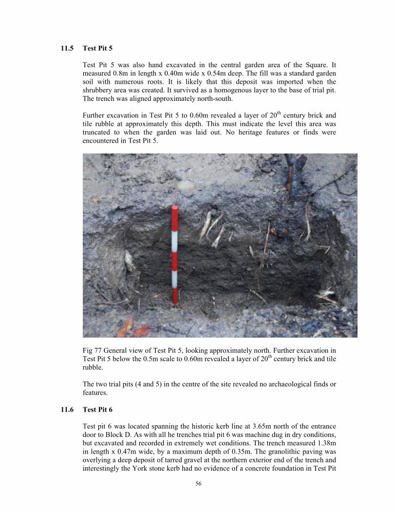
56
11.5 Test Pit 5
Test Pit 5 was also hand excavated in the central garden area of the Square. It
measured 0.8m in length x 0.40m wide x 0.54m deep. The fill was a standard garden
soil with numerous roots. It is likely that this deposit was imported when the
shrubbery area was created. It survived as a homogenous layer to the base of trial pit.
The trench was aligned approximately north-south.
Further excavation in Test Pit 5 to 0.60m revealed a layer of 20th century brick and
tile rubble at approximately this depth. This must indicate the level this area was
truncated to when the garden was laid out. No heritage features or finds were
encountered in Test Pit 5.
Fig 77 General view of Test Pit 5, looking approximately north. Further excavation in
Test Pit 5 below the 0.5m scale to 0.60m revealed a layer of 20th century brick and tile
rubble.
The two trial pits (4 and 5) in the centre of the site revealed no archaeological finds or
features.
11.6 Test Pit 6
Test pit 6 was located spanning the historic kerb line at 3.65m north of the entrance
door to Block D. As with all he trenches trial pit 6 was machine dug in dry conditions,
but excavated and recorded in extremely wet conditions. The trench measured 1.38m
in length x 0.47m wide, by a maximum depth of 0.35m. The granolithic paving was
overlying a deep deposit of tarred gravel at the northern exterior end of the trench and
interestingly the York stone kerb had no evidence of a concrete foundation in Test Pit
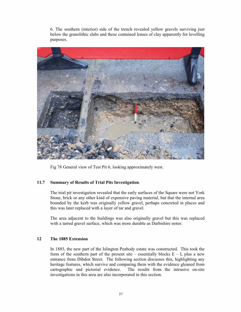
57
6. The southern (interior) side of the trench revealed yellow gravels surviving just
below the granolithic slabs and these contained lenses of clay apparently for levelling
purposes.
Fig 78 General view of Test Pit 6, looking approximately west.
11.7 Summary of Results of Trial Pits Investigation.
The trial pit investigation revealed that the early surfaces of the Square were not York
Stone, brick or any other kind of expensive paving material, but that the internal area
bounded by the kerb was originally yellow gravel, perhaps concreted in places and
this was later replaced with a layer of tar and gravel.
The area adjacent to the buildings was also originally gravel but this was replaced
with a tarred gravel surface, which was more durable as Darbishire notes:
12 The 1885 Extension
In 1885, the new part of the Islington Peabody estate was constructed. This took the
form of the southern part of the present site – essentially blocks E – I, plus a new
entrance from Dibden Street. The following section discusses this, highlighting any
heritage features, which survive and comparing them with the evidence gleaned from
cartographic and pictorial evidence. The results from the intrusive on-site
investigations in this area are also incorporated in this section.
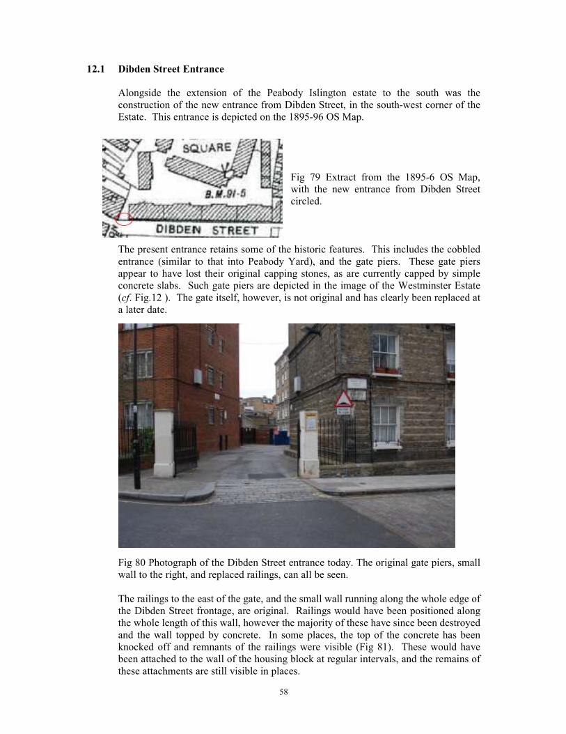
58
12.1 Dibden Street Entrance
Alongside the extension of the Peabody Islington estate to the south was the
construction of the new entrance from Dibden Street, in the south-west corner of the
Estate. This entrance is depicted on the 1895-96 OS Map.
Fig 79 Extract from the 1895-6 OS Map,
with the new entrance from Dibden Street
circled.
The present entrance retains some of the historic features. This includes the cobbled
entrance (similar to that into Peabody Yard), and the gate piers. These gate piers
appear to have lost their original capping stones, as are currently capped by simple
concrete slabs. Such gate piers are depicted in the image of the Westminster Estate
(cf. Fig.12 ). The gate itself, however, is not original and has clearly been replaced at
a later date.
Fig 80 Photograph of the Dibden Street entrance today. The original gate piers, small
wall to the right, and replaced railings, can all be seen.
The railings to the east of the gate, and the small wall running along the whole edge of
the Dibden Street frontage, are original. Railings would have been positioned along
the whole length of this wall, however the majority of these have since been destroyed
and the wall topped by concrete. In some places, the top of the concrete has been
knocked off and remnants of the railings were visible (Fig 81). These would have
been attached to the wall of the housing block at regular intervals, and the remains of
these attachments are still visible in places.
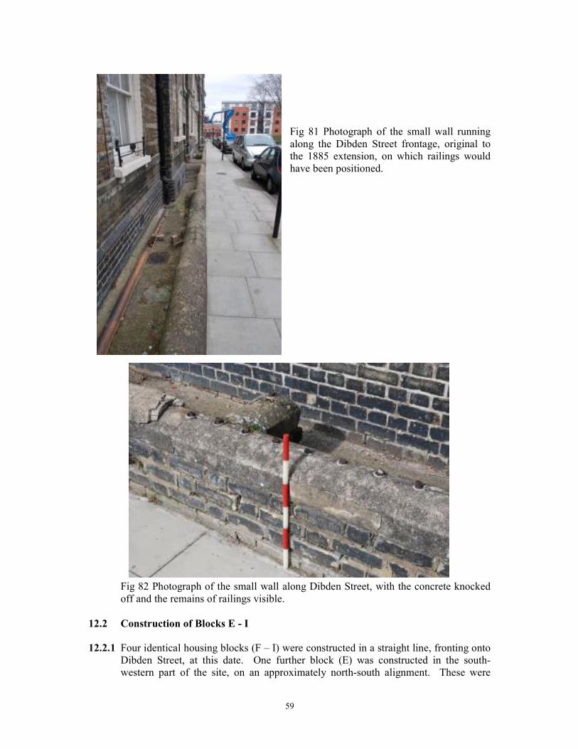
59
Fig 81 Photograph of the small wall running
along the Dibden Street frontage, original to
the 1885 extension, on which railings would
have been positioned.
Fig 82 Photograph of the small wall along Dibden Street, with the concrete knocked
off and the remains of railings visible.
12.2 Construction of Blocks E - I
12.2.1 Four identical housing blocks (F – I) were constructed in a straight line, fronting onto
Dibden Street, at this date. One further block (E) was constructed in the south-
western part of the site, on an approximately north-south alignment. These were
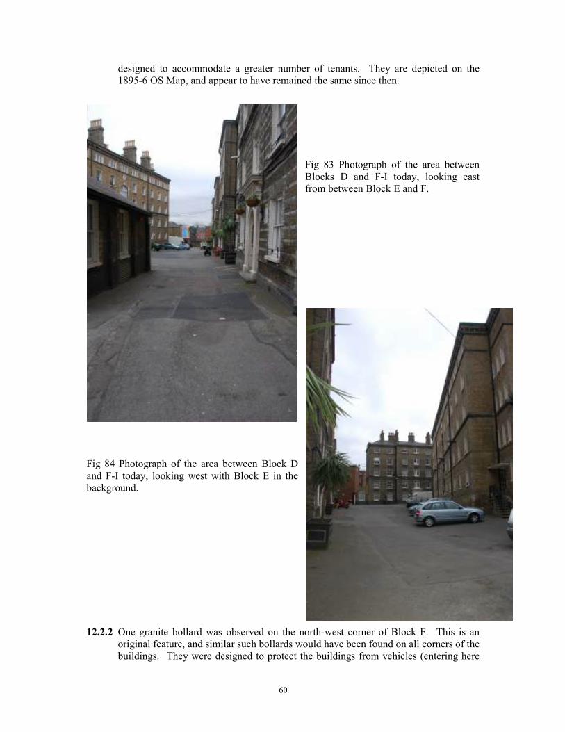
60
designed to accommodate a greater number of tenants. They are depicted on the
1895-6 OS Map, and appear to have remained the same since then.
Fig 83 Photograph of the area between
Blocks D and F-I today, looking east
from between Block E and F.
Fig 84 Photograph of the area between Block D
and F-I today, looking west with Block E in the
background.
12.2.2 One granite bollard was observed on the north-west corner of Block F. This is an
original feature, and similar such bollards would have been found on all corners of the
buildings. They were designed to protect the buildings from vehicles (entering here
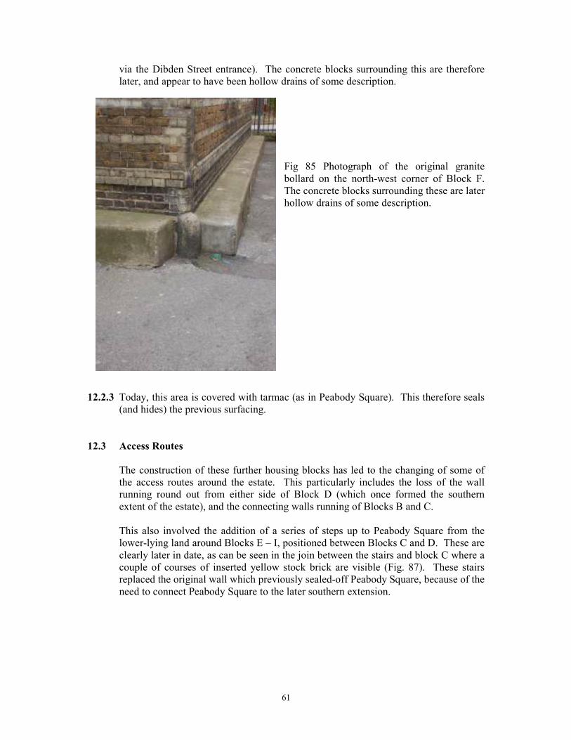
61
via the Dibden Street entrance). The concrete blocks surrounding this are therefore
later, and appear to have been hollow drains of some description.
Fig 85 Photograph of the original granite
bollard on the north-west corner of Block F.
The concrete blocks surrounding these are later
hollow drains of some description.
12.2.3 Today, this area is covered with tarmac (as in Peabody Square). This therefore seals
(and hides) the previous surfacing.
12.3 Access Routes
The construction of these further housing blocks has led to the changing of some of
the access routes around the estate. This particularly includes the loss of the wall
running round out from either side of Block D (which once formed the southern
extent of the estate), and the connecting walls running of Blocks B and C.
This also involved the addition of a series of steps up to Peabody Square from the
lower-lying land around Blocks E – I, positioned between Blocks C and D. These are
clearly later in date, as can be seen in the join between the stairs and block C where a
couple of courses of inserted yellow stock brick are visible (Fig. 87). These stairs
replaced the original wall which previously sealed-off Peabody Square, because of the
need to connect Peabody Square to the later southern extension.
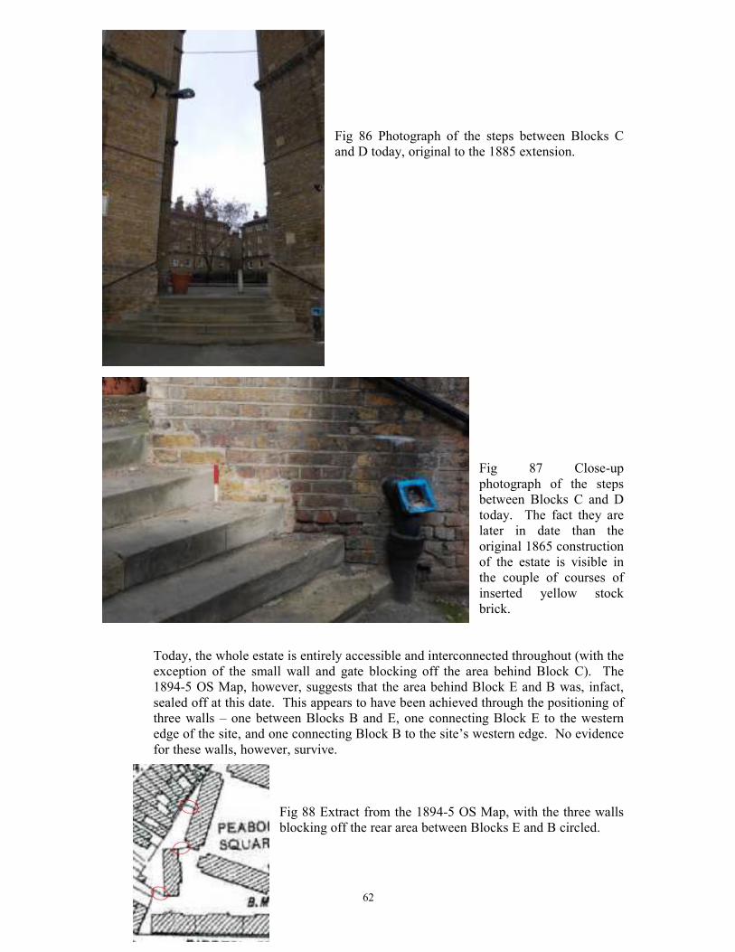
62
Fig 86 Photograph of the steps between Blocks C
and D today, original to the 1885 extension.
Fig 87 Close-up
photograph of the steps
between Blocks C and D
today. The fact they are
later in date than the
original 1865 construction
of the estate is visible in
the couple of courses of
inserted yellow stock
brick.
Today, the whole estate is entirely accessible and interconnected throughout (with the
exception of the small wall and gate blocking off the area behind Block C). The
1894-5 OS Map, however, suggests that the area behind Block E and B was, infact,
sealed off at this date. This appears to have been achieved through the positioning of
three walls – one between Blocks B and E, one connecting Block E to the western
edge of the site, and one connecting Block B to the site’s western edge. No evidence
for these walls, however, survive.
Fig 88 Extract from the 1894-5 OS Map, with the three walls
blocking off the rear area between Blocks E and B circled.
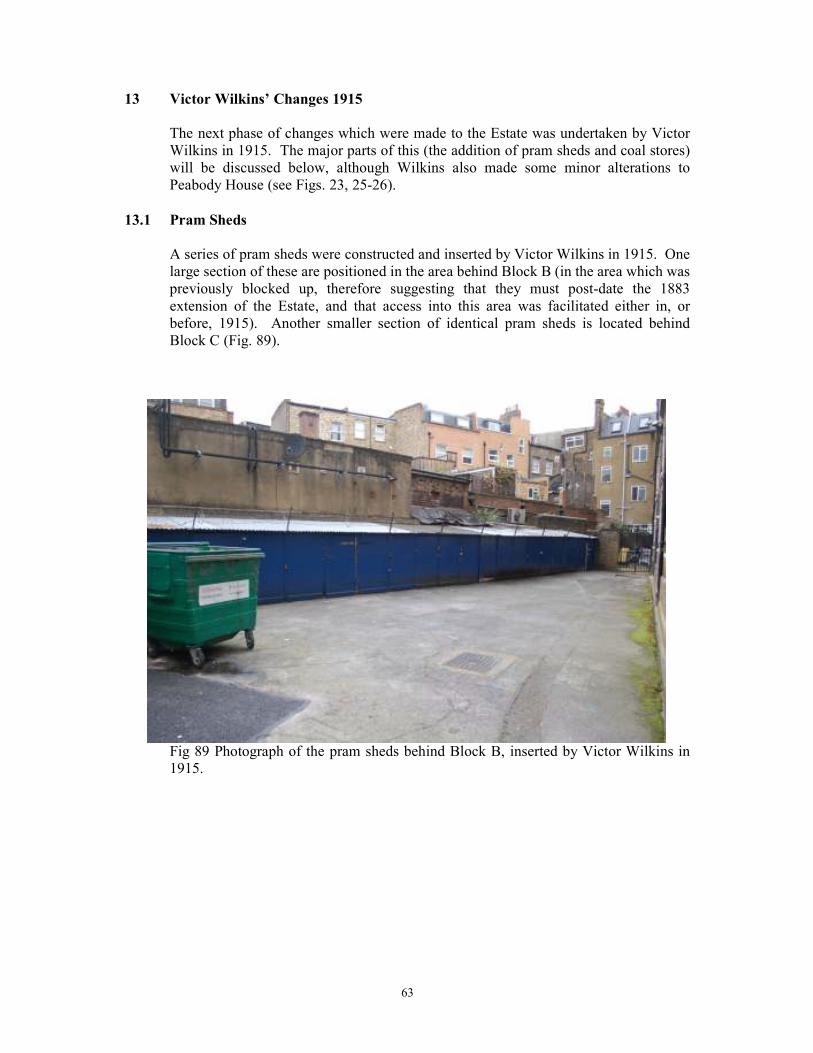
63
13 Victor Wilkins’ Changes 1915
The next phase of changes which were made to the Estate was undertaken by Victor
Wilkins in 1915. The major parts of this (the addition of pram sheds and coal stores)
will be discussed below, although Wilkins also made some minor alterations to
Peabody House (see Figs. 23, 25-26).
13.1 Pram Sheds
A series of pram sheds were constructed and inserted by Victor Wilkins in 1915. One
large section of these are positioned in the area behind Block B (in the area which was
previously blocked up, therefore suggesting that they must post-date the 1883
extension of the Estate, and that access into this area was facilitated either in, or
before, 1915). Another smaller section of identical pram sheds is located behind
Block C (Fig. 89).
Fig 89 Photograph of the pram sheds behind Block B, inserted by Victor Wilkins in
1915.
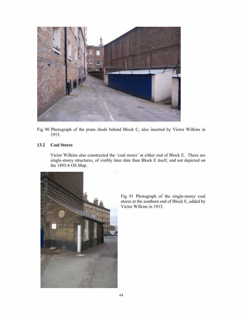
64
Fig 90 Photograph of the pram sheds behind Block C, also inserted by Victor Wilkins in
1915.
13.2 Coal Stores
Victor Wilkins also constructed the ‘coal stores’ at either end of Block E. These are
single-storey structures, of visibly later date than Block E itself, and not depicted on
the 1895-6 OS Map.
Fig 91 Photograph of the single-storey coal
stores at the southern end of Block E, added by
Victor Wilkins in 1915.
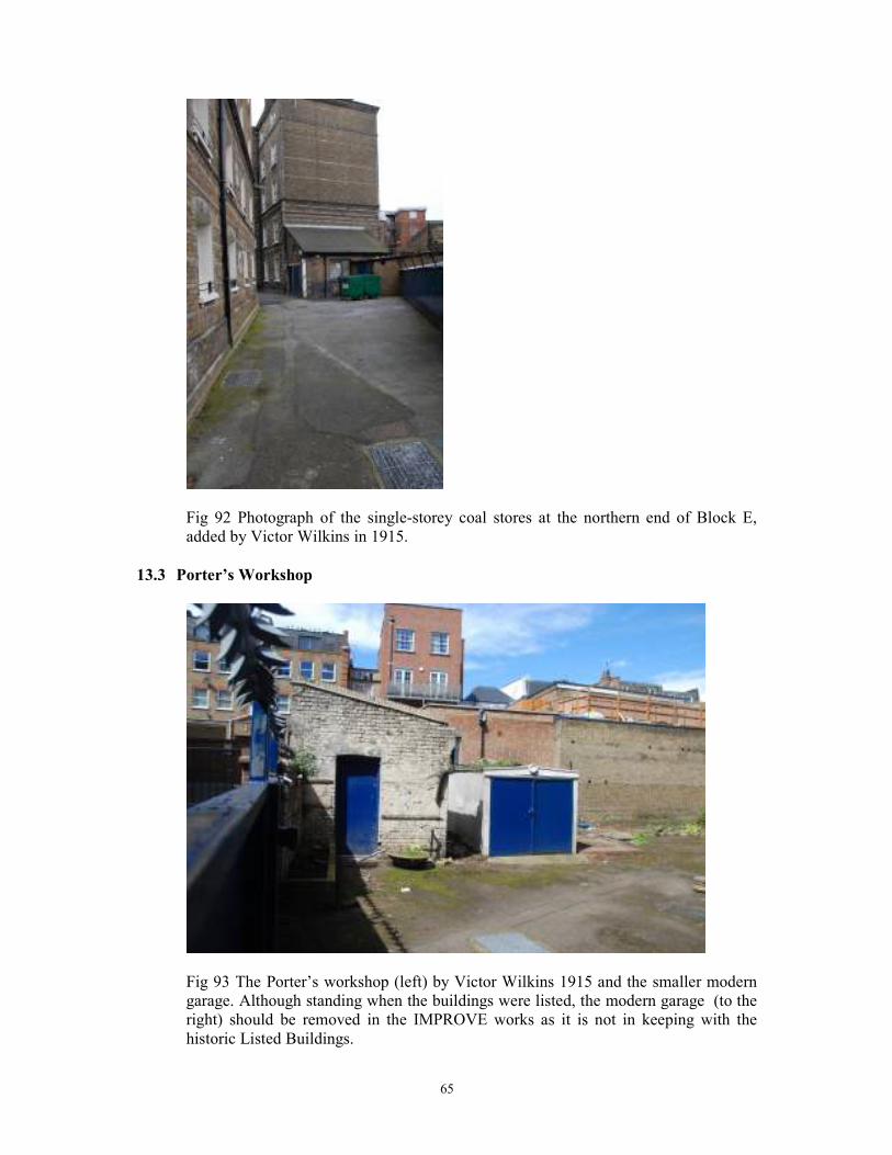
65
Fig 92 Photograph of the single-storey coal stores at the northern end of Block E,
added by Victor Wilkins in 1915.
13.3 Porter’s Workshop
Fig 93 The Porter’s workshop (left) by Victor Wilkins 1915 and the smaller modern
garage. Although standing when the buildings were listed, the modern garage (to the
right) should be removed in the IMPROVE works as it is not in keeping with the
historic Listed Buildings.
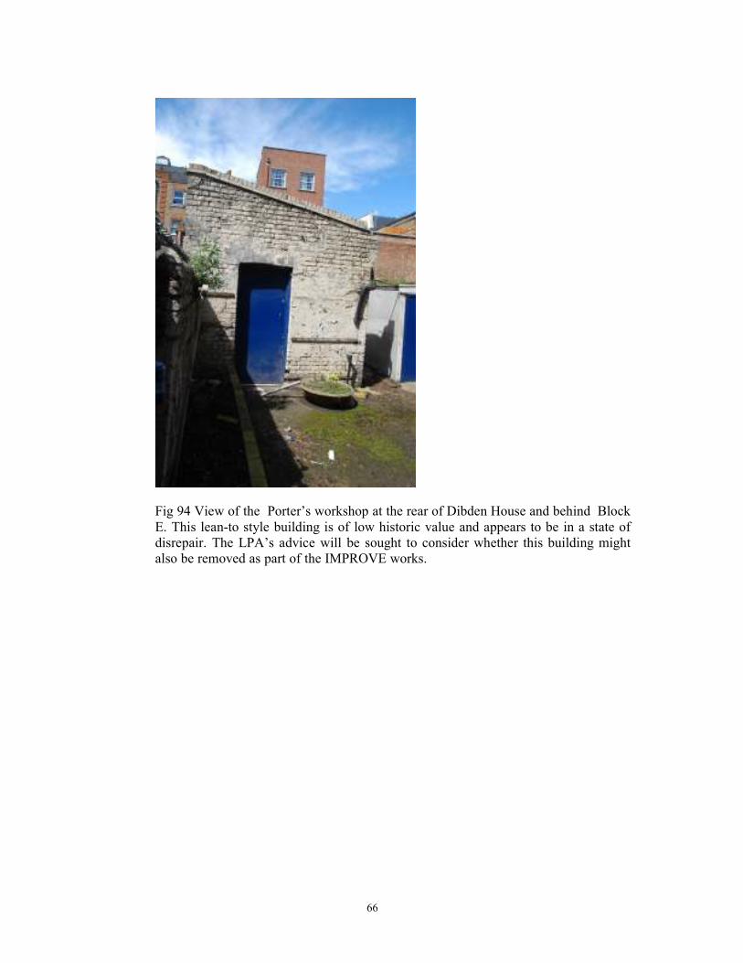
66
Fig 94 View of the Porter’s workshop at the rear of Dibden House and behind Block
E. This lean-to style building is of low historic value and appears to be in a state of
disrepair. The LPA’s advice will be sought to consider whether this building might
also be removed as part of the IMPROVE works.
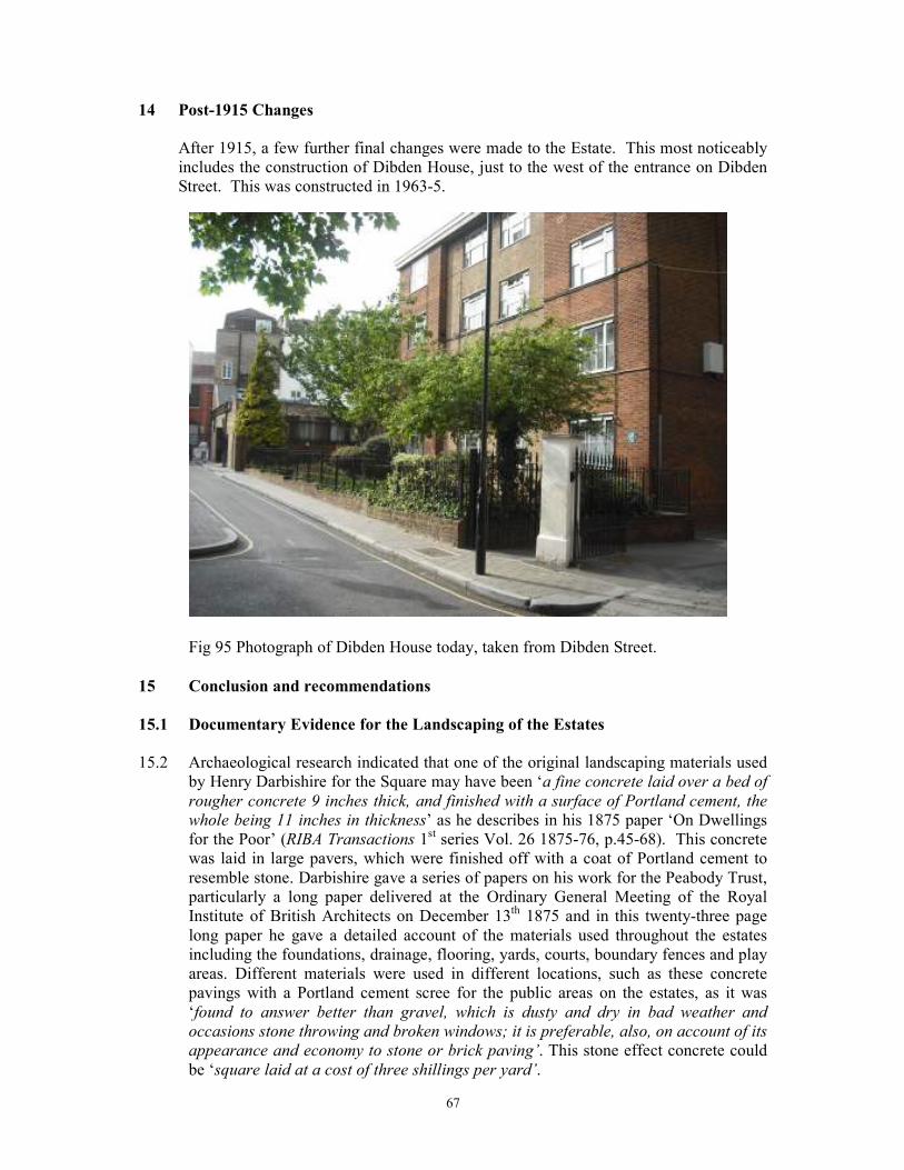
67
14 Post-1915 Changes
After 1915, a few further final changes were made to the Estate. This most noticeably
includes the construction of Dibden House, just to the west of the entrance on Dibden
Street. This was constructed in 1963-5.
Fig 95 Photograph of Dibden House today, taken from Dibden Street.
15 Conclusion and recommendations
15.1 Documentary Evidence for the Landscaping of the Estates
15.2 Archaeological research indicated that one of the original landscaping materials used
by Henry Darbishire for the Square may have been ‘a fine concrete laid over a bed of
rougher concrete 9 inches thick, and finished with a surface of Portland cement, the
whole being 11 inches in thickness’ as he describes in his 1875 paper ‘On Dwellings
for the Poor’ (RIBA Transactions 1st series Vol. 26 1875-76, p.45-68). This concrete
was laid in large pavers, which were finished off with a coat of Portland cement to
resemble stone. Darbishire gave a series of papers on his work for the Peabody Trust,
particularly a long paper delivered at the Ordinary General Meeting of the Royal
Institute of British Architects on December 13th 1875 and in this twenty-three page
long paper he gave a detailed account of the materials used throughout the estates
including the foundations, drainage, flooring, yards, courts, boundary fences and play
areas. Different materials were used in different locations, such as these concrete
pavings with a Portland cement scree for the public areas on the estates, as it was
‘found to answer better than gravel, which is dusty and dry in bad weather and
occasions stone throwing and broken windows; it is preferable, also, on account of its
appearance and economy to stone or brick paving’. This stone effect concrete could
be ‘square laid at a cost of three shillings per yard’.
68
Despite this data it is apparent from the six test pits that Darbishire did not choose to
use this method for the Islington estate and there is no physical evidence of this
deposit on the site.
15.3 Another material which Darbishire documents as using on the Peabody estates in
‘open spaces or courts which surround the buildings’ was ‘Hobman’s tar-paving, laid
upon a bed of rough concrete, and finished with a fine surface resembling asphalt’.
The Hobman’s tar-paving was also mentioned by Darbishire in an article he produced
for The Builder dated February 9th 1884 entitled ‘Artisans’ and Labourers’ Dwellings:
the Buildings of the Peabody Trust’, this article was based on a paper presented at the
Parkes Museum on 31st January 1983. With regard to the open spaces and play areas,
Darbishire made the general observation in 1875 that:
‘If the health and recreation of the tenants are to be considered, and the dwellings are
to have play grounds in addition to their other attractions, these spaces require
careful attention. They must be made cheerful, but not ornamental, with plants or
shrubs, which need constant care, and they must be covered with some durable
surface, which shall neither look prison-like nor enable children to destroy it without
difficulty. In limited spaces stone, tile or brick pavements will answer well, but in
large spaces these become too expensive, and as gravel has many objections, the
covering which is found to answer best is the concrete already described (Darbishire
1875, p.45-6).’
15.4. Hobman’s tar paving was a bed of rough concrete finished with a fine surface
resembling asphalt. It is possible that once Darbishire realised that the gravel was
dusty and anti-social and was failing at the early estates, he had the estate tar paved. It
is possible that the black tar deposits in the majority of the test pits are either the
broken up remnants of the tar surfaces or possibly are the actual surface deposits.
15.5 Records in the Peabody Archive note that all the Peabody Squares were ‘tar-paved’
by 1912, and many asphalted by 1919. There is also evidence from two reports:
‘Report on the Peabody Donation Fund: General Information Regarding the Peabody
Buildings’ (Revised 1912) and ‘Report on the Peabody Donation Fund Estates’
(1919). These reports also note that ‘granolithic paving’ was introduced into the older
squares, where the drainage layout was suitable by 1912.
15.6 Prior to the discovery of these papers by Darbishire in the RIBA archive it was felt
that the Square was most probably paved in York Stone, with gravel paths. This was
based upon plans created by Peabody’s own architect, Victor Wilkins, who
resurveyed the site in the 1930s (cf. Figs 23 and 25-26). However, it does seem from
the documentary evidence and from the results of the test pit investigation that
although York stone was used in some locations such as Peabody Yard, it was not
used in the main square, apart from the York stone curving kerb line. It is likely that
the Square was initially covered with gravel, separated by the York stone kerb and
then later by an external tar covering on the roadway area on a bed of rough concreted
gravel, and later by a tar covering on the interior and granolithic paving on the
exterior of the kerb. The orange/yellow gravel would have mirrored and complemented
the yellow brickwork of the blocks, giving a pleasing aspect to the Square.
69
15.7 It appears that this tar surface was laid after the gravel was found to be unsuitable and
the narrow flush York stone kerb was retained to break up the area and emphasise the
symmetry
15.8 Darbishire notes that with regard to surfaces, fences or railings:
‘These, like the site and drainage, are subject to great variation. ….. No uniform rule
can be laid down as to what will be suitable, economical or desirable in every case,
and as the material of the fences varies, so also will their cost1’.
Therefore, it is evident that the materials used were very much predicated by the
social setting of the estate and by economy. It would appear from the surviving low
lying wall bases, with buttresses for the railing traces, along Dibden Street and in
other locations that the estate was surrounded with iron railings. Few elements of
these original railings now survive, either in Peabody Yard or around the site
entrances. In the case of the Superintendent’s House, Peabody House, later survey
drawings survive from 1936, 1964 and 1983 and show a landscape of stone flag
pavers and granite sett pavers. Original cobbles survive in Peabody Yard, behind
Peabody House. York stone flags are evident in the blocked entranceway from
Greenman Street adjacent to Peabody Yard. As noted above the only architects’
drawings that survive are drawings by Peabody’s own in-house architect Victor
Wilkins, with surveys surviving from the 1930s and later (Christine Wagg, pers
comm).
This report details the results of documentary research, a thorough walk-over survey
of the site, and on-site intrusive investigations under the tarmac. This was undertaken
as a way of gaining a greater understanding of the original landscaping materials,
street furniture, and associated surfaces and features on the Islington estate, with the
aim of incorporating historically appropriate designs into the IMPROVE works.
The report has noted the survival of some heritage features dating to the first
construction of the Islington estate by Darbishire in 1865. This includes, most
notably, the general layout of the Square and western entrance from Greenman Street,
and Peabody Yard and House (with the original cobbled surface). The curving arc of
the wall between Blocks C and D recorded in Test Pit 1. Remains of the original kerb
around the Square was also noted (although largely hidden under the tarmac), and a
small section of walling at the western entrance from Greenman Street. Other
heritage features do not, however, survive to date. This includes the eastern entrance
from Greenman Street, which is now blocked off and completely remodelled; and the
actual gates, railings, and layout of the western entrance. It is possible that the eastern
entrance from Greenman Street, with the stairs, could be re-instated to recapture some
of the original layout and feel of the estate. Later revisions to the estate were also
recorded such as the linear concrete gulleys running adjacent to the housing blocks,
and some of the serpentine gulleys at the end of the housing blocks. The original
surfacing of the estate is currently covered with tarmac, and overlies granolithic
paving on the roadway areas (thought to have been inserted in the early 20th century),
and evidence from the test pit investigation shows that the earliest surface was gravel,
possibly with the York stone kerb standing on a concreted gravel base, then
1 Ibid, p56
70
resurfaced in a tar and concrete deposits and finally a later re-surfacing with
granolithic pavers.
Some heritage features associated with the 1885 extension of the Estate were also
noted. This includes the layout of the Dibden Street entrance and the gate piers here
(although not the gate itself), the small wall running along Dibden Street with the
remnants of railings which were once positioned on top of this, a single granite
bollard on the north-west corner of Block F, and the steps between Blocks C and D.
A couple of other features were noted during the report associated with later changes
made to the Estate. This includes, most noticeably, the pram sheds, coal stores and
Porter’s workshop added by Victor Wilkins in 1915.
It is hoped that some of these heritage features will be retained in the IMPROVE
works, and that the information provided in this report will help ascertain if any other
features (including the original surfacing of the estate) can be re-instated, thereby in
keeping with the historic nature of the Estate and its Listed status. If a suitable modern
surfacing that appeared to be like the yellow/orange gravel could be found for the
interior area of the Square, with the limestone kerb and granolithic slab paving for the
roadway area, this would provide a surfacing similar to that envisaged by Darbishire
in 1865 and in keeping with the state of the Estate during its heyday in the later part of
the 19th century.
16 Sources consulted
16.1 General sources
Greater London Sites and Monuments Record
Islington Local History Centre
London Metropolitan Archive
RIBA British Architectural Library
Victoria and Albert Museum
16.2 Specific Bibliography
Barker, F. and Jackson, P. 1990 The History of London in Maps.
Baker, T F T (ed) The Victoria history of the county of Middlesex. - Vol. 8: Islington
and Stoke Newington. Institute of Historical Research/Oxford University Press, 1985.
Barson, S. and O’Rourke, M. 2001 ‘The Peabody estates. Conservation Guidelines’
Barton, N. J 1982 The Lost Rivers of London
Cosh, M. 2005 An history of Islington. Historical Publications.
Cosh, M. 1981 An historical walk through Barnsbury. Islington Archaeology and
History Society
Cosh, M. 1993 The squares of Islington 2: Islington Parish. Islington Archaeology
and History Society.
Coull, T. 1861 History and traditions of Islington.
71
Darbishire, H.A, 1875, ‘On dwellings for the Poor’ in RIBA Transactions 1st series
Vol. 26 1875-76.
Darbishire, H.A, 1884, ‘Artisans’ and Labourers’ Dwellings: the Buildings of the
Peabody Trust’ in The Builder 9th February 1884.
Dixon, R and Muthesius, S. 1978 ‘Victorian Architecture
Giles Quarme and Associates, 2012, Heritage Statement in support of the planning
and listed building applications for the alteration of the existing building known as
Peabody House, Greenman Street, Islington.
Harris, C. 1974 Islington.
Hart, V. & Withey, D. 1995 Islington.
IFA 1996 Standard and Guidance for Archaeological Desk-based Assessments
Land Use Consultants, May 2011, Islington estate IMPROVE Project Feasibility
Study.
Mingard, W Vere 1915 The story of Islington and Finsbury.
Nelson, J.1980 The history of Islington: the history, topography and antiquities of the
parish of St Mary Islington in the County of Middlesex.
Peabody Donation Fund, 1912, General Information Regarding the Peabody
Buildings.
Peabody Donation Fund, 1919, Report on the Peabody Donation Fund Estates.
Richardson, J. 2000 Islington past.
Richardson, R. 2000, The Annals of London
Roberts, S. 1975 The story of Islington.
Sainders, A (ed) 2005 The LCC Bomb Damage Maps 1939-1945 The London
Topographical Society
Shields, P. 2000 Essential Islington.
Shields, P. 2000 Islington: the first 2000 years.
Smith, G. 1995 Islington.
Smith, G. 2002 Islington: the second selection.
Tarn, J.N. 1971 ‘Working-class Housing in 19th –century Britain’, Architectural
Association Paper Number 7
Tarn, J.N. 1973 ‘Five Per Cent Philanthropy: an Account of housing in urban areas
between 1840 and 1914’, Cambridge University Press
Thompson, A., Westman, A. and Dyson, T. (eds) Archaeology in Greater London
1965-1990. The Archaeological Gazetteer Series, Volume 2 1998
Thorne, J 1876 Environs of London
Victoria County History of Middlesex Vol. VIII: Islington and Stoke Newington
parishes. Oxford
Willats, E. 1987 Streets with a story: the book of Islington. Islington Local History
Education Trust, 1987.
VCH 1912 Victoria History of the Counties of England. (Repr.from the original
1967) Malden, H E (ed)
Zwart, P. 1973 Islington: a history and guide.
Weinreb B, & Hibbert C, 1993 The London Encyclopaedia

72