Embed Size (px)
Citation preview


Peat Coal Seam Gas Water Management Plan MANAGEMENT PLAN
Doc Ref: Q-8100-15-RP-0002 Revision: 4 Page 2 of 74
Australia Pacific LNG Upstream Phase 1
Uncontrolled when printed unless issued and stamped Controlled Copy.
Release Notice
This document is available through the Australia Pacific LNG Upstream Phase 1 Project controlled
document system TeamBinder™. The responsibility for ensuring that printed copies remain valid rests with
the user. Once printed, this is an uncontrolled document unless issued and stamped Controlled Copy.
Third-party issue can be requested via the Australia Pacific LNG Upstream Phase 1 Project Document
Control Group.
Document Conventions
The following terms in this document apply:
Will, shall or must indicate a mandatory course of action
Should indicates a recommended course of action
May or can indicate a possible course of action.
Document Custodian
The custodian of this document is the Australia Pacific LNG Upstream Phase 1 Project – Water Solutions
Development Manager. The custodian is responsible for maintaining and controlling changes (additions
and modifications) to this document and ensuring the stakeholders validate any changes made to this
document.
Deviations from Document
Any deviation from this document must be approved by the Australia Pacific LNG Upstream Phase 1
Project – Water Solutions Development Manager.

Peat Coal Seam Gas Water Management Plan MANAGEMENT PLAN
Doc Ref: Q-8100-15-RP-0002 Revision: 4 Page 3 of 74
Australia Pacific LNG Upstream Phase 1
Uncontrolled when printed unless issued and stamped Controlled Copy.
Executive Summary This coal seam gas (CSG) water management plan (CWMP) describes how water produced from CSG wells
in the Peat development area (petroleum lease 101) is managed safely and in a manner that is consistent
with the Queensland Government’s CSG Water Management Policy (DEHP 2012a), ensuring the protection
of environmental values (EVs) whilst balancing social and economic factors. It has been prepared to meet
Condition (D1), (D2), (D8) and (D9) of environmental authority EPPG00653413 (the Peat EA) and to
support an application to amend Condition (D3) and to add a new Condition (D16) as follows:
Existing Condition (D3):
The holder of this authority must ensure that any ponds used as a primary means of disposal of
associated water are decommissioned, remediated and the area rehabilitated to final land use
standard by 1 November 2011.
Proposed Amended Condition (D3):
Subject to Condition (D16), the holder of this authority must ensure that any ponds used as a primary
means of disposal of associated water are decommissioned by 1 November 2011.
Proposed New Condition (D16):
Despite Condition (D3) of this environmental authority, Peat GPF Pond 2 may be used as a primary
means of disposal of associated water.
The Peat development area covers approximately 24,000 ha of land in the Surat Basin of south central
Queensland between the towns of Wandoan, Taroom and Miles. Land use is dominated by grazing of
natural vegetation and local hydrology comprises ephemeral streams of the Dawson River sub-catchment.
CSG production in the Peat development area commenced in late 2000. The current rate of CSG water
production is low (around 0.02 ML/d) and, with no approved plans to expand CSG operations, is expected
to gradually decline over time. CSG water is currently gathered via buried pipelines to one (1) of five (5)
CSG water storage ponds; Gas Processing Facility (GPF) Pond 1, GPF Pond 2, Pond 12 Cell 1 and Cell 2,
and Pond 32. Where appropriate, and in accordance with the Peat EA, stored CSG water is used for
construction and dust suppression. The stored volume of water is also reduced by natural evaporation.
Development of a revised CSG water management strategy for the Peat development area addresses the
aforementioned conditions of the Peat EA and accounts for the field-specific characteristics of CSG water
production. A local needs analysis and performance evaluation of alternative CSG water management
options is presented in Table E-1.
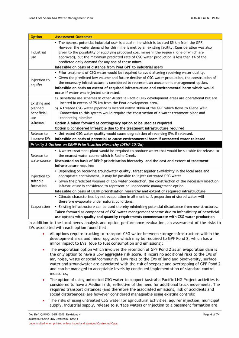
Table E-1: Local Needs Analysis and Option Performance Evaluation
Option Assessment Outcomes
Priority 1 Options on DEHP Prioritisation Hierarchy (DEHP 2012a)
Municipal
water
supply
The predicted annual maximum CSG water production in the Peat development area equates to 2%
of the annual water requirements of Taroom, Wandoan or Miles.
CSG water would require treatment prior to supply, necessitating complex infrastructure with a
prohibitively high cost for supply for municipal use.
Infeasible on basis of inability to meet demand and extent of required infrastructure
Agricultural
use
There is only a very small area (15 ha) of irrigation within the development area, and it is located
23 km south of the Peat GPF.
There are four (4) feedlots within 15 km of the Peat GPF however CSG water production rates
could only be sufficient to meet the demand from one (1) of these feedlots and only for a limited
period (given that water production rates will decline over time).
Consultation with local landholders indicates they are unwilling to accept the predicted volumes
and qualities of CSG water available.
Infeasible on basis of inability to support long-term scheme, extent of required infrastructure
and lack of demand for available water quantity and quality from local landholders
Project
activities
CSG water could meet demand for dust suppression and construction in the development area.
Untreated CSG water could be used, subject to meeting water quality limits in Peat EA.
Taken forward due to potential of CSG water production to meet volume and quality demands
Peat Coal Seam Gas Water Management Plan MANAGEMENT PLAN
Doc Ref: Q-8100-15-RP-0002 Revision: 4 Page 4 of 74
Australia Pacific LNG Upstream Phase 1
Uncontrolled when printed unless issued and stamped Controlled Copy.
Option Assessment Outcomes
Industrial
use
The nearest potential industrial user is a coal mine which is located 85 km from the GPF.
However the water demand for this mine is met by an existing facility. Consideration was also
given to the possibility of supplying proposed coal mines in the region (none of which are
approved), but the maximum predicted rate of CSG water production is less than 1% of the
predicted daily demand for any one of these mines.
Infeasible on basis of distance from Peat GPF to industrial users
Injection to
aquifer
Prior treatment of CSG water would be required to avoid altering receiving water quality.
Given the predicted low volume and future decline of CSG water production, the construction of
the necessary infrastructure is considered to represent an uneconomic management option.
Infeasible on basis on extent of required infrastructure and environmental harm which would
occur if water was injected untreated.
Existing and
planned
beneficial
use
schemes
a) Beneficial use schemes in other Australia Pacific LNG development areas are operational but are
located in excess of 75 km from the Peat development area.
b) A treated CSG water pipeline is located within 10km of the GPF which flows to Glebe Weir.
Connection to this system would require the construction of a water treatment plant and
connecting pipeline
Option A taken forward as contingency option to be used as required
Option B considered infeasible due to the treatment infrastructure required
Release to
improve EVs
Untreated CSG water quality would cause degradation of receiving EVs if released.
Infeasible on basis of potential to cause environmental harm if untreated water released
Priority 2 Options on DEHP Prioritisation Hierarchy (DEHP 2012a)
Release to
watercourse
A water treatment plant would be required to produce water that would be suitable for release to
the nearest water course which is Roche Creek.
Discounted on basis of DEHP prioritisation hierarchy and the cost and extent of treatment
infrastructure required
Injection to
suitable
formation
Depending on receiving groundwater quality, target aquifer availability in the local area and
appropriate containment, it may be possible to inject untreated CSG water.
Given the predicted volumes of CSG water production, the construction of the necessary injection
infrastructure is considered to represent an uneconomic management option.
Infeasible on basis of DEHP prioritisation hierarchy and extent of required infrastructure
Evaporation
Climate characterised by net evaporation in all months. A proportion of stored water will
therefore evaporate under natural conditions.
Existing infrastructure can be used thereby minimising potential disturbance from new structures.
Taken forward as component of CSG water management scheme due to infeasibility of beneficial
use options with quality and quantity requirements commensurate with CSG water production
In addition to the local needs analysis and option performance evaluation, an assessment of the risks to
EVs associated with each option found that:
All options require trucking to transport CSG water between storage infrastructure within the
development area and minor upgrades which may be required to GPF Pond 2, which has a
minor impact to EVs (due to fuel consumption and emissions);
The evaporation option which involves the retention of GPF Pond 2 as an evaporation dam is
the only option to have a Low aggregate risk score. It incurs no additional risks to the EVs of
air, noise, waste or social/community. Low risks to the EVs of land and biodiversity, surface
water and groundwater are associated with the risk of seepage and overtopping of GPF Pond 2
and can be managed to acceptable levels by continued implementation of standard control
measures;
The option of using untreated CSG water to support Australia Pacific LNG Project activities is
considered to have a Medium risk, reflective of the need for additional truck movements. The
required transport distances (and therefore the associated emissions, risk of accidents and
social disturbances) are however considered manageable using existing controls;
The risks of using untreated CSG water for agricultural activities, aquifer injection, municipal
supply, industrial supply, release to surface waters or injection to a basement formation are

Peat Coal Seam Gas Water Management Plan MANAGEMENT PLAN
Doc Ref: Q-8100-15-RP-0002 Revision: 4 Page 5 of 74
Australia Pacific LNG Upstream Phase 1
Uncontrolled when printed unless issued and stamped Controlled Copy.
considered High or Severe and unacceptable reflecting the unsuitable nature of CSG water
quality as compared to relevant guideline criteria and a lack of suitable demand; and
The risks associated with all options that involve long-term treatment of CSG water by
Australia Pacific LNG are considered High and unacceptable, reflecting the need for regular
long-term truck movements to transport the water, either to the WTF or to a beneficial use
scheme, as well as land disturbance associated with installation of infrastructure.
On the basis of the assessments documented in this CWMP, the revised CSG water management strategy
for the Peat development area is as follows:
Aggregation of CSG water to a single, lined CSG water storage pond (GPF Pond 2);
Local beneficial use of stored CSG water to support construction and dust suppression;
Natural evaporation reflecting the regional climate; and
If required to manage unexpected CSG water production or extreme weather events that
cause the maximum operating level of storage infrastructure to be approached (as defined in
the structure’s operational plan), short-term trucking of CSG water for beneficial use in
another Australia Pacific LNG development area.
To transition the existing scheme to one which supports the revised CSG water management strategy,
Australia Pacific LNG will conduct the following activities:
Closed tank(s) will be installed at the site of Pond 12. Pond 12 and Pond 32 will be
decommissioned. The existing high density polyethylene (HDPE) pipelines connecting CSG
wells to this pond will be disconnected from the pond and reconnected to the closed tank(s).
CSG water previously gathered to Pond 32 will be gathered by the existing pipeline network to
the closed tank(s) at the site of Pond 12. GPF Pond 1 will be decommissioned and the HDPE
pipeline connected to GPF Pond 2;
Pond 12 Cell 1 and Cell 2, Pond 32 and GPF Pond 1 will be decommissioned and remediated in
accordance with a Transitional Environmental Program to be submitted to DEHP in 2015;
Regular vehicle movements will be established to truck CSG water from the closed tank(s) to
GPF Pond 2. The road on public land linking Pond 12 to the sealed public road will be
upgraded to allow for regular truck access;
The proposed CSG water management strategy is aligned to the CSG Water Management Policy (DEHP
2012a) and addresses the conditions of the Peat EA (amended as proposed) by:
Decommissioning and remediating four (4) of the five (5) existing CSG water storage ponds;
Prioritising feasible beneficial use in the vicinity of extraction for dust suppression and
construction activities in accordance with the relevant approval;
Utilising natural evaporation to manage produced water volumes that cannot be feasibly
beneficially used; and
In the event that unexpected weather or unforseen CSG water production lead to a
substantial increase in water levels within GPF Pond 2, excess water will be trucked to
another Australia Pacific LNG development area for beneficial use.
Scheme performance will be assessed via monitoring against a set of measurable criteria. If it is found
that a criterion has not been met, causes will be investigated and, where required to protect EVs,
changes to the scheme made. All incidents will be managed in accordance with the LNG Environmental
Incident Procedure (OEUP-Q1000-PRO-ENV-006).
Australia Pacific LNG is committed to regularly reviewing the Peat CWMP in order to establish whether
new or optimised CSG water management options are required and if so, whether or not they are
feasible.

Peat Coal Seam Gas Water Management Plan MANAGEMENT PLAN
Doc Ref: Q-8100-15-RP-0002 Revision: 4 Page 6 of 74
Australia Pacific LNG Upstream Phase 1
Uncontrolled when printed unless issued and stamped Controlled Copy.
Table of Contents EXECUTIVE SUMMARY ............................................................................................................................................. 3
TERMS, ABBREVIATIONS AND DEFINITIONS ........................................................................................................... 10
ORIGIN ENERGY DOCUMENT REFERENCES ............................................................................................................. 12
1. INTRODUCTION .............................................................................................................................................. 13
1.1. BACKGROUND .................................................................................................................................................... 13 1.2. OBJECTIVES OF THE CWMP .................................................................................................................................. 13
2. RESOURCE PROFILE......................................................................................................................................... 16
2.1. OVERVIEW OF THE PEAT DEVELOPMENT AREA .......................................................................................................... 16 2.2. EXISTING INFRASTRUCTURE ................................................................................................................................... 16
2.2.1. GPF Ponds ............................................................................................................................................... 17 2.2.2. Pond 12 Cell 1 and Cell 2 ........................................................................................................................ 17 2.2.3. Pond 32 .................................................................................................................................................. 17
2.3. CSG WATER QUANTITY ....................................................................................................................................... 20 2.3.1. Observed CSG Water Production Rates .................................................................................................. 20 2.3.2. Predicted Future CSG Water Production ................................................................................................ 20
2.4. CSG WATER QUALITY .......................................................................................................................................... 21
3. EXISTING ENVIRONMENT ............................................................................................................................... 28
3.1. CLIMATE ............................................................................................................................................................ 28 3.2. LAND ................................................................................................................................................................ 28
3.2.1. Topography and Landscape ................................................................................................................... 28 3.2.2. Geology and Soil ..................................................................................................................................... 29 3.2.3. Land Use ................................................................................................................................................. 29
3.3. GROUNDWATER .................................................................................................................................................. 29 3.4. SURFACE WATER ................................................................................................................................................ 30 3.5. ENVIRONMENTALLY SENSITIVE AREAS AND BIODIVERSITY VALUES ................................................................................. 30
4. ENVIRONMENTAL VALUES AND WATER QUALITY OBJECTIVES ....................................................................... 31
4.1. SUMMARY ......................................................................................................................................................... 31 4.2. ENVIRONMENTAL VALUES OF WATER ...................................................................................................................... 31
5. CSG WATER MANAGEMENT STRATEGY .......................................................................................................... 32
5.1. DRIVERS BEHIND THE STRATEGY ............................................................................................................................. 32 5.1.1. Addressing the Conditions of the Peat EA .............................................................................................. 32 5.1.2. Ensuring Alignment to the CSG Water Management Policy .................................................................. 32 5.1.3. Characteristics of the Peat Development Area ....................................................................................... 33
5.2. APPROACH TO DEVELOPING THE STRATEGY .............................................................................................................. 33 5.2.1. Local Needs Analysis and Option Performance Evaluation .................................................................... 34
5.2.1.1. Municipal Water Supply ...................................................................................................................................... 35 5.2.1.2. Agricultural Use ................................................................................................................................................... 36 5.2.1.3. Industrial Use ....................................................................................................................................................... 41 5.2.1.4. Australia Pacific LNG Project Activities ................................................................................................................ 42 5.2.1.5. Injection ............................................................................................................................................................... 42 5.2.1.6. Existing and Planned Beneficial Use Schemes ..................................................................................................... 42 5.2.1.7. Release in a Manner that Improves Local Environmental Values ........................................................................ 43
5.2.2. Summary of Local Needs Analysis and Performance Evaluation ............................................................ 44 5.2.3. Assessment of Priority 2 Options ............................................................................................................ 44
5.2.3.1. Release to Surface Waters ................................................................................................................................... 45 5.2.3.2. Injection ............................................................................................................................................................... 45

Peat Coal Seam Gas Water Management Plan MANAGEMENT PLAN
Doc Ref: Q-8100-15-RP-0002 Revision: 4 Page 7 of 74
Water Solutions, Australia Pacific LNG Upstream Phase 1
Uncontrolled when printed unless issued and stamped Controlled Copy.
5.2.3.3. Evaporation ......................................................................................................................................................... 45 5.2.4. Assessment of Risks to Environmental Values ........................................................................................ 46 5.2.5. Summary of the CSG Water Management Option Assessment ............................................................. 49
5.3. IMPLEMENTING THE REVISED STRATEGY................................................................................................................... 49
6. CSG WATER MANAGEMENT SCHEME ............................................................................................................. 51
6.1. CSG WATER PRODUCTION & GATHERING ............................................................................................................... 51 6.2. CSG WATER STORAGE ......................................................................................................................................... 51 6.3. CSG WATER USE ................................................................................................................................................ 52 6.4. MANAGEMENT OF SALINE WASTE .......................................................................................................................... 52
7. RISKS, POTENTIAL IMPACTS AND MANAGEMENT ........................................................................................... 53
7.1. RISK ASSESSMENT ............................................................................................................................................... 53 7.2. RESIDUAL RISKS AND ADDITIONAL MITIGATION MEASURES ......................................................................................... 53
7.2.1. Existing CSG Water Management Scheme ............................................................................................. 53 7.2.2. Revised CSG Water Management Scheme ............................................................................................. 53
8. MANAGEMENT CRITERIA ................................................................................................................................ 57
9. MONITORING ................................................................................................................................................. 60
9.1. INTEGRITY OF CSG WATER STORAGE PONDS ............................................................................................................ 60 9.2. GROUNDWATER .................................................................................................................................................. 60 9.3. CSG WATER USE ................................................................................................................................................ 61 9.4. DECOMMISSIONING AND REMEDIATION .................................................................................................................. 61
10. MANAGEMENT SYSTEMS AND RECORDS .................................................................................................... 62
10.1. HEALTH, SAFETY AND ENVIRONMENT MANAGEMENT SYSTEM ................................................................................. 62 10.2. PROJECT DELIVERY PROCESS .............................................................................................................................. 62
10.2.1. Environmental Data Management System ............................................................................................ 62 10.2.2. Exploration and Production Operations Management System .............................................................. 62 10.2.3. Enterprise Asset Management System ................................................................................................... 62 10.2.4. Origin Collective Intelligence System ...................................................................................................... 63 10.2.5. ATLAS Compliance Reporting and Recording System ............................................................................. 63
10.3. RISK REGISTERS .............................................................................................................................................. 63 10.4. ROLES AND RESPONSIBILITIES ............................................................................................................................ 63
11. RESPONSE AND REPORTING ....................................................................................................................... 64
11.1. ROUTINE ....................................................................................................................................................... 64 11.2. NON-ROUTINE ................................................................................................................................................ 64
12. REVIEW AND UPDATE OF THE CSG WATER MANAGEMENT STRATEGY ....................................................... 65
13. REFERENCES ................................................................................................................................................ 66
APPENDIX A - ASSESSMENT OF RISKS TO ENVIRONMENTAL VALUES ..................................................................... 68
APPENDIX B - RESPONSIBILITIES FOR CSG WATER MANAGEMENT ......................................................................... 73

Peat Coal Seam Gas Water Management Plan MANAGEMENT PLAN
Doc Ref: Q-8100-15-RP-0002 Revision: 4 Page 8 of 74
Water Solutions, Australia Pacific LNG Upstream Phase 1
Uncontrolled when printed unless issued and stamped Controlled Copy.
List of Tables
Table 1-1: Proposed Amendments to Peat EA ...................................................................... 13
Table 1-2: Summary Requirements of Legislation, Guidelines and Approval Conditions ................... 14
Table 2-1: Existing CSG Water Storage Ponds ...................................................................... 16
Table 2-2: Observed CSG Water Production ........................................................................ 20
Table 2-3: Predicted Future Annual CSG Water Production...................................................... 21
Table 2-4: CSG Water Quality Sampled at CSG Wells ............................................................. 22
Table 2-5: CSG Water Quality Sampled at Ponds .................................................................. 25
Table 3-1: Land Use in the Peat Development Area ............................................................... 29
Table 3-2: Landholder Bore Assessment ............................................................................. 30
Table 4-1: Summary of Environmental Values ...................................................................... 31
Table 4-2: Summary of Environmental Values of Water .......................................................... 31
Table 5-1: Categories of CSG Water Management Option ........................................................ 34
Table 5-2: Option Selection Criteria ................................................................................. 35
Table 5-3: Municipal Water Entitlements ........................................................................... 35
Table 5-4: Land Use in the Peat Development Area ............................................................... 39
Table 5-5: Existing Cattle Feedlots and Piggeries ................................................................. 39
Table 5-6: Water Quality Limit Levels for Irrigation and Stock Watering ..................................... 40
Table 5-7: Landholder Consultation .................................................................................. 40
Table 5-8: Existing and Proposed Coal Mines ....................................................................... 41
Table 5-9: Australia Pacific LNG Water Treatment Facilities and Associated Beneficial Use Schemes .. 42
Table 5-10: CSG Water Quality in Comparison to ANZECC Guideline Values .................................. 44
Table 6-1: Summary Water Balance for Closed Tanks ............................................................. 51
Table 7-1: Risk Assessment for Existing CSG Water Management Scheme .................................... 54
Table 7-2: Risk Assessment for Revised CSG Water Management Scheme ..................................... 55
Table 8-1: Management Criteria for the Peat Development Area ............................................... 58
Table 9-1: CSG Water Storage Pond Monitoring Requirements .................................................. 60
Table 9-2: Peat EA Water Quality Limits for Dust Suppression and Construction Activities ................ 61

Peat Coal Seam Gas Water Management Plan MANAGEMENT PLAN
Doc Ref: Q-8100-15-RP-0002 Revision: 4 Page 9 of 74
Water Solutions, Australia Pacific LNG Upstream Phase 1
Uncontrolled when printed unless issued and stamped Controlled Copy.
List of Figures
Figure 2-1: Location Plan ............................................................................................... 18
Figure 2-2: Existing Infrastructure .................................................................................... 19
Figure 2-3: Predicted Future CSG Water Production .............................................................. 21
Figure 3-1: Regional Climate .......................................................................................... 28
Figure 5-1: DEHP Hierarchy for CSG Water Management ......................................................... 32
Figure 5-2: Waste and Resource Management Hierarchy ......................................................... 33
Figure 5-3: Land Use, Feedlots and Piggeries ...................................................................... 38
Figure 5-4: Predicted Stored CSG Water Volume in GPF Pond 2 ................................................ 46
Figure 5-5: Australia Pacific LNG Risk Matrix ....................................................................... 47

Peat Coal Seam Gas Water Management Plan MANAGEMENT PLAN
Doc Ref: Q-8100-15-RP-0002 Revision: 4 Page 10 of 74
Water Solutions, Australia Pacific LNG Upstream Phase 1
Uncontrolled when printed unless issued and stamped Controlled Copy.
Terms, Abbreviations and Definitions
Term/Abbreviation Definition
AEP Annual exceedance probability
ANZECC Guideline Australian and New Zealand Guidelines for Fresh and Marine Water Quality (ANZECC
and ARMCANZ 2000)
Australia Pacific LNG Australia Pacific LNG Pty Limited
BoM Australian Government Bureau of Meteorology
BUA Beneficial use approval
CSG Coal seam gas
CSG water Water produced from a CSG well to enable gas production
CWMP CSG Water Management Plan (referred to as an AWM Plan in the Peat EA)
DAFF Queensland Government Department of Agriculture, Fisheries and Forestry
DEHP Queensland Government Department of Environment and Heritage Protection
DNRM Queensland Government Department of Natural Resources and Mines
DSA Design storage allowance
EA Environmental authority
EAMS Enterprise Asset Management System
EP Act Environmental Protection Act 1994 (Qld)
EPOMS Exploration and Production Operations Management System
EPP Water Environmental Protection (Water) Policy 2009 (Qld)
ESA Environmentally sensitive area
EV Environmental value
GAB Great Artesian Basin
General BUA General Beneficial Use Approval
GPF Gas Processing Facility
HDPE High density polyethylene
HSE Health, safety and environment
HSEMS Health, Safety and Environment Management System
LNG Liquefied natural gas
OCIS Origin Collective Intelligence System
Origin Energy Origin Energy Resources Limited
PDP Project delivery process
Peat development area Area encompassing petroleum lease PL101
Peat EA Environmental authority EPPG00653413 (26 February 2014)
PL Petroleum lease
QLUMP Queensland Land Use Mapping Program

Peat Coal Seam Gas Water Management Plan MANAGEMENT PLAN
Doc Ref: Q-8100-15-RP-0002 Revision: 4 Page 11 of 74
Water Solutions, Australia Pacific LNG Upstream Phase 1
Uncontrolled when printed unless issued and stamped Controlled Copy.
Term/Abbreviation Definition
SCL Strategic cropping land
TDS Total dissolved solids
TEP Transitional Environmental Program
TOWL Top operating water level
Treated CSG water Water produced from a CSG well which has undergone treatment prior to end use
Untreated CSG water Water produced from a CSG well which has not undergone treatment prior to end use
WQO Water quality objective
WTF Water treatment facility

Peat Coal Seam Gas Water Management Plan MANAGEMENT PLAN
Doc Ref: Q-8100-15-RP-0002 Revision: 4 Page 12 of 74
Water Solutions, Australia Pacific LNG Upstream Phase 1
Uncontrolled when printed unless issued and stamped Controlled Copy.
Origin Energy Document References
Document Reference
Talinga-Condabri Integrated Coal Seam Gas Water Management Plan Q-1000-15-MP-0016
Combabula Coal Seam Gas Water Management Plan Q-4200-15-MP-1077
Spring Gully Coal Seam Gas Water Management Plan Q-8200-15-MP-0001
Constraints Planning and Field Development Protocol Q-LNG-15-MP-0109
Disturbance Procedure OEUP-Q1000-PRO-ENV-001
Risk Policy ORG-RISK-POL-001
Risk Management Directive ORG-RISK-DVE-001
Dam and Pond Inspection Guide OEUP-INT1000-GDL-ENG-021
Peat Rehabilitation Plan Q-8100-15-MP-005
Peat Produced Water Storage Facility Groundwater Monitoring Plan OEUP-Q8100-PLN-ENV-002
Land Transport Directive ORG-HSE-DVE-001
Fatigue Risk Management Directive ORG-HSE-DVE-043
Environmental Management Plan: The Peat Gas Plant OEUP-Q8100-PLN-ENV-001
Environmental Constraints Assessment - Preparation and Issue Q-LNG01-15-AW-0014
Biosecurity Management Specification OEUP-Q1000-SPF-ENV-005
LNG Environmental Incident Procedure OEUP-Q1000-PRO-ENV-006
Dam and Pond Inspection Guide OEUP-INT1000-GDL-ENG-021
Dam Inspection Schedule A-1000-20-PS-001
Asset Integrity Management Plan for Dams Q1000-PLN-ENG-002
Procedure for Conducting Annual and Comprehensive Dam Inspections A-1000-20-AP-001
Crisis and Emergency Management Directive ORG-HSE-DVE-003
Incident Management Directive ORG-HSE-DVE-006
Emergency Response Plan: Peat Gas Plant and Field OEUP-Q8100-PLN-SAF-002
Peat Coal Seam Gas Water Management Plan MANAGEMENT PLAN
Doc Ref: Q-8100-15-RP-0002 Revision: 4 Page 13 of 74
Water Solutions, Australia Pacific LNG Upstream Phase 1
Uncontrolled when printed unless issued and stamped Controlled Copy.
1. Introduction
1.1. Background
The Peat development area is located between the towns of Wandoan, Taroom and Miles in south central
Queensland and extends across petroleum lease (PL) 101, an area of approximately 24,000 ha. Coal seam
gas (CSG) production in the Peat development area commenced in late 2000, with operations undertaken
by Origin Energy Resources Limited (Origin Energy) on behalf of Australia Pacific LNG Pty Limited
(Australia Pacific LNG).
CSG activities are authorised by environmental authority (EA) EPPG00653413 (the Peat EA), issued by the
Queensland Government Department of Environment and Heritage Protection (DEHP) on 10 March 2015.
The process of producing gas from CSG wells produces water (herein termed CSG water) which will be
managed in accordance with this CSG water management plan (CWMP).
1.2. Objectives of the CWMP
This CWMP has the objective of safely and appropriately managing CSG water in order to protect
environmental values (EVs) whilst balancing social and economic considerations. It describes the
approach to CSG water management by considering the specific characteristics of CSG water production
in the Peat development area as well as local demands for this resource from water users. This CWMP
also supports an application to amend Condition (D3) of the Peat EA and to add a new condition as
outlined in Table 1-1.
Table 1-1: Proposed Amendments to Peat EA
Condition Proposed Amendment
D3
Existing Condition (D3):
The holder of this authority must ensure that any ponds used as a primary means of disposal of
associated water are decommissioned, remediated and the area rehabilitated to final land use
standard by 1 November 2011.
Proposed Amended Condition (D3):
Subject to Condition (D16), the holder of this authority must ensure that any ponds used as a
primary means of disposal of associated water are decommissioned by 1 November 2011.
D16 (New)
Proposed New Condition (D16):
Despite Condition (D3) of this environmental authority, Peat GPF Pond 2 may be used as a primary
means of disposal of associated water.
This CWMP has been prepared in accordance with the following documents:
The Peat EA, specifically Condition (D1) to Condition (D9), and the proposed condition
amendments;
The Environmental Protection Act 1994 (Qld) (the EP Act), specifically Section 126; and
The 2012 CSG Water Management Policy, published by DEHP.
Table 1-2 lists relevant requirements from the Peat EA and EP Act and indicates the section of this CWMP
in which each requirement is met.

Peat Coal Seam Gas Water Management Plan MANAGEMENT PLAN
Doc Ref: Q-8100-15-RP-0002 Revision: 4 Page 14 of 74
Water Solutions, Australia Pacific LNG Upstream Phase 1
Uncontrolled when printed unless issued and stamped Controlled Copy.
Table 1-2: Summary Requirements of Legislation, Guidelines and Approval Conditions
Requirement Section Reference
Conditions of the Peat EA
D1 - The holder of this authority must develop and submit, to the administering authority,
an Associated Water Management Plan (AWM Plan)1 for the proposed petroleum activities.
The AWM Plan must adequately identify and quantify all wastes generated and propose
management options for disposing of or beneficially reusing CSG water. The AWM Plan must
address the following matters:
All sections
Identification of environmental issues and potential impacts Section 7
Control measures for routine operations to minimise likelihood of environmental harm Section 7
Contingency plans and emergency procedures for non-routine situations Section 11
Organisational structure and responsibility Section 10.4
Effective communication Section 10.4
Monitoring of contaminant releases Section 9
Conducting environmental impact assessments Section 7
Staff training Section 10.4
Record keeping Section 11
Periodic review of environmental performance and continual improvement Section 11 & 12
D2 - The AWM Plan must set specific performance goals, identify measures to achieve or
maximise the beneficial reuse of CSG water and minimise the generation or emissions of
potential contaminants to the receiving environment. The Plan should:
Section 8
State the objectives to be achieved and maintained under the Plan Section 8
State how the objectives are to be achieved and a timetable to achieve the objectives
taking into account: Section 6
o Best practice environmental management Section 5
o Current technology Section 5
o Risks of environmental harm being caused Section 5
State appropriate performance indicators at time intervals of no more than 12 months Section 8
Make provisions for monitoring and reporting compliance with this Plan Section 9
State how the AWM Plan will comply with the requirements of the 'Queensland Coal
Seam Gas Water Management Policy', released 31 October 2008 [now DEHP 2012a] Section 5
D3 [reflecting proposed amendment] - Subject to Condition (D16), the holder of this
authority must ensure that any ponds used as a primary means of disposal of associated
water are decommissioned by 1 November 2011.
Section 6
D4 – The holder of this authority must submit the AWM Plan for review to the administering
authority within six (6) months after this authority is issued.
Not applicable for
this revision
D5 - The holder of this authority must amend the AWM Plan to reflect any comments
provided by the Administering Authority.
To be completed
following comments
D6 - The holder of this authority must operate all associated water management facilities
in accordance with the AWM Plan.
Demonstrated via
Annual Return
D7 - The AWM Plan must not be implemented or amended in a way that contravenes any
condition of the authority.
Demonstrated via
Annual Return
1 Note that the Peat EA refers to a CWMP as an Associated Water Management Plan (AWM Plan).

Peat Coal Seam Gas Water Management Plan MANAGEMENT PLAN
Doc Ref: Q-8100-15-RP-0002 Revision: 4 Page 15 of 74
Water Solutions, Australia Pacific LNG Upstream Phase 1
Uncontrolled when printed unless issued and stamped Controlled Copy.
Requirement Section Reference
D8 – The holder of this authority must review the AWM Plan every three (3) years. The
review must consider current strategies, best practice alternatives, advances in new
technology, standards and practices in relation to the management of associated water,
new beneficial use proposals and the management of respective waste streams.
Section 5
D9 - Subject to Condition D8 the holder will need to provide justification why existing
management strategies and standards should be continued. Section 5
D16 [Proposed New Condition] - Despite Condition (D3) of this environmental authority,
Peat GPF Pond 2 may be used as a primary means of disposal of associated water Section 5
Section 126 of the EP Act
The quantity of CSG water the applicant reasonably expects will be generated in
connection with carrying out each relevant activity. Section 2.3
The flow rate at which the applicant reasonably expects water will be generated. Section 2.3
The quality of the water, including changes in the water quality that the applicant
reasonably expects will happen while each relevant activity is carried out. Section 2.4
The proposed management of water including use, treatment, storage or disposal. Section 6
The measurable criteria (the management criteria) against which the applicant will
monitor and assess the effectiveness of water management including:
The quantity and quality of the water used, treated, stored or disposed of;
Protection of environmental values affected by each relevant activity; and
The disposal of waste, including, for example, salt.
Section 8
The action proposed to be taken if any of the management criteria are not complied with,
to ensure the criteria will be able to be satisfied in the future. Section 8
Where the proposed management of water provides for using an evaporation dam in
connection with carrying out a relevant activity, include an evaluation of best practice
environmental management that shows there is no feasible alternative.
Section 5

Peat Coal Seam Gas Water Management Plan MANAGEMENT PLAN
Doc Ref: Q-8100-15-RP-0002 Revision: 4 Page 16 of 74
Water Solutions, Australia Pacific LNG Upstream Phase 1
Uncontrolled when printed unless issued and stamped Controlled Copy.
2. Resource Profile
2.1. Overview of the Peat Development Area
The Peat development area is located 14 km east of Wandoan, 62 km southeast of Taroom and 62 km
north of Miles (see Figure 2-1) within the jurisdictional area of the Western Downs Regional Council in
south central Queensland. The development area lies within the Surat Basin and the target formation for
CSG extraction is the Baralaba Formation. The Dawson River sub-catchment of the Fitzroy Basin extends
across the development area and is characterised by a number of ephemeral streams. Existing land use is
dominated by grazing of natural vegetation with some non-irrigated cropping also present.
2.2. Existing Infrastructure
Existing CSG water management infrastructure in the Peat development area is shown in Figure 2-2 and
consists of:
Forty three (43) CSG wells;
A buried high density polyethylene (HDPE) gas and water gathering pipeline network;
The Peat Gas Processing Facility (GPF); and
Five (5) CSG water storage ponds and one (1) interceptor pond (as described in Table 2-1).
Where appropriate, and in accordance with the Peat EA, stored CSG water is currently used for
construction activities and dust suppression within the development area. Any stored water not used for
these activities is evaporated in the CSG water storage ponds.
Table 2-1: Existing CSG Water Storage Ponds
Name Year of
Construction
Northing
Easting
Storage
Volume at
TOWL1 (ML)
Storage
Volume at
Crest (ML)
Liner Hazard
Category2
GPF Pond 1 2000 -26°00.594
150°05.527 0.8 4.19
2mm
HDPE
Significant
GPF Interceptor Pond Unknown -26°00.597
150°05.560 - 0.06
2mm
HDPE
GPF Pond 2 2006 -26°00.430
150°05.517 10.0 21.6
2mm
HDPE Significant
Pond 12 Cell 1 1997 -26°02.650
150°05.414 0.52 1.46 Unlined Significant
Pond 12 Cell 2 1997 -26°02.630
150°05.418 0.73 2.06 Unlined Significant
Pond 32 2003 -26°02.833
150°05.815 15.5 32.12 Bentonite Significant
Table Notes 1 TOWL – Top operating water level 2 Hazard category as assessed in 2013 against the 2012 version of the Manual for Assessing Hazard Categories and Hydraulic
Performance of Dams (DEHP 2012b).
Peat Coal Seam Gas Water Management Plan MANAGEMENT PLAN
Doc Ref: Q-8100-15-RP-0002 Revision: 4 Page 17 of 74
Water Solutions, Australia Pacific LNG Upstream Phase 1
Uncontrolled when printed unless issued and stamped Controlled Copy.
2.2.1. GPF Ponds
The Peat GPF utilises two (2) CSG water storage ponds and a small interceptor pond to manage CSG
water. The interceptor pond is a lined (HDPE) small pit that receives CSG water from CSG wells as well
as receiving process water and rainwater runoff from skids on the site of the GPF. The inlet to the
interceptor pond has a circular baffle which traps oil and other floating contaminants. A single
submerged pipe transfers water from the interceptor pond to GPF Pond 1 by gravity flow. A separate
pipe provides the capability to transfer CSG water between GPF Pond 1 and GPF Pond 2.
Both GPF Pond 1 and GPF Pond 2 receive CSG water direct from CSG wells and are lined with HDPE. The
design and operation of GPF Pond 1 and GPF Pond 2 allows for a 1 in 20 year annual exceedance
probability (AEP) design storage allowance (DSA) above the top operating water level (TOWL) of the
pond. Neither pond has a spillway.
2.2.2. Pond 12 Cell 1 and Cell 2
Pond 12 comprises two (2) unlined cells with earth fill embankments that receive CSG water from CSG
wells. Water can be transferred between the cells by the use of a portable pump and lay flat hose. As
required, water may also be transferred to either of the GPF ponds or Pond 32 by tanker.
The design and operation of Pond 12 Cell 1 and Cell 2 allows for a 1 in 20 year AEP DSA above the TOWL
of the pond. Neither cell has a spillway.
2.2.3. Pond 32
Pond 32 is an earth fill embankment of compacted local material, lined with bentonite. The storage
pond receives CSG water from CSG wells. As required, water may be transferred to the GPF ponds or
Pond 12 Cell 1 or Cell 2 by tanker.
The design and operation of Pond 32 allows for a 1 in 20 year AEP DSA above the TOWL of the pond.
Pond 32 has no spillway.

Peat Coal Seam Gas Water Management Plan MANAGEMENT PLAN
Doc Ref: Q-8100-15-RP-0002 Revision: 4 Page 18 of 74
Australia Pacific LNG Upstream Phase 1
Uncontrolled when printed unless issued and stamped Controlled Copy.
Figure 2-1: Location Plan

Peat Coal Seam Gas Water Management Plan MANAGEMENT PLAN
Doc Ref: Q-8100-15-RP-0002 Revision: 4 Page 19 of 74
Australia Pacific LNG Upstream Phase 1
Uncontrolled when printed unless issued and stamped Controlled Copy.
Figure 2-2: Existing Infrastructure

Peat Coal Seam Gas Water Management Plan MANAGEMENT PLAN
Doc Ref: Q-8100-15-RP-0002 Revision: 4 Page 20 of 74
Australia Pacific LNG Upstream Phase 1
Uncontrolled when printed unless issued and stamped Controlled Copy.
2.3. CSG Water Quantity
2.3.1. Observed CSG Water Production Rates
The Peat development area is a mature asset that has been producing CSG and CSG water since late
2000. As a result, the current rate of CSG water production is low. Table 2-2 shows that over the 12-
month period from June 2013 to May 2014, 9.05 ML of CSG water was produced. In May 2014, the
development area was producing approximately 0.0178 ML of CSG water a day.
Table 2-2: Observed CSG Water Production
CSG Water Storage Pond Number of Wells
Connected to
Pond
Total CSG Water Inflow
to Pond from Jun 2013
to May 2014 (ML)
Rate of CSG Water Inflow
to Pond in May 2014
(ML/d)
GPF Pond 1 13 4.33 0.0099
GPF Pond 2 2 1.92 0.0042
Pond 12 Cell 1 0 - -
Pond 12 Cell 2 1 0.42 0.0008
Peat 32 5 2.38 0.0029
TOTAL 21 9.05 0.0178
2.3.2. Predicted Future CSG Water Production
There are currently no approved plans to expand CSG production in the Peat development area and as a
result, over time, it is expected that the rate of CSG water production will gradually decline. Figure 2-3
presents the future predicted rate of CSG water production from the Peat development area developed
using a numerical reservoir model. This model will be regularly updated as new data allows necessary
model assumptions to be progressively refined. Figure 2-3 shows that:
Between 2015 and 2017, the rate of CSG water production is predicted to fluctuate between
0.019 ML/d and a peak of 0.024 ML/d (predicted to occur in March 2017);
From March 2017 onwards, the rate of CSG water production is predicted to gradually decline
over the remainder of the lifetime of the development area; and
Over the 30 year period from 2014 to 2044, it is predicted that a total of 134 ML of CSG
water will be produced.
Any future proposal to expand CSG production will initiate a review of this CWMP. Table 2-3 presents the
predicted volumes of CSG water production in each year over the next decade.

Peat Coal Seam Gas Water Management Plan MANAGEMENT PLAN
Doc Ref: Q-8100-15-RP-0002 Revision: 4 Page 21 of 74
Water Solutions, Australia Pacific LNG Upstream Phase 1
Uncontrolled when printed unless issued and stamped Controlled Copy.
Figure 2-3: Predicted Future CSG Water Production
Table 2-3: Predicted Future Annual CSG Water Production
Year 2015 2016 2017 2018 2019 2020 2021 2022 2023 2024
Predicted Volume of CSG
Water Production (ML) 7.1 7.6 8.3 7.4 7.0 6.7 6.4 6.2 6.0 5.7
2.4. CSG Water Quality
The quality of CSG water is primarily dependent on the geology from which the CSG water is produced.
Water quality from a given CSG well is expected to remain relatively consistent over its lifetime however
the quality of CSG water from CSG wells in different parts of a development area may vary.
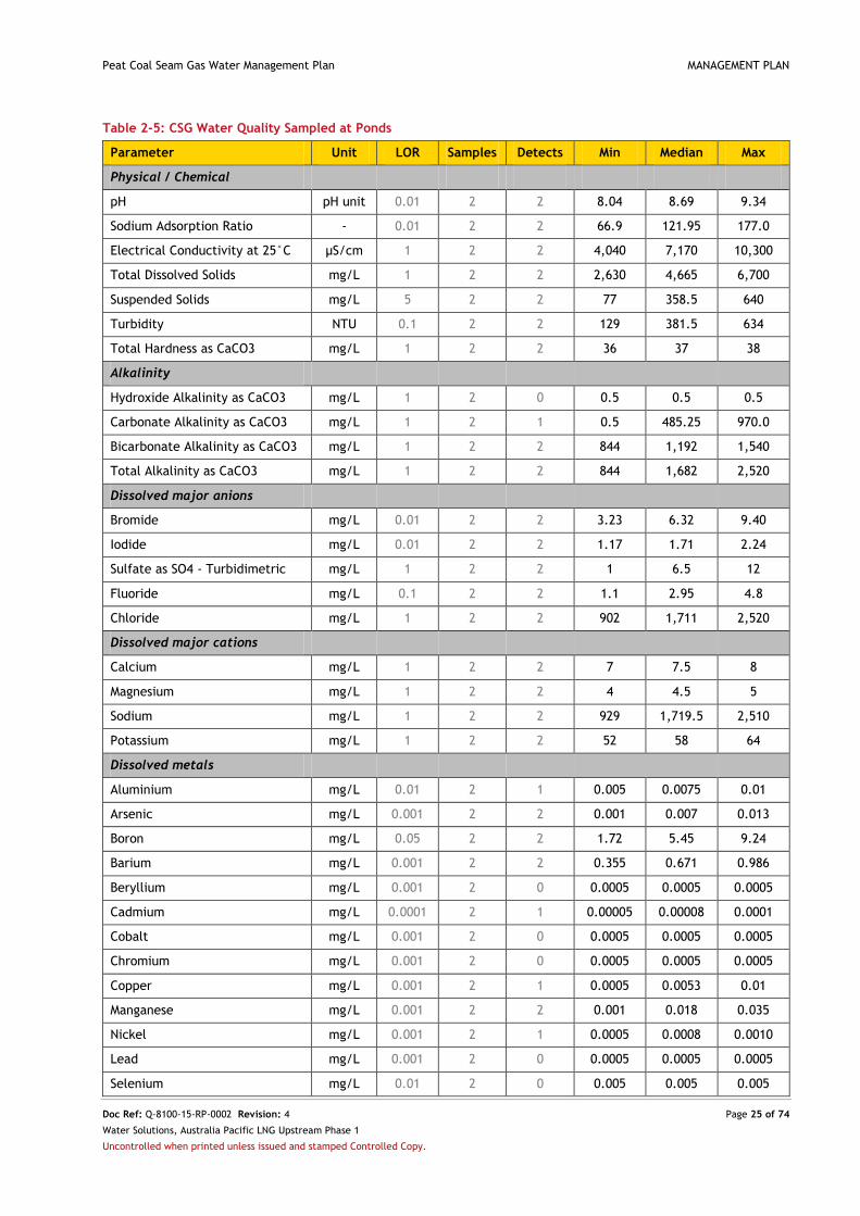
Table 2-4 and Table 2-5 present the latest CSG water quality data for the Peat development area,
collected from operating CSG wells and ponds in July 2014. DEHP has released general beneficial use
approvals (BUAs) (2014a and 2014b) that identify water quality standards to be met when CSG water is
used for stock watering and irrigation. Based on the median quality of CSG water in the Peat
development area (presented in Table 2-4), CSG water is unsuitable for use for irrigation or stock
watering (see further discussion in Section 5.2.1.2).
Once produced, CSG water is initially gathered to CSG water storage ponds. During the period of storage,
the following natural processes act to alter stored water quality:
Mixing and homogenisation of CSG water from CSG wells from across the development area;
Precipitation of metals caused by contact with atmospheric oxygen;
Settling of fine suspended sediment;
Dissolution of carbon dioxide changing the carbonate-bicarbonate balance and altering pH;
Concentration of constituents such as total dissolved solids (TDS) due to evaporation; and
Change in temperature to approach atmospheric values.

Peat Coal Seam Gas Water Management Plan MANAGEMENT PLAN
Doc Ref: Q-8100-15-RP-0002 Revision: 4 Page 22 of 74
Water Solutions, Australia Pacific LNG Upstream Phase 1
Uncontrolled when printed unless issued and stamped Controlled Copy.
Table 2-4: CSG Water Quality Sampled at CSG Wells
Parameter Unit LOR Samples Detects Min Median Max
Physical / Chemical
pH pH unit 0.01 4 4 8.59 8.62 8.66
Sodium Adsorption Ratio - 0.01 4 4 88.8 114.5 116.0
Electrical Conductivity at 25°C µS/cm 1 4 4 4,920 5,125 5,200
Total Dissolved Solids mg/L 1 4 4 3,200 3,330 3,380
Suspended Solids mg/L 5 4 4 12.0 26.0 74.0
Turbidity NTU 0.1 4 4 3.80 9.45 64.00
Total Hardness as CaCO3 mg/L 1 4 4 21.0 21.5 34.0
Alkalinity
Hydroxide Alkalinity as CaCO3 mg/L 1 4 0 0.5 0.5 0.5
Carbonate Alkalinity as CaCO3 mg/L 1 4 4 109.0 124.5 144.0
Bicarbonate Alkalinity as CaCO3 mg/L 1 4 4 1,080 1,135 1,140
Total Alkalinity as CaCO3 mg/L 1 4 4 1,190 1,265 1,270
Dissolved major anions
Bromide mg/L 0.01 4 4 4.19 4.48 5.27
Iodide mg/L 0.01 4 4 0.86 1.50 1.61
Sulfate as SO4 - Turbidimetric mg/L 1 4 1 0.5 0.5 7
Fluoride mg/L 0.1 4 4 2.0 2.35 2.70
Chloride mg/L 1 4 4 905 1,065 1,170
Dissolved major cations
Calcium mg/L 1 4 4 4 5 7
Magnesium mg/L 1 4 4 2.0 2.5 4.0
Sodium mg/L 1 4 4 1,190 1,200 1,250
Potassium mg/L 1 4 4 9.0 26.5 29.0
Dissolved metals
Aluminium mg/L 0.01 4 1 0.005 0.005 0.02
Arsenic mg/L 0.001 4 0 0.0005 0.0005 0.0005
Boron mg/L 0.05 4 4 2.79 3.72 5.23
Barium mg/L 0.001 4 4 0.342 0.475 0.778
Beryllium mg/L 0.001 4 0 0.0005 0.0005 0.0005
Cadmium mg/L 0.0001 4 0 0.00005 0.00005 0.00005
Cobalt mg/L 0.001 4 0 0.0005 0.0005 0.0005
Chromium mg/L 0.001 4 0 0.0005 0.0005 0.0005
Copper mg/L 0.001 4 1 0.0005 0.0005 0.005
Manganese mg/L 0.001 4 4 0.001 0.008 0.086
Nickel mg/L 0.001 4 1 0.0005 0.0005 0.002
Lead mg/L 0.001 4 1 0.0005 0.0005 0.002
Selenium mg/L 0.01 4 0 0.005 0.005 0.005

Peat Coal Seam Gas Water Management Plan MANAGEMENT PLAN
Doc Ref: Q-8100-15-RP-0002 Revision: 4 Page 23 of 74
Water Solutions, Australia Pacific LNG Upstream Phase 1
Uncontrolled when printed unless issued and stamped Controlled Copy.
Parameter Unit LOR Samples Detects Min Median Max
Vanadium mg/L 0.01 4 0 0.005 0.005 0.005
Zinc mg/L 0.005 4 0 0.0025 0.0025 0.0025
Lithium mg/L 0.001 4 4 0.066 0.072 0.081
Molybdenum mg/L 0.001 4 1 0.0005 0.0005 0.010
Dissolved Mercury mg/L 0.0001 4 0 0.00005 0.00005 0.00005
Silver mg/L 0.001 4 0 0.0005 0.0005 0.0005
Strontium mg/L 0.001 4 4 0.735 0.817 1.020
Tin mg/L 0.001 4 0 0.0005 0.0005 0.0005
Uranium mg/L 0.001 4 0 0.0005 0.0005 0.0005
Iron mg/L 0.05 4 1 0.025 0.025 1.23
Gold mg/L 0.001 4 0 0.0005 0.0005 0.0005
Total metals
Aluminium mg/L 0.01 4 4 0.020 0.040 3.030
Arsenic mg/L 0.001 4 1 0.0005 0.0005 0.001
Boron mg/L 0.05 4 4 2.84 3.67 5.14
Barium mg/L 0.001 4 4 0.513 0.580 0.963
Beryllium mg/L 0.001 4 0 0.0005 0.0005 0.0005
Cadmium mg/L 0.0001 4 2 0.00005 0.00008 0.0002
Cobalt mg/L 0.001 4 2 0.0005 0.0008 0.003
Chromium mg/L 0.001 4 4 0.001 0.002 0.058
Copper mg/L 0.001 4 4 0.002 0.021 0.066
Manganese mg/L 0.001 4 4 0.021 0.079 0.474
Nickel mg/L 0.001 4 4 0.001 0.003 0.022
Lead mg/L 0.001 4 4 0.002 0.011 0.032
Selenium mg/L 0.01 4 0 0.005 0.005 0.005
Vanadium mg/L 0.01 4 0 0.005 0.005 0.005
Zinc mg/L 0.005 4 4 0.009 0.058 0.354
Lithium mg/L 0.001 4 4 0.070 0.076 0.081
Molybdenum mg/L 0.001 4 1 0.0005 0.0005 0.009
Total Recoverable Mercury mg/L 0.0001 4 1 0.00005 0.00005 0.0003
Silver mg/L 0.001 4 0 0.0005 0.0005 0.0005
Strontium mg/L 0.001 4 4 0.783 0.914 1.110
Tin mg/L 0.001 4 2 0.0005 0.0008 0.003
Uranium mg/L 0.001 4 0 0.0005 0.0005 0.0005
Iron mg/L 0.05 4 4 1.18 3.275 30.8
Gold mg/L 0.001 4 0 0.0005 0.0005 0.0005
Nutrients
Ammonia as N mg/L 0.01 4 4 1.26 1.67 1.88

Peat Coal Seam Gas Water Management Plan MANAGEMENT PLAN
Doc Ref: Q-8100-15-RP-0002 Revision: 4 Page 24 of 74
Water Solutions, Australia Pacific LNG Upstream Phase 1
Uncontrolled when printed unless issued and stamped Controlled Copy.
Parameter Unit LOR Samples Detects Min Median Max
Nitrite as N mg/L 0.01 4 0 0.005 0.005 0.005
Nitrate as N mg/L 0.01 4 2 0.005 0.0013 0.02
Total Phosphorus as P mg/L 0.01 4 4 0.04 0.06 0.10
Total Organic Carbon mg/L 1 4 4 21.0 26.5 41.0
Phenolic compounds
Phenol µg/L 1 4 0 0.5 0.5 0.5
Polynuclear aromatic hydrocarbons
Naphthalene µg/L 1 4 0 0.5 0.5 0.5
Phenanthrene µg/L 1 4 0 0.5 0.5 0.5
Benzo(a)pyrene µg/L 0.5 4 0 0.25 0.25 0.25
Sum of PAH µg/L 0.5 4 0 0.25 0.25 0.25
Total petroleum hydrocarbons
C6 - C9 Fraction µg/L 20 4 0 10 10 10
C10 - C14 Fraction µg/L 50 4 1 25 25 70
C15 - C28 Fraction µg/L 100 4 3 50 235 500
C29 - C36 Fraction µg/L 50 4 3 25 90 1,180
C10 - C36 Fraction (sum) µg/L 50 4 4 110 305 1,680
BTEX
Benzene µg/L 1 4 0 0.5 0.5 0.5
Toluene µg/L 2 4 0 1 1 1
Ethylbenzene µg/L 2 4 0 1 1 1
meta- & para-Xylene µg/L 2 4 0 1 1 1
ortho-Xylene µg/L 2 4 0 1 1 1
Total Xylenes µg/L 2 4 0 1 1 1
Sum of BTEX µg/L 1 4 0 0.5 0.5 0.5
Radiological
Gross alpha Bq/L 0.08 1 0 0.04 0.04 0.04
Gross beta activity - 40K Bq/L 0.1 1 0 0.05 0.05 0.05
Radium 226 Bq/L 0.05 1 0 0.025 0.025 0.025
Radium 228 Bq/L 0.08 1 0 0.04 0.04 0.04
Lead 210 Bq/L 0.05 1 0 0.025 0.025 0.025
Polonium 210 Bq/L 0.05 1 0 0.025 0.025 0.025
Other
Reactive Silica mg/L 0.05 4 4 20.10 24.45 25.30
Table Notes
When calculating the minimum, median and maximum statistics, half the limit of reporting value is used when a ‘less than limit
of reporting’ value is recorded.
Peat Coal Seam Gas Water Management Plan MANAGEMENT PLAN
Doc Ref: Q-8100-15-RP-0002 Revision: 4 Page 25 of 74
Water Solutions, Australia Pacific LNG Upstream Phase 1
Uncontrolled when printed unless issued and stamped Controlled Copy.
Table 2-5: CSG Water Quality Sampled at Ponds
Parameter Unit LOR Samples Detects Min Median Max
Physical / Chemical
pH pH unit 0.01 2 2 8.04 8.69 9.34
Sodium Adsorption Ratio - 0.01 2 2 66.9 121.95 177.0
Electrical Conductivity at 25°C µS/cm 1 2 2 4,040 7,170 10,300
Total Dissolved Solids mg/L 1 2 2 2,630 4,665 6,700
Suspended Solids mg/L 5 2 2 77 358.5 640
Turbidity NTU 0.1 2 2 129 381.5 634
Total Hardness as CaCO3 mg/L 1 2 2 36 37 38
Alkalinity
Hydroxide Alkalinity as CaCO3 mg/L 1 2 0 0.5 0.5 0.5
Carbonate Alkalinity as CaCO3 mg/L 1 2 1 0.5 485.25 970.0
Bicarbonate Alkalinity as CaCO3 mg/L 1 2 2 844 1,192 1,540
Total Alkalinity as CaCO3 mg/L 1 2 2 844 1,682 2,520
Dissolved major anions
Bromide mg/L 0.01 2 2 3.23 6.32 9.40
Iodide mg/L 0.01 2 2 1.17 1.71 2.24
Sulfate as SO4 - Turbidimetric mg/L 1 2 2 1 6.5 12
Fluoride mg/L 0.1 2 2 1.1 2.95 4.8
Chloride mg/L 1 2 2 902 1,711 2,520
Dissolved major cations
Calcium mg/L 1 2 2 7 7.5 8
Magnesium mg/L 1 2 2 4 4.5 5
Sodium mg/L 1 2 2 929 1,719.5 2,510
Potassium mg/L 1 2 2 52 58 64
Dissolved metals
Aluminium mg/L 0.01 2 1 0.005 0.0075 0.01
Arsenic mg/L 0.001 2 2 0.001 0.007 0.013
Boron mg/L 0.05 2 2 1.72 5.45 9.24
Barium mg/L 0.001 2 2 0.355 0.671 0.986
Beryllium mg/L 0.001 2 0 0.0005 0.0005 0.0005
Cadmium mg/L 0.0001 2 1 0.00005 0.00008 0.0001
Cobalt mg/L 0.001 2 0 0.0005 0.0005 0.0005
Chromium mg/L 0.001 2 0 0.0005 0.0005 0.0005
Copper mg/L 0.001 2 1 0.0005 0.0053 0.01
Manganese mg/L 0.001 2 2 0.001 0.018 0.035
Nickel mg/L 0.001 2 1 0.0005 0.0008 0.0010
Lead mg/L 0.001 2 0 0.0005 0.0005 0.0005
Selenium mg/L 0.01 2 0 0.005 0.005 0.005

Peat Coal Seam Gas Water Management Plan MANAGEMENT PLAN
Doc Ref: Q-8100-15-RP-0002 Revision: 4 Page 26 of 74
Water Solutions, Australia Pacific LNG Upstream Phase 1
Uncontrolled when printed unless issued and stamped Controlled Copy.
Parameter Unit LOR Samples Detects Min Median Max
Vanadium mg/L 0.01 2 1 0.005 0.0425 0.080
Zinc mg/L 0.005 2 1 0.0025 0.0098 0.0170
Lithium mg/L 0.001 2 2 0.049 0.069 0.089
Molybdenum mg/L 0.001 2 1 0.0005 0.0028 0.0050
Dissolved Mercury mg/L 0.0001 2 0 0.00005 0.00005 0.00005
Silver mg/L 0.001 2 0 0.0005 0.0005 0.0005
Strontium mg/L 0.001 2 2 0.713 1.152 1.59
Tin mg/L 0.001 2 0 0.0005 0.0005 0.0005
Uranium mg/L 0.001 2 1 0.0005 0.0038 0.0070
Iron mg/L 0.05 2 1 0.025 0.538 1.050
Gold mg/L 0.001 2 0 0.0005 0.0005 0.0005
Total metals
Aluminium mg/L 0.01 2 2 0.02 10.21 20.40
Arsenic mg/L 0.001 2 2 0.001 0.0065 0.012
Boron mg/L 0.05 2 2 1.73 5.39 9.05
Barium mg/L 0.001 2 2 0.496 1.368 2.240
Beryllium mg/L 0.001 2 0 0.0005 0.0005 0.0005
Cadmium mg/L 0.0001 2 1 0.0001 0.0003 0.0005
Cobalt mg/L 0.001 2 1 0.0005 0.0038 0.0070
Chromium mg/L 0.001 2 1 0.0005 0.0058 0.011
Copper mg/L 0.001 2 2 0.002 0.014 0.026
Manganese mg/L 0.001 2 2 0.041 0.1925 0.344
Nickel mg/L 0.001 2 1 0.0005 0.0043 0.008
Lead mg/L 0.001 2 1 0.0005 0.0058 0.011
Selenium mg/L 0.01 2 0 0.005 0.005 0.005
Vanadium mg/L 0.01 2 1 0.005 0.0625 0.120
Zinc mg/L 0.005 2 2 0.043 0.071 0.098
Lithium mg/L 0.001 2 2 0.057 0.092 0.127
Molybdenum mg/L 0.001 2 1 0.0005 0.0018 0.0030
Total Recoverable Mercury mg/L 0.0001 2 0 0.00005 0.00005 0.00005
Silver mg/L 0.001 2 0 0.005 0.005 0.005
Strontium mg/L 0.001 2 2 0.771 1.646 2.52
Tin mg/L 0.001 2 0 0.005 0.005 0.005
Uranium mg/L 0.001 2 1 0.0005 0.0043 0.008
Iron mg/L 0.05 2 1 2.02 9.36 16.7
Gold mg/L 0.001 2 0 0.005 0.005 0.005
Nutrients
Ammonia as N mg/L 0.01 2 2 0.02 0.33 0.64

Peat Coal Seam Gas Water Management Plan MANAGEMENT PLAN
Doc Ref: Q-8100-15-RP-0002 Revision: 4 Page 27 of 74
Water Solutions, Australia Pacific LNG Upstream Phase 1
Uncontrolled when printed unless issued and stamped Controlled Copy.
Parameter Unit LOR Samples Detects Min Median Max
Nitrite as N mg/L 0.01 2 0 0.005 0.005 0.005
Nitrate as N mg/L 0.01 2 2 0.01 0.02 0.02
Total Phosphorus as P mg/L 0.01 2 2 0.42 1.31 2.20
Total Organic Carbon mg/L 1 2 2 1 85.5 170
Phenolic compounds
Phenol µg/L 1 2 0 0.5 0.5 0.5
Polynuclear aromatic hydrocarbons
Naphthalene µg/L 1 2 0 0.5 0.5 0.5
Phenanthrene µg/L 1 2 0 0.5 0.5 0.5
Benzo(a)pyrene µg/L 0.5 2 0 0.25 0.25 0.25
Sum of PAH µg/L 0.5 2 0 0.25 0.25 0.25
Total petroleum hydrocarbons
C6 - C9 Fraction µg/L 20 2 0 10 10 10
C10 - C14 Fraction µg/L 50 2 1 25 862.5 1,700
C15 – C28 Fraction µg/L 100 2 2 100 2,990 5,880
C29 – C36 Fraction µg/L 50 2 2 60 7,430 14,800
C10 – C36 Fraction (sum) µg/L 50 2 2 160 11,280 22,400
BTEX
Benzene µg/L 1 2 0 0.5 0.5 0.5
Toluene µg/L 2 2 0 1 1 1
Ethylbenzene µg/L 2 2 0 1 1 1
meta- & para-Xylene µg/L 2 2 0 1 1 1
ortho-Xylene µg/L 2 2 0 1 1 1
Total Xylenes µg/L 2 2 0 1 1 1
Sum of BTEX µg/L 1 2 0 0.5 0.5 0.5
Radiological
Gross alpha Bq/L 0.08 2 2 0.07 0.15 0.23
Gross beta activity - 40K Bq/L 0.1 2 0 0.05 0.05 0.05
Radium 226 Bq/L 0.05 2 1 0.025 0.06 0.09
Radium 228 Bq/L 0.08 2 2 0.08 0.11 0.13
Lead 210 Bq/L 0.05 2 0 0.025 0.025 0.025
Polonium 210 Bq/L 0.05 2 1 0.025 0.12 0.21
Other
Reactive Silica mg/L 0.05 2 2 3.56 12.03 20.50
Table Notes
When calculating the minimum, median and maximum statistics, half the limit of reporting value is used when a ‘less than limit
of reporting’ value is recorded.

Peat Coal Seam Gas Water Management Plan MANAGEMENT PLAN
Doc Ref: Q-8100-15-RP-0002 Revision: 4 Page 28 of 74
Water Solutions, Australia Pacific LNG Upstream Phase 1
Uncontrolled when printed unless issued and stamped Controlled Copy.
3. Existing Environment
The following chapter provides an overview of the existing environment of the Peat development area.
3.1. Climate
Regional climate data is recorded by the Australian Government Bureau of Meteorology (BoM) at
Wandoan Post Office, Taroom Post Office and Miles Post Office. Based on data recorded at these sites,
the climate of the Peat development area can be summarised as follows and as shown in Figure 3-1:
Sub-tropical and semi-arid with relatively warm and wetter summers and relatively mild and
drier winters;
Mean daily maximum temperatures ranging between 21°C in winter and 34°C in summer;
Mean daily minimum temperatures ranging between 5°C in winter and 21°C in summer;
Mean monthly rainfall ranging between 28 mm in winter and 98 mm in summer; and
Mean monthly evaporation ranging between 60 mm in winter and 226 mm in summer.
Mean maximum and minimum daily temperature recorded at Taroom Post Office (BoM Site Number 035070), 45 km
northwest of the Peat development area. Mean monthly rainfall recorded at Wandoan Post Office (BoM Site
Number 035014), 9 km west of the Peat development area. Mean monthly evaporation recorded at Miles Post Office
(BoM Site Number 042023) 45 km south of the Peat development area.
Figure 3-1: Regional Climate
3.2. Land
3.2.1. Topography and Landscape
The landscape of the Peat development area is characterised by low hills and undulating plains
supporting Brigalow scrub and open forest. The development area lies within the Taroom Downs province
of the Brigalow Belt bioregion and vegetation is dominated by Acacia harpophylla (Brigalow).

Peat Coal Seam Gas Water Management Plan MANAGEMENT PLAN
Doc Ref: Q-8100-15-RP-0002 Revision: 4 Page 29 of 74
Water Solutions, Australia Pacific LNG Upstream Phase 1
Uncontrolled when printed unless issued and stamped Controlled Copy.
3.2.2. Geology and Soil
The Peat development area lies within the Surat Basin which in turn, overlies the Bowen Basin. The
major geological formations in the region are the Back Creek Group, Blackwater Group, Rewan
Formation and Wandoan Formation. The target formation for CSG extraction is the Baralaba Formation,
located at a depth of between 650 m and 1,300 m.
The soils of the region are mainly brown and black non-cracking clays and gilgaied grey cracking clays
with highly erodible subsoils. These soils are typical of the region and are considered vulnerable to
sheet, rill and gully erosion, particularly where large areas have been cleared and sub-soils exposed.
3.2.3. Land Use
Land use in the Peat development area is dominated by the grazing of native vegetation with some non-
irrigated cropping (see Table 3-1). Potential strategic cropping land (SCL) triggered as the Strategic
Cropping Area under the Regional Planning Interests Act 2014 (Qld) covers the majority of the
development area.
Minor land uses by area include irrigated cropping, intensive animal husbandry, mining and utilities. No
townships lie within the development area however rural homesteads are scattered across its extent.
Table 3-1: Land Use in the Peat Development Area
Land Use Category Land within
Peat Development Area (ha)
Percentage of
Peat Development Area
Grazing of native vegetation 19,829 82.5
Cropping (non-irrigated) 3,988 16.6
Surface waters 67 0.28
Irrigated cropping 15 0.06
Intensive animal husbandry 9 0.04
Mining 3 0.01
Utilities 3 0.01
Other 124 0.52
Table Notes
Source: Queensland Land Use Mapping Program, see http://www.qld.gov.au/environment/land/vegetation/mapping/qlump/
3.3. Groundwater
The hydrogeology of the Peat development area is characterised by alternating sandstone aquifers and
siltstone/mudstone aquitards in both the Surat and Bowen Basins. The Injune Creek Group outcrops in
the northern part of Peat development area.
Although a number of aquifer formations are present beneath the Peat development area, existing
groundwater users tend to target the shallowest available formation that meets their water quality and
quantity requirements. A baseline assessment of landholder bores in the Peat development area
identified 25 operational bores, most of which extract groundwater from the Hutton Sandstone
Formation (see Table 3-2). Water quality in these formations is variable and at 24 of the bores,
groundwater is extracted for stock and domestic use. Groundwater from the other bore is used for stock
and domestic purposes and irrigation.

Peat Coal Seam Gas Water Management Plan MANAGEMENT PLAN
Doc Ref: Q-8100-15-RP-0002 Revision: 4 Page 30 of 74
Water Solutions, Australia Pacific LNG Upstream Phase 1
Uncontrolled when printed unless issued and stamped Controlled Copy.
Table 3-2: Landholder Bore Assessment
Target Formation / Aquifer Number of
Operational Bores
Groundwater Use for
Stock and Domestic
Groundwater Use for Stock,
Domestic and Irrigation
Injune Creek Group 5 5 -
Hutton Sandstone 10 10 -
Precipice Sandstone 8 7 1
Unknown 2 2 -
TOTAL 25 24 1
3.4. Surface Water
The Peat development area lies within the Dawson River catchment, part of the broader Fitzroy Basin,
and is crossed by a number of ephemeral creeks (typically stream order 3 or less) that generally flow in
westerly and northerly directions to the Dawson River. The most significant of these ephemeral creeks
are Juandah Creek (stream order 4), running southeast to northwest across the far southwest corner of
the development area, and Roche Creek (also stream order 4), running east to west across the north of
the development area. There are no Declared Wild River Areas in the development area.
The existing CSG water storage ponds of the Peat development area all lie within the catchment of
Roche Creek. The course of Roche Creek runs west-northwest for approximately 45 km before joining
Juandah Creek. In turn, Juandah Creek flows into Dawson River a further 40 km downstream.
3.5. Environmentally Sensitive Areas and Biodiversity Values
DEHP mapping2 has identified the following environmentally sensitive areas (ESAs) within the Peat
development area:
Category A – None;
Category B – Endangered regional ecosystems (remnant and mature regrowth – biodiversity
status) in two (2) narrow bands in the north of the development area; and
Category C – Of concern regional ecosystem (remnant biodiversity status) in small and
restricted areas of the south and west of the development area.
Australia Pacific LNG has an ongoing program of ground-truthing ESAs in accordance with the Constraints
Planning and Field Development Protocol (Q-LNG01-15-MP-0109) and the Disturbance Procedure (OEUP-
Q1000-PRO-ENV-001). Essential habitat for fauna species and threatened fauna and flora species listed
under the Nature Conservation Act 1992 (Qld) have been identified in the development area and will
also undergo ground-truthing.
2 Available at http://www.ehp.qld.gov.au/licences-permits/maps_of_environmentally_sensitive_areas.php
Peat Coal Seam Gas Water Management Plan MANAGEMENT PLAN
Doc Ref: Q-8100-15-RP-0002 Revision: 4 Page 31 of 74
Water Solutions, Australia Pacific LNG Upstream Phase 1
Uncontrolled when printed unless issued and stamped Controlled Copy.
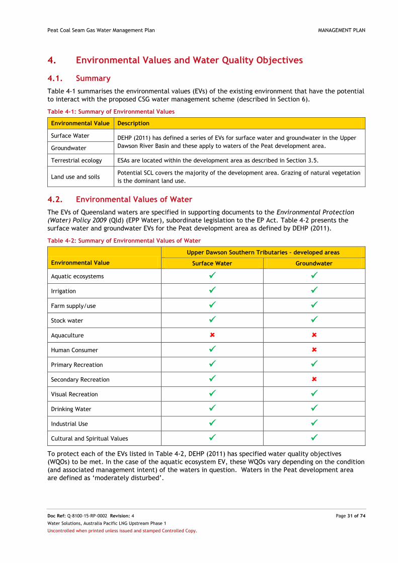
4. Environmental Values and Water Quality Objectives
4.1. Summary
Table 4-1 summarises the environmental values (EVs) of the existing environment that have the potential
to interact with the proposed CSG water management scheme (described in Section 6).
Table 4-1: Summary of Environmental Values
Environmental Value Description
Surface Water DEHP (2011) has defined a series of EVs for surface water and groundwater in the Upper
Dawson River Basin and these apply to waters of the Peat development area. Groundwater
Terrestrial ecology ESAs are located within the development area as described in Section 3.5.
Land use and soils Potential SCL covers the majority of the development area. Grazing of natural vegetation
is the dominant land use.
4.2. Environmental Values of Water
The EVs of Queensland waters are specified in supporting documents to the Environmental Protection
(Water) Policy 2009 (Qld) (EPP Water), subordinate legislation to the EP Act. Table 4-2 presents the
surface water and groundwater EVs for the Peat development area as defined by DEHP (2011).
Table 4-2: Summary of Environmental Values of Water
Environmental Value
Upper Dawson Southern Tributaries – developed areas
Surface Water Groundwater
Aquatic ecosystems
Irrigation
Farm supply/use
Stock water
Aquaculture
Human Consumer
Primary Recreation
Secondary Recreation
Visual Recreation
Drinking Water
Industrial Use
Cultural and Spiritual Values
To protect each of the EVs listed in Table 4-2, DEHP (2011) has specified water quality objectives
(WQOs) to be met. In the case of the aquatic ecosystem EV, these WQOs vary depending on the condition
(and associated management intent) of the waters in question. Waters in the Peat development area
are defined as ‘moderately disturbed’.

Peat Coal Seam Gas Water Management Plan MANAGEMENT PLAN
Doc Ref: Q-8100-15-RP-0002 Revision: 4 Page 32 of 74
Water Solutions, Australia Pacific LNG Upstream Phase 1
Uncontrolled when printed unless issued and stamped Controlled Copy.
5. CSG Water Management Strategy
This chapter of the CWMP describes and justifies the strategy for managing CSG water produced in the
Peat development area.
5.1. Drivers behind the Strategy
The development of a revised strategy for CSG water management in the Peat development area has
been influenced by three (3) primary drivers, as discussed in the following sub-sections.
5.1.1. Addressing the Conditions of the Peat EA
This CWMP has been prepared to document a review of, and revision to, the current CSG water
management strategy. It aims to ensure that the implemented options continue to reflect the most
appropriate solution for the development area. As such, this CWMP meets Condition (D8) and (D9) of the
Peat EA.
CSG production in the Peat development area commenced in 2000 and the associated CSG water
management infrastructure was constructed in accordance with the industry standards that prevailed at
that time. Notwithstanding this situation, Australia Pacific LNG acknowledges the need to address
Condition (D3) of the Peat EA which requires that:
Existing (D3) The holder of this authority must ensure that any ponds used as a primary means of
disposal of associated water [CSG water], are decommissioned, remediated and the
area rehabilitated to final land use standard by 1 November 2011.
This CWMP supports an application to amend Condition (D3) of the Peat EA and to add a new Condition
(D16) as follows:
Amended (D3): Subject to Condition (D16), the holder of this authority must ensure that any ponds
used as a primary means of disposal of associated water are decommissioned by 1
November 2011.
New (D16): Despite Condition (D3) of this environmental authority, Peat GPF Pond 2 may be used
as a primary means of disposal of associated water
5.1.2. Ensuring Alignment to the CSG Water Management Policy
The proposed strategy for CSG water management has been developed in accordance with the DEHP
prioritisation hierarchy. This hierarchy is published in the CSG Water Management Policy (DEHP 2012a)
and is presented in Figure 5-1. In line with the requirements of the policy, Priority 1 options have been
preferentially investigated with the intention they are implemented wherever they are proven feasible.
1
Prioritisation Hierarchy for Managing and Using CSG Water
2Treating and disposing of CSG water in a way that
firstly avoids, and then minimises and mitigates
impacts on environmental values.
1 Brine or salt residues are treated to create usable
products wherever feasible
2 Disposing of brine or salt residues in accordance
with strict standards that protect the environment
Using CSG water for a purpose that is beneficial to
one or more of the following:
The environment
Existing or new water users
Existing or new water-dependent industries
Prioritisation Hierarchy for Managing Saline Waste
Figure 5-1: DEHP Hierarchy for CSG Water Management

Peat Coal Seam Gas Water Management Plan MANAGEMENT PLAN
Doc Ref: Q-8100-15-RP-0002 Revision: 4 Page 33 of 74
Water Solutions, Australia Pacific LNG Upstream Phase 1
Uncontrolled when printed unless issued and stamped Controlled Copy.
In order to determine the most appropriate beneficial uses of CSG water (Priority 1 options on the DEHP
prioritisation hierarchy), Australia Pacific LNG has conducted a needs analysis of local water users,
considering those options that:
1. Are closest to the region of extraction;
2. Provide water to existing water users in the region of extraction; and
3. Provide water to new water dependent industries or users in the region of extraction.
Any brine or salt residues created as a result of evaporation from ponds in the Peat development area
will be managed in accordance with the DEHP hierarchy for saline waste.
In addition to being developed in accordance with the DEHP prioritisation hierarchies, the strategy for
CSG water management also gives due regard to the waste and resource management hierarchy outlined
in the Waste Reduction and Recycling Act 2011 (Qld) and presented in Figure 5-2.
Figure 5-2: Waste and Resource Management Hierarchy
5.1.3. Characteristics of the Peat Development Area
CSG water production in the Peat development area has several characteristics that influence the
suitability of alternative management options.
1. The rates of CSG water production from the development area are low and are significantly
lower than those observed in other Australia Pacific LNG development areas.;
2. The Peat development area is located a significant distance from other Australia Pacific LNG
development areas (the Combabula development area is the closest, in excess of a 75 km
straight-line distance to the west). It is also located in a region with spatially dispersed water
users (see outcomes of local needs analysis – Section 5.2.1); and
3. The Peat development area is a mature asset with no approved plans for expansion. As such, the
rate of CSG water production is predicted to gradually decline over time. This projected trend
limits the benefit that could otherwise be realised by developing CSG water management
solutions that require large investments in extensive and/or complex infrastructure.
5.2. Approach to Developing the Strategy
Australia Pacific LNG has evaluated the potential performance of more than 70 CSG water management
options for its development areas across south central Queensland. These options are grouped into the
six (6) categories presented in Table 5-1.
• AVOID unnecessary resource consumption 1
• REDUCE waste generation and disposal 2
• RE-USE waste resources without further manufacturing 3
• RECYCLE waste resources to make the same or different products 4
• RECOVER waste resources, including the recovery of energy 5
• TREAT waste before disposal, including reducing the hazardous nature of the waste 6 • DISPOSE of waste only if there is no viable alternative 7

Peat Coal Seam Gas Water Management Plan MANAGEMENT PLAN
Doc Ref: Q-8100-15-RP-0002 Revision: 4 Page 34 of 74
Water Solutions, Australia Pacific LNG Upstream Phase 1
Uncontrolled when printed unless issued and stamped Controlled Copy.
Table 5-1: Categories of CSG Water Management Option
Category Description Position on DEHP
Hierarchy
Municipal use Supply of treated CSG water to townships and into existing municipal
water networks. Priority 1
Agriculture Supply of treated CSG water for agricultural uses including:
a) Existing irrigated cropping or livestock watering operations.
b) To support new irrigation or livestock watering schemes.
c) Agricultural ventures operated by Australia Pacific LNG.
Priority 1
Industrial use Supply of untreated or treated CSG water to industrial users such as
mines (for coal washing for example) and power stations (for cooling). Priority 1
Project
activities
Use of untreated or treated CSG water to support Australia Pacific LNG
Project activities such as dust suppression and construction. Priority 1
Injection Injection of treated CSG water to a depleted aquifer. Priority 1
Beneficial use
schemes
Schemes that combine one or more of the above options in an
integrated beneficial use scheme. Priority 1
Release to
improve EVs
Release to the environment in a manner that improves local
environmental values. Priority 1
Injection Injection of untreated or treated CSG water to a basement formation. Priority 2
Release to
surface water
Release of treated CSG water to surface watercourses in a manner that
ensures the protection of environmental values. Priority 2
In order to determine the most appropriate strategy for managing CSG water in the Peat development
area, each of the option categories in Table 5-1 has undergone a thorough and robust evaluation process
comprising the following two (2) stages:
A water needs analysis and option performance evaluation specific to the Peat development
area, and
A detailed environmental value risk assessment.
Based on the outcomes of these two processes, options were either incorporated into the CSG water
management strategy for the development area or else discounted as currently infeasible. Infeasible
options will still be reconsidered during updates to the CWMP (as described in Section 12).
5.2.1. Local Needs Analysis and Option Performance Evaluation
The following sub-sections identify the local needs for water in the Peat development area and analyse
options for supplying CSG water to meet these demands. For each option, consideration has also been
given to likely performance against the selection criteria outlined in Table 5-2.
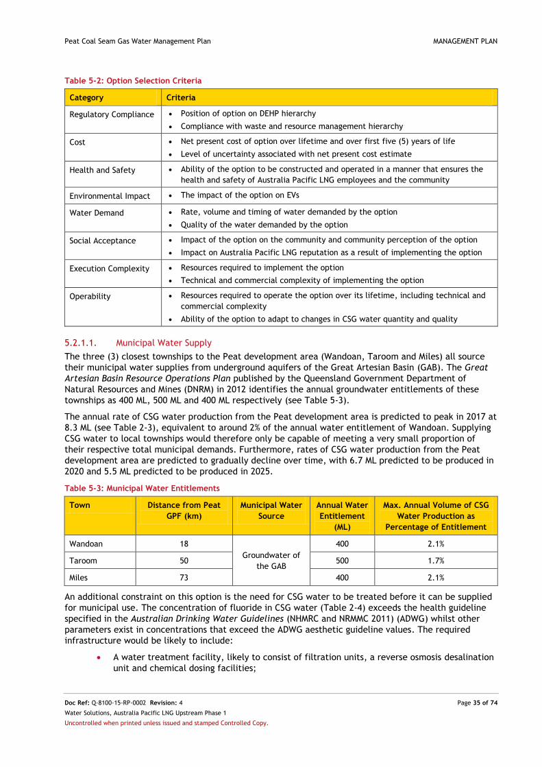
Peat Coal Seam Gas Water Management Plan MANAGEMENT PLAN
Doc Ref: Q-8100-15-RP-0002 Revision: 4 Page 35 of 74
Water Solutions, Australia Pacific LNG Upstream Phase 1
Uncontrolled when printed unless issued and stamped Controlled Copy.
Table 5-2: Option Selection Criteria
Category Criteria
Regulatory Compliance Position of option on DEHP hierarchy
Compliance with waste and resource management hierarchy
Cost Net present cost of option over lifetime and over first five (5) years of life
Level of uncertainty associated with net present cost estimate
Health and Safety Ability of the option to be constructed and operated in a manner that ensures the
health and safety of Australia Pacific LNG employees and the community
Environmental Impact The impact of the option on EVs
Water Demand Rate, volume and timing of water demanded by the option
Quality of the water demanded by the option
Social Acceptance Impact of the option on the community and community perception of the option
Impact on Australia Pacific LNG reputation as a result of implementing the option
Execution Complexity Resources required to implement the option
Technical and commercial complexity of implementing the option
Operability Resources required to operate the option over its lifetime, including technical and
commercial complexity
Ability of the option to adapt to changes in CSG water quantity and quality
5.2.1.1. Municipal Water Supply
The three (3) closest townships to the Peat development area (Wandoan, Taroom and Miles) all source
their municipal water supplies from underground aquifers of the Great Artesian Basin (GAB). The Great
Artesian Basin Resource Operations Plan published by the Queensland Government Department of
Natural Resources and Mines (DNRM) in 2012 identifies the annual groundwater entitlements of these
townships as 400 ML, 500 ML and 400 ML respectively (see Table 5-3).
The annual rate of CSG water production from the Peat development area is predicted to peak in 2017 at
8.3 ML (see Table 2-3), equivalent to around 2% of the annual water entitlement of Wandoan. Supplying
CSG water to local townships would therefore only be capable of meeting a very small proportion of
their respective total municipal demands. Furthermore, rates of CSG water production from the Peat
development area are predicted to gradually decline over time, with 6.7 ML predicted to be produced in
2020 and 5.5 ML predicted to be produced in 2025.
Table 5-3: Municipal Water Entitlements
Town Distance from Peat
GPF (km)
Municipal Water
Source
Annual Water
Entitlement
(ML)
Max. Annual Volume of CSG
Water Production as
Percentage of Entitlement
Wandoan 18
Groundwater of
the GAB
400 2.1%
Taroom 50 500 1.7%
Miles 73 400 2.1%
An additional constraint on this option is the need for CSG water to be treated before it can be supplied
for municipal use. The concentration of fluoride in CSG water (Table 2-4) exceeds the health guideline
specified in the Australian Drinking Water Guidelines (NHMRC and NRMMC 2011) (ADWG) whilst other
parameters exist in concentrations that exceed the ADWG aesthetic guideline values. The required
infrastructure would be likely to include:
A water treatment facility, likely to consist of filtration units, a reverse osmosis desalination
unit and chemical dosing facilities;

Peat Coal Seam Gas Water Management Plan MANAGEMENT PLAN
Doc Ref: Q-8100-15-RP-0002 Revision: 4 Page 36 of 74
Water Solutions, Australia Pacific LNG Upstream Phase 1
Uncontrolled when printed unless issued and stamped Controlled Copy.
Treated water and brine storage facilities (to separately manage the treated CSG water and
waste brine products generated as a result of desalination);
Investment in a long-term brine and salt management solution/s;
Power supplies for treatment equipment and pumping facilities;
Chemical storage facilities; and
Ancillary pipeline infrastructure (refer Table 5-3 for distance) to town location or
implementation of water transport via trucking.
Australia Pacific LNG has undertaken an estimation of the capital and operating costs of the above
infrastructure. Given the small volumes of CSG water expected to be produced (an annual maximum of
8.3 ML in 2017, see Table 2-3), for each megalitre of CSG water that could be treated, the cost of the
required infrastructure is far higher than is the case for other development areas of the Australia Pacific
LNG Project (where CSG water production rates are higher). The cost assessment identified that the per
megalitre operating costs of a WTF in the Peat development area would be more than 50 times that of
other Australia Pacific LNG water management schemes. Furthermore, committing to this infrastructure
in order to meet such a small proportion of a township’s municipal water demand, and only for a limited
period of time, is not considered to represent a socially, environmentally or economically beneficial
solution.
5.2.1.2. Agricultural Use
Existing Agricultural Schemes - Irrigation and Stock Watering
Agricultural uses of water include irrigation and stock watering. Maps from the Queensland Land Use
Mapping Program (QLUMP)3 were evaluated to determine the likely water demands from existing
agricultural users in the Peat development area. Figure 5-3 identifies a single small (15 ha) land parcel
supporting irrigated cropping (see Table 5-4) approximately 23 km south of the Peat GPF.
The QLUMP mapping also identifies a small area of ‘intensive animal husbandry’ on the western
boundary of the development area, approximately 12 km southwest of the Peat GPF. Data from the
Queensland Government Department of Agriculture Fisheries and Forestry (DAFF) suggests that this land
corresponds to a feedlot supporting a maximum 999 head of cattle (see Table 5-5). Two (2) other
feedlots within the development area support a combined maximum of 800 head of cattle and are
located 13 km south and 14 km southwest of the Peat GPF respectively. A feedlot 10 km to the
northwest of the Peat GPF but outside the Peat development area supports a maximum of 499 cattle.
Table 9.3.1 of the Australian and New Zealand Guidelines for Fresh and Marine Water Quality (ANZECC
and ARMCANZ 2000) (ANZECC Guideline) indicates that on average, daily water consumption by beef
cattle is in the order of 45 L/head. Using this estimate, the four (4) feedlots within 15 km of the Peat
GPF could require around 0.103 ML of stock water a day at maximum stocking capacity. It is therefore
possible that the predicted peak rate of CSG water production from the Peat development area (0.024
ML/d) could meet the stock watering demand of one (1) of these feedlots for a limited period of time.
However, as CSG water production is predicted to gradually decline over time, an additional water
supply (and the associated duplication of water supply infrastructure) would also be required by the
feedlot owner. Investment in multiple water supply schemes is unlikely to be cost effective and would
also create complex operational constraints. For reference, Table 5-5 also identifies other feedlots and
piggeries within the region immediately beyond the Peat development area boundary.
General BUAs (DEHP 2014a and 2014b) specify water quality guidelines for stock watering and irrigation
respectively and also impart obligations on the producers and users of the CSG water resource. Table 5-6
presents the water quality criteria from the respective General BUAs against CSG water quality data
reproduced from Table 2-4. This comparison shows that CSG water from the Peat development area is
likely to require treatment prior to use for either irrigation or stock watering. The maximum electrical
conductivity, sodium adsorption ratio, pH, iron concentration and fluoride concentration of CSG water
exceed the General BUA requirements for irrigation whilst the maximum concentration of fluoride and
3 See http://www.qld.gov.au/environment/land/vegetation/mapping/qlump/

Peat Coal Seam Gas Water Management Plan MANAGEMENT PLAN
Doc Ref: Q-8100-15-RP-0002 Revision: 4 Page 37 of 74
Water Solutions, Australia Pacific LNG Upstream Phase 1
Uncontrolled when printed unless issued and stamped Controlled Copy.
boron in CSG water exceeds the General BUA requirement for stock watering. The water treatment
infrastructure constraints outlined in Section 3.2.1.1 are therefore also relevant to the option of
supplying CSG water to agricultural users.
In order to understand the demand for CSG water from landholders in the vicinity of the Peat GPF,
Australia Pacific LNG completed a consultation process in December 2014. Table 5-7 lists the
landholders that were consulted and their locations relative to CSG water management infrastructure.
All of the landholders consulted confirmed that they would not be willing to accept CSG water at the
qualities and in the volumes expected for the Peat development area.
The option of providing CSG water to supplement larger regional agricultural supply schemes is
considered in Section 5.2.1.6.
New Agricultural Schemes – Irrigation and Stock Watering
An alternative to supplying existing agricultural schemes is for Australia Pacific LNG to either establish
its own agricultural venture, or to supply local landholders with CSG water for this purpose. Australia
Pacific LNG has successfully implemented this approach in both the Spring Gully development area
(around 100 km west of the Peat development area) and in the Talinga/Condabri region (around 100 km
to the south). However, in these cases, the success of the schemes has been reliant on sustained rates of
CSG water production over many years. In the Peat development area, the predicted gradual decline in
CSG water production prevents the establishment of a long-term sustainable agricultural venture that
would otherwise provide social benefit. Any agricultural scheme in the Peat development area would
require an alternative water supply on which it would become increasingly reliant. The necessary
duplication of infrastructure therefore makes the development of, or support for, a new agricultural
venture by Australia Pacific LNG environmentally and economically infeasible. Furthermore, as for
existing agricultural schemes, CSG water would require treatment (and the development of necessary
infrastructure) prior to use at new agricultural ventures.

Peat Coal Seam Gas Water Management Plan MANAGEMENT PLAN
Doc Ref: Q-8100-15-RP-0002 Revision: 4 Page 38 of 74
Water Solutions, Australia Pacific LNG Upstream Phase 1
Uncontrolled when printed unless issued and stamped Controlled Copy.
Figure 5-3: Land Use, Feedlots and Piggeries

Peat Coal Seam Gas Water Management Plan MANAGEMENT PLAN
Doc Ref: Q-8100-15-RP-0002 Revision: 4 Page 39 of 74
Water Solutions, Australia Pacific LNG Upstream Phase 1
Uncontrolled when printed unless issued and stamped Controlled Copy.
Table 5-4: Land Use in the Peat Development Area
Land Use Category Land within Peat Development Area (ha)
Percentage of Peat Development Area
Grazing of native vegetation 19,829 82.5 %
Cropping (non-irrigated) 3,988 16.6 %
Surface waters 67 0.28 %
Irrigated cropping 15 0.06 %
Intensive animal husbandry 9 0.04 %
Mining 3 0.01 %
Utilities 3 0.01 %
Other 124 0.52 %
Table Notes
Data source: http://www.qld.gov.au/environment/land/vegetation/mapping/qlump/
Table 5-5: Existing Cattle Feedlots and Piggeries
Ref. Distance A from Peat GPF (km) Registered Maximum Operating
Capacity (head of cattle)
Water Demand for Stock
Watering (ML/d) B
Cattle Feedlot
1 13 500 0.023
2 14 300 0.014
3 11.5 999 0.045
4 26.5 985 0.044
5 28.5 499 0.022
6 27.5 499 0.022
7 31 499 0.022
8 10 499 0.022
9 33.5 5,000 0.225
10 22 150 0.007
11 23 150 0.007
Piggery
A 26 60 0.001
Table Notes
A – Direct distance. If water supply were to be via tanker, travelled distance would be greater.
B - Stock water requirements for both cattle and pigs as stated in Table 9.3.1 of the Australian and New Zealand Guidelines for
Fresh and Marine Water Quality (ANZECC and ARMCANZ 2000)

Peat Coal Seam Gas Water Management Plan MANAGEMENT PLAN
Doc Ref: Q-8100-15-RP-0002 Revision: 4 Page 40 of 74
Water Solutions, Australia Pacific LNG Upstream Phase 1
Uncontrolled when printed unless issued and stamped Controlled Copy.
Table 5-6: Water Quality Limit Levels for Irrigation and Stock Watering
Parameter Unit Water Quality Limit for
Irrigation A
Water Quality Limit for
Stock Watering B
CSG Water
Quality C
Electrical conductivity µS/cm 950 D No limit 5,200
Sodium adsorption ratio - 6 E No limit 116
pH - 6.0 – 8.5 F No limit 8.66
Total dissolved solids mg/L No limit 4,000 G 3,380
Aluminium mg/L 20 5 3.03
Arsenic mg/L 2 0.5 0.001
Boron mg/L Crop dependent H 5 5.14
Cadmium mg/L 0.05 0.01 0.0002
Chromium mg/L 1 1 0.058
Cobalt mg/L 0.1 1 0.003
Copper mg/L 5 1 I 0.066
Fluoride mg/L 2 2 2.7
Iron mg/L 10 No limit 30.8
Lithium mg/L 2.5 No limit 0.081
Lead mg/L 5 0.1 0.032
Manganese mg/L 10 No limit 0.474
Mercury mg/L 0.002 0.002 0.0003
Molybdenum mg/L 0.05 0.15 0.009
Nickel mg/L 2 1 0.022
Selenium mg/L No limit 0.02 <0.01
Uranium mg/L No limit 0.2 <0.001
Zinc mg/L 5 20 0.354
Gross alpha Bq/L No limit 0.5 <0.08
Gross beta (excl. K-40) Bq/L No limit 0.5 <0.1
Radium 226 Bq/L No limit 5 <0.05
Radium 228 Bq/L No limit 2 <0.08
Table Notes A As in the General Beneficial Use Approval: Irrigation of Associated water (including coal seam gas water) (DEHP 2014b). B As in the General Beneficial Use Approval: Associated water (including coal seam gas water) (DEHP 2014a). Water quality limit
levels for stock watering assume that stock feed contains no heavy metals. C Maximum value for the Peat development area
based on data from operating CSG wells in 2014. See Table 2-4 for full suite. D As a 95th percentile over one-year period. E For heavy soils (clay content > 35%) as a 95th percentile over a one-year period. For light soils (clay content < 35%) limit is 12. F Accounting for atmospheric equilibrium as a 95th percentile over one-year period. G For beef cattle. Other limits apply for dairy
cattle and other livestock. H Refer to Table 9.2.18 of the Australian and New Zealand Guidelines for Fresh and Marine Water
Quality (ANZECC and ARMCANZ 2000). I For cattle. Other limits apply to other livestock.
Table 5-7: Landholder Consultation
Location of Landholder Landholder / Feedlot Owner Date of Consultation
Land surrounding Pond 12 and Pond 32 Landholder 11 Dec 2014
13 km south of Peat GPF (Ref. 1 in Figure 5-3) Feedlot Owner 1 Dec 2014
Land surrounding Peat GPF Landholder 8 Dec 2014

Peat Coal Seam Gas Water Management Plan MANAGEMENT PLAN
Doc Ref: Q-8100-15-RP-0002 Revision: 4 Page 41 of 74
Water Solutions, Australia Pacific LNG Upstream Phase 1
Uncontrolled when printed unless issued and stamped Controlled Copy.
5.2.1.3. Industrial Use
In support of the Australia Pacific LNG Project Environmental Impact Statement (2010), an industrial
water demand assessment identified existing and planned coal mines in the region. The study concluded
that whilst future mining developments could represent a relatively large and reliable demand of water,
demands from operating mines are likely to be satisfied by existing arrangements.
The Queensland Government’s Interactive Resource and Tenure Map4 was used to identify coal mining
leases within and in the vicinity of the Peat development area. Table 5-8 shows that the closest
operating coal mine to the Peat development area is Cameby Downs. No water use data for this mine is
available however it is understood that demands are already met by an industrial water treatment plant.
Of those mines currently proposed within the region, demands for water far exceed those which could be
met by CSG water produced in the Peat development area. The maximum predicted rate of CSG water
production is less than 1% of the daily demand from any of the proposed mines listed in Table 5-8.
Furthermore, none of these mines have been approved and committed for implementation.
The proposed Wandoan Coal Project includes the development of combined cycle gas-fired generators
(Xstrata Coal 2009). Such a facility, if built, may have a requirement for water for cooling however the
required volume, and a decision on whether to proceed with construction of the plant, has yet to be
made. No other power plants or proposed power plants lie within 50 km of the Peat development area.
Given that no existing unmet demands of water from industrial sources exist in the region of the Peat
development area, the option of supplying CSG water to industrial water users is considered infeasible.
Supplying CSG water to Australia Pacific LNG project activities is considered in Section 5.2.1.4.
Table 5-8: Existing and Proposed Coal Mines
Coal Mine Status Estimated
Mining Start
Date A
Distance from Centre
of Development Area
(km)
Water
Demand A B
(ML/d)
Max Rate of CSG
Water Production as
Percentage of Demand
Cameby Downs Existing - 85 Unknown -
Collingwood Proposed Q2 2015 12 8.6 0.28 %
The Range Proposed 2015 18 4.1 0.59 %
Wandoan Proposed Unknown 13 24.9 0.10 %
Taroom Proposed Q2 2015 46 11.5 0.21 %
Elimatta Proposed Q2 2017 44 9.8 0.24 %
Table Notes A Mining start date and water demand estimates sourced from respective Environmental Impact Statements, see
Section 13 for references. B Assumed constant based on total demand, start date and production lifetime.
Australia Pacific LNG has also discussed the possibility of supplying CSG water from the Peat
development area for treatment by another CSG operator in the region. A meeting with a regional CSG
operator was held in 2014 however Australia Pacific LNG was not satisfied that beneficial use of any
supplied CSG water could be assured. Further discussions were therefore not progressed. Even if
concerns over beneficial use could be addressed, Australia Pacific LNG notes that the delay to the
execution of the project associated with negotiating appropriate commercial arrangements with the
other CSG operator would defer implementation by a considerable period of time.
4 See http://mines.industry.qld.gov.au/geoscience/interactive-resource-tenure-maps.htm

Peat Coal Seam Gas Water Management Plan MANAGEMENT PLAN
Doc Ref: Q-8100-15-RP-0002 Revision: 4 Page 42 of 74
Water Solutions, Australia Pacific LNG Upstream Phase 1
Uncontrolled when printed unless issued and stamped Controlled Copy.
5.2.1.4. Australia Pacific LNG Project Activities
Several activities associated with the development of CSG (and its supporting infrastructure) require
water. The suppression of dust on roads and the construction of facilities are common examples and
water demands from these activities are likely to exist in close proximity to the Peat GPF. The Peat EA
specifies water quality limits for water to be used for dust suppression and civil construction works and
is possible that untreated CSG water may comply with these requirements. Where this is the case, use of
CSG water to support short-term project activities conducted by Australia Pacific LNG would represent a
feasible beneficial use option in the Peat development area.
5.2.1.5. Injection
This option involves the injection of CSG water to a depleted aquifer to promote recharge for the
benefit of groundwater users (including the environment). To ensure that the water quality of the
receiving aquifer is not altered, prior treatment of the CSG water is likely to be required. Given the
predicted volumes of CSG water expected to be produced in the Peat development area, the
construction of the necessary gathering, treatment and injection infrastructure is considered an
uneconomic management option.
5.2.1.6. Existing and Planned Beneficial Use Schemes
Beneficial Use Schemes operated by Australia Pacific LNG
Australia Pacific LNG currently operates several schemes for the beneficial use of CSG water in south
central Queensland (see Table 5-9). Each of these schemes consists of a water treatment facility (WTF)
and a portfolio of beneficial uses aligned to the DEHP prioritisation hierarchy. Using CSG water from the
Peat development area to supplement these schemes is currently considered infeasible as a long-term
strategy on the basis that:
The predicted maximum rate of CSG water production in the Peat development area equates
to less than 0.3% of the maximum capacity of any one of the existing or planned Australia
Pacific LNG beneficial use schemes; and
All beneficial use schemes are located in excess of a 75 km straight-line distance from the
Peat development area. The financial cost and social and environmental impact of
constructing a pipeline over this distance, or those associated with establishing regular, long-
distance truck movements are considered prohibitive.
Notwithstanding this conclusion, should rates of CSG water accumulation in water storages in the Peat
development area significantly exceed those predicted, stored CSG water could be trucked to one of the
Australia Pacific LNG beneficial use schemes in Table 5-9 as a short-term management measure.
Table 5-9: Australia Pacific LNG Water Treatment Facilities and Associated Beneficial Use Schemes
WTF Distance from Peat GPF (km)
Capacity (ML/d)
Beneficial Use Portfolio Document Reference
Talinga
WTF
105 20 Supply to landholders for agricultural
use;
Use for project activities;
Supply to industrial activities; and
As a contingency to the above beneficial
uses, release to surface water.
Talinga-Condabri
Integrated Coal Seam
Gas Water
Management Plan
(Q-1000-15-MP-0016) Condabri
WTF
95 40
Reedy
Creek WTF
80 40 Use for project activities; and
Supply to aquifer injection.
Combabula Coal
Seam Gas Water
Management Plan
(Q-4200-15-MP-1077)

Peat Coal Seam Gas Water Management Plan MANAGEMENT PLAN
Doc Ref: Q-8100-15-RP-0002 Revision: 4 Page 43 of 74
Water Solutions, Australia Pacific LNG Upstream Phase 1
Uncontrolled when printed unless issued and stamped Controlled Copy.
WTF Distance from Peat GPF (km)
Capacity (ML/d)
Beneficial Use Portfolio Document Reference
Spring
Gully WTF
110 12 Use for project activities;
Supply to aquifer injection;
Supply to irrigation and livestock
watering; and
As a contingency to the above beneficial
uses, release to surface water.
Spring Gully Coal
Seam Gas Water
Management Plan
(Q-8200-15-MP-0001)
Beneficial Use Schemes operated by Third-Parties
The Woleebee Creek to Glebe Weir Pipeline is a 120 km pipeline from QGC’s Woleebee Creek Water
Treatment Plant to Glebe Weir on the Dawson River. The pipeline is operated by SunWater and its
alignment runs southwest to northwest approximately 10 km northwest of the Peat GPF. The pipeline is
capable of supplying a maximum of 36,500 ML/yr of treated CSG water to agricultural and industrial
customers along its alignment as well as to customers within the Dawson Valley Water Supply Scheme.
The pipeline commenced operation in February 2015 (SunWater 2015).
The option to supply CSG water from the Peat development area to the Woleebee Creek to Glebe Weir
pipeline would require treatment of the CSG water. Alternatively, untreated CSG water could be
delivered to the QGC water treatment plant located approximately 35 km southwest of the Peat GPF. A
commercial agreement would have to be reached between the relevant parties in either case.
Any supply of CSG water would require a water treatment plant and a connecting pipeline or regular
truck movements from the Peat GPF over a distance of at least 10 km. Given that the forecast maximum
rate of CSG water production in the Peat development area represents just 0.02% of the maximum rate
of supply along the Woleebee to Glebe Weir Pipeline, it is considered that the cost and social and
environmental constraints associated with pipeline construction or trucking, and potential water
treatment, render the option infeasible at this time.
5.2.1.7. Release in a Manner that Improves Local Environmental Values
The course of Roche Creek (the closest watercourse to the CSG water management infrastructure of the
Peat development area) runs from east to west, approximately 0.5 km north of Pond 12 and Pond 32 and
approximately 3.5 km south of the Peat GPF. Roche Creek is an ephemeral watercourse and as such, the
flora and fauna species it supports will be adapted to an intermittent flow regime. The watercourse
forms part of the Upper Dawson sub-catchment for which EVs include aquatic ecosystems (moderately
disturbed) and agricultural uses (see Table 4-2).
The quality of CSG water produced in the Peat development area (see Table 5-10) does not meet the
ANZECC Guideline values for the protection of freshwater aquatic ecosystems for several parameters
which include pH, electrical conductivity, aluminium, boron and zinc. As such, any release scheme
would require that CSG water undergoes prior treatment. As described in Section 5.2.1.1, the costs of
treatment are considered prohibitive given the low volumes of CSG water expected to be produced.
Therefore, release to the environment in a manner that improves local environmental values is
considered infeasible as a management option for the Peat development area at this time.

Peat Coal Seam Gas Water Management Plan MANAGEMENT PLAN
Doc Ref: Q-8100-15-RP-0002 Revision: 4 Page 44 of 74
Water Solutions, Australia Pacific LNG Upstream Phase 1
Uncontrolled when printed unless issued and stamped Controlled Copy.
Table 5-10: CSG Water Quality in Comparison to ANZECC Guideline Values
Parameter Unit
Median Value for CSG Water Quality
Sampled at CSG Wells A
Median Value for CSG Water Quality Sampled at Ponds B
ANZECC Guideline values for the protection of
freshwater aquatic ecosystems
Physical / Chemical
pH pH unit 8.62 8.69 6.5 – 8.0
Electrical Conductivity at 25°C µS/cm 5,125 7,170 370 C
Dissolved metals
Aluminium mg/L 0.005 0.0075 0.0055
Boron mg/L 3.72 5.45 0.370 D
Zinc mg/L 0.0025 0.0098 0.008
Table Notes A – See Table 2-4 for full dataset. B - See Table 2-5 for full dataset. C - Based on sub-regional low flow water quality guidelines derived by the department as part of the process to establish EVs and
WQOs in the Fitzroy Basin (DEHP 2011). D – Results of Direct Toxicity Assessments completed for the Dawson (Halcrow 2012) and Condamine-Balonne (Aqua Della Vita
2014) catchments, support a freshwater aquatic ecosystem trigger value of 1 mg/L, however the concentration of boron within
Peat CSG water is in excess of this value also.
5.2.2. Summary of Local Needs Analysis and Performance Evaluation
The local needs analysis for the Peat development area has highlighted that:
CSG water has the potential to be beneficially used locally by project activities undertaken
by Australia Pacific LNG. These uses will be dependent on the specific quality of the CSG
water available at the time of the demand and is unlikely to utilise the total volume of CSG
water produced within the Peat development area;
There is no demand for CSG water from consulted landholders in the vicinity of key CSG
water management infrastructure;
Third-party local water users typically require a high quality of water that cannot be met by
CSG water without its prior treatment;
The capital and operating costs of treating CSG water are prohibitive considering the small
volumes of CSG water forecast to be produced;
The predicated gradual decline in CSG water production over time prevents the
establishment of long-term sustainable beneficial use schemes reliant on CSG water.
Development of the necessary infrastructure to supply water is therefore not economically
sustainable; and
Outside the Peat development area, CSG water could be delivered to existing and planned
beneficial schemes in other Australia Pacific LNG development areas however because of the
distances involved, this is does not represent a suitable primary management option. It could
however be used effectively as a short-term measure to manage unexpected volumes of
water (such as those associated with wet weather for example).
5.2.3. Assessment of Priority 2 Options
In light of the conclusions of the local needs analysis, Priority 2 CSG water management options on the
DEHP prioritisation hierarchy were also evaluated against the option selection criteria presented in Table
5-2.

Peat Coal Seam Gas Water Management Plan MANAGEMENT PLAN
Doc Ref: Q-8100-15-RP-0002 Revision: 4 Page 45 of 74
Water Solutions, Australia Pacific LNG Upstream Phase 1
Uncontrolled when printed unless issued and stamped Controlled Copy.
5.2.3.1. Release to Surface Waters
Surface watercourses in the Peat development area are ephemeral and characterised by extended dry
periods with short-lived flow events in response to rainfall. Any release of CSG water to surface
watercourses would require its prior treatment in order to protect EVs. Given the small volumes of CSG
water requiring management, development of the necessary infrastructure to allow for surface water
release is considered uneconomic (see Section 5.2.1.1) and the option therefore considered infeasible at
this time.
5.2.3.2. Injection
This option involves the injection of CSG water to suitable underground formations where it provides no
benefit to groundwater users or the environment. Depending on the groundwater quality of the receiving
formation, it may be possible to use untreated CSG water for this purpose. However, given the
predicted small volumes of CSG water expected to be produced within the Peat development area, the
construction of the necessary injection infrastructure is considered to represent an uneconomic
management option. Injection is therefore considered infeasible as a CSG water management option for
the Peat development area at this time.
5.2.3.3. Evaporation
The climate of the Peat development area is characterised by net evaporation in all months (Figure 3-1).
Given the aforementioned limitations regarding beneficial use options commensurate with water
production rates and quality characteristics and the prevailing natural climatic conditions, evaporation
represents a viable and safe water management option for CSG water. Evaporation can be managed in a
way which poses no significant risk to EVs (see further discussion in Section 5.2.4). Additionally, for the
Peat development area, it does not require significant disturbance to be undertaken for new
infrastructure.
Australia Pacific LNG has completed modelling which shows that the low predicted volumes of future
CSG water production in the Peat development area can be safely stored within the existing GPF Pond 2
(see Figure 5-4). Furthermore, as a HDPE-lined pond, evaporation of CSG water from GPF Pond 2 also
poses no significant risk to EVs (see Section 5.2.4 and Section 7).
Figure 5-4 presents the mean and 95th percentile (P95) predicted trend in the future volume of stored
water in GPF Pond 2. The predictions are based on the forecast rate of CSG water production for the
entire Peat development area in addition to Monte Carlo simulations of historic rainfall and evaporation
data. Figure 5-4 shows that even when all the CSG water produced in the Peat development area is
aggregated to a single pond, natural climate means that net water stored is gradually reduced via
evaporation.
Figure 5-4 confirms that GPF Pond 2 has a current maximum operating capacity that significantly
exceeds the mean predicted trend in stored water volume. The P95 scenario shows that there is a 5%
chance that stored volume will approach (but not exceed) current maximum operating capacity in late
2017. If required to maintain pond levels below the maximum operating level of GPF Pond 2 (as
specified in its operational plan), stored CSG water can be trucked for beneficial use in another Australia
Pacific LNG development area.

Peat Coal Seam Gas Water Management Plan MANAGEMENT PLAN
Doc Ref: Q-8100-15-RP-0002 Revision: 4 Page 46 of 74
Water Solutions, Australia Pacific LNG Upstream Phase 1
Uncontrolled when printed unless issued and stamped Controlled Copy.
Figure 5-4: Predicted Stored CSG Water Volume in GPF Pond 2
5.2.4. Assessment of Risks to Environmental Values
Australia Pacific LNG is committed to the continual and effective management of risk and implements a
Risk Policy (ORG-RISK-POL-001) and Risk Management Directive (ORG-RISK-DVE-001) to ensure that:
Systems are in place to identify risks to the extent that is reasonably practicable;
The potential impacts of identified risks are understood and limits are set to ensure their
appropriate management;
Responsibilities for risk management are delegated to appropriate persons;
Assurance is provided as to the effectiveness of the risk management system and its
associated risk controls; and
Any material changes to risk levels are monitored and acted upon accordingly.
To evaluate the risks that each potential CSG water management option of the Peat development area
poses to EVs, the options presented in the local needs analysis were assessed considering all
infrastructure and associated management procedures required for their operation.
Risks to the EVs of air, noise, land and biodiversity, surface water, groundwater, waste and
social/community were then assigned a consequence and likelihood rating assuming existing controls are
in place in accordance with the Australia Pacific LNG risk matrix (Figure 5-5). The ratings were then
combined to derive a risk level on a five-point scale from ‘Low’ to ‘Extreme’. ‘Low’ level risks and some
‘Medium’ level risks of acceptably low severity are considered appropriately mitigated by existing
controls.
For all other risks, additional mitigation measures would be required if the option were to be
implemented, and treatment plans prepared and approved. For ‘Extreme risks’, a treatment plan would
need to be prepared and implemented immediately. The Australia Pacific LNG risk assessment process
complies with International Standard ISO 31000 – Risk Management.

Peat Coal Seam Gas Water Management Plan MANAGEMENT PLAN
Doc Ref: Q-8100-15-RP-0002 Revision: 4 Page 47 of 74
Water Solutions, Australia Pacific LNG Upstream Phase 1
Uncontrolled when printed unless issued and stamped Controlled Copy.
Figure 5-5: Australia Pacific LNG Risk Matrix

Peat Coal Seam Gas Water Management Plan MANAGEMENT PLAN
Doc Ref: Q-8100-15-RP-0002 Revision: 4 Page 48 of 74
Water Solutions, Australia Pacific LNG Upstream Phase 1
Uncontrolled when printed unless issued and stamped Controlled Copy.
Appendix A presents the EV risk assessment of potential CSG water management options in the Peat
Development area. It includes a detailed description of all risks, quantification of risk consequences
(wherever possible), and the identification of applicable existing controls. The outcomes of the risk
assessment show that:
For all CSG water management options:
- All options incur impacts (considered to have a Minor consequence) to the EVs of air, noise, land and biodiversity, waste and social/community. These impacts are associated with transitioning to compliance with the proposed conditions of the Peat EA and specifically reflect the need to truck CSG water between storage infrastructure in the development area or to Australia Pacific LNG Project activities and to implement recommendations from the 2014 Annual Dam Inspection of GPF Pond 2 (SMEC 2014).
For untreated CSG water use options:
- The option of retaining GPF Pond 2 as an evaporation dam is the only option to have a ‘Low’ aggregate risk score. It incurs no additional risks to the EVs of air, noise, waste or social/community. Low risks to the EVs of land and biodiversity, surface water and groundwater are associated with the risk of seepage and overtopping of GPF Pond 2 and can be managed to acceptable levels via the continued implementation of standard control measures (outlined in Appendix A and Section 7);
- The option of converting GPF Pond 2 to an aggregation dam and using untreated CSG water to support Australia Pacific LNG Project activities is considered to have a Medium risk, reflective of the need for additional truck movements. The required transport distances (and therefore the associated emissions, risk of accidents and social disturbances) are however considered manageable using existing controls (outlined in Appendix A and Section 7);
- The option of converting GPF Pond 2 to an aggregation dam and of then using untreated CSG water for industrial supply incurs a High and unacceptable risk score associated with the requirement to truck water over long distances;
- The option of converting GPF Pond 2 to an aggregation dam and of then using untreated CSG water for basement injection incurs a High and unacceptable risk score associated with the disturbances necessary for the construction of injection infrastructure; and
- The options of converting GPF Pond 2 to an aggregation dam and of then using untreated CSG water for aquifer injection, agricultural activities, municipal supply and release to surface waters incur Severe and unacceptable risks to EVs that reflect the unsuitable nature of CSG water quality as compared to relevant guideline criteria.
For treated CSG water use options:
- All treated CSG water options result in the generation of wastes that require subsequent management;
- The option of converting GPF Pond 2 to an aggregation dam and transferring CSG water for treatment at a WTF operated by another CSG company is considered to incur a Medium risk level on the basis of the requirement for regular truck movements. Depending on the distance to the WTF, the risk may be High;
- Options involving the conversion of GPF Pond 2 to an aggregation dam and installing a portable WTF to allow treated CSG water to be beneficially used all incur High and unacceptable risk scores associated with land disturbance. The options would require installation of the WTF as well as treated CSG water and brine storage tanks; and
- Options involving the transfer of CSG water from the Peat development area for treatment at another Australia Pacific LNG WTF incur High and unacceptable risks associated with the requirement for regular truck movements over a distance in excess of 100 km. Under these options, it is estimated that emissions of CO2 equivalents would exceed 1,300 Tonnes over a 20 year period.

Peat Coal Seam Gas Water Management Plan MANAGEMENT PLAN
Doc Ref: Q-8100-15-RP-0002 Revision: 4 Page 49 of 74
Water Solutions, Australia Pacific LNG Upstream Phase 1
Uncontrolled when printed unless issued and stamped Controlled Copy.
5.2.5. Summary of the CSG Water Management Option Assessment
The assessment of CSG water management options for the Peat development area presented in this
CWMP shows that:
Untreated CSG water has the potential to be beneficially used by local project activities
undertaken by Australia Pacific LNG. The risks associated with this option are ranked as
Medium and considered acceptable when implemented alongside existing management
controls (outlined in Appendix A and Section 7).
There is no demand for CSG water from consulted landholders in the vicinity of key CSG
water management infrastructure. The risks of using untreated CSG water for agricultural
activities, aquifer injection, municipal supply, industrial supply, release to surface waters or
injection to a basement formation are High or Severe and therefore unacceptable;
The risks associated with all options that involve long-term treatment of CSG water by
Australia Pacific LNG are High and unacceptable. Furthermore, the capital and operating
costs of treating CSG water are prohibitive considering the small volumes of CSG water
forecast to be produced; and
Evaporation of CSG water at GPF Pond 2 represents an appropriate and environmentally
acceptable component of the CSG water management strategy for the Peat development
area and has been assessed as having a Low risk to EVs. By gathering CSG water to a single,
existing pond, CSG water can be effectively managed through the continued implementation
of existing control measures (outlined in Appendix A and Section 7).
On the basis of these findings, the revised CSG water management strategy for the Peat development
area is proposed as follows:
Gathering of CSG water to a single, lined, CSG water management pond (GPF Pond 2);
Local beneficial use of stored CSG water to support project activities undertaken by Australia
Pacific LNG;
Natural evaporation at GPF Pond 2 reflecting the regional climate; and
If required to manage unexpected increases in the volume of stored water such as those
associated with unexpected wet weather or unforeseen CSG water production, short-term
trucking of stored water for treatment and beneficial use in another Australia Pacific LNG
development area.
5.3. Implementing the Revised Strategy
Existing CSG water management infrastructure in the Peat development area consists of a HDPE pipeline
water gathering network linking CSG wells to one of five (5) CSG water management ponds. Evaporation
reduces the volume of water in these ponds and in addition, where appropriate, and in accordance with
the Peat EA, stored CSG water is also used for construction and dust suppression.
To transition this existing scheme to one which supports the revised CSG water management strategy
utilising one (1) CSG water storage pond as opposed to five (5), the following activities will be
completed:
Closed tank(s) will be installed at the site of Pond 12;
Pond 12 Cell 1, Pond 12 Cell 2 and Pond 32 will be decommissioned and the HDPE pipelines
linking these ponds to CSG wells will be connected to the closed tank(s);
GPF Pond 1 will be decommissioned and the HDPE pipelines linking this pond to CSG wells
will be connected to GPF Pond 2;
Pond 12 Cell 1, Pond 12 Cell 2, Pond 32 and GPF Pond 1 will be remediated in accordance
with a Transitional Environmental Program (TEP);

Peat Coal Seam Gas Water Management Plan MANAGEMENT PLAN
Doc Ref: Q-8100-15-RP-0002 Revision: 4 Page 50 of 74
Water Solutions, Australia Pacific LNG Upstream Phase 1
Uncontrolled when printed unless issued and stamped Controlled Copy.
To allow for regular truck access, the road on public land linking Pond 12 to the sealed
public road and if required, the road on private land linking Pond 32 to the sealed public
road (that in turn provide access to the Peat GPF) will be upgraded;
Regular vehicle movements will be established to truck CSG water from the closed tank(s) to
GPF Pond 2;
Where feasible, CSG water stored at GPF Pond 2 or the closed tank(s) will be beneficially
used for local dust suppression and/or construction activities in accordance with the relevant
approval; and
Should unexpected wet weather or unforeseen CSG water production cause the volume of
stored CSG water in GPF Pond 2 to approach its maximum operating level (as specified in its
operational plan), CSG water will be trucked on a short-term basis for beneficial use in
another Australia Pacific LNG development area to safely manage pond water level.
The proposed CSG water management strategy is fully aligned to the CSG Water Management Policy
(DEHP 2012a) and addresses the conditions of the Peat EA (amended as proposed) by:
Discontinuing the use of multiple water storage ponds for primary CSG water management;
Decommissioning and remediating four (4) of the five (5) existing CSG water storage ponds;
Justifying natural evaporation as a component of CSG water management in the Peat
development area;
Prioritising feasible beneficial uses in the vicinity of extraction; and,
If required to manage higher than expected increases in CSG water storage, trucking stored
water to another Australia Pacific LNG beneficial use scheme.

Peat Coal Seam Gas Water Management Plan MANAGEMENT PLAN
Doc Ref: Q-8100-15-RP-0002 Revision: 4 Page 51 of 74
Water Solutions, Australia Pacific LNG Upstream Phase 1
Uncontrolled when printed unless issued and stamped Controlled Copy.
6. CSG Water Management Scheme
This chapter of the CWMP describes the revised scheme for CSG water management in the Peat
development area.
6.1. CSG Water Production & Gathering
All CSG water produced in the Peat development area will initially be gathered via buried HDPE pipelines
to one (1) of the following CSG water storage facilities:
Closed tank(s) at site of Pond 12; or
Peat GPF Pond 2.
A small quantity of gas produced at the CSG wells is dissolved in the CSG water. As this CSG water passes
along the HDPE gathering pipelines, its pressure reduces and a proportion of the gas is liberated.
Automatic high point vents are installed along the HDPE pipeline to allow the accumulated gas to be
vented and thereby to prevent the interruption of flow.
In addition, low point drains are installed along the gas flowlines to remove any water that condenses
from the gas stream. These low point drains are manually operated with collected CSG water being
manually transferred to one of the CSG water storages. Water extracted from low point drains is not
released to land.
CSG water gathered to the closed tank(s) will be transferred by tanker to GPF Pond 2. Aggregating CSG
water to GPF Pond 2 allows four (4) of the five (5) existing CSG water storage ponds to be
decommissioned and remediated in accordance with a TEP to be submitted to DEHP in 2015.
6.2. CSG Water Storage
Australia Pacific LNG acknowledges the need to address Condition (D3) of the Peat EA (amended as
proposed). To establish a schedule for efficiently achieving this objective, Australia Pacific LNG will
submit a TEP to DEHP in 2015. This TEP will outline the component tasks and milestone dates associated
with decommissioning and remediating Pond 12 Cell 1, Pond 12 Cell 2, Pond 32 and GPF Pond 1.
As an initial activity, during 2015, closed tank(s) will be installed at the site of Pond 12. The existing
HDPE pipelines connecting CSG wells to this pond will be disconnected and re-routed to the closed
tank(s). CSG water previously gathered to Pond 32 will be gathered by the existing pipeline network to
the closed tank(s) at the site of Pond 12.
CSG water gathered to the closed tank(s) at the site of Pond 12 will then be trucked to GPF Pond 2 via
regular vehicle movements at a frequency dependent on the rate of CSG water inflow. Table 6-1 below
provides anticipated truck movements based on current tank designs and predicted CSG water inflows.
The stored level in closed tank(s) will undergo regular visual inspection by field operators.
GPF Pond 1 will be decommissioned and the HDPE pipeline connecting it to CSG wells will be connected
to GPF Pond 2. Pond 12 Cell 1, Pond 12 Cell 2, Pond 32 and GPF Pond 1 will then be remediated in
accordance with the TEP.
Table 6-1: Summary Water Balance for Closed Tanks
Storage
Individual
Tank
Operating
Capacity (ML)
CSG Water
Inflow in
May 2014
(ML/d)
Inflow
Assumed for
Tank Design
(ML/d)
Individual Tank
Capacity at
Design Inflow
(Days)
Approximate
Frequency of Truck
Movements at
Design Inflow A
Closed Tank (s) at
site of Pond 12 0.035 0.0008 0.01 3.5
One trip every 1 to 2
days
Table Notes A Assuming use of a 10,000 L tanker.

Peat Coal Seam Gas Water Management Plan MANAGEMENT PLAN
Doc Ref: Q-8100-15-RP-0002 Revision: 4 Page 52 of 74
Water Solutions, Australia Pacific LNG Upstream Phase 1
Uncontrolled when printed unless issued and stamped Controlled Copy.
6.3. CSG Water Use
In order to reduce demand on regional water sources, wherever practical, Australia Pacific LNG will
prioritise the beneficial use of CSG water to support project activities. The suitability of using stored
CSG water (either stored in the closed tanks or in GPF Pond 2) for dust suppression and/or construction
will be determined on a case-by-case basis dependent on the volume and quality of the water required
and the volume and quality of the CSG water stored. The Peat EA specifies current requirements for the
use of CSG water for dust suppression and construction including water quality limits, required water use
and monitoring procedures, and notification obligations.
Should actual rates of CSG water production or extreme wet weather cause the stored volume to
approach the maximum operating level of GPF Pond 2 (as specified in its operational plan), Australia
Pacific LNG will implement the trucking of stored CSG water to one or more of the existing Australia
Pacific LNG beneficial use schemes (see Table 5-9). The choice of which scheme to supply will be made
with the aim of optimising:
Best use of available capacity at WTFs;
Optimising the extent to which beneficial use demands for treated water from the various
facilities can be met; and
Minimising trucking distance and the social impact of truck movements on the community.
6.4. Management of Saline Waste
The evaporation of a proportion of the CSG water in GPF Pond 2 will act to increase the salinity of the
remaining stored water. At the end of the lifetime of the Peat development area, any saline residue in
GPF Pond 2 will be managed in accordance with the Peat Rehabilitation Plan (Q-8100-15-MP-005) and
will give due consideration to the DEHP prioritisation hierarchy and the waste and resource management
hierarchy. Saline residue within Pond 12 Cell 1, Pond 12 Cell 2, Pond 32 and GPF Pond 1 will be managed
in accordance with the TEP.
Should any CSG water in the Peat development area be transferred to another Australia Pacific LNG
development area for beneficial use, it is likely to undergo treatment thereby generating treated CSG
water and brine (unless it can be used beneficially in an untreated form). The brine generated as a
result of this treatment process will be managed in accordance with the EA and CWMP of the
development area in question (as referenced in Table 5-9).

Peat Coal Seam Gas Water Management Plan MANAGEMENT PLAN
Doc Ref: Q-8100-15-RP-0002 Revision: 4 Page 53 of 74
Water Solutions, Australia Pacific LNG Upstream Phase 1
Uncontrolled when printed unless issued and stamped Controlled Copy.
7. Risks, Potential Impacts and Management
7.1. Risk Assessment
Australia Pacific LNG has conducted a risk assessment of the existing and proposed CSG water
management schemes, applying the Australia Pacific LNG risk matrix presented in Figure 5-5.
All identified risks are recorded in the Origin Collective Intelligence System (OCIS) and are reviewed at a
frequency dependent on their risk level. ‘Low’ and ‘Medium’ level risks are reviewed annually, ‘High’
risks are reviewed twice a year and ‘Severe’ and ‘Extreme’ risks are reviewed monthly.
7.2. Residual Risks and Additional Mitigation Measures
7.2.1. Existing CSG Water Management Scheme
Table 7-1 shows that with controls in place, all except one of the identified risks associated with the
existing CSG water management scheme is of a ‘Low’ level and is therefore considered acceptably
managed without further treatment.
The risk of an uncontrolled release or seepage of CSG water from an unlined CSG water storage pond is
considered a ‘Medium’ level risk. Ongoing monitoring of shallow groundwater quality in the vicinity of all
existing CSG water management ponds (most recently reported in September 2013) has found no
exceedances of trigger levels that might otherwise indicate a potential for environmental harm.
Notwithstanding this observation, Australia Pacific LNG will decommission and remediate Pond 12 Cell 1,
Pond 12 Cell 2, Pond 32 and GPF Pond 1 in accordance with the TEP to be submitted to DEHP in 2015.
7.2.2. Revised CSG Water Management Scheme
Table 7-2 shows that with proposed standard controls in place, all identified risks associated with the
ongoing use of GPF Pond 2 as an evaporation pond are ranked as ‘Low’ and are therefore considered
acceptably managed without further controls.
The risk of an uncontrolled release or seepage of CSG water from a CSG water storage pond is assigned a
‘Low’ risk level for the revised CSG water management scheme. This reflects the fact that CSG water
will be stored at a single, HDPE-lined storage pond (as opposed to storage at five (5) ponds under the
existing CSG water management scheme) and is further justified by the outputs of water balance
modelling that indicate that GPF Pond 2 has a storage capacity that significantly exceeds the predicted
combined CSG water inflow and net evaporation (see Figure 5-4).
Australia Pacific LNG conducts regular monitoring of the condition and integrity of all ponds in
accordance with a series of standard procedures (specified in Section 9). Should monitoring indicate the
need for future repair work to GPF Pond 2, stored water will be transferred to a temporary tank and
trucked to one or more of the existing Australia Pacific LNG beneficial use schemes (see Table 5-9)
whilst repairs are being undertaken.
The revised scheme also includes beneficial use by Australia Pacific LNG Project activities where
possible, an activity that incurs a Medium risk to EVs due to the need to truck CSG water to the local
beneficial use. This risk is considered be to appropriately managed by existing control measures and is
therefore accepted in accordance with the Risk Management Directive (ORG-RISK-DVE-001).

Peat Coal Seam Gas Water Management Plan MANAGEMENT PLAN
Doc Ref: Q-8100-15-RP-0002 Revision: 4 Page 54 of 74
Australia Pacific LNG Upstream Phase 1
Uncontrolled when printed unless issued and stamped Controlled Copy.
Table 7-1: Risk Assessment for Existing CSG Water Management Scheme
Ref. Risk Potential Cause Existing Controls Consequence Likelihood Risk Level
1
Uncontrolled release
of CSG water from
gathering network
adversely impacts
surface water,
groundwater and/or
soil EVs.
Loss of pipeline
integrity
Pipelines designed in accordance with Australian Standards by
suitably qualified engineers.
Low point drains manually operated with collected CSG water
transferred to the CSG water storages.
Visual inspection of pipeline route.
1
MINOR
2
HIGHLY UNLIKELY
LOW
2
Uncontrolled release
or seepage of CSG
water from CSG
water storage ponds
adversely impacts
surface water,
groundwater and/or
soil EVs.
Failure of pond
liner
Unlined pond
Poor
construction
and / or
operation
Extreme
rainfall causes
volume stored
to exceed pond
capacity and /
or promote
scour of
embankments
Monitoring as outlined in the Dam and Pond Inspection Guide
(OEUP-INT1000-GDL-ENG-021).
Operator training in Standard Operating Procedures, Critical
Operating Procedures and Emergency Response Procedures.
Peat Produced Water Storage Facility Groundwater Monitoring
Plan (OEUP-Q8100-PLN-ENV-002) used to identify any evidence of
seepage.
HDPE pond lining in place at GPF Pond 1 and GPF Pond 2.
2
MODERATE
3
UNLIKELY MEDIUM
3
Application of CSG
water for dust
suppression /
construction
adversely impacts
surface water,
groundwater and/or
soil EVs.
Oversupply /
inappropriate
application of
water
Water supply and use in accordance with Peat EA.
Supervision of water application and use of appropriate spray
equipment to prevent ponding or runoff.
CSG water quality sampled when required and reviewed prior to
application to confirm it meets water quality standards.
Where CSG water is used for dust suppression and/or construction,
the application rate is controlled to avoid ponding or runoff.
No application of water during rainfall events.
1
MINOR
3
UNLIKELY LOW

Peat Coal Seam Gas Water Management Plan MANAGEMENT PLAN
Doc Ref: Q-8100-15-RP-0002 Revision: 4 Page 55 of 74
Water Solutions, Australia Pacific LNG Upstream Phase 1
Uncontrolled when printed unless issued and stamped Controlled Copy.
Table 7-2: Risk Assessment for Revised CSG Water Management Scheme
Ref. Risk Potential Cause Proposed Standard Controls Consequence Likelihood Risk Level
1
Uncontrolled release
of CSG water from
gathering network
adversely impacts
surface water,
groundwater and/or
soil EVs.
Loss of pipeline
integrity
Pipelines designed in accordance with Australian Standards by
suitably qualified engineers.
Low point drains manually operated with collected CSG water
transferred to the CSG water storages.
Visual inspection of pipeline route.
1
MINOR
2
HIGHLY UNLIKELY
LOW
2
Uncontrolled release
of CSG water from
tanks adversely
impacts surface
water, groundwater
and/or soil EVs.
Failure of tank
Overflow of
tank
Poor
construction
and / or
operation
Tanks closed to prevent rainfall entry.
All tanks designed, supplied, installed, tested and commissioned
in accordance with applicable Australian Standards.
Operator training in Standard Operating Procedures, Critical
Operating Procedures and Emergency Response Procedures.
1
MINOR
3
UNLIKELY LOW
3
Uncontrolled release
or seepage of CSG
water from CSG
water storage pond
adversely impacts
surface water,
groundwater and/or
soil EVs.
Failure of pond
liner
Poor
construction
and / or
operation
Extreme
rainfall causes
volume stored
to exceed pond
capacity and /
or promote
scour of
embankments
Monitoring as outlined in the Dam and Pond Inspection Guide
(OEUP-INT1000-GDL-ENG-021).
Operator training in Standard Operating Procedures, Critical
Operating Procedures and Emergency Response Procedures.
Peat Produced Water Storage Facility Groundwater Monitoring
Plan (OEUP-Q8100-PLN-ENV-002) used to identify any evidence of
seepage.
Reduction in number of storage ponds from five (5) to one (1).
HDPE pond lining in place at retained pond (GPF Pond 2).
BoM weather forecasts used to optimise available storage capacity
and to forewarn and plan for any need to truck stored water to
alternative storage facilities or other Australia Pacific LNG
development areas.
Water balance modelling used to assess available storage capacity
considering predicted CSG water production and historic climate.
2
MODERATE
2
HIGHLY UNLIKELY
LOW

Peat Coal Seam Gas Water Management Plan MANAGEMENT PLAN
Doc Ref: Q-8100-15-RP-0002 Revision: 4 Page 56 of 74
Water Solutions, Australia Pacific LNG Upstream Phase 1
Uncontrolled when printed unless issued and stamped Controlled Copy.
Ref. Risk Potential Cause Proposed Standard Controls Consequence Likelihood Risk Level
4
Application of CSG
water for dust
suppression /
construction
adversely impacts
surface water,
groundwater and/or
soil EVs.
Oversupply /
inappropriate
application of
water
Water supply/use in line with Peat EA or BUA as appropriate.
Supervision of water application and use of appropriate spray
equipment to prevent ponding or runoff.
CSG water quality data will be sampled when required and
reviewed prior to application to confirm it meets water quality
standards. Records will be retained for auditing purposes.
Where CSG water is used for dust suppression and/or construction,
the application rate for water will be monitored to avoid ponding
or runoff from the application area.
Application of water will not occur during rainfall events.
1
MINOR
3
UNLIKELY LOW
5
Trucking to
beneficial use results
in air emissions from
fuel consumption and
minor social
disruption
Truck
movements to
supply water to
Australia Pacific
LNG Project
activities
Vehicle selection requirements specified in Land Transport
Directive (ORG-HSE-DVE-001).
Procedures implemented by all drivers to ensure safe vehicle
movements specified in Land Transport Directive (ORG-HSE-DVE-
001) and Fatigue Risk Management Directive (ORG-HSE-DVE-043).
1
MINOR
6
ALMOST CERTAIN
MEDIUM
6
Vehicle
incident/accident
leads to spill of CSG
water and resultant
adverse impact on
surface water,
groundwater and/or
soil EVs.
Driver error
Poor road
condition
Poor weather
Poor vehicle
condition
Collision with
wildlife/stock
Land Transport Directive (ORG-HSE-DVE-001) and Fatigue Risk
Management Directive (ORG-HSE-DVE-043) implemented.
All drivers to complete safe driver training.
All heavy vehicles fitted with In-Vehicle Monitoring System.
Driver to inspect vehicle prior to use using Inspection Checklist.
Fatigue Risk Management Plan approved and implemented.
All journeys managed via one of the following means:
Implementation of a Journey Management Plan lodged by phone,
in advance, with the national response centre (1800 132 771); or
Implementation of relevant standard operating procedure to
include a comprehensive risk assessment.
Vehicle Safety Checklists and Journey Management Plans provided
to site manager or business unit manager for record maintenance.
Driver to check with site superintendent during periods of wet
weather to confirm roads are safe.
1
MINOR
1
REMOTE LOW

Peat Coal Seam Gas Water Management Plan MANAGEMENT PLAN
Doc Ref: Q-8100-15-RP-0002 Revision: 4 Page 57 of 74
Australia Pacific LNG Upstream Phase 1
Uncontrolled when printed unless issued and stamped Controlled Copy.
8. Management Criteria
In accordance with the EP Act, Australia Pacific LNG has developed measurable criteria (termed
management criteria) against which the effectiveness of CSG water management in the Peat
development area will be monitored. Table 8-1 presents the management criteria for the Peat
development area, each of which consists of:
A management objective for protecting EVs from the potential impacts of the CSG water
management activity;
A series of tasks to ensure the objective is achieved; and
Specific indicators and targets against which the performance of CSG water management can
be measured, assessed and audited in an objective and repeatable manner.
The continued suitability of all management criteria and operational performance against each criterion
will be regularly evaluated and reported once a year in the annual return to the Peat EA. If it is found
that a management criterion has not been met, the following activities will be undertaken:
Investigate significance of failure to meet management criterion on EVs and identify likely
cause/s;
Where cause/s can be attributed to the activities of Australia Pacific LNG, identify means to
refine operating procedures in order to ensure that the criterion is met in future;
Where required in order to protect and maintain EVs, implement any recommended changes
to operating procedures for CSG water management.
The Peat EA annual return will outline the results of the above activities where they are required.
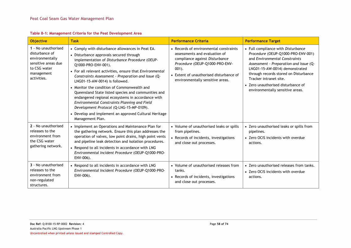
Peat Coal Seam Gas Water Management Plan
Doc Ref: Q-8100-15-RP-0002 Revision: 4 Page 58 of 74
Australia Pacific LNG Upstream Phase 1
Uncontrolled when printed unless issued and stamped Controlled Copy.
Table 8-1: Management Criteria for the Peat Development Area
Objective Task Performance Criteria Performance Target
1 - No unauthorised
disturbance of
environmentally
sensitive areas due
to CSG water
management
activities.
Comply with disturbance allowances in Peat EA.
Disturbance approvals secured through
implementation of Disturbance Procedure (OEUP-
Q1000-PRO-ENV-001).
For all relevant activities, ensure that Environmental
Constraints Assessment - Preparation and Issue (Q-
LNG01-15-AW-0014) is followed.
Monitor the condition of Commonwealth and
Queensland State listed species and communities and
endangered regional ecosystems in accordance with
Environmental Constraints Planning and Field
Development Protocol (Q-LNG-15-MP-0109).
Develop and implement an approved Cultural Heritage
Management Plan.
Records of environmental constraints
assessments and evaluation of
compliance against Disturbance
Procedure (OEUP-Q1000-PRO-ENV-
001).
Extent of unauthorised disturbance of
environmentally sensitive areas.
Full compliance with Disturbance
Procedure (OEUP-Q1000-PRO-ENV-001)
and Environmental Constraints
Assessment - Preparation and Issue (Q-
LNG01-15-AW-0014) demonstrated
through records stored on Disturbance
Tracker intranet site.
Zero unauthorised disturbance of
environmentally sensitive areas.
2 - No unauthorised
releases to the
environment from
the CSG water
gathering network.
Implement an Operations and Maintenance Plan for
the gathering network. Ensure this plan addresses the
operation of valves, low point drains, high point vents
and pipeline leak detection and isolation procedures.
Respond to all incidents in accordance with LNG
Environmental Incident Procedure (OEUP-Q1000-PRO-
ENV-006).
Volume of unauthorised leaks or spills
from pipelines.
Records of incidents, investigations
and close out processes.
Zero unauthorised leaks or spills from
pipelines.
Zero OCIS incidents with overdue
actions.
3 - No unauthorised
releases to the
environment from
non-regulated
structures.
Respond to all incidents in accordance with LNG
Environmental Incident Procedure (OEUP-Q1000-PRO-
ENV-006).
Volume of unauthorised releases from
tanks.
Records of incidents, investigations
and close out processes.
Zero unauthorised releases from tanks.
Zero OCIS incidents with overdue
actions.

Peat Coal Seam Gas Water Management Plan
Doc Ref: Q-8100-15-RP-0002 Revision: 4 Page 59 of 74
Australia Pacific LNG Upstream Phase 1
Uncontrolled when printed unless issued and stamped Controlled Copy.
Objective Task Performance Criteria Performance Target
4 - No unauthorised
releases to the
environment from
regulated structures.
Maintain register of regulated structures.
Develop and implement a Groundwater Monitoring
Plan to identify potential seepage from ponds.
Implement monitoring program as outlined in the Dam
and Pond Inspection Guide (OEUP-INT1000-GDL-ENG-
021).
Respond to all incidents in accordance with LNG
Environmental Incident Procedure (OEUP-Q1000-PRO-
ENV-006).
Volume of unauthorised releases from
regulated structures.
Change in groundwater quality.
Records demonstrating compliance
with implementation of Dam and Pond
Inspection Guide (OEUP-INT1000-GDL-
ENG-021).
Records of incidents, investigations
and close out processes.
Zero unauthorised releases from
regulated structures.
No exceedance of trigger value
specified in relevant Groundwater
Monitoring Plan attributable to
management of regulated structures.
Records of compliance with Dam and
Pond Inspection Guide (OEUP-INT1000-
GDL-ENG-021).
Zero OCIS incidents with overdue
actions.
5 - Take all
reasonable steps to
evaluate and, where
appropriate,
implement means to
optimise CSG water
management.
Develop and maintain a numerical reservoir model to
predict the quantity of CSG water production over the
life of the development area.
Continue to investigate opportunities to improve CSG
water management and prioritise options in
accordance with the CSG Water Management Policy
(DEHP 2012a).
Evidence that performance of CSG
water management system is
continually assessed and that, where
required, alternative means to
optimise the system are investigated.
Report on the outcomes of
investigations to optimise CSG water
management activities in each Peat EA
annual return.
6 - Supply CSG water
to beneficial uses in
accordance with
Peat EA or relevant
BUA.
Ensure Peat EA or BUA requirements for use in
question are met.
Develop and implement Water Quality Monitoring
Program to demonstrate that water quality is fit for
use, where water quality limits are stipulated.
Respond to all incidents in accordance with LNG
Environmental Incident Procedure (OEUP-Q1000-PRO-
ENV-006).
Water supplied and used in
accordance with Peat EA or relevant
BUA conditions.
Monitoring programs developed to
effectively monitor potential impacts
to EVs from beneficial uses.
Records of incidents, investigations
and close-out processes.
No non-compliance with Peat EA or
relevant BUA conditions for beneficial
uses.
Water Quality Monitoring program
implemented by commencement of
beneficial use activities.
Zero OCIS incidents with overdue
actions.

Peat Coal Seam Gas Water Management Plan
Doc Ref: Q-8100-15-RP-0002 Revision: 4 Page 60 of 74
Australia Pacific LNG Upstream Phase 1
Uncontrolled when printed unless issued and stamped Controlled Copy.
9. Monitoring
This chapter of the CWMP describes the monitoring that will be undertaken in the Peat development
area to enable the prediction and early detection of potential impacts to EVs from CSG water
management.
In addition to the groundwater and storage pond monitoring described below, closed tank(s) will be
regularly inspected by field operators to manage levels and to ensure an appropriate trucking frequency.
9.1. Integrity of CSG Water Storage Ponds
Australia Pacific LNG implements a range of inspection and monitoring procedures, summarised in Table
9-1, in order to ensure the continued safety and structural integrity of its CSG water storage ponds.
Table 9-1: CSG Water Storage Pond Monitoring Requirements
Activity Frequency Reporting Responsibility Procedure
Monitoring requirements
Embankments At least annually or
as required by the
Dam Inspection
Schedule (A-1000-20-
PS-001)
Any detectable movement
recorded as an incident in
OCIS and reported in
accordance with Peat EA
Qualified surveyors Asset Integrity
Management Plan for
Dams (Q1000-PLN-
ENG-002)
Pond water level Half yearly For inclusion in annual
return
Operations staff Dam and Pond
Inspection Guide
(OEUP-INT1000-GDL-
ENG-021)
Inspection requirements
Compliance
inspection
Annually Inspection report to be
submitted to Queensland
Government in
accordance with Peat EA
Registered
Professional Engineer
of Queensland
Procedure for
Conducting Annual and
Comprehensive Dam
Inspections (A-1000-
20-AP-001)
Embankments
(cracking,
erosion, seepage,
subsidence and
settlement, liner
damage)
Monthly or following
significant rainfall
For inclusion in annual
inspection report
Operations staff Dam and Pond
Inspection Guide
(OEUP-INT1000-GDL-
ENG-021)
Documentation Requirements
Register of
regulated
structures
Maintain existing
records
For inclusion in annual
return
Operations staff In accordance with
Peat EA
9.2. Groundwater
Groundwater monitoring in the Peat development area is targeted at the identification of potential
seepage from CSG water storage facilities. The groundwater monitoring program therefore includes two
(2) components, as outlined in the Peat Produced Water Storage Facility Groundwater Monitoring Plan
(OEUP-Q8100-PLN-ENV-002):
1. Monitoring of shallow groundwater at bores located around CSG water storage facilities; and
2. Monitoring of stored water quality.

Peat Coal Seam Gas Water Management Plan
Doc Ref: Q-8100-15-RP-0002 Revision: 4 Page 61 of 74
Australia Pacific LNG Upstream Phase 1
Uncontrolled when printed unless issued and stamped Controlled Copy.
The Peat Produced Water Storage Facility Groundwater Monitoring Plan (OEUP-Q8100-PLN-ENV-002) lists
the parameters to be monitored in groundwater and stored water in ponds as well as monitoring
locations and the procedures to be followed during sample collection and analysis. The monitoring
program has been developed to meet the requirements of:
Schedule C of the Peat EA;
The DEHP Monitoring and Sampling Manual 2009;
Geoscience Australia (2009) Groundwater Sampling and Analysis - A Field Guide;
AS/NZS 5667 11 2009 Water Sampling Guidelines - Part 11 Guidance on sampling
groundwater; and
National Environmental Protection (Assessment of Site Contamination) Measures (Australian
Government 1999).
Groundwater parameters will be monitored biannually with the exception of standing water level which
will be monitored quarterly. Stored water samples will be taken annually with parameters mirroring
those for groundwater.
The interpretation and assessment of results shall be performed by a suitably qualified professional, and
shall be compared to trigger values. If a trigger value is exceeded, a phased investigation will be
implemented in accordance with the Peat Produced Water Storage Facility Groundwater Monitoring Plan
(OEUP-Q8100-PLN-ENV-002) and the LNG Environmental Incident Procedure (OEUP-Q1000-PRO-ENV-006).
9.3. CSG Water Use
All uses of CSG water will comply with relevant approvals, including the collection, analysis and
reporting of data where required.
Wherever practicable, Australia Pacific LNG will use CSG water for dust suppression and construction
activities. The Peat EA currently specifies requirements for the use of CSG water for these activities
including water quality monitoring obligations (see Table 9-2). In addition, the use of CSG water for dust
suppression and/or construction must be carried out in such a way as to ensure that:
Vegetation is not damaged;
Soil erosion and soil structure damage is avoided;
The quality of groundwater is not adversely affected;
There is no water runoff from the nominated discharge areas;
There is no surface ponding or CSG water; and
There are no releases of CSG water to any surface waters
Approval of the use of CSG water for dust suppression and construction activities is currently authorised
by the Peat EA but in future, may be transitioned to the General BUA (DEHP 2014a). Any transition will
be described in an update to this CWMP, and implemented in accordance with approval processes.
Table 9-2: Peat EA Water Quality Limits for Dust Suppression and Construction Activities
Parameter Unit Limit Limit Type
pH - 6 - 9 Range
Total dissolved solids mg/L 2,000 Maximum
Total petroleum hydrocarbons mg/L 10 Maximum
9.4. Decommissioning and Remediation
Decommissioning and remediation of Pond 12 Cell 1, Pond 12 Cell 2, Pond 32 and GPF Pond 1 will be
undertaken in accordance with the TEP to be submitted to DEHP in 2015.

Peat Coal Seam Gas Water Management Plan
Doc Ref: Q-8100-15-RP-0002 Revision: 4 Page 62 of 74
Australia Pacific LNG Upstream Phase 1
Uncontrolled when printed unless issued and stamped Controlled Copy.
10. Management Systems and Records
The following chapter describes the key management systems through which this CWMP will be implemented.
10.1. Health, Safety and Environment Management System
Australia Pacific LNG operates under a health, safety and environment (HSE) policy and an established
Health, Safety and Environment Management System (HSEMS) developed with reference to
Australian/New Zealand Standard ISO 14001 - Environmental Management Systems and AS 4801 -
Occupational Health and Safety Management Systems. The HSEMS is implemented through a continuous
improvement cycle of Commit Plan Do Check Review. Each element of the cycle is executed
through a set of standards and directives, all of which support the HSE policy.
10.2. Project Delivery Process
The project delivery process (PDP) represents a structured and transparent project management process
with the aim of:
Identifying and assessing alternative options;
Selecting and developing the highest performing option/s;
Effectively implementing and executing the project; and
Providing reliable operation of all assets.
Whilst the PDP mandates the completion of specific activities, the means of achieving these
requirements are flexible to site-specific factors. The PDP has the following characteristics:
It addresses the full lifecycle of the project with each project progressing through a series of
controlled phases that include a formal decision review at the end of each phase;
Projects only progress through a decision gate after detailed scrutiny of their risks, assurance
having been provided that these risks can be effectively managed;
Controlled delivery is assured by having the need to meet defined objectives and targets
agreed early with the project manager and key stakeholders;
The organisational structure supports the delivery of projects via a sufficiently multi-
functional resource base throughout its lifecycle; and
Continuous improvement and performance measurement are built in to each PDP phase.
10.2.1. Environmental Data Management System
ESdat, an environmental data management system, has been selected by Australia Pacific LNG as the
internal database for the storage of all laboratory-derived water quality data. ESdat allows for the
management of data, supports trend analysis and provides a systematic approach to record keeping in
order to ensure ongoing data integrity. All ESdat records will be retained for no less than 5 years.
10.2.2. Exploration and Production Operations Management System
The Exploration and Production Operations Management System (EPOMS) provides the framework for
storing, accessing and using documentation applicable to the operation of infrastructure in the Peat
development area, including the CSG water management system.
10.2.3. Enterprise Asset Management System
Australia Pacific LNG has developed a register to capture all CSG operational assets. This data is stored
in the Enterprise Asset Management System (EAMS) and is used to schedule routine tasks against
particular assets. EAMS also tracks actions with respect to scheduled and reactive asset maintenance.

Peat Coal Seam Gas Water Management Plan
Doc Ref: Q-8100-15-RP-0002 Revision: 4 Page 63 of 74
Australia Pacific LNG Upstream Phase 1
Uncontrolled when printed unless issued and stamped Controlled Copy.
10.2.4. Origin Collective Intelligence System
Factual and accurate accounts of all incidents are recorded in OCIS, an incident and risk management
database. OCIS provides a common platform for reporting incidents, observations, risks and any relevant
or stand-alone actions. It is used to track incident investigation, reporting requirements and
preventative and/or corrective actions. As the investigation and associated actions are completed, the
incident can be reviewed and closed out. Incident reports are stored in OCIS for no less than the life of
the project or activity.
10.2.5. ATLAS Compliance Reporting and Recording System
ATLAS is an integrated environmental, social and regulatory compliance system that provides Australia
Pacific LNG with the capacity to record:
Regulatory compliance conditions and environmental and social commitments;
Required actions with due dates and assigned actions to defined users; and
Evidence of compliance.
ATLAS is used to record and track compliance against all EA conditions.
10.3. Risk Registers
For each operational site, a register documenting reasonably expected environmental risks is
maintained. Each risk register is reviewed annually and updated to reflect any changes in operating
philosophy.
Populated risk registers are uploaded to OCIS along with any actions for tracking. Completion of actions
under an agreed treatment plan will prompt a review of the risk register.
10.4. Roles and Responsibilities
The development, implementation and continual improvement of this CWMP is reliant on an effective
communication program. Personnel responsible for the implementation of this CWMP are identified in
Appendix B.
As part of the HSEMS, Australia Pacific LNG has developed company-wide systems and processes which
identify relevant stakeholders, staff and contractors and the required training and competencies
necessary to undertake their job roles. The communication of this CWMP applies to all staff involved in
CSG water management in the Peat development area and is delivered in a face-to-face environment
using the Australia Pacific LNG training and competency systems. Personnel are deemed to be a
Competent Person after completing the required combination of theoretical and practical training,
education and experience modules and after having been assessed by Competence Assessors. A training
and competency register is maintained for the life of the project.

Peat Coal Seam Gas Water Management Plan
Doc Ref: Q-8100-15-RP-0002 Revision: 4 Page 64 of 74
Australia Pacific LNG Upstream Phase 1
Uncontrolled when printed unless issued and stamped Controlled Copy.
11. Response and Reporting
11.1. Routine
An annual return will be submitted to DEHP to demonstrate how relevant Peat EA conditions have been
met for the preceding year. This will include a review of performance against the management criteria
presented in Section 8. In addition, other routine reporting associated with this CWMP will include:
An annual monitoring report in accordance with Condition (P5) of the Peat EA to be compiled
and presented to DEHP upon request; and
An annual monitoring and compliance report in accordance with Condition (D10) of the Peat
EA to be submitted to DEHP with the annual return and on request.
This CWMP is also subject to periodic review and update, with audit reports and actions stored and
tracked through OCIS. Audit records will be kept for no less than five (5) years and in accordance with
the relevant regulatory and legislative requirements.
11.2. Non-routine
The Peat development area operates under two (2) key Australia Pacific LNG directives; the Crisis and Emergency Management Directive (ORG-HSE-DVE-003) and the Incident Management Directive (ORG-HSE-DVE-006).
The Crisis and Emergency Management Directive (ORG-HSE-DVE-003) defines requirements for the effective response to a crisis and emergency situation in order to minimise the impacts on people, environment, plant and/or property. The emergency response framework contains three (3) tiers based on the severity of the potential impact:
Serious – managed under a site emergency response plan;
Critical or Major – managed under a group emergency management plan; and
Catastrophic – managed under a crisis management plan.
A site-specific Emergency Response Plan: Peat Gas Plant and Field (OEUP-Q8100-PLN-SAF-002) outlines specific emergency responses for the Peat development area including those related to environmental incidents.
The Incident Management Directive (ORG-HSE-DVE-006) details the internally-specified mandatory response, notification, recording, investigation, corrective and preventative actions, review, and analysis and reporting requirements for all incidents. There are six (6) stages in the incident management process as follows:
Stage 1 – Response and notification;
Stage 2 – Incident recording;
Stage 3 – Incident investigation;
Stage 4 – Corrective and preventive actions;
Stage 5 – Incident sign-off; and
Stage 6 – Review, analysis and reporting.
All incidents in the Peat development area are responded to in accordance with the LNG Environmental
Incident Procedure (OEUP-Q1000-PRO-ENV-006). All incident response processes are recorded and closed
out through OCIS with incident reports stored for no less than the life of the project.
All monitoring results will be reviewed regularly and on an ongoing basis. Non-compliance or exceedance
of conditions in the Peat EA will be reported within the required timeframe to the appropriate authority.

Peat Coal Seam Gas Water Management Plan
Doc Ref: Q-8100-15-RP-0002 Revision: 4 Page 65 of 74
Australia Pacific LNG Upstream Phase 1
Uncontrolled when printed unless issued and stamped Controlled Copy.
12. Review and Update of the CSG Water Management Strategy
Australia Pacific LNG is committed to regularly revisiting its CSG water management strategies in order
to:
Evaluate whether the strategies remain capable of managing the total volumes of CSG water
expected to be produced over the lifetime of the development area;
Identify whether the implemented options of managing CSG water can be optimised; and
Establish whether new or alternative CSG water management options are required and if so,
whether or not they are feasible.
Review and update of the Peat CWMP will be undertaken once every three (3) years and in accordance
with Condition (D8) of the Peat EA and will include consideration of:
Current strategies;
Best practice alternatives;
Advances in new technology;
Standards and practices in relation to the management of CSG water;
New beneficial use proposals; and
Management of waste streams.
An update to the CWMP may also be triggered by:
Any appropriate and relevant recommendations from the Peat EA annual return;
Failure to meet the management criteria outlined in Section 8;
Any significant change to the predicted CSG water production profile;
Any significant change to the understanding of CSG water quality;
Implementation of a new management practice not already addressed by the CWMP
(including additional beneficial uses of CSG water);
Any appropriate and relevant recommendations resulting from an incident investigation;
Any appropriate and relevant recommendations resulting from review of monitoring
results/data;
A request by the administering authority; and
Any significant change to relevant legislation and/or government policy.
Any changes to the Peat CWMP will be made in consultation with DEHP and relevant key stakeholders.
This framework for review and update is based on the continuous improvement methodology of Plan
Develop Evaluate Implement Monitor. In applying the continuous improvement cycle to this
CWMP, evaluation of performance against the management criteria outlined Section 8 acts as the key
metric for success.

Peat Coal Seam Gas Water Management Plan
Doc Ref: Q-8100-15-RP-0002 Revision: 4 Page 66 of 74
Australia Pacific LNG Upstream Phase 1
Uncontrolled when printed unless issued and stamped Controlled Copy.
13. References
AECOM, 2014. Environmental Site Assessment Report: Peat 12, Peat 32 and Peat GPF Dams, AECOM,
Australia.
ANZECC & ARMCANZ, 2000. Australian and New Zealand Guidelines for Fresh and Marine Water Quality,
ANZECC & ARMCANZ, Australia and New Zealand.
Acqua Della Vita Pty Ltd, 2014. Condamine River – DTA of boron and treated CSG water, Australia Pacific
LNG, Australia.
Australian Government, 2015. National Greenhouse and Energy Reporting [Online]. Available:
http://www.cleanenergyregulator.gov.au/National-Greenhouse-and-Energy-
Reporting/Pages/default.aspx, Accessed: 30 March 2015.
Australian Government, 1999. National Environmental Protection (Assessment of Site Contamination)
Measures, Australian Government, Canberra.
Australia Pacific LNG, 2010. Australia Pacific LNG Project Environmental Impact Statement, Australia
Pacific LNG, Australia.
Cockatoo Coal Ltd, 2012. North Surat – Taroom Project: initial advice statement, Cockatoo Coal Ltd.,
Australia.
Commonwealth of Australia, 1999. Environment Protection and Biodiversity Conservation Act.
Geoscience Australia, 2009. Groundwater Sampling and Analysis - A Field Guide, Australian Government,
Canberra.
Halcrow Pacific Pty Limited, 2012. Dawson River Release Scheme Direct Toxicity Assessment, Santos
GLNG Project, Australia.
National Health and Medical Research Council and Natural Resource Management Ministerial Council,
2011. Australian Drinking Water Guidelines, Australian Government, Canberra.
Northern Energy Corporation Limited, 2012. Elimatta Project: Environmental Impact Statement.
Northern Energy Corporation, Australia.
Natural Resource Management Ministerial Council, 2009. Australian Guidelines for Water Recycling:
Managed Aquifer Recharge, NRMMC, Australia.
National Uniform Drillers Licensing Committee, 2012. Minimum Construction Requirements for Water
Bores in Australia, National Uniform Drillers Licensing Committee, Australia.
Queensland Government Department of Environment and Heritage Protection, 2014a. General Beneficial
Use Approval Associated Water (including coal seam gas water), DEHP, Brisbane.
Queensland Government Department of Environment and Heritage Protection, 2014b. General Beneficial
Use Approval Irrigation of Associated Water (including coal seam gas water), DEHP, Brisbane.
Queensland Government Department of Environment and Heritage Protection, 2013a. Environmental
Protection Act 1994 Guideline: Application requirements for petroleum activities, DEHP, Brisbane.
Queensland Government Department of Environment and Heritage Protection, 2013b. Manual for
Assessing Consequence Categories and Hydraulic Performance of Structures, DEHP, Brisbane.
Queensland Government Department of Environment and Heritage Protection, 2012a. CSG Water
Management Policy, DEHP, Brisbane.
Queensland Government Department of Environment and Heritage Protection, 2012b. Manual for
Assessing Hazard Categories and Hydraulic Performance of Dams, DEHP, Brisbane.
Queensland Government Department of Environment and Heritage Protection, 2011. Environmental
Protection (Water) Policy 2009 – Dawson River Sub-basin Environmental Values and Water Quality
Objectives: Basin No. 130 (part), including all waters of the Dawson River Sub-Basin except the Callide
Creek Catchment, DEHP, Brisbane.
Queensland Government Department of Environment and Heritage Protection, 2009. Monitoring and
Sampling Manual, DEHP, Brisbane.
Queensland Government Department of Natural Resources and Mines, 2014. Minimum Standards for the
Construction and Reconditioning of Water Bores That Intersect the Sediments of Artesian Basins in
Queensland, DNRM, Brisbane.
Peat Coal Seam Gas Water Management Plan
Doc Ref: Q-8100-15-RP-0002 Revision: 4 Page 67 of 74
Australia Pacific LNG Upstream Phase 1
Uncontrolled when printed unless issued and stamped Controlled Copy.
Queensland Government Department of Natural Resources and Mines, 2013. Code of Practice for
Constructing and Abandoning Coal Seam Gas Wells and Associated Bores in Queensland, DNRM, Brisbane.
Queensland Government Department of Natural Resources and Mines, 2012. Great Artesian Basin
Resource Operations Plan, DNRM, Brisbane.
SMEC, 2014. Annual Dam Inspection, SMEC, Australia.
Stanmore Coal, 2011. The Range Project – Initial Advice Statement. Stanmore Coal, Australia.
State of Queensland, 2011. Waste Reduction and Recycling Act.
State of Queensland, 2009. Environmental Protection (Water) Policy.
State of Queensland, 1994. Environmental Protection Act.
State of Queensland, 1992. Nature Conservation Act.
State of Queensland, 1971. State Development and Public Works Organisation Act.
SunWater, 2015. Woleebee Creek-Glebe Weir – Overview [Online]. Available:
http://www.sunwater.com.au/future-developments/woleebee-creek-glebe-weir/overview. Accessed: 30
March 2015.
Xstrata Coal, 2012. Wandoan Project: Fact Sheet – water management. Xstrata Coal, Australia.
Xstrata Coal, 2009. Wandoan Coal Project: Supplementary Environmental Impact Statement. Xstrata
Coal, Australia.
Peat Coal Seam Gas Water Management Plan
Doc Ref: Q-8100-15-RP-0002 Revision: 4 Page 68 of 74
Australia Pacific LNG Upstream Phase 1
Uncontrolled when printed unless issued and stamped Controlled Copy.
Appendix A - Assessment of Risks to Environmental Values

Peat Coal Seam Gas Water Management Plan
Doc Ref: Q-8100-15-RP-0002 Revision: 4 Page 69 of 74
Australia Pacific LNG Upstream Phase 1
Uncontrolled when printed unless issued and stamped Controlled Copy.

Peat Coal Seam Gas Water Management Plan
Doc Ref: Q-8100-15-RP-0002 Revision: 4 Page 70 of 74
Australia Pacific LNG Upstream Phase 1
Uncontrolled when printed unless issued and stamped Controlled Copy.

Peat Coal Seam Gas Water Management Plan
Doc Ref: Q-8100-15-RP-0002 Revision: 4 Page 71 of 74
Australia Pacific LNG Upstream Phase 1
Uncontrolled when printed unless issued and stamped Controlled Copy.

Peat Coal Seam Gas Water Management Plan
Doc Ref: Q-8100-15-RP-0002 Revision: 4 Page 72 of 74
Australia Pacific LNG Upstream Phase 1
Uncontrolled when printed unless issued and stamped Controlled Copy.

Peat Coal Seam Gas Water Management Plan
Doc Ref: Q-8100-15-RP-0002 Revision: 4 Page 73 of 74
Australia Pacific LNG Upstream Phase 1
Uncontrolled when printed unless issued and stamped Controlled Copy.
Appendix B - Responsibilities for CSG Water Management
Role Responsibility
Supervisor - Peat Conducts on-site inductions, toolbox talks and training as required.
Ensures day-to-day activities comply with the requirements of the Peat EA, other
applicable regulatory approvals and the CWMP.
Supervisors on-site water quality and quantity monitoring as required.
Notifies Superintendent – Talinga/Orana of any incidents that have the potential to cause
environmental harm.
Ensures all environmental incidents and hazards are recorded in accordance with
relevant Australia Pacific LNG procedures.
Complies with all relevant occupational health, safety and environmental legislation,
codes of practice, standards, policies, operating procedures and work instructions.
Is actively involved in developing, reviewing and auditing the CWMP and procedures.
Superintendent –
Talinga/Orana
Overall responsibility for ensuring CSG water management is conducted in accordance
with Peat EA.
Ensures appropriate communication with stakeholders to ensure they are informed of
issues and developments that may affect their day-to-day activities.
Ensures all environmental incidents and hazards are recorded in accordance with
relevant Australia Pacific LNG procedures.
Complies with all relevant legislations, codes of practice, standards, policies, operating
procedures and work instructions.
Production Chemist Provides technical advice and assistance for water quality monitoring required by Peat
EA and CWMP.
Provides technical advice and assistance to ensure all monitoring is undertaken by
suitably qualified and competent personnel in accordance with regulatory / legislative
requirements.
Reviews verification monitoring laboratory results upon delivery and uploads these to
ESdat.
Ensures non-compliances are escalated in accordance with Australia Pacific LNG
procedures.
Asset Manager –
Talinga/Orana
Accountable for the development of specific operations and maintenance plans and
procedures in consultation with key stakeholders and project personnel to ensure
efficient operation of CSG water management infrastructure.
Initiates any required incident investigations, reviews investigation outcomes and ensures
mitigation actions are implemented.
Provides managerial support for the reviewing, reporting, auditing, monitoring and
training requirements of the CWMP.
Provides resources with respect to optimising operations to meet the objectives set out
in the CWMP.
Provides resources to support non compliance investigations.
Co-ordinates and schedules annual review of risk register.
Is actively involved in developing, reviewing and auditing health, safety and environment
systems and procedures.

Peat Coal Seam Gas Water Management Plan
Doc Ref: Q-8100-15-RP-0002 Revision: 4 Page 74 of 74
Australia Pacific LNG Upstream Phase 1
Uncontrolled when printed unless issued and stamped Controlled Copy.
Role Responsibility
Productions
Operations Group
Manager
Ensures appropriate resources are allocated to ensure that management of CSG water
complies with applicable Australia Pacific LNG policies, procedures and CWMP
requirements.
Ensures that the commitments of the CWMP are implemented and ensures monitoring,
recording and reporting are undertaken.
Ensures that appropriate communication systems are in place between Australia Pacific
LNG, contractors and other stakeholders that may affect their day-to-day activities.
Environmental
Approvals and
Strategy Manager
Liaises with regulatory authorities, key stakeholders and Australia Pacific LNG employees
and contractors with respect to environmental compliance matters.
Assists in strategic planning to rectify compliance issues should they occur.
Environmental
Compliance and
Performance
Manger
Co-ordinates and schedules audits of the CWMP.
Provides notification to regulatory authorities and key Australia Pacific LNG stakeholders
of incidents that may have caused or have the potential to cause environmental harm.
Ensures environmental non-compliances are reported in accordance with relevant
Australia Pacific LNG procedures and the Peat EA.
Project Manager -
Water Solutions
Oversees development of the project-specific CSG water management strategy in
consultation with regulatory authorities, key stakeholders and project personnel.
Provides technical assistance to the reviewing, reporting, auditing, monitoring and
training requirements of this CWMP.
Oversees and approves updates of the CWMP.
Oversees continuous improvement of CSG water management to optimise beneficial use.
Ensures adaptive management techniques are incorporated into water management
practice.
Facilitates technical advice and assistance for development and advancement of the
CWMP to stay abreast of relevant legislation.
Project Manager –
CSG Projects
Provision of engineering and construction management to ensure delivery of CSG water
management infrastructure.
Benchmarking and continual improvement of CSG water management infrastructure to
meet strategy and associated objectives outlined in CWMP.
Identifies hazards and risk associated with the operation and maintenance of CSG water
management infrastructure and develops, implements and monitors mitigation measures
accordingly.


![Seam - ####### [###20080327] - JBoss...Table of Contents JBoss Seam## .....xi 1. Seam ## .....1](https://img.pdfslide.net/doc/110x75/60d604b5fa8e121d9f6a07dc/seam-20080327-jboss-table-of-contents-jboss-seam-xi.jpg)