Embed Size (px)
Citation preview

Lawrence County/Perry Township Act 167
Stormwater Management Plan
Ordinance # 3-10-11
Adopted March 10, 2011
Effective March 13, 2011


ACT 167 STORMWATER MANAGEMENT ORDINANCE
ORDINANCE NO. 3-10-11
MUNICIPALITY of
PERRY TOWNSHIP
LAWRENCE COUNTY, PENNSYLVANIA
Adopted at a Public Meeting Held on
March 10, 2011

I
Article I- General Provisions
Section 101. Short Title Section 102. Statement of Findings Section 103. Purpose Section 104. Statutory Authority Section 105. Applicability Section 106. Repealer Section 107. Severability Section 108. Compatibility with Other Ordinance Requirements
Article II- Definitions Article III- Stormwater Management Standards
Section 301. General Requirements Section 302. Exemptions Section 303. Waivers Section 304. Volume Controls Section 305. Rate Controls Section 306. Calculation Methods Section 307. Other Requirements Section 308. Timber Harvesting/Silviculture
Article IV- SWM Site Plan and Report Requirements
Section 401. Plan and Report Contents Section 402. Plan Submission Section 403. Plan Review Section 404. Modification of Plans Section 405. Resubmission of Disapproved SWM Site Plans Section 406. Record Drawings and Final Inspection
Article V-Operation and Maintenance
Section 501. Responsibilities Section 502. Operation and Maintenance Agreements
Article VI-Fees and Expenses
Section 601. General
Article VII-Prohibitions
Section 701. Prohibited Discharges and Connections Section 702. Roof Drains Section 703. Alteration of BMPs

II
Article VIII-Enforcements and Penalties
Section 801. Right of entry Section 802. Inspection Section 803. Enforcement Section 804. Suspensions and Revocation Section 805. Penalties Section 806. Appeals
Article IX- References Appendix A: Low Impact Development Practices Appendix B: Site Conditions Suitable for Infiltration
BMPs for Infiltration BMPs for Rate Control BMPs for Evapotranspiration
Appendix C: Operation and Maintenance Agreement, Stormwater Best Management Practices Appendix D: Rational Formula Runoff Coefficients Appendix E: Small Project SWM Plan Application and Worksheets Attachment A: Additional Ordinance and Technical Guidelines Toolbox

1
ARTICLE I -GENERAL PROVISIONS
Section 101. Short Title
This Ordinance shall be known and may be cited as the “ Lawrence County-Perry Township 2011 Stormwater Management Ordinance.”
Section 102. Statement of Findings
The governing body of the Municipality finds that:
A. Inadequate management of accelerated runoff of Stormwater resulting from development throughout a watershed increases flows and velocities, contributes to erosion and sedimentation, overtaxes the carrying capacity of streams and storm sewers, greatly increases the cost of public facilities to carry and control Stormwater, undermines flood plain management and flood control efforts in downstream communities, reduces groundwater recharge, threatens public health and safety, and increases non-point source pollution of water resources.
B. A comprehensive program of Stormwater management, including reasonable regulation of development and activities causing accelerated runoff, is fundamental to the public health, safety and welfare and the protection of people of the Commonwealth, their resources and the environment.
C. Stormwater is an important water resource, which provides groundwater recharge for water supplies and base flow of streams, which protects and maintains surface water quality.
D. Federal and state regulations require certain Municipalities to implement a program of Stormwater controls. These Municipalities are required to obtain a permit for Stormwater discharges from their separate storm sewer systems under the National Pollutant Discharge Elimination System (NPDES).
Section 103. Purpose
The purpose of this Ordinance is to promote health, safety, and welfare within the Municipality and its watershed by minimizing the harms and maximizing the benefits described in Section 102 of this Ordinance, through provisions designed to:
A. Meet legal water quality requirements under state law, including regulations at 25 Pa. Code Chapter 93 to protect, maintain, reclaim and restore the existing and designated uses.
B. Preserve the natural drainage systems as much as possible.

2
C. Manage Stormwater runoff close to the source.
D. Provide the minimum procedures and performance standards for Stormwater planning and management.
E. Maintain groundwater recharge, to prevent degradation of surface and groundwater quality and to otherwise protect water resources.
F. Prevent scour and erosion of stream banks and streambeds.
G. Provide proper operations and maintenance of all permanent Stormwater Management Best Management Practices (BMPs) implemented within the Municipality.
H. Provide standards to meet NPDES permit requirements.
Section 104. Statutory Authority
A. Primary Authority:
The Municipality is empowered to regulate these activities by the authority of the Act of October 4, 1978, P.L. 864 (Act 167), 32 P.S. Section 680.1, et seq., as amended, the “Stormwater Management Act” and the PL805#247.
B. Secondary Authority:
The Municipality is empowered to regulate land use activities that affect runoff by the authority of the Act of July 31, 1968, P.L. 805, No. 247, The Pennsylvania Municipalities Planning Code, as amended.
Section 105. Applicability
All Regulated Activities and all activities that may affect Stormwater runoff, including land development or earth disturbance, are subject to regulation by this Ordinance.
Section 106. Repealer
Any other ordinance provision(s) or regulation of the Municipality inconsistent with any of the provisions of this Ordinance is hereby repealed to the extent of the inconsistency only.
Section 107. Severability
In the event that a court of competent jurisdiction declares any section or provision of this Ordinance invalid, such decision shall not affect the validity of any of the remaining provisions of this Ordinance.

3
Section 108. Compatibility with Other Ordinance Requirements
Approvals issued and actions taken under this Ordinance do not relieve the Applicant of the responsibility to secure required permits or approvals for activities regulated by any other code, law, regulation or ordinance.

4
ARTICLE II –DEFINITIONS
For the purposes of this Ordinance, certain terms and words used herein shall be interpreted as follows:
A. Words used in the present tense include the future tense; the singular number includes the plural, and the plural number includes the singular; words of masculine gender include feminine gender; and words of feminine gender include masculine gender.
B. The word "includes" or "including" shall not limit the term to the specific example but is intended to extend its meaning to all other instances of like kind and character.
C. The words "shall" and "must" are mandatory; the words "may" and "should" are permissive.
D. The words “used or occupied” include the words “intended, designed, maintained, or arranged to be used or occupied.”
Accelerated Erosion - The removal of the surface of the land through the combined action of man's activity and the natural processes of a rate greater than would occur because of the natural process alone.
Agricultural Activity - The work of producing crops including tillage, land clearing, plowing, disking, harrowing, planting, harvesting crops, or pasturing and raising of livestock and installation of conservation measures. Construction of new buildings or impervious area is not considered an Agricultural Activity.
Alteration - As applied to land, a change in topography because of the moving of soil and rock from one location or position to another; also the changing of surface conditions by causing the surface to be more or less impervious; land disturbance.
Applicant - A landowner, developer or other person who has filed an application for approval to engage in any Regulated Earth Disturbance activity at a project site in the Municipality.
Bank full – The channel at the top-of-bank or point where water begins to overflow onto a floodplain.
Base Flow – Portion of stream discharge derived from groundwater; the sustained discharge that does not result from direct runoff or from water diversions, reservoir releases, piped discharges, or other human activities.
Bioretention – A Stormwater retention area that utilizes woody and herbaceous plants and soils to remove pollutants before infiltration occurs.
BMP (Best Management Practice) - Activities, facilities, designs, measures or procedures used to manage Stormwater impacts from Regulated Activities, to meet State Water Quality Requirements, to promote groundwater recharge and to otherwise meet the purposes of this Ordinance. BMPs include but are not limited to infiltration, filter strips, low impact design, bio-retention, wet ponds, permeable paving, grassed swales, forested buffers, sand filters and detention basins. Structural SWM BMPs are permanent appurtenances to the project site.
Carbonate Bedrock (Areas) - Rock consisting chiefly of carbonate minerals, such as limestone and dolomite; specifically a sedimentary rock composed of more than 50% by weight of carbonate minerals that underlies soil or other unconsolidated, superficial material.
5
Channel - A drainage element in which Stormwater flows with an open surface. Open channels include, but shall not be limited to, natural and man-made drainage ways, swales, streams, ditches, canals, and pipes flowing partly full.
Channel Erosion - The widening, deepening, and headward cutting of small channels and waterways, caused by Stormwater runoff or bank full flows.
Cistern - An underground reservoir or tank for storing rainwater.
Conservation District - A conservation district, as defined in section 3(c) of the Conservation District Law (3 P. S. § 851(c)), which has the authority under a delegation agreement executed with the Department to administer and enforce all or a portion of the erosion and sediment control program in this Commonwealth.
Culvert - A structure with appurtenant works, which carries water under or through an embankment or fill.
Dam - An artificial barrier, together with its appurtenant works, constructed for the purpose of impounding or storing water or another fluid or semi fluid, or a refuse bank, fill or structure for highway, railroad or other purposes which does or may impound water or another fluid or semi fluid.
Delineation - The process of determining a wetland’s physical boundaries.
Designee - The agent of the Lawrence County Planning Commission, Lawrence County Conservation District and/or agent of the governing body involved with the administration, review or enforcement of any provisions of this ordinance by contract or memorandum of understanding.
Design Storm - The magnitude and temporal distribution of precipitation from a storm event measured in probability of occurrence (e.g. a 5-year storm) and duration (e.g. 24-hours), used in the design and evaluation of Stormwater management systems. (See Return Period)
Detention - the volume of runoff that is captured and released into the Waters of this Commonwealth at a controlled rate.
Detention Basin - An impoundment designed to collect and attenuate Stormwater peak runoff by temporarily storing the runoff and releasing it at a predetermined rate. Detention basins are designed to drain completely shortly after any given rainfall event and are dry until the next rainfall event.
PA DEP - The Pennsylvania Department of Environmental Protection.
Development - See “Earth Disturbance Activity.” The term includes redevelopment.
Discharge – To release water from a project, site, aquifer, drainage basin or other point of interest (verb); The rate and volume of flow of water such as in a stream, generally expressed in cubic feet per second (volume per unit of time) (noun). See also Peak Discharge.
Discharge Point – The point to which Stormwater flows.
Disconnected Impervious Area (DIA) - An impervious or impermeable surface that is disconnected from any stormwater drainage or conveyance system and is redirected or directed to a pervious area, which allows for infiltration, filtration, and increased time of concentration as specified in Appendix G, Disconnected Impervious Area.
Disturbed Area – An un-stabilized land area where an earth disturbance activity is occurring or has occurred.
Ditch – (See Channel).
6
Down Slope Property Line - That portion of the property line of the lot, tract, or parcels of land being developed located such that overland or pipe flow from the site would flow towards it.
Drainage Easement - A right granted by a landowner to a grantee, allowing the use of private land for Stormwater management purposes.
Earth Disturbance Activity - A construction or other human activity which disturbs the surface of the land, including, but not limited to, clearing and grubbing, grading, excavations, embankments, road maintenance, building construction and the moving, depositing, stockpiling, or storing of soil, rock or earth materials.
Emergency Spillway – A conveyance area that is used to pass peak discharge greater than the maximum design storm controlled by a Stormwater Management facility.
Encroachment – A structure or activity that changes, expands, or diminishes the course, current or cross section of a watercourse, floodway, floodplain, or body of water.
Ephemeral stream – A stream with flowing water only during, and for a short duration after, precipitation events in a typical year. Ephemeral streambeds are located above the water table year-round. Groundwater is not a source of water for the stream. Runoff from rainfall is the primary source of water for stream flow.
Erosion - The natural process by which the surface of the land is worn away by water, wind or chemical action.
Erosion and Sediment Pollution Control Plan - A plan for a project site which identifies BMPs to minimize accelerated erosion and sedimentation.
Exceptional Value Waters – Surface waters of high quality which satisfy Pennsylvania Code Title 25 Environmental Protection, Chapter 93, Water Quality Standards, § 93.4b(b) (relating to anti-degradation).
Extended Detention Volume (EDV) - Release of detained runoff in excess of Permanently Removed Volume (PRV) over a period of time not less than 24 and not more than 72 hours.
Existing Condition – The dominant land cover during the five (5) year period immediately preceding a proposed Regulated Activity.
Felling - The process of cutting down standing trees.
Flood - A temporary condition of partial or complete inundation of land areas from the overflow of streams, rivers, and other waters of this Commonwealth.
Floodplain - Any land area susceptible to inundation by water from any natural source or delineated by applicable Federal Emergency Management Agency (FEMA) maps and studies as being a special flood hazard area. Also included are areas that comprise Group 13 Soils, as listed in Appendix A of the Pennsylvania Department of Environmental Protection (PA DEP) Technical Manual for Sewage Enforcement Officers (as amended or replaced from time to time by PA DEP).
Floodway - The channel of the watercourse and those portions of the adjoining floodplain that is reasonably required to carry and discharge the 100-year flood. Unless otherwise specified, the boundary of the floodway is as indicated on maps and flood insurance studies provided by FEMA. In an area where no FEMA maps or studies have defined the boundary of the 100-year floodway, the floodway includes floodplain areas within 50 feet of the top of each stream bank and the stream channel itself.
Forest Management / Timber Operations - Planning and activities necessary for the management of forestland. These include timber inventory and preparation of forest management plans, silvicultural

7
treatment, cutting budgets, logging road design and construction, timber harvesting, site preparation and reforestation.
Freeboard - A vertical distance between the elevation of the design high water elevation and the top of a dam, levee, tank, basin, swale, or diversion berm. The space is required as a safety margin in a pond or basin.
Grade - A slope, usually of a road, channel or natural ground specified in percent and shown on plans as specified herein. (To) Grade - to finish the surface of a roadbed, top of embankment or bottom of excavation.
Grassed Waterway - A natural or constructed waterway, usually broad and shallow, covered with erosion-resistant grasses, used to convey surface water.
Groundwater - Water beneath the earth's surface, often between saturated soil and rock that supplies wells and springs.
Groundwater Recharge - Replenishment of existing natural underground water supplies without degrading groundwater quality.
Harvesting - The felling, skidding, loading, and transporting of timber products.
High Quality Waters – Surface waters having quality which exceeds levels necessary to support propagation of fish, shellfish, and wildlife and recreation in and on the water by satisfying Pennsylvania Code Title 25 Environmental Protection, Chapter 93 Water Quality Standards, § 93.4b(a).
Hydric Soils - Soils that are characterized by the presence of water.
Hydrograph – A graph of stormwater or runoff discharge versus time for a selected point in the drainage system.
Hydrologic Soil Group (HSG) - Infiltration rates of soils vary widely and are affected by subsurface permeability as well as surface intake rates. Soils are classified into four HSG’s (A, B, C, and D) according to their minimum infiltration rate, which is obtained for bare soil after prolonged wetting. The Natural Resources Conservation Service (NRCS) of the US Department of Agriculture defines the four groups and provides a list of most of the soils in the United States and their group classification. The soils underlying the project site may be identified from a soil survey report that can be obtained from local NRCS offices or conservation district offices. Soils become less pervious as the HSG varies from A to D.
Hydrophytic Vegetation - Plant life that is adapted to living in wet conditions.
Impervious Surface (Impervious Area) - A surface that prevents the infiltration of water into the ground. Impervious surfaces (or covers) shall include, but not be limited to:
i. roofs, additional indoor living spaces, patios, garages, storage sheds and similar structures ii. new streets or sidewalks, decks, parking areas, and driveway areas using traditional paved
surfaces that prevent infiltration into the ground. New decks, parking areas, and driveways are not defined as impervious areas if they are designed to allow long-term infiltration.
iii. existing gravel parking areas, driveways, and roads shall be treated as slightly pervious and shall be analyzed using the appropriate SCS curve number based on their HSG; proposed gravel parking areas, driveways, and roads shall be treated as impervious areas for all calculations

8
Impoundment - A retention or detention basin designed to retain Stormwater runoff and release it at a controlled rate.
Infiltration – Movement of surface water into the soil, where it is absorbed by plant roots, evaporates into the atmosphere, or percolates downward to recharge groundwater.
Infiltration Structures - A structure designed to direct runoff into the groundwater (e.g., French drains, seepage pits, and seepage trench).
Inlet - The upstream end of any structure through which water may flow.
Intermittent Stream - A stream with flowing water during certain times of the year, when groundwater provides water for stream flow. During dry periods, intermittent streams may not have flowing water. Runoff from rainfall is a supplemental source of water for stream flow.
Karst – A type of topography or landscape characterized by surface depressions, sinkholes, rock pinnacles / uneven bedrock surface, underground drainage and caves. Karst is formed on carbonate rocks, such as limestone or dolomite.
Landing (or deck) - A place where logs or tree-length materials are assembled for loading and transport.
Land Development (Development) – any of the following activities:
(1) The improvement of one lot or two or more contiguous lots, tracts or parcels of land for any purpose involving: a group of two or more residential or nonresidential buildings, whether proposed initially or
cumulatively, or a single nonresidential building on a lot or lots regardless of the number of occupants or tenure; or
the division or allocation of land or space, whether initially or cumulatively, between or among two or more existing or prospective occupants by means of, or for the purpose of streets, common areas, leaseholds, condominiums, building groups or other features.
(2) A subdivision of land.
Litter Layer - The layer of fallen leaves, twigs, and decaying woody material that provides a sponge-like mat covering forest soils.
Lot - A part of a subdivision or a parcel of land used as a building site or intended to be used for building purposes, whether immediate or future, which would not be further subdivided.
Main Stem (Main Channel) - Any stream segment or other runoff conveyance facility used as a reach in the hydrologic model.
Manning Equation (Manning formula) - A method for calculation of velocity of flow (e.g., feet per second) and flow rate (e.g., cubic feet per second) in open channels based upon channel shape, roughness, depth of flow and slope. "Open channels" may include closed conduits so long as the flow is not under pressure.
Municipal Engineer – A professional engineer licensed as such in the Commonwealth of Pennsylvania, duly appointed as the engineer for a Municipality, planning agency or joint planning commission.
Municipality - Perry Township, Lawrence County, Pennsylvania.
Natural Recharge Area – Undisturbed surface area or depression where Stormwater collects, and a portion of which infiltrates and replenishes the underground and groundwater.

9
Non-point Source Pollution - Pollution that enters a water body from diffuse origins in the watershed and does not result from discernible, confined, or discrete conveyances.
Non-structural Best Management Practice (BMPs) – Methods of controlling Stormwater runoff quantity and quality, such as innovative site planning, impervious area and grading reduction, protection of natural depression areas, temporary ponding on site and other techniques.
NPDES - National Pollutant Discharge Elimination System, the federal government’s system for issuance of permits under the Clean Water Act, which is delegated to PA DEP in Pennsylvania.
NRCS - Natural Resources Conservation Service (previously SCS).
Outfall - “Point source” as described in 40 CFR § 122.2 at the point where the Municipality’s storm sewer system discharges to surface waters of the Commonwealth.
Outlet - Points of water disposal to a stream, river, lake, tidewater or artificial drain.
PA DOT - Pennsylvania Department of Transportation.
Parent Tract – The parcel of land from which a land development or subdivision originates, determined from the date of Municipal adoption of this ordinance.
Parking Lot Storage - The use of parking areas as temporary impoundments with controlled release rates during rainstorms.
Peak Discharge - The maximum rate of Stormwater runoff from a specific storm event.
Permanently Removed Volume (PRV) – The volume of runoff that is permanently removed from the runoff and not released into surface Waters of this Commonwealth during or after a storm event.
Pervious Surface (Pervious Area) – Any area or ground surface not defined as impervious and that may be vegetated or un-vegetated.
Pipe - A culvert, closed conduit, or similar structure (including appurtenances) that conveys Stormwater.
Planning Commission - The municipal or County planning commission authorized under the Pennsylvania Municipalities Planning Code.
Point Source - any discernible, confined and discrete conveyance, including, but not limited to, any pipe, ditch, channel, tunnel, or conduit from which Stormwater is or may be discharged, as defined in State regulations at 25 Pa. Code § 92.1.
Post-Construction – Period after construction where disturbed areas are stabilized, Stormwater controls are in place and functioning and all proposed improvements in the approved land development plan are completed.
Pre-development – Undeveloped/Natural Condition.
Pre-treatment – Techniques employed in Stormwater BMPs to provide storage or filtering to trap coarse materials and other pollutants before they enter the system.
Project Site - The specific area of land where any Regulated Activities in the Municipality are planned, conducted, or maintained.
Qualified Professional – A Professional Engineer licensed by the Pennsylvania Department of State or otherwise qualified by law to perform the engineering work required by the Ordinance.
Recharge – The replenishment of groundwater through the infiltration of rainfall or Stormwater runoff.
10
Record Drawings - Those drawings maintained by the Applicant, Applicant’s Contractor, or Applicant’s Agent as the Applicants project is constructed; and upon which is documented the actual locations of the building components and changes to the original contract documents. These, or a copy of same, are turned over to the Municipality at the completion of the project.
Redevelopment – The demolition, construction, reconstruction, alteration, or improvement exceeding 2,000 square feet of land disturbance performed on sites where existing land use is commercial, industrial, institutional, or multifamily residential. Maintenance activities such as top-layer grinding and re-paving are not considered redevelopment. Interior remodeling projects and tenant improvements are also not considered redevelopment. Utility trenches in streets are not considered redevelopment unless more than 50% of the street width is removed and re-paved.
Regulated Activities - All activities involving land development or earth disturbance activity that may affect stormwater runoff.
Regulated Earth Disturbance Activity - Activity involving Earth Disturbance subject to regulation under 25 PA Code Chapters 92, Chapter 102, or the Clean Streams Law.
Release Rate - The percentage of existing conditions peak rate of runoff from a site or subarea to which the post-development peak rate of runoff must be reduced to protect downstream areas.
Retention Basin - A structure in which Stormwater is stored and not released during the storm event. Retention Basins do not function without operational intervention to release stored Stormwater unless designed as infiltration-only basins.
Retention / Removed - The volume of runoff that is captured and not released directly into the surface Waters of this Commonwealth during or after a storm event.
Return Period - The interval, in years, within which a storm event of a given magnitude can be expected, on average, to recur. For example, the 25-year return period rainfall would be expected, on average, to recur every twenty-five years. The probability of a 25-year storm occurring in any one year is 0.04 or 4%
Riser - A vertical pipe extending from the bottom of a pond that is used to control the discharge rate from the pond for a specified design storm.
Road Maintenance - Earth disturbance activities within the existing road cross-section, such as grading and repairing existing unpaved road surfaces, cutting road banks, cleaning or clearing drainage ditches and other similar activities.
Roof Drains - A drainage conduit or pipe that collects water runoff from a roof and leads it away from the structure.
Rooftop Detention - Temporary ponding and gradual release of Stormwater falling directly onto flat roof surfaces by incorporating controlled-flow roof drains into building designs.
Runoff - Any part of precipitation that flows over the land.
SALDO – Subdivision and Land Development Ordinance.
SCS – Soil Conservation Service (currently known as NRCS, Natural Resources Conservation Service). Also a commonly referred to method (“SCS Method”) for the hydrologic computation and estimation of runoff from rainfall information that has been developed by the United States Department of Agriculture's Soil Conservation Service (SCS).
Sediment - Soils or other materials transported by surface water as a product of erosion.
11
Sediment Basin - A barrier, dam, retention or detention basin located and designed to retain rock, sand, gravel, silt, or other material transported by water during construction.
Sediment Pollution - The placement, discharge or any other introduction of sediment into the waters of the Commonwealth.
Sedimentation - The process by which mineral or organic matter is accumulated or deposited by the movement of water or air.
Seepage Pit/Seepage Trench - An area of excavated earth filled with loose stone or similar coarse material, into which surface water is directed for infiltration into the groundwater.
Separate Storm Sewer System - A conveyance or system of conveyances (including roads with drainage systems, Municipal streets, catch basins, curbs, gutters, ditches, man-made channels or storm drains) primarily used for collecting and conveying Stormwater runoff.
Shallow Concentrated Flow - Stormwater runoff flowing in shallow, defined rills prior to entering a defined channel or waterway.
Sheet Flow – A flow process associated with broad, shallow water movement on sloping ground surfaces that is not channelized or concentrated.
Skidding - Moving of logs or felled trees along the surface of the ground from the stump to the point of loading.
Skid Road/Haul Road – Those roads, trails, or other openings upon which trees, logs, equipment, or vehicles are moved within the site of the work.
Slash - Unusable woody material such as large limbs, tops, cull logs, and stumps that remain after timber harvesting.
Soil-Cover Complex Method - A method of runoff computation developed by the NRCS that is based on relating soil type and land use/cover to a runoff parameter called Curve Number (CN).
Special Geologic Features - Carbonate bedrock features, including but not limited to closed depressions, existing sinkholes, fracture traces, lineaments, joints, faults, caves and pinnacles, which may exist and must be identified on a site when Stormwater management BMPs are being considered.
Spillway – A conveyance that is used to pass the peak discharge of the maximum design storm controlled by the Stormwater facility.
State Water Quality Requirements - The regulatory requirements to protect, maintain, reclaim, and restore water quality under Pennsylvania Code Title 25 and the Clean Streams Law.
Storage Indication Method - A reservoir routing procedure based on solution of the continuity equation (inflow minus outflow equals the change in storage) with outflow defined as a function of storage volume and depth.
Storm Frequency - The number of times that a given storm "event" occurs or is exceeded on the average in a stated period of years. See "Return Period".
Storm Sewer - A system of pipes and/or open channels that convey intercepted runoff and Stormwater from other sources, but exclude domestic sewage and industrial wastes.
Stormwater - Drainage runoff from the surface of the land resulting from precipitation or snow or ice melt.

12
Stormwater Management Facility - Any structure, natural or man-made, that, due to its condition, design, or construction, conveys, stores, or otherwise affects Stormwater runoff. Typical Stormwater management facilities include, but are not limited to, detention and retention basins, open channels, storm sewers, pipes, and infiltration structures.
Stormwater Management Plan - The plan for managing Stormwater runoff adopted by the County of Lawrence as required by the Act of October 4, 1978, P.L. 864, (Act 167), as amended, and known as the “Stormwater Management Act”.
Stormwater Management BMPs - Is abbreviated as SWM BMPs throughout this Ordinance.
Stormwater Management Site Plan - The plan prepared by the Applicant or his representative indicating how Stormwater runoff will be managed at the project site in accordance with this Ordinance. Stormwater Management Site Plan will be designated as SWM Site Plan throughout this Ordinance.
Stream – A natural watercourse.
Stream Enclosure - A bridge, culvert or other structure in excess of 100 feet in length upstream to downstream that encloses a regulated water of this Commonwealth.
Subarea (Sub-watershed) - The smallest drainage unit of a watershed for which Stormwater management criteria have been established in the Stormwater Management Plan.
Subdivision - The division or re-division of a lot, tract or parcel of land by any means into two or more lots, tracts, parcels or other divisions of land including changes in existing lot lines for the purpose, whether immediate or future, of lease, partition by the court for distribution to heirs or devisees, transfer of ownership or building or lot development (Refer to the PA Municipalities Planning Code, current version.)
Surface Waters of the/this Commonwealth - Any and all rivers, streams, creeks, rivulets, ditches, watercourses, storm sewers, lakes, dammed water, wetlands, ponds, springs, and all other bodies or channels of conveyance of surface, or parts thereof, whether natural or artificial, within or on the boundaries of this Commonwealth.
Swale - A low-lying stretch of land that gathers or carries surface water runoff.
Timber Operations - See Forest Management.
Time-of-Concentration (Tc) - The time for surface runoff to travel from the hydraulically most distant point of the watershed to a point of interest within the watershed. This time is the combined total of overland flow time and flow time in pipes or channels, if any.
Top-of-Bank – Highest point of elevation in a stream channel cross section at which a rising water level just begins to flow out of the channel and over the floodplain.
USACE - United States Army Corp of Engineers
Vernal Pond – Seasonal depressional wetlands that are covered by shallow water for variable periods from winter to spring, but may be completely dry for most of the summer and fall.
Watercourse - A channel or conveyance of surface water having defined bed and banks, whether natural or artificial, with perennial or intermittent flow.
Waters of the/this Commonwealth - Rivers, streams, creeks, rivulets, impoundments, ditches, watercourses, storm sewers, lakes, dammed water, wetlands, ponds, springs and other bodies or channels of conveyance of surface and underground water, or parts thereof, whether natural or artificial, within or on the boundaries of this Commonwealth.

13
Watershed - Region or area drained by a river, watercourse or other body of water, whether natural or artificial.
Wet Basin – A detention basin that is designed to detain Stormwater and which always contains water.
Wetland - Those areas that are inundated or saturated by surface or ground water at a frequency and duration sufficient to support, and that under normal circumstances do support, a prevalence of vegetation typically adapted for life in saturated soil conditions, including swamps, marshes, bogs, fens, and similar areas.

14
ARTICLE III – STORMWATER MANAGEMENT STANDARDS
Section 301. General Requirements
A. Written approval of a SWM Site Plan must be issued by the Municipality prior to commencement of Regulated Activities unless exempt from this requirement under Section 302.
B. SWM Site Plans approved by the Municipality shall be on site throughout the duration of the Regulated Activity.
C. The Municipality may, after consultation with the PA DEP, approve measures for meeting the State Water Quality Requirements other than those in this Ordinance, provided they meet the minimum requirements of, and do not conflict with, State law including but not limited to the Clean Streams Law.
D. For all Regulated Activities, implementation of peak rate controls and preparation of a SWM Site Plan are required, unless exempted by Section 302 of this Ordinance
E. Impervious Areas: 1. The measurement of impervious areas shall include all of the impervious areas in the
total proposed development even if development is to take place in stages. 2. For development taking place in stages, the entire development plan must be used in
determining conformance with this Ordinance. 3. For projects that add impervious area to a parcel, the total impervious area on the
parcel is subject to the requirements of this ordinance, unless, the project is otherwise deemed exempt from stormwater management provisions per the criteria set forth in Section 302 of this plan.
4. Existing gravel parking areas, driveways, and roads shall not be considered impervious. These areas shall be treated as semi-pervious and shall be analyzed using the appropriate SCS curve number based on the appropriate HSG underlying the gravel areas, which is defined as:
a. HSG A – Gravel Area Curve Number shall be 76 b. HSG B – Gravel Area Curve Number shall be 85 c. HSG C – Gravel Area Curve Number shall be 89 d. HSG D – Gravel Area Curve Number shall be 91
5. Proposed gravel parking areas, driveways, and roads shall be considered impervious. F. Stormwater discharges onto adjacent property shall not be created, increased, decreased, or
relocated, or otherwise altered without [permission | written notification] of adjacent property owner(s). Such discharges shall be subject to the requirements of this Ordinance.
G. All regulated activities shall include such measures as necessary to: 1. Protect health, safety, and property; 2. Meet the water quality goals of this ordinance by implementing measures to:
a. Minimize disturbance to floodplains, wetlands, natural slopes over 15%, and existing native vegetation.
b. Minimize thermal impacts to Waters of the Commonwealth.

15
c. Preserve and maintain trees and woodlands. Maintain or extend riparian buffers and protect existing forested buffer. Provide trees and woodlands adjacent to impervious areas.
d. Establish and maintain non-erosive flow conditions in natural flow pathways. e. Minimize soil disturbance and soil compaction. Cover disturbed areas with
topsoil having a minimum depth of 4 inches. Use tracked equipment for grading.
f. Disconnect impervious surfaces by directing runoff to pervious areas. 3. Incorporate the techniques described in Appendix A of this Ordinance (Low Impact
Development Practices) whenever practical. H. The design of all facilities over Karst shall include an evaluation of measures to minimize
adverse effects. I. Infiltration BMPs shall be spread out, made as shallow as practicable, and located to maximize
use of natural on-site infiltration features while still meeting the other requirements of this Ordinance.
J. Storage facilities shall completely drain both the volume control and rate control capacities over a period of time not less than 24 and not more than 72 hours from the end of the design storm.
K. The design storm volumes to be used in the analysis of peak discharge rates shall be obtained from the Precipitation-Frequency Atlas of the United States, Atlas 14, Volume 2, US Department of Commerce, National Oceanic and Atmospheric Administration, National Weather Service, Hydrometeorological Design Studies Center, Silver Spring, Maryland, 20910. NOAA’s Atlas 14 can be accessed at Internet address:
http://hdsc.nws.noaa.gov/hdsc/pfds/.
L. The Municipality and its Engineer may require that regulated activities maintain a minimum distance between proposed impervious areas/stormwater management facility outlets and down slope property line(s).
M. SWM BMPs for all Regulated Activities shall be designed, implemented, operated, and maintained to meet the purposes and requirements of this Ordinance and to meet all requirements under Title 25 of the Pennsylvania Code, the Clean Streams Law, and the Stormwater Management Act.
N. For all regulated earth disturbance activities, erosion and sediment control BMPs shall be designed, implemented, operated, and maintained during the regulated earth disturbance activities (e.g., during construction) to meet the purposes and requirements of this Ordinance and to meet all requirements under Title 25 of the Pennsylvania Code and the Clean Streams Law. Various BMPs and their design standards are listed in the Erosion and Sediment Pollution Control Program Manual (E&S Manual), No. 363-2134-008 (April 15, 2000), as amended and updated.
Section 302. Exemptions
A. Under no circumstance shall the Applicant be exempt from implementing such measures as necessary to:
1. Meet special requirements for projects within High Quality (HQ) and Exceptional Value (EV) watersheds (Section 307.G).

16
B. The Applicant must demonstrate that the following BMPs are being used to the maximum extent practicable to receive consideration for the exemptions:
1. Design around and limit disturbance of Floodplains, Wetlands, Natural Slopes over 15%, existing native vegetation, and other sensitive and special value features.
2. Maintain riparian and forested buffers. 3. Limit grading and maintain non-erosive flow conditions in natural flow paths. 4. Maintain existing tree canopies near impervious areas. 5. Minimize soil disturbance and reclaim disturbed areas with topsoil and vegetation. 6. Direct runoff to pervious areas.
C. The Applicant must demonstrate that the proposed development/additional impervious area will not adversely impact the following:
1. Capacities of existing drainage ways and storm sewer systems. 2. Velocities and erosion. 3. Quality of runoff if direct discharge is proposed. 4. Existing known problem areas. 5. Safe conveyance of the additional runoff. 6. Downstream property owners.

17
D. An Applicant proposing Regulated Activities, after demonstrating compliance with Sections 302.A, 302.B, and 302.C, may be exempted from various requirements of this Ordinance according to the following table:
Table 302-1
0 SF ≤ new impervious area <1000 SF Required: Exempt from additional requirements
1000 SF ≤ new impervious area < 2500 SF Required: Small Project SWM Application1 (See Appendix F)
2500 SF ≤ new impervious area < 5000 SF Required: Volume Control (Section 304) and Small Project SWM Application (See Appendix F)
5000 SF ≤ new impervious area Required: Peak Rate Control (Section 305), Volume Control (Section 304), and Stormwater Management Site Plan
All Regulated Activities must comply with the State Water Quality Requirements.
E. New Single Family Residential activities on a single lot are exempt from the requirements of Section 304 - Volume Control, Section 305 - Peak Rate Control, and from the submission of a Small Project SWM Application provided the construction:
1. Complies with Sections 302.A, 302.B, 302.C, and 2. Has building setbacks of at least 75 feet from downslope property lines, and 3. Driveways:
a. Runoff must discharge onto pervious surface with a gravel strip or other spreading device.
b. No more than 1,000 square feet of paved surface may discharge to any one point.
c. For each discharge point, the flow length on the pervious surface must exceed the flow length on the paved surface flow."
F. The Municipality may accept alternative stormwater management controls under this section provided that:
1. The alternative controls are documented to be acceptable to PADEP (or Delegated Authority), for NPDES requirements pertaining to post construction stormwater management requirements.
2. The alternative controls comply with all other sections of this ordinance, including but not limited to Sections 301.C and 302.A-C.
1 The municipality can require the applicant to provide supplemental and additional information beyond the Small Project SWM Application if there is a threat to property, health or safety

18
G. Agricultural activities are exempt from the rate and SWM Site Plan preparation requirements of this ordinance provided the activities are performed according to the requirements of 25 Pa.Code Chapter 102.
H. Forest management and timber operations are exempt from the rate and volume control and SWM Site Plan preparation requirements of this ordinance provided the activities are performed according to the requirements of 25 Pa.Code Chapter 102. Refer to Section 308 for additional information and guidance concerning timber operations.
I. Exemptions from any provisions of this Ordinance shall not relieve the Applicant from the requirements in Sections 301. F, G, H, I, J and K.
J. Proposed Municipal projects are bound to the following requirements and criteria:
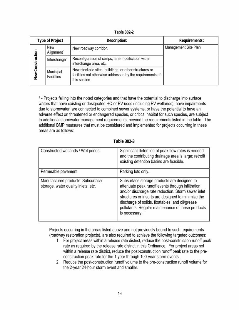
Table 302-2
Type of Project Description: Requirements:
Roa
dway
Res
tora
tion
Alignments*
Change the roadway by either reducing or eliminating horizontal and vertical curves, or changing the roadway’s superelevation.
Required: BMP implementation that uses non-structural and restoration practices such as:
Street sweeping
Impervious disconnection
Slope roughening
Pavement width reduction
Riparian buffers
Vegetative Restoration (including road side swales)
Pull-Offs* New, as part of a larger project or by itself.
Widening*
Increase the width of the existing travel lanes (no new lanes added) and shoulders, or extension of acceleration/deceleration ramps in existing shoulder areas.
Intersection* Nominal channelization of intersections and addition of turning lanes.
Required: Minor practices and BMP implementation that uses low-impact practices such as:
Preservation of existing vegetation
Minimization of soil compaction
Maintenance of Erosion Control and any PCSM BMPs
Restoration and stabilization of staging areas
Pavement Replace portions, overlay, or mill and resurface the roadway’s surface.
Shoulders Resurface, stabilize, upgrade (dirt or gravel to paved), or widen the existing shoulders within the existing footprint.
Other
Replace and/or repair guide rail, signs, traffic signals, and drainage systems to their original specifications; various minor safety improvements.
Major Widening*
Addition of one or more travel lanes, including acceleration and deceleration lanes, to an existing road.
Required: Peak Rate Control (Section 305), Volume Control (Section 304), and Stormwater
19
Table 302-2
Type of Project Description: Requirements: N
ew C
onst
ruct
ion
New Alignment*
New roadway corridor. Management Site Plan
Interchange* Reconfiguration of ramps, lane modification within interchange area, etc.
Municipal Facilities
New stockpile sites, buildings, or other structures or facilities not otherwise addressed by the requirements of this section
* - Projects falling into the noted categories and that have the potential to discharge into surface waters that have existing or designated HQ or EV uses (including EV wetlands), have impairments due to stormwater, are connected to combined sewer systems, or have the potential to have an adverse effect on threatened or endangered species, or critical habitat for such species, are subject to additional stormwater management requirements, beyond the requirements listed in the table. The additional BMP measures that must be considered and implemented for projects occurring in these areas are as follows:
Table 302-3
Constructed wetlands / Wet ponds Significant detention of peak flow rates is needed and the contributing drainage area is large; retrofit existing detention basins are feasible.
Permeable pavement Parking lots only.
Manufactured products: Subsurface storage, water quality inlets, etc.
Subsurface storage products are designed to attenuate peak runoff events through infiltration and/or discharge rate reduction. Storm sewer inlet structures or inserts are designed to minimize the discharge of solids, floatables, and oil/grease pollutants. Regular maintenance of these products is necessary.
Projects occurring in the areas listed above and not previously bound to such requirements (roadway restoration projects), are also required to achieve the following targeted outcomes:
1. For project areas within a release rate district, reduce the post-construction runoff peak rate as required by the release rate district in this Ordinance. For project areas not within a release rate district, reduce the post-construction runoff peak rate to the pre-construction peak rate for the 1-year through 100-year storm events.
2. Reduce the post-construction runoff volume to the pre-construction runoff volume for the 2-year 24-hour storm event and smaller.

20
Section 303. Waivers
A. The provisions of this Ordinance are the minimum standards for the protection of the public B. Waivers shall not be issued from implementing such measures as necessary to:
1. Meet State Water Quality Standards and Requirements. 2. Protect health, safety, and property. 3. Meet special requirements for High Quality (HQ) and Exceptional Value (EV)
watersheds. C. The Municipality will consider waiver requests in accordance with Section 301.C. If an
Applicant demonstrates to the satisfaction of the governing body of the Municipality that any mandatory provision of this Ordinance is unreasonable or causes unique or undue unreasonableness or hardship as it applies to the proposed Project, or that an alternate design may result in a superior result within the context of Section 102 and 103 of this Ordinance, the governing body of the Municipality upon obtaining the comments and recommendations of the Municipal Engineer and Conservation District may grant a waiver or relief so that substantial justice may be done and the public interest is secured; provided that such waiver will not have the effect of nullifying the intent and purpose of this Ordinance.
D. The Applicant shall submit all requests for waivers in writing and shall include such requests as a part of the plan review and approval process. The Applicant shall state in full the facts of unreasonableness or hardship on which the request is based, the provision or provisions of the Ordinance that are involved, and the minimum waiver or relief that is necessary. The Applicant shall state how the requested waiver and how the Applicant’s proposal shall result in an equal or better means of complying with the requirements of this Ordinance including but not limited to Section 301, General Requirements.
E. The Municipality shall keep a written record of all actions on waiver requests. The Municipality may charge a fee for each waiver request, which shall be used to offset the administrative costs of reviewing the waiver request. The Applicant shall also agree to reimburse the Municipality for reasonable and necessary fees that may be incurred by the Municipal Engineer in any review of a waiver request.
F. In granting waivers, the Municipality may impose reasonable conditions that will, in its judgment, secure substantially the objectives of the standards or requirements that are to be modified.
G. The Municipality may grant applications for waivers when the following findings are made, as relevant:
1. Requests must meet the provisions of Section 303.G and Section 303.H. 2. That the waiver shall result in an equal or better means of complying with the intent of
this Ordinance. 3. That the waiver is the minimum necessary to provide relief. 4. That the applicant is not requesting a waiver based on cost considerations. 5. That existing down gradient stormwater problems will not be exacerbated. 6. That runoff is not being diverted to a different drainage area. 7. That increased flooding or ponding on off-site properties or roadways will not occur. 8. That potential icing conditions will not occur. 9. That increases in peak flow or volume from the site will not occur. 10. That erosive conditions due to increased peak flows or volume will not occur. 11. That adverse impact to water quality will not result.

21
12. That increased 100-Year Floodplain levels will not result. 13. That increased or unusual municipal maintenance expenses will not result from the
waiver. 14. That the amount of stormwater generated has been minimized to the greatest extent
allowed. 15. That infiltration of runoff throughout the proposed site has been provided where
practicable and pre-development ground water recharge protected. 16. That peak flow attenuation of runoff has been provided. 17. That long-term operation and maintenance activities are established. 18. That the receiving streams and/or water bodies will not be adversely impacted in flood
carrying capacity, aquatic habitat, channel stability and erosion and sedimentation.
Section 304. Volume Controls
The low impact development practices provided in the PA BMP Manual shall be used for all regulated activities to the maximum extent practicable. Water volume controls shall be implemented using the Design Storm Method in Subsection A or the Simplified Method in Subsection B below. For regulated activity areas equal or less than 1 acre that do not require hydrologic routing to design the stormwater facilities, this Ordinance establishes no preference for either methodology; therefore, the applicant may select either methodology on the basis of economic considerations, the intrinsic limitations on applicability of the analytical procedures associated with each methodology, and other factors.
A. The Design Storm Method (CG-1 in the PA BMP Manual (current version)) is applicable to any size of Regulated Activity. This method requires detailed modeling based on site conditions.
1. Do not increase the post development total runoff volume for all storms equal to or less than the 2-year 24-hour duration precipitation.
2. For modeling purposes: a. Existing (pre-development) non-forested pervious areas must be considered
meadow or its equivalent. b. Twenty (20) percent of existing impervious area, when present, shall be
considered meadow in the model for existing conditions. B. The Simplified Method (CG-2 in the PA BMP Manual (current version)) provided below is
independent of site conditions and shall be used if the Design Storm Method is not followed. This method is not applicable to Regulated Activities that disturb greater than one (1) acre, or for projects that require design of stormwater storage facilities. For new impervious surfaces:
1. Stormwater facilities shall be sized to capture at least the first two inches (2") of runoff from all new impervious surfaces.
2. At least the first one inch (1.0") of runoff from new impervious surfaces shall be permanently removed from the runoff flow - i.e. it shall not be released into the surface Waters of this Commonwealth. Removal options include reuse, evaporation, transpiration, and infiltration.
3. Wherever possible, infiltration facilities shall be designed to accommodate infiltration of the entire permanently removed runoff; however, in all cases at least the first one-half inch (0.5") of the permanently removed runoff shall be infiltrated.
4. This method is exempt from the requirements of Section 305, Rate Controls.
22
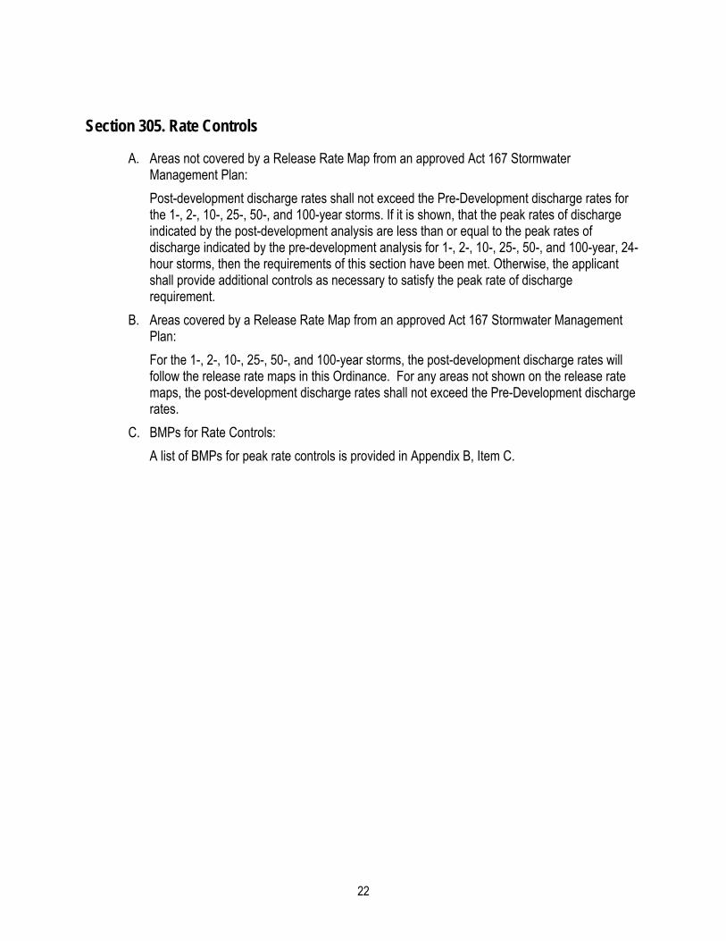
Section 305. Rate Controls
A. Areas not covered by a Release Rate Map from an approved Act 167 Stormwater Management Plan:
Post-development discharge rates shall not exceed the Pre-Development discharge rates for the 1-, 2-, 10-, 25-, 50-, and 100-year storms. If it is shown, that the peak rates of discharge indicated by the post-development analysis are less than or equal to the peak rates of discharge indicated by the pre-development analysis for 1-, 2-, 10-, 25-, 50-, and 100-year, 24-hour storms, then the requirements of this section have been met. Otherwise, the applicant shall provide additional controls as necessary to satisfy the peak rate of discharge requirement.
B. Areas covered by a Release Rate Map from an approved Act 167 Stormwater Management Plan:
For the 1-, 2-, 10-, 25-, 50-, and 100-year storms, the post-development discharge rates will follow the release rate maps in this Ordinance. For any areas not shown on the release rate maps, the post-development discharge rates shall not exceed the Pre-Development discharge rates.
C. BMPs for Rate Controls:
A list of BMPs for peak rate controls is provided in Appendix B, Item C.

23
Section 306. Calculation Methods
A. Stormwater runoff from all project sites shall be calculated using a generally accepted calculation technique that is based on the NRCS soil cover complex method. Table 306-1 summarizes acceptable computation methods and the method selected by the Qualified Professional shall be based on the individual limitations and suitability of each method for a particular site.
TABLE 306-1
ACCEPTABLE COMPUTATION METHODOLOGIES FOR STORMWATER MANAGEMENT PLANS
Method Method Developed By Applicability
TR-20/WINTR20
(or commercial computer package based on TR-20)
USDA NRCS
Applicable where use of full hydrology computer model is desirable or necessary.
TR-55/WINTR55
(or commercial computer package based on TR-55)
USDA NRCS Applicable for land development plans within limitations described in TR-55.
HEC-HMS US Army Corps of Engineers
Applicable where use of full hydrologic computer model is desirable or necessary.
Rational Formula
(or commercial computer package based on Rational Formula)
Emil Kuichling (1889) For sites less than fifty acres and with time of concentration less than 60 minutes (Tc< 60 min), or as approved by the Municipality
Other Methods such as SWMM, WMS, etc.
Varies Other computation methodologies approved by the Municipality
Note: Successors to the above methods are also acceptable.
B. All calculations consistent with this Ordinance using the soil cover complex method shall use the appropriate design rainfall depths and intensities for the various return period storms according to the approximate center of the proposed development site, in accordance with the values obtained from the National Oceanic and Atmospheric Administration’s (NOAA) Hydrometeorological Design Studies Center Precipitation Frequency Data Server (PFDS) at the following location for the Commonwealth of Pennsylvania:
http://hdsc.nws.noaa.gov/hdsc/pfds/index.html Applicant shall provide documentation of PFDS data location (latitude and longitude in degrees/minutes/seconds).

24
C. All calculations using the Rational Formula shall use rainfall intensities consistent with appropriate times-of-concentration for overland flow and return periods from the NOAA, PFDS website, the Design Storm Curves from PennDOT Publication 13M, Design Manual Part 2, Chapter 10, and NOAA Atlas 14.
D. Times-of-concentration for overland flow shall be calculated using the methodology presented in Chapter 3 of Urban Hydrology for Small Watersheds, NRCS, TR-55 (as amended or replaced from time to time by NRCS). Times-of-concentration for channel and pipe flow shall be computed using Manning's equation. NRCS lag equation divided by 0.6 as acceptable method for Tc in undeveloped areas.
E. In order to reduce stormwater runoff volumes from developed areas and encourage groundwater recharge, underground basin drains, infiltration trenches, dry wells, and cisterns are permitted to which roof leaders may be connected. These drains consist of stone-filled basins that temporarily store and release water below ground surface. Plans for such facilities shall be submitted to the Municipality for approval, and the basins shall be used only in those areas where soils, geologic, and water table conditions permit.
F. Runoff Curve Numbers (CN) for both existing and proposed conditions to be used in the soil cover complex method shall be obtained from Table 2-2 of the TR-55 manual.
G. Runoff coefficients (C) for both existing and proposed conditions for use in the Rational Formula are provided in Appendix D.
H. All flow assumptions and source of supporting data shall be provided as part of the overall plan. The Municipality reserves the right to reject any submitted values, despite the source, and to provide a substitute source for use by the applicant.
I. Where uniform flow is anticipated, the Manning equation shall be used for hydraulic computations, and to determine the capacity of open channels, pipes, and storm sewers. Values for Manning's roughness coefficient (n) shall be consistent with generally accepted values from a legitimate and verifiable source. All flow assumptions and source of supporting data shall be provided as part of the overall plan. The Municipality reserves the right to reject any submitted values, despite the source, and to provide a substitute source for use by the applicant. Full flow capacity shall be assumed for closed conduits. Storm sewer systems consisting of more than three pipe junctions shall be designed using hydraulic grade line computations.
J. Outlet structures for Stormwater management facilities shall be designed to meet the performance standards of this Ordinance using any generally accepted hydraulic analysis technique or method. The design of any Stormwater detention facilities intended to meet the performance standards of this Ordinance shall be verified by routing the design storm hydrograph through these facilities using the Storage-Indication Method. For drainage areas greater than 200 acres in size, the design storm hydrograph shall be computed using a calculation method that produces a full hydrograph (i.e. TR-20, TR-55, and HEC-HMS).
K. Stormwater management and related facilities shall be provided: 1. To permit unimpeded flow of natural watercourses. Such flow may be redirected as
required, subject to the approval of the Pennsylvania Department of Environmental Protection and the Municipality.
2. To ensure adequate drainage of all street low points. L. Storm sewers and related installations:
1. When located in undedicated land, they shall be placed within a drainage easement not less than twenty (20) feet wide as approved by the Municipality.

25
2. The use of properly designed, graded, and vegetated drainage channels is encouraged in lieu of storm sewers in commercial and industrial areas and, where approved by the Municipality, in residential areas. Such swales shall be designed to not only carry the required discharge without excessive erosion, but also to increase the time of concentration, reduce the peak discharge and velocity, and permit the water to percolate into the soil, where appropriate. Criteria related to· the use and design of drainage swales are as follows:
a. The maximum encroachment of water on the roadway pavement along roadside swales in cut areas shall not exceed half of a through traffic lane during a 10-year frequency storm of five (5) minute duration. Frequent and/or sustained flooding of the sub-base shall be avoided.
b. The design of all vegetated channels shall, as a minimum, conform to the design procedures outlined in the Erosion and Sediment Pollution Control Program Manual (PA DEP). Inlets shall be provided to limit road shoulder encroachment and water velocity.
c. The side slope for any vegetated drainage channel requiring mowing of the vegetation shall have a maximum grade of three (3) horizontal to one (1) vertical on those areas to be mowed. Maximum side slopes for any vegetated drainage channel shall be two (2) horizontal to one (1) vertical.
d. Erosion Prevention: All drainage swales shall be designed to prevent the erosion of the bed and bank areas. Suitable temporary and/or permanent stabilization during vegetative cover establishment shall be provided to prevent erosion.
e. Storm sewers or drainage swales shall discharge to a detention or retention basin to attenuate the peak rate and volume, respectively of stormwater runoff, except as provided in the plan.
3. Storm inlet types and inlet assemblies shall conform to the Pennsylvania Department of Transportation Standards for Roadway Construction as approved by the Municipality.
4. When evidence available to the Municipality indicates that existing storm sewers have sufficient capacity as determined by hydrograph summation and are accessible, proposed stormwater facilities may connect to the existing storm sewers so long as the peak rate of discharge does not exceed the amount permitted by this Article.
M. Downstream Analysis 1. Where deemed necessary by the Municipal Engineer, the applicant shall submit an
analysis of the impacts of detained stormwater flows on downstream areas within the watershed, established with the concurrence of the Municipal Engineer. The analysis shall include hydrologic and hydraulic calculations necessary to determine the impact of peak discharge modifications of the proposed development on critical locations such as dams, tributaries, existing developments, undersized culverts, and flood prone areas. Review and comment of the analysis by the Engineer of a downstream Municipality shall be obtained as deemed necessary.
N. Multiple Use Basins: The design and construction of multiple use stormwater detention facilities are strongly encouraged. In addition to stormwater management; where appropriate, facilities allow for recreational uses including: ball fields, play areas, picnic grounds, etc. Provision for parking facilities within basins and permanent wet ponds with stormwater management capabilities may also be appropriate. Prior approval and consultation with the

26
Municipality are required before design. Multiple use basins shall be constructed so that potentially dangerous conditions are not created.
O. Alternative Detention Facilities: Alternative stormwater detention facilities including roof top, subsurface basins or tanks and in-pipe detention storage, or other approved alternative designs are permitted as determined by the Municipality.
P. Landscaping of Stormwater management facilities: Facilities constructed with berms or earthen embankments shall not be landscaped along the top of the impoundment berm, embankment, nor shall other facility areas constructed from compacted fill materials be landscaped. Heavy vegetative cover root penetration can cause soil weakening and damage to facility piping.
Section 307. Other Requirements
A. All wet basins shall be designed in a manner that seeks to mitigate the proliferation of mosquito breeding habitats and the potential spread of the West Nile Virus. This can be accomplished through the following means:
1. The design of a Stormwater wetland/wet basin must include the selection of hydrophytic plant species for their pollutant uptake capabilities and for not contributing to the potential for vector mosquito breeding. The establishment of hydrophytic vegetation will promote the population of the wetland/ wet basin by amphibians and other mosquito predators. In natural wetlands, predatory insects and amphibians are effective at keeping mosquito populations in check during the larval stage of development while birds and bats prey on adult mosquitoes. Refer to Appendix B of the PA SWM BMP Manual (current version) for hydrophytic native plant species lists.
2. Aeration fountains and stocked fish can be added to keep larval mosquito populations in check.
B. The Municipality reserves the right to disapprove any design that would result in the construction or continuation of a Stormwater problem area.
C. When the elevation of any existing or proposed entrance to a structure, including windows, is lower than the elevation of the public cartway serving that site, a grading plan shall be submitted, reviewed and approved as part of the SWM approval process for the proposed structure.
D. No Stormwater detention facility shall be placed within fifty (50) feet of a special geologic feature. No subsurface Stormwater conveyance facility shall be constructed within fifty (50) feet of a special geologic feature, without written permission of the Municipality.
E. Stormwater management facilities located outside of existing or proposed public rights-of-way shall be located within and accessible by easements granted to the Municipality as follows:
1. Access Easements: Where proposed stormwater management facilities are not adjacent to proposed or existing public right-of-ways or are not accessible due to physical constraints, as determined by the Municipality, a twenty (20) feet wide access easement specifying rights of entry shall be provided commensurate to need. Access easements shall provide for vehicle ingress and egress on grades of less than ten (10) percent for carrying out inspection or maintenance activities. A permanent fifteen-foot wide vehicular access road within the easement(s) shall be provided around all SWM BMPs, such as ponds and infiltration structures. The access roads shall connect to a public thoroughfare. The access road (when applicable) will also provide access at a
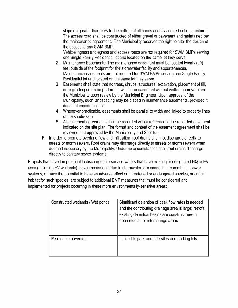
27
slope no greater than 20% to the bottom of all ponds and associated outlet structures. The access road shall be constructed of either gravel or pavement and maintained per the maintenance agreement. The Municipality reserves the right to alter the design of the access to any SWM BMP. Vehicle ingress and egress and access roads are not required for SWM BMPs serving one Single Family Residential lot and located on the same lot they serve.
2. Maintenance Easements: The maintenance easement must be located twenty (20) feet outside of the footprint for the stormwater facility and appurtenances. Maintenance easements are not required for SWM BMPs serving one Single Family Residential lot and located on the same lot they serve.
3. Easements shall state that no trees, shrubs, structures, excavation, placement of fill, or re-grading are to be performed within the easement without written approval from the Municipality upon review by the Municipal Engineer. Upon approval of the Municipality, such landscaping may be placed in maintenance easements, provided it does not impede access.
4. Whenever practicable, easements shall be parallel to width and linked to property lines of the subdivision.
5. All easement agreements shall be recorded with a reference to the recorded easement indicated on the site plan. The format and content of the easement agreement shall be reviewed and approved by the Municipality and Solicitor.
F. In order to promote overland flow and infiltration, roof drains shall not discharge directly to streets or storm sewers. Roof drains may discharge directly to streets or storm sewers when deemed necessary by the Municipality. Under no circumstances shall roof drains discharge directly to sanitary sewer systems.
Projects that have the potential to discharge into surface waters that have existing or designated HQ or EV uses (including EV wetlands), have impairments due to stormwater, are connected to combined sewer systems, or have the potential to have an adverse effect on threatened or endangered species, or critical habitat for such species, are subject to additional BMP measures that must be considered and implemented for projects occurring in these more environmentally-sensitive areas:
Constructed wetlands / Wet ponds
Significant detention of peak flow rates is needed and the contributing drainage area is large; retrofit existing detention basins are construct new in open median or interchange areas
Permeable pavement
Limited to park-and-ride sites and parking lots
28
Manufactured products: Subsurface storage, water quality inlets, etc.
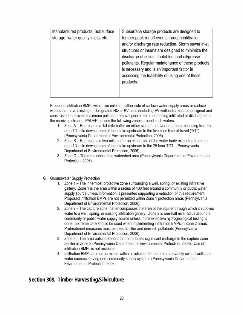
Subsurface storage products are designed to temper peak runoff events through infiltration and/or discharge rate reduction. Storm sewer inlet structures or inserts are designed to minimize the discharge of solids, floatables, and oil/grease pollutants. Regular maintenance of these products is necessary and is an important factor in assessing the feasibility of using one of these products.
Proposed infiltration BMPs within two miles on either side of surface water supply areas or surface waters that have existing or designated HQ or EV uses (including EV wetlands) must be designed and constructed to provide maximum pollutant removal prior to the runoff being infiltrated or discharged to the receiving stream. PADEP defines the following zones around such waters:
1. Zone A – Represents a 1/4 mile buffer on either side of the river or stream extending from the area 1/4 mile downstream of the intake upstream to the five hour time-of-travel (TOT) (Pennsylvania Department of Environmental Protection, 2006).
2. Zone B – Represents a two-mile buffer on either side of the water body extending from the area 1/4 mile downstream of the intake upstream to the 25 hour TOT. (Pennsylvania Department of Environmental Protection, 2006).
3. Zone C – The remainder of the watershed area (Pennsylvania Department of Environmental Protection, 2006).
G. Groundwater Supply Protection 1. Zone 1 – The innermost protective zone surrounding a well, spring, or existing infiltrative
gallery. Zone 1 is the area within a radius of 400 feet around a community or public water supply source unless information is presented supporting a reduction of this requirement. Proposed infiltration BMPs are not permitted within Zone 1 protection areas (Pennsylvania Department of Environmental Protection, 2006).
2. Zone 2 – The capture zone that encompasses the area of the aquifer through which it supplies water to a well, spring, or existing infiltration gallery. Zone 2 is one-half mile radius around a community or public water supply source unless more extensive hydrogeological testing is done. Extreme care should be used when implementing infiltration BMPs in Zone 2 areas. Pretreatment measures must be used to filter and diminish pollutants (Pennsylvania Department of Environmental Protection, 2006).
3. Zone 3 – The area outside Zone 2 that contributes significant recharge to the capture zone aquifer in Zone 2 (Pennsylvania Department of Environmental Protection, 2006). Use of infiltration BMPs is not restricted.
4. Infiltration BMPs are not permitted within a radius of 50 feet from a privately owned wells and water sources serving non-community supply systems (Pennsylvania Department of Environmental Protection, 2006)
Section 308. Timber Harvesting/Silviculture
29
It is not the intention for this section to serve as an ordinance or regulatory document governing the practice of timber harvesting/silviculture activities. However, the intent of this section and the included guidelines is to address specific stormwater management issues related to or caused by such timber harvesting activities. These regulations shall not be considered a timber-harvesting ordinance, nor do they relieve the applicant from meeting any additional timber harvesting regulations already in place. The municipality, at its own discretion, may choose to enact any new or enforce any existing ordinance directly related to timber harvesting.
A. Logging operators shall address and comply with all applicable standards for erosion and sedimentation control and stream crossing regulations under 25 Pennsylvania Code, Chapter 102, Erosion Control Rules and Regulations, issued pursuant to the Clean Stream Law, and 25 Pennsylvania Code, Chapter 105, Dam and Waterway Management Rules and Regulations, issued pursuant to the Dam Safety and Encroachments Act. Any additional governing or amended regulations shall hereby govern all logging plans, including those mentioned by the regulatory authorities listed or by any other entity garnishing such authoritative and administrative powers.
B. Logging operators shall address and comply with all applicable standards for stormwater management as set forth in the Stormwater Management Plan of Lawrence County, and any regulations, stormwater management plans and ordinances issued or enacted pursuant thereto.
C. All logging operations shall be conducted in strict adherence with PA DEP Document 3930-BK-DEP4016 (Revised 06/2007) or the most recent, amended version.
D. At a minimum, logging operators shall address each of the following: 1. Design of the logging road system, taking into account its influence on surface runoff,
this includes haul roads, skid roads, and skid trails 2. Water control structures 3. Stream crossings and potential wetland impacts 4. Log landings 5. Maintenance 6. Public road use 7. Retirement of logging roads, log landings, stream crossings, structures, etc. and
restoration of the same E. Controlling erosion on logging road systems is required.
1. A functional drainage system of culverts, dips, bridges, turnouts, and out-sloping or in-sloping roads to handle stormwater runoff.
2. Keep road reasonably free of ruts, curbs and logging debris that may prevent water from moving freely into drainage structures.
3. Reduce or eliminate traffic on haul roads, skid trails and landings during wet weather and during periods when frozen roads are thawing.
4. The erosion and sediment pollution control plan must show how haul roads, skid roads, and landings are proposed to be retired.
30
ARTICLE IV - SWM SITE PLAN AND REPORT REQUIREMENTS
Section 401. Plan and Report Contents
A. All regulated activities that do not fall under the exemption criteria referenced herein shall submit a SWM Site Plan and Report to the municipality for review. These criteria shall apply to the total proposed development even if development is to take place in stages.
B. The following items shall be included in the SWM Site Plan: 1. Appropriate sections from the Municipal SALDO and other applicable ordinances shall
be followed in preparing the SWM Site Plans. In instances where the Municipality lacks Subdivision and Land Development regulations, the County SALDO shall be followed.
2. The SWM Site Plan shall provide the following information: a. Unless specifically given written permission by the Municipality, the following
must be shown on the SWM Site Plan, prepared in a form which meets the requirements for recording in the County Office of the Recorder of Deeds:
i. Annotated maps, drawings, engineering plans, and construction details. Said plan shall be prepared by a Qualified Professional, with said preparer's seal and registration number affixed to the plan. Plans for tracts of less than twenty (20) acres shall be drawn at a scale of one inch equals no more than fifty (50) feet; for tracts of twenty (20) acres or more, plans shall be drawn at a scale of one inch equals no more than one hundred (100) feet. Plans shall be submitted on the following sheet sizes: 18" x 24", 24" x 36", or 36" x 42". All lettering shall be drawn to a size to be legible if the plans are reduced to half size. All sheets comprising a submission shall be on one size.
ii. The name of the proposed development and the name and address of the owner of the property and the individual or firm preparing the plan.
iii. Date of submission and revision, graphic scale, and North arrow. iv. Total tract boundary with distances marked to the nearest foot and
bearings to the nearest degree and the total acreage of the tract. v. Key map (drawn to scale) showing all existing natural and man-made
features beyond the property boundary affected by the project and the extent of the watershed or sub-basin which drains through the project site.
vi. Existing and proposed topographic contours shall be provided at intervals not greater than five (5) feet for existing and proposed conditions.
vii. Topographic contours at intervals less than five (5) feet may be required for flat sites, and to depict certain existing and future stormwater management features. The reference datum used to develop topographic contours shall be stated on the plans.

31
viii. Existing and proposed use, including the total area of impervious surfaces after construction.
ix. Location and selected plant material used for vegetative filter paths to sinkholes, stream buffers, buffer yards, wetlands, streams, and other waters of the Commonwealth, and the location of all notices to be posted, as specified in this Ordinance. If stormwater management facilities are off-site, a note on the plan referring to location and agreements indicating responsibility for conveyance to and maintenance of the facilities; all such off-site facilities shall meet the design standards and criteria specified in this Ordinance, and details of the facilities shall be included with the plan.
b. An erosion and sediment pollution control plan, as prepared for and submitted to the County Conservation District.
c. Plan and profile, and construction detail drawings of all SWM BMPs including open channels and swales.
d. Locations of existing watercourses (including stream name per PA DEP Chapter 93 designation, or otherwise noted as “unnamed tributary” with Chapter 93 numeric designation) and existing and proposed on-lot wastewater facilities, water supply wells, and infiltration areas.
e. Locations of all access and maintenance easements, suitable for Recording. f. Signature blocks:
The following signature block for the Municipality: “_____________________________, on this date (date of signature), has reviewed this SWM Site Plan in accordance with the design standards and criteria of the applicable Municipal Ordinances."
The following signature block for the Qualified Professional: “____________________________, on this date (date of signature), hereby certify that this SWM Site Plan was prepared in strict accordance with all of the design standards and criteria of all applicable Municipal Ordinances.”
The following signature block for the Applicant/Owner: “_____________________________, on this date (date of signature), has acknowledged that I/we and/or my/our assignees/grantees shall be responsible for maintenance of the stormwater management system shown hereon, in accordance with approved stormwater management ownership and maintenance plan for this project, and that such stormwater system shall remain as a permanent fixture that cannot be altered, replaced, or removed without prior written approval from the Municipality."
g. A note indicating that a copy of the Recorded Record drawings will be
submitted to the Municipality by the Applicant's Registered Engineer or Surveyor for all stormwater facilities prior to occupancy, or the release of the surety bond. The Municipality reserves the right to authorize the Municipal Engineer to review said Record Drawings.

32
C. The following items shall be included in the SWM Report 1. The overall Stormwater management concept for the project. 2. A determination of Site Conditions in accordance with Appendix B. A detailed site
evaluation shall be completed for projects proposed in areas of carbonate geology or karst topography, and other environmentally sensitive areas such as brownfields.
3. Stormwater runoff design computations and documentation as specified in this Ordinance, or otherwise necessary to demonstrate that the maximum practicable measures have been taken to meet the requirements of this Ordinance, including the recommendations and general requirements in Section 301. All calculations shall be submitted to the Municipality on computation sheets for approval. If the Municipality determines through review and independent computation that the size(s) of stormwater management facilities is insufficient, the Municipality may require the applicant to increase the size(s) of said stormwater management facilities. If the storm drainage system design is completed on a computer installation, sufficient supporting data shall be provided to allow comprehensive review by Municipal officials.
4. Expected project construction schedule. 5. The effect of the project (in terms of runoff volumes and peak flows) on adjacent properties
and on any existing Municipal Stormwater collection system that may receive runoff from the project site.
6. Copies of all permits and applications (where required) by the Pennsylvania Department of Environmental Protection, Pennsylvania Department of Transportation (PA DOT), and U.S. Army Corps of Engineers (USACOE) and other regulatory agencies.
7. The SWM Site Plan shall include an operation and maintenance (O&M) plan for all existing and proposed physical stormwater management facilities. This plan shall address long-term ownership and responsibilities for operation and maintenance as well as schedules and costs for O&M activities.
8. Hydrologic and hydraulic computations for all existing and proposed stormwater management facilities and measures.
9. Construction specifications for SWM BMPs and storm drainage systems. 10. Each stormwater management report shall contain provisions that clearly set forth the
ownership and maintenance responsibility of all permanent stormwater management, and erosion and sediment control facilities. Including:
a. Description of Maintenance Requirements. b. Establishment of suitable easements for access to all facilities by Public
Officials, in accordance with this Article. c. Identification of the responsible party or entity for ownership and maintenance
of both temporary and permanent stormwater management facilities. In meeting this requirement, the following options are hereby provided for upon approval by the Municipality. Facilities may be incorporated within individual lots so that the respective lot owners will own and be responsible for maintenance in accordance with recorded deed restriction. A description of the facility or system and the terms of the required maintenance shall be incorporated as part of the deed to the property. Ownership and maintenance may be the responsibility of a Property Owners Association. The stated responsibilities of the Property Owners Association in terms of owning and maintaining the stormwater management facilities shall

33
be submitted with final plans for determination of their adequacy, and upon their approval shall be recorded with the approved subdivision plan among the County deed records. In addition, the approved subdivision plan and any deed written from said plan for a lot or lots shown herein shall contain a condition that it shall be mandatory for the owner or owners of said lot to be members of said Property Owners Association.
d. For stormwater management facilities that are proposed as part of the site development plan, the applicant will be required to execute a developer agreement and a maintenance agreement with the Municipality for the construction and continued maintenance of the facilities prior to the signature approval on the final plan. Access for inspection by the municipality of all such facilities deemed critical to the public welfare at any reasonable time shall be provided.
e. In the event the above priorities cannot be achieved, or where it is required, the facilities may be dedicated to the Municipality in accordance with this Ordinance. As a condition of Municipality acceptance of said facilities, the applicant shall provide thirty (30) percent of the cost of improvements, in the form of a maintenance bond, as estimated by the applicant's Qualified Professional, and approved by the Municipality, to cover contingency maintenance costs for eighteen (18) months from the date of stormwater management facilities acceptance of dedication. The thirty (30) percent bond shall be based on the construction costs of the detention basin and outlet structure within the area dedicated to the municipality.
11. Example Report Sections:
Introduction Existing Site Conditions Models Existing Soils Information Volume Mitigation
Description And Background Information Peak Rate Mitigation
Description And Background Information Pre-Development Conditions Post-Development ConditionsStormwater/Detention Basin Hydraulics Storm Drain Design Peak-Rate Mitigation Results
Effect of Project on Adjacent Properties Expected Project Construction Schedule Ownership and Maintenance Appendices
Volume Mitigation Calculations, Worksheets And Information Peak Rate Mitigation Calculations And Information Water Quality Worksheets And Information Precipitation Source Data SCS Runoff Curve Numbers, Rational Runoff Coefficients, Manning’s coefficients Miscellaneous Computations Infiltration Rate Test Data

34
General References Construction Specifications for SWM BMPs
D. Small Project SWM Application
1. Refer to Appendix F.
Section 402. Plan Submission
A. Five (5) copies of the SWM Site Plan shall be submitted as follows: 1. Two (2) copies to the Municipality. 2. One copy to the Municipal Engineer (when applicable) 3. One (1) copy to the County Planning Commission/Office
B. Additional copies shall be submitted as requested by the Municipality.
Section 403. Plan Review
A. The SWM Site Plan shall be reviewed by a Qualified Professional for the Municipality for consistency with the provisions of this ordinance. After review, the Qualified Professional shall provide a written recommendation for the Municipality to approve or disapprove the SWM Site Plan. If it is recommended to disapprove the SWM Site Plan, the Qualified Professional shall state the reasons for the disapproval in writing. The Qualified Professional also may recommend approval of the SWM Site Plan with conditions and, if so, shall provide the acceptable conditions for approval in writing. The SWM Site Plan review and recommendations shall be completed within the time allowed by the Municipalities Planning Code for reviewing subdivision and land development plans.
B. The Municipality shall notify the applicant in writing within 45 calendar days whether the SWM Site Plan is approved or disapproved. If the SWM Plan involves a Subdivision or Land Development Plan, the notification period is 90 days. If a longer notification period is provided by other statute, regulation, or ordinance, the applicant will be so notified by the Municipality. If the Municipality disapproves the SWM Plan, the Municipality shall cite the reasons for disapproval in writing.
C. The Municipality's approval of a SWM Site Plan shall be valid for a period not to exceed five (5) years. This five-year period shall commence on the date that the Municipality signs the approved SWM Site Plan. If Stormwater management facilities included in the approved SWM Site Plan have not been constructed, or if a Record Drawing of these facilities has not been approved within this five-year time period, then the Municipality may consider the SWM Site Plan disapproved and may revoke any and all permits. SWM Site Plans that are considered disapproved by the Municipality shall be resubmitted in accordance with this Ordinance.
Section 404. Modification of Plans
A modification to a submitted SWM Site Plan that involves a change in SWM BMPs or techniques, or that involves the relocation or re-design of SWM BMPs, or that is necessary because soil or other conditions are not as stated on the SWM Site Plan as determined by the Municipality, shall require a resubmission of

35
the modified SWM Site Plan in accordance with this Article. The SWM Plan review process shall start over as stated under Section 403. Section 405. Resubmission of Disapproved SWM Site Plans
A disapproved SWM Site Plan may be resubmitted, with the revisions addressing the Municipality's concerns, to the Municipality in accordance with this Article. The applicable Review Fee must accompany a resubmission of a disapproved SWM Site Plan. Section 406. Record Drawings and Final Inspection
A. The Applicant/Developer shall be responsible for completing Record Drawings of all SWM BMPs included in the approved SWM Site Plan. The Record Drawings and an explanation of any discrepancies with the design plans shall be submitted to the Municipality.
B. The submission shall include a signed statement from a Qualified Professional verifying that all permanent SWM BMPs have been constructed according to the plans and specifications and approved revisions thereto.
C. After receipt of the signed statement and the Record Drawings by the Municipality, the Municipality may conduct a final inspection.

36
ARTICLE V - OPERATION AND MAINTENANCE
Section 501. Responsibilities
A. The Municipality shall make the final determination on the continuing maintenance responsibilities prior to final approval of the SWM Site Plan. The Municipality may require a dedication of such facilities as part of the requirements for approval of the SWM Site Plan. Such a requirement is not an indication that the Municipality will accept the facilities. The Municipality reserves the right to accept the ownership and operating responsibility for any or the entire Stormwater management controls.
B. All SWM BMPs shall be enumerated as permanent real estate appurtenances and recorded as deed restrictions.
C. The Operation and Maintenance Plan shall be recorded as a restrictive deed covenant that runs with the land.
D. The Municipality shall take enforcement actions against an owner for any failure to satisfy the provisions of this Article.
Section 502. Operation and Maintenance Agreements
The owner is responsible for Operation and Maintenance of the SWM BMP’s, and for preparing an Operation and Maintenance Agreement in accordance with Appendix C. If the owner fails to adhere to the Operation and Maintenance Agreement, the Municipality may perform the services required and charge the owner appropriate fees. Non-payment of fees may result in a lien against the property.

37
ARTICLE VI - FEES AND EXPENSES
Section 601. General
The Municipality may include all costs incurred in the Review Fee charged to an Applicant. The Review Fee may include but not be limited to costs for the following:
A. Administrative/clerical processing. B. Review of the SWM Site Plan. C. Attendance at Meetings. D. Inspections. E. Qualified Professional Review and Meeting Costs. F. Recording Fees and Costs for Plan Reduction to Meet County Recording Requirements (if
required). As part of the permit application packet, and prior to Perry Township submitting the SWM Site Plan to Perry Township's engineering company for review, the Applicant must enter into a Review Fee Reimbursement Agreement with Perry Township, and pay the specified amount in the Agreement to Perry Township. The application will not be considered complete, and the Review will not start, until the Fee Agreement has been signed and the deposit/specified amount has been paid. It is also acknowledged that if additional fee expense results from further review by the Perry Township engineering company, such fees will be reimbursed to Perry Township before the permit application packet can be submitted to the Perry Township Building Code Enforcement Inspection Company.
38
ARTICLE VII - PROHIBITIONS
Section 701. Prohibited Discharges and Connections
A. Any drain or conveyance, whether on the surface or subsurface, which allows any non-Stormwater discharge including sewage, process wastewater, and wash water to enter the Waters of this Commonwealth is prohibited.
B. No person shall allow, or cause to allow, discharges into surface waters of this Commonwealth that are not composed entirely of stormwater, except (1) as provided in Subsection C below and (2) discharges allowed under a state or federal permit.
C. The following discharges are authorized unless they are determined to be significant contributors to pollution of the Waters of this Commonwealth:
Discharges from fire fighting activities Flows from riparian habitats and wetlands
Potable water sources including water line and fire hydrant flushing
Uncontaminated water from foundations or from footing drains
Irrigation drainage Lawn watering
Air conditioning condensate De-chlorinated swimming pool discharges
Springs Uncontaminated groundwater
Water from crawl space pumps Water from individual residential car washing
Pavement wash waters where spills or leaks of toxic or hazardous materials have not occurred (unless all spill material has been removed) and where detergents are not used
Routine external building wash down (which does not use detergents or other compounds)
D. In the event that the Municipality or PA DEP determines that any of the discharges identified in
Section 701.C, significantly contribute to pollution of the Waters of this Commonwealth, the Municipality or PA DEP will notify the responsible person(s) to cease the discharge.
Section 702. Roof Drains
Roof drains and sump pumps shall discharge to infiltration or vegetative BMP’s and to the maximum extent practicable to satisfy the criteria for Disconnected Impervious Areas (Appendix G). Section 703. Alteration of BMPs
No person shall modify, remove, fill, landscape, or alter any SWM BMPs without the prior written approval of the Municipality.

39
ARTICLE VIII - ENFORCEMENT AND PENALTIES
Section 801. Right-of-Entry
As a condition of approval of an Applicant’s Stormwater management site plan, and upon presentation of proper credentials, the Applicant agrees that the Municipality, and/or their agents, may enter at reasonable times upon any property within the Municipality to inspect the condition of the Stormwater structures and facilities concerning any aspect regulated by this Ordinance. Section 802. Inspection
SWM BMPs shall be inspected by the land owner/developer (including Municipality for dedicated facilities) according to the following list of frequencies:
A. Annually for the first 5 years. B. Once every 3 years thereafter, C. During or immediately after the cessation of a 10-year or greater storm.
Section 803. Enforcement
A. It shall be unlawful for a person to undertake any Regulated Activity except as provided in an approved SWM Site Plan unless specifically exempted in Section 302.
B. It shall be unlawful to alter, remove, or fail to implement any control structure required by the SWM Site Plan.
C. Compliance Inspections regarding implementation of the SWM Site Plan are a responsibility of the Municipality.
804. Suspension and Revocation
A. Any approval for a Regulated Activity may be suspended or revoked by the Municipality for: 1. Non-compliance with, or failure to implement any provision of the approval, including
Record Drawings and Operations and Maintenance Agreements. 2. A violation of any provision of this Ordinance or any other applicable law, Ordinance, rule or
regulation relating to the Regulated Activity. 3. The creation of any condition or the commission of any act during the Regulated Activity which
constitutes or creates a hazard or nuisance, pollution, or which endangers the life or property of others.
B. A suspended approval may be reinstated by the Municipality when: 1. The Municipality has inspected and approved the corrections to the violations that
caused the suspension. 2. The Municipality is satisfied that the violation has been corrected.
C. An approval that has been revoked by the Municipality cannot be reinstated. The Applicant may apply for a new approval under the provisions of this Ordinance.

40
D. If a violation causes no immediate danger to life, public health, or property, at its sole discretion, the Municipality may provide a limited time for the owner to correct the violation. In these cases, the Municipality will provide the owner, or the owner's designee, with a written notice of the violation and the time allowed the owner to correct the violation. If the owner does not correct the violation within the allowed time, the Municipality may revoke or suspend any, or all, applicable approvals and permits pertaining to any provision of this Ordinance.
Section 805. Penalties
A. Any person violating the provisions of this Ordinance may be assessed a civil penalty of not more than $ 1000.00 for each violation, recoverable with costs. Each day that the violation continues constitutes a separate violation, and penalties shall be cumulative.
B. In addition, the Municipality, may institute injunctive, mandamus or any other appropriate action or proceeding at law or in equity for the enforcement of this Ordinance. Any court of competent jurisdiction shall have the right to issue restraining orders, temporary or permanent injunctions, mandamus or other appropriate forms of remedy or relief.
C. The cost of removal, fine, and penalties hereinabove mentioned may be entered by the Municipality as a lien against such property, or properties of individual members of a Property Owners Association, in accordance with existing provisions of law.
D. If the Municipality determines at any time that any permanent stormwater management facility has been eliminated, altered, or improperly maintained, the Municipality shall advise the responsible party of required corrective measures, and shall provide said responsible party with a specific period to implement the required corrective measures. If such action is not taken by the property owner, the Municipality may cause the work to be done and back-charge all costs to the property owners in accordance with this Ordinance.
Section 806. Appeals
A. Any person aggrieved by any action of the Municipality or its designee, relevant to the provisions of this Ordinance, may appeal to the Municipality within thirty (30) days of that action.
B. Any person aggrieved by any decision of the Municipality, relevant to the provisions of this Ordinance, may appeal to the County Court Of Common Pleas in the county where the activity has taken place within thirty (30) days of the Municipality’s decision.

41
ARTICLE IX – REFERENCES
A. Pennsylvania Department of Environmental Protection. (DEP Doc. #363-0300-002 or current version). Pennsylvania Stormwater Best Management Practices Manual. Harrisburg, PA.
B. Pennsylvania Department of Environmental Protection. 363-2134-008 (2000), as amended and updated. Erosion and Sediment Pollution Control Program Manual. Harrisburg, PA.
C. United States Department of Agriculture (USDA), National Resources Conservation Service (NRCS). National Engineering Handbook. Part 630: Hydrology, 1969-2001. Originally published as the National Engineering Handbook, Section 4: Hydrology. Available online at: http://www.wcc.nrcs.usda.gov/hydro/hydro-techref-neh-630.html
D. United States Department of Agriculture (USDA), Natural Resources Conservation Service (NRCS). 1986. Technical Release 55: Urban Hydrology for Small Watersheds, 2nd Edition. Washington, D.C.
E. US Department of Commerce (USDC), National Oceanic and Atmospheric Administration (NOAA), National Weather Service (NWS), Hydrometeorological Design Studies Center. 2004-2006. Precipitation-Frequency Atlas of the United States. Atlas 14, Volume 2, Silver Spring, Maryland, 20910. Internet address: http://hdsc.nws.noaa.gov/hdsc/pfds/
F. United States Department of Department of Transportation (US DOT), Federal Highway Administration (FHA). 2001. Hydraulic Engineering Circular Number 22 (HEC-22), Urban Drainage Design Manual.
G. PennDOT Drainage Manual, Publication Number 584, as amended H. Philadelphia Water Department. 2006. Stormwater Management Guidance Manual. Section
4.2.2: Integrated Site Design. Philadelphia, PA.

42
ENACTED and ORDAINED at the regular meeting of the
PERRY TOWNSHIP BOARD OF SUPERVISORS
On this 10TH day of March, 2011.
This Ordinance shall take effect March 13, 2011. John Zias, Supervisor Timothy Boots, Supervisor Dori McElwain, Supervisor
SEAL Attest: Janice Marshall, Secretary

A - 1
APPENDIX A
LOW IMPACT DEVELOPMENT PRACTICES ALTERNATIVE APPROACHES FOR MANAGING STORMWATER RUNOFF
Natural hydrologic conditions may be altered by development practices, which may create impervious surfaces, destroy drainage swales, construct storm sewers, and change local topography. A traditional approach to drainage has been to remove runoff from sites as quickly as possible and capture it in downstream detention basins. This approach leads to the degradation of water quality as well as additional expenditures for detaining and managing concentrated runoff. The recommended approach is to promote practices that will minimize post-development runoff rates and volumes and minimize needs for artificial conveyance and storage facilities. To simulate pre-development hydrologic conditions, increased infiltration often is helpful to offset the effects of increasing the area of impervious surfaces. The ability to increase infiltration depends upon the soil types and land use. Preserving natural hydrologic conditions requires careful site design that includes preservation of natural drainage features, minimization of impervious surfaces, reduction of hydraulic connectivity of impervious surfaces, and protection of natural depression storage areas. A well-designed site will contain a mix of all these features. The following describes various techniques to achieve this:
A. Preserve Drainage Features. Protect natural drainage features, particularly vegetated drainage swales and channels. Locate streets and adjacent storm sewers away from valleys and swales.
B. Protect Natural Depression Storage Areas. Depression storage areas have no surface outlet, or they drain very slowly. Depressions shall be protected and the storage capacity shall be incorporated into required detention facilities.
C. Avoid Creating Impervious Surfaces. Reduce impervious surfaces to the maximum extent possible. Building footprints, sidewalks, driveways and other features shall be minimized.
D. Avoid Connecting Impervious Surfaces. Route roof runoff over lawns and avoid using storm sewers. Grade sites to increase the travel time of Stormwater runoff. Avoid concentrating runoff.
E. Use Pervious-Paving Materials. Use pervious materials for driveways, parking lots, access roads, sidewalks, bike trails and hiking trails. Provide pervious strips between streets and sidewalks.
F. Reduce Setbacks. Reduce setbacks for buildings to shorten the driveways and entry walks. G. Construct Cluster Developments. Construct Cluster Developments to reduce street length per
lot.
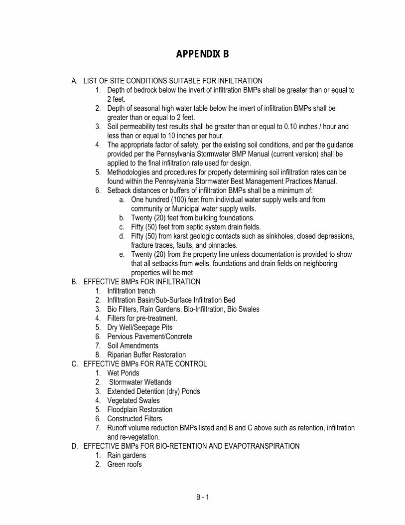
B - 1
APPENDIX B
A. LIST OF SITE CONDITIONS SUITABLE FOR INFILTRATION 1. Depth of bedrock below the invert of infiltration BMPs shall be greater than or equal to
2 feet. 2. Depth of seasonal high water table below the invert of infiltration BMPs shall be
greater than or equal to 2 feet. 3. Soil permeability test results shall be greater than or equal to 0.10 inches / hour and
less than or equal to 10 inches per hour. 4. The appropriate factor of safety, per the existing soil conditions, and per the guidance
provided per the Pennsylvania Stormwater BMP Manual (current version) shall be applied to the final infiltration rate used for design.
5. Methodologies and procedures for properly determining soil infiltration rates can be found within the Pennsylvania Stormwater Best Management Practices Manual.
6. Setback distances or buffers of infiltration BMPs shall be a minimum of: a. One hundred (100) feet from individual water supply wells and from
community or Municipal water supply wells. b. Twenty (20) feet from building foundations. c. Fifty (50) feet from septic system drain fields. d. Fifty (50) from karst geologic contacts such as sinkholes, closed depressions,
fracture traces, faults, and pinnacles. e. Twenty (20) from the property line unless documentation is provided to show
that all setbacks from wells, foundations and drain fields on neighboring properties will be met
B. EFFECTIVE BMPs FOR INFILTRATION 1. Infiltration trench 2. Infiltration Basin/Sub-Surface Infiltration Bed 3. Bio Filters, Rain Gardens, Bio-Infiltration, Bio Swales 4. Filters for pre-treatment. 5. Dry Well/Seepage Pits 6. Pervious Pavement/Concrete 7. Soil Amendments 8. Riparian Buffer Restoration
C. EFFECTIVE BMPs FOR RATE CONTROL 1. Wet Ponds 2. Stormwater Wetlands 3. Extended Detention (dry) Ponds 4. Vegetated Swales 5. Floodplain Restoration 6. Constructed Filters 7. Runoff volume reduction BMPs listed and B and C above such as retention, infiltration
and re-vegetation. D. EFFECTIVE BMPs FOR BIO-RETENTION AND EVAPOTRANSPIRATION
1. Rain gardens 2. Green roofs

B - 2
3. Constructed Wetlands 4. Select, commercially available products (as approved by the Municipality)
Consult the Pennsylvania Stormwater Best Management Practices Manual for all available BMPs and stormwater technologies that can effectively mitigate stormwater runoff, volume, and quality issues.

C - 1
APPENDIX C
OPERATION AND MAINTENANCE AGREEMENT
STORMWATER BEST MANAGEMENT PRACTICES
THIS AGREEMENT, made and entered into this ____________ day of ____________, 20__, by and between ____________________________________, (hereinafter the “Landowner”), and ________________________________, ___________________________ County, Pennsylvania, (hereinafter “Municipality”);
WITNESSETH
WHEREAS, the Landowner is the owner of certain real property as recorded by deed in the land records of ________________ County, Pennsylvania, Deed Book ___________ at Page ______, (hereinafter “Property”).
WHEREAS, the Landowner is proceeding to build and develop the Property; and WHEREAS, the Stormwater management BMP Operation and Maintenance Plan approved by the
Municipality (hereinafter referred to as the “Plan”) for the property identified herein, which is attached hereto as Appendix A and made part hereof, as approved by the Municipality, provides for management of Stormwater within the confines of the Property through the use of Best Management Practices (BMPs); and
WHEREAS, the Municipality, and the Landowner, his successors and assigns, agree that the
health, safety, and welfare of the residents of the Municipality and the protection and maintenance of water quality require that on-site Stormwater Best Management Practices be constructed and maintained on the Property; and
WHEREAS, the Municipality requires, through the implementation of the SWM Site Plan, that
Stormwater management BMP’s as required by said Plan and the Municipal Stormwater Management Ordinance be constructed and adequately operated and maintained by the Landowner, his successors and assigns.
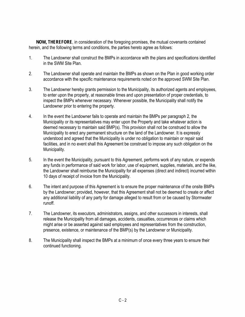
C - 2
NOW, THEREFORE, in consideration of the foregoing promises, the mutual covenants contained herein, and the following terms and conditions, the parties hereto agree as follows:
1. The Landowner shall construct the BMPs in accordance with the plans and specifications identified in the SWM Site Plan.
2. The Landowner shall operate and maintain the BMPs as shown on the Plan in good working order accordance with the specific maintenance requirements noted on the approved SWM Site Plan.
3. The Landowner hereby grants permission to the Municipality, its authorized agents and employees, to enter upon the property, at reasonable times and upon presentation of proper credentials, to inspect the BMPs whenever necessary. Whenever possible, the Municipality shall notify the Landowner prior to entering the property.
4. In the event the Landowner fails to operate and maintain the BMPs per paragraph 2, the Municipality or its representatives may enter upon the Property and take whatever action is deemed necessary to maintain said BMP(s). This provision shall not be construed to allow the Municipality to erect any permanent structure on the land of the Landowner. It is expressly understood and agreed that the Municipality is under no obligation to maintain or repair said facilities, and in no event shall this Agreement be construed to impose any such obligation on the Municipality.
5. In the event the Municipality, pursuant to this Agreement, performs work of any nature, or expends any funds in performance of said work for labor, use of equipment, supplies, materials, and the like, the Landowner shall reimburse the Municipality for all expenses (direct and indirect) incurred within 10 days of receipt of invoice from the Municipality.
6. The intent and purpose of this Agreement is to ensure the proper maintenance of the onsite BMPs by the Landowner; provided, however, that this Agreement shall not be deemed to create or affect any additional liability of any party for damage alleged to result from or be caused by Stormwater runoff.
7. The Landowner, its executors, administrators, assigns, and other successors in interests, shall release the Municipality from all damages, accidents, casualties, occurrences or claims which might arise or be asserted against said employees and representatives from the construction, presence, existence, or maintenance of the BMP(s) by the Landowner or Municipality.
8. The Municipality shall inspect the BMPs at a minimum of once every three years to ensure their continued functioning.

C - 3
This Agreement shall be recorded at the Office of the Recorder of Deeds of ______________ County, Pennsylvania, and shall constitute a covenant running with the Property and/or equitable servitude, and shall be binding on the Landowner, his administrators, executors, assigns, heirs and any other successors in interests, in perpetuity.
ATTEST:
WITNESS the following signatures and seals:
(SEAL) For the Municipality:
_______________________________
(SEAL) For the Landowner:
_______________________________
ATTEST:
_____________________________ (City, Borough, Township)
County of ___________________________, Pennsylvania
I, _______________________________________, a Notary Public in and for the County and State aforesaid, whose commission expires on the __________ day of __________________, 20____, do hereby certify that ________________________________________ whose name(s) is/are signed to the foregoing Agreement bearing date of the ___________ day of ___________________, 20____, has acknowledged the same before me in my said County and State.
GIVEN UNDER MY HAND THIS ___________________ day of ___________, 200___.
________________________________ _______________________________
NOTARY PUBLIC (SEAL)

D - 1
APPENDIX D

E - 1
APPENDIX E
SMALL PROJECT SWM APPLICATION AND WORKSHEET

E - 2
Lawrence County Small Project Stormwater Management Application
As required by the Municipality’s Act 167 Stormwater Management Ordinance2, a Small Project Stormwater Management Plan is required whenever more than 2,500 square feet of impervious surface is proposed3. Impervious surfaces are areas that prevent the infiltration of water into the ground and shall include, but not be limited to, roofs, patios, garages, storage sheds and similar structures, and any new streets or sidewalks.
Table
-1 To Calculate Impervious Surfaces Please Complete This Table
Surface Type Length X Width = Proposed Impervious Area
Building (area per downspout)
x = x = x = x =
Driveway x = x = x =
Parking Areas x = x = x =
Patios/Walks x = x = x = x =
Other x = x = x =
Total Impervious Surface Area to be Managed (Sum of All Areas)
If the Total Impervious Surface Area is LESS THAN 2,500 Square Feet, read, acknowledge, and sign below.
If the Total Impervious Surface Area is GREATER THAN OR EQUAL TO 2,500 Square Feet, complete the remainder of the Application.
Property Owner Acknowledges that submission of inaccurate information may result in a stop work order or permit revocation. Acknowledgement of such is by signature below. I declare that I am the owner or owner's legal representative. I further acknowledge that the information provided is accurate and Municipal employees are granted access to the above-described property for review and inspection as may be required.
:Owner Date: (Signature) (Print Name) 2 The municipality can require the applicant to provide supplemental and additional information beyond the Small Project SWM Application if there is a threat to property, health or safety. 3 Refer to Ordinance Section 501, Responsibilities for justification of this application

E - 3
CREDITS Credit 1: DISCONNECTION OF IMPERVIOUS AREA
When runoff from impervious areas is directed to a pervious area that allows for infiltration, filtration, and increased time of concentration, all or parts of the impervious areas may qualify as Disconnected Impervious Area (DIA). Using the criteria below, determine the portion of the impervious area that can be excluded from the calculation of total impervious areas. Criteria: An impervious area is considered to be completely or partially disconnected if it meets the requirements below:
Rooftop area draining to a downspout is ≤500 sf
Paved area draining to a discharge is ≤1,000 sf
Flow path of paved impervious area is not more than 75’
Soil at discharge is not designated as hydrologic soil group “D”
Flow path at discharge area has a positive slope ≤5%
Gravel strip or other spreading device is required at paved discharges
Length of Flow Path from
Discharge Point* (ft)
DIA Credit Factor
0-14 1.0 15-29 0.8 30-44 0.6 45-59 0.4 60-74 0.2
75 or More 0
* Flow path cannot include impervious surfaces and must be at least 15’ from any impervious surfaces
Table E-2 Calculate DIA Credit and Required Capture Volume
Surface Type Proposed Impervious
Area (from previous sheet)
X DIA
Credit Factor
= Impervious Area to be Managed
÷ = Required Capture
Volume (ft3)
Building (area per downspout)
x = ÷ 6 =
x = ÷ 6 =
x = ÷ 6 =
x = ÷ 6 =
Driveway x = ÷ 6 =
x = ÷ 6 =
x = ÷ 6 =

E - 4
Parking Areas x = ÷ 6 =
x = ÷ 6 =
x = ÷ 6 =
Patios/Walks x = ÷ 6 =
x = ÷ 6 =
x = ÷ 6 =
x = ÷ 6 =
Other x = ÷ 6 =
x = ÷ 6 =
x = ÷ 6 =
Small Project SWM Plan Worksheet - Instructions
The Stormwater Management Ordinance developed through the Lawrence County Act 167 Stormwater Management Plan regulates compliance requirements for Stormwater Management in this jurisdiction. A complete copy of the ordinance can be obtained by contacting the Lawrence County Planning Department. Regulated activities shall be conducted only after the Municipality approves a stormwater management plan. The Lawrence County Act 167 Stormwater Management Plan will assist you in preparing the necessary information and plans for the Municipality to review and approve. This document will constitute an approved plan if all of the relevant components are installed in their entirety AND no part of the stormwater system adversely affects any other property, nor adversely affect any septic systems or drinking water wells on this, or any other, parcel. If an alternative system is to be used a plan will need to be submitted to the Municipality for approval. A design by a Qualified Professional may be required for sites that are more complex.
Construction details and materials for Stormwater BMPs can be found in the PADEP Stormwater Management BMP Manual (current version) at:
(http://www.depweb.state.pa.us/portal/server.pt/community/best_management_practices_manual/10631 ). All BMPs must be installed in their entirety AND the BMPs will be located as not to adversely affect other property, nor any septic systems or drinking water wells on this, or any other, parcel.

E - 5
Small Project SWM Plan Worksheet Based upon the information you have provided, a Stormwater Plan IS Required for this development activity. The Stormwater Management Ordinance developed through the Lawrence County Act 167 Stormwater Management Plan regulates compliance requirements for Stormwater Management in this jurisdiction. A complete copy of the Plan can be obtained from the Lawrence County Department of Planning.
Regulated activities shall be conducted only after the Municipality approves a stormwater management plan. The Lawrence County Act 167 Stormwater Management Plan will assist you in preparing the necessary information and plans for the Municipality to approve. This document will constitute an approved plan if all of the relevant details are to be installed in the entirety AND no part of the stormwater system adversely affects any other property, nor adversely affects any septic systems or drinking water wells on this, or any other parcel. If an alternative system is to be used, a plan will need to be submitted to the Municipality for approval. A design by a qualified professional may be required for more complex sites.
PLEASE INITIAL BELOW TO INDICATE THE STORMWATER MANAGEMENT PLAN COMPONENTS FOR THIS SITE
Minimum Control #1 Erosion and Sediment Pollution Control Minimum Control #2 Preservation of Natural Drainage Systems and Outfalls
The relevant details from the Lawrence County Act 167 Stormwater Management Plan will be installed in their entirety AND the systems will be located as not to adversely affect other property, nor any septic systems or drinking water wells on this, or any other parcel.
To meet this requirement as well as State Water Quality requirements, the following must be installed and maintained:
Capture Volume to be Managed (ft3) Conversion Surface Area of BMP (ft2)
By Rain Garden 6” Ponding; 2’ Soil Depth X 1.20
Dry Well or Infiltration Trench 2’-6” Aggregate Depth
X 1.25
:Total Total:
In lieu of meeting the above, an alternative and/or professional design is attached for approval AND the system will be located as not to adversely affect other property, any septic systems or drinking water wells on this, or any other, parcel.

E - 6
Site Sketch Plan showing:
Property lines with dimensions Proposed septic system, if applicable
Proposed buildings with dimensions Proposed well site, if applicable
Proposed impervious surfaces with dimensions Proposed stormwater managements system(s)
Operation and Maintenance Agreement
Condition on approval - The stormwater management plan must be fully implemented prior to a request for final inspection of the building or zoning permit.
Acknowledgement - By executing below, the Owner acknowledges the following:
I declare that I am the owner of the property.
The information provided is accurate.
I further acknowledge that municipal representatives are granted access to the above-described property for review and inspection as may be required.
(Owner Signature) (Date)
(Print Name)

E - 7

Attachment A - 1
ATTACHMENT A
ADDITIONAL ORDINANCE AND TECHNICAL GUIDELINES
TOOLBOX

Attachment A - 2
ADDITIONAL ORDINANCE AND TECHNICAL GUIDELINES
Municipalities may wish to use the following standards or requirements. Some of these are a replacement for standards and requirements in the Model Ordinance, and some are in addition to those listed in the Model Ordinance.
Article III • Municipal ordinances may contain more specific design references than included in this model ordinance, or alternatively, reference the Pennsylvania Handbook of Best Management Practices for Developing Areas (1998) or the 2000 Maryland Stormwater Design Manual, among others, for more guidance.
• Please note that additional design references may require additional standards for
maintenance, applicability, and enforcement, to name a few. Those responsible for the enforcement and interpretation of the local ordinances should become familiar with any references cited in any adopted ordinance.
• For municipalities with existing stormwater ordinances, this model ordinance could be
used as the framework for rewriting the existing ordinance with each locality adding complimentary and/or additional language to completely describe the design standards for stormwater management. These may include standards already adopted and in practice. This model ordinance could also be adopted as a separate component of a municipal code (with appropriate cross-referencing to zoning and subdivision ordinances). A complete review and comment by the municipality’s solicitor and engineer is part of establishing or modifying local regulations and design standards.
• The Municipality may (at its own discretion) wish to require a pre-design conference.
• The Municipality may (at its own discretion) allow the use of the Rational Formula to
estimate peak discharges only from drainage areas that are less than fifty acres and for storm sewer sizing calculations, which are typically small in size. For drainage areas fifty acres or greater in size discharging to a storm drainage collection system, a more accurate methodology should be considered.
• In lieu of using the data obtained from the NOAA, PFDS website, the Municipality may
approve the use of alternate sources of rainfall data, including the PA DOT Design Storm Curve values for Region 1, per the most current version of the PA DOT Drainage Manual. A rainfall duration of 24-hours shall be used for calculations and the distribution type shall be Type-II, per TR-55.
• The Municipality may approve the use of any generally accepted full hydrograph
approximation technique that shall use a total runoff volume that is consistent with the volume from a method that produces a full hydrograph.
• To intercept stormwater runoff along streets at intervals reasonable related to the
extent and grade of the area drained, and to prevent substantial flow of water across intersections or flooded intersections during storms, in accordance with the procedures in the Pennsylvania Department of Transportation Design Manual Part 2. DM-2, Chapter 10 (PA DOT).

Attachment A - 3
To ensure adequate and unimpeded flow of stormwater under driveways in, near, or across natural watercourses or drainage swales. Suitable pipes or other waterways shall be provided as necessary. To properly drain stormwater runoff from all land development projects. All lot and open areas shall be designed to drain to the nearest practical street or drainage system, existing or proposed, as defined by the Municipal Engineer, with no impact on adjoining properties, unless an area specifically designed for stormwater detention is provided.
Storm sewers, where required by zoning and land use densities, shall be placed under or immediately adjacent to the roadway side of the curb, or as directed by the Municipality, when parallel to the street within the right-of-way.
The design capacity of storm sewers shall be in accordance with PennDOT Drainage Manual, Publication Number 584, as amended. Storm drainage systems shall be designed without surcharging inlets to provide conveyance of stormwater runoff into a detention basin or similar facility utilized to manage the rate of stormwater runoff. To avoid surcharging inlets, and to ensure that inlets will receive stormwater runoff, the hydraulic grade line at the inlet shall be at least six (6) inches below the elevation of the inlet grate. Where site grading will direct stormwater runoff from the 100-year design storm to a detention basin or similar facility utilized to manage the rate of stormwater runoff, then the storm sewer may be designed for the 10-year design storm. Where site grading will not direct stormwater runoff from the 100-year design storm to a detention basin or similar facility utilized to manage the rate of stormwater runoff, then the storm sewer shall be designed for the 100-year design storm. The location of the hydraulic grade line for the 100-year design storm shall be graphically shown on the required storm sewer profile drawings. Conveyance of storms to the detention basin, up to and including the 100-year frequency, shall be provided so as not to endanger life or seriously damage property.
Accessible drainage structures shall be located on a continuous storm sewer system at all vertical dislocations, at all locations where a transition in storm sewer pipe sizing is required, at all vertical and horizontal angle points exceeding five (5) degrees, and at all points of convergence of two or more influent storm sewer mains. The construction locations of accessible drainage structures shall be as indicated on the subdivision drainage plan or area drainage plan approved by the Municipality.
• Swales shall be designed in accordance with Design of Roadside Channels with
Flexible Linings, Hydraulic Engineering Circular No. 15 (US DOT, FHA).
Where vegetated drainage swales are used in lieu of or in addition to storm sewers, they shall be designed to carry the 10-year discharge without erosion, and also to increase the time of concentration, reduce the peak discharge and velocity, and permit the water to percolate into the soil.
• Deed restrictions may be required on property (ies) containing drainage swales and/or
perennial streams. When required, these deed restrictions shall specify that no property owner obstruct or alter any drainage swale or perennial stream identified in the stormwater management plan.
• Minimum storm sewer diameter or equivalent diameter shall be 15 inches.
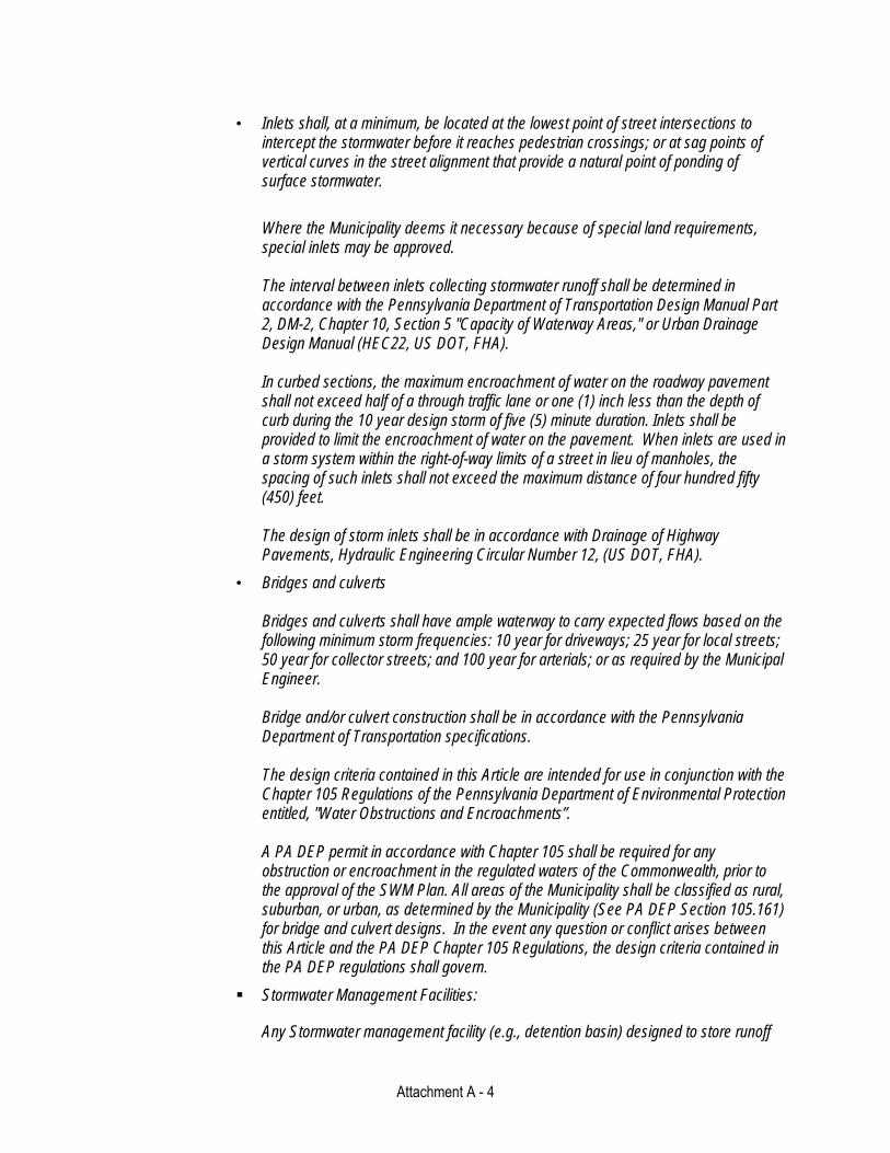
Attachment A - 4
• Inlets shall, at a minimum, be located at the lowest point of street intersections to intercept the stormwater before it reaches pedestrian crossings; or at sag points of vertical curves in the street alignment that provide a natural point of ponding of surface stormwater.
Where the Municipality deems it necessary because of special land requirements, special inlets may be approved. The interval between inlets collecting stormwater runoff shall be determined in accordance with the Pennsylvania Department of Transportation Design Manual Part 2, DM-2, Chapter 10, Section 5 "Capacity of Waterway Areas," or Urban Drainage Design Manual (HEC22, US DOT, FHA). In curbed sections, the maximum encroachment of water on the roadway pavement shall not exceed half of a through traffic lane or one (1) inch less than the depth of curb during the 10 year design storm of five (5) minute duration. Inlets shall be provided to limit the encroachment of water on the pavement. When inlets are used in a storm system within the right-of-way limits of a street in lieu of manholes, the spacing of such inlets shall not exceed the maximum distance of four hundred fifty (450) feet. The design of storm inlets shall be in accordance with Drainage of Highway Pavements, Hydraulic Engineering Circular Number 12, (US DOT, FHA).
• Bridges and culverts Bridges and culverts shall have ample waterway to carry expected flows based on the following minimum storm frequencies: 10 year for driveways; 25 year for local streets; 50 year for collector streets; and 100 year for arterials; or as required by the Municipal Engineer. Bridge and/or culvert construction shall be in accordance with the Pennsylvania Department of Transportation specifications. The design criteria contained in this Article are intended for use in conjunction with the Chapter 105 Regulations of the Pennsylvania Department of Environmental Protection entitled, "Water Obstructions and Encroachments”. A PA DEP permit in accordance with Chapter 105 shall be required for any obstruction or encroachment in the regulated waters of the Commonwealth, prior to the approval of the SWM Plan. All areas of the Municipality shall be classified as rural, suburban, or urban, as determined by the Municipality (See PA DEP Section 105.161) for bridge and culvert designs. In the event any question or conflict arises between this Article and the PA DEP Chapter 105 Regulations, the design criteria contained in the PA DEP regulations shall govern.
Stormwater Management Facilities:
Any Stormwater management facility (e.g., detention basin) designed to store runoff

Attachment A - 5
and requiring a berm or earthen embankment required or regulated by this Ordinance shall be designed to provide an emergency spillway to handle flow up to and including the 100-year proposed conditions and may be subject to PA DEP Chapter 105 regulations. Facilities requiring berms or earthen embankments shall include the construction of anti-seep collars along the length of the outlet barrel and containing the proposed phreatic line. Anti-seep collars should be designed in accordance with the PA DEP Erosion Control Manual.
Stormwater management facilities shall be installed prior to or concurrent with any earthmoving or land disturbances which they will serve. Earthen embankments and berms shall be constructed using 6” soil lifts and compacted with the use of sheepsfoot roller equipment.
The design of all Stormwater management facilities over limestone formations shall include measures to prevent groundwater contamination and, where required, sinkhole formation. Soils used for the construction of Stormwater management facilities shall have moderate to low erodibility factors (i.e. "K" factors of 0.32 or less).
Outlet structures within detention/retention/wet basins shall incorporate childproof, non-clogging trash racks or grates over all horizontally oriented openings. All vertically oriented openings over twelve (12) inches or larger in any dimension where entry by a child could cause injury or death shall be covered with childproof, non-clogging trash racks, except where such openings carry perennial stream flows. Design openings less than six (6) inches in any dimension shall be covered with a pipe screen. Measures to completely drain detention/retention basins in the event of clogging of the primary design opening(s) shall be incorporated into the design of basin outlet structures. Basin outlet pipes shall have a minimum inside diameter of fifteen (15) inches or a cross-sectional area of one hundred seventy-six (176) square inches, except that pipes under a twenty-five foot or greater fill shall not be less than twenty-four (24) inches or a cross-sectional area of four hundred fifty-three (453) square inches, and shall consist of reinforced concrete.
Outlet aprons shall be designed and shall extend at a minimum to the toe of the basin slope. Where spillways will be used to manage peak discharges in excess of the 10-year storm, such spillways shall be constructed to withstand the pressures of impounded waters and convey flows at computed outlet velocities without erosion.
Energy dissipaters and/or level spreaders shall be installed at points where pipes or drainageways discharge to or from Stormwater management facilities. Stormwater management facilities shall be constructed with an appropriate sedimentation forebay and a low-flow channel at a minimum slope of 1%
Stormwater management facilities shall be designed to release their total volumes detained within the following maximum time periods:
Roofs and Parking Lots - 24 hours.

Attachment A - 6
Detention Basin - 48 hours.
Infiltration Facilities - 72 hours. The intermittent treatment of wetlands/wet basins with commercially available
products designed to curtail the breeding habitats of mosquitoes and other invasive insects may be permitted at the discretion of the Municipality.
Publications from the PA Department of Health and the Penn State Cooperative Extension concerning West Nile Virus identify aggressive public education about the risks posed by standing water in artificial containers (tires, trash cans, rain gutters, bird baths) as the most effective method to control vector mosquitoes.
Stream Buffers
Stream Buffers shall be provided for new development sites using the following requirements:
A minimum stream buffer width of 50 feet landward in each direction from the top of stream banks is required for all waterways having both a defined bank and a contributing watershed area of greater than 100 acres.
A minimum stream buffer width of 35 feet landward in each direction from the centerline of the waterway is required for smaller waterways having a contributing watershed area of less than 100 acres and greater than 10 acres.
The stream buffer area shall be maintained in a natural state.
When wetland(s) extend beyond the edge of the required buffer width, the buffer shall be adjusted so that the buffer consists of the extent of the wetland plus a 25-foot zone extending beyond the wetland edge.
Stream buffer averaging may be applied to account for encroachments such as road crossings. The following criteria must be met in order to use buffer averaging on a development site:
Buffer averaging is required for water quality buffers that have stream crossings.
An overall average buffer width of at least 50 feet must be achieved within the boundaries of the property to be developed. Stream buffer corridors on adjoining properties cannot be included with buffer averaging on a separate property, even if owned by the same property owner.
The average width must be calculated based upon the entire length of stream bank that is located within the boundaries of the property to be developed. When calculating the buffer length, the natural stream channel shall be followed.
Stream buffer averaging shall be applied to each side of a stream independently. If the property being developed encompasses both sides of a stream, buffer averaging can be applied to both sides of the stream, but must be applied to both sides of the stream independently.
The total width of the buffer shall not be less than 25 feet at any location, except at approved stream crossings. Those areas of the buffer having a minimum width of 25 feet (or less at approved stream crossings) can comprise no more than 50 percent of the buffer length.

Attachment A - 7
Stream buffer locations and widths shall be shown on all subdivision plans with notations requiring that they be maintained in a natural state.
Stream buffers shall be shown on all grading and erosion and sedimentation control plans. The defined stream buffer location shall be properly recorded. The recording shall provide a plan illustrating the stream buffer location, width and the requirement that it be maintained in a natural state.
When there is a conflict between the buffer requirements in this ordinance and any other municipal ordinance, the more restrictive standard shall apply.
In order to promote overland flow and infiltration, roof drains shall not discharge directly to streets or storm sewers. Roof drains may discharge directly to streets or storm sewers when deemed necessary by the Municipality. Under no circumstances shall roof drains discharge directly to sanitary sewer systems.
Stormwater drainage systems shall be provided to permit unimpeded flow along natural watercourses, except as modified by stormwater management facilities or open channels consistent with this Ordinance.
Areas of existing diffused drainage discharge shall be subject to any applicable discharge criteria in the general direction of existing discharge, whether proposed to be concentrated or maintained as diffused drainage areas, except as otherwise provided by this ordinance. If diffused flow is proposed to be concentrated and discharged onto adjacent property, the Applicant must document that adequate downstream conveyance facilities exist to safely transport the concentrated discharge, or otherwise prove that no erosion, sedimentation, flooding or other harm will result from the concentrated discharge.
Where a development site is traversed by watercourses, drainage easements shall be provided conforming to the line of such watercourses. The terms of the easement shall prohibit excavation, the placing of fill or structures, and any alterations that may adversely affect the flow of stormwater within any portion of the easement. In addition, maintenance, including mowing of vegetation within the easement shall be required, except as approved by the appropriate governing authority.
When it can be shown that, due to topographic conditions, natural drainageways on the site cannot adequately provide for drainage, open channels may be constructed conforming substantially to the line and grade of such natural drainageways. Work within natural drainageways shall be subject to approval by PA DEP through the Joint Permit Application process, or, where deemed appropriate by PA DEP, through the General Permit process.
• Sinkhole Protection:
Stormwater from roadways, parking lots, storm sewers, roof drains, or other concentrated stormwater runoff paths shall not be discharged directly into sinkholes. To protect sensitive Karst areas, the Municipal Engineer may require basins to contain an impervious liner. The liner may be of the impervious membrane type, placed in accordance with the manufacturer's recommendations, or an approved alternative as approved by the Municipal Engineer.

Attachment A - 8
Article IV Municipalities or the County may wish to include a requirement for SWM Permit application and issuance that is integrated with their Building Permit process.
Article VI It is recommended that the Municipalities and/or the County institute the use of a Developers Agreement or similar mechanism that incorporates an obligation for the Applicant/Developer to reimburse Municipal/County Qualified Professional Review costs.


![TRUSTEE ACT - Kenya Law Reports · Trustee CAP. 167 LAWS OF KENYA TRUSTEE ACT CHAPTER 167 Revised Edition 2012 [1982] Published by the National Council for Law Reporting with …](https://img.pdfslide.net/doc/110x75/5b875d6e7f8b9a46538b48e3/trustee-act-kenya-law-trustee-cap-167-laws-of-kenya-trustee-act-chapter-167.jpg)