Embed Size (px)
Citation preview
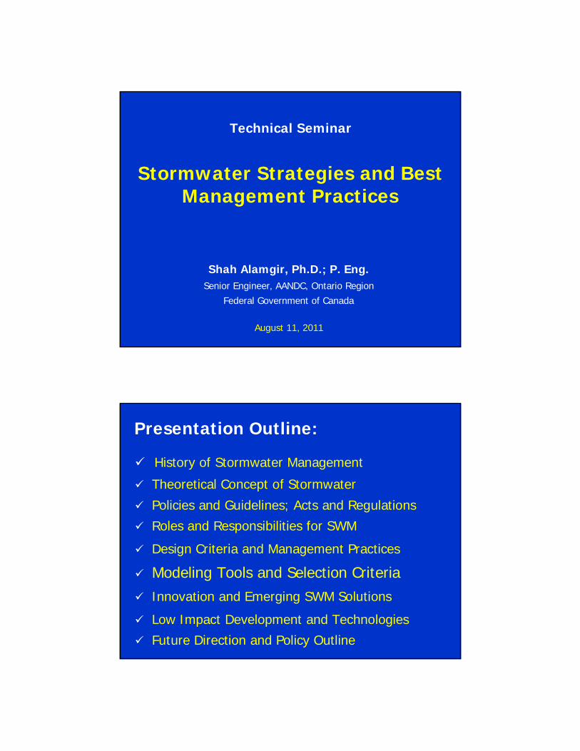
Stormwater Strategies and Best Management Practices
Shah Alamgir, Ph.D.; P. Eng.Senior Engineer, AANDC, Ontario Region
Federal Government of Canada
Technical Seminar
August 11, 2011
Presentation Outline:
History of Stormwater Management
Theoretical Concept of Stormwater
Policies and Guidelines; Acts and Regulations
Roles and Responsibilities for SWM
Design Criteria and Management Practices
Modeling Tools and Selection Criteria Innovation and Emerging SWM Solutions
Low Impact Development and Technologies
Future Direction and Policy Outline
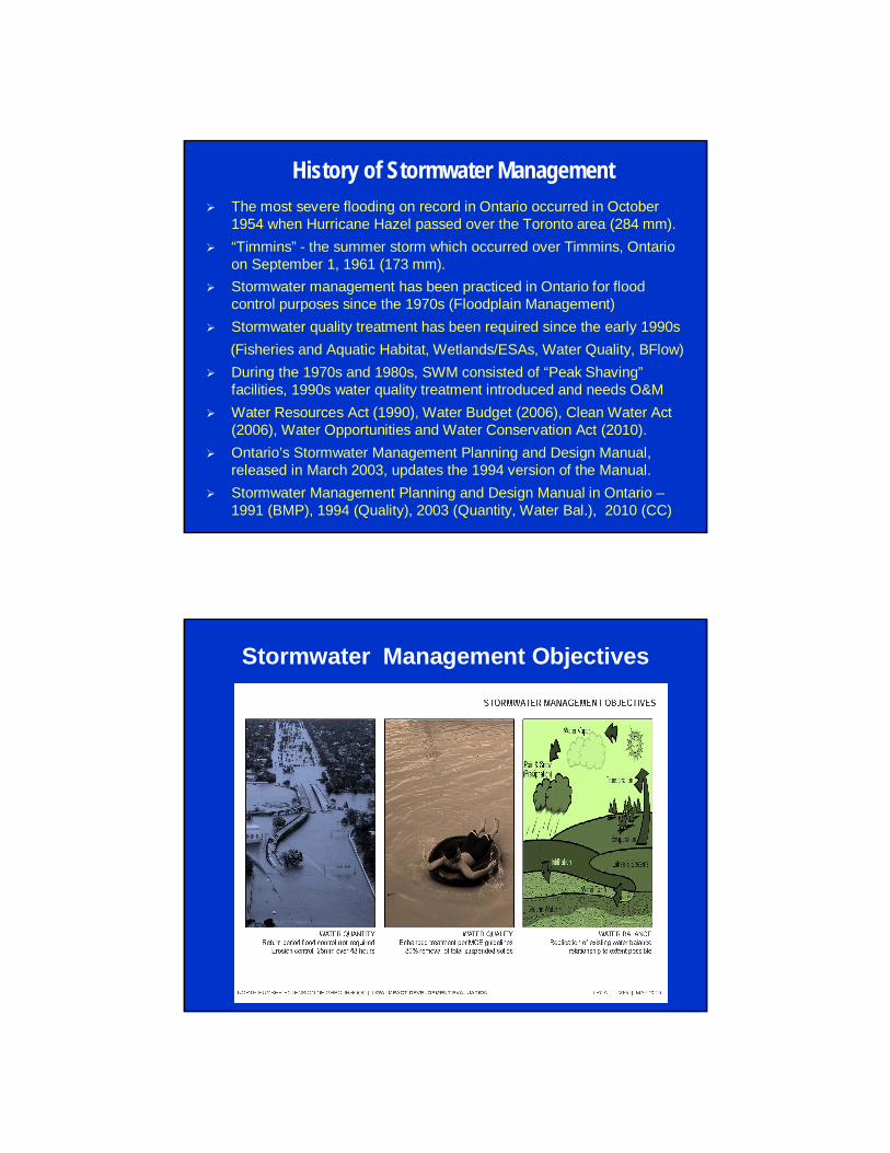
History of Stormwater Management The most severe flooding on record in Ontario occurred in October
1954 when Hurricane Hazel passed over the Toronto area (284 mm). “Timmins” - the summer storm which occurred over Timmins, Ontario
on September 1, 1961 (173 mm). Stormwater management has been practiced in Ontario for flood
control purposes since the 1970s (Floodplain Management) Stormwater quality treatment has been required since the early 1990s
(Fisheries and Aquatic Habitat, Wetlands/ESAs, Water Quality, BFlow) During the 1970s and 1980s, SWM consisted of “Peak Shaving”
facilities, 1990s water quality treatment introduced and needs O&M Water Resources Act (1990), Water Budget (2006), Clean Water Act
(2006), Water Opportunities and Water Conservation Act (2010). Ontario’s Stormwater Management Planning and Design Manual,
released in March 2003, updates the 1994 version of the Manual. Stormwater Management Planning and Design Manual in Ontario –
1991 (BMP), 1994 (Quality), 2003 (Quantity, Water Bal.), 2010 (CC)
Stormwater Management Objectives

Theoretical Concept of Stormwatero Stormwater is water that flows across the land and is routed into
drainage systems and ultimately into our natural areas such as creeks, lakes and wetlands. Stormwater is not limited to precipitation but may also come from many other sources.
o Stormwater management is the planning for and controlling of stormwater runoff from rain and melted snow for the purposes of reducing downstream erosion, water quality degradation, flooding, reduce the impact of changes in landuse on aquatic environment.
Theoretical Concept of StormwaterUrbanization and Increasing Impervious Surface (source USDA)
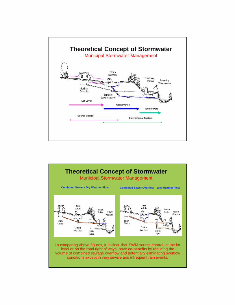
Theoretical Concept of StormwaterMunicipal Stormwater Management
End of Pipe
Lot LevelConveyance
Source ControlConventional System
Theoretical Concept of StormwaterMunicipal Stormwater Management
Combined Sewer – Dry Weather Flow Combined Sewer Overflow – Wet Weather Flow
In comparing above figures, it is clear that SWM source control, at the lot level or on the road right of ways, have co-benefits by reducing the
volume of combined sewage overflow and potentially eliminating overflow conditions except in very severe and infrequent rain events.
Acts and Regulations
Ontario Water Resources Act, 1990, MOE (Section 53 –Sewage Works Approval and Section 34 & 90 - PTTW)
Planning Act, 1983, MMAH; (Section 51.1 – SD Plan) Provincial Policy Statement, 2005, MMAH, Ontario Conservation Authorities Act, 1946, Ontario Regulation of Development, Interface with Wetlands
and Alterations to Shorelines and Watercourse, Ont. Reg. 97/04; CA Act, Section 28(1) – FFW and WM
Lakes and Rivers Improvement Act, 1990, MNR Canada-Ontario Agreement Respecting the Great
Lakes Basin Ecosystem, 2002 (Canada–Ontario Agreement, 1971)
Acts and Regulations Nutrient Management Act, 2002, MAFRA, Ontario Oak Ridges Moraine Conservation Act, 2001, MMAH Ontario Clean Water Act, 2006, MOE (IPZ, WHPA, CSO) Water Opportunities and Conservation Act, 2010, MOE Federal Fisheries Act, DFO, Section 35 and 36, HADD Species at Risk Act, 2002, Department of Justice Navigable Waters Protection Act, 1985, Transport Canada Environmental Protection Act, 1990, MOE, Part X Spills Ontario Building Code, 1992, MMAH, Ontario Ontario Drainage Act, 1990, OMAFRA Places to Grow Act, 2005, MEI, Ontario Lake Simcoe Protection Act, 2008, MOE
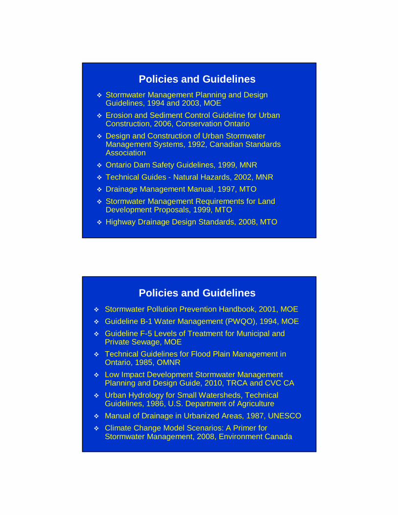
Policies and Guidelines Stormwater Management Planning and Design
Guidelines, 1994 and 2003, MOE Erosion and Sediment Control Guideline for Urban
Construction, 2006, Conservation Ontario Design and Construction of Urban Stormwater
Management Systems, 1992, Canadian Standards Association
Ontario Dam Safety Guidelines, 1999, MNR Technical Guides - Natural Hazards, 2002, MNR Drainage Management Manual, 1997, MTO Stormwater Management Requirements for Land
Development Proposals, 1999, MTO Highway Drainage Design Standards, 2008, MTO
Policies and Guidelines Stormwater Pollution Prevention Handbook, 2001, MOE Guideline B-1 Water Management (PWQO), 1994, MOE Guideline F-5 Levels of Treatment for Municipal and
Private Sewage, MOE Technical Guidelines for Flood Plain Management in
Ontario, 1985, OMNR Low Impact Development Stormwater Management
Planning and Design Guide, 2010, TRCA and CVC CA Urban Hydrology for Small Watersheds, Technical
Guidelines, 1986, U.S. Department of Agriculture Manual of Drainage in Urbanized Areas, 1987, UNESCO Climate Change Model Scenarios: A Primer for
Stormwater Management, 2008, Environment Canada

Roles and Responsibilities for SWM o MOE has the primary lead for water quality and some
aspects of quantity management. o MNR, CAs and MMAH have the primary role for flooding and
riverine erosion control. o Potential for pollution associated with floods and erosion is
of importance to MOE.o MNR and the CAs have strong roles with the water balance,
specifically with groundwater and stream baseflow levels. o MOE’s role becomes prominent with source water protection
and water opportunities & conservation. o MMAH has the primary oversight role for municipal authority
and activities such as municipal SWM.o MAFRA statute pertaining to SW is the Drainage Act, which
directs the planning and maintenance of drainage works.
Design Considerations Every effort should be made to maintain existing watershed
boundaries and drainage patterns Post development peak flow rates must not exceed
corresponding pre-development rates for the 1:2 year through 1:100 year design storm events.
25 mm 4-hour Chicago storm be stored and released over a 24 hour period for erosion control
Quantity control facilities are to be designed in accordance with recommendations set out in MOE Design Guidelines
Standards (and/or design guidelines) established by local municipalities and CA’s should be followed
2-year return period flow should be maintained in the creeks Min. 10mm infiltration (in GTA) should be targeted for new
developments and infill/re-developments.

Design Considerations BMP must be applied to all development in order to provide
enhanced water quality as per the MOE’s Guidelines. Oil and grit separator should be sized properly based on
local rainfall data and may be used as part of a multi-component approach to achieve enhanced quality control.
All major overland flow routes should be sized for the regulatory storm event.
All major overland flow routes are to be transferred (e.g. ownership or easement) to the governing municipality
The SWMF (e.g. wet or dry pond) must be located outside of the 1:100 year floodplain.
All lots should be dry flood-proofed to the regulatory storm elevation in the two-zone flood plain areas.
Design Considerations Regulatory Storm should safely be conveyed through the
development site to a sufficient outlet, such that no adverse impacts will be incurred on up/downstream landowners.
Both the Chicago and the SCS Type II design storm distributions should be modeled to demonstrate peak flow control and calculate required storage volumes
Determine critical storm duration based on peak flow Determine the maximum recommended drainage area for
peak flow calculations using the rational method for sizing storm sewers (rational method vs. hydrologic modeling)
The rainfall time step should be equal to 1/5 of the smallest basin time to peak (tp), where tp = 0.67tc
Appropriate IDF curve should be selected for rainfall data
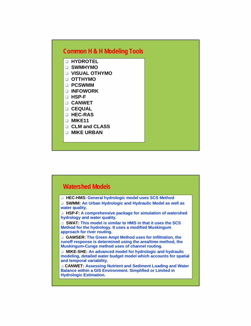
Common H & H Modeling Tools HYDROTEL SWMHYMO VISUAL OTHYMO OTTHYMO PCSWMM INFOWORK HSP-F CANWET CEQUAL HEC-RAS MIKE11 CLM and CLASS MIKE URBAN
Watershed Models HEC-HMS: General hydrologic model uses SCS Method SWMM: An Urban Hydrologic and Hydraulic Model as well as water quality. HSP-F: A comprehensive package for simulation of watershed hydrology and water quality. SWAT: This model is similar to HMS in that it uses the SCS Method for the hydrology. It uses a modified Muskingum approach for river routing. GAWSER: The Green Ampt Method uses for infiltration, the runoff response is determined using the area/time method, the Muskingum-Cunge method uses of channel routing. MIKE-SHE: An advanced model for hydrologic and hydraulic modeling, detailed water budget model which accounts for spatialand temporal variability. CANWET: Assessing Nutrient and Sediment Loading and Water Balance within a GIS Environment. Simplified or Limited in Hydrologic Estimation.

Model Selection Criteria - General The first step is to define the problem and determine what information is
needed and what questions need to be answered. Use the simplest method that can provide the answer to your questions. Use the simplest model that will yield adequate accuracy Do not try to fit the problem to a model, but try to select a model that fits the
problem. Questions whether increased accuracy is worth the increased effort (with the
advances in computer technology, computational cost is hardly an issue anymore).
Do not forget the assumptions underlying the model used and do not read more significance into the simulation results that is actually there.
Data Needs, Watershed Characteristics, Climate Condition, Stakeholder Interest, 1D vs. 2D; Water Budget/WB (Hydrologic Components); Hydrologic vs. Hydraulic, Water Quality, Lumped vs. Distribution, Real Time vs. Off Line.
Event Based vs. Continuous Simulation, Stochastic vs. Deterministic, Modeling Application (Screening, Planning, Design or Operational etc.)
Factors Selecting a Modeling ToolHydrologic Response Units: The modeling approach must be able to assess hydrologic processes associated with land areas sharing soils types, vegetation, physiographic, and land use.Runoff Generation and Routing: The modeling approach uses an appropriate runoff generation and routing method.Snow Accumulation and Snowmelt: Important role in Ontario.Evapotranspiration: vary depending on soil type, vegetation, and climate, and will play a large role in the accuracy of the models especially in evaluating drought scenarios.Infiltration / Soil water / Recharge: Recharge is of prime important in modeling the groundwater system and in particular in obtaining the water supply term for the % water demand calculation.Groundwater / Surface water Interactions: Groundwater plays in important role in sustaining low flows in many streams and rivers as well as assessing ecosystem needs.River Hydraulics and Routing:Flow Regulation: An appropriate modeling approach to represent the effects of flow regulation on model calibration as well as future demand scenarios.Continuous Simulations: Must represent various climate scenarios such as droughts and floods.
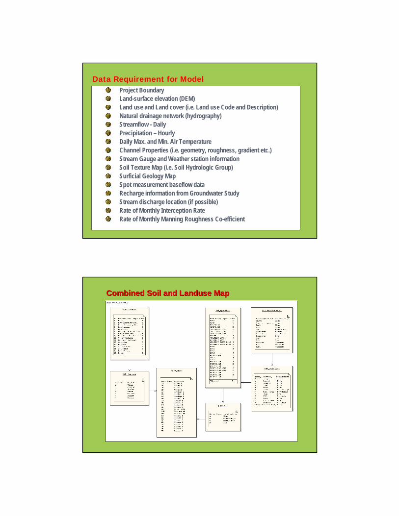
Project Boundary Land-surface elevation (DEM)Land use and Land cover (i.e. Land use Code and Description)Natural drainage network (hydrography) Streamflow - DailyPrecipitation – HourlyDaily Max. and Min. Air Temperature Channel Properties (i.e. geometry, roughness, gradient etc.)Stream Gauge and Weather station informationSoil Texture Map (i.e. Soil Hydrologic Group)Surficial Geology Map Spot measurement baseflow dataRecharge information from Groundwater StudyStream discharge location (if possible)Rate of Monthly Interception RateRate of Monthly Manning Roughness Co-efficient
Data Requirement for Model
Combined Soil and Combined Soil and LanduseLanduse MapMap
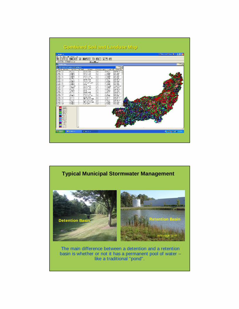
Combined Soil and Combined Soil and LanduseLanduse MapMap
Typical Municipal Stormwater Management
The main difference between a detention and a retention basin is whether or not it has a permanent pool of water –
like a traditional “pond”.
Detention Basin Retention Basin
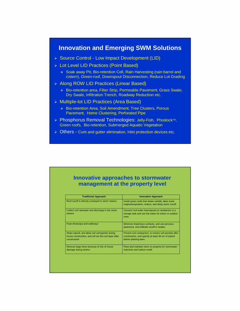
Innovation and Emerging SWM Solutions Source Control - Low Impact Development (LID) Lot Level LID Practices (Point Based)
Soak away Pit, Bio-retention Cell, Rain Harvesting (rain barrel and cistern), Green-roof, Downspout Disconnection, Reduce Lot Grading
Along ROW LID Practices (Linear Based) Bio-retention area, Filter Strip, Permeable Pavement, Grass Swale,
Dry Swale, Infiltration Trench, Roadway Reduction etc.
Multiple-lot LID Practices (Area Based) Bio-retention Area, Soil Amendment, Tree Clusters, Porous
Pavement, Home Clustering, Perforated Pipe
Phosphorus Removal Technologies: Jelly-Fish, PhoslockTM, Green roofs, Bio-retention, Submerged Aquatic Vegetation
Others - Curb and gutter elimination, Inlet protection devices etc.
Traditional Approach Innovative Approach
Roof runoff is directly conveyed to storm sewers Install green roofs that detain rainfall, allow some evapotranspiration, reduce, and delay storm runoff.
Collect roof rainwater and discharge it into storm sewers
Connect roof water downspouts to rainbarrels or a storage tank and use the water for indoor or outdoor uses.
Pave driveways and walkways Minimize impervious surfaces, and use pervious pavement, and infiltrate runoff in swales.
Strips topsoil, and allow soil compaction during house construction, and roll out thin turf layer after construction
Prevent soil compaction, or restore soil porosity after construction, and specify at least 30 cm of topsoil before planting lawn.
Remove large trees because of risk of house damage during storms
Plant and maintain trees on property for stormwater reduction and carbon credit
Innovative approaches to stormwater management at the property level
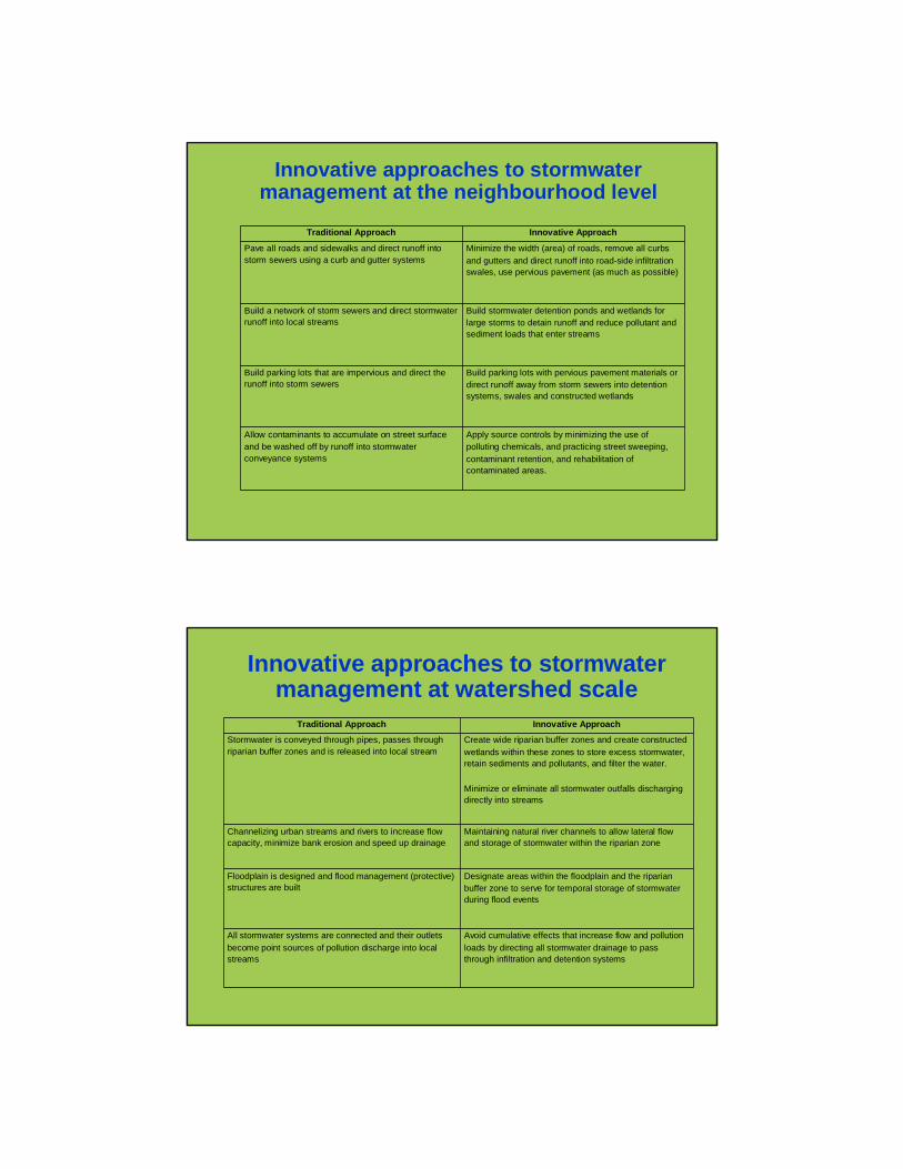
Traditional Approach Innovative Approach
Pave all roads and sidewalks and direct runoff into storm sewers using a curb and gutter systems
Minimize the width (area) of roads, remove all curbs and gutters and direct runoff into road-side infiltration swales, use pervious pavement (as much as possible)
Build a network of storm sewers and direct stormwater runoff into local streams
Build stormwater detention ponds and wetlands for large storms to detain runoff and reduce pollutant and sediment loads that enter streams
Build parking lots that are impervious and direct the runoff into storm sewers
Build parking lots with pervious pavement materials or direct runoff away from storm sewers into detention systems, swales and constructed wetlands
Allow contaminants to accumulate on street surface and be washed off by runoff into stormwater conveyance systems
Apply source controls by minimizing the use of polluting chemicals, and practicing street sweeping, contaminant retention, and rehabilitation of contaminated areas.
Innovative approaches to stormwater management at the neighbourhood level
Traditional Approach Innovative Approach
Stormwater is conveyed through pipes, passes through riparian buffer zones and is released into local stream
Create wide riparian buffer zones and create constructed wetlands within these zones to store excess stormwater, retain sediments and pollutants, and filter the water.
Minimize or eliminate all stormwater outfalls discharging directly into streams
Channelizing urban streams and rivers to increase flow capacity, minimize bank erosion and speed up drainage
Maintaining natural river channels to allow lateral flow and storage of stormwater within the riparian zone
Floodplain is designed and flood management (protective) structures are built
Designate areas within the floodplain and the riparian buffer zone to serve for temporal storage of stormwater during flood events
All stormwater systems are connected and their outlets become point sources of pollution discharge into local streams
Avoid cumulative effects that increase flow and pollution loads by directing all stormwater drainage to pass through infiltration and detention systems
Innovative approaches to stormwater management at watershed scale

Low Impact Development (LID)Principles, Techniques, and Implementation
• What is LID?• Why do we need LID?
• LID Principles
• LID Strategies
• LID Modeling
• LID Implementation
What isLow Impact Development?
• Comprehensive, landscape-based approach to sustainable development
• Set of strategies to maintain existing natural systems, hydrology, ecology
• Cost-effective, flexible approach based on a toolkit of simple techniques
• Collection of practices that have been implemented nationwide
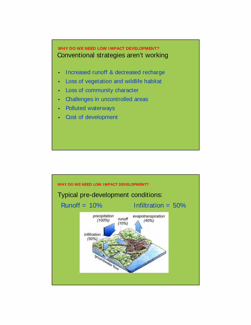
WHY DO WE NEED LOW IMPACT DEVELOPMENT?
Conventional strategies aren’t working
• Increased runoff & decreased recharge
• Loss of vegetation and wildlife habitat
• Loss of community character
• Challenges in uncontrolled areas
• Polluted waterways
• Cost of development
WHY DO WE NEED LOW IMPACT DEVELOPMENT?
Typical pre-development conditions:
Runoff = 10% Infiltration = 50%
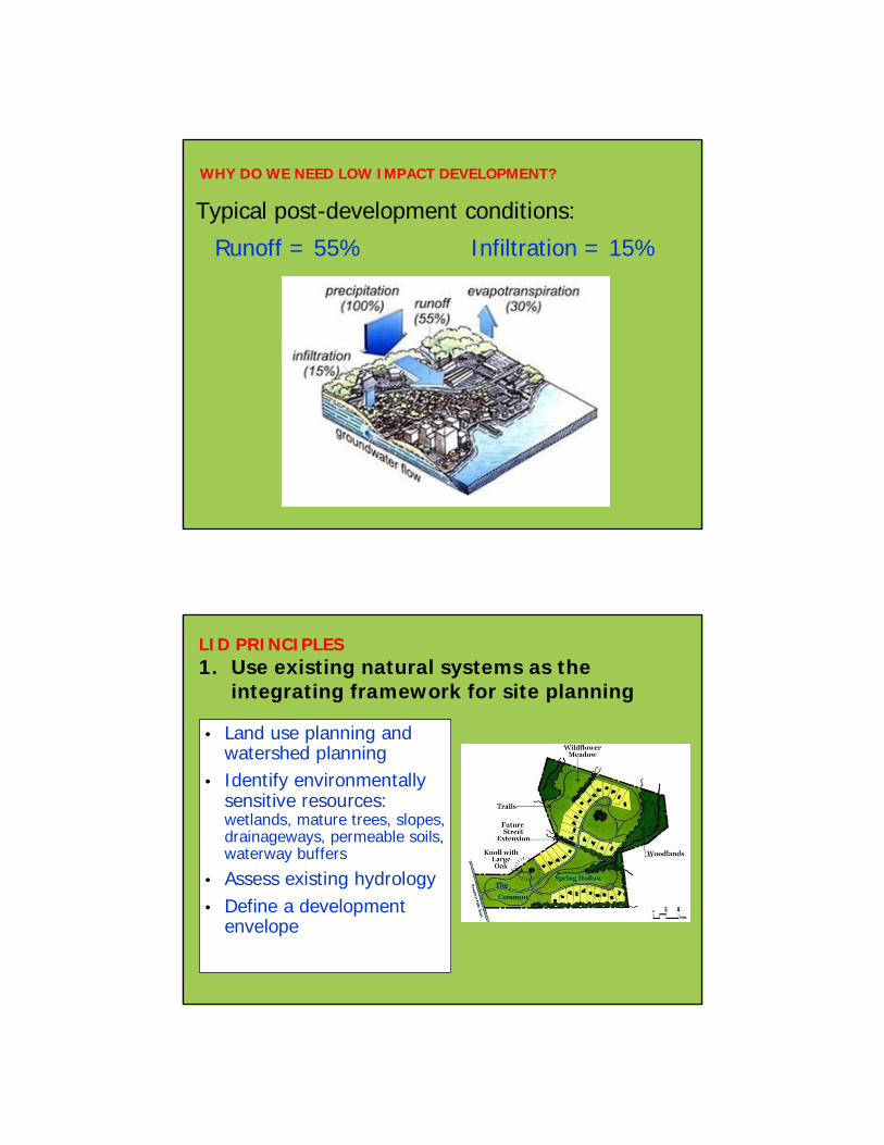
WHY DO WE NEED LOW IMPACT DEVELOPMENT?
Typical post-development conditions:
Runoff = 55% Infiltration = 15%
LID PRINCIPLES1. Use existing natural systems as the
integrating framework for site planning
• Land use planning and watershed planning
• Identify environmentally sensitive resources: wetlands, mature trees, slopes, drainageways, permeable soils, waterway buffers
• Assess existing hydrology• Define a development
envelope
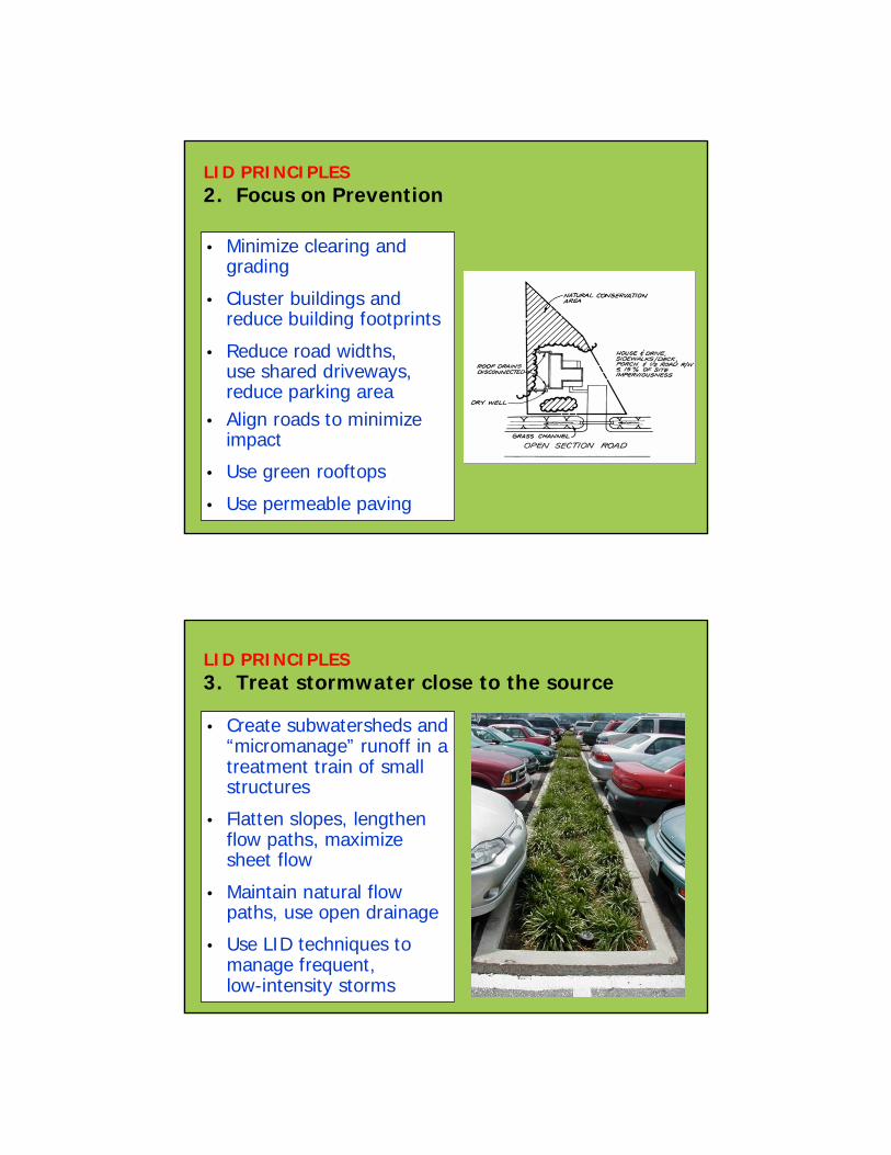
LID PRINCIPLES2. Focus on Prevention
• Minimize clearing and grading
• Cluster buildings and reduce building footprints
• Reduce road widths, use shared driveways, reduce parking area
• Align roads to minimize impact
• Use green rooftops
• Use permeable paving
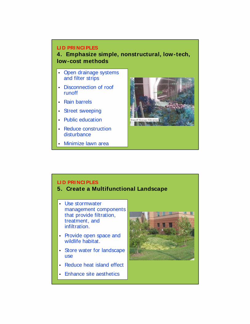
LID PRINCIPLES3. Treat stormwater close to the source
• Create subwatersheds and “micromanage” runoff in a treatment train of small structures
• Flatten slopes, lengthen flow paths, maximize sheet flow
• Maintain natural flow paths, use open drainage
• Use LID techniques to manage frequent, low-intensity storms
• Open drainage systems and filter strips
• Disconnection of roof runoff
• Rain barrels
• Street sweeping
• Public education
• Reduce construction disturbance
• Minimize lawn area
LID PRINCIPLES4. Emphasize simple, nonstructural, low-tech, low-cost methods
• Use stormwater management components that provide filtration, treatment, and infiltration.
• Provide open space and wildlife habitat.
• Store water for landscape use
• Reduce heat island effect
• Enhance site aesthetics
LID PRINCIPLES5. Create a Multifunctional Landscape
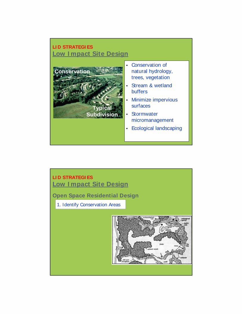
LID STRATEGIESLow Impact Site Design
• Conservation of natural hydrology, trees, vegetation
• Stream & wetland buffers
• Minimize impervious surfaces
• Stormwater micromanagement
• Ecological landscaping
Typical Subdivision
Conservation
LID STRATEGIESLow Impact Site Design
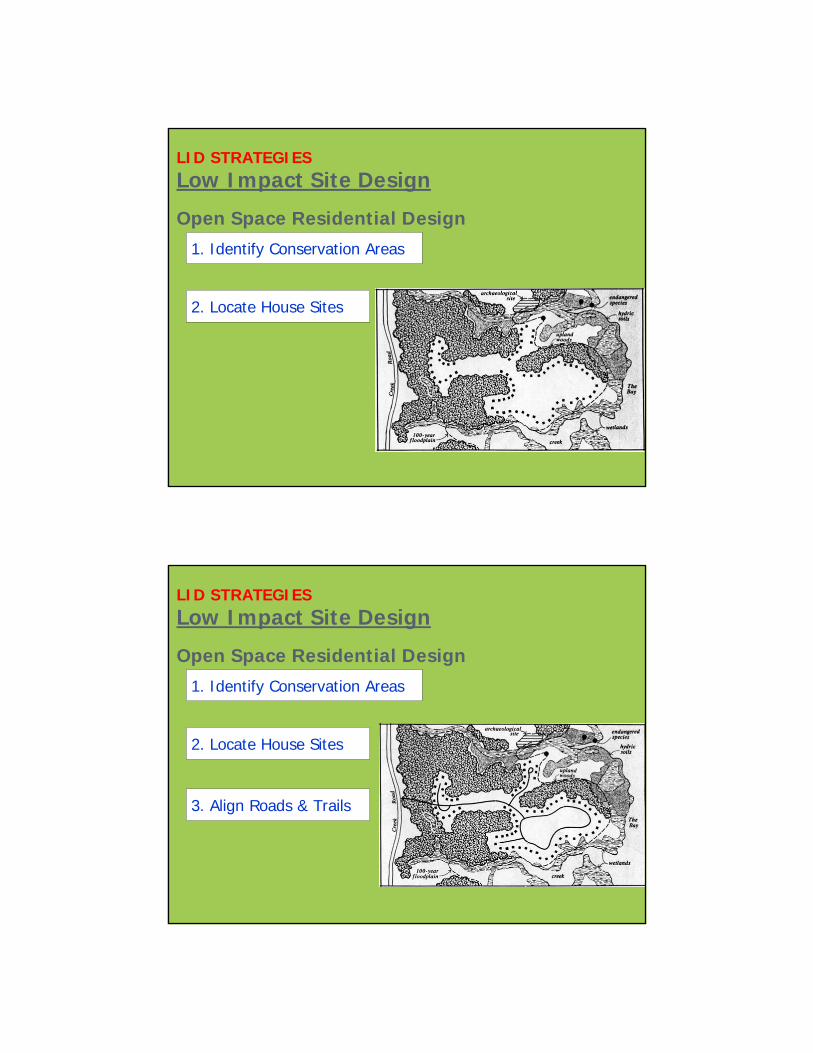
Open Space Residential Design
1. Identify Conservation Areas
LID STRATEGIESLow Impact Site Design
Open Space Residential Design
1. Identify Conservation Areas
2. Locate House Sites
LID STRATEGIESLow Impact Site Design
Open Space Residential Design
1. Identify Conservation Areas
2. Locate House Sites
3. Align Roads & Trails
1. Identify Conservation Areas
2. Locate House Sites
3. Align Roads & Trails
4. Draw the Lot Lines
Open Space Residential Design
LID STRATEGIESLow Impact Site Design
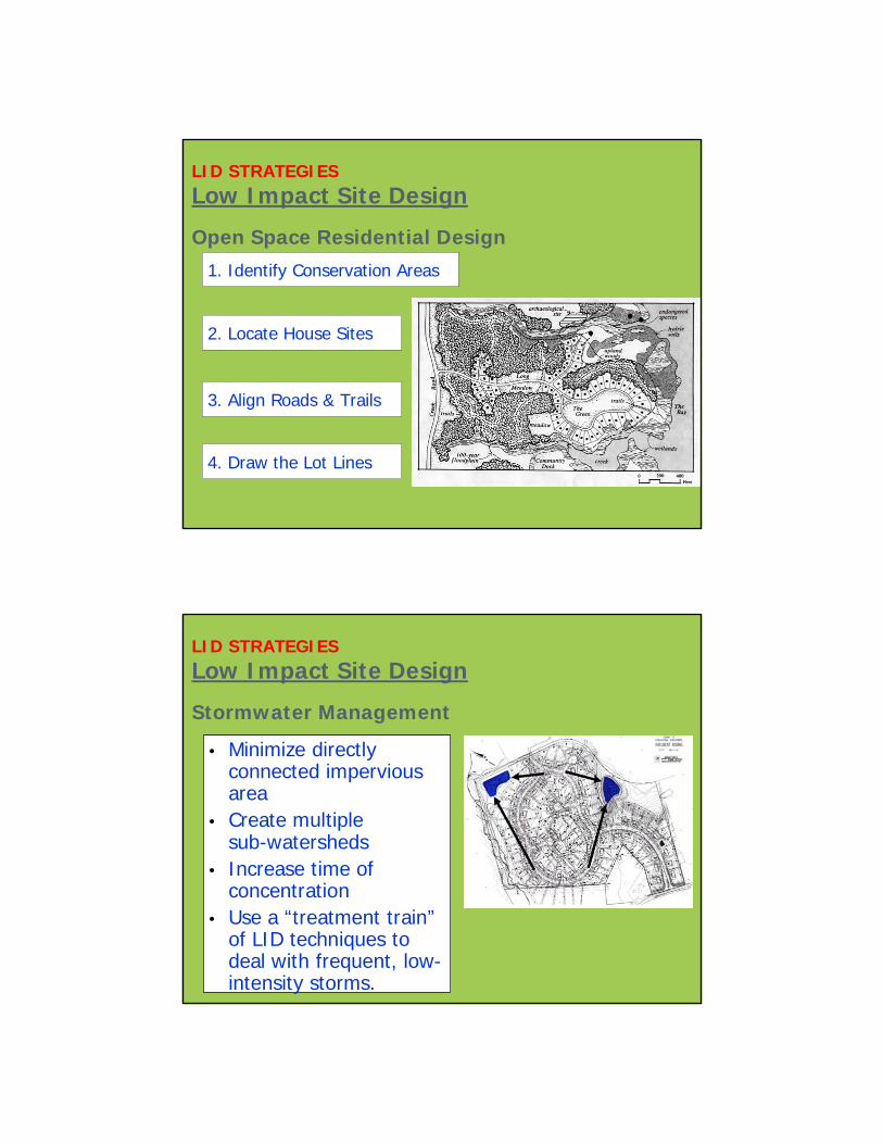
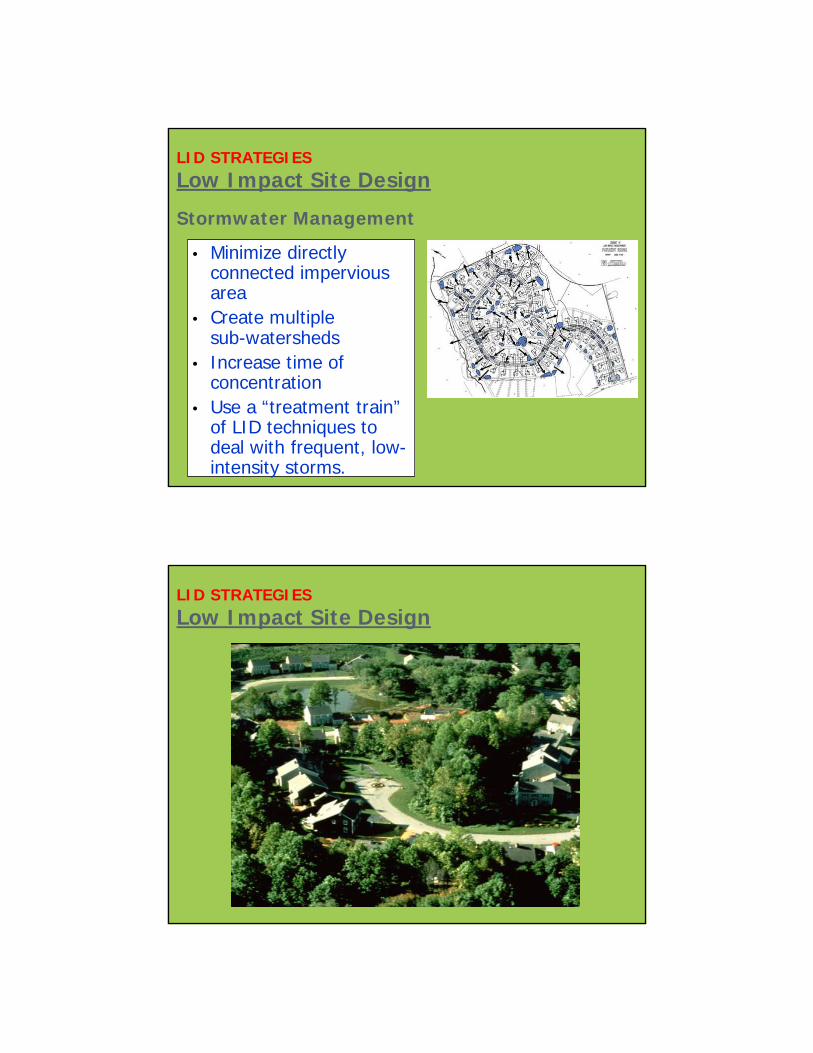
Stormwater Management
LID STRATEGIESLow Impact Site Design
• Minimize directly connected impervious area
• Create multiple sub-watersheds
• Increase time of concentration
• Use a “treatment train”of LID techniques to deal with frequent, low-intensity storms.
Stormwater Management
LID STRATEGIESLow Impact Site Design
• Minimize directly connected impervious area
• Create multiple sub-watersheds
• Increase time of concentration
• Use a “treatment train”of LID techniques to deal with frequent, low-intensity storms.
LID STRATEGIESLow Impact Site Design
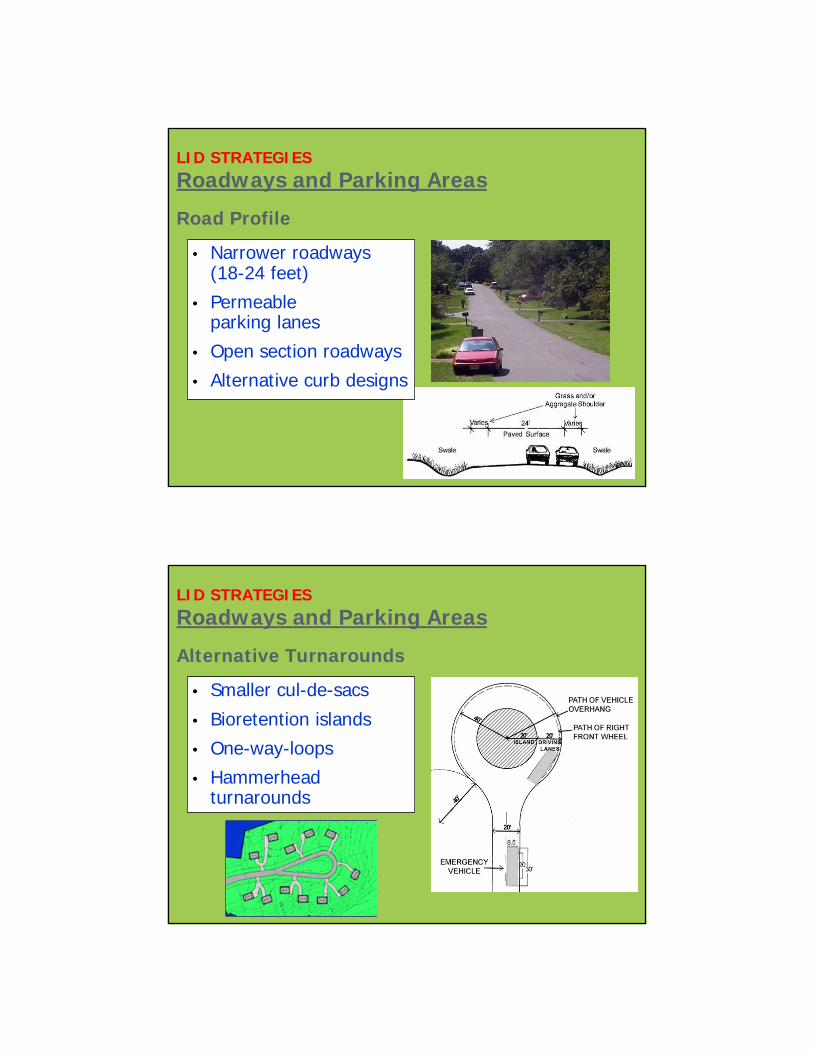
LID STRATEGIESRoadways and Parking Areas
Road Profile
• Narrower roadways (18-24 feet)
• Permeable parking lanes
• Open section roadways
• Alternative curb designs
LID STRATEGIESRoadways and Parking Areas
Alternative Turnarounds
• Smaller cul-de-sacs
• Bioretention islands
• One-way-loops
• Hammerhead turnarounds
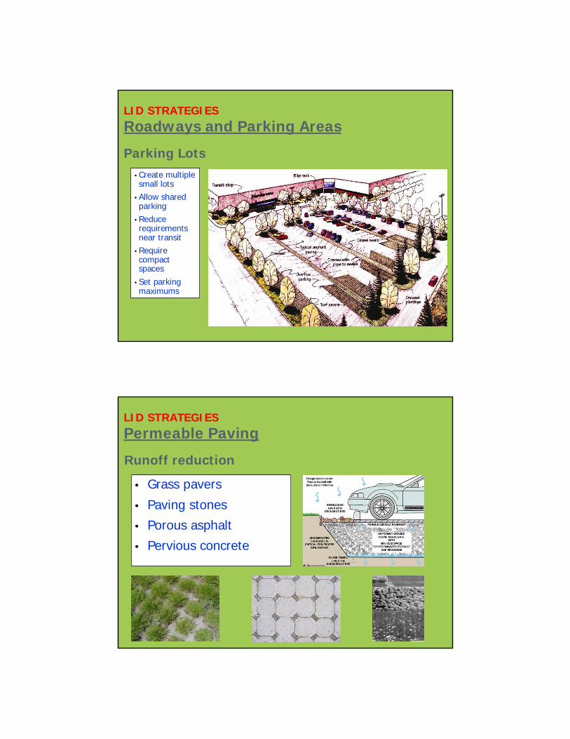
LID STRATEGIESRoadways and Parking Areas
Parking Lots• Create multiple small lots
• Allow shared parking
• Reduce requirements near transit
• Require compact spaces
• Set parking maximums
LID STRATEGIESPermeable Paving
• Grass pavers
• Paving stones
• Porous asphalt
• Pervious concrete
Runoff reduction
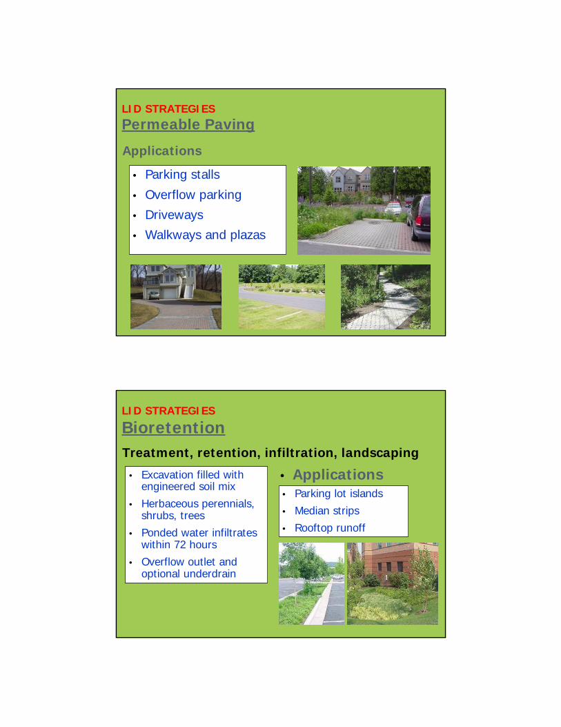
LID STRATEGIESPermeable Paving
• Parking stalls
• Overflow parking
• Driveways
• Walkways and plazas
Applications
LID STRATEGIES
Bioretention
• Excavation filled with engineered soil mix
• Herbaceous perennials, shrubs, trees
• Ponded water infiltrates within 72 hours
• Overflow outlet and optional underdrain
Treatment, retention, infiltration, landscaping
• Parking lot islands
• Median strips
• Rooftop runoff
• Applications
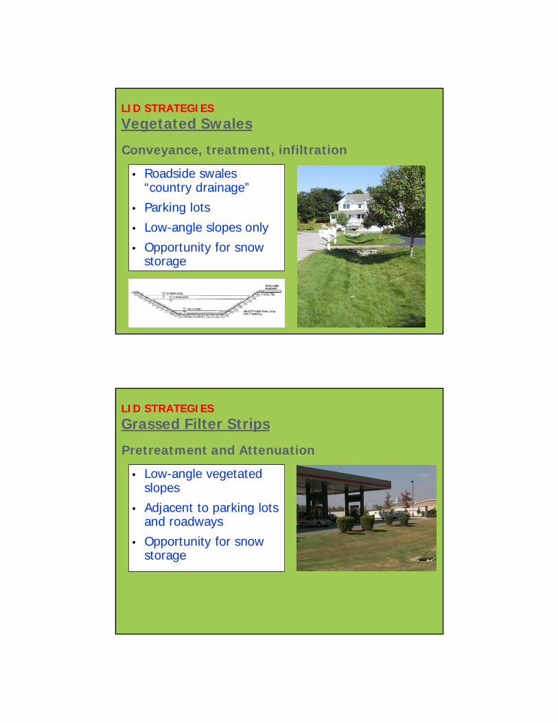
LID STRATEGIESVegetated Swales
• Roadside swales “country drainage”
• Parking lots
• Low-angle slopes only
• Opportunity for snow storage
Conveyance, treatment, infiltration
LID STRATEGIESGrassed Filter Strips
Pretreatment and Attenuation
• Low-angle vegetated slopes
• Adjacent to parking lots and roadways
• Opportunity for snow storage
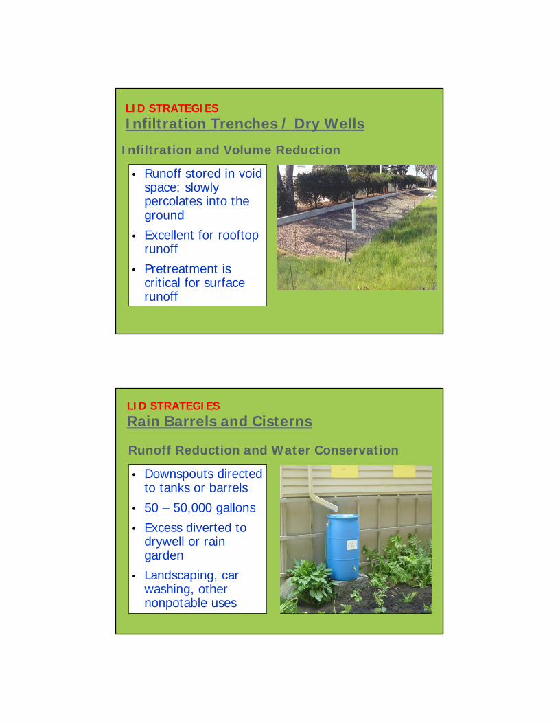
LID STRATEGIESInfiltration Trenches / Dry Wells
Infiltration and Volume Reduction
• Runoff stored in void space; slowly percolates into the ground
• Excellent for rooftop runoff
• Pretreatment is critical for surface runoff
Runoff Reduction and Water Conservation
LID STRATEGIESRain Barrels and Cisterns
• Downspouts directed to tanks or barrels
• 50 – 50,000 gallons
• Excess diverted to drywell or rain garden
• Landscaping, car washing, other nonpotable uses

Runoff Reduction, Reduce Heating/Cooling Costs
LID STRATEGIESGreen Roof Systems
• Rainwater stored in a lightweight engineered soil medium
• Hardy, drought-resistant vegetation
• Reduce runoff by 50%
• Not for use in stressed basins
Runoff Reduction, Treatment, Attenuation
LID STRATEGIESStormwater Planters
• “Bioretention in a Box”• Vegetative uptake of
stormwater pollutants• Pretreatment for
suspended solids• Aesthetically pleasing• Reduction of peak
discharge rate
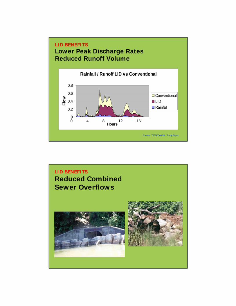
LID BENEFITSLower Peak Discharge Rates Reduced Runoff Volume
Rainfall / Runoff LID vs Conventional
0
0.2
0.4
0.6
0.8
Hours
Flow
ConventionalLIDRainfall
0 4 8 12 16
Source: TRCA/CA Ont. Study Paper
LID BENEFITS
Reduced Combined Sewer Overflows

LID IMPLEMENTATION
Important Considerations
• Select appropriate cold climate techniques
• Ensure adequate emergency access
• Prioritize pedestrian safety
• Define ownership: public, private, mix?
• Require monitoring and inspection
• Assign maintenance responsibilities
LID MODELING TOOLSImportant Considerations• Event to Continuous Simulation (Temporal)
• Temporal Resolution – Seconds to Minutes
• Lot Level to Watershed Scale (Spatial)• Example of LID Modeling Tools:
SWMM ver. 5.0 (EPA) – Atmospheric, Land Surface, Groundwater, Transport Compartment
MUSIC ver. 3.0 (AUS) – Catchment, Sources Node, Junction Nodes, Treatment Nodes, Treatment Devices, and Drainage Link etc.
MOUSE (DHI)- Runoff Module, HD Module, RDII Module, RTC Module, TRAP Module
BMPDSS ver. 1.0 (USA) – ArcGIS Interface, BMP Simulation, Routing/Transport Module, Optimization Component, Post-processor
SUSTAIN (EPA) – ArcGIS , MS Access Database Module, Watershed Module, BMP Module, Post-processor, Optimization Module etc.
HydroCAD, STORM, WBM, InfoWork CS ver. 9.5, etc
Guiding Principles for SWM Reduce the interference of the natural water cycle by
building urban communities that better mimic the natural water cycle.
Reuse stormwater for the same (e.g. watering landscape) or another purpose (e.g. toilet flushing).
Recycle stormwater back into the natural water cycle by infiltration or by release to surface water (e.g. recharge).
Stormwater is a resource asset. It is not just as a flood water risk that must be expediently removed from properties. A fundamental shift in attitude is needed to support water conservation.
Establish source control for existing developed areas, not just new developments.
Climate change adaptation decision for SWM is required immediately based on best available science.
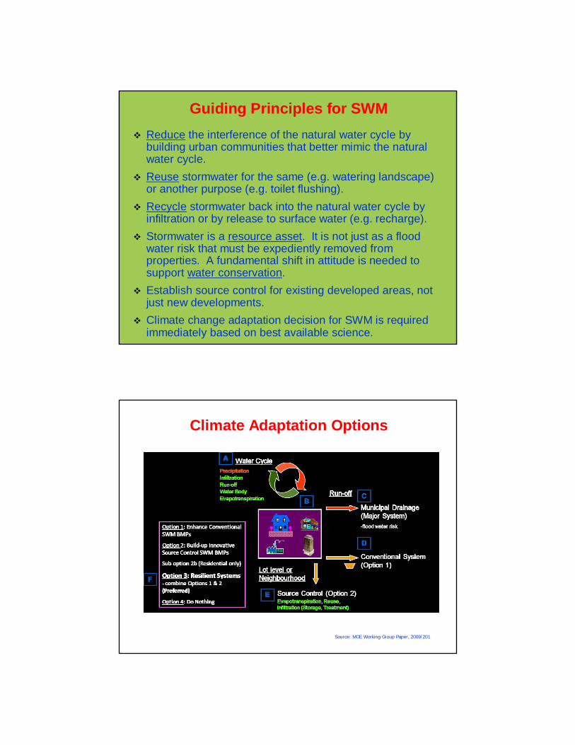
Climate Adaptation Options
Source: MOE Working Group Paper, 2009/201
Future Direction and Policy Outline Establish Resilient Systems that include source control (lot,
neighborhood) and conventional SWM. Applies to new and existing developments, with phase-in
periods.
Has simple source control targets for municipal or public monitoring of progress.
Encourage municipalities to develop long term SWM master plans.
Guidance could be established for climate change adaptation allowance for sizing of source control or conventional SWM systems.
based on engineering design, build 15% bigger, install next size pipe, use 5 year storm design instead of 2 year, use 10 year storm design instead of 5 year, or use updated Intensity-Duration-Frequency (IDF) curve
Future Direction and Policy Outline Reduce, Reuse and Recycle for stormwater. Recognize stormwater as a resource asset. Conserve municipal water use through stormwater reuse. Develop SWM systems that are resilient and adaptive to
climate change. Support immediate climate change adaptation decisions
based on best available science, such as SWM system sizing adaptation allowance.
Reduce impact on the natural water cycle and recharge groundwater.
Reduce impact on receiving water quality and aquatic ecosystem health, including cumulative impact on receiving water quality and environmental monitoring.