Embed Size (px)
Citation preview
PERS Isle of Man Study 25/06/2018
Reference number 107976
PERS STUDY, ISLE OF MAN
PERS – SUMMARY REPORT
PERS STUDY ON THE ISLE OF MAN PERS – SUMMARY REPORT
IDENTIFICATION TABLE
Client/Project owner Isle of Man
Project PERS study on the Isle of Man
Type of document PERS Summary Report
Date 25/06/2019
Reference number 107976
Number of pages 52
Approval
Version Name Position Date Modifications
1
Author Jeeves Saini Assistant Consultant
19/03/19
1st draft for client review
Checked by Sian Fox Principal Consultant
26/03/19
Approved by
Sian Fox Principal Consultant
27/03/19
PERS Audit – Summary Report 21/01/2018
CONTENTS
1. INTRODUCTION 4
2. PERS AUDIT 6
2.1 SURVEY METHODOLOGY AND SCOPE 6
2.2 LINKS 6 CONSISTENT SIMILARITIES IN THE LINKS 6 CONSISTENT NEGATIVES IN THE LINKS 8 HIGHEST SCORING SETTLEMENTS 9 ONCHAN 10 DOUGLAS 10 UNION MILLS & STRANG 11 LOWEST SCORING SETTLEMENTS 12 SULBY 12 BALDRINE 14 LAXEY 15 HEALTH 16 EDUCATION 19 LOCAL CENTRES 22 COMPARING THE PERS ON THE ISLE OF MAN WITH OTHER PERS COMPLETED 24 VALUING URBAN REALM TOOLKIT 25
2.3 CONCLUSION AND RECOMMENDATIONS 26 APPENDIX A - LINK SCORES 27
1. INTRODUCTION
1.1 General
1.1.1 SYSTRA Ltd (SYSTRA) has been commissioned by Highway Services, Department of Infrastructure, Isle of Man Government (‘the Client’) to undertake PERS audits for the settlements across the Isle of Man shown in Figure 1.
1.1.2 The client is undertaking an assessment of the coherence of the highway network for all users, and there is a requirement to obtain evidence relating to the pedestrian network, in order to support the decision-making process. The PERS audits will provide a key piece of the evidence base.
1.1.3 17 reports were produced with a particular focus on people’s access to facilities and services including:
Health (health) Schools (education) Local centres (economy)
1.1.4 Each of these 17 reports focuses on one of the PERS audit sites listed in Figure 1, outlining the links, their scores, and mapping the settlement to display the link scores and allow for easy identification of areas of poor links so these can be prioritised. Each report also identifies areas where there is no footpath present on links we assessed. This information can be utilised to identify where larger scale infrastructure provision is required.
1.1.5 This report provides a summary of the audits undertaken across the island followed by conclusions regarding the quality and condition of the current pedestrian environments as a whole and recommendations for future action and initiatives.
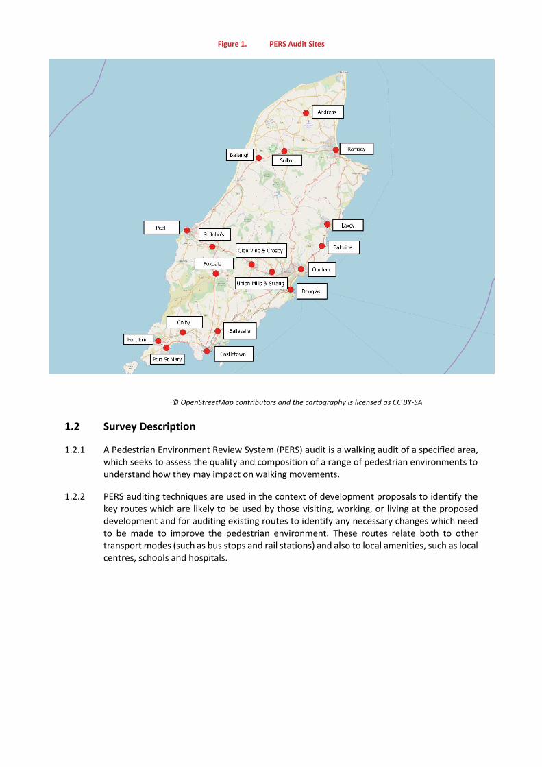
Figure 1. PERS Audit Sites
© OpenStreetMap contributors and the cartography is licensed as CC BY-SA
1.2 Survey Description
1.2.1 A Pedestrian Environment Review System (PERS) audit is a walking audit of a specified area, which seeks to assess the quality and composition of a range of pedestrian environments to understand how they may impact on walking movements.
1.2.2 PERS auditing techniques are used in the context of development proposals to identify the key routes which are likely to be used by those visiting, working, or living at the proposed development and for auditing existing routes to identify any necessary changes which need to be made to improve the pedestrian environment. These routes relate both to other transport modes (such as bus stops and rail stations) and also to local amenities, such as local centres, schools and hospitals.
2. PERS AUDIT
2.1 Survey Methodology and Scope
2.1.1 PERS-style audits were conducted between 15th October 2018 and 22nd May 2019. The audit is designed to assess the existing pedestrian environment and give the infrastructure a score from -3 to +3, using a standardised assessment criteria which has been developed for this purpose. Links (footways), were assessed as part of the audit.
2.1.2 This PERS-style audit was undertaken using the Transport Research Laboratory (TRL) PERS Checklist, which includes criteria relating to performance, environmental context and perception of the respective link, public transport waiting area and crossing. These checklists form the basis of this PERS-style audit and are recommended for use by both TfL and most London boroughs.
2.1.3 All pedestrian footways within the scope area were surveyed on foot, and therefore this ensured that any clear faults within the local environment were identified within the audit. As a result of this process, the location of nearby amenities were identified and some commentary on the quality of the routes to these is provided later in this report.
2.2 Links
2.2.1 A total of 523 links were assessed across all settlements; the overall weighted scores for each of these have been colour coded relative to performance and provided in Appendix A.
Consistent Positives in the Links
2.2.2 Certain factors were common amongst the sites audited across the island. Coastal and central parts of larger towns such as Ramsey and Douglas provide opportunities for leisure and shopping and so often tend to score highly i.e. above “Average.” The need to accommodate greater volumes of pedestrians in a recreational setting has been taken into account to provide suitable, functional and aesthetic environments. These areas boast wide footpaths with high surface quality, pedestrianised and vehicle-restricted areas, and a developed sense of place. Prime examples of this include both the North Quay and Strand Street in Douglas and Parliament Street in Ramsey as shown in Figures 2 and 3 overleaf.
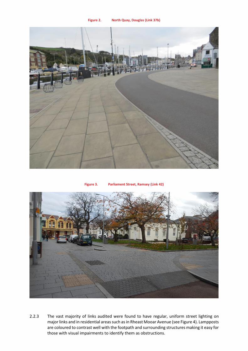
Figure 2. North Quay, Douglas (Link 37b)
Figure 3. Parliament Street, Ramsey (Link 42)
2.2.3 The vast majority of links audited were found to have regular, uniform street lighting on major links and in residential areas such as in Rheast Mooar Avenue (see Figure 4). Lampposts are coloured to contrast well with the footpath and surrounding structures making it easy for those with visual impairments to identify them as obstructions.
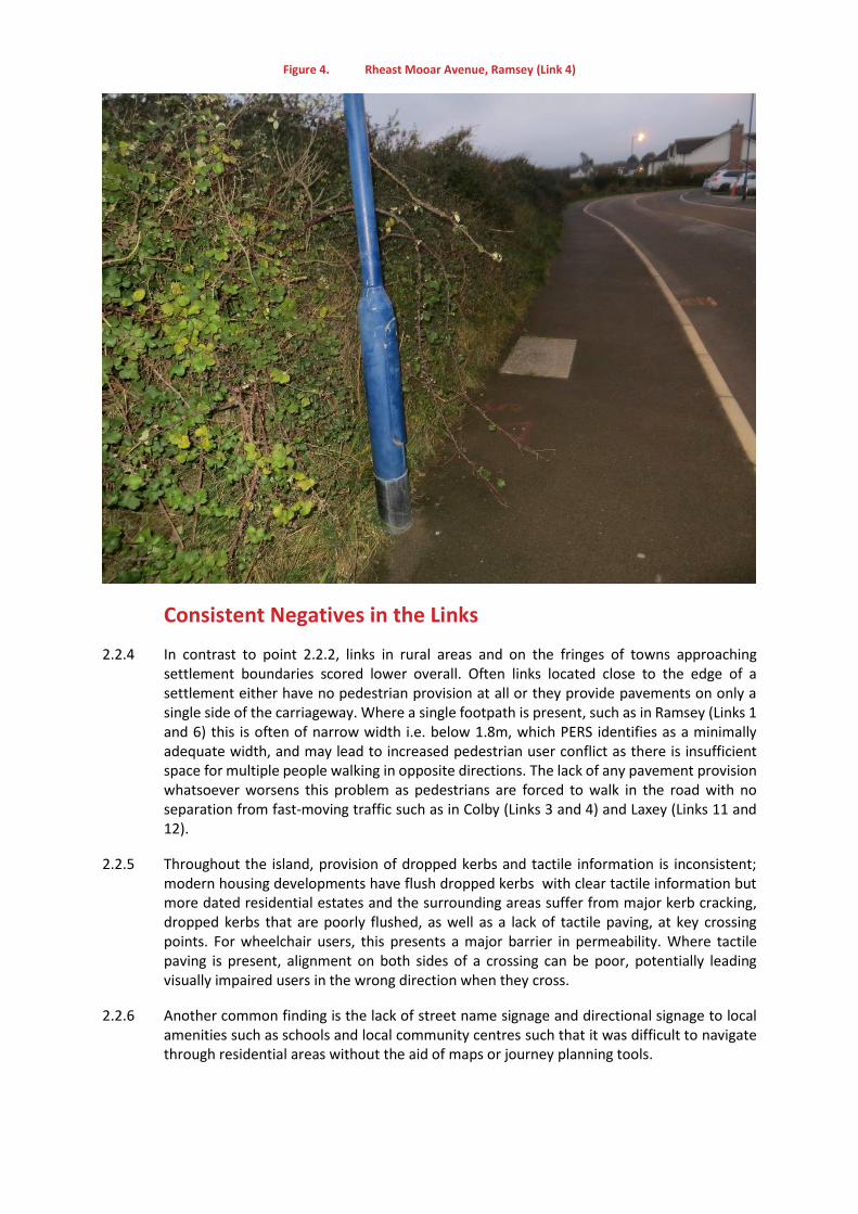
Figure 4. Rheast Mooar Avenue, Ramsey (Link 4)
Consistent Negatives in the Links
2.2.4 In contrast to point 2.2.2, links in rural areas and on the fringes of towns approaching settlement boundaries scored lower overall. Often links located close to the edge of a settlement either have no pedestrian provision at all or they provide pavements on only a single side of the carriageway. Where a single footpath is present, such as in Ramsey (Links 1 and 6) this is often of narrow width i.e. below 1.8m, which PERS identifies as a minimally adequate width, and may lead to increased pedestrian user conflict as there is insufficient space for multiple people walking in opposite directions. The lack of any pavement provision whatsoever worsens this problem as pedestrians are forced to walk in the road with no separation from fast-moving traffic such as in Colby (Links 3 and 4) and Laxey (Links 11 and 12).
2.2.5 Throughout the island, provision of dropped kerbs and tactile information is inconsistent; modern housing developments have flush dropped kerbs with clear tactile information but more dated residential estates and the surrounding areas suffer from major kerb cracking, dropped kerbs that are poorly flushed, as well as a lack of tactile paving, at key crossing points. For wheelchair users, this presents a major barrier in permeability. Where tactile paving is present, alignment on both sides of a crossing can be poor, potentially leading visually impaired users in the wrong direction when they cross.
2.2.6 Another common finding is the lack of street name signage and directional signage to local amenities such as schools and local community centres such that it was difficult to navigate through residential areas without the aid of maps or journey planning tools.
Highest Scoring settlements
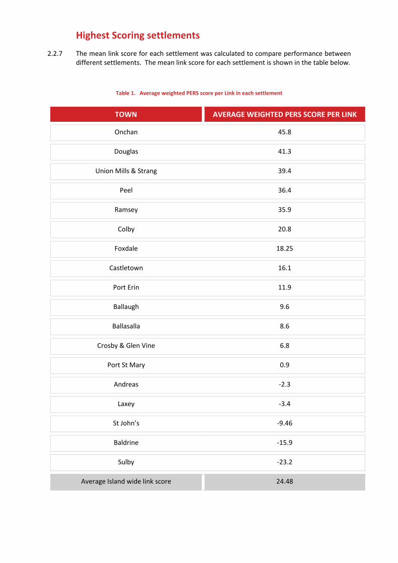
2.2.7 The mean link score for each settlement was calculated to compare performance between different settlements. The mean link score for each settlement is shown in the table below.
Table 1. Average weighted PERS score per Link in each settlement
TOWN AVERAGE WEIGHTED PERS SCORE PER LINK
Onchan 45.8
Douglas 41.3
Union Mills & Strang 39.4
Peel 36.4
Ramsey 35.9
Colby 20.8
Foxdale 18.25
Castletown 16.1
Port Erin 11.9
Ballaugh 9.6
Ballasalla 8.6
Crosby & Glen Vine 6.8
Port St Mary 0.9
Andreas -2.3
Laxey -3.4
St John’s -9.46
Baldrine -15.9
Sulby -23.2
Average Island wide link score 24.48
Onchan
2.2.8 With only 14 out of 70 links scored as “Poor” or “Very Poor,” Onchan was found to have the highest average weighted link score of 45.8. If the audited links are representative of the wider settlements, this indicates that Onchan had the best pedestrian provision of all audited settlements.
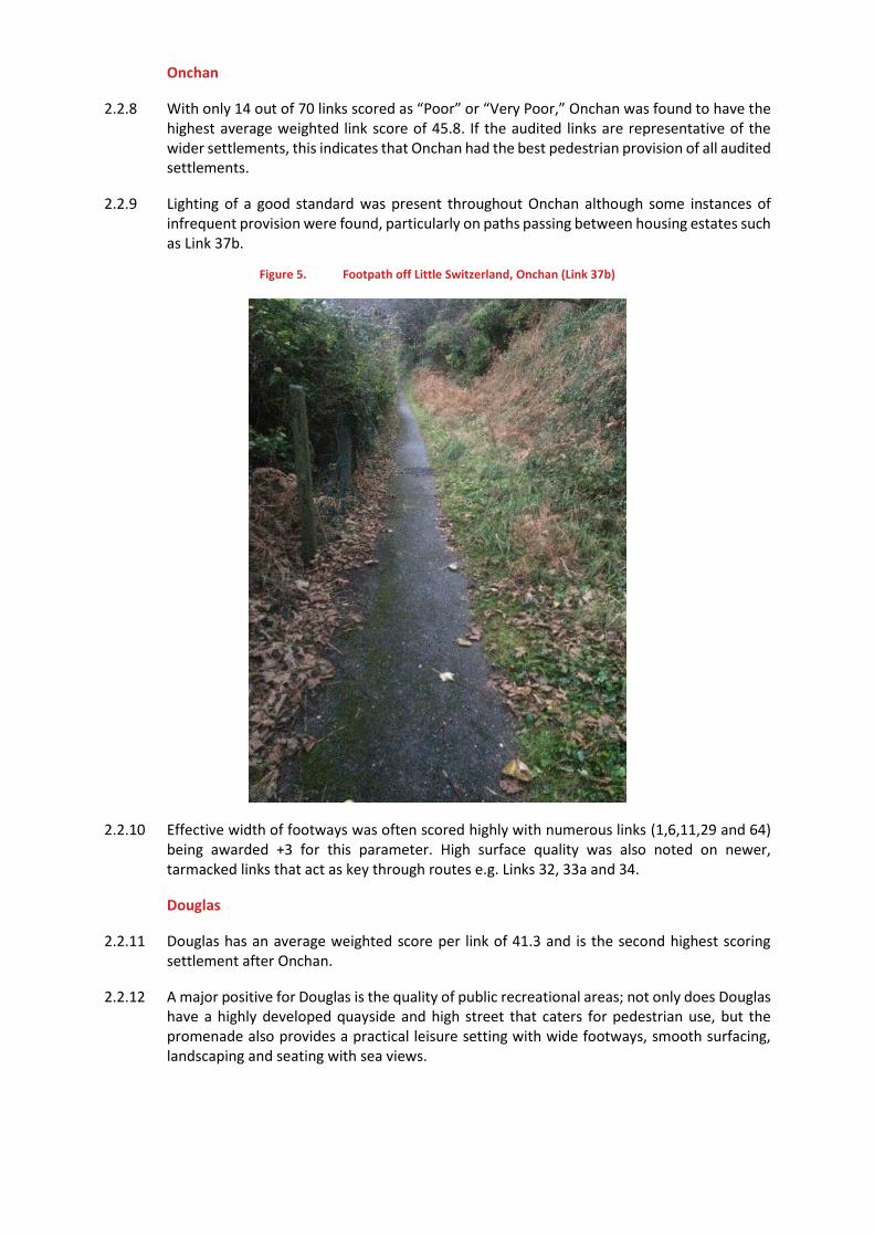
2.2.9 Lighting of a good standard was present throughout Onchan although some instances of infrequent provision were found, particularly on paths passing between housing estates such as Link 37b.
Figure 5. Footpath off Little Switzerland, Onchan (Link 37b)
2.2.10 Effective width of footways was often scored highly with numerous links (1,6,11,29 and 64) being awarded +3 for this parameter. High surface quality was also noted on newer, tarmacked links that act as key through routes e.g. Links 32, 33a and 34.
Douglas
2.2.11 Douglas has an average weighted score per link of 41.3 and is the second highest scoring settlement after Onchan.
2.2.12 A major positive for Douglas is the quality of public recreational areas; not only does Douglas have a highly developed quayside and high street that caters for pedestrian use, but the promenade also provides a practical leisure setting with wide footways, smooth surfacing, landscaping and seating with sea views.
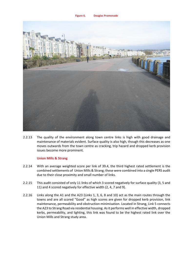
Figure 6. Douglas Promenade
2.2.13 The quality of the environment along town centre links is high with good drainage and maintenance of materials evident. Surface quality is also high, though this decreases as one moves outwards from the town centre as cracking, trip hazard and dropped kerb provision issues become more prominent.
Union Mills & Strang
2.2.14 With an average weighted score per link of 39.4, the third highest rated settlement is the combined settlements of Union Mills & Strang; these were combined into a single PERS audit due to their close proximity and small number of links.
2.2.15 This audit consisted of only 11 links of which 3 scored negatively for surface quality (3, 5 and 11) and 4 scored negatively for effective width (2, 4, 7 and 9).
2.2.16 Links along the A1 and the A23 (Links 1, 3, 6, 8 and 10) act as the main routes through the towns and are all scored “Good” as high scores are given for dropped kerb provision, link maintenance, permeability and obstruction minimisation. Located in Strang, Link 5 connects the A23 to Strang Road via residential housing. As it performs well in effective width, dropped kerbs, permeability, and lighting, this link was found to be the highest rated link over the Union Mills and Strang study area.
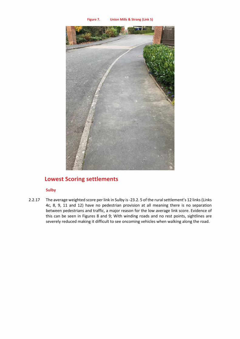
Figure 7. Union Mills & Strang (Link 5)
Lowest Scoring settlements
Sulby
2.2.17 The average weighted score per link in Sulby is -23.2. 5 of the rural settlement’s 12 links (Links 4c, 8, 9, 11 and 12) have no pedestrian provision at all meaning there is no separation between pedestrians and traffic, a major reason for the low average link score. Evidence of this can be seen in Figures 8 and 9; With winding roads and no rest points, sightlines are severely reduced making it difficult to see oncoming vehicles when walking along the road.
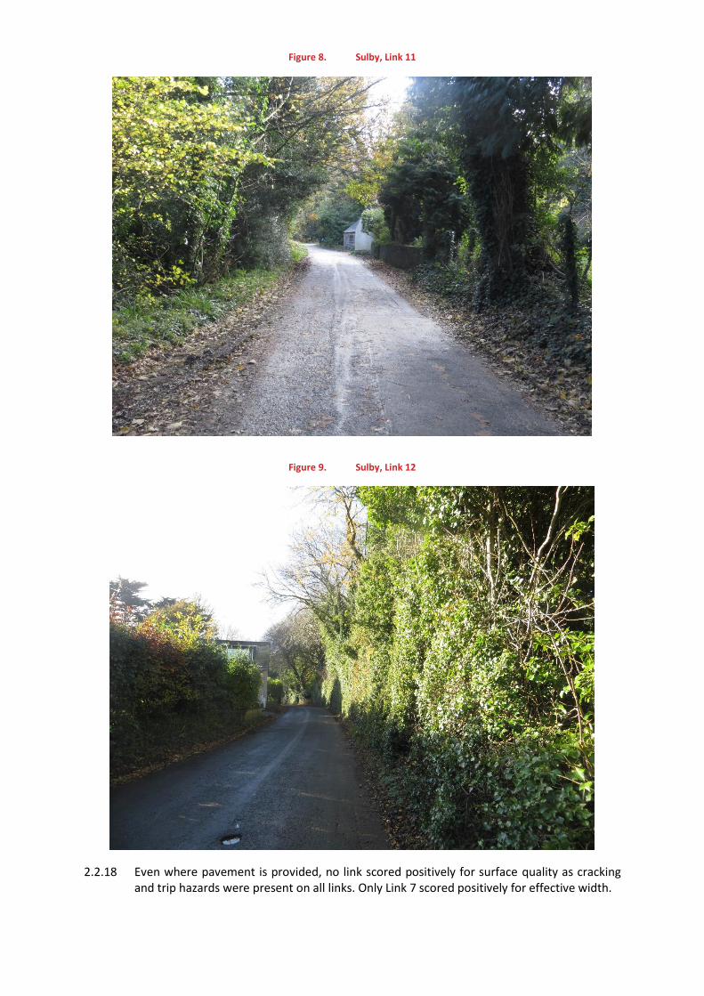
Figure 8. Sulby, Link 11
Figure 9. Sulby, Link 12
2.2.18 Even where pavement is provided, no link scored positively for surface quality as cracking and trip hazards were present on all links. Only Link 7 scored positively for effective width.
Baldrine
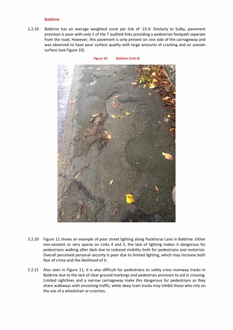
2.2.19 Baldrine has an average weighted score per link of -15.9. Similarly to Sulby, pavement provision is poor with only 1 of the 7 audited links providing a pedestrian footpath separate from the road. However, this pavement is only present on one side of the carriageway and was observed to have poor surface quality with large amounts of cracking and an uneven surface (see Figure 10).
Figure 10. Baldrine (Link 4)
2.2.20 Figure 11 shows an example of poor street lighting along Packhorse Lane in Baldrine. Either non-existent or very sparse on Links 4 and 5, the lack of lighting makes it dangerous for pedestrians walking after dark due to reduced visibility both for pedestrians and motorists. Overall perceived personal security is poor due to limited lighting, which may increase both fear of crime and the likelihood of it.
2.2.21 Also seen in Figure 11, it is also difficult for pedestrians to safely cross tramway tracks in Baldrine due to the lack of clear ground markings and pedestrian provision to aid in crossing. Limited sightlines and a narrow carriageway make this dangerous for pedestrians as they share walkways with oncoming traffic, while deep tram tracks may inhibit those who rely on the use of a wheelchair or crutches.
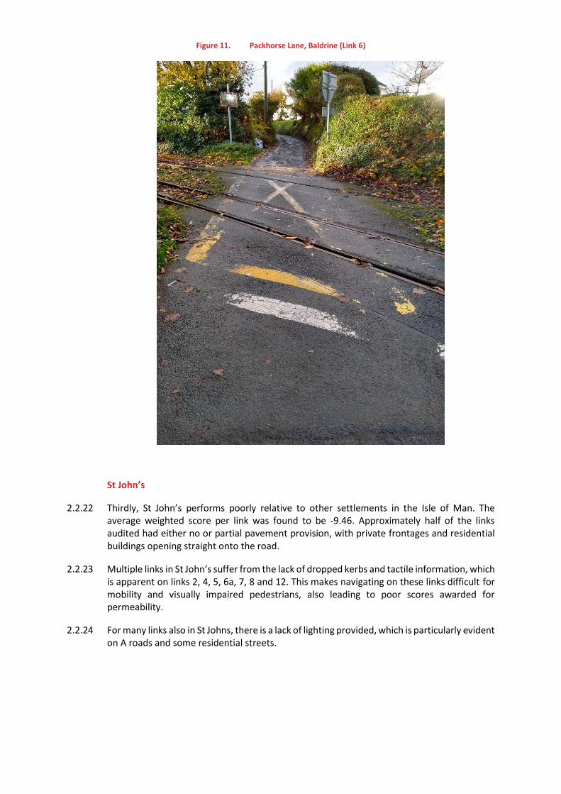
Figure 11. Packhorse Lane, Baldrine (Link 6)
St John’s
2.2.22 Thirdly, St John’s performs poorly relative to other settlements in the Isle of Man. The average weighted score per link was found to be -9.46. Approximately half of the links audited had either no or partial pavement provision, with private frontages and residential buildings opening straight onto the road.
2.2.23 Multiple links in St John’s suffer from the lack of dropped kerbs and tactile information, which is apparent on links 2, 4, 5, 6a, 7, 8 and 12. This makes navigating on these links difficult for mobility and visually impaired pedestrians, also leading to poor scores awarded for permeability.
2.2.24 For many links also in St Johns, there is a lack of lighting provided, which is particularly evident on A roads and some residential streets.
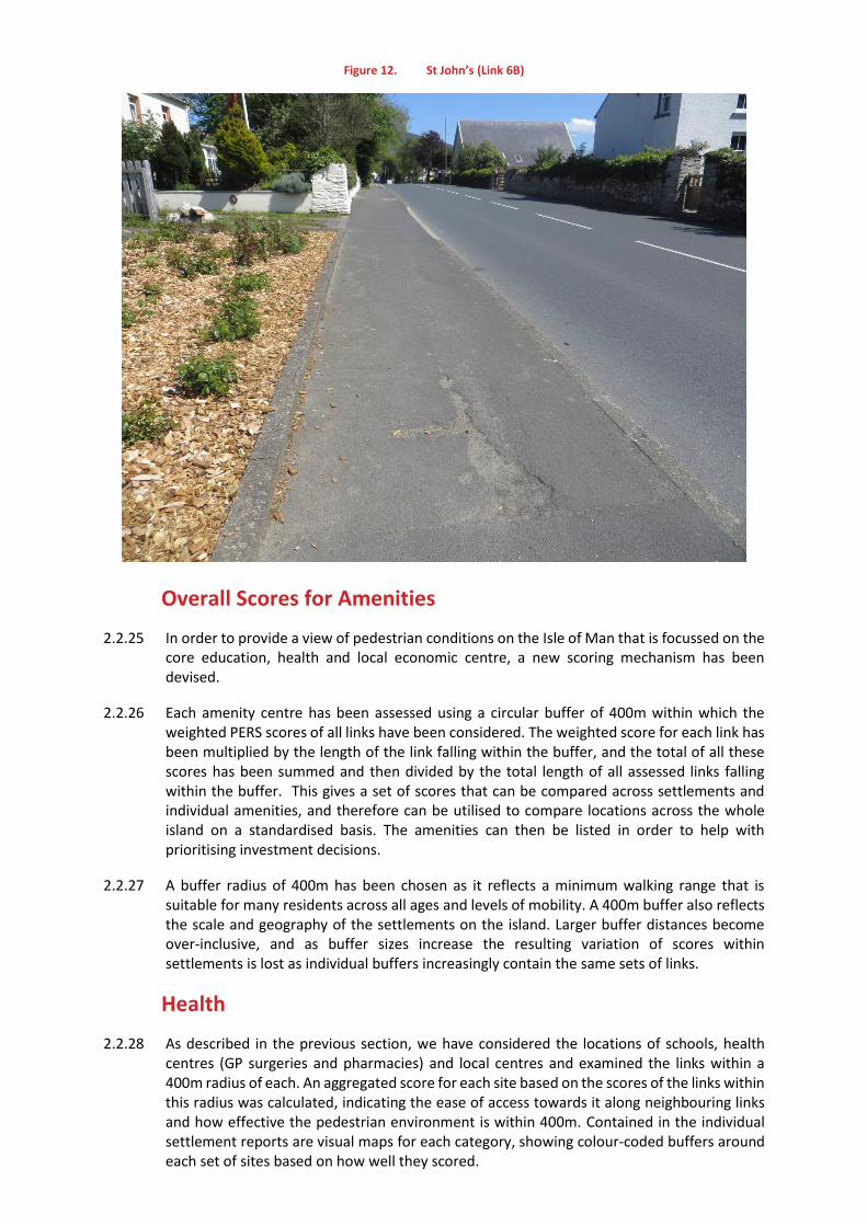
Figure 12. St John’s (Link 6B)
Overall Scores for Amenities
2.2.25 In order to provide a view of pedestrian conditions on the Isle of Man that is focussed on the core education, health and local economic centre, a new scoring mechanism has been devised.
2.2.26 Each amenity centre has been assessed using a circular buffer of 400m within which the weighted PERS scores of all links have been considered. The weighted score for each link has been multiplied by the length of the link falling within the buffer, and the total of all these scores has been summed and then divided by the total length of all assessed links falling within the buffer. This gives a set of scores that can be compared across settlements and individual amenities, and therefore can be utilised to compare locations across the whole island on a standardised basis. The amenities can then be listed in order to help with prioritising investment decisions.
2.2.27 A buffer radius of 400m has been chosen as it reflects a minimum walking range that is suitable for many residents across all ages and levels of mobility. A 400m buffer also reflects the scale and geography of the settlements on the island. Larger buffer distances become over-inclusive, and as buffer sizes increase the resulting variation of scores within settlements is lost as individual buffers increasingly contain the same sets of links.
Health
2.2.28 As described in the previous section, we have considered the locations of schools, health centres (GP surgeries and pharmacies) and local centres and examined the links within a 400m radius of each. An aggregated score for each site based on the scores of the links within this radius was calculated, indicating the ease of access towards it along neighbouring links and how effective the pedestrian environment is within 400m. Contained in the individual settlement reports are visual maps for each category, showing colour-coded buffers around each set of sites based on how well they scored.
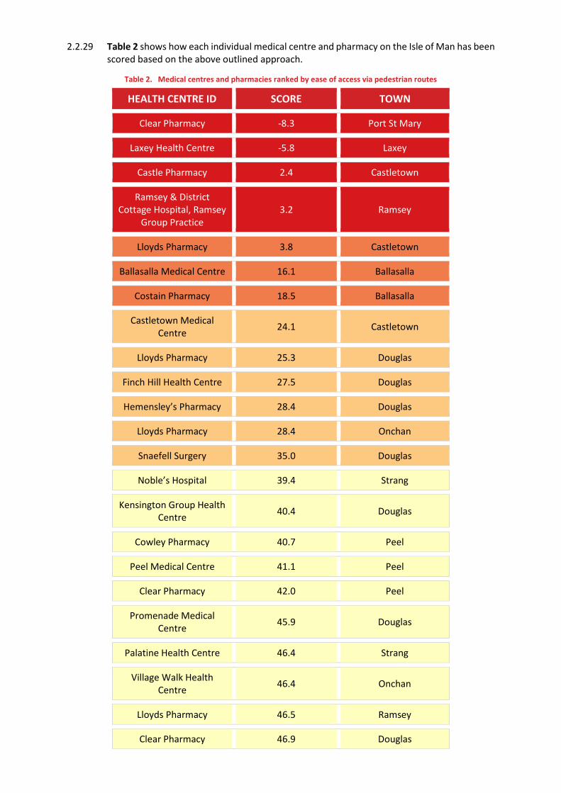
2.2.29 Table 2 shows how each individual medical centre and pharmacy on the Isle of Man has been scored based on the above outlined approach.
Table 2. Medical centres and pharmacies ranked by ease of access via pedestrian routes
HEALTH CENTRE ID SCORE TOWN
Clear Pharmacy -8.3 Port St Mary
Laxey Health Centre -5.8 Laxey
Castle Pharmacy 2.4 Castletown
Ramsey & District Cottage Hospital, Ramsey
Group Practice 3.2 Ramsey
Lloyds Pharmacy 3.8 Castletown
Ballasalla Medical Centre 16.1 Ballasalla
Costain Pharmacy 18.5 Ballasalla
Castletown Medical Centre
24.1 Castletown
Lloyds Pharmacy 25.3 Douglas
Finch Hill Health Centre 27.5 Douglas
Hemensley’s Pharmacy 28.4 Douglas
Lloyds Pharmacy 28.4 Onchan
Snaefell Surgery 35.0 Douglas
Noble’s Hospital 39.4 Strang
Kensington Group Health Centre
40.4 Douglas
Cowley Pharmacy 40.7 Peel
Peel Medical Centre 41.1 Peel
Clear Pharmacy 42.0 Peel
Promenade Medical Centre
45.9 Douglas
Palatine Health Centre 46.4 Strang
Village Walk Health Centre
46.4 Onchan
Lloyds Pharmacy 46.5 Ramsey
Clear Pharmacy 46.9 Douglas
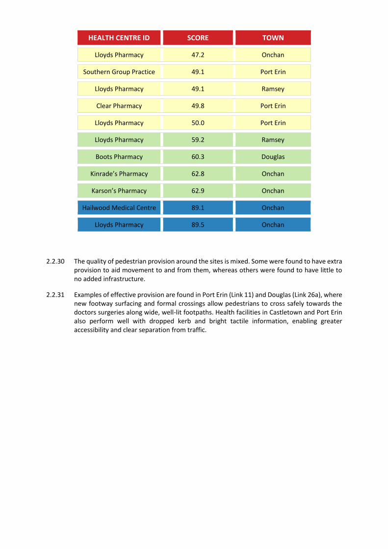
HEALTH CENTRE ID SCORE TOWN
Lloyds Pharmacy 47.2 Onchan
Southern Group Practice 49.1 Port Erin
Lloyds Pharmacy 49.1 Ramsey
Clear Pharmacy 49.8 Port Erin
Lloyds Pharmacy 50.0 Port Erin
Lloyds Pharmacy 59.2 Ramsey
Boots Pharmacy 60.3 Douglas
Kinrade’s Pharmacy 62.8 Onchan
Karson’s Pharmacy 62.9 Onchan
Hailwood Medical Centre 89.1 Onchan
Lloyds Pharmacy 89.5 Onchan
2.2.30 The quality of pedestrian provision around the sites is mixed. Some were found to have extra provision to aid movement to and from them, whereas others were found to have little to no added infrastructure.
2.2.31 Examples of effective provision are found in Port Erin (Link 11) and Douglas (Link 26a), where new footway surfacing and formal crossings allow pedestrians to cross safely towards the doctors surgeries along wide, well-lit footpaths. Health facilities in Castletown and Port Erin also perform well with dropped kerb and bright tactile information, enabling greater accessibility and clear separation from traffic.
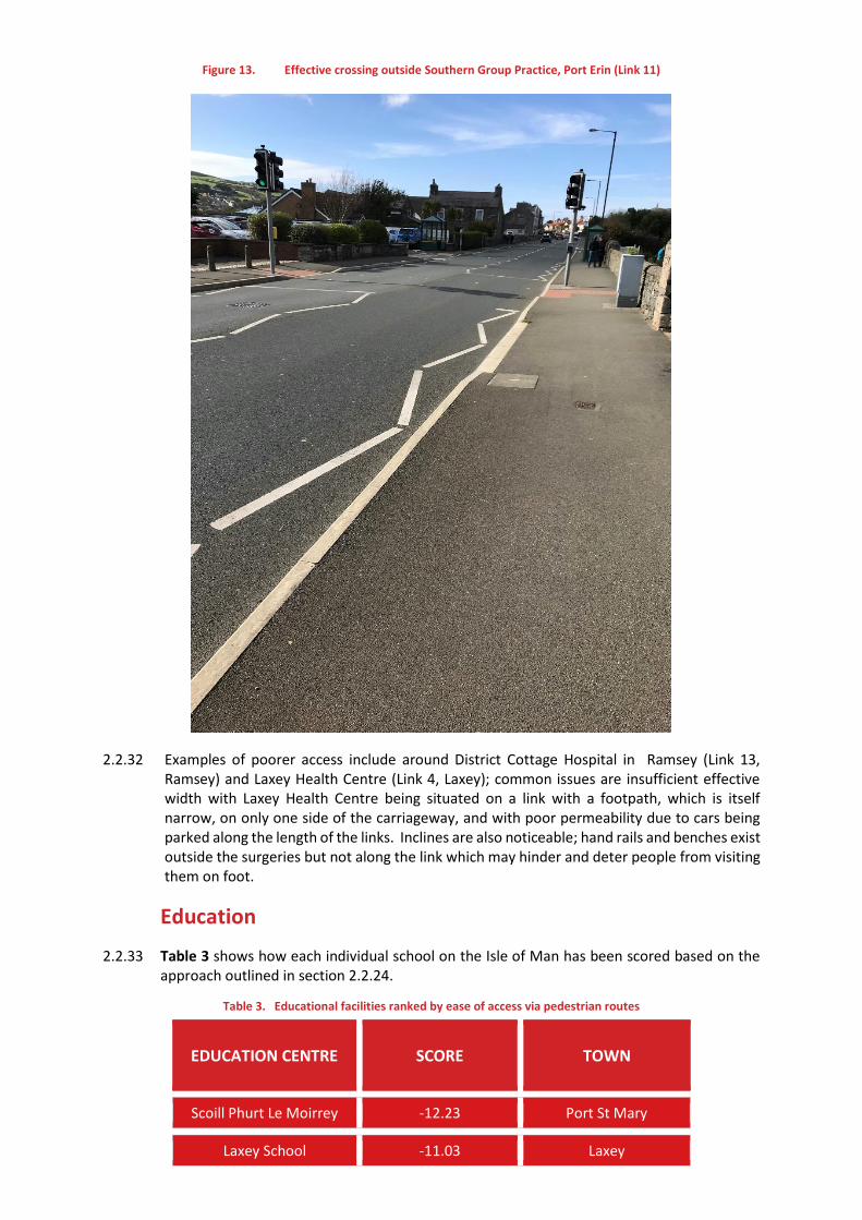
Figure 13. Effective crossing outside Southern Group Practice, Port Erin (Link 11)
2.2.32 Examples of poorer access include around District Cottage Hospital in Ramsey (Link 13, Ramsey) and Laxey Health Centre (Link 4, Laxey); common issues are insufficient effective width with Laxey Health Centre being situated on a link with a footpath, which is itself narrow, on only one side of the carriageway, and with poor permeability due to cars being parked along the length of the links. Inclines are also noticeable; hand rails and benches exist outside the surgeries but not along the link which may hinder and deter people from visiting them on foot.
Education
2.2.33 Table 3 shows how each individual school on the Isle of Man has been scored based on the approach outlined in section 2.2.24.
Table 3. Educational facilities ranked by ease of access via pedestrian routes
EDUCATION CENTRE SCORE TOWN
Scoill Phurt Le Moirrey -12.23 Port St Mary
Laxey School -11.03 Laxey
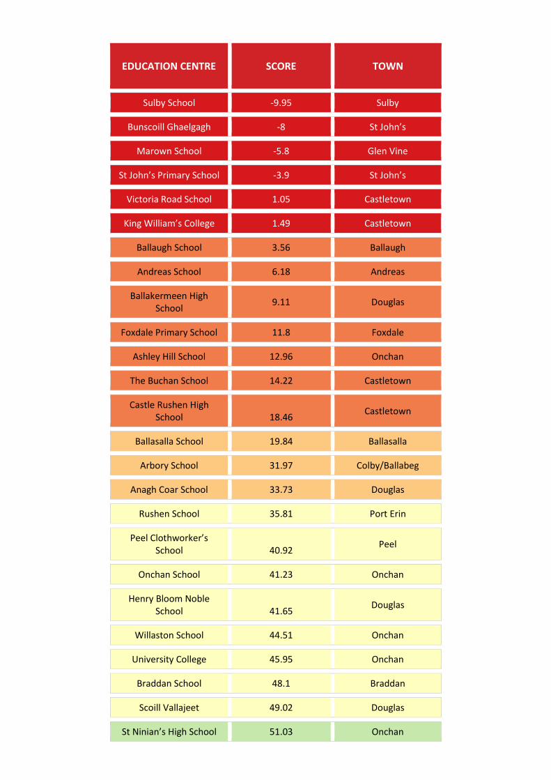
EDUCATION CENTRE SCORE TOWN
Sulby School -9.95 Sulby
Bunscoill Ghaelgagh -8 St John’s
Marown School -5.8 Glen Vine
St John’s Primary School -3.9 St John’s
Victoria Road School 1.05 Castletown
King William’s College 1.49 Castletown
Ballaugh School 3.56 Ballaugh
Andreas School 6.18 Andreas
Ballakermeen High School
9.11 Douglas
Foxdale Primary School 11.8 Foxdale
Ashley Hill School 12.96 Onchan
The Buchan School 14.22 Castletown
Castle Rushen High School 18.46
Castletown
Ballasalla School 19.84 Ballasalla
Arbory School 31.97 Colby/Ballabeg
Anagh Coar School 33.73 Douglas
Rushen School 35.81 Port Erin
Peel Clothworker’s School 40.92
Peel
Onchan School 41.23 Onchan
Henry Bloom Noble School 41.65
Douglas
Willaston School 44.51 Onchan
University College 45.95 Onchan
Braddan School 48.1 Braddan
Scoill Vallajeet 49.02 Douglas
St Ninian’s High School 51.03 Onchan
EDUCATION CENTRE SCORE TOWN
Saint Ninian’s Lower School 52.69
Onchan
St Mary’s Roman Catholic School 60.01
Onchan
Auldyn School 60.68 Ramsey
Ballacottier School 63.17 Douglas
Ramsey Grammar School 67.25 Ramsey
Queen Elizabeth II School 76 Peel
Cronk-Y-Berry School 86.82 Onchan
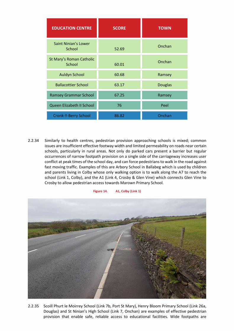
2.2.34 Similarly to health centres, pedestrian provision approaching schools is mixed; common issues are insufficient effective footway width and limited permeability on roads near certain schools, particularly in rural areas. Not only do parked cars present a barrier but regular occurrences of narrow footpath provision on a single side of the carriageway increases user conflict at peak times of the school day, and can force pedestrians to walk in the road against fast moving traffic. Examples of this are Arbory School in Ballabeg which is used by children and parents living in Colby whose only walking option is to walk along the A7 to reach the school (Link 1, Colby), and the A1 (Link 4, Crosby & Glen Vine) which connects Glen Vine to Crosby to allow pedestrian access towards Marown Primary School.
Figure 14. A1, Colby (Link 1)
2.2.35 Scoill Phurt le Moirrey School (Link 7b, Port St Mary), Henry Bloom Primary School (Link 26a, Douglas) and St Ninian’s High School (Link 7, Onchan) are examples of effective pedestrian provision that enable safe, reliable access to educational facilities. Wide footpaths are
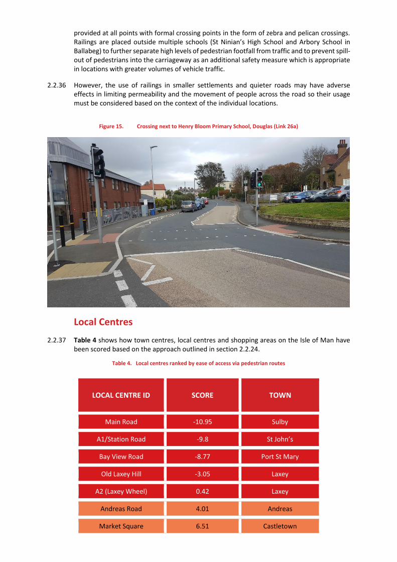
provided at all points with formal crossing points in the form of zebra and pelican crossings. Railings are placed outside multiple schools (St Ninian’s High School and Arbory School in Ballabeg) to further separate high levels of pedestrian footfall from traffic and to prevent spill-out of pedestrians into the carriageway as an additional safety measure which is appropriate in locations with greater volumes of vehicle traffic.
2.2.36 However, the use of railings in smaller settlements and quieter roads may have adverse effects in limiting permeability and the movement of people across the road so their usage must be considered based on the context of the individual locations.
Figure 15. Crossing next to Henry Bloom Primary School, Douglas (Link 26a)
Local Centres
2.2.37 Table 4 shows how town centres, local centres and shopping areas on the Isle of Man have been scored based on the approach outlined in section 2.2.24.
Table 4. Local centres ranked by ease of access via pedestrian routes
LOCAL CENTRE ID SCORE TOWN
Main Road -10.95 Sulby
A1/Station Road -9.8 St John’s
Bay View Road -8.77 Port St Mary
Old Laxey Hill -3.05 Laxey
A2 (Laxey Wheel) 0.42 Laxey
Andreas Road 4.01 Andreas
Market Square 6.51 Castletown
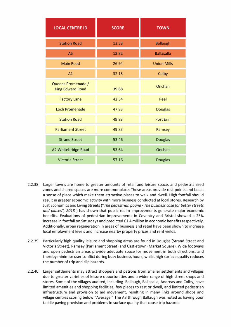
LOCAL CENTRE ID SCORE TOWN
Station Road 13.53 Ballaugh
A5 13.82 Ballasalla
Main Road 26.94 Union Mills
A1 32.15 Colby
Queens Promenade / King Edward Road 39.88
Onchan
Factory Lane 42.54 Peel
Loch Promenade 47.83 Douglas
Station Road 49.83 Port Erin
Parliament Street 49.83 Ramsey
Strand Street 53.46 Douglas
A2 Whitebridge Road 53.64 Onchan
Victoria Street 57.16 Douglas
2.2.38 Larger towns are home to greater amounts of retail and leisure space, and pedestrianised zones and shared spaces are more commonplace. These areas provide rest points and boast a sense of place which make them attractive places to walk and dwell. High footfall should result in greater economic activity with more business conducted at local stores. Research by Just Economics and Living Streets (“The pedestrian pound - The business case for better streets and places”, 2018 ) has shown that public realm improvements generate major economic benefits. Evaluations of pedestrian improvements in Coventry and Bristol showed a 25% increase in footfall on Saturdays and predicted £1.4 million in economic benefits respectively. Additionally, urban regeneration in areas of business and retail have been shown to increase local employment levels and increase nearby property prices and rent yields.
2.2.39 Particularly high quality leisure and shopping areas are found in Douglas (Strand Street and Victoria Street), Ramsey (Parliament Street) and Castletown (Market Square). Wide footways and open pedestrian areas provide adequate space for movement in both directions, and thereby minimise user conflict during busy business hours, whilst high surface quality reduces the number of trip and slip hazards.
2.2.40 Larger settlements may attract shoppers and patrons from smaller settlements and villages due to greater varieties of leisure opportunities and a wider range of high street shops and stores. Some of the villages audited, including Ballaugh, Ballasalla, Andreas and Colby, have limited amenities and shopping facilities, few places to rest or dwell, and limited pedestrian infrastructure and provision to aid movement, resulting in many links around shops and village centres scoring below “Average.” The A3 through Ballaugh was noted as having poor tactile paving provision and problems in surface quality that cause trip hazards.

2.2.41 Issues that consistently arise are a lack of footpaths on both sides of the carriageway along major corridors such as the A9 through Andreas, the A7 through Colby, the A2 through Baldrine and the A1 in St John’s; where pavement does exist, it is again often narrow, leading to problems in user conflict, poor pedestrian comfort and poor permeability.
Comparing the PERS on the Isle of Man with other PERS studies
2.2.42 UK-based PERS studies have thus far been conducted predominantly in boroughs and districts in major cities such as London and Brighton, and not in rural areas. Three such London studies that have been completed by SYSTRA were in Colindale, Poplar and Ealing; the average weighted link scores yielded were 63.3, 70.1 and 77.8 respectively, all of which are significantly greater than the highest average weighted link score in the Isle of Man.
2.2.43 One potential factor for the difference in average score could be due to the purely urban nature of links located in inner-city London and the lack of rural links. This is favourable as in the Isle of Man, it has been seen that primarily rural settlements tend to have less effective footpath provision as footpaths are either provided on a single side of a carriageway or not provided at all.
2.2.44 PERS studies in London districts are found to suffer from many of the same problems found in numerous Isle of Man settlements such as incomplete or inconsistent dropped kerb provision, reduced permeability due to a lack of formal crossing points, and surface quality issues. Guidance from previous SYSTRA PERS studies advises the re-provision of carriageway, footways and lighting in line with the latest design guidance to mitigate these issues, particularly if increases in pedestrian movement are anticipated due to proposed and ongoing developments.
2.2.45 Again prevalent, particularly in Colindale in the vicinity of local primary schools and parks, is a clear deficiency in pedestrian signage. The recommended measure to mitigate this problem was therefore to provide new pedestrian signage throughout key pedestrian links to improve both wayfinding and connectivity.
2.2.46 However, the London boroughs and districts of Ealing and Poplar consistently outperform the Isle of Man in key parameters such as effective width and minimisation of user conflict to lessen the difficulties faced by large amounts of anticipated residential foot traffic. With the provision of footpaths on both sides of carriageways, the vast majority of links studied in the district of Ealing were scored between “Good” and “Very Good” with only three links noted as “Average” or below.
2.2.47 As mentioned, PERS studies have also been conducted in Brighton (“East Brighton Walking and Cycling Permeability Study”, 2016); high scores were given in locations recently subjected to refurbishment and renovation that resulted in “headway treatments on side-entry junctions, improved permeability for pedestrians along the footways, high quality paving materials, and improved legibility for pedestrians.” Clear signage and legibility is a parameter that many links in the Isle of Man score poorly in, and so results in Brighton show that work in this area would greatly benefit the pedestrian environment.
2.2.48 The lowest achieving links in Brighton suffer from the same problems as those in the Isle of Man as existing footways were either very narrow or not present on both sides of the carriageway.
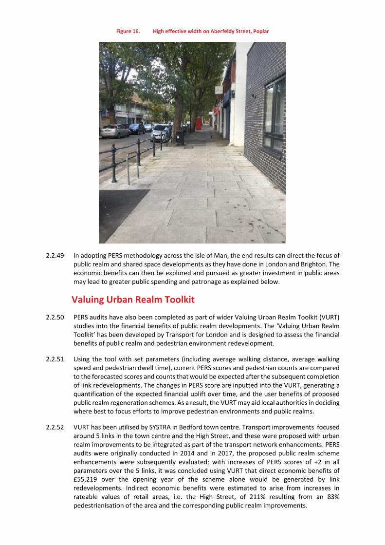
Figure 16. High effective width on Aberfeldy Street, Poplar
2.2.49 In adopting PERS methodology across the Isle of Man, the end results can direct the focus of public realm and shared space developments as they have done in London and Brighton. The economic benefits can then be explored and pursued as greater investment in public areas may lead to greater public spending and patronage as explained below.
Valuing Urban Realm Toolkit
2.2.50 PERS audits have also been completed as part of wider Valuing Urban Realm Toolkit (VURT) studies into the financial benefits of public realm developments. The ‘Valuing Urban Realm Toolkit’ has been developed by Transport for London and is designed to assess the financial benefits of public realm and pedestrian environment redevelopment.
2.2.51 Using the tool with set parameters (including average walking distance, average walking speed and pedestrian dwell time), current PERS scores and pedestrian counts are compared to the forecasted scores and counts that would be expected after the subsequent completion of link redevelopments. The changes in PERS score are inputted into the VURT, generating a quantification of the expected financial uplift over time, and the user benefits of proposed public realm regeneration schemes. As a result, the VURT may aid local authorities in deciding where best to focus efforts to improve pedestrian environments and public realms.
2.2.52 VURT has been utilised by SYSTRA in Bedford town centre. Transport improvements focused around 5 links in the town centre and the High Street, and these were proposed with urban realm improvements to be integrated as part of the transport network enhancements. PERS audits were originally conducted in 2014 and in 2017, the proposed public realm scheme enhancements were subsequently evaluated; with increases of PERS scores of +2 in all parameters over the 5 links, it was concluded using VURT that direct economic benefits of £55,219 over the opening year of the scheme alone would be generated by link redevelopments. Indirect economic benefits were estimated to arise from increases in rateable values of retail areas, i.e. the High Street, of 211% resulting from an 83% pedestrianisation of the area and the corresponding public realm improvements.
2.2.53 Similarly in Auckland, New Zealand, a VURT study found that the development of a shared space for pedestrians (who have the absolute priority throughout the space), cyclists and loading/unloading traffic in a major city centre street (Fort Street) led to a 47% increase in consumer spending and a 429% increase in hospitality spending1.
2.3 Conclusion and Recommendations
2.3.1 The best performing towns on the Isle of Man are the larger towns, with six of the top eight highest-scoring settlements having more than 40 links and the remaining two having 12 or fewer. In these cases, high scores have been awarded in part because as larger towns they offer more space for leisure, tourism and retail, leading to greater focus on providing high quality public environments and spaces with suitable pedestrian provision, maintenance and upkeep.
2.3.2 Throughout the Isle of Man, smaller rural settlements are more focused on local residential living but suffer from a lack of lighting and consistent, wide pavement provision as footways are provided on only one side of the carriageway at the most. Much of this provision is less than 1.8m wide; on the edges of settlements and moving away from settlement centres, carriageways are often bounded on one side by tall grass verges or hedges which may cause some difficulties in installing new footpaths as it would lead to a large reduction in the width of the actual road and carriageway. Instead, it may be more feasible to slightly increase the width of existing footpaths as this would encroach less onto the road. With winding roads and limited sightlines, settlements such as Colby, Ballaugh, Baldrine, Laxey and Sulby that have links with no footpaths may present a danger as people are forced to walk in the road with no separation from traffic.
2.3.3 Dropped kerbs, tactile information and pedestrian street signage provision are inconsistent throughout the island in both urban and rural environments. Wayfinding through residential areas is therefore made difficult for those not local to the area.
2.3.4 Links surrounding schools and health facilities vary depending on location, but issues with permeability were noted and user conflict anticipated where footpath provision is limited, again in Colby, Laxey and Ramsey.
2.3.5 The work presented by SYSTRA aligns itself well with the Sustrans Active Travel Strategy. By identifying improvements to the current pedestrian infrastructure across both rural and urban environments, key routes can be further utilised and developed for active travel across the Isle of Man; the vision of a 14% increase in the number of people walking and cycling across the island from the 2011 figure may therefore be realised in line with the aforementioned strategy. Around Ballakermeen High School, initial trials as outlined by Sustrans2 will aim to tackle -
Signage
Junctions and congestion
and these themes are very similar to the problems identified as needing investment and a focus in this PERS study. The links in close proximity of the school are Links 6a, 6b, 9 and 10 in Douglas; other issues affecting them were found to be the lack of dropped kerbs and tactile information, the limits on pedestrian permeability due to parked cars and school traffic, and narrowing footpath issues that may cause heavy foot traffic to spill into the road. As a result, Links 6a and 10 were scored as “Average”, 6b was scored as very poor and Link 9 was scored as poor.
2.3.6 Our suggested recommendations for the Isle of Man, pending further investigation, are:
1 http://knowledgeauckland.org.nz/assets/publications/Value-of-the-urban-realm-toolkit-for-Auckland-Boffa-Miskell-2017-part-1.pdf 2 https://www.sustrans.org.uk/news/isle-man-launches-38m-active-travelprogramme

Exploring Local Cycling and Walking Infrastructure Plans (LCWIPs); LCWIPs have so far been undertaken by SYSTRA to assess the effectiveness of pedestrian routes in Gloucestershire and Cheltenham. Devised by the Department for Transport (DfT), an LCWIP in a pedestrian environment consists of a walking route audit through core walking zones and is designed to - o Produce a ‘Walking Network Map’ of proposed future, and preferred current,
walking networks/routes from origin to destination.
o Identify a ‘Programme of Walking Infrastructure Improvements’ – a cost-estimated summary of locations where interventions and improvements are required in order for the audited walking routes to be deemed of satisfactory quality and usability.
Address the common themes of dropped kerbs and tactile information provision in all
settlements as this acts as a barrier to movement and permeability, prioritising those close to key destinations such as schools, hospitals and local centres.
Apply the Valuing Urban Realm Toolkit to estimate the monetary values and benefits from
public realm redevelopment and investment in key areas. Notable examples of already successful redevelopment include Castletown Square, Laxey Bridge and shopping areas in central Douglas and Ramsey. Ease of access to frontages is beneficial to local businesses and economies in shopping, leisure and recreational areas often found in town centres and promenades. The results of using VURT can direct where redevelopment schemes should be implemented to provide the greatest benefits i.e. by attracting the greatest number of people to local hotspots and promoting consumer and hospitality spending.
Following on from the examples of Douglas, Ramsey and Castletown, similar investments can be recommended for Peel. Though there is a central promenade and the remains of Peel Castle, pedestrianised shopping areas are lacking in the centre of the town and narrow footway provision along Douglas Street may be dangerous for pedestrian use against traffic. Similar arguments can be made for smaller settlements such as Andreas, Sulby, Colby and Ballaugh as a lack of central pedestrianised leisure areas may limit the growth of local economies.
Prioritise the provision of crossings and wide footpaths on both sides of the road in rural villages and approaching both urban and rural schools, thus separating pedestrians and traffic and allowing safe access for children and parents. The towns and schools where this would be most beneficial are;
o Colby/Ballabeg – Arbory School o St John’s – St John’s Primary School o Foxdale – Foxdale Primary School o Douglas - Richard Milos Kewaigue Primary School o Glen Vine – Marown Primary School o Peel – Queen Elizabeth II High School o Laxey – Laxey School o Ballaugh – Ballaugh School o Sulby – Sulby School o Ramsey – Ramsey Grammar School and Bunscoill Rhumsaa
Increase signage in the form of street road names and pedestrian signage to aid
wayfinding and navigation to key destinations such as schools, hospitals and local centres.
Address the difficulty in traversing steep gradients; though it may not be possible to make topographical changes, the ease with which pedestrians move along gradients may be increased with more rest points and hand railing provision where necessary. This issue is

apparent in such settlements as Laxey where steep hills, again with little footpath provision, make it difficult and potentially dangerous to move from place to place.
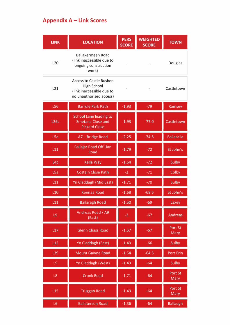
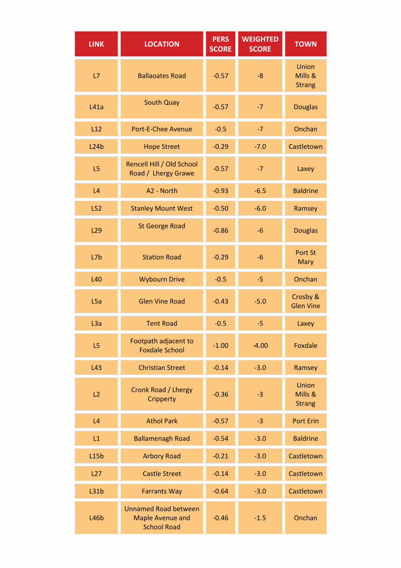
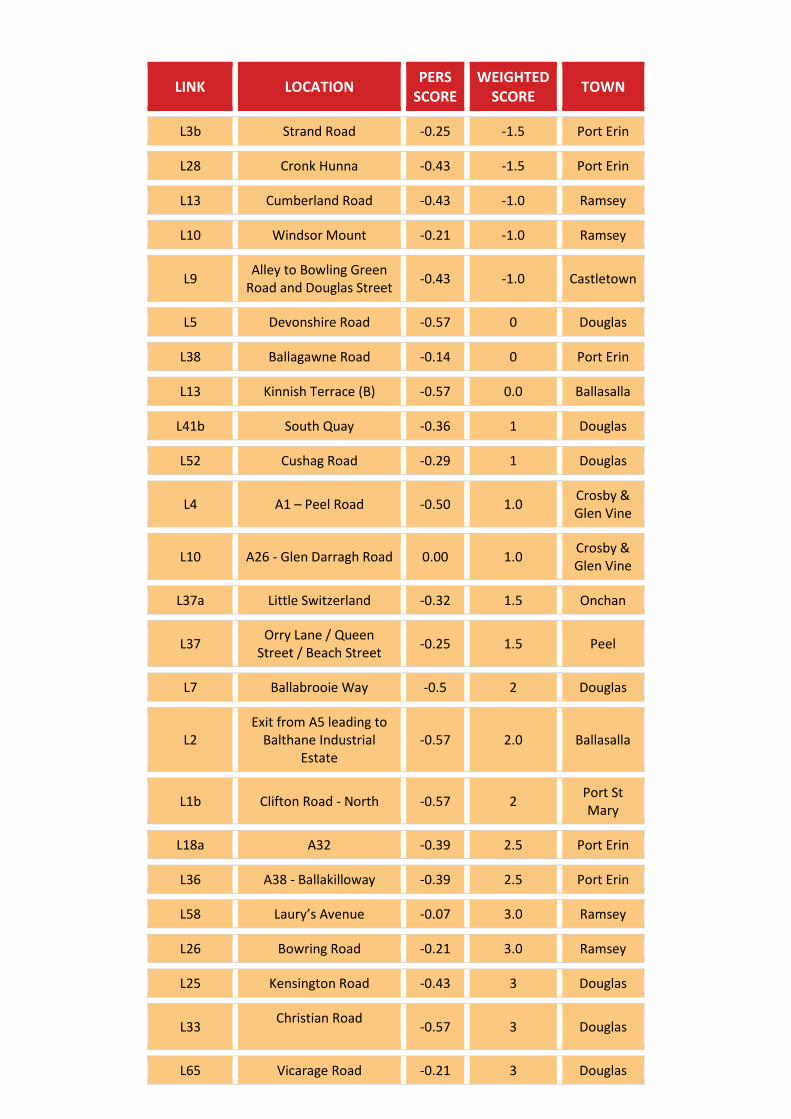
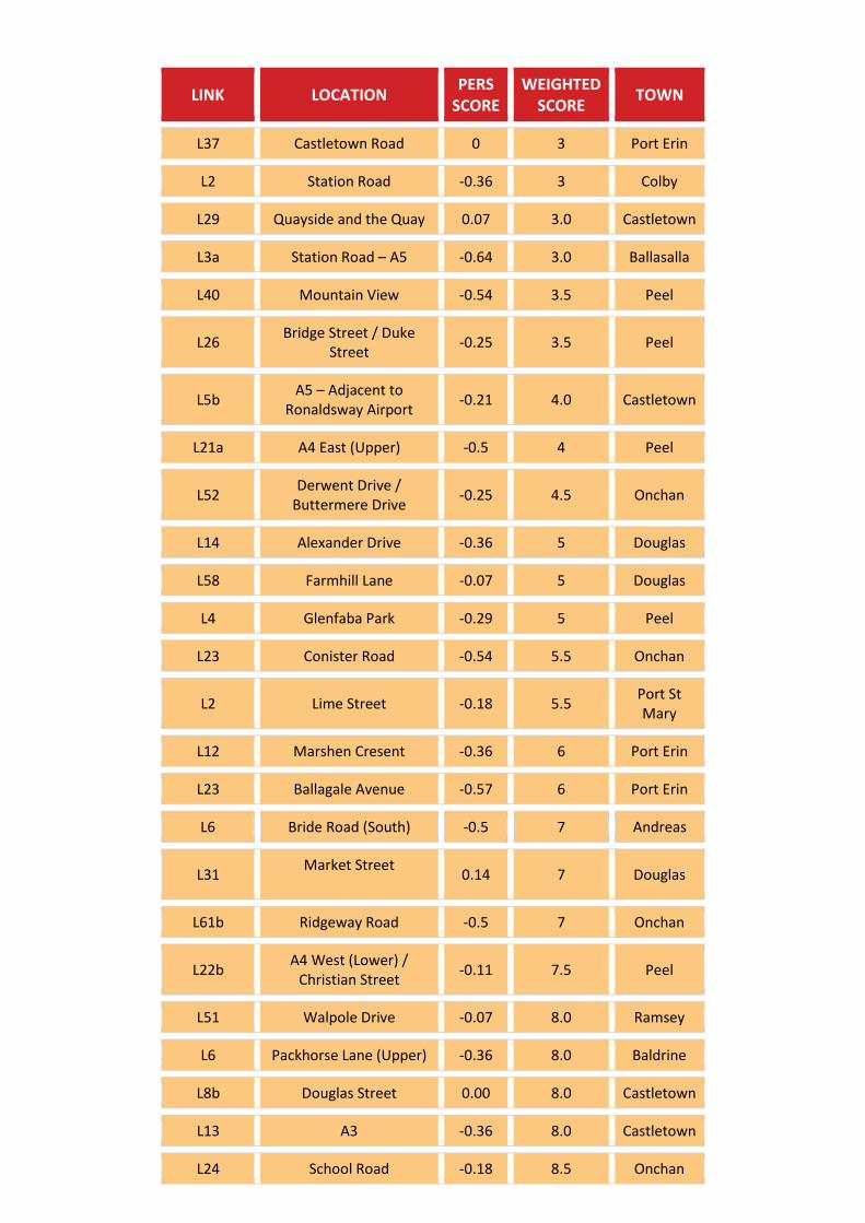
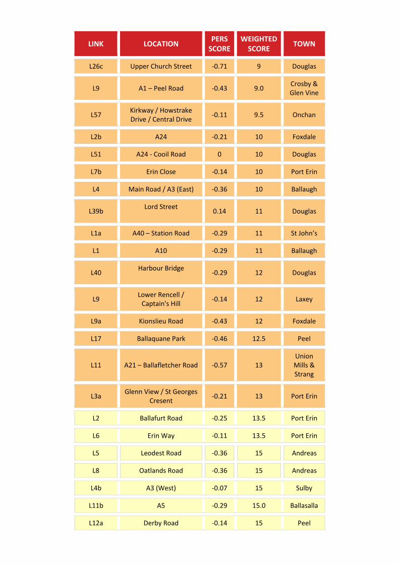
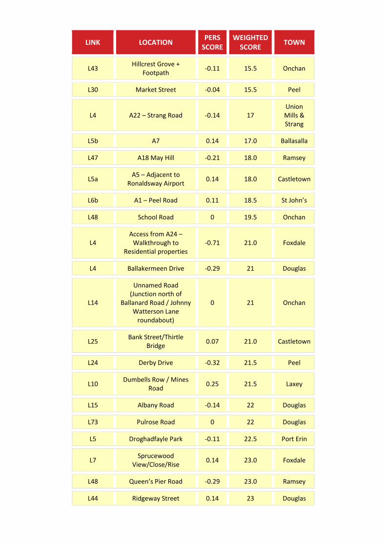
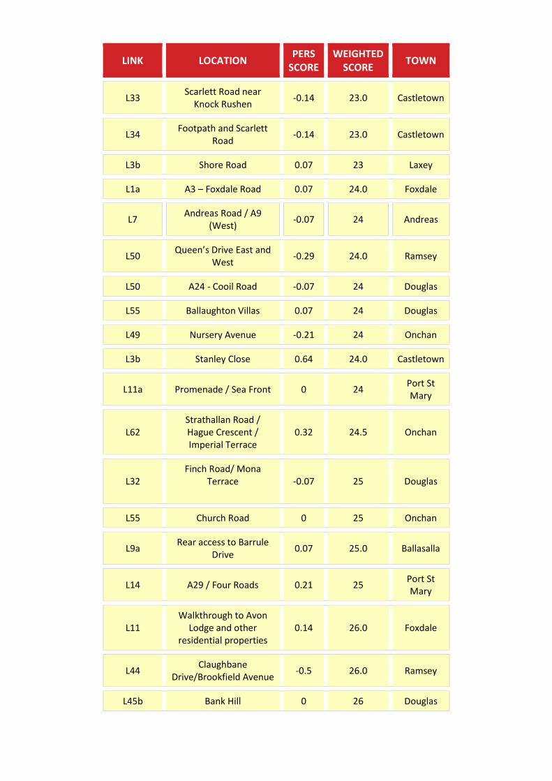
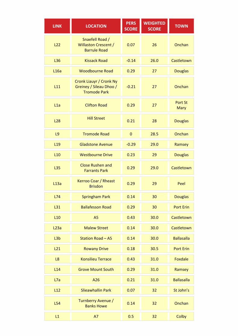
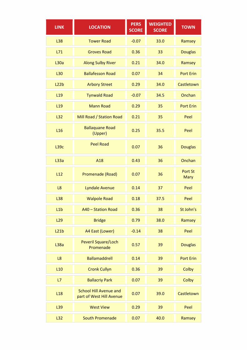
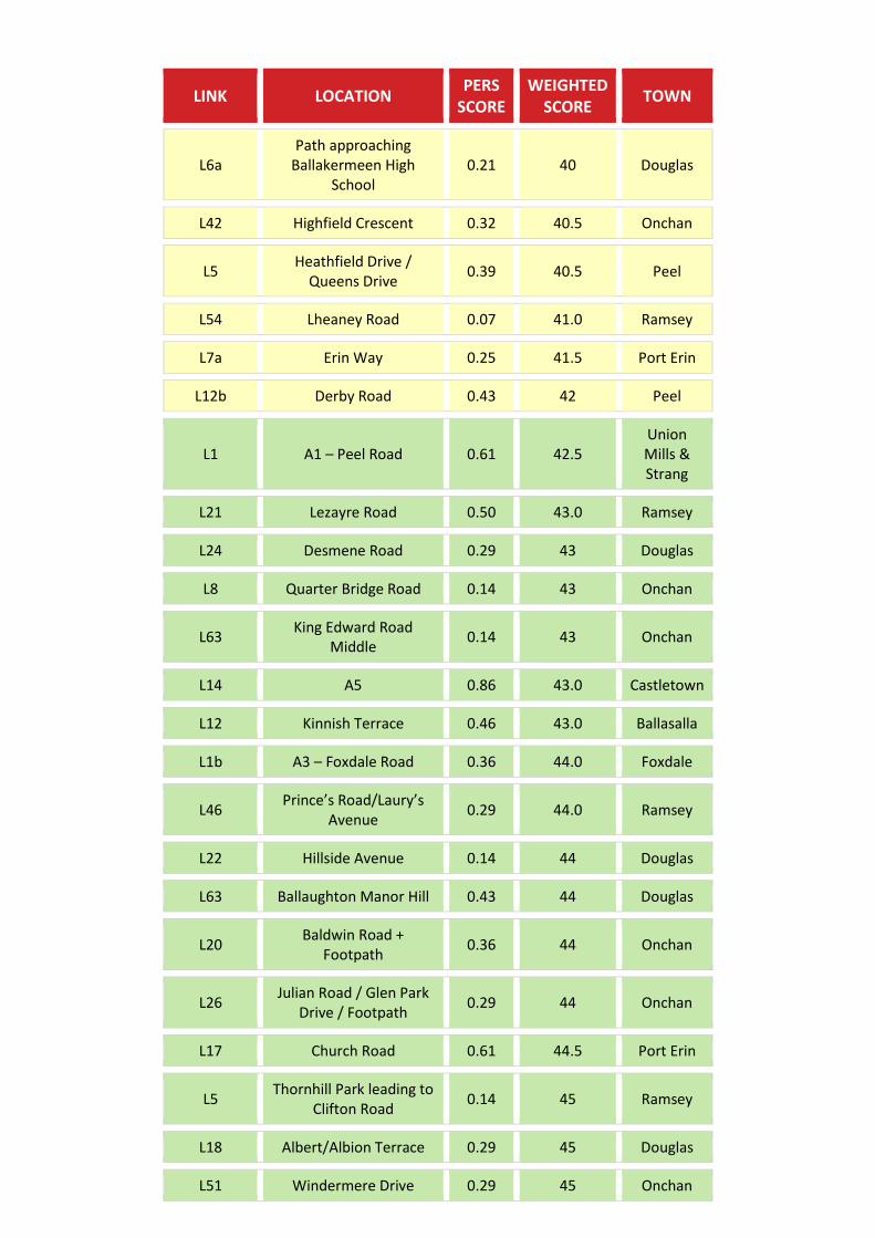
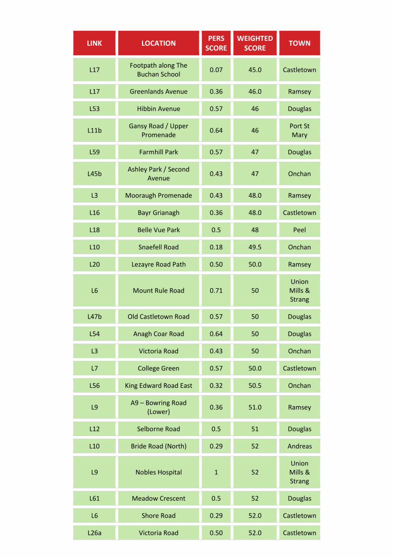
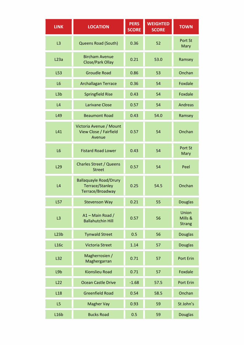
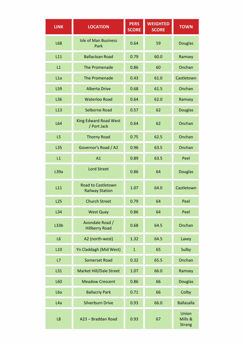
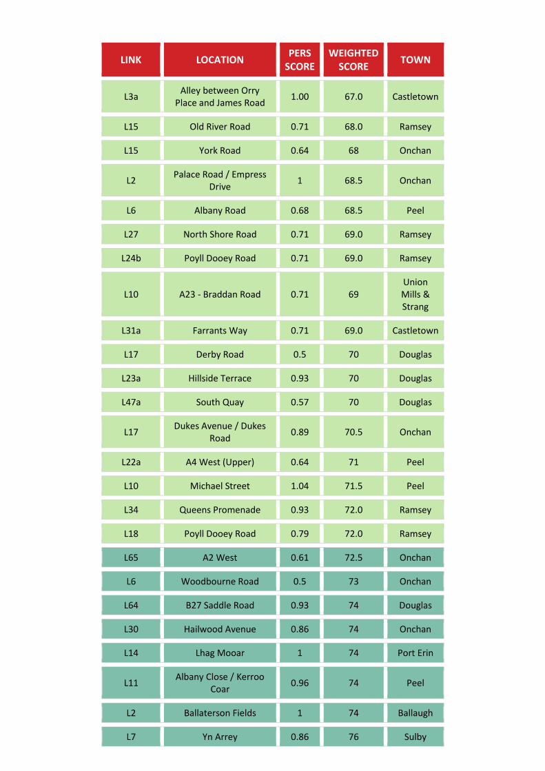
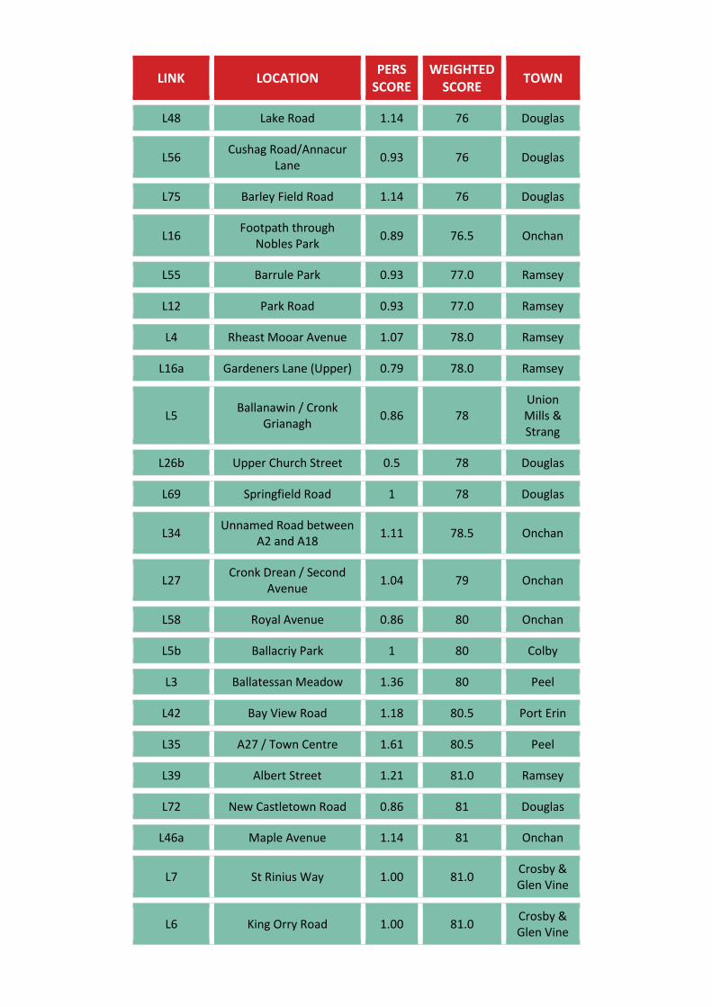
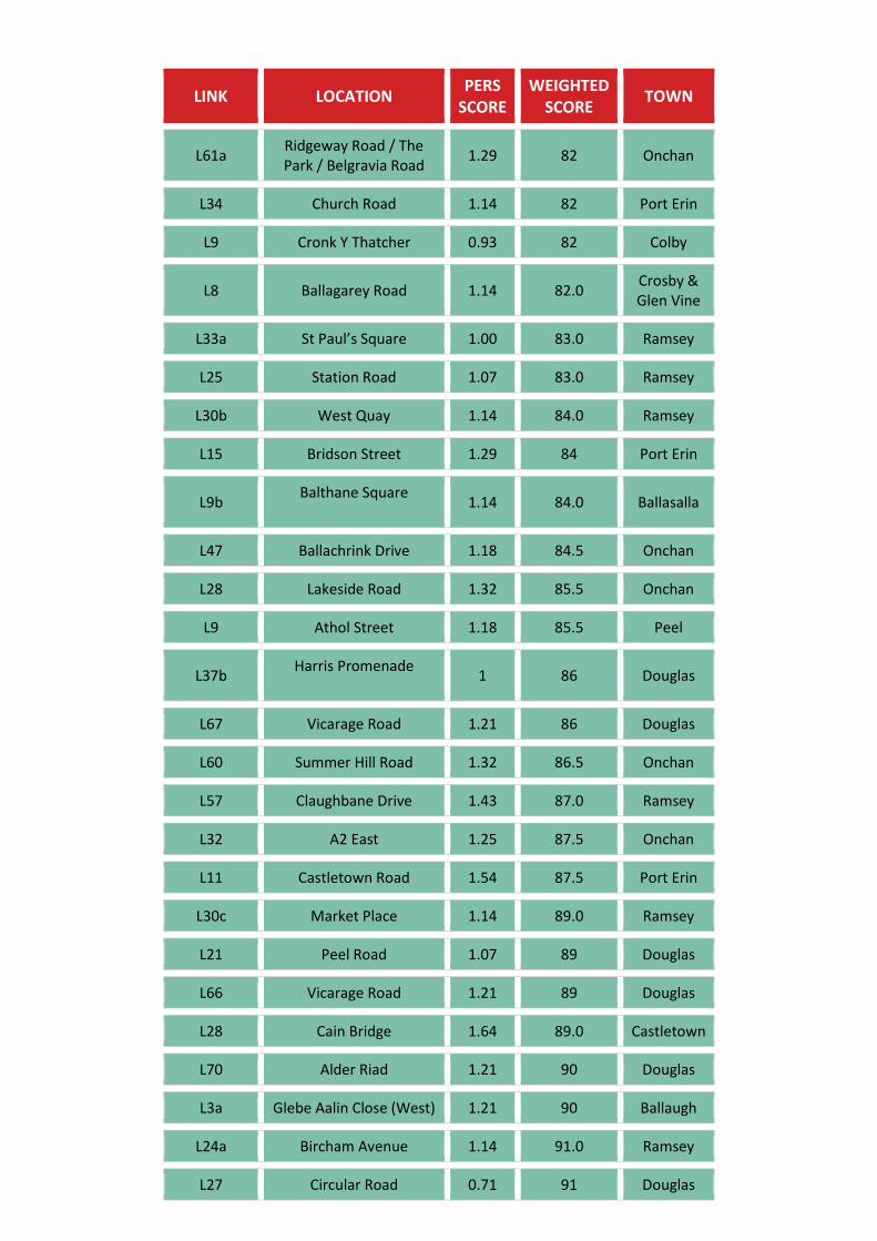
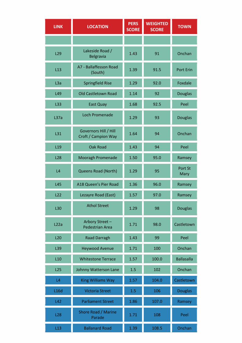
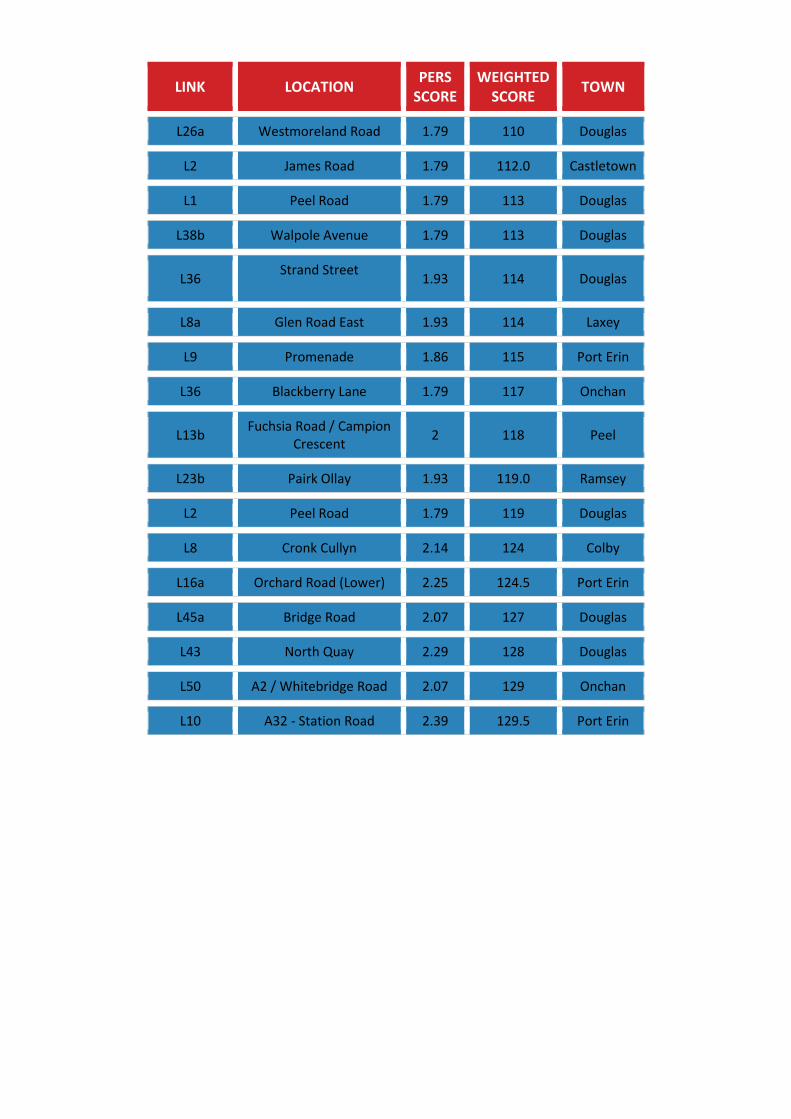
Appendix A – Link Scores
LINK LOCATION PERS
SCORE WEIGHTED
SCORE TOWN
L20
Ballakermeen Road (link inaccessible due to
ongoing construction work)
- - Douglas
L21
Access to Castle Rushen High School
(link inaccessible due to no unauthorised access)
- - Castletown
L56 Barrule Park Path -1.93 -79 Ramsey
L26c School Lane leading to
Smetana Close and Pickard Close
-1.93 -77.0 Castletown
L5a A7 – Bridge Road -2.25 -74.5 Ballasalla
L11 Ballajar Road Off Lian
Road -1.79 -72 St John’s
L4c Kella Way -1.64 -72 Sulby
L5a Costain Close Path -2 -71 Colby
L11 Yn Claddagh (Mid East) -1.71 -70 Sulby
L10 Kennaa Road -1.68 -68.5 St John’s
L11 Ballaragh Road -1.50 -69 Laxey
L9 Andreas Road / A9
(East) -2 -67 Andreas
L17 Glenn Chass Road -1.57 -67 Port St Mary
L12 Yn Claddagh (East) -1.43 -66 Sulby
L39 Mount Gawne Road -1.54 -64.5 Port Erin
L9 Yn Claddagh (West) -1.43 -64 Sulby
L8 Cronk Road -1.71 -64 Port St Mary
L15 Truggan Road -1.43 -64 Port St Mary
L6 Ballaterson Road -1.36 -64 Ballaugh
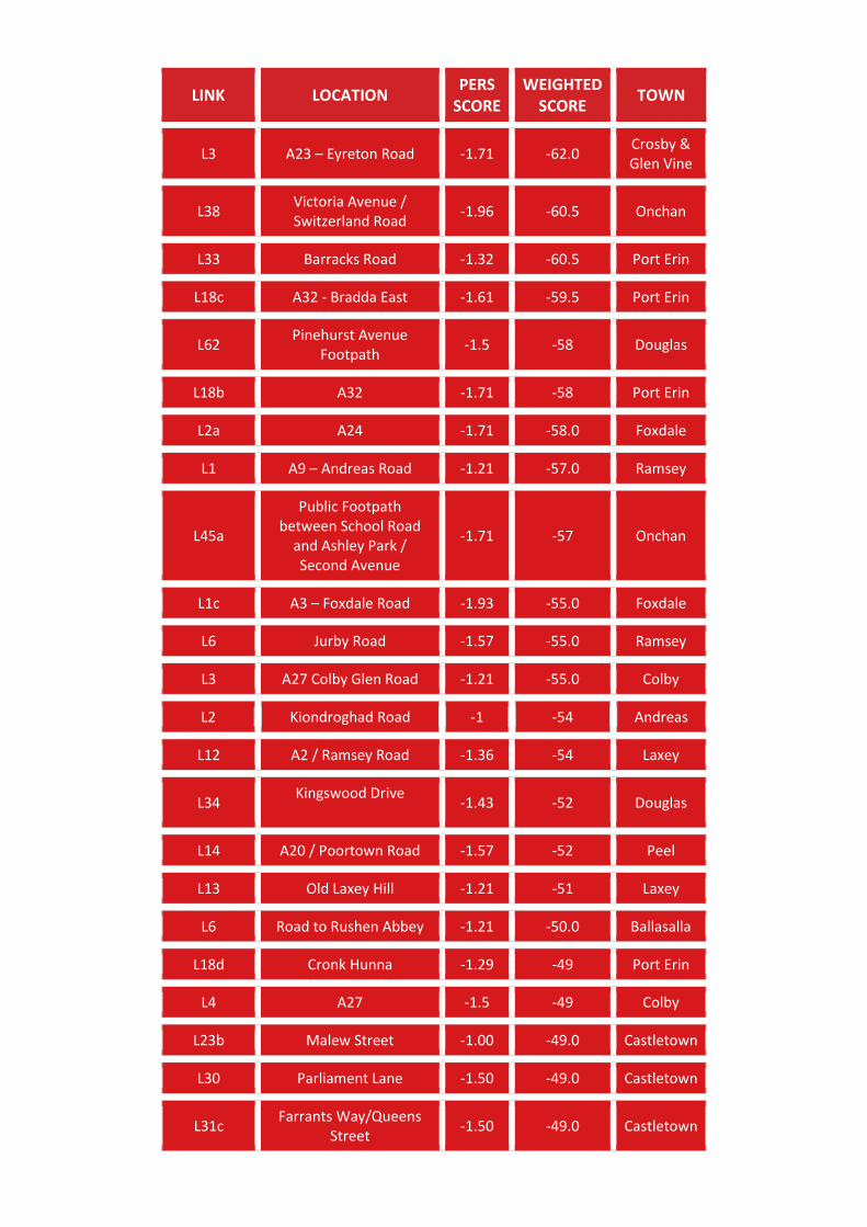
LINK LOCATION PERS
SCORE WEIGHTED
SCORE TOWN
L3 A23 – Eyreton Road -1.71 -62.0 Crosby & Glen Vine
L38 Victoria Avenue / Switzerland Road
-1.96 -60.5 Onchan
L33 Barracks Road -1.32 -60.5 Port Erin
L18c A32 - Bradda East -1.61 -59.5 Port Erin
L62 Pinehurst Avenue
Footpath -1.5 -58 Douglas
L18b A32 -1.71 -58 Port Erin
L2a A24 -1.71 -58.0 Foxdale
L1 A9 – Andreas Road -1.21 -57.0 Ramsey
L45a
Public Footpath between School Road
and Ashley Park / Second Avenue
-1.71 -57 Onchan
L1c A3 – Foxdale Road -1.93 -55.0 Foxdale
L6 Jurby Road -1.57 -55.0 Ramsey
L3 A27 Colby Glen Road -1.21 -55.0 Colby
L2 Kiondroghad Road -1 -54 Andreas
L12 A2 / Ramsey Road -1.36 -54 Laxey
L34 Kingswood Drive
-1.43 -52 Douglas
L14 A20 / Poortown Road -1.57 -52 Peel
L13 Old Laxey Hill -1.21 -51 Laxey
L6 Road to Rushen Abbey -1.21 -50.0 Ballasalla
L18d Cronk Hunna -1.29 -49 Port Erin
L4 A27 -1.5 -49 Colby
L23b Malew Street -1.00 -49.0 Castletown
L30 Parliament Lane -1.50 -49.0 Castletown
L31c Farrants Way/Queens
Street -1.50 -49.0 Castletown
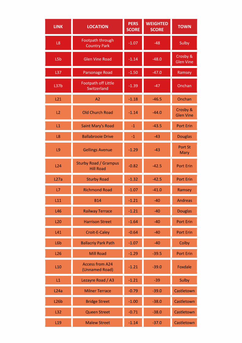
LINK LOCATION PERS
SCORE WEIGHTED
SCORE TOWN
L8 Footpath through
Country Park -1.07 -48 Sulby
L5b Glen Vine Road -1.14 -48.0 Crosby & Glen Vine
L37 Parsonage Road -1.50 -47.0 Ramsey
L37b Footpath off Little
Switzerland -1.39 -47 Onchan
L21 A2 -1.18 -46.5 Onchan
L2 Old Church Road -1.14 -44.0 Crosby & Glen Vine
L1 Saint Mary's Road -1 -43.5 Port Erin
L8 Ballabrooie Drive -1 -43 Douglas
L9 Gellings Avenue -1.29 -43 Port St Mary
L24 Sturby Road / Grampus
Hill Road -0.82 -42.5 Port Erin
L27a Sturby Road -1.32 -42.5 Port Erin
L7 Richmond Road -1.07 -41.0 Ramsey
L11 B14 -1.21 -40 Andreas
L46 Railway Terrace -1.21 -40 Douglas
L20 Harrison Street -1.64 -40 Port Erin
L41 Croit-E-Caley -0.64 -40 Port Erin
L6b Ballacriy Park Path -1.07 -40 Colby
L26 Mill Road -1.29 -39.5 Port Erin
L10 Access from A24 (Unnamed Road)
-1.21 -39.0 Foxdale
L1 Lezayre Road / A3 -1.21 -39 Sulby
L24a Milner Terrace -0.79 -39.0 Castletown
L26b Bridge Street -1.00 -38.0 Castletown
L32 Queen Street -0.71 -38.0 Castletown
L19 Malew Street -1.14 -37.0 Castletown
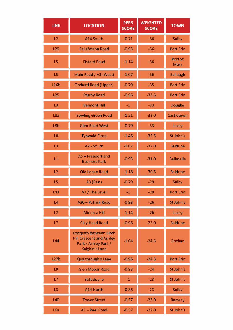
LINK LOCATION PERS
SCORE WEIGHTED
SCORE TOWN
L2 A14 South -0.71 -36 Sulby
L29 Ballafesson Road -0.93 -36 Port Erin
L5 Fistard Road -1.14 -36 Port St Mary
L5 Main Road / A3 (West) -1.07 -36 Ballaugh
L16b Orchard Road (Upper) -0.79 -35 Port Erin
L25 Sturby Road -0.96 -33.5 Port Erin
L3 Belmont Hill -1 -33 Douglas
L8a Bowling Green Road -1.21 -33.0 Castletown
L8b Glen Road West -0.79 -33 Laxey
L8 Tynwald Close -1.46 -32.5 St John’s
L3 A2 - South -1.07 -32.0 Baldrine
L1 A5 – Freeport and
Business Park -0.93 -31.0 Ballasalla
L2 Old Lonan Road -1.18 -30.5 Baldrine
L5 A3 (East) -0.79 -29 Sulby
L43 A7 / The Level -1 -29 Port Erin
L4 A30 – Patrick Road -0.93 -26 St John’s
L2 Minorca Hill -1.14 -26 Laxey
L7 Clay Head Road -0.96 -25.0 Baldrine
L44
Footpath between Birch Hill Crescent and Ashley
Park / Ashley Park / Kaighin's Lane
-1.04 -24.5 Onchan
L27b Qualthrough's Lane -0.96 -24.5 Port Erin
L9 Glen Mooar Road -0.93 -24 St John’s
L7 Balladoyne -1 -23 St John’s
L3 A14 North -0.86 -23 Sulby
L40 Tower Street -0.57 -23.0 Ramsey
L6a A1 – Peel Road -0.57 -22.0 St John’s
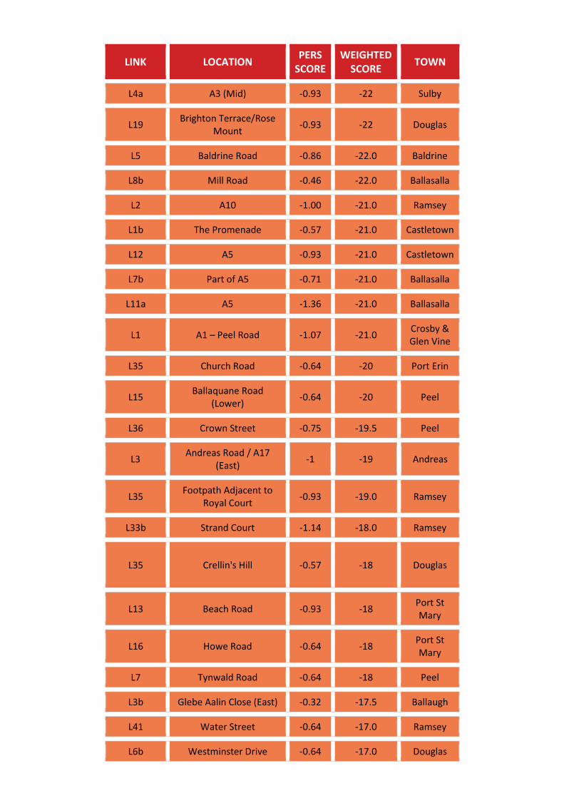
LINK LOCATION PERS
SCORE WEIGHTED
SCORE TOWN
L4a A3 (Mid) -0.93 -22 Sulby
L19 Brighton Terrace/Rose
Mount -0.93 -22 Douglas
L5 Baldrine Road -0.86 -22.0 Baldrine
L8b Mill Road -0.46 -22.0 Ballasalla
L2 A10 -1.00 -21.0 Ramsey
L1b The Promenade -0.57 -21.0 Castletown
L12 A5 -0.93 -21.0 Castletown
L7b Part of A5 -0.71 -21.0 Ballasalla
L11a A5 -1.36 -21.0 Ballasalla
L1 A1 – Peel Road -1.07 -21.0 Crosby & Glen Vine
L35 Church Road -0.64 -20 Port Erin
L15 Ballaquane Road
(Lower) -0.64 -20 Peel
L36 Crown Street -0.75 -19.5 Peel
L3 Andreas Road / A17
(East) -1 -19 Andreas
L35 Footpath Adjacent to
Royal Court -0.93 -19.0 Ramsey
L33b Strand Court -1.14 -18.0 Ramsey
L35
Crellin's Hill
-0.57 -18 Douglas
L13 Beach Road -0.93 -18 Port St Mary
L16 Howe Road -0.64 -18 Port St Mary
L7 Tynwald Road -0.64 -18 Peel
L3b Glebe Aalin Close (East) -0.32 -17.5 Ballaugh
L41 Water Street -0.64 -17.0 Ramsey
L6b Westminster Drive -0.64 -17.0 Douglas
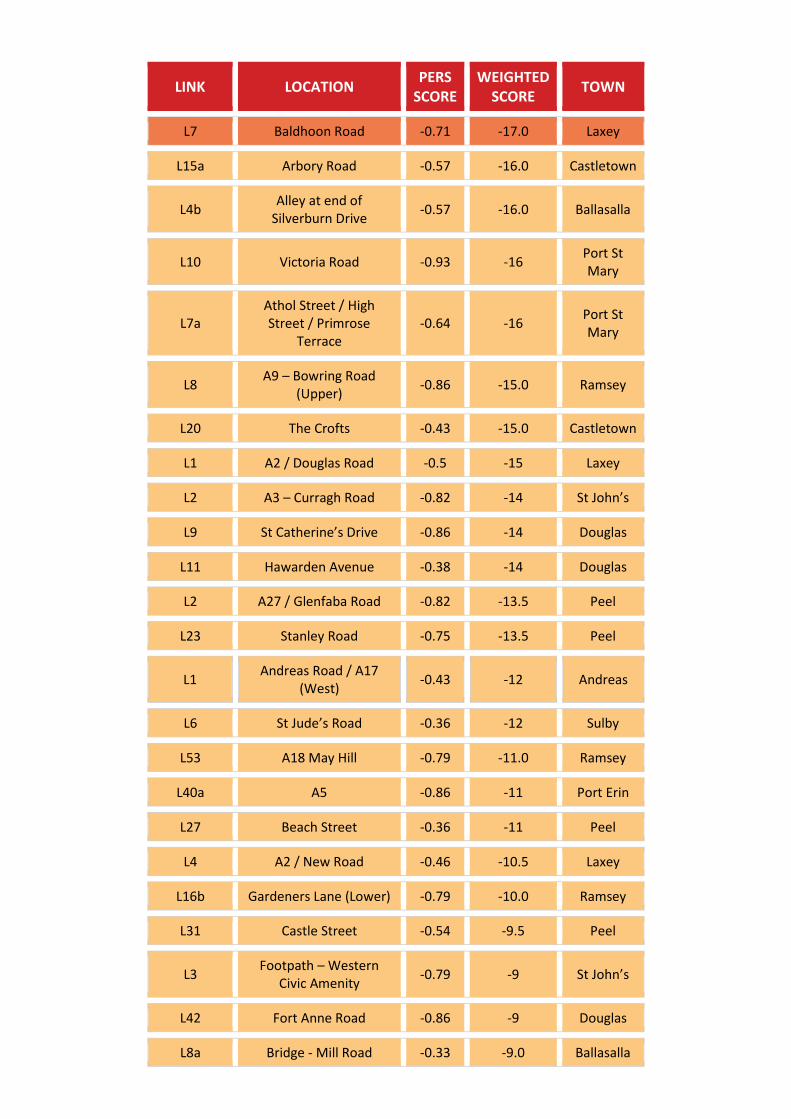
LINK LOCATION PERS
SCORE WEIGHTED
SCORE TOWN
L7 Baldhoon Road -0.71 -17.0 Laxey
L15a Arbory Road -0.57 -16.0 Castletown
L4b Alley at end of
Silverburn Drive -0.57 -16.0 Ballasalla
L10 Victoria Road -0.93 -16 Port St Mary
L7a Athol Street / High Street / Primrose
Terrace -0.64 -16
Port St Mary
L8 A9 – Bowring Road
(Upper) -0.86 -15.0 Ramsey
L20 The Crofts -0.43 -15.0 Castletown
L1 A2 / Douglas Road -0.5 -15 Laxey
L2 A3 – Curragh Road -0.82 -14 St John’s
L9 St Catherine’s Drive -0.86 -14 Douglas
L11 Hawarden Avenue -0.38 -14 Douglas
L2 A27 / Glenfaba Road -0.82 -13.5 Peel
L23 Stanley Road -0.75 -13.5 Peel
L1 Andreas Road / A17
(West) -0.43 -12 Andreas
L6 St Jude’s Road -0.36 -12 Sulby
L53 A18 May Hill -0.79 -11.0 Ramsey
L40a A5 -0.86 -11 Port Erin
L27 Beach Street -0.36 -11 Peel
L4 A2 / New Road -0.46 -10.5 Laxey
L16b Gardeners Lane (Lower) -0.79 -10.0 Ramsey
L31 Castle Street -0.54 -9.5 Peel
L3 Footpath – Western
Civic Amenity -0.79 -9 St John’s
L42 Fort Anne Road -0.86 -9 Douglas
L8a Bridge - Mill Road -0.33 -9.0 Ballasalla
LINK LOCATION PERS
SCORE WEIGHTED
SCORE TOWN
L7 Ballaoates Road -0.57 -8 Union Mills & Strang
L41a South Quay
-0.57 -7 Douglas
L12 Port-E-Chee Avenue -0.5 -7 Onchan
L24b Hope Street -0.29 -7.0 Castletown
L5 Rencell Hill / Old School
Road / Lhergy Grawe -0.57 -7 Laxey
L4 A2 - North -0.93 -6.5 Baldrine
L52 Stanley Mount West -0.50 -6.0 Ramsey
L29 St George Road
-0.86 -6 Douglas
L7b Station Road -0.29 -6 Port St Mary
L40 Wybourn Drive -0.5 -5 Onchan
L5a Glen Vine Road -0.43 -5.0 Crosby & Glen Vine
L3a Tent Road -0.5 -5 Laxey
L5 Footpath adjacent to
Foxdale School -1.00 -4.00 Foxdale
L43 Christian Street -0.14 -3.0 Ramsey
L2 Cronk Road / Lhergy
Cripperty -0.36 -3
Union Mills & Strang
L4 Athol Park -0.57 -3 Port Erin
L1 Ballamenagh Road -0.54 -3.0 Baldrine
L15b Arbory Road -0.21 -3.0 Castletown
L27 Castle Street -0.14 -3.0 Castletown
L31b Farrants Way -0.64 -3.0 Castletown
L46b Unnamed Road between
Maple Avenue and School Road
-0.46 -1.5 Onchan
LINK LOCATION PERS
SCORE WEIGHTED
SCORE TOWN
L3b Strand Road -0.25 -1.5 Port Erin
L28 Cronk Hunna -0.43 -1.5 Port Erin
L13 Cumberland Road -0.43 -1.0 Ramsey
L10 Windsor Mount -0.21 -1.0 Ramsey
L9 Alley to Bowling Green
Road and Douglas Street -0.43 -1.0 Castletown
L5 Devonshire Road -0.57 0 Douglas
L38 Ballagawne Road -0.14 0 Port Erin
L13 Kinnish Terrace (B) -0.57 0.0 Ballasalla
L41b South Quay -0.36 1 Douglas
L52 Cushag Road -0.29 1 Douglas
L4 A1 – Peel Road -0.50 1.0 Crosby & Glen Vine
L10 A26 - Glen Darragh Road 0.00 1.0 Crosby & Glen Vine
L37a Little Switzerland -0.32 1.5 Onchan
L37 Orry Lane / Queen
Street / Beach Street -0.25 1.5 Peel
L7 Ballabrooie Way -0.5 2 Douglas
L2 Exit from A5 leading to
Balthane Industrial Estate
-0.57 2.0 Ballasalla
L1b Clifton Road - North -0.57 2 Port St Mary
L18a A32 -0.39 2.5 Port Erin
L36 A38 - Ballakilloway -0.39 2.5 Port Erin
L58 Laury’s Avenue -0.07 3.0 Ramsey
L26 Bowring Road -0.21 3.0 Ramsey
L25 Kensington Road -0.43 3 Douglas
L33 Christian Road
-0.57 3 Douglas
L65 Vicarage Road -0.21 3 Douglas
LINK LOCATION PERS
SCORE WEIGHTED
SCORE TOWN
L37 Castletown Road 0 3 Port Erin
L2 Station Road -0.36 3 Colby
L29 Quayside and the Quay 0.07 3.0 Castletown
L3a Station Road – A5 -0.64 3.0 Ballasalla
L40 Mountain View -0.54 3.5 Peel
L26 Bridge Street / Duke
Street -0.25 3.5 Peel
L5b A5 – Adjacent to
Ronaldsway Airport -0.21 4.0 Castletown
L21a A4 East (Upper) -0.5 4 Peel
L52 Derwent Drive /
Buttermere Drive -0.25 4.5 Onchan
L14 Alexander Drive -0.36 5 Douglas
L58 Farmhill Lane -0.07 5 Douglas
L4 Glenfaba Park -0.29 5 Peel
L23 Conister Road -0.54 5.5 Onchan
L2 Lime Street -0.18 5.5 Port St Mary
L12 Marshen Cresent -0.36 6 Port Erin
L23 Ballagale Avenue -0.57 6 Port Erin
L6 Bride Road (South) -0.5 7 Andreas
L31 Market Street
0.14 7 Douglas
L61b Ridgeway Road -0.5 7 Onchan
L22b A4 West (Lower) /
Christian Street -0.11 7.5 Peel
L51 Walpole Drive -0.07 8.0 Ramsey
L6 Packhorse Lane (Upper) -0.36 8.0 Baldrine
L8b Douglas Street 0.00 8.0 Castletown
L13 A3 -0.36 8.0 Castletown
L24 School Road -0.18 8.5 Onchan
LINK LOCATION PERS
SCORE WEIGHTED
SCORE TOWN
L26c Upper Church Street -0.71 9 Douglas
L9 A1 – Peel Road -0.43 9.0 Crosby & Glen Vine
L57 Kirkway / Howstrake Drive / Central Drive
-0.11 9.5 Onchan
L2b A24 -0.21 10 Foxdale
L51 A24 - Cooil Road 0 10 Douglas
L7b Erin Close -0.14 10 Port Erin
L4 Main Road / A3 (East) -0.36 10 Ballaugh
L39b Lord Street
0.14 11 Douglas
L1a A40 – Station Road -0.29 11 St John’s
L1 A10 -0.29 11 Ballaugh
L40 Harbour Bridge
-0.29 12 Douglas
L9 Lower Rencell /
Captain's Hill -0.14 12 Laxey
L9a Kionslieu Road -0.43 12 Foxdale
L17 Ballaquane Park -0.46 12.5 Peel
L11 A21 – Ballafletcher Road -0.57 13 Union Mills & Strang
L3a Glenn View / St Georges
Cresent -0.21 13 Port Erin
L2 Ballafurt Road -0.25 13.5 Port Erin
L6 Erin Way -0.11 13.5 Port Erin
L5 Leodest Road -0.36 15 Andreas
L8 Oatlands Road -0.36 15 Andreas
L4b A3 (West) -0.07 15 Sulby
L11b A5 -0.29 15.0 Ballasalla
L12a Derby Road -0.14 15 Peel
LINK LOCATION PERS
SCORE WEIGHTED
SCORE TOWN
L43 Hillcrest Grove +
Footpath -0.11 15.5 Onchan
L30 Market Street -0.04 15.5 Peel
L4 A22 – Strang Road -0.14 17 Union Mills & Strang
L5b A7 0.14 17.0 Ballasalla
L47 A18 May Hill -0.21 18.0 Ramsey
L5a A5 – Adjacent to
Ronaldsway Airport 0.14 18.0 Castletown
L6b A1 – Peel Road 0.11 18.5 St John’s
L48 School Road 0 19.5 Onchan
L4 Access from A24 –
Walkthrough to Residential properties
-0.71 21.0 Foxdale
L4 Ballakermeen Drive -0.29 21 Douglas
L14
Unnamed Road (Junction north of
Ballanard Road / Johnny Watterson Lane
roundabout)
0 21 Onchan
L25 Bank Street/Thirtle
Bridge 0.07 21.0 Castletown
L24 Derby Drive -0.32 21.5 Peel
L10 Dumbells Row / Mines
Road 0.25 21.5 Laxey
L15 Albany Road -0.14 22 Douglas
L73 Pulrose Road 0 22 Douglas
L5 Droghadfayle Park -0.11 22.5 Port Erin
L7 Sprucewood
View/Close/Rise 0.14 23.0 Foxdale
L48 Queen’s Pier Road -0.29 23.0 Ramsey
L44 Ridgeway Street 0.14 23 Douglas
LINK LOCATION PERS
SCORE WEIGHTED
SCORE TOWN
L33 Scarlett Road near
Knock Rushen -0.14 23.0 Castletown
L34 Footpath and Scarlett
Road -0.14 23.0 Castletown
L3b Shore Road 0.07 23 Laxey
L1a A3 – Foxdale Road 0.07 24.0 Foxdale
L7 Andreas Road / A9
(West) -0.07 24 Andreas
L50 Queen’s Drive East and
West -0.29 24.0 Ramsey
L50 A24 - Cooil Road -0.07 24 Douglas
L55 Ballaughton Villas 0.07 24 Douglas
L49 Nursery Avenue -0.21 24 Onchan
L3b Stanley Close 0.64 24.0 Castletown
L11a Promenade / Sea Front 0 24 Port St Mary
L62 Strathallan Road / Hague Crescent / Imperial Terrace
0.32 24.5 Onchan
L32 Finch Road/ Mona
Terrace
-0.07 25 Douglas
L55 Church Road 0 25 Onchan
L9a Rear access to Barrule
Drive 0.07 25.0 Ballasalla
L14 A29 / Four Roads 0.21 25 Port St Mary
L11 Walkthrough to Avon
Lodge and other residential properties
0.14 26.0 Foxdale
L44 Claughbane
Drive/Brookfield Avenue -0.5 26.0 Ramsey
L45b Bank Hill 0 26 Douglas
LINK LOCATION PERS
SCORE WEIGHTED
SCORE TOWN
L22 Snaefell Road /
Willaston Crescent / Barrule Road
0.07 26 Onchan
L36 Kissack Road -0.14 26.0 Castletown
L16a Woodbourne Road 0.29 27 Douglas
L11 Cronk Liauyr / Cronk Ny Greiney / Sileau Dhoo /
Tromode Park -0.21 27 Onchan
L1a Clifton Road 0.29 27 Port St Mary
L28 Hill Street
0.21 28 Douglas
L9 Tromode Road 0 28.5 Onchan
L19 Gladstone Avenue -0.29 29.0 Ramsey
L10 Westbourne Drive 0.23 29 Douglas
L35 Close Rushen and
Farrants Park 0.29 29.0 Castletown
L13a Kerroo Coar / Rheast
Brisdon 0.29 29 Peel
L74 Springham Park 0.14 30 Douglas
L31 Ballafesson Road 0.29 30 Port Erin
L10 A5 0.43 30.0 Castletown
L23a Malew Street 0.14 30.0 Castletown
L3b Station Road – A5 0.14 30.0 Ballasalla
L21 Rowany Drive 0.18 30.5 Port Erin
L8 Konsilieu Terrace 0.43 31.0 Foxdale
L14 Grove Mount South 0.29 31.0 Ramsey
L7a A26 0.21 31.0 Ballasalla
L12 Slieawhallin Park 0.07 32 St John’s
L54 Turnberry Avenue /
Banks Howe 0.14 32 Onchan
L1 A7 0.5 32 Colby
LINK LOCATION PERS
SCORE WEIGHTED
SCORE TOWN
L38 Tower Road -0.07 33.0 Ramsey
L71 Groves Road 0.36 33 Douglas
L30a Along Sulby River 0.21 34.0 Ramsey
L30 Ballafesson Road 0.07 34 Port Erin
L22b Arbory Street 0.29 34.0 Castletown
L19 Tynwald Road -0.07 34.5 Onchan
L19 Mann Road 0.29 35 Port Erin
L32 Mill Road / Station Road 0.21 35 Peel
L16 Ballaquane Road
(Upper) 0.25 35.5 Peel
L39c Peel Road
0.07 36 Douglas
L33a A18 0.43 36 Onchan
L12 Promenade (Road) 0.07 36 Port St Mary
L8 Lyndale Avenue 0.14 37 Peel
L38 Walpole Road 0.18 37.5 Peel
L1b A40 – Station Road 0.36 38 St John’s
L29 Bridge 0.79 38.0 Ramsey
L21b A4 East (Lower) -0.14 38 Peel
L38a Peveril Square/Loch
Promenade 0.57 39 Douglas
L8 Ballamaddrell 0.14 39 Port Erin
L10 Cronk Cullyn 0.36 39 Colby
L7 Ballacriy Park 0.07 39 Colby
L18 School Hill Avenue and
part of West Hill Avenue 0.07 39.0 Castletown
L39 West View 0.29 39 Peel
L32 South Promenade 0.07 40.0 Ramsey
LINK LOCATION PERS
SCORE WEIGHTED
SCORE TOWN
L6a Path approaching
Ballakermeen High School
0.21 40 Douglas
L42 Highfield Crescent 0.32 40.5 Onchan
L5 Heathfield Drive /
Queens Drive 0.39 40.5 Peel
L54 Lheaney Road 0.07 41.0 Ramsey
L7a Erin Way 0.25 41.5 Port Erin
L12b Derby Road 0.43 42 Peel
L1 A1 – Peel Road 0.61 42.5 Union Mills & Strang
L21 Lezayre Road 0.50 43.0 Ramsey
L24 Desmene Road 0.29 43 Douglas
L8 Quarter Bridge Road 0.14 43 Onchan
L63 King Edward Road
Middle 0.14 43 Onchan
L14 A5 0.86 43.0 Castletown
L12 Kinnish Terrace 0.46 43.0 Ballasalla
L1b A3 – Foxdale Road 0.36 44.0 Foxdale
L46 Prince’s Road/Laury’s
Avenue 0.29 44.0 Ramsey
L22 Hillside Avenue 0.14 44 Douglas
L63 Ballaughton Manor Hill 0.43 44 Douglas
L20 Baldwin Road +
Footpath 0.36 44 Onchan
L26 Julian Road / Glen Park
Drive / Footpath 0.29 44 Onchan
L17 Church Road 0.61 44.5 Port Erin
L5 Thornhill Park leading to
Clifton Road 0.14 45 Ramsey
L18 Albert/Albion Terrace 0.29 45 Douglas
L51 Windermere Drive 0.29 45 Onchan
LINK LOCATION PERS
SCORE WEIGHTED
SCORE TOWN
L17 Footpath along The
Buchan School 0.07 45.0 Castletown
L17 Greenlands Avenue 0.36 46.0 Ramsey
L53 Hibbin Avenue 0.57 46 Douglas
L11b Gansy Road / Upper
Promenade 0.64 46
Port St Mary
L59 Farmhill Park 0.57 47 Douglas
L45b Ashley Park / Second
Avenue 0.43 47 Onchan
L3 Mooraugh Promenade 0.43 48.0 Ramsey
L16 Bayr Grianagh 0.36 48.0 Castletown
L18 Belle Vue Park 0.5 48 Peel
L10 Snaefell Road 0.18 49.5 Onchan
L20 Lezayre Road Path 0.50 50.0 Ramsey
L6 Mount Rule Road 0.71 50 Union Mills & Strang
L47b Old Castletown Road 0.57 50 Douglas
L54 Anagh Coar Road 0.64 50 Douglas
L3 Victoria Road 0.43 50 Onchan
L7 College Green 0.57 50.0 Castletown
L56 King Edward Road East 0.32 50.5 Onchan
L9 A9 – Bowring Road
(Lower) 0.36 51.0 Ramsey
L12 Selborne Road 0.5 51 Douglas
L10 Bride Road (North) 0.29 52 Andreas
L9 Nobles Hospital 1 52 Union Mills & Strang
L61 Meadow Crescent 0.5 52 Douglas
L6 Shore Road 0.29 52.0 Castletown
L26a Victoria Road 0.50 52.0 Castletown
LINK LOCATION PERS
SCORE WEIGHTED
SCORE TOWN
L3 Queens Road (South) 0.36 52 Port St Mary
L23a Bircham Avenue Close/Park Ollay
0.21 53.0 Ramsey
L53 Groudle Road 0.86 53 Onchan
L6 Archallagan Terrace 0.36 54 Foxdale
L3b Springfield Rise 0.43 54 Foxdale
L4 Larivane Close 0.57 54 Andreas
L49 Beaumont Road 0.43 54.0 Ramsey
L41 Victoria Avenue / Mount
View Close / Fairfield Avenue
0.57 54 Onchan
L6 Fistard Road Lower 0.43 54 Port St Mary
L29 Charles Street / Queens
Street 0.57 54 Peel
L4 Ballaquayle Road/Drury
Terrace/Stanley Terrace/Broadway
0.25 54.5 Onchan
L57 Stevenson Way 0.21 55 Douglas
L3 A1 – Main Road / Ballahutchin Hill
0.57 56 Union Mills & Strang
L23b Tynwald Street 0.5 56 Douglas
L16c Victoria Street 1.14 57 Douglas
L32 Magherrosien / Maghergarran
0.71 57 Port Erin
L9b Kionslieu Road 0.71 57 Foxdale
L22 Ocean Castle Drive -1.68 57.5 Port Erin
L18 Greenfield Road 0.54 58.5 Onchan
L5 Magher Vay 0.93 59 St John’s
L16b Bucks Road 0.5 59 Douglas
LINK LOCATION PERS
SCORE WEIGHTED
SCORE TOWN
L68 Isle of Man Business
Park 0.64 59 Douglas
L11 Ballacloan Road 0.79 60.0 Ramsey
L1 The Promenade 0.86 60 Onchan
L1a The Promenade 0.43 61.0 Castletown
L59 Alberta Drive 0.68 61.5 Onchan
L36 Waterloo Road 0.64 62.0 Ramsey
L13 Selborne Road 0.57 62 Douglas
L64 King Edward Road West
/ Port Jack 0.64 62 Onchan
L5 Thorny Road 0.75 62.5 Onchan
L35 Governor's Road / A2 0.96 63.5 Onchan
L1 A1 0.89 63.5 Peel
L39a Lord Street
0.86 64 Douglas
L11 Road to Castletown
Railway Station 1.07 64.0 Castletown
L25 Church Street 0.79 64 Peel
L34 West Quay 0.86 64 Peel
L33b Avondale Road /
Hillberry Road 0.68 64.5 Onchan
L6 A2 (north-west) 1.32 64.5 Laxey
L10 Yn Claddagh (Mid West) 1 65 Sulby
L7 Somerset Road 0.32 65.5 Onchan
L31 Market Hill/Dale Street 1.07 66.0 Ramsey
L60 Meadow Crescent 0.86 66 Douglas
L6a Ballacriy Park 0.71 66 Colby
L4a Silverburn Drive 0.93 66.0 Ballasalla
L8 A23 – Braddan Road 0.93 67 Union Mills & Strang
LINK LOCATION PERS
SCORE WEIGHTED
SCORE TOWN
L3a Alley between Orry
Place and James Road 1.00 67.0 Castletown
L15 Old River Road 0.71 68.0 Ramsey
L15 York Road 0.64 68 Onchan
L2 Palace Road / Empress
Drive 1 68.5 Onchan
L6 Albany Road 0.68 68.5 Peel
L27 North Shore Road 0.71 69.0 Ramsey
L24b Poyll Dooey Road 0.71 69.0 Ramsey
L10 A23 - Braddan Road 0.71 69 Union Mills & Strang
L31a Farrants Way 0.71 69.0 Castletown
L17 Derby Road 0.5 70 Douglas
L23a Hillside Terrace 0.93 70 Douglas
L47a South Quay 0.57 70 Douglas
L17 Dukes Avenue / Dukes
Road 0.89 70.5 Onchan
L22a A4 West (Upper) 0.64 71 Peel
L10 Michael Street 1.04 71.5 Peel
L34 Queens Promenade 0.93 72.0 Ramsey
L18 Poyll Dooey Road 0.79 72.0 Ramsey
L65 A2 West 0.61 72.5 Onchan
L6 Woodbourne Road 0.5 73 Onchan
L64 B27 Saddle Road 0.93 74 Douglas
L30 Hailwood Avenue 0.86 74 Onchan
L14 Lhag Mooar 1 74 Port Erin
L11 Albany Close / Kerroo
Coar 0.96 74 Peel
L2 Ballaterson Fields 1 74 Ballaugh
L7 Yn Arrey 0.86 76 Sulby
LINK LOCATION PERS
SCORE WEIGHTED
SCORE TOWN
L48 Lake Road 1.14 76 Douglas
L56 Cushag Road/Annacur
Lane 0.93 76 Douglas
L75 Barley Field Road 1.14 76 Douglas
L16 Footpath through
Nobles Park 0.89 76.5 Onchan
L55 Barrule Park 0.93 77.0 Ramsey
L12 Park Road 0.93 77.0 Ramsey
L4 Rheast Mooar Avenue 1.07 78.0 Ramsey
L16a Gardeners Lane (Upper) 0.79 78.0 Ramsey
L5 Ballanawin / Cronk
Grianagh 0.86 78
Union Mills & Strang
L26b Upper Church Street 0.5 78 Douglas
L69 Springfield Road 1 78 Douglas
L34 Unnamed Road between
A2 and A18 1.11 78.5 Onchan
L27 Cronk Drean / Second
Avenue 1.04 79 Onchan
L58 Royal Avenue 0.86 80 Onchan
L5b Ballacriy Park 1 80 Colby
L3 Ballatessan Meadow 1.36 80 Peel
L42 Bay View Road 1.18 80.5 Port Erin
L35 A27 / Town Centre 1.61 80.5 Peel
L39 Albert Street 1.21 81.0 Ramsey
L72 New Castletown Road 0.86 81 Douglas
L46a Maple Avenue 1.14 81 Onchan
L7 St Rinius Way 1.00 81.0 Crosby & Glen Vine
L6 King Orry Road 1.00 81.0 Crosby & Glen Vine
LINK LOCATION PERS
SCORE WEIGHTED
SCORE TOWN
L61a Ridgeway Road / The Park / Belgravia Road
1.29 82 Onchan
L34 Church Road 1.14 82 Port Erin
L9 Cronk Y Thatcher 0.93 82 Colby
L8 Ballagarey Road 1.14 82.0 Crosby & Glen Vine
L33a St Paul’s Square 1.00 83.0 Ramsey
L25 Station Road 1.07 83.0 Ramsey
L30b West Quay 1.14 84.0 Ramsey
L15 Bridson Street 1.29 84 Port Erin
L9b Balthane Square
1.14 84.0 Ballasalla
L47 Ballachrink Drive 1.18 84.5 Onchan
L28 Lakeside Road 1.32 85.5 Onchan
L9 Athol Street 1.18 85.5 Peel
L37b Harris Promenade
1 86 Douglas
L67 Vicarage Road 1.21 86 Douglas
L60 Summer Hill Road 1.32 86.5 Onchan
L57 Claughbane Drive 1.43 87.0 Ramsey
L32 A2 East 1.25 87.5 Onchan
L11 Castletown Road 1.54 87.5 Port Erin
L30c Market Place 1.14 89.0 Ramsey
L21 Peel Road 1.07 89 Douglas
L66 Vicarage Road 1.21 89 Douglas
L28 Cain Bridge 1.64 89.0 Castletown
L70 Alder Riad 1.21 90 Douglas
L3a Glebe Aalin Close (West) 1.21 90 Ballaugh
L24a Bircham Avenue 1.14 91.0 Ramsey
L27 Circular Road 0.71 91 Douglas
LINK LOCATION PERS
SCORE WEIGHTED
SCORE TOWN
L29 Lakeside Road /
Belgravia 1.43 91 Onchan
L13 A7 - Ballaffesson Road
(South) 1.39 91.5 Port Erin
L3a Springfield Rise 1.29 92.0 Foxdale
L49 Old Castletown Road 1.14 92 Douglas
L33 East Quay 1.68 92.5 Peel
L37a Loch Promenade
1.29 93 Douglas
L31 Governors Hill / Hill
Croft / Campion Way 1.64 94 Onchan
L19 Oak Road 1.43 94 Peel
L28 Mooragh Promenade 1.50 95.0 Ramsey
L4 Queens Road (North) 1.29 95 Port St Mary
L45 A18 Queen’s Pier Road 1.36 96.0 Ramsey
L22 Lezayre Road (East) 1.57 97.0 Ramsey
L30 Athol Street
1.29 98 Douglas
L22a Arbory Street – Pedestrian Area
1.71 98.0 Castletown
L20 Raad Darragh 1.43 99 Peel
L39 Heywood Avenue 1.71 100 Onchan
L10 Whitestone Terrace 1.57 100.0 Ballasalla
L25 Johnny Watterson Lane 1.5 102 Onchan
L4 King Williams Way 1.57 104.0 Castletown
L16d Victoria Street 1.5 106 Douglas
L42 Parliament Street 1.86 107.0 Ramsey
L28 Shore Road / Marine
Parade 1.71 108 Peel
L13 Ballanard Road 1.39 108.5 Onchan
LINK LOCATION PERS
SCORE WEIGHTED
SCORE TOWN
L26a Westmoreland Road 1.79 110 Douglas
L2 James Road 1.79 112.0 Castletown
L1 Peel Road 1.79 113 Douglas
L38b Walpole Avenue 1.79 113 Douglas
L36 Strand Street
1.93 114 Douglas
L8a Glen Road East 1.93 114 Laxey
L9 Promenade 1.86 115 Port Erin
L36 Blackberry Lane 1.79 117 Onchan
L13b Fuchsia Road / Campion
Crescent 2 118 Peel
L23b Pairk Ollay 1.93 119.0 Ramsey
L2 Peel Road 1.79 119 Douglas
L8 Cronk Cullyn 2.14 124 Colby
L16a Orchard Road (Lower) 2.25 124.5 Port Erin
L45a Bridge Road 2.07 127 Douglas
L43 North Quay 2.29 128 Douglas
L50 A2 / Whitebridge Road 2.07 129 Onchan
L10 A32 - Station Road 2.39 129.5 Port Erin

SYSTRA provides advice on transport, to central, regional and local government, agencies, developers, operators and financiers.
A diverse group of results-oriented people, we are part of a strong team of professionals worldwide. Through client business planning, customer research and strategy development we create solutions that work for real people in the real world.
For more information visit www.systra.co.uk