Embed Size (px)
Citation preview

PHYSIOGRAPHIC PROVINCES AND SECTIONS IN WESTERN OKLAHOMA AND ADJACENT PARTS OF TEXAS.
By NE.VIN M. FENNEMAN.
GENERAL FEATURES OF THE AREA.
Physiographic provinces. The area here considered is a part of the interior plains of the United States, which is an extensive region of relatively slight relief and nearly horizontal beds of rock that is divided between the Great Plains province, its western part, and the Central Lowland, its eastern part. The boundary between these two physiographic provinces runs in general southward and lies not far from the one hundredth meridian the meridian that forms the eastern boundary of the Texas " panhandle."
The most obvious difference between the Great Plains and the Central Lowland is one of altitude, for the plains are generally about 2,000 feet above sea level near their eastern edge and increase in height toward the west, whereas the lowland is everywhere below 2,000 feet. The boundary line between the provinces throughout most of its extent is drawn at the foot of an escarpment, or at least at the foot of an eastward slope, which is steeper than the average slope from the Eocky Mountains to Mississippi Eiver. At some places it is clear that the lowland is expanding westward by con tinued erosion and that the escarpment which separates the plains and the lowland is retreating westward, and it is therefore evident that the lower surface of that part of the Central Lowland has been produced by the wearing down of the Great Plains, which formerly extended farther east.
Both the Great Plains and the Central Lowland may be divided into sections that differ somewhat in topography. Those represented in this area are the High Plains section of the Great Plains and the Osage section of the Central Lowland.
High Plains section of the Great Plains. The High Plains are remnants of a once continuous plain whose surface was formed of Tertiary silt, sand, and gravel. This plain stretched from the Rocky
115
116 CONTRIBUTIONS TO GEOGRAPHY OF UNITED STATES,
Mountains eastward beyond the present limits of the Great Plains, at a slope of not more than 10 feet to the mile. This once broad belt has been narrowed by erosion on both sides and is crossed from west to east by a few rivers, ( which have cut deep valleys, but the remnants of the original plain still dominate the landscape in the belt that is called the High Plains section.
These plains are typically exemplified in the Texas " panhandle," which lies along the western margin of the1 area herein described. Their treeless surface is essentially flat except for some valleys eroded near their eastern edge and near the large streams. They include also some wide, shallow depressions, some of which con tain lakes, but none of these features are sufficiently pronounced to offset the general impression of flatness.
Generally along the eastern edge of the High Plains section there is a steep slope down to the Central Lowland. Throughout much of its extent this steep slope is an actual escarpment the " break of the plains " 300 to 600 feet high, at some places straight, at others made irregular by the erosion of streams that head in the plateau and flow eastward.
Osage section of the Central Lowland. The southwestern part of the Central Lowland, known as the Osage section, shows throughout its extent the character of a surface produced by degradation. The formations dip slightly toward the west or northwest and have been planed off, so that their edges crop out in belts that trend nearly southward. The outcropping edges of the more resistant members give rise to eastward-facing escarpments, which are generally 50 to 200 feet high. All these escarpments have been more or less dis sected, some of them so much that hilly belts several miles wide have taken the place of what may once have been simple escarp ments. On the intervening less resistant formations, most of them composed of shale, are broad, smooth surfaces. The alternation of these two types of topography is sufficiently common to suggest the term "scarped plains," which is often applied to the Osage section.
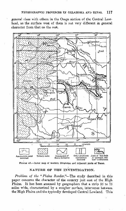
Several of the escarpments are exceptionally high and rugged. One, between Cimarron and Canadian rivers, in western Oklahoma, which marks the outcrop belt of the Blaine formation (fig. 43), extends from the Kansas boundary southeastward halfway across the State and is the most prominent of the several hilly tracts bear ing the name Gypsum Hills. The other high escarpments lie mainly in Texas and die out toward the north in the vicinity of Eed River. The highest and most rugged of these escarpments, which is made by beds of resistant limestone, lies a little west of the ninety-ninth meridian. Although these escarpments contrast strongly in topog raphy with the smooth plains on either side, they belong to the same
PHYSIOGRAPHIC PROVINCES IN OKLAHOMA AND TEXAS. 117
general class with others in the Osage section of the Central Low land, as the surface west of them is not very different in general character from that on the east.
Approximate route" Tertiary rocks traversed
Escarpment of Other prominent .Limit of "Red BedsBlaine formation escarpments of uncertain rela-
described 'tion" in Oklahoma
FIGURE 43. Index map of western Oklahoma and adjacent parts of Texas.
NATURE OF THE INVESTIGATION.
Problem of the ' ''Plains Border" The study described in this paper concerns the character of the country just east of the High Plains. It has been assumed by geographers that a strip 25 to 75 miles wide, characterized by a rougher surface, intervenes between the High Plains and the typically developed Central Lowland. This
118 CONTRIBUTIONS TO GEOGRAPHY OF UNITED STATES,
strip has been called the " Plains Border " and classed as a section of the Great Plains province. It has been defined as follows:
Consider these plains [the High Plains in their original extent] to have been a uniform smooth surface stretching from the mountains to eastern Nebraska and Kansas. The central strip or High Plains [section] is what is left of this flat surface, still covered by the late Tertiary beds to which the flatness is due. The Plains Border is the strip on the east from which the Ter tiary mantle has been in large part eroded and which is now dissected but not reduced to the low relief which characterizes the Central Lowland. It is in general a hilly country.1
This description was written with immediate reference to the part of the province lying in the latitude of Kansas. From the scanty physiographic information available for western Oklahoma and adjacent parts of Texas it was inferred that a similar division of the Great Plains province was applicable also to that region.
In the paper cited above it was assumed that the eastern front of the Gypsum Hills from the Kansas boundary to central Texas con stitutes a fairly definite boundary between the typical lowlands of the Osage section on the east and a rougher region, less perfectly base-leveled, on the west. It was to test this assumption that the field investigation here recorded was undertaken. The question to be answered was: Should a distinct physiographic section be recog nized between the High Plains and the Central Lowland in western Oklahoma and northern Texas?
Manifestly the boundary between a high plain and a continuous low plain can nowhere be merely a line, even if so represented on a map, and it must therefore be assumed that the two are separated by at least a narrow transitional belt, roughened by dissection but not base-leveled, even if such a belt has not been specifically men tioned. The propriety of treating this rougher strip as a distinct physiographic section depends partly on its width.
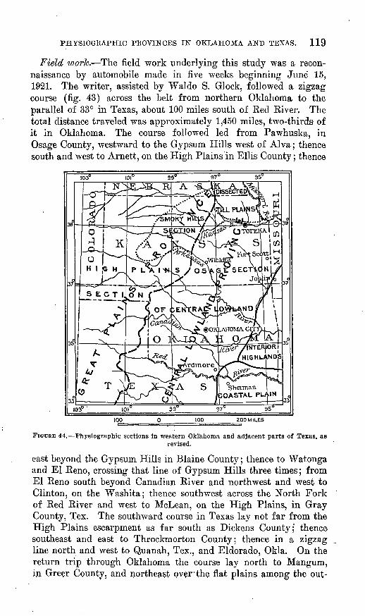
Conclusions. It may be stated in advance that the result of the field investigation has led to the conclusions that the lower area next east of the High Plains has a generally uniform character from east to west and that it should not be divided and its parts allotted to different provinces. It is also doubtful whether any contrast between its eastern and western parts is sufficient to justify the setting up of two sections. Future detailed studies will probably enable the physiographer to recognize several divisions of a lower order, and in delimiting these divisions the minor scarps should doubtless be considered. The provinces and sections, as revised through this investigation, are shown in figure 44, in which the name " Smoky Hills section " is applied to what remains of the " Plains Border."
1 Assoc. Am. Geographers Annals, vol. 6, p. 70, 1917.
PHYSIOGRAPHIC PROVINCES IN OKLAHOMA AND TEXAS. 119
Field work. The field work underlying this study was a recon naissance by automobile made in five weeks beginning June 15, 1921. The writer, assisted by Waldo S. Glock, followed a zigzag course (fig. 43) across the belt from northern Oklahoma to the parallel of 33° in Texas, about 100 miles south of Eed River. The total distance traveled was approximately 1,450 miles, two-thirds of it in Oklahoma. The course followed led from Pawhuska, in Osage County, westward to the Gypsum Hills west of Alva; thence south and west to Arnett, on the High Plains in Ellis County; thence
ZOO MILES
FIGDRH 44. Physiographic sections in western Oklahoma and adjacent parts of Texas, asrevised.
east beyond the Gypsum Hills in Blaine County; thence to Watonga and El Reno, crossing that line of Gypsum Hills three times; from El Reno south beyond Canadian River and northwest and west to Clinton, on the Washita; thence southwest across the North Fork of Red River and west to McLean, on the High Plains, in Gray County, Tex. The southward course in Texas lay not far from the High Plains escarpment as far south as Dickens County; thence southeast and east to Throckmorton County; thence in a zigzag line north and west to Quanah, Tex., and Eldorado, Okla. On the return trip through Oklahoma the course lay north to Mangum, in Greer County., and northeast over the flat plains among the out-
120 .CONTRIBUTIONS TO GEOGEAPHY OF UNITED STATES,. 1922.
lying granite knobs of the Wichita Mountains; thence, after a north ward detour over the more rolling surface of Washita County, east to Anadarko and Chickasha, north to El Eeno, and east to, Okla homa City. The work was necessarily of reconnaissance character and insufficient to justify a full discussion of the physiography of the region, but the above outline of the route will enable those who are familiar with any of the broad areas that lie between the lines traversed to judge whether it is adequate and representative.
TOPOGRAPHY ON THE SEVERAL FORMATIONS.
FORMATIONS RECOGNIZED.
There is no marked contrast between the eastern and western parts of the area traversed with respect to the presence of nearly flat surfaces interpreted as remnants of a peneplain. The extent and flatness of such surfaces differs somewhat with the character of the underlying rock. The following formations are recognized in the area described:Oklahoma:
Tertiary. Permian:
Quartermaster formation.Greer formation.Woodward formation.Blaine formation.Enid formation.
Pennsylvanian.
North-central Texas: Later Cenozoic.Comanche (Lower Cretaceous). Triassic (Dockum formation). Permian:
Double Mountain formation. 'Clear Fork formation. Wichita formation.
Pennsylvanian.
The United States Geological Survey correlates the Double Moun tain formation of Texas with the Greer and Quartermaster forma tions of Oklahoma, the Clear Fork formation of Texas with the Enid, Blaine, and Woodward formations of Oklahoma, and the Wichita formation of Texas with the Chase, Wellington, and Marion formations of Kansas.
OKLAHOMA PART OF THE AREA.
ENID FORMATION (PERMIAN).
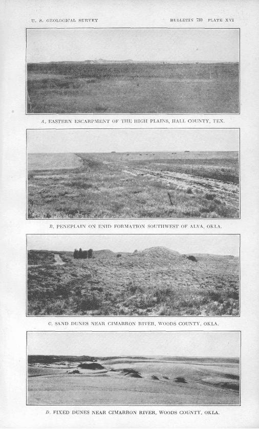
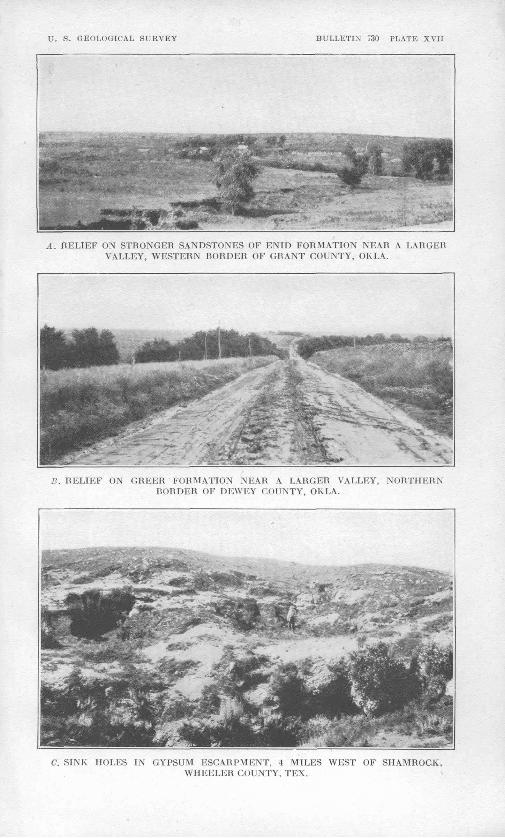
In Oklahoma the Enid formation is noteworthy for its great thickness 2 of shale and weak sandstone and a relative absence of escarpment-making beds. It therefore forms the substratum of a wide belt of very low relief in middle Oklahoma.3 (See PL XVI, B.) There are, however, minor escarpments or hilly belts (PI. XVII, A)
1 C. N. Gould (U. S. Geol. Survey Water-Supply Paper 148, p. 44, 1905) estimates tho thickness as 1,200 to 1,500 .feet.
3 George I. Adams (Physiographic divisions of Kansas : Am. Geog. Soc. Bull., vol. 34, p. 95, 1902) call? this the Oklahoma Prairie.
U. S. GEOLOGICAL SURVEY BULLETIN* 730 PLATE XVI
A. EASTERN ESCARPMENT OF THE HIGH PLAINS, IIAI.I, COUNTY, TEX.
P.. PENEPLAIN ON ENID FORMATION SOUTHWEST OF ALVA, OKLA.
C. SAND DUNES NEAR CIMARRON RIVER, WOODS COUNTY, OKLA.
Li. ¥\\KD DUNKS NEAR CIMARRON RIVER, WOODS COUNTY, OKLA.
PHYSIOGRAPHIC PROVINCES IN OKLAHOMA AND TEXAS. 121
within the area of outcrop of the Enid formation, especially on the east side. Farther south in Texas the rocks are less uniformly weak, the escarpments are more pronounced, and the peneplain is less perfect.
PENN&YLVANIAN SERIES.
The Pennsylvanian series farther east and the higher formations of the Permian series farther west include beds of more unequal resistance to erosion. In southeastern Kansas and northeastern Oklahoma the Pennsylvanian underlies the most typical portion of the Osage section of the Central Lowland. This portion consists of belts of peneplain trending east of north, separated by escarp ments, or narrow hilly belts, in each of which the general level rises westward by 50 to 200 feet. The whole region, therefore, resembles a stairway in which the risers are measured in feet and the treads in miles.
FORMATIONS ABOVE THE ENID FORMATION.
The surface on the higher Permian formations to the west is less smooth than that on the Enid formation. Aside from features due to aridity, it is more like that of northeastern Oklahoma. The general aspect is that of a peneplain, with the differences mentioned below. The plain is quite as perfect on the west side as on the east. Flat areas within sight of the Tertiary escarpment are as large and as flat as those near the Enid. (See PI. XVI, A and B.) Several escarpments are noteworthy.
Escarpment of Blaine formation. The Enid formation is over lain by the Blaine formation, which occupies the belt, next west of it in northern Oklahoma. The Blaine is 75 to 100 feet thick and is the most prominent gypsum-bearing formation in the State, and its outcrop belt, almost throughout its length, forms a pronounced escarpment known as the Gypsum Hills or " Gyp" Hills. This escarpment is in places deeply and sharply dissected, producing a belt of rugged country that ranges in width from a fraction of a mile near El Keno to 4 or 5 miles along Cimarron River in the north western counties of the State. When this escarpment is approached from the east in northern Oklahoma, it appears to be a well-marked physiographic boundary. Moreover, within a few miles west of it, at least in places, there is another marked escarpment. As the dis tance between the Blaine escarpment and the edge of the High Plains is here only 30 to 60 miles, as the rise across the strike is about 16 feet to the mile, and as the intervening belt is traversed by one major valley (North Fork of Canadian River) and contains abundant sand dunes, it will be seen that if this part of the State alone were considered, there would be some justification in regarding
122 CONTRIBUTIONS TO GEOGEAPHY OF UNITED STATES, 1922.
this line of the Gypsum Hills as the western limit of the Central Lowland.
The "break of the plains" here trends southwestward and the Blaine escarpment trends southeastward, so that, owing to this di vergence, only a short distance to the south the two are separated by an interval of more than 100 miles. The surface of the wide belt between them differs but slightly in character from that of the plain east of the Blaine escarpment, which, moreover, disappears north of El Reno, in latitude 35° 30', leaving the, so-called Plains Border without a natural boundary on the east for the remaining two-thirds of its length in Oklahoma and Texas.
Sandstone beds of the Woodward formation. The Permian for mations that underlie the surface west and south of the Blaine es carpment are fairly uniform in physical character, consisting mainly of red shale and sandstone. In their effect on topography they afford no contrast and offer no suggestions as to the division of the area into physiographic units. The most conspicuous escarpment maker in the Woodward formation is the Whitehorse sandstone member. In eastern Woodward County, several miles west of Quinlan and only 5 or 6 miles west ,of the Blaine escarpment, this sandstone forms a rugged escarpment more than 100 feet high, sharply dissected by young valleys, some of them 100 feet deep. This member is described 4 as forming conspicuous fcuttes and mesas 100 to 200 feet high from Kansas southward beyond Washita River to latitude 35°. These rugged, angular hills of intensely red sandstone give a striking char acter to the landscape and, so far as they go, would justify the recog nition of the area in which they occur as a distinct physiographic unit, but they are relatively isolated. The observer need only turn his back on them to see broad, flat, or gently rolling surfaces, indis tinguishable in topography and vegetation from the peneplain on the Enid formation. Not only do the buttes, mesas, and escarpments occupy a minute proportion of the total surface, but the area within which such features are in view is, by. comparison, insignificant.
In southern Kansas the Whitehorse sandstone member is an im portant element in the great escarpment which lies at the edge of the High Plains in their long eastward extension within the "big bend " of Arkansas Kiver. The dissection of that escarpment has made the Red Hills. At the south, in Oklahoma, this escarpment, together with that of the Blaine formation, turns northwestward along the Cimarron to make the narrow V whose sides face each other across that river. Farther south, toward Watonga, El Reno, and
4 Aurin, Fritz, Geology of the red beds of Oklahoma : Oklahoma Geol. Survey Bull. 30, p. 28, 1917. Most of the localities of buttes and mesas described by Aurin have been seen by the writer.
U. S. GEOLOGICAL SURVEY BULLETIN' 730 PLATE XVII
A. RELIEF ON STRONGER SANDSTONES OF ENID FORMATION NEAR A LARGER VALLEY, WESTERN RORDER OF GRANT COUNTY, OK LA.
RELIEF ON GHEUR FORMATION NEAR A LARGER VALLEY, NORTHERN BORDER OF DEWEY COUNTY, OKLA.
C. SINK HOLES IN GYPSUM ESCAIiPMENT, 4 MILES WEST OF SHAMROCK, WHEELER COUNTY, TEX.
PHYSIOGRAPHIC PROVINCES IN OKLAHOMA AND TEXAS. 123
Chickasha, the rugged aspect of the escarpment is less marked, but the sandstones of the Woodward formation tend to maintain a slight elevation above the surrounding country, as in Blaine County; or to give a more sharply rolling character to the divides, as between North Canadian and Canadian rivers west of El Reno; or to make high, bold bluffs now subject to revived erosion, as east and west of Anadarko.
Greer and Quartermaster formations. The topography on the Permian formations above the Whitehorse sandstone, as recognized by the Oklahoma Geological Survey,5 is for the most part rolling rather than flat (PI. XVII, #), but there are also broad areas of approximate flatness. So far as seen by the writer, such flat areas are more marked and extensive farther west in the "panhandle" of Texas.
" RED BEDS" OF UNCERTAIN RELATION.
The descriptions thus far given apply to that part of the area considered that lies north of the thirty-fifth parallel. On the Okla homa geologic maps a large area surrounding the Wichita Mountains appears as "Red Beds of uncertain relation." It might well be inferred that the reason for this uncertainty is to be found in the weakness of the rocks and a consequent lack of outcrops, the surface being therefore one of low relief. This inference as to topography agrees with the facts as described by Taff 6 and as observed in the reconnaissance by the writer. On the west side of the Salt Fork of Red River, which flows south in Harmon and Jackson counties, are some bluffs, mesas, and uplands that rise more than 200 feet above the stream. The escarpments contain prominent beds of gyp sum and sandstone. West of these escarpments the relief is less and the rolling surface merges into a broad peneplain. East of Salt Fork is the wide low plain that surrounds the Wichita Mountains and their outlying granite knobs. This plain east of the North Fork is coextensive with the area designated on the geologic maps of Oklahoma "Red Beds of uncertain relation." From 6 to 10 miles north of the Chicago, Rock Island & Pacific Railway this plain abuts on the north against a higher rolling surface marked on the geologic maps as occupied by the Greer formation. On its east side the plain in like manner ends against the long southeastward extension of the Greer formation, the surface of which is more strongly rolling.
If this locality alone were considered the line of contact shown on the geologic map might perhaps be used as a boundary for physio-
6 See map, Oklahoma Geol. Survey Bull. 11, p. 128, 1913.°Taff, .7. A., Preliminary report on the geology of the Arbuckle and Wichita mountains
in Indian Territory and Oklahoma: U. S. Geol. Survey Prof. Paper 31, pp. 72-74, 1904.
79153° 23 9
124 CONTRIBUTIONS TO GEOGRAPHY OF UNITED STATES, 1922.
graphic subdivisions, but the contrast in physiographic character is probabJy too small to justify divisions so important as sections. Moreover, as already mentioned, the sharp relief just west of this boundary is of very slight extent and is not representative of a broad area.
TEXAS PART OF AREA.
Escarpment of Permian rocks near Throckmorton. The Permian rocks change in character remarkably both northward and south ward from central Oklahoma. In both directions the red color dis appears and the thick beds of shale and generally weak sandstone give place to shale and limestone. Different sets of formations are recognized in Oklahoma and in Texas (see p. 120), and the correla tion of the two sets is not finally determined.
In Texas escarpments. appear along horizons not thus marked in Oklahoma. Some of them, if extended northward along the strike, would cross the low plains on the " Red Beds of uncertain relation " around the Wichita Mountains. Others would appear in the more strongly rolling surface to the east or to the west.
The easternmost of these escarpments in Texas seen by the writer lies a little west of the ninety-ninth meridian. (See fig. 43.) It trends slightly west of south and passes the villages of Throckmorton and Albany. In places it consists of several rather than a single es carpment, and it becomes higher and more ruggedly dissected toward the south, where its total height is 150 to 250 feet, but on the north it dies out in a wide sloping belt near Red River. The belt of dis sected escarpments near Throckmorton (the southernmost place reached on the trip) is at least 10 miles wide.
This series of escarpments is produced by resistant limestone beds in the upper part of the Wichita formation.7 East of it lies an " ir regular rolling surface of moderate relief," 8 the southward extension of the flattest part of the Osage section in Oklahoma. Farther east are the lower sandstone escarpments of the Pennsylvanian formations. Approached from the east the change in physiographic character at the rough limestone escarpment near Throckmorton is impressive, but this rugged belt can not well be used as a physiographic bound ary except for units of a smaller order than sections. In the first place, it dies out at the north in the midst of a wide plain; in the second place, it is succeeded on the west by plains 30 to 40 miles wide, broken only by intrenched streams that have begun anew to erode their valleys features which, though to a less extent, appear in the rolling plain east of the escarpment and are not uncommon in the
.'Gordon, C. H., Geology and underground waters of the Wichita region of north- central Texas: U. S. Geol. Survey Water-Supply Paper 317, p. 8, pi. 1, 1913.
8 Idem, p. 8.
PHYSIOGRAPHIC PROVINCES IN OKLAHOMA AND TEXAS. 125
flatter parts of central Oklahoma, even in the lowlands on the Enid formation.
Escarpments of Permian rocks near Aspermont. West of Throck- morton plains extend completely across Haskell County, a distance of 30 miles, and overlap into adjacent counties, where they abut against an 80-foot escarpment of gypsum and dolomite 6 miles east of Aspermont, in Stonewall County. This escarpment, with its com panion 7 miles farther west, is the local representative of the " Gyp sum Hills." It was not followed northward and southward, and data to show its exact correlation are not available. It may indicate the outcrop of the same beds that come to the surface at the western limit of the plains on the " Red Beds of uncertain relation " in Oklahoma. If so, there is here another line which might be used as a minor physiographic boundary. It is subject, however, to the same com ment as the others, namely, that the landscapes on its two sides show little or no contrast.
Seven miles west of this escarpment is another, of about the same height, made by beds of gypsum and sandstone. Between the two escarpments is a strip of nearly flat plain in which lies the town of Aspermont.
Peneplain in Texas part of the area. The top of the escarpment west of Aspermont affords a wide view of a peneplain which extends thence westward to the " break of the plains " that is, to the rela tively narrow strip of rough country which fringes the eastern edge of the Tertiary rocks. The distance across this peneplain is about 50 miles. The route followed leads northwestward to the towns of Spur and Dickens, in Dickens County.
The peneplain as observed in the first line of counties east of the High Plains (Kent, Dickens, Motley, Hall, Collingsworth, and Wheeler counties) compares favorably in its perfection .with that seen on any other part of the route traversed in the two States, except that the Enicl formation no doubt affords flat areas of greater extent, even if not flatter.
Here and there on this western part of the peneplain are buttes and mesas, much the most prominent of which is Double Mountain. Most of the others are close to the escarpments, of which they are outlying remnants. They impair the perfection of the peneplain much less than the intrenched streams. As stated above, these streams do not differentiate the area here considered from the Osage section, unless by the degree of their rejuvenation.
THE " BREAK OF THE PLAINS."
The escarpment at the eastern edge of the High Plains is gen erally clear, though not everywhere equally bold (PI. XVI, A).
126 CONTRIBUTIONS TO GEOGRAPHY OF UNITED STATES, 1922.
In only one of five counties in which it was approached or ascended in Texas does it fail to rise conspicuously on the western horizon. The exception is the northernmost county. Wheeler, in which it was approach at one place only. (See PL XVII, C.) At that place a rise of 500 feet is accomplished in about 10 miles west of the village of Shamrock, and throughout much of this distance sand dunes prevail. A semidetached eastward extension of the High Plains in Ellis County, Okla., north of Canadian River and the thirty-sixth parallel, shows a similar slope likewise dotted with sand dunes. Such grada tion with lack of a definite escarpment will probably be found to be general between the thirty-fifth and thirty-seventh parallels.
The escarpment at the edge of the Tertiary area is most prom inent where the Tertiary beds rest on resistant underlying rocks. In southern Kansas the escarpment is due to Cretaceous beds and Permian formations that have already been described. From the Kansas-Oklahoma boundary south to the thirty-fifth parallel, along the edge of the High Plains, Tertiary gravel rests on upper Permian formations, in which no strong escarpment-making members are known to the writer. It is not to be expected that this part of the High Plains boundary will be found to be as clear and distinct as other parts.
South of Red River the eastern edge of the High Plains coin cides essentially with the outcrop belt of the Triassic Dockum for mation and still farther* south with that of the Cretaceous lime stones. Udden 9 states that the " North-Central Plains " are bounded "on the west by the high erosion escarpment of the Pan Handle High Plains and the Llano Estacado," thus implying the presence of an eastward-facing escarpment throughout the length of the High Plains in this area.
SOME PRINCIPLES OP EROSION IN ARID CLIMATES.
Some physiographic features of this region can not well be described in terms suited to conceptions of erosion in more humid climates or on rocks of other character; therefore, as a preliminary to the physiographic history of the region, a brief description of these forms and the processes by which they were made will be given. It is convenient first to consider the effect of erosion as illustrated in the smaller forms, beginning with the gully, and to proceed thence to larger features and the larger questions involved.
Gullies in general. The physiographer's conception of the pro gressive dissection of peneplains, as of other plains, is based mainly on the growth of gullies. Rapid down cutting, steep sides, V-shaped cross section, and branching enter most abundantly into his mental
0 Udden, J. A., Review of the geology of Texas: Texas Univ. Bull. 44, p. 18, 1916.
U. S. GEOLOGICAL SURVEY BULLETIN 730 PLATE XVIII
A. I'HAIIUE DOG FORK OF RED RIVER, HALL COUNTY, TEX.
. ITH RECEDING ESCARPMENTS, GRAMT COUNTY, OKLA.
C. OLD VALLEY REJUVENATED, NORTH OF CHICKASHA, OKLA.
PHYSIOGRAPHIC PROVINCES IN OKLAHOMA AND TEXAS. 127
pictures of an upland of homogeneous material or horizontal rocks that is undergoing dissection, especially when erosion is vigorous.
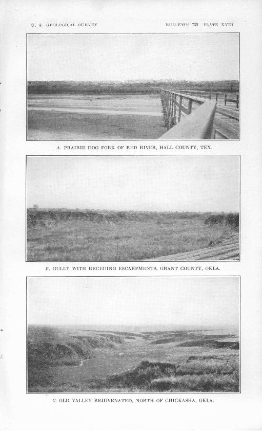
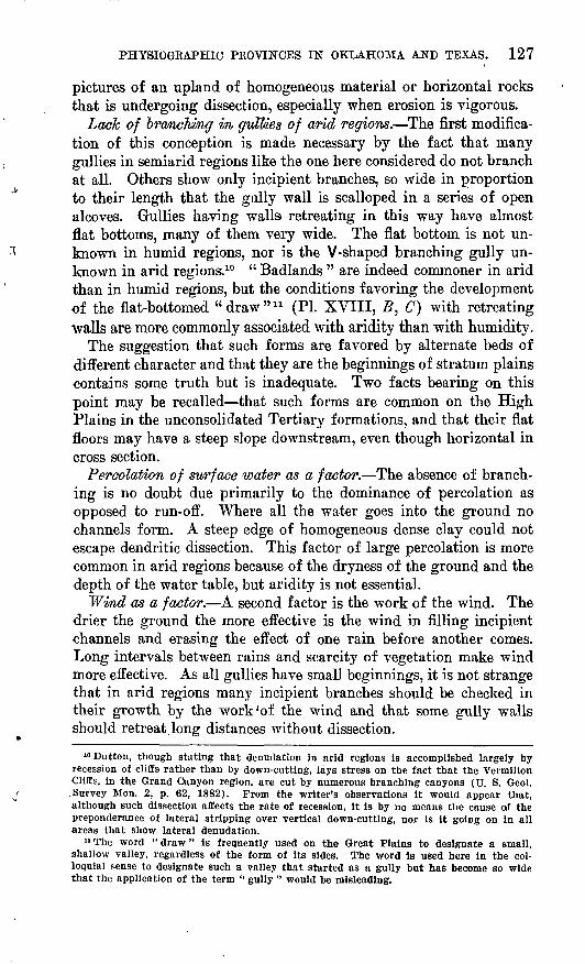
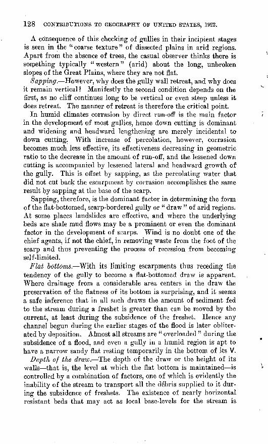
Lack of branching in guMes of arid regions. The first modifica tion of this conception is made necessary by the fact that many gullies in semiarid regions like the one here considered do not branch at all. Others show only incipient branches, so wide in proportion to their length that the gully wall is scalloped in a series of open alcoves. Gullies having walls retreating in this way have almost flat bottoms, many of them very wide. The flat bottom is not un known in humid regions, nor is the V-shaped branching gully un known in arid regions.10 " Badlands " are indeed commoner in arid than in humid regions, but the conditions favoring the development of the flat-bottomed "draw" 11 (PL XVIII, B, C) with retreating walls are more commonly associated with aridity than with humidity.
The suggestion that such forms are favored by alternate beds of different character and that they are the beginnings of stratum plains contains some truth but is inadequate. Two facts bearing on this point may be recalled that such forms are common on the High Plains in the unconsolidated Tertiary formations, and that their flat floors may have a steep slope downstream, even though horizontal in cross section.
Percolation of surface water as a factor. The absence of branch ing is no doubt due primarily to the dominance of percolation as opposed to run-off. Where all the water goes into the ground no channels form. A steep edge of homogeneous dense clay could not escape dendritic dissection. This factor of large percolation is more common in arid regions because of the dryness of the ground and the depth of the water table, but aridity is not essential.
Wind as a factor. A second factor is the work of the wind. The drier the ground the more effective is the wind in filling incipient channels and erasing the effect of one rain before another comes. Long intervals between rains and scarcity of vegetation make wind more effective. As all gullies have small beginnings, it is not strange that in arid regions many incipient branches should be checked in their growth by the work'of the wind and that some gully walls should retreat long distances without dissection.
10 Button, though stating that denudation in arid regions is accomplished largely by recession of cliffs rather than by down-cutting, lays stress on the fact that the Vermilion liffs, in the Grand Canyon region, are cut by numerous branching canyons (U. S. Geol. .Survey Mon. 2, p. 62, 1882). From the writer's observations it would appear that, although such dissection affects the rate of recession, it is by no means the cause of the preponderance of lateral stripping over vertical down-cutting, nor is it going on in all areas that show lateral denudation.
11 The word " draw " is frequently used on the Great Plains to designate a small, shallow valley, regardless of the form of its sides. The word is used here in the col loquial sense to designate such a valley that started as a gully but has become so wide that the application of the term " gully " would be misleading.
128 CONTRIBUTIONS TO GEOGRAPHY OF UNITED STATES, 1922.
A consequence of this checking of gullies in their incipient stages is seen in the "coarse texture" of dissected plains in arid regions. Apart from the absence of trees, the casual observer thinks there is something typically "western" (arid) about the long, unbroken slopes of the Great Plains, where they are not flat.
Sapping. However, why does the gully wall retreat, and why does it remain vertical? Manifestly the second condition depends on the first, as no cliff continues long to be vertical or even steep unless it does retreat. The manner of retreat is therefore the critical point.
In humid climates corrasion by direct run-off is the main factor in the development of most gullies, hence down cutting is dominant and widening and headward lengthening are merely incidental to down cutting. With increase of percolation, however, corrasion becomes much, less effective, its effectiveness decreasing in geometric ratio to the decrease in the amount of run-off, and the lessened down cutting is accompanied by lessened lateral and headward growth of the gully. This is offset by sapping, as the percolating water that did not cut back the escarpment by corrasion accomplishes the same result by sapping at the base of the scarp.
Sapping, therefore, is the dominant factor in determining the form of the flat-bottomed, scarp-bordered gully or " draw " of arid regions. At some places landslides are effective, and where the underlying beds are shale mud flows may be a prominent or even the dominant factor in the development of scarps. Wind is no doubt one of the chief agents, if not the chief, in removing waste from the foot of the scarp and thus preventing the process of recession from becoming self-limited.
Flat bottoms. With its limiting escarpments thus receding the tendency of the gully to become a flat-bottomed draw is apparent. Where drainage from a considerable area centers in the draw the preservation of the flatness of its bottom is surprising, and it seems a safe inference that in all such draws the amount of sediment fed to the stream during a freshet is greater than can be moved by the current, at least during the subsidence of the freshet. Hence any channel begun during the earlier stages of the flood is later obliter ated by deposition. Almost all streams are " overloaded " during the subsidence of a flood, and even a gully in a humid region is apt to have a narrow sandy flat resting temporarily in the bottom of its V.
Depth of the draw. The depth of the draw or the height of its walls that is, the level at which the flat bottom is maintained is controlled by a combination of factors, one of which is evidently the inability of the stream to transport all the debris supplied to it dur ing the subsidence of freshets. The existence of nearly horizontal resistant beds that may act as local base-levels for the stream is
PHYSIOGRAPHIC PROVINCES IN OKLAHOMA AND TEXAS. 129
another, and less obvious factors are the depth of the water table and the state of the soil above the water table, especially with respect to its content of moisture and salts. It can not be assumed that the base of the escarpment is generally as low as the water table or that ground water issues along it in springs, as other factors help to locate the horizon of effective sapping. Arid soils contain abundant salts, which cement and indurate the soils more at some levels than at others, and they tend to concentrate in the upper soil and to accumu late and form " mortar beds " near the water table. Unequal vertical distribution of this cementation may be an important factor in de termining the horizon of sapping in an otherwise homogeneous for mation.
Terraced draws. It is not uncommon to find a new gully furrow ing the floor of a wide, flat-bottomed draw. At first sight this might be interpreted as indicating a new cycle of erosion. It should be remembered, however, that conditions of the same sort as those which preserved the original surface from dendritic dissection, though in an exposed position and above its local base-level, may for a long time preserve the new flat at the bottom of the draw. When, with the development of the valley, the time comes to cut the bed of the stream down to a new level, the same process may be repeated, and thus flat after flat may be formed more or less rhythmically without any change in the regional base-level. No doubt, also, minor or temporary climatic changes or changes in vegetation cause many newly made valleys to be aggraded and degraded again within short periods.
Larger valleys. The discussion has thus far concerned itself with gullies and draws because the mechanics of growth and change are clearer in those than in large valleys, but the same principles evi dently control the development of all. The same factors must also control the extensive stripping of stratum plains.
Near Ferguson, in Blaine County, Okla., the peneplain on the Enid formation is exceptionally well developed. In the midst of this nearly flat plain the headwaters of Salt Creek flow in a flat-bottomed valley 40 feet deep and a considerable fraction of a mile wide. The edge of this valley, where crossed-during the reconnaissance, is an abrupt escarpment marked by a very narrow strip of badlands but is straight for long distances and unbroken by any ravines within sight. If the escarpment is left out of view, here are two flat plains at different levels, one as flat as the other. A few hundred feet back from the top of the escarpment the peneplain is not being worn down by streams. At 200 feet out from its foot the lower plain is perfect. This lower plain is not a flood plain, nor is the escarpment an.ordi nary stream bluff. The stream has had nothing to do with making
130 CONTRIBUTIONS TO GEOGRAPHY OF UNITED STATES, 1922.
either feature except to lower the local base-level. It would appear that the gradient of Salt Creek is very moderate for so small a stream. The surface is simply being stripped horizontally. The rock is fine argillaceous red sandstone or sandy shale. There is no reason to think that an alternation of resistant and weak beds is a significant factor. This is one of many striking illustrations of the tendency toward rapid lateral stripping with little or no evidence of wearing down. Examples were found throughout the outcrop of the Permian "Red Beds," though few exhibit such vigorous escarpment cutting. The two significant and remarkable things about Salt Creek are that a plain only 40 feet above its local base-level should be attacked so vigorously and that there should be such a lack of dendritic dissec tion.
An extreme illustration of the same process is found in the valley of the South Fork of Wichita River in Knox County, Tex., a few miles north of Benjamin. Here the river has cut a trench 8 miles wide in one of the flattest plains in the region. The walls of the trench are between 100 and 150 feet high, and the floor is almost flat. Small residual masses stand upon it, but the relief is in few places more than 10 feet and is of such a character as to show that the stream has never meandered over more than an insignificant fraction of the valley floor. The one thing that the stream has done is to lower the local base-level. The rest of the trench cutting was done by lateral stripping. The limiting walls, though notched in a small way, are surprisingly straight, and no tendency to den dritic dissection was seen in the adjacent flat upland.
Stratwm plains. The mention of " stripping " at once suggests the denudation of certain resistant beds and the production of stratum plains, which need not be at the local base-level. In the valleys thus far mentioned no positive evidence was seen that the levels of the new and lower plains (the valley floors) were thus determined. The topographic results may suggest resistant beds beneath the valley floors, but it should be remembered that similar stripping is observed in gullies and draws where the control of resistant beds can not be assumed, and that the general appearance of these larger valleys suggests that the streams are at their local base-levels, thus making unnecessary the hypothesis of resistant beds.
Advancing once more in the scale of size, we come to the broad plains which lie between the major eastward-facing escarpments. Here there is definite evidence in the escarpments themselves that the relative resistance to erosion of the beds has been an important factor in fixing the levels of the several plains, at least near their eastern edges. To some extent, at least, these plains conform in origin to the customary conception of a stratum plain.
PHYSIOGRAPHIC PROVINCES IN OKLAHOMA AND TEXAS. 131
Special conditions of valley cutting in scarped plains. Another theoretical problem concerns the conditions of peneplanation and valley cutting peculiar to scarped plains (p. 116). The. redevelopment of escarpments in a second cycle implies that certain more resistant beds have been able, at least in part, to maintain temporary base- levels for stream basins above the escarpments. It is conceivable that peneplains may be developed on the intervening weak beds before the master streams flowing over the strong beds have cut down their profiles completely to the new base-level. Further lower ing of the stream's bed across the hard rocks must then be accom panied by a corresponding down cutting within the limits of the intervening peneplains. The rate of such down cutting may be so slow that the local peneplains are. lowered concurrently. On the other hand, values may be assigned to tine several factors involved (resistance of escarpment rock and of overlying beds, power of streams, area of basins, etc.) which make it possible for the streams to cut shallow valleys in the peneplains. The factors have not been evaluated in this area, but many of the streams, especially in the western part, occupy wide valleys of gentle slope, trenched by narrow valleys'between steep bluffs. It seems probable that these wide val leys are due to the conditions here described, which attend the wearing down of scarped plains and do not indicate a distinct uplift of the region, as does, presumably, the more recent and abrupt intrenchment.
Aggrading streams. It is frequently assumed that the character istic features of the stream channels of this region indicate aggrada tion that is, the progressive filling of the valleys with alluvium. The features referred to are the exceedingly wide, flat channels show ing at low water numerous sand bars among which the stream flows in " braided " fashion so long as any water remains in the channels (PI. XVIII, A). Without doubt such features are characteristic of "overloaded" streams. There can be no question that when the features.visible at low water were formed the stream was supplied with more load than it could transport and was depositing more than it was removing. On the other hand, the major features of many of the valleys give no support to the assumption of progressive aggra dation. They may even indicate the opposite. Terracing is common in the larger valleys. On the Prairie Dog Fork of Red River the 80-foot terrace seen in the background in Plate XVIII, A, consists of laminated alluvium, the upper 40 feet of which stands with a vertical face a few hundred yards from the river. Necessarily such a terrace is a short-lived feature, and it can not have been very long since the stream cut down to its present level and exposed its earlier alluvium to erosion. Yet no stream could be found which presents in a more typical form the features commonly interpreted as indi cating aggradation.
132 CONTRIBUTIONS TO GEOGRAPHY OF UNITED STATES, 1922./
The building of a sand bar is of course a more recent process than the cutting of a terrace, and it is not impossible that recent down cutting has given way to still more recent filling. Nothing is yet known, however, to invalidate the assumption that the aggradation noted is simply that which is incidental to the subsiding stages of every flood, and that during the rising stages of the floods more material is carried away than is deposited during the subsiding stages. The process of removal is of course not subject to direct observation, nor are its results except as seen in the larger features of the valley. The features due to periodic deposition are the ones that most appeal to the eye during 99 per cent of the time.
It follows from this that a so-called "overloaded" stream is not necessarily an aggrading stream in the sense that implies pro gressive or cumulative aggradation, but one which is supplied with a very large volume of detritus, some of which moves forward with each flood. Between such times the excess of load is stowed away, a part of it in sand bars but much the greater part of it in the thick sheet of sand and gravel that rests on the bedrock under the bed of the stream. If this sheet is so thick that the scour during floods fails to reach the rock beneath, then deposition has been cumulative and the stream has been aggrading, for the level of the bedrock surface is due to erosion. P
As the possible depth of scour by such streams is not known, it can not be positively asserted that the scour always reaches the bed rock. The very few data obtained on the thickness of sand and gravel under channels seem to indicate that it is proportional to the size of the stream, and that this sheet of material, though thicker than would be casually assumed to be subject to scour, is not thick enough to warrant the positive conclusion that it is not subject to such removal. Depths to rock beneath the larger streams in this area seem to be fairly uniform from 30 to 40 feet, or very little more. Under these circumstances much importance should be attached to the general features of the valley, as suggested above.
The additional fact that active gullying is in progress near the larger streams adds to the evidence that these streams are, on the whole, degrading their channels instead of aggrading. Too much weight should not be given to the evidence of gullies, however, in view of their intimate connection with vegetation, cultivation, graz ing, etc. The distribution of active gullying has not been sufficintly studied to determine what the influence of these factors may be.
SUMMARY OF PHYSIOGRAPHIC FEATURES ANDHISTORY.
Relief. The region is in general one of slight relief, less than 100 feet in a mile on the average, and features showing relief of 200 feet
PHYSIOGRAPHIC PROVINCES IN" OKLAHOMA AND TEXAS. 133
are exceptional. Large areas are so nearly flat that the slopes should be called faint rather than gentle. The coarse-textured drainage pattern is an additional characteristic of a peneplain.
The more striking features of the relief are eastward-facing escarp ments and intrenched valleys. In the southwestern part of the region steep-sided mesas are also noteworthy.
Streams. The region from Arkansas River on the north to Brazos River on the south is crossed by a number of remarkably parallel streams. Probably nowhere else in the United States do so many main streams run so near together for such long distances. Most of these streams are intrenched in relatively narrow valleys. They are characteristically but not universally attended, especially on their northeast banks, by belts of sand dunes from 2 to 10 miles or more wide (PI. XVI, tf, D).
Indications of more than one cycle of erosion-. Indications of at least two cycles of erosion are widespread, and an additional re juvenation has also occurred in many places. The features sug gesting two or more cycles are the intrenchment of all the larger valleys and many of the smaller ones and active gullying near some intrenched streams. All the main streams of the region were crossed in this investigation, most of them at more than one place. The Arkansas, Salt Fork of the Arkansas, Cimarron, North Canadian, Canadian, Washita, and the several forks of Red River ancT of the Wichita and Brazos are all intrenched below the peneplain level. Generally they are bordered by bluffs, more or less steep, the full height of which ranges from 50 to 200 feet. Where bluffs are lack ing their place may be taken by long slopes. At many places, espe cially in the western part of the area, both bluffs and long slopes may be seen, the slopes rising for a mile or more from the top of the bluffs to the level of the upland. This is seen on most of the upper branches of the Red, Wichita, and Brazos. A revival of cutting power is, of course, indicated by the bluffs. Whether the
*old valleys indicated by the gentle slopes belong to the cycle of peneplanation or to a later cycle remains undetermined by any field study yet made. Considerations mentioned above under " Special conditions of valley cutting in scarped plains" show that these slopes do not necessarily indicate revival of crustal uplift.
From the study made in the field it was not possible to correlate peneplains for long distances. The two cycles observed at one place may or may not correspond to the two cycles observed elsewhere.
Hypotheses respecting former 'base-leveling. To what extent the entire area should be conceived of as having been peneplaned in the commonly accepted sense of that term (reduced nearly to base-level) is uncertain. If the entire area ever was a single peneplain, the present escarpments must have been produced by revival, and the
134 CONTRIBUTIONS TO GEOGRAPHY OP UNITED STATES, 1922.
several plain belts between them are either peneplains or stripped plains of a newer cycle.
Over against this conclusion may be set the hypothesis that the area was never one general peneplain and that the existing escarpments have been present, though retreating westward, throughout the proc ess of denudation. It may be that in the general down cutting each escarpment-making member has determined a local base-level and that the plains west of it to the next escarpment were kept cut down to the local base-level by the ordinary processes of stream and inter- stream erosion. Again, it may be that these familiar processes were always subordinate, and that progressive lowering has been accom plished mainly by the westward recession of escarpments. The general straightness of the escarpments and, in a large way, the levelness of their tops favor the assumption of general peneplanation.
The remarkable parallelism of the streams requires the assumption of a very flat plain on which they originated. This may have been either a peneplain or the former eastward extension of the Tertiary mantle of the High Plains.
It seems probable, therefore, that there occurred in this region (1) the formation of a general peneplain, (2) one or more uplifts, and (3) the development of the present escarpments and intervening plains Jby renewed erosion in which lateral stripping as described above was prominent and perhaps dominant. This process would account for the typical steep-sided mesas found especially in the Texas part of the region. It would also explain the juxtaposition of other plains at diverse levels, which would otherwise require the assumption of distinct uplifts and partly completed cycles.
It is probably best to speak of these plains as peneplains rather than stratum plains. In any case they were developed by a combi nation of processes and probably at their local base-levels. Through out much of the larger part of the area they now have the character istic topography of what is commonly called a peneplain.
A.Page.
Acknowledgments for aid_____ 20,104Adobe flats, description of_____ 69-70
dunes on_ ________ 71Afton Junction, Iowa, glacial pebbles
from, plates showing- 95Aggradation, appearance of, by
streams, in arid re gions __________ 131-132
AJo Mountains, Ariz., plates show ing____________ 42
Albuquerque, N. Mex., former growth' of hay near________. 80
Alinement charts, use of_______ 96Alluvium in the Papago country,
Ariz___________ 28-32Altar Valley, Ariz., terraces in_ _ 73-74Alva, Okla., peneplain southwest of,
plate showing __ 120Andrews Glacier, Colo., location of_ 13
plate showing ______ _ 9Aridity, influence of, on erosion and
sedimentation_____ 37-38Arivaca Creek, Ariz., terrace on 74Aspermont, Tex., escarpments of
Permian rocks near 125
B.
Baboquivari Mountains, Ariz., drain age course from, to So- noita River______ 67-68
Barajita Valley, Ariz., drainage course from, to Gila River ______ 68
terraces in _ _ 81Basins, headwater, formation of 48" Benches, suballuvial." See Pedi
ments.Black Canyon, Colo., features of_ 12,13-14
plate showing 12Blaine formation, escarpment formed
by, in Oklahoma___ 121-122Boulders, detachment of, on moun
tain slopes _______ 39,43-46" Break of the plains," direction of,
near the Gypsum Hills, Okla________ _ 122
form and. position of_ 116. prominence of escarpment .at,
in Texas _______ 125-126
C.
Cabeza Prleta Mountains, Ariz., lava-capped mountain in__________________
Canyon cycle, effects of erosionduring _ ___ 5,
Canyons, cutting of_______ Central City quadrangle, Colo., map
and profile section of part of__ ___
Central Lowland, location and alti tude of_________
Charco, use of term_____________Chasm, The, on Longs Peak, Colo.,
origin of ____ _plate showing. _________
Chemical action in rocks, effects of- Cirques, features of__________
plates showing_______________Comanche Peak, Colo., cirque near,
features of___-_cirque near, plate showing __
Conglomerate, niches formed ia___Continental Divide in Colorado_____Convexity gage, plate showing. __Copcland Lake, Colo., moraine south
of, origin of--- __-moraine south of, plate showing
Corrosion, action of ________ 46,Curvature of pebbles, measurement
of ___ _________Cycles of erosion, two recognized in
Colorado _ _______
D.
Detritus, deposition of, by streams_ Developed edge, use of term_______Disintegration, granular, of rocks,
cause of______ Dissection of mountains, cause of_ Double Mountain, Tex., location of__ Draw, use of term________________
Page.
13-14 46-48
13 10
4.1-4210,13
10
10,1310
50,517
04
11,1311
47,48
93,96
1-2
2893
4111
125127
Draws, cutting of terraces in 129 factors controlling depth of 128-129 preservation of flat bottoms of,
in arid regions-_____ 128 Dunes, in the Papago country, Ariz.,
occurrence of 70 71 near Cimarron River, Woods
County, Okla., plates showing 120
135
136 INDEX.
E.Page.
Enld formation, features of, in Okla homa_________ 120-121
Erosion, canyon cycle of__ _ 16 17 chemical processes of_____ 41-42 early, in the Rocky Mountains,
in Colorado _ 14 mechanical processes of - 39-41
in arid climates_____ 126-132 third cycle of__________ 2-3,14 two cycles of, recognized in the
Rocky Mountains, in Colorado ________ 1-2
Escarpments, receding, on gully,plate showing______ 122
Estes Park, Colo., origin of 7,14 plate showing___________ 7
Exfoliation of rocks, features of_ 40-41
F.
Faulting in the .Papago country,Ariz ____________ 33-36
Felsite, erosion of_________ 46Fillman, L., determination of round-
ness of limestone peb bles by________ 113-114
Flatness ratio, formula for____ 93 Flats, adobe, description of 69-70
adobe, wind deposits on ___ 71 Flattop Mountain, Colo., plate show
ing _ 6 view northwest from, plate
showing ________ 6 Flattop peneplain, in Colorado, cor
relation of_;__-___ 14 formation of________ 15 modification of, by glaciers_ 13 remnants of ____________ 3, 4
plates showing__ _ 6, 7, 10 Flood, sheet, description of_____ 68-69 Florissant, Colo., origin of gravel
beds near_ _ 1C Fos'sils, occurrence of, in the Papago
country, Ariz__ 22,23,24,31 Fragments, separation of, from
rocks__________ 92 Front Range, Colo., profile across,
showing relation of Flattop peneplain to Rocky Mountain pene plain______ ___ 5
G.
Georgetown, Colo., quadrangle, pene plain recognized in_ 1-2
Gidley, J. W., fossils determined by_ 31, 32 <3ila River, drainage course to, from
Barajita Valley ____ 68 terraces on ______ 30-32, 71-73
Girty, G. H., fossils determined by 22,23 Glaciation, pre-Wisconsin, apparent
results of ___--__ 12,13 Wisconsin, results of 13
Glossary of physiographic terms 86-90
Pago.Gneiss, closely jointed, erosion of_ 46 Granite, erosion of, on mountain
slopes _ _ _ 45-46 niches formed in'-- ___ 49-50
-Gravel beds near Florissant, Colo.,origin of __ 16
Great Plain's, location and altitudeof____________- .115
Greer formation, topography on, inOklahoma and Texas- 12",
Gregory, H. E., on the discrimina tion of classes of peb bles__________ 91
Growler Mountains, Ariz., faults in_ 30 from the west, plate showing 43
Gullies, branching of, influences af fecting________ 126-127
in arid regions, features of 127 in humid regions, features of_ 126-127 on mountain slopes, formation
and filling of__ 43-44 See also Draws.
H.
Hagues Peak, glacier on, naming of- 13glacier on, plate showing 7
Hallett Glacier, Colo., features of__ 13plate showing 7
Hallett Peak, Colo., plates showing- 6, 7Headwater basin in the Sand Tank
Mountains, Ariz_ 61 High Plains section of the Great
Plains, eastern escarp ment of, in Texas, plate showing_____ 120
origin and features of_ 115-116
I.
Igneous rocks, accumulation ofde'bris from_____ 15
Inscription painted on rock, per sistence of____ 49-50
J.
Jackson Butte, Ariz., basalt of__ 27
K.
Kino, Father, description of SantaCruz Valley by____ 78, 79
Kirk, Edwin, fossils determined by_ 23
L.
Landslides, erosion by, in aridregions _________ 128
Lava, cliffy slopes of, on the Ajo Mountains, Ariz., plates showing____ 42
mountain capped with, in the Cabeza Prieta Moun tains, plate showing_ 43
Lavas, bedded, erosion of___ _ 43 See also Volcanic rocks.
INDEX. 137
Page.Little Ajo Mountains, Ariz., prob
able Mesozoic igneous rocks in__ _ ___ .25
Longs Peak, Colo., plates showing- 6,12 , The Chasm on, origin of____ 13
plate showing. _ ___ 10 timber-line tree on, plate show
ing____________ 11
M.
McGee, W. J., cited--____ Maricopa Mountains, Ariz., east
slope of, plate show ing ,______
felsite of outlier east of_ _Measurement of pebbles, method of-Medicine Bow Mountains, plate
showing_____________Mesozoic rocks in the Papago coun
try, Am____________Mills moraine, Colo., features of_
plate showing_______________Monaclnocks, examples of, on the
Flattop peneplain in Colorado____________
Moraine Park, Colo., moraine south of, origin of__ __
moraine south of, plate show ing _ _____
Mountain slopes, angles of, in the Papago country, Ariz_
angles of, influences control ling________________
boulder-controlled, production and persistence of__
cliffy, production and persist- once of_____________
conditions determining _______grades* of___________________plate showing. ___ :. rain-washed, erosion of_______
Mud flows, development of scarps by, in arid regions_
Gl27-28 93-96
6
24_269,18
9
15
13
7
38,42
42-46
43-46
1 4238-3938,42
6046
128
N.
Needles, The, Colo., plates showing- '7,12 Niches, formation of_________ 49-51 Nogales Wash, Ariz., course of__ '74
valley of______-_-____ 75 Nomographic charts, use of-____ 96
0.
Oklahoma, western, physiographic features and history of-__________ 132-134
Osage section of the Central Low land, features of___ 116-117
P.
55Paige, Siciney, cited _____ ____.Paleozoic rocks in the Papago coun
try, Ariz., nature and age of-________ 22-24
Page.Papago country, Ariz., character of
the mountains in 36-37 former moist climate in____ 78-80 geography of___________ 19-20 geologic history of-______ 81-85geology of _________ 20-37 reconnaissance geologic map
of _ In pocket, stratigraphy of__________ 20-33 structure of____________ 33-37 Tertiary events in ____ S2-S3 Tertiary rocks in__________ 26-28
Patagonia Mountains, Ariz., Co-manche rocks in____ 24
Mesozoic igneous rocks in____ 25 Pebbles, field work on, method of- 106-100
glacial, from Afton Junction,Iowa, plates showing.- 95
glacial and sand-blasted, be fore and after artificial abrasion, plates show ing___________ »4
measurements of, plotting of- 97-102 original shapes of-_ 92-93 relation of roundnesa of, to size
and to distance of transportation ___ 108-111
Pediments, dissected, plates show- ing __ _______ 60, 61/
mountain, burying of__-___ 58-60 coalescence of _ ___ 60 dissection of_______ 53,60-65 formation of_______ 48, 54-58 nature of_ __ _____ 52-54
Peneplain cast of the High Plainsin Texas, features of_ 125
Peneplain southwest of Alva, Okla.,plate showing_____ 120
Pennsylvaniau series, surface upon, in southeastern Kansas and northeastern Okla homa __________ 121
Percolation of surface water, in fluence of, on the branching of gullies_ 127
Permian rocks, escarpment of, nearThrockmorton, Tex_ 124-125
escarpments of, near Asper-mout,'Tex_______ 125
Phyllite, erosion of_-_______-__' 40 ,Pikes Peak, Colo., plateau near,
features of_______ 2Pillars, formation of_________ 51-52" Plains Border,'* conclusions on__ US
field work in__________ 119-120formations recognized in____ 120problem .of _______-___ 117-118
Plains, scarped, cutting of valleysin_____________ 13.1.
stratum, origin of_________ 130 " Platforms, subaerial." Sec Pedi
ments.Playas, occurrence of_________ 70 Potrero Creek, Ariz., course of___ 74
138 INDEX.
Page. Prairie Dog Fork of Red River, Hall
County, Tex., plateshowing_________ 122
Pre-Cambrian basal complex in thePapago country, Ariz_22-22
Prospect Mountain, view from, plateshowing_________ 7
Q.
Quartermaster formation, topogra phy on. in Oklahoma and Texas_______ 123
Quaternary deposits in the Papagocountry, Ariz______ 28-33
R.
Recession of mountain slopes, proc ess causing__ ___ 42-46
" Red Beds" hogback, plate show ing 8
"Red Beds" of uncertain relation, topography .on, in Oklahoma_______ 123-124
Relief on Enid formation in Grant County, Okla., plate showing_________ 122
Relief on Greer formation in Dewey County, Okla., plate showing _____ 122
Rigor, use of term 110Rio Puerco, N. Mex., cutting of chan
nel of__________ 80Rivers. See Streams.Rock shelters, formation of 50Rock spalls. See Boulders.Rocky Mountain peneplain, evidence
of_____________ 5, 14. features of_____________ 2 formation of____________ 15-16 modification of, by glaciers__ 13 remnants of, plates showing_ 7,12
Rocky Mountains, profile across, through Longs Peak, events indicated by 3
uplift of__________ ___ 14Roundness ratio, formula for_ 93Rupture of rocks, cause of___ 40Russell Fork of Big Sandy River,
Va., course of_____ 105 quartzite on __________ 105-106
S. Sacaton Mountains, Ariz., Mesozoic
igneous rocks in _ 25 Sand Tank Mountains, Ariz., faults
in ____ ________ 34-35 headwater basin and dissected
pediment in, plate showing. ___ 61
Santa Cruz River, Ariz., course andtributaries of ______ 74-75
terraces along 75-78 Santa Rita Mountains, Ariz., Co-
manche rocks in__ 24 Mesozoic igneous rocks in 25
Page.Santan Mountains, Ariz., volcanic
rocks of_ 27Sapping, erosion by, in arid regions. 128Scale, circular logorithmic, descrip
tion of__________ 96Schist, erosion of____________ 46Shapes of pebbles, original __ 92-93Sierra del Plnacate, Ariz., lava flow
from __________ 33Sierra Estrella, Ariz., Mesozoic igne
ous rocks in _ _ 25Sierra type of mountain, process of
carving _________ 47-48Sink holes west of Shamrock, Tex.,
plate showing_____ 122Slopes of mountains. See Mountain
slopes.Sonoita Creek, Ariz., course of___ 74Sonoita River, Ariz., cutting of chan
nel of___________ 79 drainage course to, from Babo-
quivari River_____ 67-68Sprague Glacier, Colo., location of_ 13
plate showing_ ________ 6Stanton, T. W., fossils determined by 24Stream, graded, use of term____ 47Streams, appearance of aggradation
hy, in arid regions__ 131-132 axial, in arid valleys______ 67-68 tributary, in arid valleys____ 68-69 parallel, in Oklahoma and
Texas_______,___ 133Striae, removal of, from pebbles by
abrasion_______ _ 114Stripping of valleys and stratum
plains_________ 129-130Stylus for use with nomographic
chart, construction of_ 96
T.
Tahosa Valley, Colo., features of_ 12,14 plate showing _ _ 12
Talus, formation and removal of 43-46 Taylor Glacier, Colo., location of_ 13 Temperature of rocks, changes in _ 39 41 Terraces, formation of, in the Pa
pago country, Ariz 71-81 Texas, northern, physiographic fea
tures and history of- 132-134 Thompson River canyon, Colo., plates
showing 7, 8 Throckmorton, Tex., escarpment
near __________ 124-125 Tucson, Ariz., former conditions
near _____ _ 78 Santa Cruz Valley near___ 77, 78
Tucson Mountains, Ariz., volcanicrocks of__ 27
Tuff, erosion of___________ _ 43, 46Tule Mountains, Ariz., faults in___ 35-36 Tule Tank, Ariz., pass west of 6Q Tumacacori Mountains, Ariz., Meso
zoic rocks in 24 Tumamoc Hills, Ariz., volcanic rocks
of_____________ 2T
INDEX. 139
Page.Tumbling barrel for abrasion of peb
bles, plates showing 95 use of _____________ 110
Tyndall Glacier, Colo., gorge below,features, of______ 8,13
gorge below, plate showing-. 8 location of _______ __ 13 plate showing___________ 8
V.
Valley, rejuvenated, plate showing 126Valleys, changes taking place in__ 66
drainage of_____4.______ 66-69origin of _____________- 65-66stripping of, in arid regions-- 129-130
Vekol Valley, Ariz., terraces andstream channels in 80-81
79153° 23 10
Page.Volcanic rocks, distribution of, in
the Papago country, Ariz____________ 26-28
W.
Weathering, action of temperaturein_____________ 39-41
Whitehorse sandstone member, topo graphic features formed by, in Oklahoma__ 122-123
Wind, action of, on trees and snow_ 11 deposits made by, in the Papago
country, Ariz__ 70-71 influence of, in checking gully
ing__________ 127-128Woodward formation, topographic
features on, in Okla homa-________ 122-123
o