Embed Size (px)
Citation preview

Physiographic Studies in Southern PennsylvaniaAuthor(s): George W. StoseSource: The Journal of Geology, Vol. 12, No. 6 (Sep. - Oct., 1904), pp. 473-484Published by: The University of Chicago PressStable URL: http://www.jstor.org/stable/30056545 .
Accessed: 16/05/2014 12:04
Your use of the JSTOR archive indicates your acceptance of the Terms & Conditions of Use, available at .http://www.jstor.org/page/info/about/policies/terms.jsp
.JSTOR is a not-for-profit service that helps scholars, researchers, and students discover, use, and build upon a wide range ofcontent in a trusted digital archive. We use information technology and tools to increase productivity and facilitate new formsof scholarship. For more information about JSTOR, please contact [email protected].
.
The University of Chicago Press is collaborating with JSTOR to digitize, preserve and extend access to TheJournal of Geology.
http://www.jstor.org
This content downloaded from 194.29.185.71 on Fri, 16 May 2014 12:04:27 PMAll use subject to JSTOR Terms and Conditions

THE
JOURNAL OF GEOLOGY
SEPTEMBER-OCTOBER, 1904
PHYSIOGRAPHIC STUDIES IN SOUTHERN
PENNSYLVANIA.' CUMBERLAND VALLEY is the northward extension into Maryland
and Pennsylvania of the Shenandoah Valley of Virginia. It is a broad limestone valley, with low, shale hills, lying between South Mountain on the east, and Tuscarora Mountain and associated
ridges on the west. The southern portion is drained chiefly by Conococheague and Antietam creeks into the Potomac, and the northern part by Conodoguinet and Yellow Breeches creeks into the Susquehanna. The area discussed in this paper is that portion of the Cumberland Valley and bordering mountains which is repre- sented on the Mercersburg and Chambersburg, Pa., atlas sheets of the U. S. Geological Survey, on the scale of I mile to i inch. Fig. I is a contour map of the same area.
Conococheague Creek, which enters the Potomac at Williams- port, Md., divides into two branches in the southern part of this area. The West Conococheague heads in Tuscarora Mountain to the northwest, and enters the main valley from Path Valley. The East Conococheague reaches the valley through a narrow gap in South Mountain in the eastern portion of the area, and after flowing northward for 5 miles, turns southwestward. Before uniting with the west branch it is joined by another prominent stream, Back Creek, which drains the northern part of the area.
It has been pointed out by Campbell2 that two, and possibly three, I Published with the permission of the director of the U. S. Geological Survey. 2 " Geographic Development of Northern Pennsylvania and Southern New York,"
Bulletin of the Geological Sciety of America, Vol. XIV, pp. 277-96. Vol. XII, No. 6. 473
This content downloaded from 194.29.185.71 on Fri, 16 May 2014 12:04:27 PMAll use subject to JSTOR Terms and Conditions

GEORGE W. STOSE 474
Fig.
1.-Contour
map
of
the
Mercersburg
and
Chambersburg
quadrangles,
Pa.
Scale;
I inch
=approximately
4.2
miles.
Contour
interval
100
feet.
This content downloaded from 194.29.185.71 on Fri, 16 May 2014 12:04:27 PMAll use subject to JSTOR Terms and Conditions

PHYSIOGRAPHIC STUDIES IN PENNSYLVANIA
peneplains exist in this area, and similar features in the adjacent portions of Maryland have been described by Abbe.' The moun- tains rise abruptly out of the valley i,ooo to 1,5oo feet. The western range consists of a series of parallel ridges composed of quartzite and sandstone of Medina and Clinton age. The crests of these
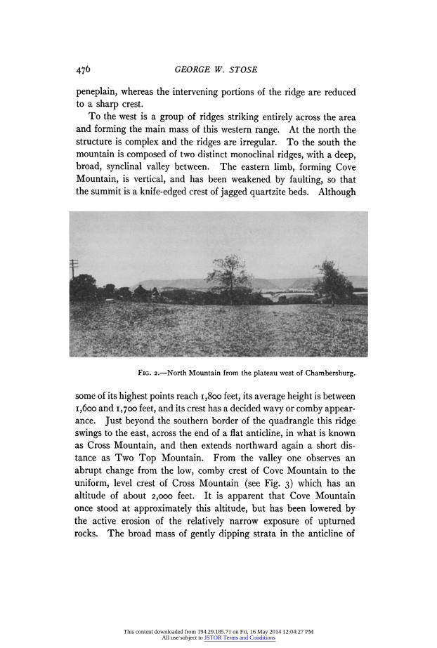
ridges form a very even and level sky line, which suggests at a glance that they are remnants of an old peneplain. As one approaches from the east North Mountain comes first into view, but extends into the area only about 6 miles. It is a double or canoe-shaped mountain, ending at the south in Parnell Knob. It is a closely folded syncline of quartzite, inclosing overlying shale in the center. The rocks are nearly vertical, and the quartzite ridges are conse- quently narrow and sharp. Although at a distance their tops fall in line with the crests of the more distant ridges and present a level sky line (see Fig. 2), on closer examination irregularities appear. The eastern limb of the syncline is cut through by water-gaps at several points, and its original height has been reduced so that the crest is irregular. Its highest points are slightly over i,8oo feet. The western limb is more even, but is cut by a wind-gap at the southern end. Its top lies between i,85o and 1,950 feet elevation, except near the northern border of the area, where it is locally 2,040 feet. At the southern end of the syncline two knobs, whose summits are broad and rounded, rise to 2,000 feet, and they may well represent portions of the old peneplain but slightly eroded.
The next ridge to the west is another canoe-shaped mountain, less compressed than the North Mountain syncline. It ends in Jordan Knob, a companion peak to Parnell Knob, and extends about the same distance into the quadrangle. The eastern limb of this fold is very steep and the ridge narrow and sharp-topped. In the western limb the dips are flatter and the mountain is broader and more massive. The eastern ridge has an altitude of about 1,950 feet. The general altitude of the western ridge is about 2,000 feet, but the highest peak rises to an altitude of 2,250 feet near the northern boundary of the quadrangle. The higher summits of this ridge are rounded, and in this respect possess the characteristics of an old
3 "Physiography of Maryland," Maryland Weather Service, Vol. I, Part 2, pp. 157-61.
475
This content downloaded from 194.29.185.71 on Fri, 16 May 2014 12:04:27 PMAll use subject to JSTOR Terms and Conditions
GEORGE W. STOSE
peneplain, whereas the intervening portions of the ridge are reduced to a sharp crest.
To the west is a group of ridges striking entirely across the area and forming the main mass of this western range. At the north the structure is complex and the ridges are irregular. To the south the mountain is composed of two distinct monoclinal ridges, with a deep, broad, synclinal valley between. The eastern limb, forming Cove Mountain, is vertical, and has been weakened by faulting, so that the summit is a knife-edged crest of jagged quartzite beds. Although
FIG. 2.-North Mountain from the plateau west of Chambersburg.
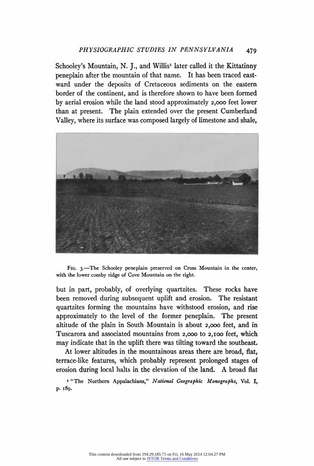
some of its highest points reach i,8oo feet, its average height is between 1,600oo and 1,700 feet, and its crest has a decided wavy or comby appear- ance. Just beyond the southern border of the quadrangle this ridge swings to the east, across the end of a flat anticline, in what is known as Cross Mountain, and then extends northward again a short dis- tance as Two Top Mountain. From the valley one observes an abrupt change from the low, comby crest of Cove Mountain to the uniform, level crest of Cross Mountain (see Fig. 3) which has an altitude of about 2,000 feet. It is apparent that Cove Mountain once stood at approximately this altitude, but has been lowered by the active erosion of the relatively narrow exposure of upturned rocks. The broad mass of gently dipping strata in the anticline of
476
This content downloaded from 194.29.185.71 on Fri, 16 May 2014 12:04:27 PMAll use subject to JSTOR Terms and Conditions

PHYSIOGRAPHIC STUDIES IN PENNSYLVANIA
Cross Mountain has resisted erosion, and its flat, broad top is prob- ably a remnant of the old peneplain surface.
Northward beyond Cove Gap the structure of Cove Mountain is synclinal, but is complicated by faulting. Although some of its summits rise to 2,050 feet, its general elevation is not over i,8oo.
The western monoclinal ridge, Tuscarora Mountain, is more massive than Cove Mountain because the rocks are not so steeply inclined and have withstood erosion better. Consequently it has a greater altitude, ranging from 1,950 to 2,050 feet, and a smoother
The middle-ground is the gently rolling upland north of St. Thomas.
crest line. Northward this monoclinal mountain forks by the develop- ment of a synclinal valley and another monoclinal ridge on the western side, the eastern ridge becoming anticlinal for a short distance. The anticlinal portion of the ridge is 2,450 feet in elevation, and is very broad and flat-topped. From its summit one looks over the tops of the other ridges, whose general level is 300 and more feet lower. It is evident that this peak was a monadnock in the old pene- plain. Its broad, rounded character is due to its partial reduction to the graded plain. Northward the eastern limb of the anticline is faulted off and the ridge continues as a monocline at about 2,250 feet elevation.
The monoclinal ridge, which branches off to the west, has an
477
This content downloaded from 194.29.185.71 on Fri, 16 May 2014 12:04:27 PMAll use subject to JSTOR Terms and Conditions

GEORGE W. STOSE
average elevation of 2,I00 feet, but rises to the height of the anticlinal ridge near their junction. The rocks become steeper toward the north, and the ridge contracts correspondingly in size and altitude.
South Mountain, on the east side of the valley, is more massive than the western range. The strata composing it are several thousand feet of interbedded Cambrian quartzites and shales, overlying older volcanics. The quartzites form the higher ridges, and the shales and volcanics are covered by a thick mask of the quartzite bowlders which prevent the erosion of deep valleys. The ridges are not straight, parallel, and even-topped like those of the western range, but are offset by cross folds and faults, and are cut through by transverse drainage, so that the crest is composed of numerous round-topped, elongate knobs and short ridges. Consequently they do not present so level a crest line as the western range.
In the heart of the mountains extending beyond the eastern border of the Chambersburg quadrangle, two high and very level tracts occur. Sandy Ridge and Snowy Mountain, south- east of Montalto, are broad and level-topped, and have a general altitude of about 2,000 feet, with a small knob rising to 2,100 feet. They are composed of nearly horizontal quartzite, forming the flat top of the anticlinal uplift of South Mountain. The other tract is Big Flat, occupying a large area on the top of the mountains north- east of Fayetteville. This also is the flat crest of an anticline developed to the west of the main axis of the mountain, and producing a promi- nent offset in the mountain front opposite Fayetteville. This plateau extends for 7 or 8 miles beyond the limits of the quadrangle at a general altitude of 2,000 feet, attaining an elevation of 2,1oo feet at two points. These two level tracts are undoubtedly remnants of the old peneplain, preserved at a height of 2,000 feet. The mono- clinal ridges along the front of the mountain, which once stood at this same altitude, have been reduced by erosion to 1,700 and 1,900 feet.
This peneplain, observed in both South Mountain and the Tusca- rora Mountain group, has long been recognized in this part of the Appalachians, and has been described by several geologists. Davis' named it the Schooley peneplain from its characteristic development on
I " Geographic Development of Northern New Jersey," Proceedings of the Boston Society of Natural History, Vol. XXIV, p. 377-
478
This content downloaded from 194.29.185.71 on Fri, 16 May 2014 12:04:27 PMAll use subject to JSTOR Terms and Conditions
PHYSIOGRAPHIC STUDIES IN PENNSYLVANIA
Schooley's Mountain, N. J., and Willis' later called it the Kittatinny peneplain after the mountain of that name. It has been traced east- ward under the deposits of Cretaceous sediments on the eastern border of the continent, and is therefore shown to have been formed by aerial erosion while the land stood approximately 2,000 feet lower than at present. The plain extended over the present Cumberland
Valley, where its surface was composed largely of limestone and shale,
FIG. 3.-The Schooley peneplain preserved on Cross Mountain in the center, with the lower comby ridge of Cove Mountain on the right.
but in part, probably, of overlying quartzites. These rocks have been removed during subsequent uplift and erosion. The resistant quartzites forming the mountains have withstood erosion, and rise approximately to the level of the former peneplain. The present altitude of the plain in South Mountain is about 2,000 feet, and in Tuscarora and associated mountains from 2,000 to 2,1oo feet, which may indicate that in the uplift there was tilting toward the southeast.
At lower altitudes in the mountainous areas there are broad, flat, terrace-like features, which probably represent prolonged stages of erosion during local halts in the elevation of the land. A broad flat
' "The Northern Appalachians," National Geographic Monographs, Vol. I, p. 189.
479
This content downloaded from 194.29.185.71 on Fri, 16 May 2014 12:04:27 PMAll use subject to JSTOR Terms and Conditions

GEORGE W. STOSE
3 miles in extent occurs at i,6oo feet elevation in the heart of South Mountain east of Montalto, and another .at 1,350 feet elevation at
Monterey, near the state line. Both of these are cut in the softer, ancient volcanic rocks underlying the quartzites. There are also numerous broad, flat divides at elevations from 1,450 to 1,750 feet. A broad gap near the southern end of North Mountain, at an elevation of 1,550 feet, represents the abandoned outlet of the stream which
formerly flowed longitudinally along the North Mountain syncline at this altitude, but was captured by Wilson Run at Franklin Gap. In Path Valley the shale spurs extending out from the mountain on the east are roughly terraced, two of the most prominent benches
lying at 1,100 and 1,200 feet. Cowan Gap, in Tuscarora Mountain,
through which Little Aughwick Creek formerly flowed into Path
Valley, is a broad gap at 1,200 feet. Correlation of these features has not been attempted.
Mr. Campbell, in his article on the Geographic Development of Northern Pennsylvania and Southern New York,' states that through- out the great valley (which includes the Cumberland Valley) the limestones which occupy the southeastern side are eroded deeper than the shales which occupy the northwestern portion. This is not the case in the Mercersburg-Chambersburg quadrangles and adjacent areas. The rocks in the eastern portion of the valley are the lower members of the Cambro-Ordovician limestone, and contain many hard, siliceous beds and several resistant sandstones. Some of these
produce prominent hills from 750 to 850 feet in altitude, a few
rising to 9oo and i,ooo feet. The upper beds of the limestone series, however, are purer and dissolve more readily, so that in the central
portion of the valley adjacent to the areas of overlying shale the surface is uniformly lower. Out of this lowland the shale hills rise abruptly, with steep escarpments, forming what may be called low plateaus.
There are two main belts of shale in the Mercersburg-Chambers- burg quadrangles: one west of Chambersburg and Greencastle, which crosses the quadrangles from north to south, and is cut longitudinally by East Conococheague and Back creeks; the other a smaller north and south belt in the vicinity of Mercersburg. These hills, or
plateaus, are in general very level-topped (see Fig. 2), although the 1 Loc cit., p. 283.
480
This content downloaded from 194.29.185.71 on Fri, 16 May 2014 12:04:27 PMAll use subject to JSTOR Terms and Conditions

PHYSIOGRAPHIC STUDIES IN PENNSYLVANIA
rocks composing them are broadly folded and sharply plicated, and
vary from fissile shale to soft but tough sandstone, which are alike planed off.
The northern portion of the larger shale belt, lying between East Conococheague and Back creeks, is the highest of the shale tracts. It is a narrow plateau extending from the junction of the two creeks to beyond the northern limits of the quadrangle. Along its axis it has a nearly uniform elevation of 750 feet, but rises at one point in the north to 780 feet, and decreases to 700 feet near its southern apex and on its margins. It has been considerably dissected along its borders, especially on the western side, where the tributaries of Back Creek have trenched it deeply, but the intervening spurs still retain their level character and to some extent their original height. The descent from the plateau level to the stream bottoms on either side is very steep and abrupt. This is especially pronounced on the east side, where the valley is a limestone lowland. On the west the shale tract extends beyond Back Creek, and the plateau character con- tinues at a somewhat reduced altitude, but attains 720 feet elevation at the northern border of the quadrangle.
There are no other extensive level tracts at this altitude in the area, but there are several scattered terraces and hilltops which approxi- mate this height. West of Mercersburg, near Cove Mountain, the shale hills rise to 700 feet, and a little farther north, where an inter- montane stream debouches at Cove Gap, an apron of mountain rock has been spread over these hills at an altitude of 74q0 feet. The same is true of a small 720-foot terrace just east of Fort Loudon, which was covered by mountain wash from Bear Valley when its outlet was at this altitude. Another hill covered with water-worn gravel occurs at Franklin Gap in North Mountain, the outlet of Wilson Run. This, however, has an altitude of 800 to 820o feet. The east branch of Little Antietam Creek, which occupies a re-entrant valley in South Mountain in the southeast corner of the area, has bowlder-covered terraces on both sides of the stream at 760 feet elevation. A similar but more extensive level tract covered by quartzite bowlders, occurs at Black Gap, in South Mountain, where the East Conococheague leaves the mountains and enters the valley. Here a very level plain extends for four miles along the creek at an elevation of 840 feet.
481
This content downloaded from 194.29.185.71 on Fri, 16 May 2014 12:04:27 PMAll use subject to JSTOR Terms and Conditions
GEORGE W. STOSE
Nowhere on its surface is bed rock exposed, and only one or two out- crops were found in stream cuttings on its borders, indicating a deep deposit of stream wash. In the limestone area on the eastern side of the valley there are numerous hilltops which approximate 740 to 760 feet in altitude, but many rise higher, and there is no apparent uniformity
It is clear that the valley in this region was once a nearly level plain, which has been deeply eroded, leaving remnants at approxi- mately 700 to 750 feet elevation. Campbell' has described a pene- plain preserved throughout this region on the shale at approximately this altitude. He has named it the Harrisburg peneplain from its typical development at Harrisburg, Pa., and assigns to it an early Tertiary age. It seems strange that the peneplain should be pre- served in the Chambersburg plateau, which is exposed to such active erosion from tributaries of two large creeks, whereas in more favorable areas only small remnants remain, but this is probably due to a soft but tough sandstone which is locally interbedded and infolded in the shale of this hill and has aided in its preservation. Nearly all the other areas occurring at this altitude were protected by a covering of stream gravels. At Black Gap the gravel-covered plain has a uniform altitude of 840 feet. The capping of gravel and cobble, judging from the nearest bed rock observed, is about 6o or 8o feet thick. East Conococheague Creek, which issues from the mountains at this point, is a large stream and drains a considerable portion of the moun- tains to the east. On leaving its confined channel in the gap and entering the open plain its velocity would be slackened, its transport- ing power lessened, and a portion of its load of mountain rock would be dropped. In this way a delta has been built up 6o or 8o feet above the general level of the peneplain. The great extent and level character of this delta bears evidence of a prolonged halt in the uplift of the land and of active erosion on the headwaters of the stream. The delta at Franklin Gap, which also stands at 800 to 840 feet ele- vation, was similarly built up above the plain. Other local delta gravels at about this height occur at smaller gaps along the mountain front. In Path Valley two well-marked terraces on the shale at 820
feet may represent this stage but at a higher level in the narrow tribu- tary valley.
1 Loc. cit., pp. 283-91.
482
This content downloaded from 194.29.185.71 on Fri, 16 May 2014 12:04:27 PMAll use subject to JSTOR Terms and Conditions

PHYSIOGRAPHIC STUDIES IN PENNSYLVANIA
The larger streams have very meandering, tortuous courses, not due to present aggraded conditions, since they occupy deep gorges in the broad shale areas and their grade is about ioo feet in 6 to io miles air line. These crooked streams originated on a graded plain, an additional evidence of the existence of a peneplain at about the Harrisburg level, and this mature drainage was rejuvenated by uplift and cut deep, sinuous valleys. The spurs between the bends of the streams in the shale areas are terraced at various levels, ranging in altitude from 580 to 68o feet. Many of the terraces and slopes along East and West Conococheague creeks are covered with quartzite bowlders transported from the mountains by these streams during the cutting of the gorges, but no such deposits have been found on the surface of the Chambersburg plateau.
As to the presence in this area of a lower peneplain of later Tertiary age equivalent to the Somerville peneplain of Davis, ds suggested by Campbell,' the evidence is not so clear. Along both Back Creek and East Conococheague Creek terraces at 680 feet are very con- spicuous, and the shale plateau near St. Thomas also attains this alti- tude. To the south the level tops of the central shale belt are all at 6oo to 620 feet, and in many cases this altitude is maintained to the ends of the spurs between the creek bends. Other spurs have been lowered to 580 and 56o feet. At Upton the 6oo-foot plain is very pro- nounced and extends several miles on to the limestone area to the northwest. In the western shale belt the upland is at 600 to 620 feet elevation, with a few higher tables previously mentioned nearer the mountains. The limestone tracts adjoining the shale have in general been reduced to a rolling lowland about 550 to 560 feet in altitude, which probably indicates a more recent epoch of erosion affecting these soluble rocks. The limestone area along East Conococheague Creek from Chambersburg south, however, stands at 600 to 620 feet elevation, forming a very level tract covered largely by stream gravel.
Of these later erosion features the most marked is the 6oo-foot plain which forms plateaus of relatively wide extent and level charac- ter. This, if any, represents the lower peneplain of late Tertiary age which Campbell correlates with the Somerville plain of Davis. The
i Loc. cit., p. 287.
483
This content downloaded from 194.29.185.71 on Fri, 16 May 2014 12:04:27 PMAll use subject to JSTOR Terms and Conditions

484 GEORGE W. STOSE
68o-foot terrace probably represents an earlier halt of short duration and the 560-foot lowland a very recent broadening of the limestone valleys.
There are recognized in this area, therefore, the Schooley pene- plain at 2,000 to 2,100 feet elevation forming the mountain summits, the Harrisburg peneplain at 750 feet on the higher shale hills, a pene- plain at 620 feet on the lower shale hills possibly equivalent to the Somerville plain of New Jersey, and intermediate uncorrelated ter- races at various levels.
GEORGE W. STOSE. WASHINGTON, D. C.
This content downloaded from 194.29.185.71 on Fri, 16 May 2014 12:04:27 PMAll use subject to JSTOR Terms and Conditions