Embed Size (px)
Citation preview
Lake Lothing Third Crossing Environmental Statement
The Lake Lothing (Lowestoft) Third Crossing Order 201[*]
_________________________________________________________________________
_________________________________________________________________________
Document 6.3: Environmental Statement Volume 3 Appendices
Appendix 12C
Piling Works Risk Assessment_________________________________________________________________________
Author: Suffolk County Council

Lake Lothing Third Crossing Environmental Statement
This page has intentionally been left blank
1069948-WSP-EGT-LL-RP-LE-0003 JUNE 2018PUBLICJUNE 2018 PUBLIC
Suffolk County Council
LAKE LOTHING THIRD RIVER CROSSING Interim Piling Works Risk Assessment
Suffolk County Council
LAKE LOTHING THIRD RIVER CROSSING Interim Piling Works Risk Assessment
TYPE OF DOCUMENT (VERSION) PUBLIC PROJECT NO. 62240712 OUR REF. NO. 1069948-WSP-EGT-LL-RP-LE-0003 DATE: JUNE 2018
WSP 1st Floor Station House Tithebarn Street, Exchange Station Liverpool L2 2QP Phone: +44 151 331 8100 WSP.com
LAKE LOTHING THIRD RIVER CROSSING WSP Project No.: 62240712 | Our Ref No.: 1069948-WSP-EGT-LL-RP-LE-0003 June 2018 Suffolk County Council
CONTENTS
1 INTRODUCTION 1
1.1 AUTHORISATION 1 1.2 SITE INFORMATION 1 1.3 OBJECTIVES 2 1.4 PREVIOUS REPORTS 2 1.5 ASSESSMENT 2
2 SITE SETTING 4
2.1 SITE HISTORY 4 2.2 SURROUNDING LAND USES 4 2.3 ENVIRONMENTAL SETTING 4 2.4 GROUND INVESTIGATION 5
3 CONTAMINATION ASSESSMENT 9
3.1 HUMAN HEALTH RISK ASSESSMENT 9 3.2 CONTROLLED WATERS RISK ASSESSMENT 10 3.3 GROUND GAS RISK ASSESSMENT 12 3.4 MARINE SEDIMENT TESTING 13
4 CONCEPTUAL SITE MODEL 14
4.1 INTRODUCTION 14
5 PILING RISK ASSESSMENT 15
5.1 PILE TYPE AND METHOD 15 5.2 POLLUTION SCENARIOS AND MITIGATION MEASURES 16 5.3 EXISTING INFRASTRUCTURE 18
6 CONCLUSIONS AND RECOMMENDATIONS 20
WSP LAKE LOTHING THIRD RIVER CROSSING June 2018 Project No.: 62240712 | Our Ref No.: 1069948-WSP-EGT-LL-RP-LE-0003
Suffolk County Council
6.1 CONCLUSIONS 20 6.2 RECOMMENDATIONS 20
TABLES Table 1 – Summary of VOC Exceedances > 10ppm 6 Table 2 - Summary of Visual and Olfactory Evidence of Contamination 7 Table 3 – Summary of Ground Gas Monitoring Results 12 Table 4 - Summary of Plausible Contaminant Linkages 14 Table 5 – Piling Works Risk Matrix with Pollution Scenarios 19
FIGURES Figure 1 – Location of the Scheme in Lowestoft 2
ANNEXES Annex A - Drawings Annex B - Risk Descriptors
LAKE LOTHING THIRD RIVER CROSSING WSP Project No.: 62240712 | Our Ref No.: 1069948-WSP-EGT-LL-RP-LE-0003 June 2018 Suffolk County Council Page 1 of 20
1 INTRODUCTION
1.1 AUTHORISATION The Piling Works Risk Assessment (PWRA) has been produced to support the design and Development Consent Order (DCO) process for the construction of a third river crossing over Lake Lothing.
1.2 SITE INFORMATION The site is approximately 21 ha in size and located in an urban environment in the centre of Lowestoft, Suffolk.
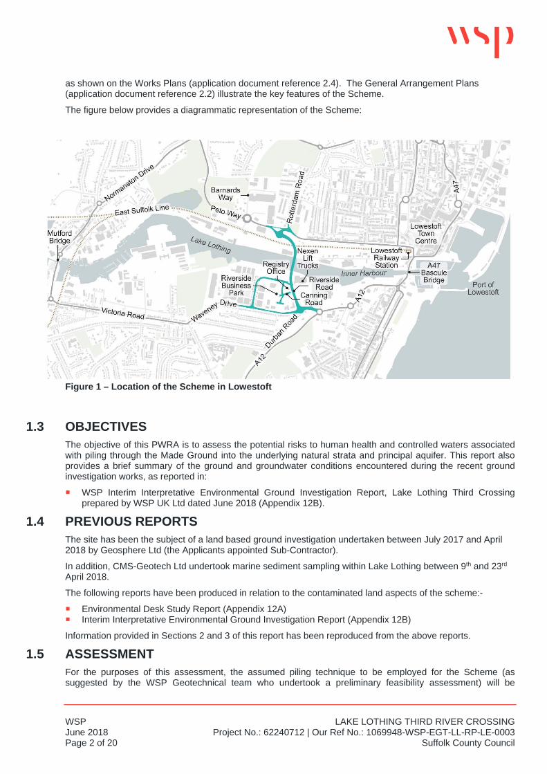
The site is located to the north and south of Lake Lothing. It is bounded to the south by Waveney Drive and to the north by Denmark Road. In the south east, the boundary is marked by the roundabout junction between the A12 and Waveney Drive and also the adjacent dock area. In the south west, the boundary is within a former industrial site immediately to the west of the Waveney District Council offices. In the north east, the boundary is at the end of Commercial Road and in the north west, the boundary is at the roundabout junction between Denmark Road and Peto Way.
The scheme involves the construction, operation and maintenance of a new bascule bridge highway crossing linking the areas north and south of Lake Lothing in Lowestoft, hereafter referred to as the Lake Lothing Third Crossing (the Scheme).
The Scheme would provide a new single-carriageway road crossing of Lake Lothing, consisting of a multi-span bridge with associated approach roads, and would comprise:
an opening bascule bridge over the Port of Lowestoft, in Lake Lothing; on the north side of Lake Lothing, a bridge over Network Rail's East Suffolk Line, and a reinforced earth
embankment joining that bridge, via a new roundabout junction, to the C970 Peto Way, between Rotterdam Road and Barnards Way; and
on the south side of Lake Lothing, a bridge over the northern end of Riverside Road including the existing access to commercial property (Nexen Lift Trucks) and a reinforced earth embankment (following the alignment of Riverside Road) joining this bridge to a new roundabout junction with the B1531 Waveney Drive.
The Scheme would be approximately 1 kilometre long and would be able to accommodate all types of vehicular traffic as well as non-motorised users, such as cyclists and pedestrians.
The opening bascule bridge design would allow large vessels to continue to use the Port of Lowestoft.
A new control tower building would be located immediately to the south of Lake Lothing, on the west side of the new highway crossing, to facilitate the operation of the opening section of the new bascule bridge.
The Scheme would also entail:-
the following changes to the existing highway network:
• the closure of Durban Road to vehicular traffic at its junction with Waveney Drive; • the closure of Canning Road at its junction with Riverside Road, and the construction of a replacement
road between Riverside Road and Canning Road to the west of the Registry Office; • a new access road from Waveney Drive west of Riverside Road, to provide access to property at
Riverside Business Park; • improvements to Kimberley Road at its junction with Kirkley Run; and • part-signalisation of the junction of the B1531 Victoria Road / B1531 Waveney Drive with Kirkley Run.
the provision of a pontoon for use by recreational vessels, located to the east of the new highway crossing, within the Inner Harbour of Lake Lothing; and
works to facilitate the construction, operation and maintenance of the Scheme, including the installation of road drainage systems; landscaping and lighting; accommodation works for accesses to premises; the diversion and installation of utility services; and temporary construction sites and access routes.
The works required for the delivery of the Scheme are set out in Schedule 1 to the draft DCO (application document reference 3.1), where they are referred to as "the authorised development", with their key component parts being allocated reference numbers, which correspond to the layout of the numbered works
WSP LAKE LOTHING THIRD RIVER CROSSING June 2018 Project No.: 62240712 | Our Ref No.: 1069948-WSP-EGT-LL-RP-LE-0003 Page 2 of 20 Suffolk County Council
as shown on the Works Plans (application document reference 2.4). The General Arrangement Plans (application document reference 2.2) illustrate the key features of the Scheme.
The figure below provides a diagrammatic representation of the Scheme:
Figure 1 – Location of the Scheme in Lowestoft
1.3 OBJECTIVES The objective of this PWRA is to assess the potential risks to human health and controlled waters associated with piling through the Made Ground into the underlying natural strata and principal aquifer. This report also provides a brief summary of the ground and groundwater conditions encountered during the recent ground investigation works, as reported in:
WSP Interim Interpretative Environmental Ground Investigation Report, Lake Lothing Third Crossing prepared by WSP UK Ltd dated June 2018 (Appendix 12B).
1.4 PREVIOUS REPORTS The site has been the subject of a land based ground investigation undertaken between July 2017 and April 2018 by Geosphere Ltd (the Applicants appointed Sub-Contractor).
In addition, CMS-Geotech Ltd undertook marine sediment sampling within Lake Lothing between 9th and 23rd April 2018.
The following reports have been produced in relation to the contaminated land aspects of the scheme:-
Environmental Desk Study Report (Appendix 12A) Interim Interpretative Environmental Ground Investigation Report (Appendix 12B)
Information provided in Sections 2 and 3 of this report has been reproduced from the above reports.
1.5 ASSESSMENT For the purposes of this assessment, the assumed piling technique to be employed for the Scheme (as suggested by the WSP Geotechnical team who undertook a preliminary feasibility assessment) will be
LAKE LOTHING THIRD RIVER CROSSING WSP Project No.: 62240712 | Our Ref No.: 1069948-WSP-EGT-LL-RP-LE-0003 June 2018 Suffolk County Council Page 3 of 20
conventional bored piles. These will pass through the made ground and Superficial deposits into the underlying Crag Formation. The current conceptual design is based on all piles terminating at depth in the Crag Formation
The assessment has been carried out with consideration to the guidance and information provided in the following documents:
Piling in layered ground: risks to groundwater and archaeology. Environment Agency (October 2006), Science Report SC020074/SR;
Piling into contaminated sites. Environment Agency National Groundwater and Contaminated Land Centres (February 2002); and
Piling and penetrative ground improvement methods on land affected by contamination: guidance on pollution prevention. Environment Agency (May 2001).
WSP LAKE LOTHING THIRD RIVER CROSSING June 2018 Project No.: 62240712 | Our Ref No.: 1069948-WSP-EGT-LL-RP-LE-0003 Page 4 of 20 Suffolk County Council
2 SITE SETTING
2.1 SITE HISTORY 2.1.1 NORTHERN SITE AREA
The earliest map provided by GroundSure dated 1883 indicates the site to be predominantly agricultural land with some small buildings and a railway line adjacent to the waterfront area.
Some industrial development occurred in the early 1900’s including a railway and associated land through the centre of the site and timber yard at the western end. However, no significant changes occurred until the 1970’s when most of the railways had been dismantled and by 1992, a new road (Peto Way) had been constructed through the site.
2.1.2 SOUTHERN SITE AREA The earliest map provided by GroundSure dated 1883 indicates the site to be predominantly agricultural land with marsh and mudflats. By the early 1900’s, many of the mudflats had been removed and formal waterfront wharfs appear from the waterside area. Some industry is present in the vicinity of the site including unlabelled works. By 1926 industrial development including a railway spur line had occurred across a large part of the site. The site remained largely industrial, including canning and processing works, ice works and boatbuilding until circa 2002 when the access roads for Riverside Business Park were constructed.
2.2 SURROUNDING LAND USES Immediate neighbouring land uses were as follows at the time of the Environmental Desk Study Report (Appendix 12A):
North - Residential properties, small commercial / industrial park and a small play park. East - Commercial Park, industrial area associated with the port / quayside, railway lines and residential
properties. South - Residential properties and a small commercial park. West - Derelict land, port / quayside industrial land and commercial properties.
2.3 ENVIRONMENTAL SETTING 2.3.1 PUBLISHED GEOLOGY
The British Geological Survey website 1 indicates the Superficial deposits underlying the site immediately to the north and south of the lake are clay and silt Tidal River or Creek Deposits. Immediately adjacent to the lake are alluvium deposits comprising clay, silt, sand and gravel. Beyond, towards Denmark Road in the north and Waveney Drive in the south is sand of the Happisburgh Glacigenic Formation. Bedrock geology is composed of sand of the Crag Group.
Made Ground is expected across the site due to its historical uses and is expected to be deepest in areas of infill and in the vicinity of dock/river walls.
2.3.2 HYDROGEOLOGY The superficial deposits underlying the site (Alluvial deposits, Tidal River or Creek Deposits and Happisburgh Glacigenic Formation) are classified as a Secondary (A) Aquifer. These are defined by the Environment Agency as permeable layers capable of supporting water supplies at a local rather than strategic scale, and in some cases forming an important source of base flow to rivers.
The underlying bedrock (Crag Group) is classified as a Principal Aquifer. These are defined by the Environment Agency as layers of rock or drift deposits that have high intergranular and/or fracture permeability
1 www.bgs.ac.uk
LAKE LOTHING THIRD RIVER CROSSING WSP Project No.: 62240712 | Our Ref No.: 1069948-WSP-EGT-LL-RP-LE-0003 June 2018 Suffolk County Council Page 5 of 20
- meaning they usually provide a high level of water storage. They may support water supply and/or river base flow on a strategic scale.
The site is not within a Source Protection Zone.
The nearest groundwater abstraction is approximately 1,300m to the north west.
2.3.3 HYDROLOGY The Lake Lothing watercourse splits the site in two and is recorded as a Primary River. There is a culverted watercourse (un-named in the Environmental Desk Study Report but understood to be the Kirkley Stream) beneath the south east part of the site.
No surface water or potable water abstractions are present within 2km of the site.
Much of the site is within Zone 3 and Zone 2 floodplain. The only sections not within floodplain are at the extremities of the site in the south east, south west, north east and north west corners.
Risk of flooding from the rivers and the sea varies from high in the centre of the site to medium and low towards the extremities of the site. The only sections of the site not at risk are in the south east, south west, north east and north west corners of the site.
2.4 GROUND INVESTIGATION The ground investigation undertaken in 2017/2018 by Geosphere Ltd generally confirmed the anticipated geological sequence above and is summarised below. Full details of the ground investigation works undertaken and the ground conditions encountered are presented in the WSP Interim Interpretative Environmental Ground Investigation Report (Appendix 12B).
Exploratory hole locations are presented on Drawing 1069948-WSP-ENG-LL-SK-LE-0020 – Sampling Locations Regulations 5(2)(a) Figure 12.2 presented in Annex A.
2.4.1 MADE GROUND NORTHERN SITE AREA Made ground was recorded at all exploratory hole locations and varied in thickness from 0.6m to 3.6m, although the base of the made ground in BHC06A was not found at 2.9m depth and may therefore be deeper. The made ground was generally granular and heterogeous in nature and was composed of detritus including concrete, charcoal, clinker, brick, tile, metal (including reinforcing bar), ash, asphalt, glass, wood, soot, pottery and cast iron.
The thickness of made ground varied across the site with no particular areas recording thicker made ground than others. It was expected that the thickest made ground would be encountered closest to the Lake Lothing quay walls where ground levels were expected to have been raised to create the quayside but this was not indicated on the Draft Engineers logs issued by Geosphere Ltd.
2.4.2 MADE GROUND SOUTHERN SITE AREA Made ground was recorded at all exploratory hole locations and varied in thickness from 0.75m to at least 3.7m, although this same location (BHC13 located close to the southern side of Lake Lothing) recorded possible made ground to in excess of 6.0m depth). The made ground was generally granular and heterogeous in nature and was composed of detritus including concrete, charcoal, clinker, brick, tile, metal (including reinforcing bar), ash, asphalt, glass, wood, soot, pottery and cast iron. Fragments of potential asbestos containing materials were recorded at TPC23 close to the Council offices.
The thickness of made ground varied across the southern site area although made ground was generally thickest closer to the Lake Lothing quay walls where ground levels are expected to have been raised historically to create the quayside.
2.4.3 CONCRETE & UNDERGROUND STRUCTURES Solid concrete up to at least 0.6m thick (maximum thickness recorded in BHC27 located close to the southern side of Lake Lothing) and asphalt / flexible surfacing up to 0.2m thick was recorded at a number of locations both at and below the surface. BHC101 located close to the southern side of Lake Lothing recorded concrete

WSP LAKE LOTHING THIRD RIVER CROSSING June 2018 Project No.: 62240712 | Our Ref No.: 1069948-WSP-EGT-LL-RP-LE-0003 Page 6 of 20 Suffolk County Council
2.0m thick where it varied from crumbling degraded concrete to solid layers. Three disused six inch pipes were located in the inspection pit for this borehole at a depth of 0.7m.
A small diameter clay pipe (possibly a redundant land drain) was encountered at WS101 and was infilled with clay with a hydrocarbon odour.
Another redundant pipe was recorded in TPC06 but no details of any infilling were provided.
2.4.4 NATURAL STRATA Alluvium Deposits Alluvial deposits have been encountered predominantly to the north of the Lake encountered as both granular and cohesive material.
The Granular Alluvium was generally recorded as dark grey, brown and yellow silty, clayey, gravelly fine to medium Sand with a strong natural organic odour. The gravels are described as angular to rounded flints.
The Cohesive Alluvium was generally recorded as dark grey and black sandy and silty Clay with some shell fragments. The material was described to have a strong natural organic odour.
Happisburgh Glacigenic Formation The Happisburgh Glacigenic Formation was encountered across the entire site, generally as medium dense to dense Sands, flint Gravels and gravelly Sand. At the top of the strata the material is described as being light and pale orange and brown but becomes darker and grey at depth.
Clay banding was encountered within the Sand matrix at varying depth but usually towards the base of the strata. It is generally light to dark grey laminated silty sometimes sandy Clay, with some incidences of flint gravels.
Crag Group The Crag Group was encountered underlying the Happisburgh Glacigenic Formation across the entire site and generally comprised dense to very dense dark grey medium grained sand with frequent white fine shell fragments, with some fine gravel and occasional clay layers.
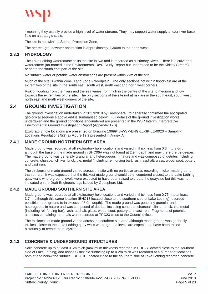
2.4.5 VISUAL AND OLFACTORY EVIDENCE OF CONTAMINATION The presence of volatile organic compounds was assessed by Geosphere Ltd at each exploratory hole using a Photo-Ionisation Detector (PID). The results are presented in the WSP Interim Interpretative Environmental Ground Investigation Report (Appendix 12B). Most results were zero with the maximum concentration of 486ppm recorded in WSC05.
All results above 10 ppm are presented in the Table below.
Table 1 – Summary of VOC Exceedances > 10ppm
Exploratory Hole reference
Approximate Depth (m)
Strata Type VOC Reading(s) (ppm)
BHC06 0.5 Made ground 122
BHC13
2.0 Made ground 34
3.0 Made ground 19
BHC17 0.2 Topsoil 12
0.4 Made ground 23
2.5 Clay 163
BHC19 2.0 Sand 35
3.0 Sand 33
LAKE LOTHING THIRD RIVER CROSSING WSP Project No.: 62240712 | Our Ref No.: 1069948-WSP-EGT-LL-RP-LE-0003 June 2018 Suffolk County Council Page 7 of 20
Other than the man-made detritus recorded within the made ground, visual and olfactory evidence of contamination was recorded by the Geosphere Ltd at the following locations.
Table 2 - Summary of Visual and Olfactory Evidence of Contamination
Exploratory Hole reference
Comment Strata Type Impacted Strata Depth (m bgl)
BHC04 Sulphurous and hydrocarbon odours and black staining.
Made ground 0.6m – 1.3m
BHC06 Hydrocarbon odour and black staining
Possible made ground 0.3m – 1.25m
Sheen on ground water Possible made ground 1.0m
BHC13 Hydrocarbon odour and black staining
Made ground and possible made ground
1.2m – 6.0m
BHC101 Hydrocarbon odour Concrete, made ground and natural sand.
0.2m – 4.0m
Sheen on groundwater Made ground 2.1m
BHC102 Hydrocarbon odour Made ground and natural gravel and sand
0.17m - 12.2m
BHC103 Hydrocarbon odour, sheen and staining
Natural sand 1.5m – 3.5m
WSC101 Hydrocarbon odour Redundant pipe within made ground
0.6m
WSC103 Hydrocarbon odour Natural sand 2.4m – 4.0m
TPC103 Sulphurous and hydrocarbon odours
Made ground and natural sand 1.2m – 2.2m
From the information presented in the table above, it would appear that the locations exhibiting hydrocarbon odours are mainly located in two distinct areas of the site. One in the southern part of the site, is located immediately between Riverside Road and Lake Lothing and is the location of the former East Anglia Ice
Exploratory Hole reference
Approximate Depth (m)
Strata Type VOC Reading(s) (ppm)
BHC22 0.3 Made ground 53
0.5 Made ground 98
BHC102 0.3 Concrete 62
2.5 Gravel 40 6
10.5 Sand 33 75
BHC103 4.5 Sand 25 7
7.0 Sand 13 6
WSC05 2.5 Clay 486
3.5 Sand 72
WSP LAKE LOTHING THIRD RIVER CROSSING June 2018 Project No.: 62240712 | Our Ref No.: 1069948-WSP-EGT-LL-RP-LE-0003 Page 8 of 20 Suffolk County Council
Works, a tyre depot, a cold store and a boat building yard which was located to the east and may have encroached partly onto this area. The other area is in the north of the site, located between the railway line and Denmark Road and is a former coal depot.
2.4.6 MARINE SEDIMENTS CMS-Geotech Ltd undertook both surface grab samples and vibrocore samples to a nominal 4m below lake bed.
The CMS-Geotech vibrocore logs presented in Annex D of the WSP Interim Interpretative Environmental Ground Investigation Report (Appendix 12B) indicate that the shallow sediments within Lake Lothing comprise silt between 0.4m and 1.6m thickness overlying sand. Clay, silt and gravel layers were also recorded within the sand.
LAKE LOTHING THIRD RIVER CROSSING WSP Project No.: 62240712 | Our Ref No.: 1069948-WSP-EGT-LL-RP-LE-0003 June 2018 Suffolk County Council Page 9 of 20
3 CONTAMINATION ASSESSMENT This Section summarises the findings of human health, controlled waters and ground gas risk assessments. Full details are presented in Section 6 of WSP’s Interim Interpretative Environmental Ground Investigation Report (ref. 1069948-WSP-EGT-LL-RP-LE-0002) dated June 2018 (Appendix 12B).
3.1 HUMAN HEALTH RISK ASSESSMENT 3.1.1 PUBLIC OPEN SPACE END USE
Hydrocarbon odours and / or sheens were identified at a number of locations during the ground investigation as detailed in Section 2.4.5, Table 2 above. All except two of these locations were targeted for chemical testing with none of the results exceeding the hydrocarbon Generic Assessment Criteria (GAC).
Natural Ground (Southern Site Area) The following contaminants of concern (CoC) have been identified from the screening of natural ground in the southern site area:-
Alkaline pH at one location – BHC20 - pH10.4 compared to a screening value of pH9.5, Acid pH at one location – BHC26 - pH4.8 compared to a screening value of pH5.5.
Natural Ground (Northern Site Area) No CoC were identified in natural ground within the northern site area.
Made Ground (Southern Site Area) The following CoC’s have been identified from the screening of made ground in the southern site area:-
Asbestos was recorded by the chemical testing laboratory in one sample (and potential asbestos is recorded on the Engineers logs in TPC23):-
• BH102 at 0.3m depth as fibres and clumps of chrysotile.
Benzo-a-pyrene at two locations – WSC23 (26mg/kg) and BHC31 (12mg/kg) exceeded the GAC of 11mg/kg.
Alkaline pH at five locations – TPC21 (pH9.6), BHC102 (pH11.2), BHC101 (pH10.3) and WSC16 (pH10.5) exceeded the GAC of pH9.5,
Lead at one location – BHC31 – 1500mg/kg compared to a screening value of 808mg/kg.
Made Ground (Northern Site Area) The following COC’s have been identified from the screening of made ground in the southern site area:-
Asbestos was recorded by the chemical testing laboratory in one sample:-
• TPC02 at 0.3m depth as cement bound chrysotile,
Benzo-a-pyrene at one location – IPC01 (12mg/kg compared to a GAC of 11mg/kg, Alkaline pH at six locations – TPC101 (pH9.9), TPC04 (pH9.8), BHC02 (pH11), TPC02 (pH11.8), BHC08
(pH10.10) and BHC10 (pH10) values exceeded the GAC of pH9.5.
3.1.2 COMMERCIAL INDUSTRIAL END USE Hydrocarbon odours and / or sheens were identified at a number of locations during the ground investigation as detailed in Section 2.4.5, Table 2 above. All except two of these locations were targeted for chemical testing with none of the results exceeding the hydrocarbon GAC’s.
Natural Ground (Southern Site Area) The following CoC’s have been identified from the screening of natural ground in the southern site area:-
Alkaline pH at one location – BHC20 - pH10.4 compared to a screening value of pH9.5, Acid pH at one location – BHC26 - pH4.8 compared to a screening value of pH5.5.
Natural Ground (Northern Site Area) No CoC were identified in natural ground within the northern site area.
WSP LAKE LOTHING THIRD RIVER CROSSING June 2018 Project No.: 62240712 | Our Ref No.: 1069948-WSP-EGT-LL-RP-LE-0003 Page 10 of 20 Suffolk County Council
Made Ground (Southern Site Area) The following CoC’s have been identified from the screening of made ground in the southern site area:-
Asbestos was recorded by the chemical testing laboratory in one sample (and potential asbestos is recorded on the Engineers logs in TPC23):-
• BH102 at 0.3m depth as fibres and clumps of chrysotile.
Alkaline pH at five locations – TPC21 (pH9.6), BHC102 (pH11.2), BHC101 (pH10.3) and WSC16 (pH10.5) exceeded the GAC of pH9.5,
Lead at one location – BHC31 – 1,500mg/kg compared to a screening value of 1,390mg/kg.
Made Ground (Northern Site Area) The following CoC’s have been identified from the screening of made ground in the southern site area:-
Asbestos was recorded by the chemical testing laboratory in one sample:-
• TPC02 at 0.3m depth as cement bound chrysotile,
Alkaline pH at six locations – TPC101 (pH9.9), TPC04 (pH9.8), BHC02 (pH11), TPC02 (pH11.8), BHC08 (pH10.10) and BHC10 (pH10) values exceeded the GAC of pH9.5.
3.2 CONTROLLED WATERS RISK ASSESSMENT 3.2.1 RISKS TO AQUIFER
Soil Leachability Testing Screening of soil leachate test results from the ground investigation identified the following minor Water Quality Standards (WQS) exceedances:-
Alkaline pH – two locations - BHC02 (pH11) and BH102 (pH10.4) compared to a WQS of 10, Arsenic – one location – BHC05 (25µg/l) compared to a WQS of 10µg/l, Chromium – one location – BHC08 (52µg/l) compared to a WQS of 50µg/l, Nickel – one location – BHC08 (65µg/l) compared to a WQS of 20µg/l, Lead – three locations, BHC08 (19µg/l), IPC01 (25µg/l) and BH102 (14µg/l) compared to a WQS of 10µg/l, Aliphatic hydrocarbons C12-C16 – BHC19 (310µg/l) compared to a WQS of 300µg/l, Aromatic hydrocarbons C12-C16 – BHC13 (110µg/l) compared to a WQS of 90µg/l.
It should be noted that the limits of detection for benzo(a)pyrene and total PAH are in excess of the screening values. Due to the low concentrations of the limits of detection, any exceedences are not considered likely to be significant, particularly as there are no significant exceedences in any other speciated hydrocarbon results.
Groundwater Sampling 4/5th January 2018 Screening of two water samples (BHC02 and BHC102) taken by Geosphere on 4th and 5th January 2018 did not identify any WQS exceedances.
It should be noted that the limits of detection for total PAH and benzo(a)pyrene are in excess of the screening values.
Groundwater Sampling 1st Monitoring Visit Screening of 8 groundwater samples identified the following minor exceedances of the WQS;-
Alkaline pH – five locations (BHC09, BHC24(dual well), BHC01 and BHC14) recorded values between pH11.7 and pH13.2 compared to a WQS of pH10,
Sulphate – one location – BHC01 (350µg/l) compared to a WQS of 250µg/l, Arsenic – one location – BHC27 (17µg/l) compared to a WQS of 10µg/l, Chromium – one location – BHC01 (160µg/l) compared to a WQS of 50µg/l, Nickel – two locations – BHC24 (77µg/l) and BHC01 (43µg/l) compared to a WQS of 20µg/l.
It should be noted that the limits of detection for total PAH and benzo(a)pyrene are in excess of the screening values.
Groundwater Sampling 2nd Monitoring Visit Screening of 9 groundwater sampling identified the following exceedances of the WQS:-
LAKE LOTHING THIRD RIVER CROSSING WSP Project No.: 62240712 | Our Ref No.: 1069948-WSP-EGT-LL-RP-LE-0003 June 2018 Suffolk County Council Page 11 of 20
Alkaline pH - three locations (BHC24(dual well) and BHC01 recorded values between pH11.4 and pH12.6 compared to a WQS of pH10,
Nickel - two locations BHC24 (41µg/l) and BHC01 (30µg/l) compared to a WQS of 20µg/l.
It should be noted that the limits of detection for total PAH and benzo(a)pyrene are in excess of the screening values.
3.2.2 RISKS TO LAKE LOTHING SURFACE WATER Soil Leachability Testing Screening of soil leachate test results from the ground investigation identified the following WQS exceedances:-
Cadmium – one location. 0.21µg/l compared to a WQS of 0.2µg/l, Copper – twelve locations. 4.2 µg/l to 32 µg/l compared to a WQS of 3.76 µg/l, Mercury – two locations. 0.52 µg/l to 0.53µg/l compared to a WQS of 0.07µg/l, Nickel – One location. 65µg/l compared to a WQS of 8.6µg/l, Lead – 16 locations. 1.3µg/l to 25µg/l compared to a WQS of 1.3µg/l, Zinc – four locations. 7.8µg/l to 190µg/l compared to a WQS of 6.8µg/l, Anthracene – two locations. 0.15µg/l and 2.8µg/l compared to a WQS of 0.1µg/l, Fluoranthene – two locations. 2.2µg/l and 7.6µg/l compared to a WQS of 0.0063µg/l,
It should be noted that the limits of detection for cyanide, mercury, hexavalent chromium, fluoranthene, benzo(b)fluoranthene, benzo(k)fluoranthene, benzo(a)pyrene and benzo(ghi)perylene are in excess of the screening values.
Surface Water Sampling The surface water sampling undertaken by CMS-Geotech at four locations within Lake Lothing on 19th April 2018 identified the following contaminants in excess of the relevant WQS:-
Zinc – exceedances in all four samples with concentrations varying from 8.88µg/l to 26.8µg/l compared to a WQS of 6.8µg/l.
Lake Lothing is an operating port and it is probable that these results can be attributed to the presence of sacrificial zinc anodes on the hulls of ships using the port.
It should be noted that the limits of detection for both cadmium and chromium are in excess of the screening values.
Groundwater Sampling 4/5th January 2018 Screening of two water samples (BHC02 and BHC102) taken by Geosphere on 4th and 5th January 2018 identified minor exceedances of the WQS for;-
Copper - one location – BHC102 (8.6µg/l) compared to a WQS of 3.76µg/l. , Nickel - one location – BHC102 (9.9µg/l) compared to a WQS of 8.6µg/l. , Zinc two locations – BHC102 (24µg/l) and BHC02 (12µg/l) compared to a WQS of 6.8µg/l. .
It should be noted that the limits of detection for cyanide, mercury, hexavalent chromium, fluoranthene, benzo(b)fluoranthene, benzo(k)fluoranthene, benzo(a)pyrene, benzo(ghi)perylene, 2,4-dichlorophenol, 1,2,4-Trichlorobenzene, hexachlorobenzene and total phenols are in excess of the screening values.
Groundwater Sampling 1st Monitoring Visit Screening of 8 groundwater samples identified exceedances of the WQS for:-
Copper – four locations, 4.8µg/l to 61µg/l compared to a WQS of 3.76µg/l, Nickel – five locations, 11µg/l to 77µg/l compared to a WQS of 8.6µg/l, Lead – two locations, 1.8µg/l to 5.2µg/l compared to a WQS of 1.3µg/l, Zinc – four locations, 7µg/l to 17µg/l compared to a WQS of 6.8µg/l, Hexavalent chromium – one location BHC01 (160µg/l) compared to a WQS of 0.6µg/l,
It should be noted that the limits of detection for cyanide, mercury, hexavalent chromium, fluoranthene, benzo(b)fluoranthene, benzo(k)fluoranthene, benzo(a)pyrene, benzo(ghi)perylene and total phenols are in excess of the screening values.
WSP LAKE LOTHING THIRD RIVER CROSSING June 2018 Project No.: 62240712 | Our Ref No.: 1069948-WSP-EGT-LL-RP-LE-0003 Page 12 of 20 Suffolk County Council
Groundwater Sampling 2nd Monitoring Visit Screening of 9 groundwater samples identified exceedances of the WQS for:-
Copper – two locations, BHC24 (19µg/l) and BHC01 (36µg/l) compared to a WQS of 3.76µg/l, Mercury – one location, BHC24 (0.68µg/l compared to a WQS of 0.07µg/l, Nickel – four locations, 8.7µg/l to 41µg/l compared to a WQS of 8.6µg/l, Lead – one locations, (BHC01) 3.8µg/l compared to a WQS of 1.3µg/l, Zinc – one location, (BHC02) 11µg/l compared to a WQS of 6.8µg/l, Hexavalent chromium – one location BHC01 (40µg/l) compared to a WQS of 0.6µg/l,
It should be noted that the limits of detection for cyanide, mercury, hexavalent chromium, fluoranthene, benzo(b)fluoranthene, benzo(k)fluoranthene, benzo(a)pyrene, benzo(ghi)perylene and total phenols are in excess of the screening values.
3.2.3 DISCUSSION There is some olfactory/ visual evidence of the presence of hydrocarbons in the vicinity of the exploratory holes CPTC13, BHC13, BHC101, BHC102, BHC103 and WSC103 near the southern bank of Lake Lothing (and in a number of other isolated locations). In addition, there are some associated VOC readings (identified using a PID meter during ground investigation) and minor theoretical hydrocarbon exceedances in soil leachate screening values.
Sampling of groundwater from monitoring well installations (adopting best practice of purging) within adjacent boreholes (BHC102, BHC14 and BHC27) do not show any exceedances of groundwater screening values for hydrocarbons. It is therefore concluded that although there is some evidence of hydrocarbon presence in a number of locations on site, particularly near the southern bank of Lake Lothing, the analysis of soil, soil leachate and groundwater samples indicate that the concentrations are not significant. It is possible that minor spillages have occurred in the past or that any more significant spillages have dispersed with time due to the generally permeable nature of the sub-strata on site.
3.3 GROUND GAS RISK ASSESSMENT To date, two of six rounds of ground gas monitoring have been undertaken by the Ground Investigation Contractor.
Atmospheric pressure during the first monitoring visit varied between 1006mb and 1016mb as recorded by the gas analyser. www.weatheronline.co.uk recorded a rising trend for the region.
During the second visit, atmospheric pressure as recorded by the gas analyser varied between 1002mb and 1025mb which was recorded by www.weatheronline.co.uk as a falling trend. The reading for BHC01 of 1002mb is believed to be a transcribing error as all except one location has atmospheric pressure recorded between 1021 and 1025mb.
Table 3 – Summary of Ground Gas Monitoring Results
Exploratory Hole
Max Flow Rate (lhr-1) Max Methane (% v/v)
Max Carbon Dioxide (% v/v)
Methane GSV
Carbion Dioxide GSV
BHC01 0.9 <0.1 0.5 0.0009 0.0045
BHC02 <0.1 <0.1 3.6 0.0001 0.0036
BHC07 7.4 (recorded at start) 0.1 0.2 0.0074 0.0148
Maximum steady flow of 0.1 0.0001 0.0002
BHC08 0.9 (recorded at start) <0.1 <0.1 0.0009 0.0009
Maximum steady flow of <0.1 0.0001 0.0001
BHC09 -0.3 0.1 <0.1 0.0003 0.0003
BHC14 -0.3 <0.1 <0.1 0.0003 0.0003
LAKE LOTHING THIRD RIVER CROSSING WSP Project No.: 62240712 | Our Ref No.: 1069948-WSP-EGT-LL-RP-LE-0003 June 2018 Suffolk County Council Page 13 of 20
Exploratory Hole
Max Flow Rate (lhr-1) Max Methane (% v/v)
Max Carbon Dioxide (% v/v)
Methane GSV
Carbion Dioxide GSV
BHC24(P) 50.4 (recorded at the start) 0.1 <0.1 0.0504 0.0504
Maximum steady flow of 0.3 0.0003 0.0003
BHC24(GG) -0.3 (recorded at the start) <0.1 0.6 0.0003 0.0018
Maximum steady flow of <0.1 0.0001 0.0006
BHC27 -1.6 (recorded at the start) <0.1 <0.1 0.0016 0.0016
Maximum steady flow of -0.9 0.0009 0.0009
BHC102 <0.1 <0.1 0.2 0.0001 0.0002
Based on the maximum steady flows, the GSV ranged between 0.0001 and 0.0045. All monitoring wells are therefore classified as Characteristic Situation 1 indicating very low risk from ground gases.
It should be noted that where the maximum flow was recorded at the start of the monitoring (italics in the table above), the GSV ranged from 0.0003 to 0.0504, which does not change the Characteristic Situation.
3.4 MARINE SEDIMENT TESTING The chemical test results from the sediment grab samples and the vibrocore sediment samples have been assessed against the CEFAS (Centre for Environment, Fisheries and Aquaculture Science) criteria for offshore disposal. In addition, the vibrocore samples were also subjected to waste acceptance criteria (WAC) testing to assess potential onshore disposal routes.
3.4.1 CEFAS ASSESSMENT The tables in Annex F of Appendix 12B present the comparison of the sample results against the current CEFAS Action Levels which was undertaken to establish the overall concentrations of contamination present.
The action levels stated are not ‘pass/fail’ criteria but, in general, contaminant levels below action level 1 are considered unlikely to influence a decision by the MMO on dredge disposal, pursuant to the Deemed Marine Licence (DML). Dredged material with contaminant levels above action level 2 is generally considered unsuitable for sea disposal. Dredged material with contaminant levels between action levels 1 and 2 may require further testing pursuant to the operation of the DML.
Of the 12 grab samples, 11 showed levels of trace metal contaminants for at least one determinant above the CEFAS Action Level 1 values, the most common contaminant being nickel. No samples had levels above the CEFAS Action Level 2 for any determinant.
Of the 32 vibrocore samples, 10 showed levels of trace metal contaminants for nickel, cadmium and arsenic above the CEFAS Action Level 1 values, the most common contaminant being nickel. No samples had levels above the CEFAS Action Level 2 for any determinant.
It is therefore considered that the sediments considered unlikely to have an unacceptable impact from a contamination perspective if they are mobilised during and / or after construction. It is also considered that the sediments are likely to be suitable for offshore disposal subject to gaining approval from the licensing authority.
WSP LAKE LOTHING THIRD RIVER CROSSING June 2018 Project No.: 62240712 | Our Ref No.: 1069948-WSP-EGT-LL-RP-LE-0003 Page 14 of 20 Suffolk County Council
4 CONCEPTUAL SITE MODEL
4.1 INTRODUCTION This Section summarises the Conceptual Site Model from the WSP Interim Interpretative Environmental Ground Investigation Report (Appendix 12B). Plausible source-pathway-receptor contaminant linkages have been refined in line with industry good practice (principally CLR11).
Table 4 provides the potential contaminant linkages that are considered to be plausible for the future use of the site.
Table 4 - Summary of Plausible Contaminant Linkages
Potential Contaminants
Potential Pathways
Potential Receptors Comments
Free asbestos fibres in made ground soil
Inhalation of asbestos fibres.
Future site users Future maintenance workers
Extensive hard standing will restrict exposure following construction but exposure during construction and during maintenance works cannot be discounted. The presence of asbestos elsewhere within the made ground cannot be discounted therefore if made ground materials are placed in landscaping areas, a capping layer will also need to be considered to minimise the risk to site users and adjacent site users from inhalation of fibres.
Contaminants in soil
Dermal contact, ingestions and inhalation of contaminated made ground, soil particles and fugitive dust.
Future site users Future maintenance workers
Extensive hard standing will restrict exposure at most locations except where landscaping is proposed. Detected potential contaminants limited to benzo-a-pyrene, pH and lead.
Leachable contaminants and contaminants in groundwater
Vertical leaching from impacted soil and lateral migration of impacted groundwater derived from on-site sources.
Superficial geology Secondary (A) aquifer and bedrock Principal aquifer. Lake Lothing surface water
Shallow groundwater samples appear to have been impacted slightly by metals but this does not appear to have been replicated in the deeper groundwater samples although some minor impact has been identified. There is a theoretical risk to surface waters from leachable contaminants in soil including minor hydrocarbon exceedances. Extensive hard standing will limit rainfall percolation and leachate potential and the identified exceedances of the WQS criteria are generally not significantly elevated. Whilst a theoretical contaminant linkage is considered likely to exist, an unacceptable risk to controlled waters is considered unlikely.
LAKE LOTHING THIRD RIVER CROSSING WSP Project No.: 62240712 | Our Ref No.: 1069948-WSP-EGT-LL-RP-LE-0003 June 2018 Suffolk County Council Page 15 of 20
5 PILING RISK ASSESSMENT
5.1 PILE TYPE AND METHOD As the piling contractor has not yet been appointed for the Scheme, the information presented below is conceptual. As such, recommendations to help inform detailed design are set out in section 6 of this document.
Due to the inherently variable nature of the Made Ground, the soft compressible nature of the lake bed silts and the high loads required to support the structures, conventional non-displacement (bored) piled foundations are considered the most appropriate technique for this site, and have therefore been considered in this assessment.
Two bridge supports are currently proposed within the Lake and the reference design indicates that 18 piles at each support location will be sufficient. Three bridge supports are currently proposed at the northern bank with five at the southern bank, each with between 12 and 18 piles. A reference design is proposed comprising bored piles founded within the Crag Formation.
It is anticipated that temporary casing will be driven through the shallow superficial deposits to minimise the inflow of groundwater and loose soils (and potentially contaminated soils/ groundwater) into the excavation as boring progresses. Permanent casings may be required for the piles excavated within cofferdams in Lake Lothing extending a shallow depth into the lake bed. A combination of end bearing and shaft resistance was considered when the outline design was undertaken.
Bored piles are considered to be the most appropriate pile type for the ground conditions at Lake LothingThe irregular interface between the pile and the soil (below the permanent casing in the case of piles excavated through the lake bed) minimises the creation of any pathways for the migration of any contamination present in the upper made ground or natural deposits to the underlying Principal Aquifer (Crag Deposits). The uppermost surface of the Crag Deposits is generally encountered at a depth of approximately 15 -20m so any permanent casings placed will not extend to these deposits. This approach will minimise any potential migration of any contamination present in near surface soils. In any case, only a limited amount of contamination has been identified by the ground investigation by analysing soil, leachate and groundwater samples (mainly in the near surface deposits). Driven piles are considered to be less suitable as some types, such as pre-cast concrete piles, can introduce preferential migration pathways due to the smooth surface of the pile. Driving piles can also allow potentially contaminated soils to be dragged along the shaft of the pile or below the base of the pile while driving. Driven piling is an inherently more noisy technique than bored piling and hence boring is considered to be more suitable at this location due to the proximity of residential and commercial properties.
In the proposed construction technique, boring will take place through the temporary casing by conventional augering techniques and progress beneath the base of the casing under the support of a dense fluid such as bentonite (a naturally occurring mineral) to maintain a positive hydrostatic head due the presence of granular deposits and groundwater at this depth. Once excavated to the required depth, the concrete will be injected from the base using a tremie pipe, displacing the bentonite at the surface as the pile is formed.
In summary, conventional bored piles are considered to provide the most suitable technique for minimising the risk of mobilising any potential contamination present and creating preferential pathways for migration; the key features and benefits to this piling method in the context of this development are:
The technique proposed involves temporarily casing the upper portion of ground (and then excavating through bentonite slurry) which will minimise the risk of contaminants migrating downwards during excavation.
The technique involves bringing all arisings including any potentially contaminated soils to the surface (and placing them on an impermeable membrane, if necessary) and allowing transfer to appropriately licensed waste disposal facilities.
The positive hydrostatic pressure of the concrete that is introduced prevents voids and pathways being created along the soil/ concrete interface.
5.1.1 DESIGN RESPONSIBILITY Specific pile design will remain the responsibility of a specialist contractor who will design a scheme based on the available ground information, the loads to be carried, the preferred construction sequence and their own proprietary techniques.
WSP LAKE LOTHING THIRD RIVER CROSSING June 2018 Project No.: 62240712 | Our Ref No.: 1069948-WSP-EGT-LL-RP-LE-0003 Page 16 of 20 Suffolk County Council
The detailed piling design will follow regulatory guidance and take full cognisance of any contaminated soils and groundwater identified on the site. Appropriate site management and pile installation quality control measures will be in place during pile installation.
5.2 POLLUTION SCENARIOS AND MITIGATION MEASURES Environment Agency guidance document ‘Piling and Penetrative Ground Improvement Methods on Land Affected by Contamination: Guidance on Pollution Prevention’ (2001) presents guidance on the potential environmental and human health risks associated with different piling techniques. Six possible pollution scenarios are identified and described, representing situations where there is concern that piling or penetrative ground improvement operations have potential to cause a risk to receptors:
Scenario 1 - Creation of preferential pathways, through a low permeability layer (an aquitard), to allow potential contamination of an underlying aquifer;
Scenario 2 - Creation of preferential pathways, through a low permeability surface layer, to allow upward migration of landfill gas, soil gas, or contaminant vapours to the surface;
Scenario 3 - Direct contact of site workers and others with contaminated soil arisings which have been brought to the surface;
Scenario 4 - Direct contact of the piles or engineered structures with contaminated soil or leachate causing degradation of pile materials (where the secondary effects are to increase the potential for contaminant migration);
Scenario 5 - The driving of solid contaminants down into an aquifer during pile driving; and
Scenario 6 - Contamination of groundwater and, subsequently, surface water by concrete, cement paste, or grout.
Where potential contaminant linkages have been identified, mitigation measures have been outlined. A summary of each pollution scenario is shown in Table 5. The identification of potential “contaminant linkages” is a key aspect of the evaluation of potentially contaminated land. An approach based on the UK CIRIA report C552 (Contaminated Land Risk Assessment: A Guide to Good Practice, 2001) has been adopted within this table and the matrices used to generate the risk level are presented in Annex B.
The design for conventional bored piles is likely to use concrete, cement paste or grout and so this pollution scenario could arise if site works are not properly managed. Consideration to pile material will be given during design and an appropriate material selected for use that will harden at an appropriate timescale when installed. In addition, volumes of piling concrete are to be monitored to ensure that there is no significant loss of material during pile formation.
In view of the above assessment, the potential for contamination of groundwater from the proposed piling activities is therefore considered to be LOW.
5.2.1 POLLUTION SCENARIO 1 – CREATION OF PREFERENTIAL PATHWAYS THROUGH AN AQUITARD, TO ALLOW POTENTIAL CONTAMINATION OF AN UNDERLYING AQUIFER It is assumed that piles would penetrate through all soil strata identified in the ground investigation report and be founded in the Crag Deposits (Principal Aquifer), the surface of which is encountered generally at a depth of 15-20m bgl. The soils encountered on site are predominantly granular with no continuous low permeability surface layers being identified and hence are considered to be in hydraulic continuity. However, due to the pile technique proposed (which will create intimate contact between the concrete and the surrounding soils), the fact that limited contamination has been identified on site (which is mainly confined to the shallow made ground deposits) and that shallow groundwater is already in hydraulic continuity with the Crag Deposits, it is considered
LAKE LOTHING THIRD RIVER CROSSING WSP Project No.: 62240712 | Our Ref No.: 1069948-WSP-EGT-LL-RP-LE-0003 June 2018 Suffolk County Council Page 17 of 20
that the piles will not create an additional pathway for migration of any contamination present in near surface soils. Scenario 1 is considered to represent a low risk.
5.2.2 POLLUTION SCENARIO 2 – CREATION OF PREFERENTIAL PATHWAYS THROUGH A LOW PERMEABILITY SURFACE LAYER, TO ALLOW UPWARD MIGRATION OF SOIL GAS OR CONTAMINANT VAPOURS TO THE SURFACE Conventional bored piles have the potential to create a pathway for any soil gas or contaminant vapours to migrate to the surface. However, no continuous low permeability surface layers have been identified and Made Ground deposits are noted to be generally granular at Lake Lothing. Gas monitoring undertaken and reported in the Interpretative Environmental Ground Investigation report (Appendix 12B) identified that all concentrations of methane and carbon dioxide are below threshold values (1.0% v/v and 5.0% v/v, respectively) with associated negligible flow rates once steady state has been reached. Based on the monitoring data, the site was classified as Characteristic Situation 1 (Very low risk). Scenario 2 is not considered to be a concern for the site due to the proposed end-use (bridge structure/ highway/ landscaping) and the absence of any significant concentrations of ground gas. In relation to the proposed Control Building, ground gas has not been recorded at concentrations that require specific gas protection measures over and above standard construction techniques.
5.2.3 POLLUTION SCENARIO 3 – DIRECT CONTACT OF SITE WORKERS AND OTHERS WITH CONTAMINATED SOIL ARISINGS THAT HAVE BEEN BROUGHT TO THE SURFACE WSP’s Interpretative Environmental Ground Investigation report (Appendix 12B) has identified only limited contamination present, mainly in the made ground deposits. All made ground was tested for the presence of asbestos and chrysotile was identified in two soil samples (from TPC02C as cement and BHC102 as fibres/ clump, both at 0.3m depth). A ‘fragment of potential asbestos containing material’ was also described in the trial pit log for TPC23, at 0.3m depth. These shallow soils could pose a potential risk to construction workers and third parties.
On the basis that appropriate health and safety training, planning and monitoring will be in place for the works the risks are anticipated to be low and contractors will be made aware of the potential issues associated with coming into contact with potentially contaminated material. Pile arisings will be appropriately classified for offsite disposal or reuse within the wider development, where appropriate.
These risks should be managed by the use of appropriate PPE/RPE for contractors and the application of mitigation measures such as the dust suppression in the area immediately surrounding the piling rig when operational. It is considered that employing appropriate measures, wearing suitable PPE/RPE and the fact that site workers will have limited exposure times during the piling works will prevent Scenario 3 from being a significant concern.
5.2.4 POLLUTION SCENARIO 4 – DIRECT CONTACT OF THE PILES OR ENGINEERED STRUCTURES WITH CONTAMINATED SOIL OR LEACHATE CAUSING DEGRADATION OF PILE MATERIALS (WHERE THE SECONDARY EFFECTS ARE TO INCREASE THE POTENTIAL FOR CONTAMINANT MIGRATION); With regard to the potential for contaminated soil or leachate causing degradation of pile materials, appropriate chemical resistant concrete / steel should be employed for the piles in accordance with guidance provided in ‘BRE Special Digest 1 Concrete in Aggressive Ground’ for all strata encountered. This is considered not to be a significant issue and should not pose lasting impact to the site or the wider environment.
No NAPL has been identified and as such the opportunity for degradation of piles is limited. However, consideration to pile material should be given during design and an appropriate material selected for use. The potential for degradation of materials under Scenario 4 is therefore considered to be low.
WSP LAKE LOTHING THIRD RIVER CROSSING June 2018 Project No.: 62240712 | Our Ref No.: 1069948-WSP-EGT-LL-RP-LE-0003 Page 18 of 20 Suffolk County Council
5.2.5 POLLUTION SCENARIO 5 – THE DRIVING OF SOLID CONTAMINANTS DOWN INTO AN AQUIFER DURING PILE DRIVING Scenario 5 is considered not to represent a risk as the assumed piling technique is a non-displacement (bored) method and does not involve driving piles into the ground. Any solid contaminants are likely to be removed by auger / excavation not pushed deeper into the ground.
5.2.6 POLLUTION SCENARIO 6 – CONTAMINATION OF GROUNDWATER AND SUBSEQUENTLY, SURFACE WATERS BY CONCRETE, CEMENT PASTE OR GROUT. The design for conventional bored piles will use concrete, cement paste or grout and therefore this scenario could arise if the site works are not properly managed. Consideration to pile material should be given during design and appropriate materials selected for use that will harden within an appropriate timescale when installed. In addition, volumes of piling concrete will be monitored to ensure that there is no significant loss of material during pile formation. Good site practices will be employed to prevent escape of concrete, cement paste and grout, particularly with regard to spillages of such materials into Lake Lothing. Scenario 6 is therefore considered to represent a low risk.
5.3 EXISTING INFRASTRUCTURE Consideration will be given to the safeguarding of existing buried services, pursuant to the relevant protective provisions contained within the DCO.
LAKE LOTHING THIRD RIVER CROSSING WSP Project No.: 62240712 | Our Ref No.: 1069948-WSP-EGT-LL-RP-LE-0003 June 2018 Suffolk County Council Page 19 of 20
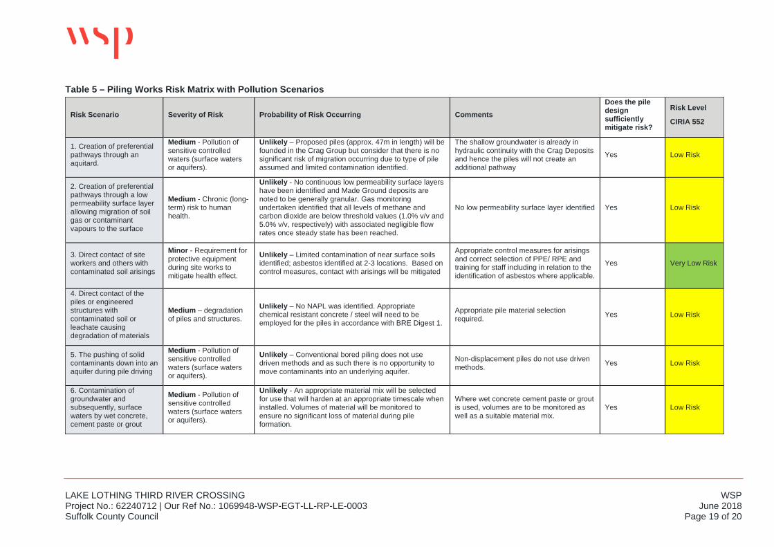
Table 5 – Piling Works Risk Matrix with Pollution Scenarios
Risk Scenario Severity of Risk Probability of Risk Occurring Comments Does the pile design sufficiently mitigate risk?
Risk Level
CIRIA 552
1. Creation of preferential pathways through an aquitard.
Medium - Pollution of sensitive controlled waters (surface waters or aquifers).
Unlikely – Proposed piles (approx. 47m in length) will be founded in the Crag Group but consider that there is no significant risk of migration occurring due to type of pile assumed and limited contamination identified.
The shallow groundwater is already in hydraulic continuity with the Crag Deposits and hence the piles will not create an additional pathway
Yes Low Risk
2. Creation of preferential pathways through a low permeability surface layer allowing migration of soil gas or contaminant vapours to the surface
Medium - Chronic (long-term) risk to human health.
Unlikely - No continuous low permeability surface layers have been identified and Made Ground deposits are noted to be generally granular. Gas monitoring undertaken identified that all levels of methane and carbon dioxide are below threshold values (1.0% v/v and 5.0% v/v, respectively) with associated negligible flow rates once steady state has been reached.
No low permeability surface layer identified Yes Low Risk
3. Direct contact of site workers and others with contaminated soil arisings
Minor - Requirement for protective equipment during site works to mitigate health effect.
Unlikely – Limited contamination of near surface soils identified; asbestos identified at 2-3 locations. Based on control measures, contact with arisings will be mitigated
Appropriate control measures for arisings and correct selection of PPE/ RPE and training for staff including in relation to the identification of asbestos where applicable.
Yes Very Low Risk
4. Direct contact of the piles or engineered structures with contaminated soil or leachate causing degradation of materials
Medium – degradation of piles and structures.
Unlikely – No NAPL was identified. Appropriate chemical resistant concrete / steel will need to be employed for the piles in accordance with BRE Digest 1.
Appropriate pile material selection required. Yes Low Risk
5. The pushing of solid contaminants down into an aquifer during pile driving
Medium - Pollution of sensitive controlled waters (surface waters or aquifers).
Unlikely – Conventional bored piling does not use driven methods and as such there is no opportunity to move contaminants into an underlying aquifer.
Non-displacement piles do not use driven methods. Yes Low Risk
6. Contamination of groundwater and subsequently, surface waters by wet concrete, cement paste or grout
Medium - Pollution of sensitive controlled waters (surface waters or aquifers).
Unlikely - An appropriate material mix will be selected for use that will harden at an appropriate timescale when installed. Volumes of material will be monitored to ensure no significant loss of material during pile formation.
Where wet concrete cement paste or grout is used, volumes are to be monitored as well as a suitable material mix.
Yes Low Risk
WSP LAKE LOTHING THIRD RIVER CROSSING June 2018 Project No.: 62240712 | Our Ref No.: 1069948-WSP-EGT-LL-RP-LE-0003 Page 20 of 20 Suffolk County Council
6 CONCLUSIONS AND RECOMMENDATIONS
6.1 CONCLUSIONS Due to the inherently variable nature of the Made Ground and the soft, compressible, near surface soils, bored piles founded in the Crag Group are considered the most appropriate solution. Limited contamination has been identified from analysis of soils, leachate and groundwater results (mainly in the near surface soils) but it is noted that the near surface soils are in hydraulic continuity with the Principal Aquifer (Crag Group) at depth so the use of piles will not create additional pathways for migration of any contamination present.
Pile arisings potentially introduce a risk of exposure to soil contamination at the surface, and consideration should be given to protecting construction workers during the piling activities. Mitigation measures will be required to alleviate these risks, including (but not limited to) dust suppression and the wearing of appropriate PPE/RPE. This will be the responsibility of the piling contractor and managed accordingly.
Conventional bored piles would use concrete, cement paste or grout and hence contamination of groundwater and surface waters could arise if the site works are not properly managed. Consideration to pile material will be given during detailed design and appropriate materials selected for use that will harden within an appropriate timescale when installed. In addition, volumes of piling concrete need to be monitored to ensure that there is no significant loss of material during pile formation.
On review of the site data, the proposed piling works are considered not to represent a significant risk to local controlled waters or human health receptors. A risk assessment adopting the approach in UK CIRIA Report C552 (Contaminated Land Risk Assessment: A Guide to Good Practice, 2001) assesses the risk to be LOW.
6.2 RECOMMENDATIONS On the basis of this assessment, the following recommendations are made:
An appropriate pile material mix should be selected for use that will harden within an appropriate timescale when installed. Volumes of piling concrete should be monitored to ensure no significant loss of material during pile formation.
Due to limited soil contamination (predominantly in the near surface soils and groundwater), appropriate dust suppression measures should be undertaken and site workers should wear suitable PPE/ RPE
Quality Assurance and Quality Control (QA/QC) measures should be identified and adopted prior to piling works being undertaken. These are primarily for construction quality and structural performance. However, they are also equally relevant to mitigate environmental risk. The relevant measures should ensure that the foundation pile solution techniques are carried out correctly and in an appropriate manner so that the risk assessment and conclusions remain valid. Such QA/QC procedures will normally be agreed between the contractor, client, and relevant regulators.
Further groundwater monitoring from borehole installations should be undertaken to confirm that no significant exceedences of the groundwater screening values are occurring.

Appendix A DRAWINGS
DRAWING STATUS
DRAWN
SCALE @ A3 SIZE
DRAWING NUMBER
CHECKED APPROVED AUTHORISED SUITABILITY
DATE REVISION
Project Originator Volume
Location Type Role Number
DRAWING TITLE
PROJECT TITLE
DESCRIPTION
REVISION DRAWN CHECKED APPROVED DATE
Mapping reproduced by permission of Ordnance Survey on behalf of HMSO.© Crown copyright and database rights 2017. All rightsreserved.Ordnance Survey licence number 100023395Contains OS data © Crown copyright and database rights2017.
?
?
?
?
??
?
???
?
?
?
?
³
³
³
³
³
³
³
³³
³
³
³
³
³
³³
§
§
§
§§
§
§
§
§
§
§
§
§
§
§
§
±
±
±
±
±
±
±
±±
±
±
±
±
±
±±
E
E
E
D
D
D
!
!
!
!
!
! !
!!
!!
!
!
!
!
!
!
C
C
C
C
C
C C
CC
CC
C
C
C
C
C
C
A
AA A
A AAAA
A
AA
A A
A
A A
A
A
AA
AA
A
A
A
A
AA
A
WSC28
WSC23
WSC22
WSC21
WSC19
WSC17
WSC16
WSC14
TPC23
TPC22
TPC21
TPC10
TPC09
TPC08
TPC07
TPC06
TPC05TPC04
TPC03
TPC02
TPC01
CBR18
CBR17
CBR14
BHC32
BHC28
BHC27
BHC26
BHC24
BHC23
BHC22
BHC20
BHC19
BHC18
BHC17
BHC15
BHC14
BHC13
BHC12
BHC10
BHC09
BHC08
BHC07
BHC06BHC05
BHC04BHC03
BHC02
BHC01
WSC16A
TPC103
TPC102
TPC101
CPTC15
CPTC14
CPTC12
CPTC08CPTC07
CPTC06
CPTC05
CPTC04
CPTC03
CPTC02
BHC103
BHC102
BHC101
BHC06BBHC06A
CPTC01A
WSC05
WSC19A
WSC103
WSC101
CPTC20
CPTC18
CPTC13
CPTC10
CPTC09
WSC19A1
CPTC08A
1069948-WSP-EGN-LL-SK-LE-0020
´0 30 60 90 120 150 m
Document Path: W:\ENVADMIN\Hydradmin\GIS_Projects_External\Lake_Lothing\Phase_III_GIS_Figures\Ver_P0\Figure 12_2 1069948-WSP-EGN-LL-SK-LE-0020 P00.mxd
SCALE BAR
1:3,000 (A3)
18/06/2018 P00
IW HR HR JB S4
FOR DCO SUBMISSION
Sampling LocationsRegulation 5(2)(a)
Figure 12.2
FOR DCO SUBMISSION
P00 IW HR MD 18/06/2018
1:3,000
KEY
The Scheme (illustrative)
Existing Rail Track
Order Limits
GI Sampling Locations
A Borehole
!C Cone Penetration Test
ED California Bearing Ratio
³§ ± Trial Pit
? Window Sample

WSP LAKE LOTHING THIRD RIVER CROSSING June 2018 Project No.: 62240712 | Our Ref No.: 1069948-WSP-EGT-LL-RP-LE-0003 Suffolk County Council

Appendix B RISK DESCRIPTORS
WSP LAKE LOTHING THIRD RIVER CROSSING June 2018 Project No.: 62240712 | Our Ref No.: 1069948-WSP-EGT-LL-RP-LE-0003 Suffolk County Council
The identification of potential “pollutant linkages” is a key aspect of the evaluation of potentially contaminated land. An approach based on the UK CIRIA report C552 (Contaminated Land Risk Assessment: A Guide to Good Practice, 2001) has been adopted within this report. For each of the pollutant linkages, an estimate is made of:
The potential severity of the risk; and
The likelihood of the risk occurring.
Table B-1 presents the classification of the severity of the risk:
Table B-1: Severity of Risk
Severe Acute risks to human health;
Major pollution of controlled waters (watercourses or groundwater)
Medium Chronic (long-term) risk to human health;
Pollution of sensitive controlled waters (surface waters or aquifers)
Mild Pollution of non-sensitive water resources.
Minor Requirement for protective equipment during site works to mitigate health effects;
Damage to non-sensitive ecosystems or species
The probability of the risk occurring is classified by criteria given in Table B-2.
Table B-2: Probability of Risk Occurring
High Likelihood
Pollutant linkage may be present, and risk is almost certain to occur in the long term, or there is evidence of harm to the receptor.
Likely Pollutant linkage may be present, and it is probable that the risk will occur over the long term.
Low Likelihood
Pollutant linkage may be present and there is a possibility of the risk occurring, although there is no certainty that it will do so.
Unlikely Pollutant linkage may be present but the circumstances under which harm would occur are improbable.
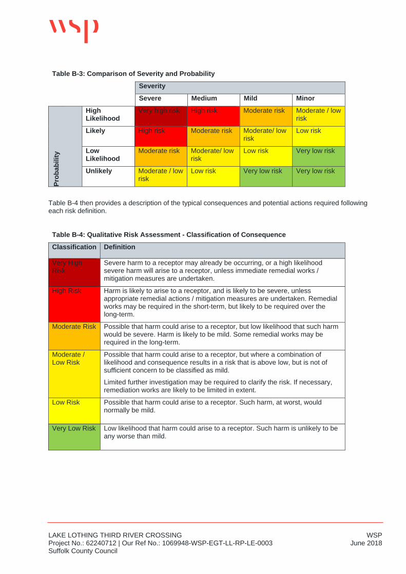
An overall evaluation of the level of risk is gained from a comparison of the severity and probability as presented in Table B-3
LAKE LOTHING THIRD RIVER CROSSING WSP Project No.: 62240712 | Our Ref No.: 1069948-WSP-EGT-LL-RP-LE-0003 June 2018 Suffolk County Council
Table B-3: Comparison of Severity and Probability
Severity
Severe Medium Mild Minor
Prob
abili
ty
High Likelihood
Very high risk High risk Moderate risk Moderate / low risk
Likely High risk Moderate risk Moderate/ low risk
Low risk
Low Likelihood
Moderate risk Moderate/ low risk
Low risk Very low risk
Unlikely Moderate / low risk
Low risk Very low risk Very low risk
Table B-4 then provides a description of the typical consequences and potential actions required following each risk definition.
Table B-4: Qualitative Risk Assessment - Classification of Consequence
Classification Definition
Very High Risk
Severe harm to a receptor may already be occurring, or a high likelihood severe harm will arise to a receptor, unless immediate remedial works / mitigation measures are undertaken.
High Risk Harm is likely to arise to a receptor, and is likely to be severe, unless appropriate remedial actions / mitigation measures are undertaken. Remedial works may be required in the short-term, but likely to be required over the long-term.
Moderate Risk Possible that harm could arise to a receptor, but low likelihood that such harm would be severe. Harm is likely to be mild. Some remedial works may be required in the long-term.
Moderate / Low Risk
Possible that harm could arise to a receptor, but where a combination of likelihood and consequence results in a risk that is above low, but is not of sufficient concern to be classified as mild.
Limited further investigation may be required to clarify the risk. If necessary, remediation works are likely to be limited in extent.
Low Risk Possible that harm could arise to a receptor. Such harm, at worst, would normally be mild.
Very Low Risk Low likelihood that harm could arise to a receptor. Such harm is unlikely to be any worse than mild.

1st Floor Station House Tithebarn Street, Exchange Station Liverpool L2 2QP wsp.com


![The Lake Lothing (Lowestoft) Third Crossing Order 201[*] · Document Reference: 5.1 The Lake Lothing (Lowestoft) ... authorise the construction, operation and maintenance of a new](https://img.pdfslide.net/doc/110x75/5fd6fc09bbb3fd3e712db104/the-lake-lothing-lowestoft-third-crossing-order-201-document-reference-51.jpg)