Embed Size (px)
Citation preview

Planning and Development Committee
Date: September 21, 2020Time: 6:00 PMLocation: Council Chambers, Civic Centre, 2nd Floor
300 City Centre Drive, Mississauga, Ontario, L5B 3C1And Online Video Conference
MembersMayor Bonnie CrombieCouncillor Stephen Dasko Ward 1Councillor Karen Ras Ward 2Councillor Chris Fonseca Ward 3Councillor John Kovac Ward 4Councillor Ron Starr Ward 6Councillor Dipika Damerla Ward 7Councillor Matt Mahoney Ward 8Councillor Sue McFadden Ward 10Councillor George Carlson Ward 11 (Chair)Councillor Carolyn Parrish Ward 5 (ex-officio)Councillor Pat Saito Ward 9 (ex-officio)
Participate Virtually and In PersonAdvance registration is required to participate in person and/or make comment in the virtual public meeting.Please email [email protected] no later than Friday, September 18, 2020 at 4:00p.m. Any materials you wish to show the Committee during your presentation must be provided as anattachment to the email. Links to cloud services will not be accepted. You will be provided with directions onhow to participate from Clerks' staff.
Participate Via TelephoneResidents without access to the internet, via computer, smartphone or tablet, can participate and/or makecomment in the meeting via telephone. To register, please call Angie Melo at 905-615-3200 ext. 5423 nolater than Friday, September 18, 2020 at 4:00 p.m. You must provide your name, phone number, andapplication number if you wish to speak to the Committee. You will be provided with directions on how toparticipate from Clerks' staff.
Contact:Angie Melo, Legislative Coordinator, Legislative Services905-615-3200 ext. [email protected]

PUBLIC MEETING STATEMENT: In accordance with the Ontario Planning Act, if you do not make averbal submission to the Committee or Council, or make a written submission prior to City Council makinga decision on the proposal, you will not be entitled to appeal the decision of the City of Mississauga to theLocal Planning and Appeal Tribunal (LPAT), and may not be added as a party to the hearing of an appealbefore the LPAT.
Send written submissions or request notification of future meetings to:Mississauga City Council Att: Development Assistantc/o Planning and Building Department – 6th Floor300 City Centre Drive, Mississauga, ON, L5B 3C1Or Email: [email protected]
Planning and Development Committee 2020/09/21

1. CALL TO ORDER
2. DECLARATION OF CONFLICT OF INTEREST
3. MINUTES OF PREVIOUS MEETING
Planning and Development Committee Meeting Minutes - September 8, 2020
4. MATTERS TO BE CONSIDERED
4.1 PUBLIC MEETING INFORMATION REPORT (WARD 1)
Draft Plan of Subdivision, Official Plan amendment and Rezoning applications to permit amixed use waterfront community with employment, commercial, institutional, cultural, parkuses and 8,050 residential units1082 Lakeshore Road East and 800 Hydro Road, south side of Lakeshore Road East, eastof Lakefront PromenadeOwner: Lakeview Community Partners LimitedFiles: OZ 19/003 W1, OZ 19/021 W1 and T-M19001 W1
5. ADJOURNMENT
Planning and Development Committee 2020/09/21

Subject PUBLIC MEETING INFORMATION REPORT (WARD 1)
Draft Plan of Subdivision, Official Plan amendment and Rezoning applications to permit a
mixed use waterfront community with employment, commercial, institutional, cultural,
park uses and 8,050 residential units
1082 Lakeshore Road East and 800 Hydro Road, south side of Lakeshore Road East, east
of Lakefront Promenade
Owner: Lakeview Community Partners Limited
Files: OZ 19/003 W1, OZ 19/021 W1 and T-M19001 W1
Recommendation That the report dated August 28, 2020, from the Commissioner of Planning and Building
regarding the applications by Lakeview Community Partners Limited to permit a mixed-use
waterfront community, under Files OZ 19/003 W1, OZ 19/021 W1 and T-M19001 W1,
1082 Lakeshore Road East and 800 Hydro Road, be received for information.
Report Highlights This report has been prepared for a public meeting to hear from the community
The proposal seeks a plan of subdivision and amendments to the Official Plan and
Zoning By-law to permit 8,050 residential units distributed amongst taller, mid-rise and
townhome units as well as park, commercial, employment, institutional and cultural uses
Community concerns identified to date relate to built form, density, parking,
environmental implications, traffic, adequacy of services and waterfront accessibility
Prior to the next report, matters to be addressed include: built form design, proposed
zoning regulations, affordable housing, parks depot location, school accommodation,
district energy and vacuum waste, and the satisfactory resolution of other technical
Date: August 28, 2020 To: Chair and Members of Planning and Development
Committee From: Andrew Whittemore, M.U.R.P., Commissioner of
Planning & Building
Originator’s files: OZ 19/003 W1 OZ 19/021 W1 & T-M19001 W1
Meeting date: September 21, 2020
4.1.
Planning and Development Committee
2020/08/28 2
Originator’s files: OZ 19/003 W1, OZ 19/021 W1 & T-M19001 W1
4.1.
requirements and studies related to the project
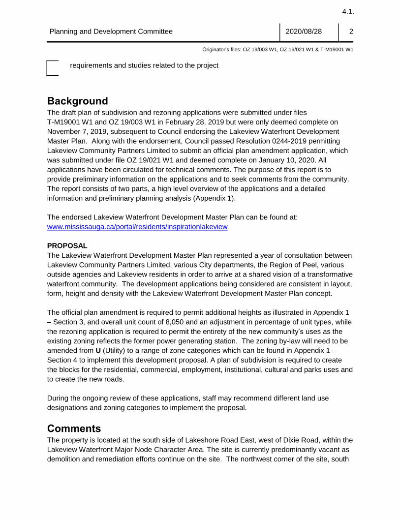
Background The draft plan of subdivision and rezoning applications were submitted under files
T-M19001 W1 and OZ 19/003 W1 in February 28, 2019 but were only deemed complete on
November 7, 2019, subsequent to Council endorsing the Lakeview Waterfront Development
Master Plan. Along with the endorsement, Council passed Resolution 0244-2019 permitting
Lakeview Community Partners Limited to submit an official plan amendment application, which
was submitted under file OZ 19/021 W1 and deemed complete on January 10, 2020. All
applications have been circulated for technical comments. The purpose of this report is to
provide preliminary information on the applications and to seek comments from the community.
The report consists of two parts, a high level overview of the applications and a detailed
information and preliminary planning analysis (Appendix 1).
The endorsed Lakeview Waterfront Development Master Plan can be found at:
www.mississauga.ca/portal/residents/inspirationlakeview
PROPOSAL
The Lakeview Waterfront Development Master Plan represented a year of consultation between
Lakeview Community Partners Limited, various City departments, the Region of Peel, various
outside agencies and Lakeview residents in order to arrive at a shared vision of a transformative
waterfront community. The development applications being considered are consistent in layout,
form, height and density with the Lakeview Waterfront Development Master Plan concept.
The official plan amendment is required to permit additional heights as illustrated in Appendix 1
– Section 3, and overall unit count of 8,050 and an adjustment in percentage of unit types, while
the rezoning application is required to permit the entirety of the new community’s uses as the
existing zoning reflects the former power generating station. The zoning by-law will need to be
amended from U (Utility) to a range of zone categories which can be found in Appendix 1 –
Section 4 to implement this development proposal. A plan of subdivision is required to create
the blocks for the residential, commercial, employment, institutional, cultural and parks uses and
to create the new roads.
During the ongoing review of these applications, staff may recommend different land use
designations and zoning categories to implement the proposal.
Comments The property is located at the south side of Lakeshore Road East, west of Dixie Road, within the
Lakeview Waterfront Major Node Character Area. The site is currently predominantly vacant as
demolition and remediation efforts continue on the site. The northwest corner of the site, south

Planning and Development Committee
2020/08/28 3
Originator’s files: OZ 19/003 W1, OZ 19/021 W1 & T-M19001 W1
4.1.
of Rangeview Road, contains baseball diamonds and a soccer field which will be removed in the
fall of 2020.
Aerial image of 1082 Lakeshore Road East
Applicant’s rendering of the proposed waterfront community
Planning and Development Committee
2020/08/28 4
Originator’s files: OZ 19/003 W1, OZ 19/021 W1 & T-M19001 W1
4.1.
LAND USE POLICIES AND REGULATIONS
The Planning Act allows any person within the Province of Ontario to submit development
applications to the local municipality to build or change the use of any property. Upon submitting
all required technical information, the municipality is obligated under the Planning Act to process
and consider these applications within the rules set out in the Act.
The Provincial Policy Statement (PPS) establishes the overall policy directions on matters of
provincial interest related to land use planning and development within Ontario. It sets out
province-wide direction on matters related to the efficient use and management of land and
infrastructure; the provision of housing; the protection of the environment, resources and water;
and, economic development.
The Growth Plan for the Greater Golden Horseshoe (Growth Plan) builds upon the policy
framework established by the PPS and provides more specific land use planning policies which
support the achievement of complete communities, a thriving economy, a clean and healthy
environment and social equity. The Growth Plan establishes minimum intensification targets and
requires municipalities to direct growth to existing built-up areas and strategic growth areas to
make efficient use of land, infrastructure and transit.
The Planning Act requires that municipalities’ decisions regarding planning matters be
consistent with the PPS and conform with the applicable provincial plans and the Region of Peel
Official Plan (ROP). Mississauga Official Plan is generally consistent with the PPS and
conforms with the Growth Plan, the Greenbelt Plan, the Parkway Belt West Plan and the ROP.
Conformity of this proposal with the policies of Mississauga Official Plan is under review.
Additional information and details are found in Appendix 1, Section 5.
AGENCY AND CITY DEPARTMENT COMMENTS
Agency and department comments are summarized in Appendix 1, Section 8.
Additional Community Elements The visioning and planning of a new waterfront community has included a number of community
elements, as well as challenges, which fall beyond the regular scope of a typical development
application. These include, but are not limited to:
1. District Energy – Lakeview Community Partners Limited have retained the services of Corix
Utilities in order to evaluate the environmental benefits as well as the technical and financial
feasibility of a district energy system based on the thermal energy produced at the G.E.
Booth wastewater treatment facility. They have been working closely with the Region of
Peel to evaluate its feasibility and ownership model. Implementation will require Regional
endorsement and government funding beyond municipal resources. A district energy facility

Planning and Development Committee
2020/08/28 5
Originator’s files: OZ 19/003 W1, OZ 19/021 W1 & T-M19001 W1
4.1.
is proposed to be located within the Innovation Corridor on City owned lands. While district
energy is being pursued as part of the proposal, the timing for commitments for funding may
not align with the endorsement of the development applications. Council may wish to
consider approval without the securement of the district energy system.
2. Vacuum Waste – Lakeview Community Partners Limited have been working with Envac and
the Region of Peel to explore the technical and financial feasibility of incorporating a vacuum
waste system into the new community. Vacuum waste would replace traditional curbside
waste, recycling and organics pick-up. Implementation will require Regional endorsement
and government funding beyond municipal resources. A vacuum waste collection facility is
proposed to be co-located within the district energy building. Like district energy, the timing
for commitments for funding may not align with the endorsement of the development
applications. Council may wish to consider approval without the securement of the vacuum
waste system.
3. Waterfront Park Development – The waterfront parks illustrated represent an enhanced
level of park features and services and would be a regional draw. Park development is
funded through development charges. Further review is required to reconcile the
anticipated development charge funding, projected operating costs and the proposed level
of enhanced parks.
4. Artscape – The City has been having ongoing discussions with Lakeview Community
Partners Limited and Artscape in order to test pilot an atelier model whereby artists are
commissioned to create works that are incorporated into the community. Should the test
pilot prove successful it is envisioned that Artscape artists could potentially have permanent
studio space and residences within the community. Artscape is seeking to partner with the
City in establishing the pilot project which could last a few years. If successful, such a
program would be transformative to the community, however, given the long term nature of
such an endeavour, any commitments or agreements may fall outside of the development
application process.
5. Affordable Housing – The programming for affordable housing has not yet been indicated.
In accordance with City and Regional targets, the City is requesting that a minimum of 10%
of new units be affordable.
6. Parks Depot Relocation - The submitted draft plan of subdivision illustrates a realigned
Lakefront Promenade Road. The realignment conflicts with the existing Parks Depot located
within Lakefront Promenade Park. Lakeview Community Partners Limited have committed
to the construction of a new parks depot at an alternate location. Satisfactory new locations
are being investigated but have not yet been finalised.
7. Architectural Competition - As established through the endorsement of the Development
Master Plan, architectural competitions will be required for the Marina District and for the

Planning and Development Committee
2020/08/28 6
Originator’s files: OZ 19/003 W1, OZ 19/021 W1 & T-M19001 W1
4.1.
22-storey building at the terminus of Waterway Common. The competitions will be further
outlined through agreements associated with the subdivision.
Financial Impact All fees paid by developers are strictly governed by legislation, regulation and City by-laws.
Fees are required to be paid prior to application approval, except where otherwise may be
prescribed. These include those due to the City of Mississauga as well as any other external
agency.
Conclusion Most agency and City department comments have been received but are being updated based
on recent resubmissions. The Planning and Building Department will make a recommendation
on this project after the public meeting has been held and the issues have been resolved. The
matters to be addressed include, but are not limited to: urban design guidelines, sustainability
features and commitments, review of reduced parking standards and provision of additional
technical information
Attachments Appendix 1: Detailed Information and Preliminary Planning Analysis
Andrew Whittemore, M.U.R.P., Commissioner of Planning & Building
Prepared by: David Breveglieri, Development Planner
Appendix 1, Page 1 Files: OZ19/003 W1, OZ 19/021 W1 & T-M19001 W1
4.1.
Detailed Information and Preliminary Planning Analysis
Owner: Lakeview Community Partners
1082 Lakeshore Road East
Table of Contents
1. Site History ................................................................................................................................................................................... 2
2. Site and Neighbourhood Context .................................................................................................................................................. 2
3. Project Details ............................................................................................................................................................................... 5
4. Land Use Policies, Regulations & Amendments.......................................................................................................................... 12
5. Summary of Applicable Policies .................................................................................................................................................. 24
6. School Accommodation .............................................................................................................................................................. 32
7. Community Comments ................................................................................................................................................................ 33
8. Development Issues ................................................................................................................................................................... 33
9. Section 37 Community Benefits (Bonus Zoning) ......................................................................................................................... 40
Appendix 1, Page 2 Files: OZ19/003 W1, OZ 19/021 W1 & T-M19001 W1
4.1.
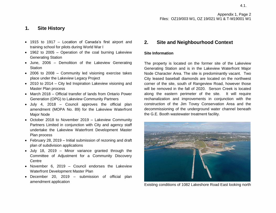
1. Site History
1915 to 1917 – Location of Canada’s first airport and
training school for pilots during World War I
1962 to 2005 – Operation of the coal burning Lakeview
Generating Station
June, 2006 – Demolition of the Lakeview Generating
Station
2006 to 2008 – Community led visioning exercise takes
place under the Lakeview Legacy Project
2010 to 2014 – City led Inspiration Lakeview visioning and
Master Plan process
March 2018 – Official transfer of lands from Ontario Power
Generation (OPG) to Lakeview Community Partners
July 4, 2018 – Council approves the official plan
amendment (MOPA No. 89) for the Lakeview Waterfront
Major Node
October 2018 to November 2019 – Lakeview Community
Partners Limited in conjunction with City and agency staff
undertake the Lakeview Waterfront Development Master
Plan process
February 28, 2019 – Initial submission of rezoning and draft
plan of subdivision applications
July 18, 2019 – Minor variance granted through the
Committee of Adjustment for a Community Discovery
Centre
November 6, 2019 – Council endorses the Lakeview
Waterfront Development Master Plan
December 20, 2019 – submission of official plan
amendment application
2. Site and Neighbourhood Context
Site Information
The property is located on the former site of the Lakeview
Generating Station and is in the Lakeview Waterfront Major
Node Character Area. The site is predominantly vacant. Two
City leased baseball diamonds are located on the northwest
corner of the site, south of Rangeview Road, however those
will be removed in the fall of 2020. Serson Creek is located
along the eastern perimeter of the site. It will require
rechanalization and improvements in conjunction with the
construction of the Jim Tovey Conservation Area and the
decommissioning of the underground water channel beneath
the G.E. Booth wastewater treatment facility.
Existing conditions of 1082 Lakeshore Road East looking north

Appendix 1, Page 3 Files: OZ19/003 W1, OZ 19/021 W1 & T-M19001 W1
4.1.
Property Size and Use
Frontages: 135 m (443 ft.) along Lakeshore Road East
Depth: 1 km (3,280 ft.) excluding pier
Gross Lot Area: 71.6 ha ( 177 ac.)
Existing Uses: Baseball diamonds on the northwest corner, balance is vacant
Surrounding Land Uses
The majority of the parcel is located south of the employment
area known as Rangeview Estates. It is bordered on the west
side by Lakefront Promenade Park and Douglas Kennedy
Park which both contain active sports fields as well as a City
parks depot. Abutting the site to the east is the Region of
Peel’s G.E. Booth wastewater treatment facility
The surrounding land uses are:
North: Rangeview Estates employment uses
East: Regional wastewater treatment facility
South: Lake Ontario
West: Lakefront Promenade Park, Douglas Kennedy Park
Aerial Photo of 1082 Lakeshore Road East and
800 Hydro Road
The Neighbourhood Context Given the site’s previous use it is well separated from existing
residential uses. The closest homes are located north of
Lakeshore Road East behind the mainstreet commercial uses
that currently exist along the road. The closest dwellings to the
west are located over 500 m (1,640 ft.) away, beyond
Lakefront Promenade Park and the Region of Peel’s water
treatment facility. The Rangeview Estates employment area
abutting the site to the north consists predominantly of older
one-storey industrial buildings built in the 1960’s. Given the
Lakeview Waterfront Major Node policies, it is anticipated that
this area will transition to residential in the future. The G.E.
Booth wastewater treatment facility abutting the site to the

Appendix 1, Page 4 Files: OZ19/003 W1, OZ 19/021 W1 & T-M19001 W1
4.1.
west is one of the largest of such facilities in Ontario and
serves 800,000 residents. It contains three separate plants
the oldest of which is scheduled to be replaced in 2026.
Demographics
Based on the 2016 census, the existing population of the
Lakeview Neighbourhood area is 21,520 with a median age of
this area being 45 (compared to the City’s median age of 40).
67% of the neighbourhood population are of working age (15
to 64 years of age), with 14% children (0-14 years) and 18%
seniors (65 years and over). The average household size is 2
persons with 32% of people living in apartments in buildings
that are five storeys or more. The mix of housing tenure for the
area is 6,395 units (72%) owned and 2,440 units (28%) rented
with a vacancy rate of approximately 0.8%*. The number of
jobs within the Lakeview Neighbourhood area is 3,010 while
the number of jobs within Lakeview Employment area (ie.
Rangeview Estates) is 1,785.
Other Development Applications
A site plan application for a Discovery Centre associated with
the new Lakeview Village community has been submitted
under file SP 18/108 W1 and is currently under review by staff.
It is anticipated that approval may be granted this spring.
Community and Transportation Services
In addition to the parks proposed through the development,
the site is serviced by Douglas Kennedy Park, Lakefront
Promenade Park, Marie Curtis Park and the future Jim Tovey
Conservation Area. Lakeview Library is located approximately
700 m (2,296 ft.) from the northern edge of the site.
The proposal is being considered in conjunction with the
recommendations contained in the Lakeshore Connecting
Communities Transportation Master Plan. Transit investments
include increased local service and a new Lakeshore
MiExpress route in the first phase with upgrades to centre
median bus lanes in the future. Two major transit stops have
been identified which would service this development;
Lakeshore Road and Lakefront Promenade Road and
Lakeshore Road and Haig Boulevard.
The following major MiWay bus routes currently service the
site:
Route 23 – Lakeshore Road East
Route 5 – Lakeshore Road East Both Route 5 and 23 connect to the Long Branch GO Station
which is located 1 km (0.6 mi) to the east. It provides all day
rail service and is the west terminus of the TTC streetcar route.
Route 5 travels in a north-south direction and also connects to
the Dixie GO Station.
Mississauga’s Waterfront Trail runs across the northern edge
of the site, following Hydro Road northward and continuing
eastward along Lakeshore Road. Through this development,
it is planned to have the Waterfront Trail realigned along the
waterfront and connect eastward through the new Jim Tovey
Conservation Area. There are two bike routes that run north
from the site; an on-road signed bike route on Ogden Avenue
and a designated bike lane on Dixie Road.

Appendix 1, Page 5 Files: OZ19/003 W1, OZ 19/021 W1 & T-M19001 W1
4.1.
3. Project Details
The applications are to amend the official plan and zoning
by-law and approve a plan of subdivision to permit a new
mixed-use waterfront community with 8,050 residential units
consisting of apartment and townhouse units, approximately
11 acres of employment land, known as the Innovation
Corridor on the eastern portion of the property, 147,000 ft2 of
commercial space most of which will be centered around a
village square, cultural and park uses. A dedication of 67 acres
of waterfront land has been committed to by Lakeview
Community Partners Limited. A preliminary delineation of
these lands is illustrated in the Conveyance Plan.
Development Proposal
Applications submitted:
Received: February 28, 2019 (Subdivision and Rezoning) December 20, 2019 (Official Plan Amendment) Deemed complete: November 7 2019 (Subdivision and Rezoning) Jan 10, 2020 (Official Plan Amendment
Developer/ Owner:
Lakeview Community Partners Limited
Applicant: Glen Schnarr and Associates
Number of units: 8,050 units
Existing Gross Floor Area:
NIL
Proposed Gross Floor Area:
16 850 m2 (181,376 ft2) - commercial 162 900 m2 (1,753,498 ft2) - Office/Institutional
Height: Range of 4 - 40 storeys
Development Proposal
Parkland Area: 14.5 ha (35.8 ac)
Net Density: 334 units/ha (135 units/ac) – based on net residentially designated land
Road Type: Combination of public and condominium private roads
Anticipated Population:
17,874* *Average household sizes for all units (by type) based on the 2016 Census
Anticipated population plus jobs (PPJ)
Approx. 397 per hectare (161 per acre) *Based on a 2:1 people to employment ratio
Parking:
resident spaces visitor spaces Anticipated total residential parking
Required
1.25 per 1-bedroom unit 1.4 per 2-bedroom unit 1.75 per 3- bedroom unit 2 per townhome 0.25 visitor spaces per unit
Provided
1.0 per all condominium apartment units 1.4 per townhome 0.15 visitor spaces per unit 9,409 parking spaces *More detailed parking rates found in section 4
Green Initiatives: proposed district energy
proposed vacuum waste system
proposed bioswales
proposed rainwater cisterns
proposed green roofs
proposed solar panels for employment area

Appendix 1, Page 6 Files: OZ19/003 W1, OZ 19/021 W1 & T-M19001 W1
4.1.
Supporting Studies and Plans
The applicant has submitted the following information in
support of the applications which can be viewed at
http://www.mississauga.ca/lakeview-waterfront
• Planning Justification Report
• Serson Creek Design Brief
• Intersection Design Report
• Shadow and Wind Study
• Archaeological Assessment
• Draft Official Plan and Zoning By-law Amendments
• Functional Servicing Report
• Phase I & II Environmental Report
• Environmental Impact Assessment
• Water Quality and Aquatic Habitat Report
• Preliminary Geotechnical Investigation
• Shoreline Hazard Assessment
• Shoreline Design Life Peer Review
• Outdoor Amenity Area Concept Plan
• Arborist Report
• Affordable Housing Brief
• Air Quality, Noise and Land Use Compatibility Study
• Archeological Assessment
• Heritage Impact Assessment
• Open Space and Park Plan
• Docking Feasibility Study
• Streetscape Feasibility Study
• Phasing, Land Use, Block and Conveyance Plans
• Pedestrian Wind Study
• Urban Design Study
• Retail Analysis

Appendix 1, Page 7 Files: OZ19/003 W1, OZ 19/021 W1 & T-M19001 W1
4.1.
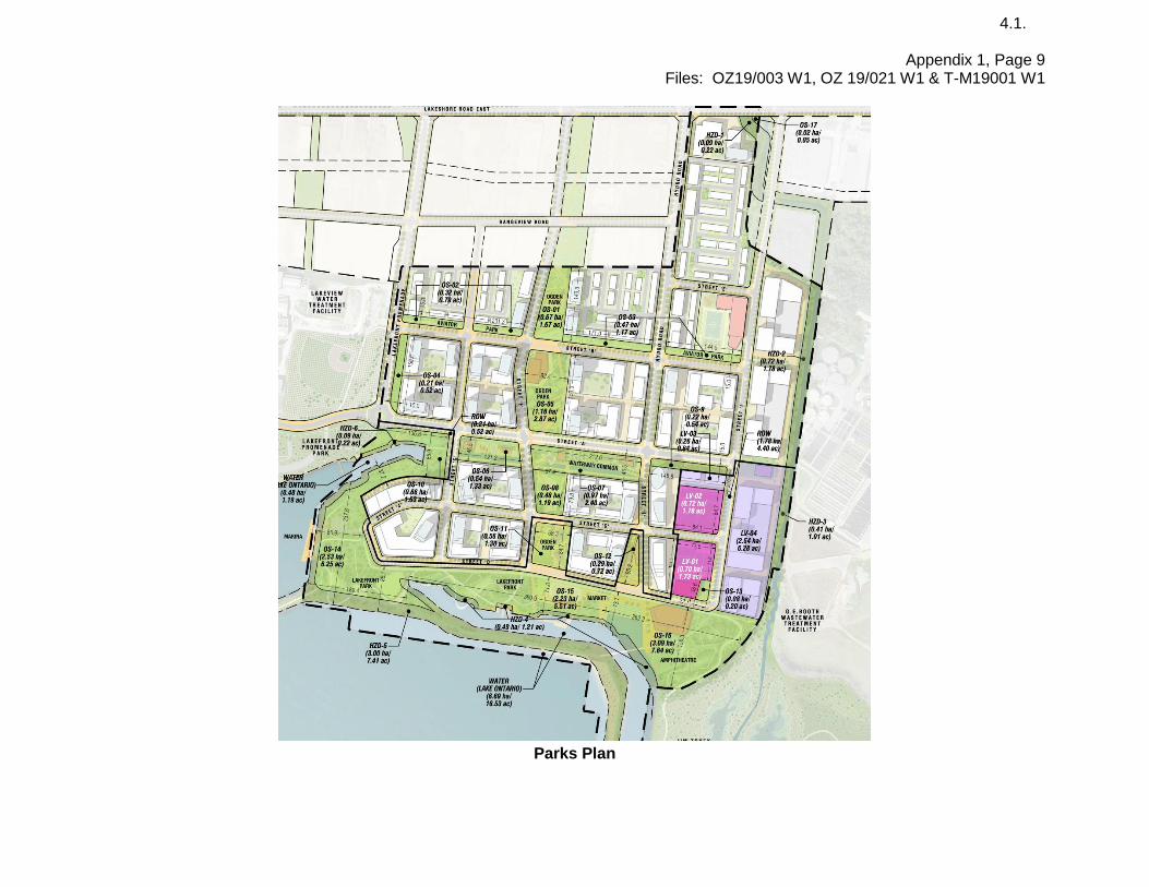
Draft Plan of Subdivision, Conveyance Plan, Parks Plan, Concept Plan and Renderings
Draft Plan of Subdivision

Appendix 1, Page 8 Files: OZ19/003 W1, OZ 19/021 W1 & T-M19001 W1
4.1.
General Conveyance Plan
Appendix 1, Page 9 Files: OZ19/003 W1, OZ 19/021 W1 & T-M19001 W1
4.1.
Parks Plan

Appendix 1, Page 10 Files: OZ19/003 W1, OZ 19/021 W1 & T-M19001 W1
4.1.
Concept Plan with heights

Appendix 1, Page 11 Files: OZ19/003 W1, OZ 19/021 W1 & T-M19001 W1
4.1.
Applicant’s Rendering
Applicant’s Rendering

Appendix 1, Page 12 Files: OZ19/003 W1, OZ 19/021 W1 & T-M19001 W1
4.1.
4. Land Use Policies, Regulations & Amendments
Mississauga Official Plan
Existing Designation The site is designated Residential Medium Density, Mixed Use, Public Open Space, Business Employment, Institutional and Greenlands. The Residential Medium Density designation permits townhomes and apartment buildings of varying heights. The Mixed Use designation permits various commercial uses and residential in conjunction with other permitted uses. The Public Open Space Use designation permits parks. The Business Employment designation permits office, manufacturing and other employment uses. The Institutional designation permits post-secondary schools, office and marine related uses. The Greenlands designation is associated with natural hazards. A portion of the site (lands with cross-hatching) is identified as containing Natural Hazards. Proposed Designation No changes to the above noted designation permissions are proposed. The proposed amendment seeks to expand on height permissions, overall unit count, revise precinct unit targets and acknowledge a refined road and block alignment. Through the processing of the applications, staff may recommend a more appropriate designations to reflect the proposed development in the Recommendation Report. Note: Detailed information regarding relevant Official Plan policies are found in Section 5.
Excerpt of Lakeview Waterfront Major Node

Appendix 1, Page 13 Files: OZ19/003 W1, OZ 19/021 W1 & T-M19001 W1
4.1.
Mississauga Zoning By-law
Existing Zoning The portion of the site proposed for redevelopment is currently zoned U-1 (Utility), which permits a power generating station, water or sewage treatment facility, electric distribution facility and utility buildings. Serson Creek on eastern perimeter of the site is zoned G1 (Greenlands), which permits flood control, stormwater management, erosion management and natural heritage features and areas conservation. Proposed Zoning The applicant is proposing eight zones on the property. The proposed zoning for the residential blocks is RA5 – Exception (Apartments). Three different C4 – Exception (Mainstreet Commercial) zones are proposed for the commercial areas which comprise of the village square, the block abutting the village square on the east side, and the Lakeshore Road frontage. Each has site specific regulations. Public parks intended to have animating uses are proposed to be zoned OS2 – Exception (Open Space) while the more passive open spaces are proposed to be zoned OS2 (Open Space). The proposed zoning for the employment blocks is E2 – Exception (Employment). The proposed zoning for the institutional/cultural area in the southeast corner is I – Exception (Institutional). The Serson Creek channel will remain zoned G1 (Greenlands) and the shoreline is proposed to be zoned G1-Exception (Greenlands) .

Appendix 1, Page 14 Files: OZ19/003 W1, OZ 19/021 W1 & T-M19001 W1
4.1.
Proposed Zoning Regulations
Zone Regulations RA5 Zone Regulations
Proposed RA5-Excpetion Amended Zone Regulations
Permitted Uses Apartment, Long-Term Care, Retirement Building
Additional permitted uses: Townhouse, back-to-back townhouse, stacked townhouse, restaurant, personal service establishment, medical office-restricted, day care, retail store, animal care establishment, financial institution, parking lot
Minimum Floor Space Index (FSI)
1.9 none
Maximum Floor Space Index (FSI)
2.9 none
Maximum Dwelling Units n/a 8,050 units in all zone categories
Maximum Gross Floor Area per storey for each storey above 12 storeys
1 000 m2 (10,764 ft2) none
Maximum Height 25 storeys and 77 m (252 ft.) Height schedule to identify varying heights up to maximum of 40 storeys for the tallest building in the Marina District
Minimum front, rear, interior and exterior side yards - apartments
Varying setbacks from 4.5 m (14.7 ft.) to 15.0 m (49.2 ft.) depending on the height of the portion of the building
none
Minimum landscaped area - apartments
40% 10% for Parcel Blocks 12A, 12B and 15 25% for the balance of lands
Parking – Condominium Apartment
1.0 space per studio unit 1.25 space per 1-bedroom unit
1.40 space per 2-bedroom unit
1.75 space per 3-bedroom unit
0.20 visitor spaces per unit
1.0 space per all units 0.15 visitor space per unit

Appendix 1, Page 15 Files: OZ19/003 W1, OZ 19/021 W1 & T-M19001 W1
4.1.
Zone Regulations RA5 Zone Regulations
Proposed RA5-Excpetion Amended Zone Regulations
Parking – Rental Apartment 1.0 spaces per studio unit 1.18 spaces per 1-bedroom unit
1.36 spaces per 2-bedroom unit
1.50 spaces per 3-bedroom unit
0.20 visitor spaces per unit
1.0 spaces per all units 0.15 visitor spaces per unit
Back to back and stacked townhomes
Not permitted in a RA5 apartment zone. Below standards reflect RM9 and RM10 zones for stacked and back to back townhomes
Proposed to be included in RA5-Exception Zone with standards indicated below
Maximum Height Back to Back – 3 storeys Stacked – 4 storeys
n/a
Minimum Front Yard 7.5 m (24.6 ft.) 3.0 m (9.8 ft.)
Minimum Exterior Side Yard 7.5 m (24.6 ft.) 2.4 m (7.9 ft.)
Minimum Interior Yard 4.5 m (14.7 ft.) 1.2 m (3.9 ft.)
Minimum Rear Yard 7.5 m (24.6 ft.) Back to Back -7.5 m (24.6 ft.) Stacked - 6.0 m (19.7 ft.)
Minimum Landscaped Area Back to Back – 40% Stacked – 40%
Back-to-Back – 6% Stacked – 40%
Parking - Townhouse Condominium townhouse: 2.0 spaces per unit 0.25 visitor space per unit Condominium Back to Back and Stacked townhouse: 1.1 spaces per 1-bedroom unit 1.5 spaces per 2-bedroom unit 1.75 spaces per 3-bedroom unit 2.0 spaces per 4-bedroom unit 0.25 visitor space per unit
1.4 spaces per all units 0.15 visitor space per unit
Appendix 1, Page 16 Files: OZ19/003 W1, OZ 19/021 W1 & T-M19001 W1
4.1.
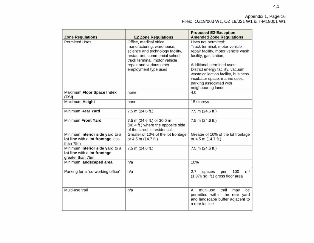
Zone Regulations E2 Zone Regulations
Proposed E2-Exception Amended Zone Regulations
Permitted Uses Office, medical office, manufacturing, warehouse, science and technology facility, restaurant, commercial school, truck terminal, motor vehicle repair and various other employment type uses
Uses not permitted: Truck terminal, motor vehicle repair facility, motor vehicle wash facility, gas station, Additional permitted uses: District energy facility, vacuum waste collection facility, business incubator space, marine uses, parking associated with neighbouring lands
Maximum Floor Space Index (FSI)
none 4.0
Maximum Height none 15 storeys
Minimum Rear Yard 7.5 m (24.6 ft.) 7.5 m (24.6 ft.)
Minimum Front Yard 7.5 m (24.6 ft.) or 30.0 m (98.4 ft.) where the opposite side of the street is residential
7.5 m (24.6 ft.)
Minimum interior side yard to a lot line with a lot frontage less than 75m
Greater of 10% of the lot frontage or 4.5 m (14.7 ft.)
Greater of 10% of the lot frontage or 4.5 m (14.7 ft.)
Minimum interior side yard to a lot line with a lot frontage greater than 75m
7.5 m (24.6 ft.) 7.5 m (24.6 ft.)
Minimum landscaped area n/a 10%
Parking for a “co-working office” n/a 2.7 spaces per 100 m2 (1,076 sq. ft.) gross floor area
Multi-use trail n/a A multi-use trail may be permitted within the rear yard and landscape buffer adjacent to a rear lot line

Appendix 1, Page 17 Files: OZ19/003 W1, OZ 19/021 W1 & T-M19001 W1
4.1.
Zone Regulations I Zone Regulations
Proposed I- Exception Amended Zone Regulations
Permitted Uses University/College and Hospital Additional permitted uses: Science and technology facility, office, commercial school accessory to a university college use, district energy facility, vacuum waste collection facility, cultural facility, marine uses, parking associated with neighbouring lands. Uses not permitted: Hospital
Maximum Height none 15 storeys
Minimum Front Yard 7.5 m (24.6 ft.) 1.5 m (4.9 ft.)
Minimum Rear Yard 7.5 m (24.6 ft.) 7.5 m (24.6 ft.)
Minimum Side Yard setbacks interior 7.5 m (24.6 ft.) exterior 7.5 m (24.6 ft.)
interior 2.5 m (8.2 ft.) exterior 3.0 m (9.8 ft.)
Parking - Office 3.2 spaces per 100 m2 gross floor area
3.2 spaces per 100 m2 (1,076 sq. ft.) gross floor area
Parking for a “co-working office” n/a 2.7 spaces per 100 m2 (1,076 sq. ft.) gross floor area
Multi-use trail n/a A multi-use trail may be permitted within the rear yard and landscape buffer adjacent to a rear lot line
Zone Regulations C4 Zone Regulations
Proposed C4-Exception 1 Amended Zone Regulations
Permitted uses Various commercial uses, office, hotel, apartment and dwelling units located above the first storey of a commercial building
Additional permitted uses: Retirement building, long-term care, parking structure, restaurant patios Uses not permitted: funeral establishment, hotel
Maximum Height 3 storeys 15 storeys 8 storeys for buildings fronting onto Lakeshore Road

Appendix 1, Page 18 Files: OZ19/003 W1, OZ 19/021 W1 & T-M19001 W1
4.1.
Zone Regulations C4 Zone Regulations
Proposed C4-Exception 1 Amended Zone Regulations
Minimum Front Yard 0.0 m (0 ft.) 0.0 m (0 ft.)
Minimum Rear Yard 3.0 m (9.8 ft.) to employment zone
3.0 m (9.8 ft.) to employment zone
Minimum Side Yard setbacks interior – 0 m (0 ft.) to a C4 zone, 4.5 m (14.7 ft.) to a G1 zone exterior – 0 m (0 ft.)
interior – 0.0 m (0 ft.) to a C4 zone, 7.5 m (24.6 ft.) to a G1 zone exterior – 0 m (0 ft.)
Maximum Dwelling Units n/a 8,050 units all zone categories
Minimum setback of a below grade Parking Structure to a Lot Line
n/a 1.0 m (3.3 ft.)
Minimum setback of an above grade Parking Structure to a lot line
n/a 1.0 m (3.3 ft.)
Parking – Condominium Apartment
1.0 spaces per studio unit 1.25 spaces per 1-bedroom unit
1.40 spaces per 2-bedroom unit
1.75 spaces per 3-bedroom unit
0.20 visitor spaces per unit
1.0 spaces per all units 0.15 visitor spaces per unit
Parking – Rental Apartment 2.0 spaces per studio unit 1.18 spaces per 1-bedroom unit
1.36 spaces per 2-bedroom unit
1.50 spaces per 3-bedroom unit
0.20 visitor spaces per unit
1.0 spaces per all units 0.15 visitor spaces per unit
Parking – Retirement Building 0.5 spaces per unit 0.25 visitor spaces per unit
0.4 spaces per unit 0.15 visitor spaces per unit
Parking – Retail store 4.0 spaces per 100 m2
(1,076 sq. ft.) 3.0 spaces per 100 m2
(1,076 sq. ft.)
Parking - Office 3.2 spaces per 100 m2
(1,076 sq. ft.) 3.0 spaces per 100 m2
(1,076 sq. ft.)

Appendix 1, Page 19 Files: OZ19/003 W1, OZ 19/021 W1 & T-M19001 W1
4.1.
Zone Regulations C4 Zone Regulations
Proposed C4-Exception 1 Amended Zone Regulations
Parking - Restaurant 9.0 spaces per 100 m2
(1,076 sq. ft.)
9.0 spaces per 100 m2
(1,076 sq. ft.)
Zone Regulations C4 Zone Regulations
Proposed C4-Exception 2 Amended Zone Regulations
Permitted uses Various commercial uses, office, hotel, apartment and dwelling units located above the first storey of a commercial building
Additional permitted uses: Retirement building, restaurant patios Uses not permitted: funeral establishment, retail store greater than 600 m2 (6,458 sq. ft.)
Maximum Height 3 storeys 12 storeys with the exception one 1 building being permitted 22 storeys
Minimum Front Yard 0 m (0 ft.) 0 m (0 ft.)
Minimum Rear Yard 4.5 m (14.7 ft.) m to a residential zone 4.5 m (14.7 ft.) to an OS zone 0 m (0 ft.) to a C4 zone
4.5 m (14.7 ft.) m to a residential zone 4.5 m (14.7 ft.) to an OS zone 0 m (0 ft.) to a C4 zone
Minimum Side Yard setbacks 4.5m (14.7 ft.) m to a residential zone 4.5 m (14.7 ft.) to an OS zone 0 m (0 ft.) to a C4 zone exterior – 0 m (0 ft.)
4.5 m (14.7 ft.) m to a residential zone 4.5 m (14.7 ft.) to an OS zone 0 m (0 ft.) to a C4 zone exterior – 0 m (0 ft.)
Maximum Dwelling Units n/a 8,050 units all zone categories
Minimum setback of a below grade Parking Structure to a Lot Line
n/a 1.0 m (3.3 ft.)

Appendix 1, Page 20 Files: OZ19/003 W1, OZ 19/021 W1 & T-M19001 W1
4.1.
Zone Regulations C4 Zone Regulations
Proposed C4-Exception 2 Amended Zone Regulations
Minimum setback of an above grade Parking Structure to a Lot Line
n/a 1.0 m (3.3 ft.)
Parking – Condominium Apartment
1.0 spaces per studio unit 1.25 spaces per 1-bedroom unit
1.40 spaces per 2-bedroom unit
1.75 spaces per 3-bedroom unit
0.20 visitor spaces per unit
1.0 spaces per all units 0.15 visitor spaces per unit
Parking – Rental Apartment 1.0 spaces per studio unit 1.18 spaces per 1-bedroom unit
1.36 spaces per 2-bedroom unit
1.50 spaces per 3-bedroom unit
0.20 visitor spaces per unit
1.0 spaces per all units 0.15 visitor spaces per unit
Parking – Retirement Dwelling 0.5 spaces per unit 0.25 visitor spaces per unit
0.4 spaces per unit 0.15 visitor spaces per unit
Parking – Retail Store 4.0 spaces per 100 m2
(1,076 sq. ft.)
1.0 spaces per 100 m2
(1,076 sq. ft.)
Parking - Office 3.2 spaces per 100 m2
(1,076 sq. ft.)
1.0 spaces per 100 m2
(1,076 sq. ft.)
Parking - Restaurant 9.0 spaces per 100 m2
(1,076 sq. ft.)
9.0 spaces per 100 m2
(1,076 sq. ft.)
Zone Regulations C4 Zone Regulations
Proposed C4-Exception 3 Amended Zone Regulations
Permitted uses Various commercial uses, office, hotel, apartment and dwelling
Additional permitted uses: Live/work units, business

Appendix 1, Page 21 Files: OZ19/003 W1, OZ 19/021 W1 & T-M19001 W1
4.1.
Zone Regulations C4 Zone Regulations
Proposed C4-Exception 3 Amended Zone Regulations
units located above the first storey of a commercial building
incubator space, student residence, cultural facilities, passive and active recreational use, parking
Maximum Height 3 storeys 12 storeys
Minimum Font Yard 0.0 m (0 ft.)
0.0 m (0 ft.)
Minimum Rear Yard 4.5 m (14.7 ft.) m to a residential zone 4.5 m (14.7 ft.) to an OS zone 0 m (0 ft.) to a C4 zone
4.5 m (14.7 ft.) m to a residential zone 4.5 m (14.7 ft.) to an OS zone 0 m (0 ft.) to a C4 zone
Minimum Side Yard setbacks 4.5 m (14.7 ft.) m to a residential zone 4.5 m (14.7 ft.) to an OS zone 0 m (0 ft.) to a C4 zone exterior – 0 m (0 ft.)
4.5 m (14.7 ft.) m to a residential zone 4.5 m (14.7 ft.) to an OS zone 0 m (0 ft.) to a C4 zone exterior – 0 m (0 ft.)
Maximum Dwelling Units n/a
8,050 units all zone categories
Minimum setback of a below grade Parking Structure to a Lot Line
3.0 m (9.8 ft.) 1.0 m (3.3 ft.)
Minimum setback of an above grade Parking Structure to a Lot Line
7.5 m (24.6 ft.) 1.0 m (3.3 ft.)
Parking – Condominium Apartment
1.0 spaces per studio unit 1.25 spaces per 1-bedroom unit
1.40 spaces per 2-bedroom unit
1.75 spaces per 3-bedroom unit
0.20 visitor spaces per unit
1.0 spaces per all units 0.15 visitor spaces per unit

Appendix 1, Page 22 Files: OZ19/003 W1, OZ 19/021 W1 & T-M19001 W1
4.1.
Zone Regulations C4 Zone Regulations
Proposed C4-Exception 3 Amended Zone Regulations
Parking – Rental Apartment 1.0 spaces per studio unit 1.18 spaces per 1-bedroom unit
1.36 spaces per 2-bedroom unit
1.50 spaces per 3-bedroom unit
0.20 visitor spaces per unit
1.0 spaces per all units 0.15 visitor spaces per unit
Parking – Retail store 4.0 spaces per 100 m2
(1,076 sq. ft.) 3.0 spaces per 100 m2
(1,076 sq. ft.)
Parking – Office 3.2 spaces per 100 m2
(1,076 sq. ft.) 3.0 spaces per 100 m2
(1,076 sq. ft.)
Parking - Restaurant 9.0 spaces per 100 m2
(1,076 sq. ft.) 9.0 spaces per 100 m2
(1,076 sq. ft.)
Zone OS2 Regulations
Proposed OS2 - Exception Amended Zone Regulations
Permitted Uses Active and passive recreational uses and storm water facilities
Additional permitted uses: Restaurants, retail, cultural facilities, temporary structures, incubator space
Maximum Restaurant Gross Floor Area
n/a 500 m2 (5,382 ft2)
Maximum Gross Floor Area for all commercial uses in buildings
n/a 5 000 m2 (53,821 ft2)
Parking – all uses n/a Parking shall not be required for uses within an OS2-Excpetion zone
Zone Regulations G1 Zone Regulations
Proposed G1 - Exception Amended Zone Regulations
Permitted uses Flood control, stormwater and erosion management, natural area conservation
Additional permitted uses: Shade structure, alterations and additions to legally existing buildings and structures
Note: The provisions listed are based are a summarization of a draft by-law provided by the applicant and are not comprehensive or final. The provisions are subject to revisions as the applications are further reviewed and refined.

Appendix 1, Page 23 Files: OZ19/003 W1, OZ 19/021 W1 & T-M19001 W1
4.1.
Proposed Zoning Block Schedule

Appendix 1, Page 24 Files: OZ19/003 W1, OZ 19/021 W1 & T-M19001 W1
4.1.
5. Summary of Applicable Policies
The Planning Act requires that Mississauga Official Plan be
consistent with the Provincial Policy Statement and conform
with the applicable provincial plans and Regional Official Plan.
The policy and regulatory documents that affect these
applications have been reviewed and summarized in the table
below. Only key policies relevant to the applications have been
included. The table should be considered a general summary
of the intent of the policies and should not be considered
exhaustive. In the sub-section that follows, the relevant
policies of Mississauga Official Plan are summarized. The
development application will be evaluated based on these
policies in the subsequent recommendation report.
Policy Document Legislative Authority/Applicability Key Policies
Provincial Policy Statement (PPS)
The fundamental principles set out in the PPS apply throughout Ontario. (PPS Part V) The PPS applies to all decisions in respect to the exercise of any authority that affects a planning matter. (PPS 4.1) The Official Plan is the most important vehicle for implementation of the Provincial Policy Statement (PPS 4.6)
Settlement areas shall be the focus of growth and development. (PPS 1.1.3.1) Land use patterns within settlement areas will achieve densities and a mix of uses that efficiently use land, resources, infrastructure, public service facilities and transit. (PPS 1.1.3.2.a &b) Planning authorities shall identify appropriate locations and promote opportunities for intensification and redevelopment. (PPS 1.1.3.3) Sensitive land uses shall be planned and developed to avoid, or if avoidance is not possible, minimize and mitigate any potential adverse effects from odour, noise, and other containments, minimize risk to public health and safety. (PPS 1.2.6.1) Planning authorities shall provide for an appropriate range and mix of housing types and densities to meet projected needs of current and future residents of the regional market area. (PPS 1.4.3) Natural features and areas shall be protected for the long term. (PPS 2.1.1) Development shall generally be directed to areas outside of hazardous lands. (PPS 3.1.1) Sites with contaminants in land or water shall be assessed and remediated. (PPS 3.2.2)
Growth Plan for the Greater Golden Horseshoe (Growth Plan)
The Growth Plan applies to the area designated as the Greater Golden Horseshoe growth plan area. All decisions made on or after May 16, 2019 in respect of the exercise of any authority that affects
Within settlement areas, growth will be focused in delineated built-up areas; strategic growth areas; locations with existing or planned transit; and, areas with existing or planned public service facilities. (Growth Plan 2.2.1.2 c)

Appendix 1, Page 25 Files: OZ19/003 W1, OZ 19/021 W1 & T-M19001 W1
4.1.
Policy Document Legislative Authority/Applicability Key Policies
a planning matter will conform with this Plan, subject to any legislative or regulatory provisions providing otherwise. (Growth Plan 1.2.2)
Complete communities will feature a diverse mix of land uses; improve social equity and quality of life; provide a range and mix of housing options; provide convenient access to a range of transportation options, public service facilities, open spaces and parks, and healthy, local and affordable food options; provide a more compact built form; mitigate and adapt to climate change impacts; and, integrate green infrastructure. (Growth Plan 2.2.1.4) Municipalities will continue to protect any natural heritage features and areas in a manner that is consistent with the PPS and may continue to identify new systems in a manner that is consistent with the PPS. (Growth Plan 4.2.2.6) To achieve minimum intensification and density targets, municipalities will develop and implement urban design and site design official plan policies and other supporting documents that direct the development of high quality public realm and compact built form. (Growth Plan 5.2.5.6)
Region of Peel Official Plan (ROP)
The Region of Peel approved MOP on September 22, 2011, which is the primary instrument used to evaluate development applications. The proposed development applications were circulated to the Region who has advised that in its current state, the applications meet the requirements for exemption from Regional approval. Local official plan amendments are generally exempt from approval where they have had regard for the Provincial Policy Statement and applicable Provincial Plans, where the City Clerk has certified that processing was completed in accordance with the Planning Act and where the Region has advised that no Regional official plan amendment is required to accommodate the local official plan amendment. The Region provided additional comments which are discussed in Section 8 of this Appendix.
The ROP identifies the subject lands as being located within Peel’s Urban System. General objectives of ROP, as outlined in Section 5.3, include conserving the environment, achieving sustainable development, establishing healthy complete communities, achieving intensified and compact form and mix of land uses in appropriate areas that efficiently use land, services, infrastructure and public finances, while taking into account the characteristics of existing communities and services, and achieving an urban form and densities that are pedestrian-friendly and transit supportive.

Appendix 1, Page 26 Files: OZ19/003 W1, OZ 19/021 W1 & T-M19001 W1
4.1.
Relevant Mississauga Official Plan Policies
The policies of Mississauga Official Plan (MOP) implement
provincial directions for growth. MOP is generally consistent
with the PPS and conforms with the Growth Plan, Greenbelt
Plan, PBWP and ROP. An update to MOP is currently
underway to ensure MOP is consistent with and conform to
changes resulting from the recently released Growth Plan,
2019.
While the subject property is not currently located within a
Major Transit Station Area (MTSA), the Lakeshore Connecting
Communities Master Plan identifies this area of Lakeshore
Road East as accommodating potential stops associated with
enhanced transit, which could include future MTSA’s.
The lands are located within the Lakeview Waterfront Major
Node Character Area and are designated Residential
Medium Density, Mixed Use, Business Employment,
Institutional, Open Space, and Greenlands and are
intended to permit a new mixed-use waterfront community.
The applicant is proposing to amend the policies to permit an
increase in heights and overall residential units along with
recognizing an adjustment to the park and road configuration.
The applicant will need to demonstrate consistency with the
intent of MOP.
The following policies are applicable in the review of these
applications. In some cases the description of the general
intent summarizes multiple policies.
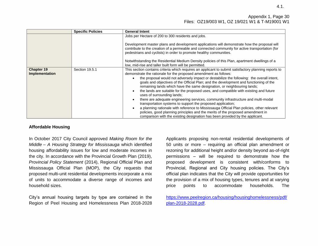
Specific Policies General Intent
Chapter 5 Direct Growth
Section 5.1.6 Section 5.1.8 Section 5.2.1 Section 5.3.2.4 Section 5.3.2.6 Section 5.3.2.11 Section 5.5.7
Mississauga encourages compact, mixed use development that is transit supportive, in appropriate locations, to provide a range of local live/work opportunities. Mississauga will protect employment lands to allow for a diversity of employment uses. The Major Nodes will achieve a gross density of between 200 and 300 residents and jobs combined per hectare. Major Nodes will achieve an average population to employment ratio of between 2:1 to 1:2, measured as an average across the entire area of each node. Development in Major Nodes will be in a form and density that achieves a high quality urban environment. Corridors that run through or abut the Downtown, Major Nodes, Community Nodes and Corporate Centres are encouraged to develop with mixed uses oriented towards the Corridor. A mix of medium and high density housing, community infrastructure, employment, and

Appendix 1, Page 27 Files: OZ19/003 W1, OZ 19/021 W1 & T-M19001 W1
4.1.
Specific Policies General Intent
commercial uses, including mixed use residential/commercial buildings and offices will be encouraged. However, not all of these uses will be permitted in all areas.
Chapter 6 Value The Environment
Section 6.3.7 Section 6.3.8 Section 6.3.10 Section 6.3.24.a & b Section 6.3.26 Section 6.3.47 Section 6.5 Section 6.7 Section 6.9.3 Section 6.9.5 Section 6.10
Buffers are vegetated protection areas that provide a physical separation of development from the limits of natural heritage features and Natural Hazard Lands. Buffers will be determined on a site specific basis as part of an Environmental Impact Study to the satisfaction of the City and conservation authority. The exact limit of components of the Natural Heritage System will be determined through site specific studies such as an Environmental Impact Study. The Natural Heritage System will be protected, enhanced, restored and expanded by ensuring that development in or adjacent to the Natural Heritage System protects and maintains natural heritage features and their ecological functions and placing those areas into public ownership. Development and site alteration will not be permitted within erosion hazards associated with valleylands and watercourse features. In addition, development and site alteration must provide appropriate buffer to erosion hazards, as established to the satisfaction of the City and conservation authority. Incompatible land uses such as sensitive land uses and those uses that are sources of noise, odour and dust will be separated and/or the nuisances will be mitigated, so they do not interfere with each other. If contamination is confirmed, a remedial action plan in accordance with Provincial Government regulations and standards appropriately addressing contaminated sites will be required. Recommendations contained within the plan will be implemented by way of conditions to development approval. The location and operation of waste transfer stations will be located, planned, designed, operated and maintained in such a way as to ensure compatibility with adjacent, existing and future land uses and mitigate dust, odour, health and safety concerns, noise, and visual impacts, within applicable standards. Development with a residential component that will be subject to high levels of noise from a stationary noise source, will only be permitted if noise mitigation measures are implemented at the source of the noise or if the development contains mitigative measures which will result in noise levels that comply with the limits specified by the applicable Provincial Government environmental noise guideline.
Chapter 7 Complete Communities
Section 7.1.6 Section 7.2.1 Section 7.2.2
Mississauga will ensure that the housing mix can accommodate people with diverse housing preferences and socioeconomic characteristics and needs.

Appendix 1, Page 28 Files: OZ19/003 W1, OZ 19/021 W1 & T-M19001 W1
4.1.
Specific Policies General Intent
Section 7.2.3
Mississauga will ensure that housing is provided in a manner that maximizes the use of community infrastructure and engineering services, while meeting the housing needs and preferences of Mississauga residents. Mississauga will provide opportunities for:
a. the development of a range of housing choices in terms of type, tenure and price; b. the production of a variety of affordable dwelling types for both the ownership and rental
markets; and c. the production of housing for those with special needs, such as housing for the elderly
and shelters.
When making planning decisions, Mississauga will ensure that housing is provided in a manner that fully implements the intent of the Provincial and Regional housing policies.
Chapter 8 Create a Multi-Modal City
Section 8.2.1.6 Section 8.2.2.4 Section 8.2.4.3 Section 8.2.4.5 Section 8.2.4.7 Section 8.3.1 Section 8.3.3 Section 8.4 Section 8.5
Mississauga will promote the integration of transportation facilities to maximize opportunities for multi-modal travel. The creation of a finer grain road pattern will be a priority in Intensification Areas. Proponents of development applications, will be required to demonstrate how pedestrian and cycling needs have been addressed. Sidewalks or multi-use trails will be provided on all new roads. Sidewalks or multi-use trails and pedestrian amenities will be a priority in Intensification Areas. Within Intensification Areas and Neighbourhoods, the design of roads and streetscapes will create a safe, comfortable and attractive environment for pedestrians, cyclists and motorists by: a. reducing lane width, where appropriate; b. providing streetscaping to reduce the apparent width of the rights-of-way; c. locating sidewalks and cycling facilities where conflicts with motorized traffic are
minimized; and d. creating safe road crossings for pedestrians and cyclists.
Chapter 9 Build A Desirable Urban Form
Section 9.1.1 Section 9.1.5 Section 9.2.1 Section 9.3.1.5 Section 9.3.1.7 Section 9.3.3 Section 9.3.4 Section 9.3.5 Section 9.4.1 Section 9.4.2
Mississauga will develop an urban form based on the urban system and the hierarchy identified in the city structure as shown on Schedule 1: Urban System. Development on Corridors will be consistent with existing or planned character, seek opportunities to enhance the Corridor and provide appropriate transitions to neighbouring uses. Mississauga will encourage a high quality, compact and urban built form to reduce the impact of extensive parking areas, enhance pedestrian circulation, complement adjacent uses, and distinguish the significance of the Intensification Areas from surrounding areas

Appendix 1, Page 29 Files: OZ19/003 W1, OZ 19/021 W1 & T-M19001 W1
4.1.
Specific Policies General Intent
Section 9.5 Tall buildings will be sited and designed to enhance an area’s skyline. Tall buildings will be sited to preserve, reinforce and define view corridors. Tall buildings will be appropriately spaced to provide privacy and permit light and sky views. The improvement of existing streets and the design of new streets should enhance connectivity by:
a. developing a fine-grained system of roads;
b. using short streets and small blocks as much as possible, to encourage pedestrian movement;
c. avoiding street closures;
Streetscapes will be designed to create a sense of identity through the treatment of architectural
features, forms, massing, scale, site layout, orientation, landscaping, lighting and signage.
Development will support transit and active transportation by:
a. locating buildings at the street edge, where appropriate;
b. requiring front doors that open to the public street;
c. ensuring active/animated building façades and high quality architecture;
d. ensuring buildings respect the scale of the street;
e. ensuring appropriate massing for the context;
f. providing pedestrian safety and comfort; and
g. providing bicycle destination amenities such as bicycle parking, shower facilities and clothing
lockers, where appropriate.
Chapter 13 Major Nodes
Section 13.1.1 Section 13.1.4 Section 13.3
Proponents of development applications within a Major Node may be required to demonstrate how the new development contributes to the achievement of the residents and jobs density target and the population to employment ratio. The Lakeview Waterfront is planned to be an innovative, green model community that incorporates sustainable best practices for buildings and neighbourhoods. An interconnected network of open spaces will provide linkages, both within and to surrounding areas. This network includes parks, trails, and natural hazard lands. Lakefront Promenade, Hydro Road/Street ‘J’, and Street ‘K’ (extension of Haig Boulevard) are important corridors that provide access from Lakeshore Road East to the waterfront and will incorporate enhanced streetscape. Affordable housing will be required in accordance with the City’s housing strategy. Lakeview Waterfront will target a population to employment ration of 2:1 and a Population Plus
Appendix 1, Page 30 Files: OZ19/003 W1, OZ 19/021 W1 & T-M19001 W1
4.1.
Specific Policies General Intent
Jobs per Hectare of 200 to 300 residents and jobs. Development master plans and development applications will demonstrate how the proposal will contribute to the creation of a permeable and connected community for active transportation (for pedestrians and cyclists) in order to promote healthy communities. Notwithstanding the Residential Medium Density policies of this Plan, apartment dwellings of a low, mid-rise and taller built form will be permitted.
Chapter 19 Implementation
Section 19.5.1 This section contains criteria which requires an applicant to submit satisfactory planning reports to demonstrate the rationale for the proposed amendment as follows:
the proposal would not adversely impact or destabilize the following: the overall intent, goals and objectives of the Official Plan; and the development and functioning of the remaining lands which have the same designation, or neighbouring lands;
the lands are suitable for the proposed uses, and compatible with existing and future uses of surrounding lands;
there are adequate engineering services, community infrastructure and multi-modal transportation systems to support the proposed application;
a planning rationale with reference to Mississauga Official Plan policies, other relevant policies, good planning principles and the merits of the proposed amendment in comparison with the existing designation has been provided by the applicant.
Affordable Housing
In October 2017 City Council approved Making Room for the
Middle – A Housing Strategy for Mississauga which identified
housing affordability issues for low and moderate incomes in
the city. In accordance with the Provincial Growth Plan (2019),
Provincial Policy Statement (2014), Regional Official Plan and
Mississauga Official Plan (MOP), the City requests that
proposed multi-unit residential developments incorporate a mix
of units to accommodate a diverse range of incomes and
household sizes.
Applicants proposing non-rental residential developments of
50 units or more – requiring an official plan amendment or
rezoning for additional height and/or density beyond as-of-right
permissions – will be required to demonstrate how the
proposed development is consistent with/conforms to
Provincial, Regional and City housing policies. The City’s
official plan indicates that the City will provide opportunities for
the provision of a mix of housing types, tenures and at varying
price points to accommodate households. The
City’s annual housing targets by type are contained in the
Region of Peel Housing and Homelessness Plan 2018-2028
https://www.peelregion.ca/housing/housinghomelessness/pdf/
plan-2018-2028.pdf.

Appendix 1, Page 31 Files: OZ19/003 W1, OZ 19/021 W1 & T-M19001 W1
4.1.
To achieve these targets, the City is requesting that a
minimum of 10% of new units be affordable. This would
equate to 805 units under the current proposal. The
contribution may be in the form of on-site or off-site units, land
dedication, or financial contributions to affordable housing
elsewhere in the city.

Appendix 1, Page 32 Files: OZ19/003 W1, OZ 19/021 W1 & T-M19001 W1
4.1.
6. School Accommodation
The Peel District School Board The Dufferin-Peel Catholic District School Board
Student Yield:
718 Kindergarten to Grade 5 308 Grade 6 to Grade 8 382 Grade 9 to Grade 12
School Accommodation:
Janet I. McDougald P.S. Enrolment: 450 Capacity: 552 Portables: 0 Allan A. Martin Sr. P.S. Enrolment: 497 Capacity: 538 Portables: 1
Cawthra Park S.S. Enrolment: 1,297 Capacity: 1,044 Portables: 5
Student Yield:
152 Kindergarten to Grade 8 128 Grade 9 to Grade 12
School Accommodation:
Queen of Heaven Elementary School
Enrolment: 345 Capacity: 579 Portables: 0 St. Paul S.S. Enrolment: 475 Capacity: 801 Portables: 0

Appendix 1, Page 33 Files: OZ19/003 W1, OZ 19/021 W1 & T-M19001 W1
4.1.
7. Community Comments
Four community engagement sessions took place in 2019
through the Development Master Plan process. A community
meeting was held by Ward 1 Councillor, Stephen Dasko on
February 27, 2020 which was attended by approximately 100
people.
The following comments made by the community as well as
any others raised at the public meeting will be addressed in
the Recommendation Report, which will come at a later date.
Concerns regarding the additional traffic generated and
the capacity for Lakeshore Road to accommodate more
traffic
Questions regarding where parking will be located and
whether there will be enough
Concern about hospital capacity
Indigenous consultation needs to be part of the process
There are too many towers and the heights are too tall
Concern regarding flooding of the shoreline
8. Development Issues The following is a summary of comments from agencies and departments regarding the applications:
Agency / Comment Date Comments
Region of Peel (April 6, 2020)
The Region is in receipt of the Affordable Housing Brief included as part of the initial subdivision submission. The new Provincial Policy context including the PPS (draft 2019) and Growth Plan (2019) puts significant priority on the provision of affordable housing. Please be advised that in its current state, there is no established Region of Peel incentives program. Regional Staff are open to further discussions and partnerships, based on the preliminary ideas provided including integrating second units in various built forms to accommodate affordable housing and rental housing. The FSR has been received and is under review. Detailed comments will be provided in conjunction with the complete review of the study and all associated plans. The Region, City, and Applicant are involved in ongoing discussions regarding a parcel of land currently under Regional ownership that would complete the proposed Lakefront Promenade road alignment. Prior to draft plan approval the alignment of Lakefront Promenade and satisfactory arrangements with the transfer of all required land from the Region shall

Appendix 1, Page 34 Files: OZ19/003 W1, OZ 19/021 W1 & T-M19001 W1
4.1.
Agency / Comment Date Comments
be made. The Region and Applicant are currently engaged in discussions to determine the feasibility of a vacuum waste collection system on the subject site. Satisfactory arrangements must be made with the Region regarding the implantation/feasibility of a vacuum waste collection system within the development. The Region and Applicant are currently engaged in discussions to determine the feasibility of a district energy system on the subject site. Satisfactory arrangement must be made with the Region and City regarding the implementation of a District Energy system within the development. The Region requests a working group meeting to resolve any outstanding concerns related to the Air Quality, Noise, and Land Use Compatibility and right of way cross sections as it relates to the location of utilities and streetscaping within the right of ways.
Credit Valley Conservation (August 7, 2019)
The property is subject to the Development, Interference with Wetlands, and Alterations to Shorelines & Watercourses Regulation (Ontario Regulation 160/06) as it contains Serson Creek and is adjacent Lake Ontario. Furthermore, the site also contains the hazards (floodplain, slope, erosion) associated with the creek and lake. The FSR (prepared for LCPL, dated February 2019) recognizes the need for quantity controls at three outfalls into Serson Creek based on hydrology/hydraulic model and identifies that this work will be completed at a later stage. Please complete/provide the analysis regarding the approach for quantity control and update the FSR. Erosion control at the three newly proposed outfalls to Serson Creek must be established based on the erosion threshold in the receiving reach unless justified by the qualified fluvial geomorphologist. It is critical that LIDs are constructed to perform the desired function with minimum maintenance. As such, please update the FSR to provide general discussions on inspection, testing and maintenance of LIDs both during and post construction. Please update the FSR to confirm the feasibility of functioning LIDs based on proposed land use in each development blocks. Although the proposed soil amendment has positive impacts on the natural environment it is not a quantifiable form of stormwater control and requires an extensive maintenance program. Alternatively, please demonstrate that preferred structural BMPs including rain gardens, bioretention, etc. have been considered. As identified within the Lakeview Village Shoreline Hazard Assessment (prepared by Baird, dated January 14, 2019) the floodproofing standard elevation is 77.0m CGVD (comprised of the 100-year monthly mean lake level plus the 100-year storm surge plus an allowance for wave action). Please confirm that outfall will not convey lake hazard from outfalls to the neighborhoods. The ultimate design of Serson Creek is to provide direct fish habitat functions in its future configuration; therefore, it is anticipated that the channel design incorporates natural channel design principles to provide physical habitat and flow heterogeneity within the channel, thereby maximizing opportunities for aquatic biodiversity. As such, at the detailed design

Appendix 1, Page 35 Files: OZ19/003 W1, OZ 19/021 W1 & T-M19001 W1
4.1.
Agency / Comment Date Comments
stage, it is anticipated that the design will further include dense and diverse buffer plantings within the proposed low-flow channel where the functional creek system will occur.
Dufferin-Peel Catholic District School Board and the Peel District School Board (February 10, 2020)
Based on the Dufferin-Peel Catholic District School Board's School Accommodation Criteria, the Board is satisfied with the current provision of educational facilities for the catchment area in which the subject application is located. The City of Mississauga school accommodation condition need not be applied. The applicant shall agree in the Servicing and/or Subdivision Agreement to include certain clauses regarding student accommodation in all offers of purchase and sale. Based on the current residential development numbers proposed for Inspiration Lakeview the Peel District School Board will not be able to accommodate all anticipated students in existing schools. According to our assessment of school accommodation needs, the Board requires one (1) elementary school site of 3.24 hectares (8 acres) south of Lakeshore Road East and within the site. This is the Board standard site requirement for an 850 pupil place elementary school. The school site is to be centrally located within the community and be made available in the first phases of development. Prior to registration of the plan, satisfactory arrangements shall have been made with the Peel District School Board for the acquisition, or reservation for future acquisition, of the future school block. In order to ensure that sanitary, storm, and utility easements do not interfere with site plan approval for the proposed facility, it is requested that such easements be approved by the School Accommodation Department prior to establishment on the proposed school site. The Board requires that certain clauses regarding student accommodation be placed in any agreement of purchase and sale entered into with respect to any lots on this plan, within a period of five years from the date of registration of the subdivision agreement.
City Community Services Department – Park Planning Section (April 30, 2020)
Community Services Department notes that pursuant to Section 42 of the Planning Act, parkland conveyance is calculated at a rate of 1 ha /300 units. The subject development is proposing approximately 8,050 residential units and, under S.42 of the Planning Act, approximately up to 27 ha (66.7 acres) of public parkland can be required to fulfill parkland dedication requirements. The proposed development is planning for 14.42 ha (35.63 ac) of Public Open Space system within this site to partially fulfill S.42 requirements. This proposal is comprised of a destination park (lakefront) and several linear parks (Waterway Common, Ogden and Aviator) representing approximately 20% of the total site area. The proposed Public Open Space also includes hazard lands representing 11.97 ha (29.58 ac). Parkland Dedication credits for this development will be determined upon finalization of proposed park block sizes. This Department further notes that pursuant to City of Mississauga Council endorsed corporate policy 07-07-21: Dedication of Land or Cash in Lieu, thereof, for Public Open Space, parkland conveyance credit will not be applied towards hazard lands. Parkland conveyance credit for the proposed Public Open Space will be determined upon finalization of the proposed Public Open Space system. This Department also supports continuous unobstructed public access and a view corridor from the linear park to the lakefront park. A revised wind study to include tunnel analysis is required to determine the impact the proposed residential buildings abutting the proposed City conveyed parks are not substantially impacted. Additional information and further review will be required through the application process, in consultation with Planning and Building and Transportation and Works Department, to assess:

Appendix 1, Page 36 Files: OZ19/003 W1, OZ 19/021 W1 & T-M19001 W1
4.1.
Agency / Comment Date Comments
Proposal of Low Impact Development (LID) within future public open space and public right of way (ROW) boulevard
Public right-of-way hierarchy
Wind Study (tunnel wind analysis) is required to determine the impact at street level and within the proposed parks the impact wind may have from the proposed apartment buildings aligning the parks.
Municipal Lands Agreement
Proposed Zoning By-law for Public Open Space System
Serson Creek Corridor Design. Two of the key issues (among others) from our review are as follows: o the clarification regarding the 6.0m buffer within the limits of hazard; and o the channel reconstruction planting plans along the 3:1 slope to top of bank, and 6 m (20 ft.) buffer.
Community Services continues to work with LCP to discuss the park design / development agreement, park public engagement process, park program and costing.
City Community Services Department – Culture and Heritage Planning Section (March 18, 2020)
Detailed commentary regarding the adjacent heritage property has been provided through the Application Status Report. Heritage planning supports the recommendations and continues to engage with the applicant to finalize the heritage impact assessment report. The Culture Division is actively working with Lakeview Community Partners and Artscape in order to determine the terms and feasibility of a pilot project to incorporate artwork and placemaking onsite at Lakeview and across Mississauga through public and private investments.
Economic Development Office (March 17, 2020)
We have a concern with the proposed uses for the “E2-XX” zone that will form the basis of the zoning for the Innovation Corridor. As an innovation corridor, uses may vary from information technology, clean tech to laboratories, biotechnology and pharmaceuticals as examples. It is really any use that requires a complex air filtration system and may have to adhere to strong regulations from the Ministry of the Environment, Health Canada, and/or any similar regulatory body. We have insufficient information to understand if the uses proposed would impact the operations of the uses we are trying to attract to the innovation corridor, specifically biotechnology, pharmaceutical companies, laboratories, etc. The applicant needs to demonstrate that the proposed uses will not impact the innovation corridor.
City Transportation and Works Department (March 26, 2020)
Through the OPA submission, the applicant is requesting changes to various figures and maps within the Lakeview Area Secondary Plan that relate to roads and street hierarchy. We are currently reviewing the proposed changes and comments will be provided through the current draft plan submission in conjunction with the Street Hierarchy and Rights-of-way Study. Based on a review of the materials submitted to date, the owner has been requested to provide additional technical details and revisions prior to the City making a recommendation on the application, as follows: Drawings and Reports
The owner is to provide full size, to scale, Plan and Profile drawings, Overall Grading Plans and also Overall Servicing Plans. These engineering drawings are to be properly formatted and are to depict all the municipal road dimensions, turning circles, services, noise barriers, buffer blocks, etc. and to ensure there are no negative drainage impacts to adjacent properties. Detailed engineered cross-sections are also required and are to be taken at frequent intervals. Revisions have

Appendix 1, Page 37 Files: OZ19/003 W1, OZ 19/021 W1 & T-M19001 W1
4.1.
Agency / Comment Date Comments
also been requested to the Draft Plan, Noise Study and Geotechnical Report. Municipal Works
Municipal Works will be required to support this development and these works shall form part of the Subdivision Agreement. Detailed design, securities and insurance will be addressed through the Subdivision Agreement. Stormwater
A Functional Servicing Report (FSR) dated February 2019 and Master Drainage plan dated August 2019, prepared by Urbantech, was submitted in support of the proposed development. The purpose of the reports is to evaluate the proposed development impact on the municipal drainage system (e.g., storm sewers, watercourses, etc.) and to mitigate the quality and quantity impacts of stormwater run-off generated from the site. Mitigation measures may include improvements to existing stormwater servicing infrastructure, new infrastructure and/or on-site stormwater management controls. The applicant is proposing to construct new storm sewers to service the development lands and all public roads, with multiple outlets to Lake Ontario and Serson Creek. In addition on-site and road right-of-way stormwater management controls are proposed for the post-development discharge and realignment of Serson Creek. The proposed plan will require additional approvals, including Credit Valley Conservation. The applicant is required to provide further technical information to:
demonstrate the feasibility of the proposed stormwater servicing including an acceptable strategy to accommodate external flow from adjacent properties;
demonstrate that there will be no impact on the City’s existing drainage system including how groundwater will be managed on-site;
detail the proposed Serson Creek works including channel design, maintenance access, easements/land dedication, conservation authority approval, etc.; and
enter into a subdivision agreement to construct the new municipal stormwater services.
Environmental Compliance
The Environmental Site Screening Questionnaire and Declaration and Due Diligence Phase I and Phase II Environmental Site Assessment (ESA) reports, both prepared by EXP Services Inc., were submitted in support of the proposed development. The reports indicate the presence of contamination exceeding applicable site condition standards and that further investigation work is required. A Remedial Action Plan is required to demonstrate how contamination on the property will be satisfactorily addressed to meet the applicable standards. Further environmental comments may be forthcoming pending review of the above. Under the City of Mississauga Fees and Bylaw Charges, Environmental Services may retain a third party peer reviewer for all environmental reports. A Record of Site Condition is required in accordance with the Ministry of Environment, Conservation

Appendix 1, Page 38 Files: OZ19/003 W1, OZ 19/021 W1 & T-M19001 W1
4.1.
Agency / Comment Date Comments
and Parks regulations. Traffic
A Traffic Impact Study prepared by The Municipal Infrastructure Group Ltd. was submitted in support of the DMP 3.0. Based on the changes proposed in the Official Plan Amendment, the applicant will be required to submit an updated Traffic Impact Study to the satisfaction of T&W that captures all changes from Development Master Plan 3.0 to Development Master Plan 4.0. Under the City of Mississauga Fees and Bylaw Charges, Traffic Planning may retain a third party peer reviewer for the required updated Traffic Impact Study. The proposed alignment of Lakefront Promenade south of Rangeview Road and the proposed roundabout at the intersection of Lakefront Promenade and Street A encroach onto Region of Peel lands. The applicant is required to engage with the Region of Peel. Turning Templates submitted under the Streets Hierarchy & Right-of-Way Study were deemed not acceptable by City staff as swept paths for vehicles are not permitted to overlap adjacent lanes when attempting to make a turn. A revised study must be submitted for review addressing the swept path analysis with additional approval from Fire & Emergency Services. The above aspects will be addressed in detail prior to the Recommendation Meeting. Updates to all appropriate drawings and reports will be necessary upon receipt of any changes to the proposal.
Fire Prevention (January 15, 2020)
This proposal is located within the response area of Fire Station 102. At present average travel times to emergencies in this area of the City is 4 minutes based on normal traffic and weather conditions. We have no concerns regarding response times. As there are no water mains installed in this area we could not assess the potential flow for this new development. Confirmation from the Region of Peel will be required indicating the proposed water main system for this area will be adequate for this proposal. Mississauga Bylaw 1036-81 (fire access routes) is applicable to this development. This bylaw regulates the location of the fire access route with respect to exposure to, and distance from the various proposed structures. Additionally, it limits the unobstructed travel distance for a fire fighter from the edge of the fire route to the main entrance to every dwelling unit. Unless drawings can be provided showing greater detail of the various proposed building types (height, location, configuration, etc) and the locations of the fire access routes, we will not be able to comment on whether the requirements of By-Law 1036-81 can be met throughout the development. If this is the case, compliance with By-Law 1036-81 will be assessed at the time of site plan approval.
Bell (April 5, 2019)
The Owner shall indicate in an Agreement, that it will grant to Bell Canada any easements that may be required, which may include a blanket easement, for communication/telecommunication infrastructure. In the event of any conflict with existing Bell Canada facilities or easements, the proponent shall be responsible for the relocation of such facilities or easement.
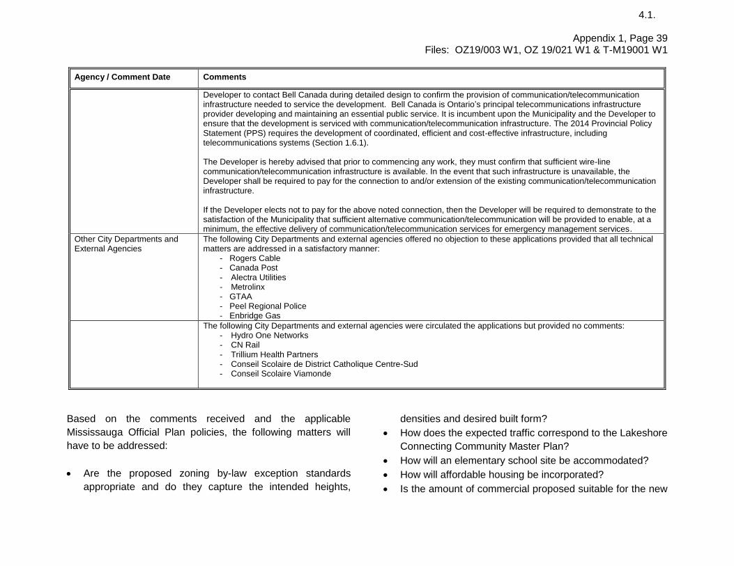
Appendix 1, Page 39 Files: OZ19/003 W1, OZ 19/021 W1 & T-M19001 W1
4.1.
Agency / Comment Date Comments
Developer to contact Bell Canada during detailed design to confirm the provision of communication/telecommunication infrastructure needed to service the development. Bell Canada is Ontario’s principal telecommunications infrastructure provider developing and maintaining an essential public service. It is incumbent upon the Municipality and the Developer to ensure that the development is serviced with communication/telecommunication infrastructure. The 2014 Provincial Policy Statement (PPS) requires the development of coordinated, efficient and cost-effective infrastructure, including telecommunications systems (Section 1.6.1). The Developer is hereby advised that prior to commencing any work, they must confirm that sufficient wire-line communication/telecommunication infrastructure is available. In the event that such infrastructure is unavailable, the Developer shall be required to pay for the connection to and/or extension of the existing communication/telecommunication infrastructure. If the Developer elects not to pay for the above noted connection, then the Developer will be required to demonstrate to the satisfaction of the Municipality that sufficient alternative communication/telecommunication will be provided to enable, at a minimum, the effective delivery of communication/telecommunication services for emergency management services.
Other City Departments and External Agencies
The following City Departments and external agencies offered no objection to these applications provided that all technical matters are addressed in a satisfactory manner:
- Rogers Cable - Canada Post - Alectra Utilities - Metrolinx - GTAA - Peel Regional Police - Enbridge Gas
The following City Departments and external agencies were circulated the applications but provided no comments: - Hydro One Networks - CN Rail - Trillium Health Partners - Conseil Scolaire de District Catholique Centre-Sud - Conseil Scolaire Viamonde
Based on the comments received and the applicable
Mississauga Official Plan policies, the following matters will
have to be addressed:
Are the proposed zoning by-law exception standards
appropriate and do they capture the intended heights,
densities and desired built form?
How does the expected traffic correspond to the Lakeshore
Connecting Community Master Plan?
How will an elementary school site be accommodated?
How will affordable housing be incorporated?
Is the amount of commercial proposed suitable for the new

Appendix 1, Page 40 Files: OZ19/003 W1, OZ 19/021 W1 & T-M19001 W1
4.1.
community?
Can a suitable alternate site be found for the Parks Depot
in Lakefront Promenade Park in order to allow Lakefront
Promenade Road to be realigned?
What measures will be taken to appropriately realign
Serson Creek?
Has air quality and odour been addressed?
Are appropriate urban design guidelines being
implemented?
Has enough parking been provided for the commercial
uses and where will it be located?
Have the layouts and structures been designed to allow
pedestrian permeability?
How will sustainable technologies form part of the
proposal?
Has there been an adequate amount of employment
programmed into the plan and is it achieving a 2:1
population to employment ratio?
When will the 67 acres of waterfront dedication come to
the City and what area will it include?
Development Requirements There are engineering matters including: environmental,
engineering, servicing and stormwater management that will
require the applicant to enter into agreements with the City.
Prior to any development proceeding on-site, the City will
require the submission and review of applications for site plan
approval.
9. Section 37 Community Benefits (Bonus
Zoning)
Should these applications be approved by Council, staff will
report back to Planning and Development Committee on the
provision of community benefits as a condition of approval.
K:\PLAN\DEVCONTL\GROUP\WPDATA\PDC Information Report Appendix\OZ 19 003 Lakeview\Appendix 1
Information Report.docx