Embed Size (px)
Citation preview
Planning for the future of Barking and DagenhamSite Specific Allocations Development Plan Document
Local Development Framework
Adopted December 2010

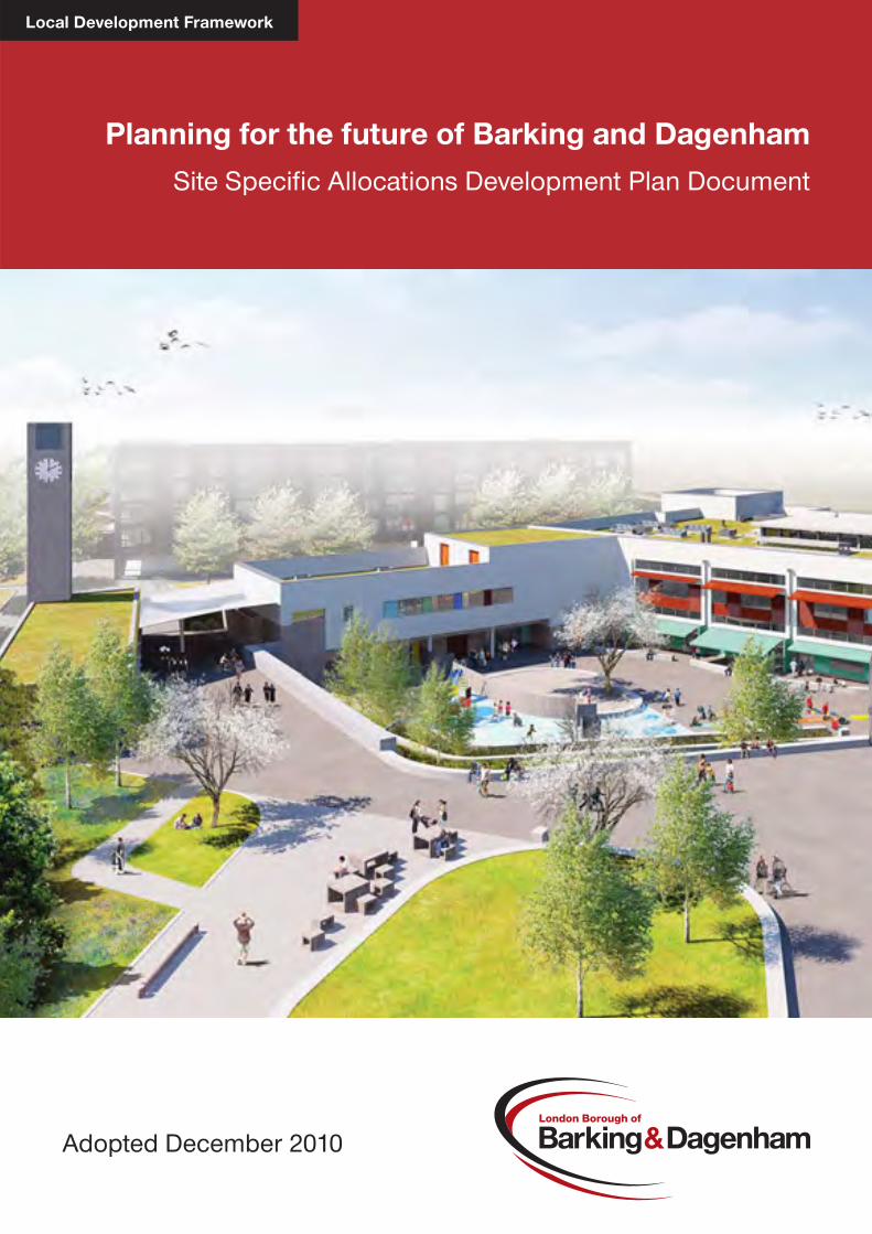
Cover image: Rivergate Centre, Barking Riverside © Barking Riverside Ltd, van Heyningen and Haward Architects and i-ma-ge
2
1 Introduction and Background ......................................................................... 4 Consultation and Sustainability Appraisal ........................................................... 5 Integration of Strategies and Conformity ............................................................ 6 Structure of this Document ................................................................................. 7
2 Managing Growth ............................................................................................. 8 Key Regeneration Areas and Significant Housing Sites ............................. 10 SSA SM1 Barking Riverside ............................................................................. 10 SSA SM2 South Dagenham West and Dagenham Leisure Park ...................... 12 SSA SM3 Barking Rugby Club and Goresbrook Leisure Centre ...................... 15 SSA SM4 South Dagenham East ..................................................................... 16 SSA SM5 Sanofi Aventis Site 2…………………………………….……………....18 SSA SM6 University of East London ................................................................ 19 SSA SM7 Robin Hood Public House ................................................................ 20 SSA SM8 Lymington Fields .............................................................................. 21 SSA SM9 Beacontree Heath – Seabrook Hall .................................................. 22 SSA SM10 Beacontree Heath – Wider site ...................................................... 23 SSA SM11 Hedgecock Centre ......................................................................... 24 SSA SM12 Upney Lane Centre ........................................................................ 25 SSA SM13 Thames View Regeneration Sites .................................................. 26 SSA SM14 Mark’s Gate Regeneration Sites .................................................... 28 SSA SM15 Goresbrook Village ......................................................................... 30 Minor Housing Sites ....................................................................................... 31 Non Garage Sites ............................................................................................. 33 SSA SM16 243 - 245A High Road .................................................................... 33 SSA SM17 Roger’s Road Depot, 81-83 Roger’s Road ..................................... 33 SSA SM18 Earls Walk Car Park ....................................................................... 33 SSA SM19 Mayesbrook Residential Care Home .............................................. 33 SSA SM20 Maplestead Road Car Park ............................................................ 33 SSA SM21 Land adjacent to 1a Essex Road ................................................... 34 SSA SM22 135 Bromhall Road Depot and Surgery ......................................... 34 Vacant Garage Sites ........................................................................................ 34 SSA SM23 Garages rear of 289-309 Heathway ............................................... 34 SSA SM24 Burford Close Garages .................................................................. 34 SSA SM25 Beamway Garages ......................................................................... 34 SSA SM26 Garages to rear of 53-57 Wellington Drive ..................................... 34 SSA SM27 58-62 Church Street ....................................................................... 34 Garage Sites Still Occupied .............................................................................. 35 SSA SM28 Garages rear of 13-15 Highland Avenue, Dagenham .................... 35 SSA SM29 Mellish Close Garages ................................................................... 35 SSA SM30 Garages in front of 58-61 Alfred Gardens ...................................... 35 SSA SM31 Thornhill Gardens Garages ............................................................ 35 SSA SM32 Stansgate Road Garages and retail parade 25-39 Stansgate Road…………………………………………………………………………………...36 SSA SM33 Garage site, Waterbeach Gardens ................................................. 36 Transport Infrastructure Sites ....................................................................... 36 SSA SM34 Renwick Road Junction .................................................................. 36 SSA SM35 Freight Infrastructure at Renwick Road/Ripple Road ..................... 37 SSA SM36 Safeguarding for ELT1A and 1B .................................................... 39 Town Centre Hierarchy .................................................................................. 40 District Centre Site (DC1) - Chadwell Heath ..................................................... 40
3
District Centre Site (DC2) – Dagenham Heathway ........................................... 41 District Centre Site (DC3) – Green Lane .......................................................... 41 Neighbourhood Centres ................................................................................... 42
3 Sustainable Resources and the Environment ............................................. 44 Allotments ....................................................................................................... 44 Future Allotment Site ........................................................................................ 46 SSA SR1 Groveway Allotments ........................................................................ 46 Open Space ..................................................................................................... 46 Future Open spaces ......................................................................................... 49 Sites of Importance for Nature Conservation .............................................. 50 Future Sites of Importance for Nature Conservation ........................................ 51
4 Creating a Sense of Community ................................................................... 52 Schools……………………………………………………………………………….54 SSA SC1 Cannington Road .............................................................................. 54 SSA SC2 St. George’s Centre .......................................................................... 54 Community Uses ............................................................................................ 54 SSA SC3 Japan Road Community Centre ....................................................... 54 SSA SC4 Whalebone Lane South……….….……………………………………..55 Healthcare ....................................................................................................... 56 SSA SC5 Westbury Arms ................................................................................. 56 SSA SC6 Julia Engwell Clinic ........................................................................... 56 SSA SC7 Brockelbank Lodge ........................................................................... 57 Barking Riverside SSA SC8 A-D Barking Riverside - New neighbourhood and district centres……………………………………………………………………………..….58
5 Ensuring a Vibrant Economy and Attractive Town Centres..…………...…63 Strategic Industrial Locations ....................................................................... 63 The Rippleside Strategic Industrial Location ..................................................... 63 The River Road Strategic Industrial Location ................................................... 64 Locally Significant Industrial Sites ............................................................... 64 SSA SE1 Lyon’s Business Park and neighbouring employment uses to the south .............................................................................................. 64 The Sanofi Locally Significant Industrial Site .................................................... 65
6 Monitoring and Implementation .................................................................... 66 Appendix 1: Saved UDP policies……………………………………………………70 Appendix 2: Maps…………………………………………………………………….77 Addendum: Chapter 2 Transport Infrastructure Sites
Chapter 2 Town Centre Hierarchy…………..………………………126
4
Chapter 1: Introduction and Background 1.1 This report represents a major stage in the London Borough of Barking
and Dagenham’s work to replace the old-style Unitary Development Plan (1995) with a new Local Development Framework or LDF. The requirement to produce an LDF was established by the Planning and Compulsory Purchase Act 2004, which came into force in September 2004.
1.2 The new LDF system aims to achieve sustainable development
through a spatial planning approach. 1.3 The Site Specific Allocations Development Plan Document is a key part
of the Council’s Local Development Framework. It includes those sites which are necessary to deliver the Core Strategy and enable the implementation of the Borough Wide Development Polices. These are:
Chapter 2 – Managing Growth
Key Regeneration Areas and Significant Housing Sites. These are the sites necessary to deliver the additional homes target set out in Core Strategy policy CM2. It also includes estate regeneration schemes.
Minor Housing Sites. These are small sites which the Council considers have potential to provide new housing. These sites will help maximise the supply of new housing and in particular affordable housing.
Transport Infrastructure Sites. These are the transport infrastructure sites necessary to deliver policy CM4 of the Core Strategy.
Town Centre Hierarchy. This details the extent of the frontages which comprise the centres within the town centre hierarchy as listed in policy CM5 of the Core Strategy and which will be used in applying the Borough Wide Development Policies DPD.
Chapter 3 - Sustainable Resources and the Environment
Allotments. This lists the allotment sites which are protected by the Borough Wide Development Policies DPD. It also includes a proposal to bring back into use an existing allotment.
Open Space. This lists the public open spaces which are protected under policy CM3 of the Core Strategy.
Sites of Importance for Nature Conservation. This lists the Sites of Importance for Nature Conservation which are protected under policy CR2 of the Core Strategy.
5
Chapter 4 – Creating a Sense of Community
This chapter comprises sites for new community facilities, particularly schools and health facilities, necessary to meet existing needs and new need arising from the housing growth identified in policy CM2 of the Core Strategy. Chapter 4 focuses on standalone facilities. Where necessary, community facilities are also identified within the large housing sites included in Chapter 2.
Chapter 5 – Ensuring a Vibrant Economy and Attractive Town Centres
This chapter identifies revisions to the Strategic Industrial Locations and Locally Significant Industrial Sites listed in policy CE3 of the Core Strategy.
1.4 The Proposals Map shows the boundaries of SSA SM1 – SSA SM36,
all the frontages which comprise the District Centres and Neighbourhood Centres listed in Chapter 2, the allotment sites, public open spaces, and Sites of Importance for Nature Conservation listed in Chapter 3, the boundaries of SSA SC1 – SSA SC8D which comprise Chapter 4, and the revised boundaries of the Strategic Industrial Locations and Locally Significant Industrial Sites detailed in Chapter 5. Detailed plans of all the Site Specific Allocations, SSA SM1 – SSA SM36, SSA SR1, SSA SC1 – SSA SC8D and SSA SE1 are included in Appendix 1 of this document. The information in this document with regard to progress with the sites and their expected timescale is correct as of April 2010.
1.5 Through this document and the Barking Town Centre Area Action Plan
the Council has focused on identifying sufficient sites to deliver its housing target of 1,190 new homes per year from 2009/10 – 2023/24 and to provide the necessary social infrastructure to support this. More detail is provided in the Housing and Implementation Strategy provided in the Core Strategy. This includes new schools, new health centres and safeguarding for new public transport schemes.
1.6 Sites within Barking Town Centre are covered by the Barking Town
Centre Area Action Plan. Waste management sites are covered by the Joint Waste Plan.
Consultation and Sustainability Appraisal 1.7 In August 2008 the Council published its comprehensive Site Specific
Allocations Issues and Options Report for public consultation. This report identified the possible significant future development opportunities across the borough, and sought the views of residents and other stakeholders on these.
1.8 The sites were identified from a number of sources:
6
Sites identified through the London Housing Capacity Study Sites identified through the multi agency regeneration of London Riverside Sites put forward by the London Borough of Barking and
Dagenham Sites with planning permission Sites with developer interest
1.9 The Council’s response to the feedback received is presented in the
Consultation Report. The Council has addressed this feedback in defining the final draft list of sites and their preferred future uses. It has also identified the environmental, economic and social impacts of these sites through a sustainability appraisal and taken the necessary mitigating measures.
Integration of Strategies and Conformity 1.10 The Site Specific Allocations have been identified to help deliver the
Core Strategy of the Local Development Framework. The LDF has a key role in providing a spatial dimension for many other strategies and helping in their co-ordination and delivery throughout Barking and Dagenham.
1.11 Three strategies are particularly critical: the London Plan, the Barking
and Dagenham Community Strategy and the Council’s Asset Management Plan. The Site Specific Allocations needs to be in general conformity with the London Plan. The London Plan, which incorporates all the alterations made to it since 2004, was published in February 2008. The draft replacement London Plan was published for consultation in October 2009. The LDF also provides the main means of giving spatial expression to the Barking and Dagenham Community Strategy. The Core Strategy evidences the relationship with the Community Strategy and it is not necessary to repeat it here. The Council is a significant landholder and therefore the site allocations work was tied in with the work of the Asset Management Plan. In addition, there are many other strategies at regional, sub-regional and local level that have been taken into account.
1.12 The Council has also had regard to a comprehensive evidence base
including Strategic Flood Risk Assessment, London Housing Capacity Study, Barking and Dagenham Housing Needs Survey, Sites of Importance for Nature Conservation Survey, Barking and Dagenham Green Space Strategy and Barking and Dagenham Town Centre Health Checks. Each site has been sequentially tested to evidence that there are no opportunities for locating the development in a lower flood risk zone.
1.13 Preparation of the Site Specific Allocations is not a once and for all
activity. It is essential to check that they are being implemented as
7
intended, that the desired outcomes are being achieved and, if not, what corrective action needs to be undertaken. The progress in the delivery of the sites will be monitored in the Annual Monitoring Report. More information is provided in Chapter 6.
Structure of this Document 1.14 The Core Strategy policies fall under one of five themes:
Managing Growth Sustainable Resources and the Environment Creating a Sense of Community Ensuring a Vibrant Economy and Attractive Town Centre Creating a Sense of Place
1.15 The identified sites are necessary to deliver the Core Strategy and
therefore are grouped under the respective themes as shown overleaf. Each chapter begins by setting out the context for the identified sites having regard principally to the Core Strategy.
Chapter 2: Managing Growth
Key regeneration areas and significant housing sites Minor housing sites Transport Infrastructure sites Town Centre hierarchy
Chapter 3: Sustainable Resources and the Environment
Allotments Open Space Sites of Importance for Nature Conservation
Chapter 4: Creating a Sense of Community
Schools and children’s centres Community uses Healthcare Barking Riverside new neighbourhood and district centres
Chapter 5: Ensuring a Vibrant Economy and Attractive Town Centres
Strategic Industrial Locations Locally Significant Industrial Sites
The last chapter covers the Monitoring and Implementation Framework.
8
Chapter 2: Managing Growth 2.1 This chapter comprises sites which have been identified to deliver the
Managing Growth theme of the Core Strategy which covers policies CM1 – CM5.
2.2 Policy CM2 of the Core Strategy identifies in line with the London Plan
that at least 11,900 new homes will be provided in Barking and Dagenham between 2007/08 and 2016/17. This target will largely be met from new housing from the following sources:
Barking Riverside Barking Town Centre South Dagenham; and Further housing and mixed use development sites identified in the
Site Specific Allocations DPD 2.3 The Council will cooperate with the GLA in setting an appropriate target
for the borough of the subsequent ten year period to 2026/27 and will plan to deliver housing in line with future GLA guidance and targets that derive from that process.
2.4 Barking Riverside and South Dagenham are covered in more detail in
SM1, SM2 and SM3. Opportunities within Barking Town Centre are covered in more detail in the Barking Town Centre Area Action Plan.
2.5 Policy CM2 of the Core Strategy ‘Managing Housing Growth’ identifies
that outside of the Key Regeneration Areas further housing and mixed use development opportunities will be identified. These opportunities are split into two categories, significant housing sites and minor housing sites. It is important to note that these definitions do not correspond to the strategic and major definitions used in elsewhere in the LDF and set out in the glossary of the Core Strategy. This is because the exact capacity of these sites will not be known until detailed proposals have been worked up.
2.6 The Council calculates that the sites included in the document will yield
approximately 14,800 hew homes by 2025. This comprises 7,500 dwellings at Barking Riverside (SSA SM1), 4,000 dwellings at South Dagenham (SSA SM2 and SSA SM4), 3,181 dwellings on major sites outside the Key Regeneration Areas and 164 dwellings on small sites (SSA SM16 – SSASM33). In addition the site allocations in the Barking Town Centre Area Action Plan total 5,016 new dwellings. The overall total therefore across the Borough is 19,861 new dwellings. Policy CM2 of the Core Strategy sets a target of 1,190 new homes per year to 2025 which represents 17,850 new dwellings over the lifetime of the plan. Therefore the Site Specific Allocations DPD and the Barking Area Action Plan DPD identify sufficient supply to surpass the Council’s
9
housing supply target. More detail is provided in the Council’s Housing and Implementation Strategy.
2.7 In line with Policy CM1 of the Core Strategy ‘General Principles for
Development’ the Council wants to achieve mixed and balanced sustainable communities. Consequently, acting on the feedback received from key service providers, it has identified where appropriate, the need for essential community facilities to support the development. These will be provided in one of two ways. Provided as part of the development of key regeneration areas and significant housing sites or as standalone facilities dealt with in Chapter 4.
2.8 Good progress has already been made on many of these schemes.
Many of these sites are being delivered by the Council and/or its partners including Barking Riverside Limited, the Local Housing Company, Homes and Communities Agency, the London Development Agency and the London Thames Gateway Development Corporation.
2.9 For each site the appropriate uses are stated and the main issues
which must be addressed in the development listed. However all development proposals must in addition satisfy the policies and guidance within the Local Development Framework and the London Plan.
2.10 Whilst sites SSA SM1 – SSA SM15 will deliver a significant amount of
new housing they are also concerned, in line with Policy CM1 of the Core Strategy, with improving conditions on existing estates within the borough. There is a pressing need to improve housing conditions on the Thames View Estate, Marks Gate Estate and at Goresbrook Village and SSA SM13, SSA SM14 and SSA SM15 set out the Council’s proposals for these three areas. Although these proposals involve the demolition of a significant number of homes which do not meet decent homes standard in total there will be net gain of new homes across these three areas.
2.11 SSA SM16 – SSA SM33 comprise the minor housing sites. Collectively
these sites will help maximise the supply of new housing in line with Policy CM2 of the Core Strategy and will also help increase the supply of affordable housing as many of these sites will be for new Council housing.
2.12 SSA SM34 – SM36 covers the transport infrastructure sites necessary
to deliver Policy CM4 of the Core Strategy. Policy CM4 makes clear that land will be safeguarded for planned transport infrastructure schemes in the Site Specific Allocations SPD that will serve the economic, social and environmental needs of the Borough and the Thames Gateway area.
10
SSA SM34 covers the safeguarding for the A13/Renwick Road junction improvements which are necessary to deliver the Barking Riverside development as set out in SSA SM1.
SSA SM35 covers the proposed Strategic Rail Freight Terminal at Renwick Road/Ripple Road. This site enjoys connection to a high speed rail link to continental Europe. The allocation plans for expansion of existing rail freight activity as well as new businesses anticipated to locate in the area in connection with the freight terminal. It also provides for affordable business space for existing businesses. The allocation therefore will help modernise the Rippleside Commercial Area and increase employment levels within it.
SSA SM36 covers the safeguarding for East London Transit Routes 1a and 1b which are important improvements to public transport which will significantly improve public transport accessibility to London Riverside and are essential to deliver the Barking Riverside development.
2.13 The end of this chapter details the extent of the frontages which
comprise the centres within the town centre hierarchy as listed in Policy CM5.
Key Regeneration Areas and Significant Housing Sites
SSA SM1: BARKING RIVERSIDE Location On the River Thames between the River Road and
Dagenham Dock Strategic Industrial Locations, south of the A13.
Size 150 hectares Timescale 2009 - 2030 Implementation Barking Riverside Ltd - a joint venture between the
Homes and Communities Agency and Bellway Homes. Flood Zone1 Flood risk Zone 1 but surrounded by flood risk Zone 3. PTAL2 Existing PTAL is 1. However East London Transit phases
1a and 1b will serve Barking Riverside. A DLR extension to Dagenham Dock is also anticipated.
Indicative Up to 10,800 new homes, which will be phased to
1 The risk of land from flooding depends on which Flood Zone it falls within. These Flood Zones refer to the probability of sea and river flooding only, ignoring the presence of existing defences. There are four flood zones - 1 is lowest probability, 2 is medium probability, 3a is high probability and 3b is the functional floodplain. More information can be found in Planning Policy Statement 25: Development and Flood Risk. 2 PTAL is the Public Transport Accessibility Level. This is a measure of how accessible a location is to public transport taking into account service frequency and the distance to a public transport node (station or bus stop). PTAL is ranked 1- 6, with 6 representing excellent public transport accessibility.
11
Capacity coincide with the provision of key public transport and road improvements and provision of essential community facilities. There are a number of conditions on the existing planning consent which ensure this. This includes conditions restricting the number of homes that can be occupied to no more than 1500 homes before a Transport and Works Act (authorising the construction and operation of the DLR) is in place and no more than 4,000 homes before the Docklands Light Railway Extension is operational. It also includes conditions restricting the number of homes that can be occupied to 3,999 before improvements to the Renwick Road/A13 junction have been completed.
Existing Uses Unoccupied brownfield land. Proposed Uses and Design Requirements Barking Riverside is located at the heart of the Thames Gateway and when fully developed will comprise approximately 10,800 new mixed-tenure homes within a high quality urban environment and also a range of community facilities. These will include: schools, healthcare, shopping, community facilities, employment, leisure opportunities and environmental benefits all supported by new, integrated public transport links. Over a 20 year period Barking Riverside will emerge as a vibrant, sustainable community which will be home to 26,000 people, with strong links to nearby existing neighbourhoods like Thames View. A major emphasis is on the provision of high levels of multi-tenure affordable and family homes which are being designed innovatively to high sustainability standards. Of the site, 40% will be dedicated to open spaces and the 2km riverfront will be opened up. Outline consent (application reference 04/00123/OUT) for the whole site was issued, and a comprehensive Section 106 agreement signed, in 2007. This provides for up to 10,800 net new homes over a four stage development programme which will take place over a 25 year period. A Section 73 planning application for variation of six conditions attached to the original outline planning permission was granted in June 2009 and in August 2009, four planning applications were approved to discharge a number of conditions that were attached to the original planning permission. In February 2010, a reserved matters planning application was granted to provide the detailed design of the first local centre, the Rivergate Neighbourhood Centre. Further planning applications will be submitted during 2010 as development progresses. East London Transit will serve early phases with stages three and four dependent on the DLR being extended to Dagenham Dock. The phasing of the scheme has been carefully planned to ensure that as the
12
area grows the necessary community and transport infrastructure will be provided alongside it. The Section 106 agreement and conditions on the outline consent provide for this. Each of the four ‘stages’ will include a new neighbourhood or district centre providing community hubs with schools, religious meeting places and other social infrastructure and retail provision. More details on each of the four new centres are set out later in this document. Development must address the following issues: The site contains and is bounded by SINCs, where biodiversity / nature
conservation interests will require careful reconciliation with regeneration and development aspirations.
The need to address effects on both the local road network and the Strategic Road Network as identified in a Transport Assessment and the need to remediate any adverse transport impacts.
SSA SM2: SOUTH DAGENHAM WEST AND DAGENHAM LEISURE PARK Location South Dagenham West is situated to the west of the Ford
Stamping Plant and east of the Goresbrook Interchange. It is bounded to the south and north by the A13 and the A1306. Dagenham Leisure Park is situated to the west of the Goresbrook Interchange, north of the A13 and South of Goresbrook Road and Baden Powell Close.
Ward Goresbrook, River and Thames Size 28.56 and 3.40 hectares Timescale 2013 – 2020 South Dagenham West
2013 – 2020 Dagenham Leisure Park Implementation The majority of South Dagenham West is owned by AXA.
There are a number of small areas of land adjacent to AXA’s land that should ideally be incorporated within the overall development site. These include the Chequers Corner/Polar site to the east. Dagenham Leisure Park is in private ownership. LBBD favours a comprehensive masterplanning approach encompassing both sites. The Council will continue to lobby for implementation of East London Transit Phase 3 and Docklands Light Railway Extension to support the potential uses and densities proposed which are necessary to achieve an optimal development.
Flood Zone Dagenham Leisure Park is in Flood Zone 1.
13
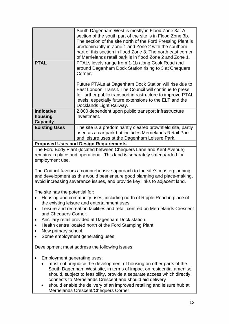
South Dagenham West is mostly in Flood Zone 3a. A section of the south part of the site is in Flood Zone 3b. The section of the site north of the Ford Pressing Plant is predominantly in Zone 1 and Zone 2 with the southern part of this section in flood Zone 3. The north east corner of Merrielands retail park is in flood Zone 2 and Zone 1.
PTAL PTALs levels range from 1-1b along Cook Road and around Dagenham Dock Station rising to 3 at Chequers Corner. Future PTALs at Dagenham Dock Station will rise due to East London Transit. The Council will continue to press for further public transport infrastructure to improve PTAL levels, especially future extensions to the ELT and the Docklands Light Railway.
Indicative housing Capacity
2,000 dependent upon public transport infrastructure investment.
Existing Uses The site is a predominantly cleared brownfield site, partly used as a car park but includes Merrielands Retail Park and leisure uses at the Dagenham Leisure Park.
Proposed Uses and Design Requirements The Ford Body Plant (located between Chequers Lane and Kent Avenue) remains in place and operational. This land is separately safeguarded for employment use. The Council favours a comprehensive approach to the site’s masterplanning and development as this would best ensure good planning and place-making, avoid increasing severance issues, and provide key links to adjacent land. The site has the potential for: Housing and community uses, including north of Ripple Road in place of
the existing leisure and entertainment uses. Leisure and recreation facilities and retail centred on Merrielands Crescent
and Chequers Corner. Ancillary retail provided at Dagenham Dock station. Health centre located north of the Ford Stamping Plant. New primary school. Some employment generating uses. Development must address the following issues: Employment generating uses:
must not prejudice the development of housing on other parts of the South Dagenham West site, in terms of impact on residential amenity; should, subject to feasibility, provide a separate access which directly connects to Merrielands Crescent and should aid delivery
should enable the delivery of an improved retailing and leisure hub at Merrielands Crescent/Chequers Corner
14
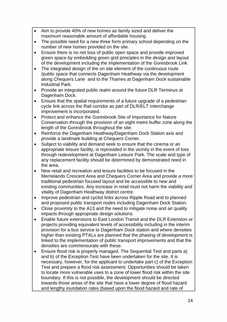
Aim to provide 40% of new homes as family sized and deliver the maximum reasonable amount of affordable housing.
The possible need for a new three form primary school depending on the number of new homes provided on the site.
Ensure there is no net loss of public open space and provide improved green space by embedding green grid principles in the design and layout of the development including the implementation of the Goresbrook Link.
The integrated design of the on site element of the continuous route /public space that connects Dagenham Heathway via the development along Chequers Lane and to the Thames at Dagenham Dock sustainable Industrial Park.
Provide an integrated public realm around the future DLR Terminus at Dagenham Dock.
Ensure that the spatial requirements of a future upgrade of a pedestrian cycle link across the Rail corridor as part of DLR/ELT Interchange improvement is incorporated.
Protect and enhance the Goresbrook Site of Importance for Nature Conservation through the provision of an eight metre buffer zone along the length of the Goresbrook throughout the site.
Reinforce the Dagenham Heathway/Dagenham Dock Station axis and provide a landmark building at Chequers Corner.
Subject to viability and demand seek to ensure that the cinema or an appropriate leisure facility, is reprovided in the vicinity in the event of loss through redevelopment at Dagenham Leisure Park. The scale and type of any replacement facility should be determined by demonstrated need in the area.
New retail and recreation and leisure facilities to be focused in the Merrielands Crescent Area and Chequers Corner Area and provide a more traditional pedestrian focused layout and be accessible to new and existing communities. Any increase in retail must not harm the viability and vitality of Dagenham Heathway district centre.
Improve pedestrian and cyclist links across Ripple Road and to planned and proposed public transport nodes including Dagenham Dock Station.
Close proximity to the A13 and the need to mitigate noise and air quality impacts through appropriate design solutions.
Enable future extensions to East London Transit and the DLR Extension or projects providing equivalent levels of accessibility including in the interim provision for a bus service to Dagenham Dock station and where densities higher than existing PTALs are planned that the phasing of development is linked to the implementation of public transport improvements and that the densities are commensurate with these.
Ensure flood risk is properly managed. The Sequential Test and parts a) and b) of the Exception Test have been undertaken for the site. It is necessary, however, for the applicant to undertake part c) of the Exception Test and prepare a flood risk assessment. Opportunities should be taken to locate more vulnerable uses to a zone of lower flood risk within the site boundary. If this is not possible, the development should be directed towards those areas of the site that have a lower degree of flood hazard and lengthy inundation rates (based upon the flood hazard and rate of
15
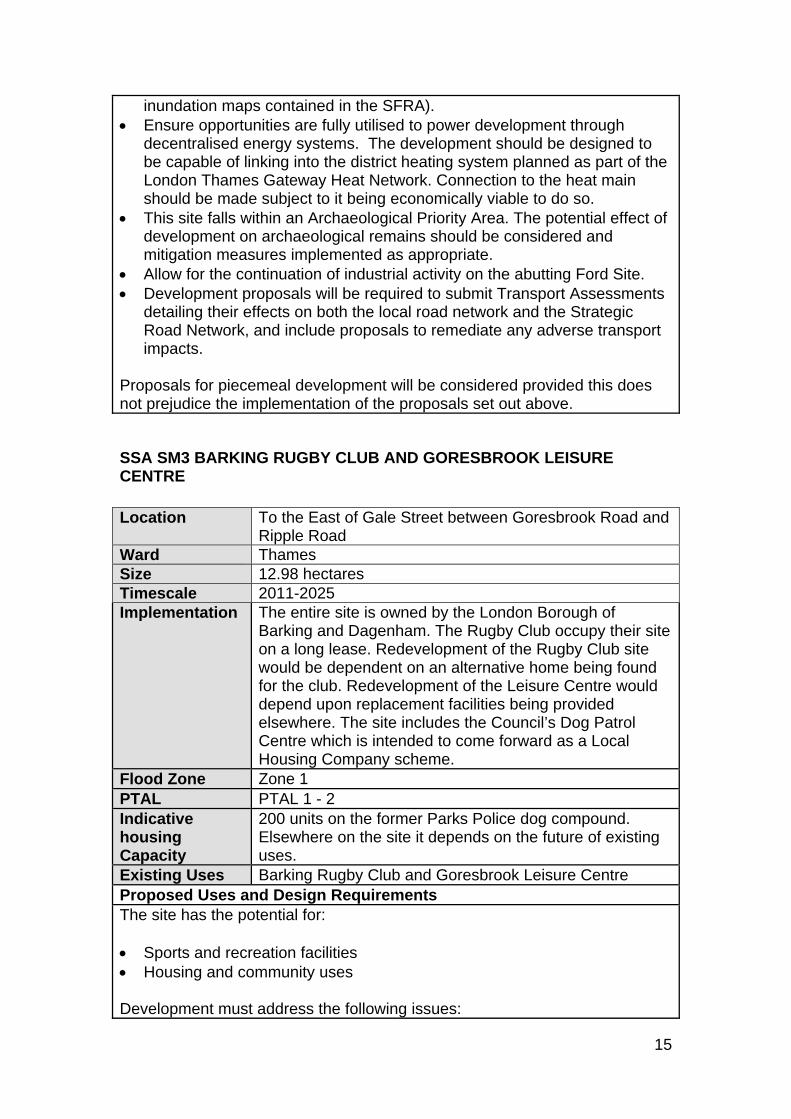
inundation maps contained in the SFRA). Ensure opportunities are fully utilised to power development through
decentralised energy systems. The development should be designed to be capable of linking into the district heating system planned as part of the London Thames Gateway Heat Network. Connection to the heat main should be made subject to it being economically viable to do so.
This site falls within an Archaeological Priority Area. The potential effect of development on archaeological remains should be considered and mitigation measures implemented as appropriate.
Allow for the continuation of industrial activity on the abutting Ford Site. Development proposals will be required to submit Transport Assessments
detailing their effects on both the local road network and the Strategic Road Network, and include proposals to remediate any adverse transport impacts.
Proposals for piecemeal development will be considered provided this does not prejudice the implementation of the proposals set out above.
SSA SM3 BARKING RUGBY CLUB AND GORESBROOK LEISURE CENTRE Location To the East of Gale Street between Goresbrook Road and
Ripple Road Ward Thames Size 12.98 hectares Timescale 2011-2025 Implementation The entire site is owned by the London Borough of
Barking and Dagenham. The Rugby Club occupy their site on a long lease. Redevelopment of the Rugby Club site would be dependent on an alternative home being found for the club. Redevelopment of the Leisure Centre would depend upon replacement facilities being provided elsewhere. The site includes the Council’s Dog Patrol Centre which is intended to come forward as a Local Housing Company scheme.
Flood Zone Zone 1 PTAL PTAL 1 - 2 Indicative housing Capacity
200 units on the former Parks Police dog compound. Elsewhere on the site it depends on the future of existing uses.
Existing Uses Barking Rugby Club and Goresbrook Leisure Centre Proposed Uses and Design Requirements The site has the potential for: Sports and recreation facilities Housing and community uses Development must address the following issues:
16
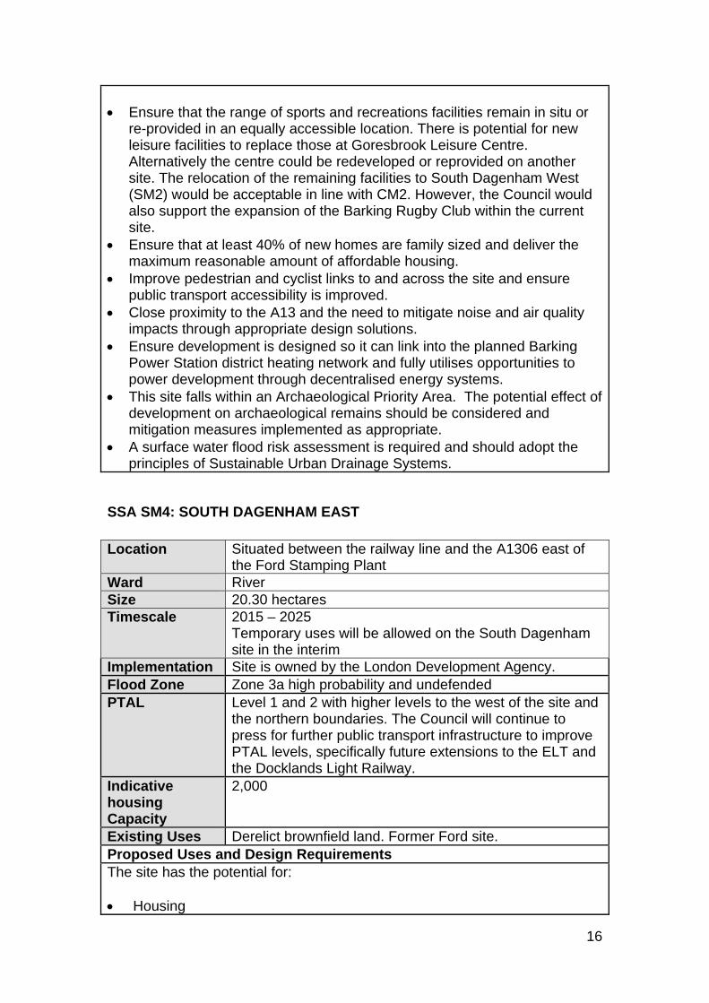
Ensure that the range of sports and recreations facilities remain in situ or
re-provided in an equally accessible location. There is potential for new leisure facilities to replace those at Goresbrook Leisure Centre. Alternatively the centre could be redeveloped or reprovided on another site. The relocation of the remaining facilities to South Dagenham West (SM2) would be acceptable in line with CM2. However, the Council would also support the expansion of the Barking Rugby Club within the current site.
Ensure that at least 40% of new homes are family sized and deliver the maximum reasonable amount of affordable housing.
Improve pedestrian and cyclist links to and across the site and ensure public transport accessibility is improved.
Close proximity to the A13 and the need to mitigate noise and air quality impacts through appropriate design solutions.
Ensure development is designed so it can link into the planned Barking Power Station district heating network and fully utilises opportunities to power development through decentralised energy systems.
This site falls within an Archaeological Priority Area. The potential effect of development on archaeological remains should be considered and mitigation measures implemented as appropriate.
A surface water flood risk assessment is required and should adopt the principles of Sustainable Urban Drainage Systems.
SSA SM4: SOUTH DAGENHAM EAST Location Situated between the railway line and the A1306 east of
the Ford Stamping Plant Ward River Size 20.30 hectares Timescale 2015 – 2025
Temporary uses will be allowed on the South Dagenham site in the interim
Implementation Site is owned by the London Development Agency. Flood Zone Zone 3a high probability and undefended PTAL Level 1 and 2 with higher levels to the west of the site and
the northern boundaries. The Council will continue to press for further public transport infrastructure to improve PTAL levels, specifically future extensions to the ELT and the Docklands Light Railway.
Indicative housing Capacity
2,000
Existing Uses Derelict brownfield land. Former Ford site. Proposed Uses and Design Requirements The site has the potential for: Housing
17
Health Education Use Car parking facilities for the Ford Pressing Plant Light Industrial on the Western side fronting Ford Due to the timing of public transport improvements this site is unlikely to be built out before 2015. In the interim, the site has potential for temporary uses provided that: They do not compromise the future development of the site as set out in
this allocation and if possible provide the conditions for its implementation. A satisfactory relationship with surrounding uses can be achieved. It assists with the regeneration of the South Dagenham Key Regeneration
Area. Development must address the following issues: Enable future implementation of public transport improvements such as
East London Transit 3 and where densities higher than existing PTALs are planned that the phasing of development is linked to the implementation of public transport improvements and that the densities are commensurate with these.
A need for a new three form primary school on this site triggered by the new housing proposed in this site allocation.
Need to recognise relationship to Havering part of regeneration area and the proximity of the site to the proposed Beam Reach station.
The need to mediate between residential development and the Ford site through the use of light industrial uses.
Ensure flood risk is properly managed. The Sequential Test and parts a) and b) of the Exception Test have been undertaken for the site. It is necessary, however, for the applicant to undertake part c) of the Exception Test and prepare a flood risk assessment. Opportunities should be taken to locate more vulnerable uses to a zone of lower flood risk within the site boundary. If this is not possible, the development should be directed towards those areas of the site that have a lower degree of flood hazard and lengthy inundation rates (based upon the flood hazard and rate of inundation maps contained in the SFRA).
Inclusion of a strategic Green Grid Green open space that can contribute to a sustainable urban drainage system for the new residential development. The inclusion of a water element could provide flood attenuation as well as a valuable recreational, ecological and environmental resource on a site abutted on two sides by infrastructure.
Improve pedestrian and cyclist links across Ripple Road and to planned and proposed public transport nodes including Dagenham Dock Station.
Close proximity to the A13 and the need to mitigate noise and air quality impacts through appropriate design solutions.
The site is contaminated and requires remediation prior to development. Ensure development is designed so it can link into the planned Barking
Power Station district heating network and fully utilises opportunities to power development through decentralised energy systems.
18
Address need to provide car parking for Ford employees. This site falls within an Archaeological Priority Area. The potential effect of
development on archaeological remains should be considered and mitigation measures implemented as appropriate.
Provide public open space to meet the needs of the new households in line with the standards in the Community Benefits SPD.
Development proposals will be required to submit Transport Assessments detailing their effects on both the local road network and the Strategic Road Network, and include proposals to remediate any adverse transport impacts.
SSA SM5: SANOFI AVENTIS SITE 2 Location Situated north east from the Dagenham East District Line
station. Ward Eastbrook Size 16.15 hectares Timescale 2010 - 2020 Implementation This site was formerly part of the Sanofi Locally Significant
Industrial Site referred to in Chapter 5. It has been released as part of this DPD. Sanofi Aventis have recently decided to cease operations across the whole of the site. The Council will work in partnership with Sanofi Aventis to bring forward a comprehensive masterplan for Sanofi Sites 1 and 2. This allocation deals with Sanofi Site 1, however Sanofi Site 2 will also become available in 2013.
Flood Zone Zone 1 (low probability) PTAL Level 1, 1b, 2 and 3 across the site with higher levels near
Rainham Road South where Dagenham East Station (district line) is.
Indicative housing Capacity
0 - 500 (depends on precise mix of uses)
Existing Uses Vacant site formerly used for pharmaceutical uses Proposed Uses and Design Requirements This former employment site has the potential for: Employment (B1, B2, B8) and in particular affordable space for small and
medium sized businesses Community uses Retail Health Facilities Education possibly including a construction college Leisure use A council depot Residential
19
Development must address the following issues: The need for a polyclinic (approximately 3,000 m2) at the western end of
the site with an active frontage to North Rainham Road. The possible need for a new three form primary school depending on the
number of new homes provided on this site. Provision of retail facilities to be small scale, in keeping with that provided
by a neighbourhood centre, and increased only to accommodate any additional demand arising from associated mixed use development and be located on the western part of the site with frontage onto Rainham Road South.
Provide a suitable setting for the Eastbrookend Country Park bordering the south and east of the site.
Development must be designed sensitively to take account of the adjacent Chase Nature Reserve and Eastbrookend Country Park which is a site of Metropolitan Importance (MO90) and the Mid-Beam Valley and Dagenham East Lake (BandD BI05) which is Grade I site of Metropolitan Importance.
Distribution of land uses throughout the site to reflect higher PTAL levels at the western boundaries of the site.
Mitigate noise and air quality impacts from the operating Sanofi Aventis employment site to the north of the site through appropriate design solutions.
Improve links between Eastbrook End Country Park and the Beam Valley. Pedestrian, road and cycle network throughout the site to reflect and
incorporate existing public footpaths running through the site. Potential to incorporate 530 – 586 Rainham Road South (which is Council
owned) where there is potential to redevelop the existing flats and garages.
As a former industrial site, it is likely this site is contaminated. Land remediation will be required prior to development.
The need to improve the junction of Reede Road with Rainham Road south.
A surface water flood risk assessment is required and should adopt the principles of Sustainable Urban Drainage Systems.
SSA SM6: UNIVERSITY OF EAST LONDON Location Situated north of Mayesbrook Park and south of
Longbridge Road. Ward Becontree Size 9.59 hectares Timescale 2009-2017 Implementation The site is currently owned by George Wimpey and
London and Quadrant Housing Trust. An outline planning application which Wimpey submitted in partnership with Quadrant Housing Trust has been approved. Demolition works underway 2008.
Flood Zone Predominantly in Zone 1
20
North western corner in Zone 3a PTAL Level 2 Indicative housing Capacity
1,000
Existing Uses Former campus for the University of East London Proposed Uses and Design Requirements This former University of East London site has the potential for: Residential Education Publicly accessible open space Development must address the following issues: A need for a three form primary school on this site triggered by both
existing and new housing proposed in this site allocation. Provide public open space to meet the needs of the new households in
line with the standards in the Community Benefits SPD. Need to incorporate open play space for new residential developments. Due to its architectural quality the main university building to be retained
in development scheme. Development involves demolition. Developers to maximise the recovery of
materials from the demolition site for reuse or recycling, by applying the Demolition Protocol Methodology.
Ensure flood risk is properly managed. The sequential test has been applied to this site allocation and has been passed. The developer will need to undertake a flood risk assessment.
Open space priorities for this site as set out in the Landscape Framework Plan adopted as part of the Urban Design Framework Supplementary Planning Document.
Improve pedestrian and cyclist links to and across the site and ensure public transport accessibility is improved to Barking Town Centre.
A surface water flood risk assessment is required and should adopt the principles of Sustainable Urban Drainage Systems.
21
SSA SM7: ROBIN HOOD PUBLIC HOUSE Location Situated north west from where Becontree Avenue meets
Longbridge Road Ward Becontree Size 0.41 hectares Timescale 2009-2012 Implementation LIDLs own the site and have permission (06/01230/FUL)
to erect a three storey development comprising a LIDLs food store on the ground floor with 12 two bedroom flats and 14 one bedroom flats together with associated landscaping, parking.
Flood Zone Zone 1 PTAL Level 2 Indicative housing Capacity
26 (Depends on extent of retail and other uses)
Existing Uses Vacant and former site of the Robin Hood public house. Proposed Uses and Design Requirements This site has the potential for a mixed use retail/residential development. The Council encourages a comprehensive development incorporating the adjacent site (SM20 Earls Walk Car Park). In line with BE2 principal retail access must be provided from active frontage along Longbridge Road so it compliments the existing retail parades which form the Robin Hood Neighbourhood Centre.
SSA SM8: LYMINGTON FIELDS Location Situated south of the Freshwater Road employment area. Ward Whalebone Size 12.68 hectares Timescale 2009-2016 Implementation The site is owned by the Homes and Communities
Agency. An outline planning application (07/01289/OUT) was submitted in 2007 for 602 dwellings and provision of land for new school and public open space. Detailed application for phase 1 submitted concurrently. The Homes and Communities Agency is developing the site in partnership with Countryside Properties.
Flood Zone Zone 1 PTAL Levels 1, 2 and 3 Indicative housing Capacity
600
Existing Uses Vacant site Proposed Uses and Design Requirements This site has the potential for:
22
Housing Retail Publicly accessible open space Education
Development must address the following issues:
Site is suitable for family housing and therefore the 40% borough wide family housing target applies.
Deliver the maximum reasonable amount of affordable housing. A new three form primary school must be incorporated into the scheme
due to existing and additional need arising from the proposed development.
Identified need for publicly accessible open space in this area. Noise sensitive uses to be avoided in close vicinity to the Freshwater
Road Locally Significant Employment site (northern border of the site). Noise sensitive uses to be avoided in close vicinity to the Chadwell
Heath Locally Significant Employment site (northern border in the western part of the site).
Improve pedestrian and cyclist links to and across the site and ensure public transport accessibility is improved.
Provide public open space to meet the needs of the new households in line with the standards in the Community Benefits SPD.
A surface water flood risk assessment is required and should adopt the principles of Sustainable Urban Drainage Systems and where possible achieve greenfield run-off rates.
SSA SM9: BEACONTREE HEATH – SEABROOK HALL Location Situated south east from where Wood Lane meets Green
Lane Ward Heath Size 0.53 hectares Timescale 2009 - 2012 Implementation The Council is the land owner and masterplanning the site
for the provision of a new leisure centre. A planning application will be submitted in early 2009. Development is expected to start during 2009 and completed by 2011.
Flood Zone Zone 1 PTAL Level 2 Indicative housing Capacity
0
Existing Uses Community Hall Proposed Uses and Design Requirements
23
This site has the potential for:
Leisure facilities Community use
Development must address the following issues:
Need to replace existing leisure facilities provided at the Dagenham Swimming Pool.
Loss of community hall (Seabrook Hall) space on this site. Need for a landmark building on this site due to prime location on a key
junction of Whalebone Lane South and the A1083 (Rainham Road North).
Development involves demolition. Developers to maximise the recovery of materials from the demolition site for reuse or recycling, by applying the Demolition Protocol Methodology.
SSA SM10: BEACONTREE HEATH – WIDER SITE Location Focused on the area around Althorne Way Ward Heath Size 4.14 hectares Timescale 2012 - 2017 Implementation The Council owns the existing Dagenham Leisure Centre,
Morrisons own the supermarket site. Once the new leisure centre is provided at the Seabrook Hall location, the existing Dagenham Swimming Pool will close and be available for redevelopment.
Flood Zone Zone 1 PTAL Level 2 Indicative housing Capacity
164. This is the capacity of the site once demolitions and the other uses allowed for by the policy have been taken into account.
Existing Uses Dagenham Leisure Centre, Morrisons supermarket, residential, bus depot, public house, off-street car parking and community facilities.
Proposed Uses and Design Requirements This site has the potential for:
Housing Retail Health facilities Bus standing facilities
Development must address the following issues:
Identified need for improved health facility (1000-2000 m2).
24
Site is suitable for family housing and therefore the 40% borough wide family housing target must be met.
Deliver the maximum reasonable amount of affordable housing. Any net increase in retail provision on this site will need to satisfy
Borough Wide Development Policy BE3. Improve pedestrian and cyclist links across both Whalebone Lane South
and Rainham Road North to allow easy access, safe and attractive access to future community hub.
Residential density levels must reflect that this is an urban location with existing low PTAL levels. Any density increases beyond this will need to be tied in with public transport improvements.
The possible need to provide car parking to support SM9 with satisfactory entrance and exit arrangements.
Development involves demolition. Developers to maximise the recovery of materials from the demolition site for reuse or recycling, by applying the Demolition Protocol Methodology.
Take account of the locally listed status of the Three Travellers Pub. A surface water flood risk assessment is required and should adopt the
principles of Sustainable Urban Drainage Systems and where possible achieve greenfield run-off rates.
The site currently provides a bus terminus and bus standing facilities. In the event of needing to relocate these, the developer must meet the requirements of Policy 3C.4 of the London Plan and the Land for Transport SPG.
SSA SM11: HEDGECOCK CENTRE Location Situated west from where Upney Lane meets the District
Line Ward Longbridge Size 1.09 hectares Timescale 2010-2012 Implementation The site is owned by the North East London NHS
Foundation Trust. This centre may become surplus to requirements due to the planned improvements to Barking Hospital and the planned new Julia Engwell Clinic (SC8).
Flood Zone Zone 1 PTAL Levels 2 and 3 Indicative Capacity
60
Existing Uses Operating hospital site for North East London NHS Foundation Trust (NELFT). Includes mental health facilities.
Proposed Uses and Design Requirements This site has the potential for:
25
Health facilities Residential
Development must address the following issues:
Site is suitable for family housing and therefore the 40% borough wide family housing target must be met.
Deliver the maximum reasonable amount of affordable housing. An access road runs around the site providing access from Upney Lane
to the hospital. Any proposed development scheme must demonstrate that noise, visual and road safety impacts are managed and mitigated appropriately through design solutions.
This site falls within an Archaeological Priority Area. The potential effect of development on archaeological remains should be considered and mitigation measures implemented as appropriate.
The need to retain and enhance the existing conservation value of existing mature trees currently located along the southern and south east boundary of the site some of which are covered by Tree Preservation Orders.
Noise sensitive uses to be avoided in close vicinity to the railway line. Improve pedestrian and cyclist links to and across the site.
SSA SM12: UPNEY LANE CENTRE Location North of Champness Road Ward Longbridge Size 0.43 hectares Timescale 2010-2012 Implementation The site is owned by Barking, Havering and Redbridge
University Hospitals NHS Trust. Due to improvements and upgrading of facilities taking place at Barking Hospital and following improvements in health care facilities across the borough the Upney Lane Centre may be identified as being surplus to present healthcare requirements.
Flood Zone Predominantly in Zone 1 with the eastern corner being in Zone 2
PTAL Level 2 Indicative Capacity
25
Proposed Uses and Design Requirements This site has the potential for:
Residential and community facilities Health facilities
Development must address the following issues:
26
Site is suitable for family housing and therefore the 40% borough wide family housing target must be met.
Deliver the maximum reasonable amount of affordable housing. The proposed development scheme will not result in an adverse impact
on provision of health facilities in the local community. Improve pedestrian and cyclist links to and across the site. Ensure flood risk is properly managed. The Sequential Test and parts a)
and b) of the Exception Test have been undertaken for the site. It is necessary, however, for the applicant to undertake part c) of the Exception Test and prepare a flood risk assessment. Opportunities should be taken to locate more vulnerable uses to a zone of lower flood risk within the site boundary. If this is not possible, the development should be directed towards those areas of the site that have a lower degree of flood hazard and lengthy inundation rates (based upon the flood hazard and rate of inundation maps contained in the SFRA).
SSA SM13: THAMES VIEW REGENERATION SITES Location Eastern End of Thames View Regeneration Area (5.09)
Farr Avenue Shops (0.48) Alderman Avenue Garages (0.32) Charlton Crescent Garages site 1 (0.12) Charlton Crescent Garages site 2 (0.21) Chelmer Crescent Garages (0.31) Curzon Crescent Garages (0.52) Roycraft Avenue (0.24) Garage site to the rear of 75 – 77 Wivenhoe Road (0.09)
Ward Thames Size See above Timescale 2010 – 2015 Implementation The Council owns the land and is planning on bringing
these sites forward for redevelopment through the Local Housing Company. A Masterplan completed in 2009, forms the basis of development coming forward on this site.
Flood Zone Zone 3a PTAL Level 1b
East London Transit Phase 1 already committed will bring this up to Level 2.
Indicative housing Capacity
500. This is the capacity of the sites which comprise this policy as demonstrated by the Thames View Masterplan. The majority of this capacity will be on the Eastern End of Thames View site
Existing Uses Housing, garages and retail Proposed Uses and Design Requirements
27
These sites have the potential for:
Eastern End of Thames View – comprehensive redevelopment replacing existing uses including housing, community and open spaces.
Farr Avenue Shops – improvement of public realm and provision of A1 retail units facing Bastable Avenue including the retention of police use at 2 Farr Avenue.
Alderman Avenue Garages, Charlton Crescent Garages site 2, Chelmer Crescent Garages, Curzon Crescent Garages and Roycraft Avenue Garages and Garage site to the rear of 75 – 77 Wivenhoe Road, – infill housing developments.
Charlton Crescent Garages Site – public open space or housing development linked to longer term plan for a gateway feature in this area.
Development must address the following issues:
Improvement of the public realm around the Farr Avenue shops to improve vitality and viability through appropriate design and layout providing an attractive community hub. Retail to be retained at ground floor level. Retail frontage to be provided facing Bastable Avenue and these prime units to be designated A1 use.
The housing sites are suitable for family housing and therefore the 40% minimum borough wide family housing target must be met.
Eastern End of Thames View Regeneration - deliver the maximum reasonable amount of affordable housing ensuring no net loss of existing affordable housing.
Infill sites – deliver the maximum reasonable amount of affordable housing.
Some sites involve demolition. Developers to maximise the recovery of materials from the demolition site for reuse or recycling, by applying the Demolition Protocol Methodology.
Residential density levels must reflect that the estate is an urban location with existing low PTAL levels. Any density increases beyond this will need to be tied in with the implementation of the East London Transit which will be routed along Bastable Avenue.
Ensure flood risk is properly managed. The Sequential Test and parts a) and b) of the Exception Test have been undertaken for these sites. It is necessary, however, for the applicant to undertake part c) of the Exception Test and prepare a flood risk assessment. Opportunities should be taken to locate more vulnerable uses to a zone of lower flood risk within the site boundary. If this is not possible, the development should be directed towards those areas of the site that have a lower degree of flood hazard and lengthy inundation rates (based upon the flood hazard and rate of inundation maps contained in the SFRA).
Ensure existing nature conservation value at Chelmer Crescent Garages is retained, enhanced and maintained through incorporation of nature conservation features in the detailed designs for the development of this site.
Development of garages sites to be subject to sufficient vehicular and
28
pedestrian access being achieved. Proposals must be in line with the approved Masterplan which is currently
being developed for this site. The garage sites at Curzon Crescent, Chelmer Crescent and Charlton
Crescent at the time of writing were still in use. Any development proposal would need to demonstrate that there is no longer a requirement for these garages to be available for local residents and that there will be no adverse impact on on-street parking in the local area. Applicants should contact the Council for up to date information on garage usage. The development of these sites must meet the criteria in paragraph 2.9.
Pedestrian and cyclist routes to be designed to facilitate ease of and safe movement throughout the site particularly with regard to accessing the community hub at Farr Avenue shops from redeveloped residential schemes and improving links between the Thames View Estate, Barking Town Centre and Barking Riverside including access to new open spaces.
Improve pedestrian and cycle links to and across the site towards surrounding communities east of Renwick Road and towards Barking Riverside development.
Improve relationship of Estate with surrounding area by improving access and visibility arrangements to Bastable Avenue from Renwick Road and from River Road.
Proposed development scheme at the Eastern End should complement the proposed junction improvements to the A13 and the upgrade of the rail crossing.
Development proposals will be required to submit Transport Assessments detailing their effects on both the local road network and the Strategic Road Network, and include proposals to remediate any adverse transport impacts.
The sites fall within an Archaeological Priority Area. The potential effect of redevelopment on archaeology remains should be considered and appropriate mitigation measures implemented.
SSA SM14: MARK’S GATE REGENERATION SITES Location Padnall Court and Reynolds Court (3.29)
Padnall Hall, Gregory Road (0.16) Rose Lane Garages (0.09) Rose Lane site of former WC (0.17) Roles Grove Garages (0.20) Land at St Mark’s Church, Arneways Avenue (0.33)
Ward Chadwell Heath Size See above Timescale 2010 – 2015 Implementation The Council owns the land and is planning on bringing
these sites forward for redevelopment through the Local
29
Housing Company. A Masterplan will be prepared for the whole of the Marks Gate Estate.
Flood Zone Zone 1 PTAL Levels 1 and 2 Indicative housing Capacity
157. This is the capacity of the sites which comprise this policy once the demolition of Padnall Court and Reynolds Court is taken into account. The majority of this capacity will be provided on the Padnall Court and Reynolds Court sites.
Existing Uses Housing, community hall and garages Proposed Uses and Design Requirements This site has the potential for: Padnall Court and Reynolds Court – comprehensive redevelopment
replacing existing uses including housing and open space providing a net gain in housing units.
Padnall Hall, Gregory Road – replacement and improvement of existing community facilities.
Rose Lane Garages – infill housing development. Rose Lane site of former WC – infill housing development. Roles Grove Garages – infill housing development. Land at St Mark’s Church, Arneways Avenue - comprehensive
redevelopment replacing existing community use as a religious meeting place and incorporating open space and residential use.
Redevelopment must address the following issues: Although this is a suburban location with existing low PTAL levels higher
densities may be acceptable to enable a successful redevelopment which provides better quality housing.
Deliver the maximum reasonable amount of affordable housing and ensure no net loss of existing affordable housing
The housing sites are suitable for family housing and therefore the 40% minimum borough wide family housing target must be met
These proposals will involve decanting residents from Padnall and Reynolds Court. Due to limited opportunities it may be necessary to use the Mark’s Gate allotment site for this purpose. This is a statutory allotment site and is designated protected open space and there is an identified shortage of operating allotment land in the Mark’s Gate area (see Chapter 3). The currently disused and vacant allotment site is in need of substantial qualitative improvements thus deterring potential allotment holders. There is a need to bring good quality and accessible allotment plots back into use as part of a comprehensive redevelopment scheme across this regeneration site. Any proposals to relocate this allotment provision needs to be done within the Mark’s Gate area and in consultation with local allotment associations. Because this is a statutory site, any proposals to relocate it will have to be done in consultation with the Government Office for London and the National Society of Allotment and Leisure Gardeners.
30
Proposals must be in line with the approved Masterplan which is currently being developed for this site.
Address the existing nature conservation value of sites, particularly the Mark’s Gate allotment site and the land adjacent to the Mark’s Gate allotment site (currently used as grazing land by the Wellgate Community Farm). The sequential approach set out in Borough Wide Policy BR3 needs to be followed should these sites be affected by development.
The need for improved community facilities and the problems associated with young people not having enough places to go in Mark’s Gate as identified during public consultation on the Site Specific Allocations policies.
The value the local community attach to the currently under-used community space at Padnall Hall.
The garage sites at Rose Lane and Roles Grove at the time of writing were still in use. Any development proposal would need to demonstrate that there is no longer a requirement for these garages to be available for local residents and that there will be no adverse impact on on-street parking in the local area. Applicants should contact the Council for up to date information on garage usage. The development of these sites must meet the criteria in paragraph 2.9.
The Rose Lane former WC site is adjacent to Rose Lane neighbourhood centre as identified on the Proposals Map. Any development scheme will be required to provide an active frontage at ground floor on Rose Lane (Policy BE2: Development in Town Centres). The biodiversity and amenity value of the green verge to Roles Grove needs to be addressed in line with Policy BR3.
The existing community value of the Land adjacent to Mark’s Gate allotments. This land is currently open and valued as important grazing land for Wellgate Community Farm.
Improve pedestrian and cyclist links to and across the site and ensure public transport accessibility is improved.
A surface water flood risk assessment is required and should adopt the principles of Sustainable Urban Drainage Systems and where possible achieve greenfield run-off rates. The Level 2 SFRA for the borough specifically mentions a recommendation to incorporate SUDS on this site.
SSA SM15: GORESBROOK VILLAGE Location Situated west of Castle Green Park Ward Thames Size 2.81 hectares Timescale 2015 – 2020 Implementation The site is owned by the Council. This site has been
identified as an Estate Renewal Project to be undertaken by the Local Housing Company.
31
Flood Zone Zone 1 PTAL Level 1b Indicative Capacity
250
Existing Uses Existing council housing blocks Proposed Uses and Design Requirements This site is suitable for the following uses:
Housing with supporting social infrastructure, community facilities and amenity space.
Development must address the following issues: Although this is a suburban location with existing low PTAL levels higher
densities may be acceptable to enable a successful redevelopment which provides better quality housing.
Deliver the maximum reasonable amount of affordable housing and ensure no net loss of existing affordable housing.
This site is suitable for family housing and therefore the 40% minimum borough wide family housing target must be met.
The phasing of the site must make provision for the decanting of residents during its redevelopment.
Close proximity to the A13 and the need to mitigate noise and air quality impacts through appropriate design solutions.
Design and layout of a new development scheme should be sensitive to the site being adjacent to an important public open space, Castle Green Park. Any new developments scheme should contribute positively to the local landscape.
Any proposed development should complement the proposed junction improvements to the A13 at Renwick Road.
Any proposed development scheme should complement the proposed new north-south route linking Castle Green Park to the Thames frontage at Barking Riverside as identified in the London Riverside Area Framework, East London Green Grid, SPG to the London Plan.
A surface water flood risk assessment is required and should adopt the principles of Sustainable Urban Drainage Systems and where possible achieve greenfield run-off rates.
Minor Housing Sites 2.14 The following sites, as shown on the Proposals Map, are considered to
be potentially suitable for housing subject to the relevant Core Strategy Policies and Borough Wide Development Policies being satisfied. Therefore developments must:
Be built to high standards of sustainable design and construction
(BR1) Minimise CO2 emissions (BR2)
32
Apply the sequential approach to preserving and enhancing the natural environment (BR3)
Provide adequate parking (BR9). Many of these sites are within existing residential areas which are already suffering from on-street car parking pressures. Therefore new development should seek to provide the required amount of car parking within its curtilage
Be designed around the needs of pedestrians and cyclists (BR11)
Mitigate noise (BR13) Not cause a breach of air quality standards (BR14) For sites above 9 units deliver the maximum reasonable amount
of affordable housing Provide new homes to Lifetime Home standard and incorporate
a proportion of superflexible housing (BC2) Take account of Secured by Design principles and practices
(BC7) Where relevant address heritage and archaeological issues
(BP2 and BP3) Provide appropriate levels of external and/or communal amenity
space (BP5) Provide adequate internal space (BP6) Many of these minor housing sites are surrounded by existing
housing and therefore it is essential that existing residential amenity is protected including avoiding significant overlooking or overshadowing of neighbouring properties and minimising general disturbance arising from the development (BP8)
Achieve densities in line with the London Plan density matrix (BP10)
Achieve a high standard of urban design. (BP11) The Council will assess all schemes of ten or more new homes against the Building for Life standard
2.15 Where there are particular issues that need to addressed, these are
identified for each site. Most of these sites are in the heart of established residential areas. Therefore applicants, where appropriate, must undertake pre-application consultation through the relevant Neighbourhood Management Group. The Council intends to prepare development briefs for particularly sensitive sites and will seek the input of the Council’s Residents Urban Design Forum in formulating these. The Council will also expect all new housing schemes of 10 units or over to address the Building for Life assessment criteria.
2.16 Chapter 3 covers the sites which have been identified for essential
community facilities. However the development of essential community facilities necessary to meet the identified needs of the community will be allowed on the following sites where appropriate.
33
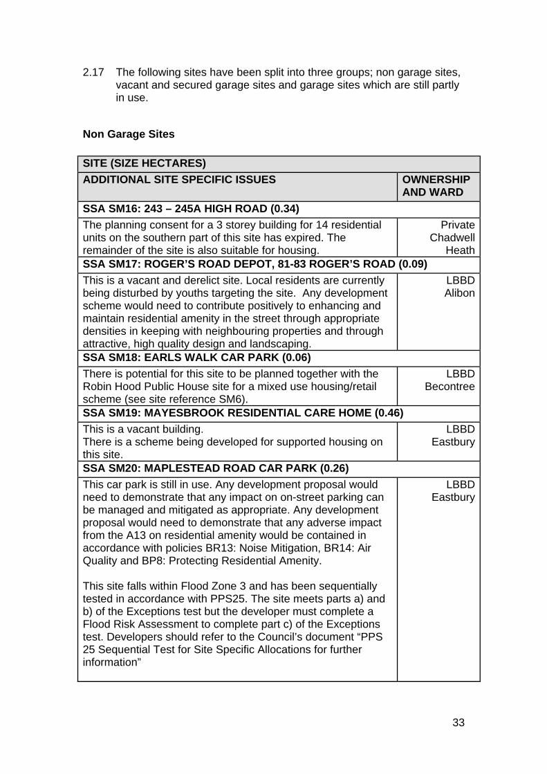
2.17 The following sites have been split into three groups; non garage sites, vacant and secured garage sites and garage sites which are still partly in use.
Non Garage Sites SITE (SIZE HECTARES)
ADDITIONAL SITE SPECIFIC ISSUES OWNERSHIP AND WARD
SSA SM16: 243 – 245A HIGH ROAD (0.34)
The planning consent for a 3 storey building for 14 residential units on the southern part of this site has expired. The remainder of the site is also suitable for housing.
PrivateChadwell
HeathSSA SM17: ROGER’S ROAD DEPOT, 81-83 ROGER’S ROAD (0.09)
This is a vacant and derelict site. Local residents are currently being disturbed by youths targeting the site. Any development scheme would need to contribute positively to enhancing and maintain residential amenity in the street through appropriate densities in keeping with neighbouring properties and through attractive, high quality design and landscaping.
LBBDAlibon
SSA SM18: EARLS WALK CAR PARK (0.06)
There is potential for this site to be planned together with the Robin Hood Public House site for a mixed use housing/retail scheme (see site reference SM6).
LBBDBecontree
SSA SM19: MAYESBROOK RESIDENTIAL CARE HOME (0.46)
This is a vacant building. There is a scheme being developed for supported housing on this site.
LBBDEastbury
SSA SM20: MAPLESTEAD ROAD CAR PARK (0.26)
This car park is still in use. Any development proposal would need to demonstrate that any impact on on-street parking can be managed and mitigated as appropriate. Any development proposal would need to demonstrate that any adverse impact from the A13 on residential amenity would be contained in accordance with policies BR13: Noise Mitigation, BR14: Air Quality and BP8: Protecting Residential Amenity. This site falls within Flood Zone 3 and has been sequentially tested in accordance with PPS25. The site meets parts a) and b) of the Exceptions test but the developer must complete a Flood Risk Assessment to complete part c) of the Exceptions test. Developers should refer to the Council’s document “PPS 25 Sequential Test for Site Specific Allocations for further information”
LBBDEastbury
34
SSA SM21: LAND ADJACENT TO 1A ESSEX ROAD (0.06)
This site is currently being used unofficially for vehicle parking. In line with Policy BR9 any impact on on-street parking must be addressed. The previous outline planning application granted for the site has lapsed.
LBBDGascoigne
SSA SM22: 135 BROMHALL ROAD DEPOT AND SURGERY (0.09)
This site is no longer needed by the PCT for health facilities. LBBDMayesbrook
Vacant Garage Sites 2.18 These garage sites are vacant, secured and no longer needed for
residential off-street parking. SITE (SIZE HECTARES)
ADDITIONAL SITE SPECIFIC ISSUES OWNERSHIP AND WARD
SSA SM23: GARAGES REAR OF 289-309 HEATHWAY (0.11)
This site has existing planning consent 07/01354/FUL for demolition of garages and erection of 2 storey block comprising 10 1 and 2 bedroom flats and associated landscaping and cycle store.
PrivateAlibon
SSA SM24: BURFORD CLOSE GARAGES (0.12)
Although these garages are not in use, two are privately owned.
LBBDBecontree
SSA SM25: BEAMWAY GARAGES (0.09)
The site borders the Green Belt and a Site of Importance for Nature Conservation as well as areas of high flood risk (Zone 2 and 3b). Any development scheme will be expected to be designed sensitively to ensure visual amenity of the openness of the Green Belt is not compromised (PPG2) and to demonstrate no negative impact on nature conservation value of the adjacent site as well as retain and enhance features of nature conservation value on the site (Policy BR3).
LBBDVillage
SSA SM26: GARAGES TO REAR OF 53-57 WELLINGTON DRIVE (0.14)
No additional site specific issues. LBBDVillage
SSA SM27: 58-62 CHURCH STREET (0.10)
There is potential for a wider development incorporating 64-68 Church Street which is owned by the Council.
PrivateVillage
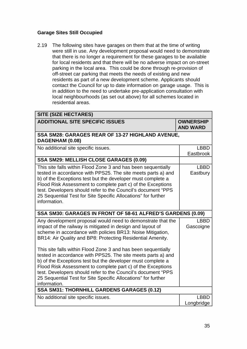
35
Garage Sites Still Occupied 2.19 The following sites have garages on them that at the time of writing
were still in use. Any development proposal would need to demonstrate that there is no longer a requirement for these garages to be available for local residents and that there will be no adverse impact on on-street parking in the local area. This could be done through re-provision of off-street car parking that meets the needs of existing and new residents as part of a new development scheme. Applicants should contact the Council for up to date information on garage usage. This is in addition to the need to undertake pre-application consultation with local neighbourhoods (as set out above) for all schemes located in residential areas.
SITE (SIZE HECTARES)
ADDITIONAL SITE SPECIFIC ISSUES OWNERSHIP AND WARD
SSA SM28: GARAGES REAR OF 13-27 HIGHLAND AVENUE, DAGENHAM (0.08)
No additional site specific issues. LBBDEastbrook
SSA SM29: MELLISH CLOSE GARAGES (0.09)
This site falls within Flood Zone 3 and has been sequentially tested in accordance with PPS25. The site meets parts a) and b) of the Exceptions test but the developer must complete a Flood Risk Assessment to complete part c) of the Exceptions test. Developers should refer to the Council’s document “PPS 25 Sequential Test for Site Specific Allocations” for further information.
LBBDEastbury
SSA SM30: GARAGES IN FRONT OF 58-61 ALFRED’S GARDENS (0.09)
Any development proposal would need to demonstrate that the impact of the railway is mitigated in design and layout of scheme in accordance with policies BR13: Noise Mitigation, BR14: Air Quality and BP8: Protecting Residential Amenity. This site falls within Flood Zone 3 and has been sequentially tested in accordance with PPS25. The site meets parts a) and b) of the Exceptions test but the developer must complete a Flood Risk Assessment to complete part c) of the Exceptions test. Developers should refer to the Council’s document “PPS 25 Sequential Test for Site Specific Allocations” for further information.
LBBDGascoigne
SSA SM31: THORNHILL GARDENS GARAGES (0.12)
No additional site specific issues. LBBDLongbridge
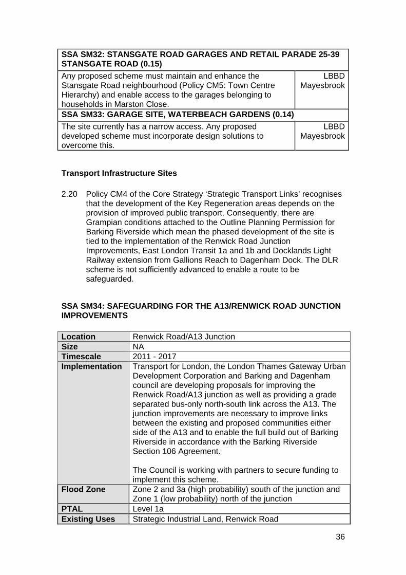
36
SSA SM32: STANSGATE ROAD GARAGES AND RETAIL PARADE 25-39 STANSGATE ROAD (0.15)
Any proposed scheme must maintain and enhance the Stansgate Road neighbourhood (Policy CM5: Town Centre Hierarchy) and enable access to the garages belonging to households in Marston Close.
LBBDMayesbrook
SSA SM33: GARAGE SITE, WATERBEACH GARDENS (0.14)
The site currently has a narrow access. Any proposed developed scheme must incorporate design solutions to overcome this.
LBBDMayesbrook
Transport Infrastructure Sites 2.20 Policy CM4 of the Core Strategy ‘Strategic Transport Links’ recognises
that the development of the Key Regeneration areas depends on the provision of improved public transport. Consequently, there are Grampian conditions attached to the Outline Planning Permission for Barking Riverside which mean the phased development of the site is tied to the implementation of the Renwick Road Junction Improvements, East London Transit 1a and 1b and Docklands Light Railway extension from Gallions Reach to Dagenham Dock. The DLR scheme is not sufficiently advanced to enable a route to be safeguarded.
SSA SM34: SAFEGUARDING FOR THE A13/RENWICK ROAD JUNCTION IMPROVEMENTS Location Renwick Road/A13 Junction Size NA Timescale 2011 - 2017 Implementation Transport for London, the London Thames Gateway Urban
Development Corporation and Barking and Dagenham council are developing proposals for improving the Renwick Road/A13 junction as well as providing a grade separated bus-only north-south link across the A13. The junction improvements are necessary to improve links between the existing and proposed communities either side of the A13 and to enable the full build out of Barking Riverside in accordance with the Barking Riverside Section 106 Agreement. The Council is working with partners to secure funding to implement this scheme.
Flood Zone Zone 2 and 3a (high probability) south of the junction and Zone 1 (low probability) north of the junction
PTAL Level 1a Existing Uses Strategic Industrial Land, Renwick Road
37
Proposed Uses and Design Requirements Improvements to the Renwick Road junction are necessary to integrate and connect existing and future communities on either side of the A13, to support the proposed plans for Barking Riverside and also to assist with new development proposed at Thames View. The following issues must be addressed: Need to provide a short term improvement by removing the right turn into
Renwick Road from the A13. Replacement of the existing at-grade junction in the longer term with a
grade separated junction enabling the removal of traffic light controls on the A13.
Need to provide a link road from Renwick Road to Lodge Avenue as part of the improvements. This will enable private vehicles generated by Barking Riverside to access and travel east or west on the A13 via the Lodge Avenue Roundabout and will also improve access to the adjacent employment uses.
Need to improve north-south public transport services through a bus service across the A13 to Becontree Station, or potentially an ELT link between Thames View and Barking Riverside through the Goresbrook Area to South Dagenham.
Need to provide a modern, safer, more efficient local road access for the whole area for pedestrians, cyclists, buses and car-borne traffic.
Need to improve capacity sufficiently to unlock the full housing potential of Barking Riverside (without the full A13RR Grade Separated Scheme Barking Riverside is capped at 3,999 homes occupied in accordance with the terms of the Section 106 Agreement).
Need to provide a functional and attractive gateway to the Barking Riverside development for all road users.
Need to minimise impact on Castle Green Park. Minimise its impact on the Sites of Importance for Nature Conservation; the
Goresbrook and the Ship and Shovel (Borough Importance Grade I) and the Mayesbrook and associated watercourses (Site of Borough Importance Grade II).
The current condition of the Renwick Road (Box Lane) Rail Bridge. This site falls within an Archaeological Priority Area. The potential effect of
development on archaeological remains should be considered and mitigation measures implemented as appropriate.
SSA SM35: FREIGHT INFRASTRUCTURE AT RENWICK ROAD/RIPPLE ROAD Location Area surrounding the Renwick Road/Ripple Road
interchange Ward Eastbury, Goresbrook and Thames Size 32.72 hectares Timescale Post 2012
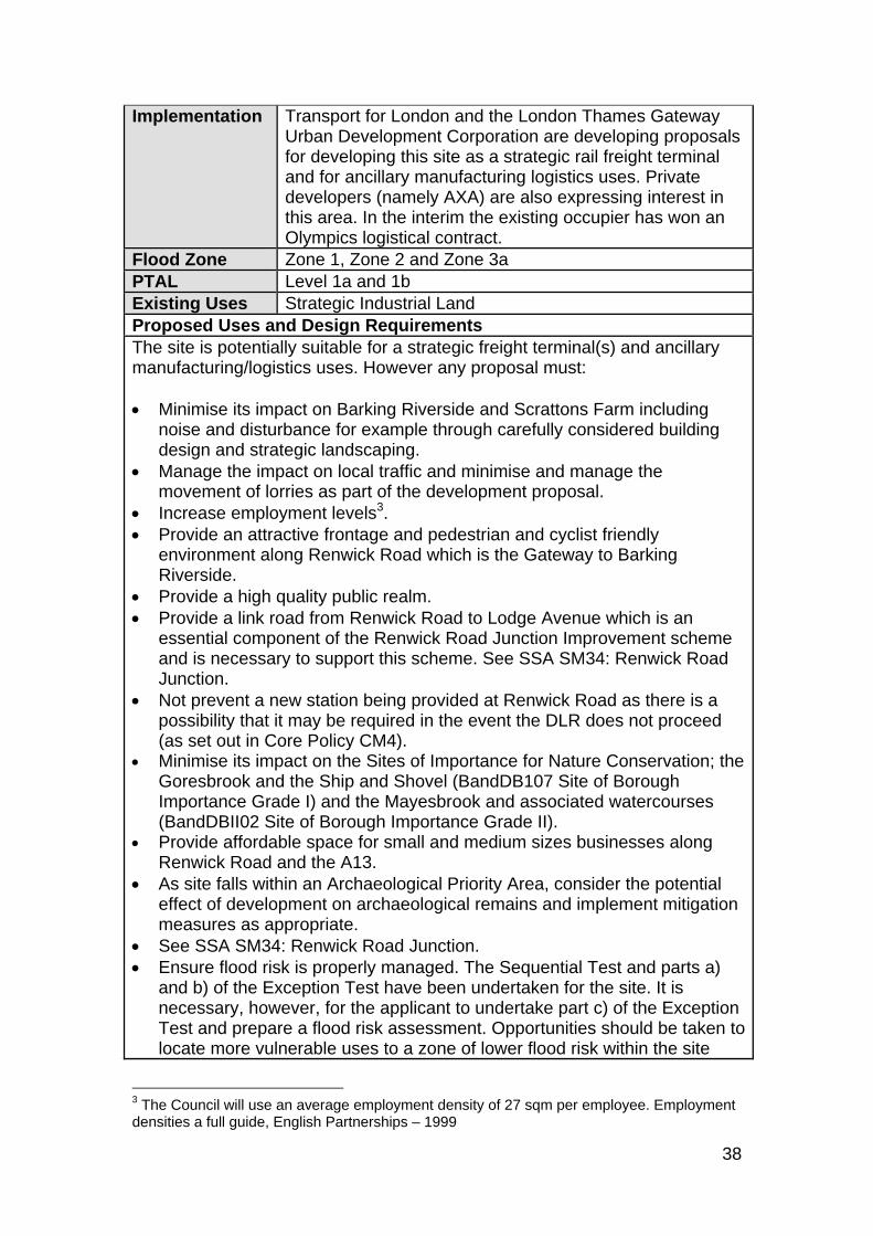
38
Implementation Transport for London and the London Thames Gateway Urban Development Corporation are developing proposals for developing this site as a strategic rail freight terminal and for ancillary manufacturing logistics uses. Private developers (namely AXA) are also expressing interest in this area. In the interim the existing occupier has won an Olympics logistical contract.
Flood Zone Zone 1, Zone 2 and Zone 3a PTAL Level 1a and 1b Existing Uses Strategic Industrial Land Proposed Uses and Design Requirements The site is potentially suitable for a strategic freight terminal(s) and ancillary manufacturing/logistics uses. However any proposal must: Minimise its impact on Barking Riverside and Scrattons Farm including
noise and disturbance for example through carefully considered building design and strategic landscaping.
Manage the impact on local traffic and minimise and manage the movement of lorries as part of the development proposal.
Increase employment levels3. Provide an attractive frontage and pedestrian and cyclist friendly
environment along Renwick Road which is the Gateway to Barking Riverside.
Provide a high quality public realm. Provide a link road from Renwick Road to Lodge Avenue which is an
essential component of the Renwick Road Junction Improvement scheme and is necessary to support this scheme. See SSA SM34: Renwick Road Junction.
Not prevent a new station being provided at Renwick Road as there is a possibility that it may be required in the event the DLR does not proceed (as set out in Core Policy CM4).
Minimise its impact on the Sites of Importance for Nature Conservation; the Goresbrook and the Ship and Shovel (BandDB107 Site of Borough Importance Grade I) and the Mayesbrook and associated watercourses (BandDBII02 Site of Borough Importance Grade II).
Provide affordable space for small and medium sizes businesses along Renwick Road and the A13.
As site falls within an Archaeological Priority Area, consider the potential effect of development on archaeological remains and implement mitigation measures as appropriate.
See SSA SM34: Renwick Road Junction. Ensure flood risk is properly managed. The Sequential Test and parts a)
and b) of the Exception Test have been undertaken for the site. It is necessary, however, for the applicant to undertake part c) of the Exception Test and prepare a flood risk assessment. Opportunities should be taken to locate more vulnerable uses to a zone of lower flood risk within the site
3 The Council will use an average employment density of 27 sqm per employee. Employment densities a full guide, English Partnerships – 1999
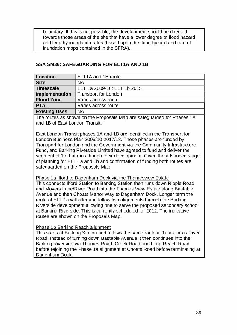
39
boundary. If this is not possible, the development should be directed towards those areas of the site that have a lower degree of flood hazard and lengthy inundation rates (based upon the flood hazard and rate of inundation maps contained in the SFRA).
SSA SM36: SAFEGUARDING FOR ELT1A AND 1B Location ELT1A and 1B route Size NA Timescale ELT 1a 2009-10; ELT 1b 2015 Implementation Transport for London Flood Zone Varies across route PTAL Varies across route Existing Uses NA The routes as shown on the Proposals Map are safeguarded for Phases 1A and 1B of East London Transit. East London Transit phases 1A and 1B are identified in the Transport for London Business Plan 2009/10-2017/18. These phases are funded by Transport for London and the Government via the Community Infrastructure Fund, and Barking Riverside Limited have agreed to fund and deliver the segment of 1b that runs though their development. Given the advanced stage of planning for ELT 1a and 1b and confirmation of funding both routes are safeguarded on the Proposals Map. Phase 1a Ilford to Dagenham Dock via the Thamesview Estate This connects Ilford Station to Barking Station then runs down Ripple Road and Movers Lane/River Road into the Thames View Estate along Bastable Avenue and then Choats Manor Way to Dagenham Dock. Longer term the route of ELT 1a will alter and follow two alignments through the Barking Riverside development allowing one to serve the proposed secondary school at Barking Riverside. This is currently scheduled for 2012. The indicative routes are shown on the Proposals Map. Phase 1b Barking Reach alignment This starts at Barking Station and follows the same route at 1a as far as River Road. Instead of turning down Bastable Avenue it then continues into the Barking Riverside via Thames Road, Creek Road and Long Reach Road before rejoining the Phase 1a alignment at Choats Road before terminating at Dagenham Dock.
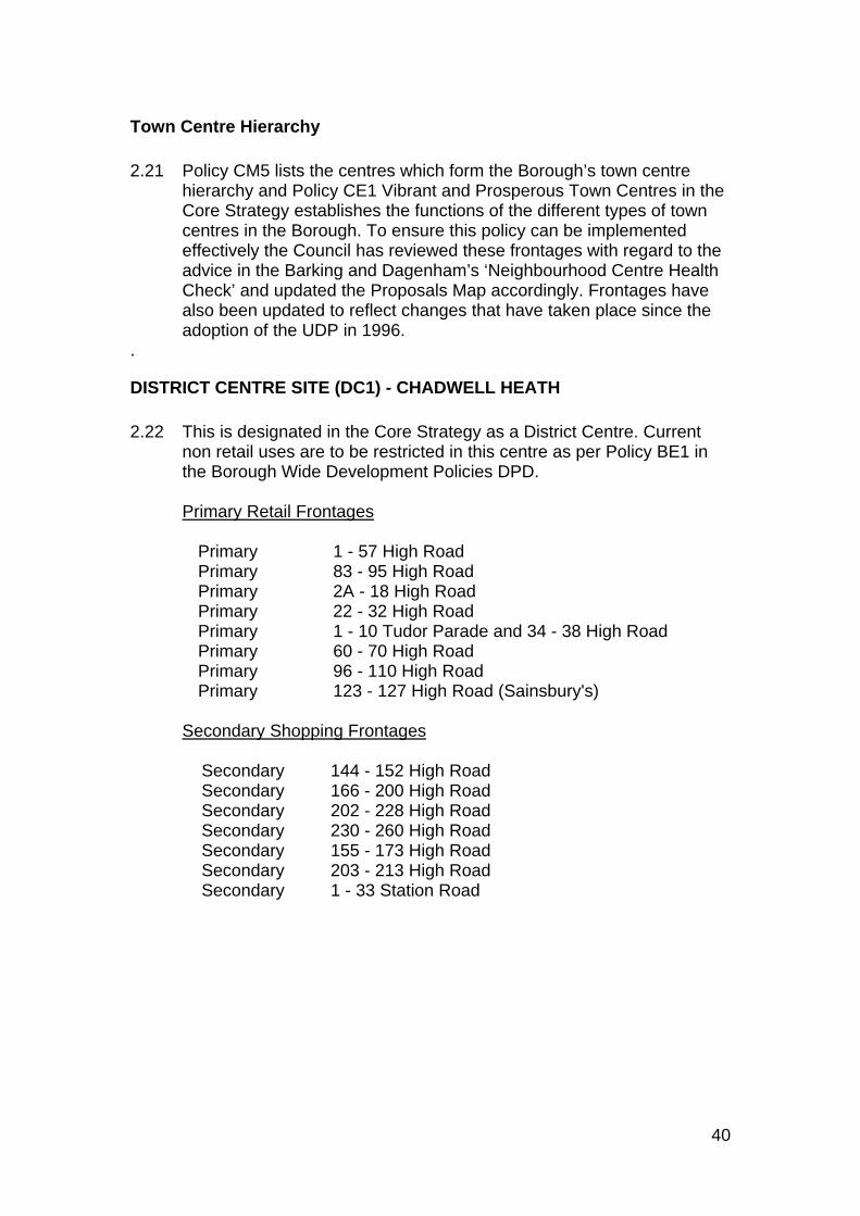
40
Town Centre Hierarchy 2.21 Policy CM5 lists the centres which form the Borough’s town centre
hierarchy and Policy CE1 Vibrant and Prosperous Town Centres in the Core Strategy establishes the functions of the different types of town centres in the Borough. To ensure this policy can be implemented effectively the Council has reviewed these frontages with regard to the advice in the Barking and Dagenham’s ‘Neighbourhood Centre Health Check’ and updated the Proposals Map accordingly. Frontages have also been updated to reflect changes that have taken place since the adoption of the UDP in 1996.
.
DISTRICT CENTRE SITE (DC1) - CHADWELL HEATH 2.22 This is designated in the Core Strategy as a District Centre. Current
non retail uses are to be restricted in this centre as per Policy BE1 in the Borough Wide Development Policies DPD.
Designation Primary Retail Frontages
Primary 1 - 57 High Road Primary 83 - 95 High Road Primary 2A - 18 High Road Primary 22 - 32 High Road Primary 1 - 10 Tudor Parade and 34 - 38 High Road Primary 60 - 70 High Road Primary 96 - 110 High Road Primary 123 - 127 High Road (Sainsbury's)
Secondary Shopping Frontages
Secondary 144 - 152 High Road Secondary 166 - 200 High Road Secondary 202 - 228 High Road Secondary 230 - 260 High Road Secondary 155 - 173 High Road Secondary 203 - 213 High Road Secondary 1 - 33 Station Road
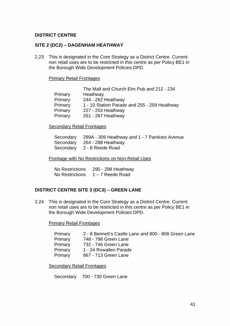
41
DISTRICT CENTRE
SITE 2 (DC2) – DAGENHAM HEATHWAY 2.23 This is designated in the Core Strategy as a District Centre. Current
non retail uses are to be restricted in this centre as per Policy BE1 in the Borough Wide Development Policies DPD.
Primary Retail Frontages
Primary The Mall and Church Elm Pub and 212 - 234 Heathway
Primary 244 - 262 Heathway Primary 1 - 10 Station Parade and 255 - 259 Heathway Primary 227 - 253 Heathway Primary 261 - 287 Heathway
Secondary Retail Frontages
Secondary 289A - 309 Heathway and 1 - 7 Parsloes Avenue Secondary 264 - 288 Heathway Secondary 2 - 8 Reede Road
Frontage with No Restrictions on Non-Retail Uses
No Restrictions 290 - 298 Heathway No Restrictions 1 – 7 Reede Road
DISTRICT CENTRE SITE 3 (DC3) – GREEN LANE 2.24 This is designated in the Core Strategy as a District Centre. Current
non retail uses are to be restricted in this centre as per Policy BE1 in the Borough Wide Development Policies DPD.
Primary Retail Frontages
Primary 2 - 8 Bennett’s Castle Lane and 800 - 808 Green Lane Primary 748 - 798 Green Lane Primary 732 - 746 Green Lane Primary 1 - 24 Rowallen Parade Primary 667 - 713 Green Lane
Secondary Retail Frontages
Secondary 700 - 730 Green Lane
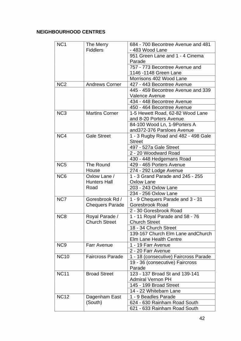
42
NEIGHBOURHOOD CENTRES
NC1 The Merry Fiddlers
684 - 700 Becontree Avenue and 481 - 483 Wood Lane 951 Green Lane and 1 - 4 Cinema Parade 757 - 773 Becontree Avenue and 1146 -1148 Green Lane Morrisons 402 Wood Lane
NC2 Andrews Corner 427 - 443 Becontree Avenue 445 - 459 Becontree Avenue and 339
Valence Avenue 434 - 448 Becontree Avenue 450 - 464 Becontree Avenue
NC3 Martins Corner 1-5 Hewett Road, 62-82 Wood Lane and 8-20 Porters Avenue 84-100 Wood Ln, 1-9Porters A and372-376 Parsloes Avenue
NC4 Gale Street 1 - 3 Rugby Road and 482 - 498 Gale Street 497 - 527a Gale Street 2 - 20 Woodward Road 430 - 448 Hedgemans Road
NC5 The Round House
429 - 465 Porters Avenue 274 - 292 Lodge Avenue
NC6 Oxlow Lane / Hunters Hall Road
1 - 3 Grand Parade and 245 - 255 Oxlow Lane 203 - 243 Oxlow Lane 234 - 256 Oxlow Lane
NC7 Goresbrook Rd / Chequers Parade
1 - 9 Chequers Parade and 3 - 31 Goresbrook Road 2 - 30 Goresbrook Road
NC8 Royal Parade / Church Street
1 - 11 Royal Parade and 58 - 76 Church Street 18 - 34 Church Street 139-167 Church Elm Lane andChurch Elm Lane Health Centre
NC9 Farr Avenue 1 - 19 Farr Avenue 2 - 20 Farr Avenue
NC10 Faircross Parade 1 - 18 (consecutive) Faircross Parade 19 - 36 (consecutive) Faircross Parade
NC11 Broad Street 123 - 137 Broad St and 139-141 Admiral Vernon PH 145 - 199 Broad Street 14 - 22 Whitebarn Lane
NC12 Dagenham East (South)
1 - 9 Beadles Parade 624 - 630 Rainham Road South 621 - 633 Rainham Road South
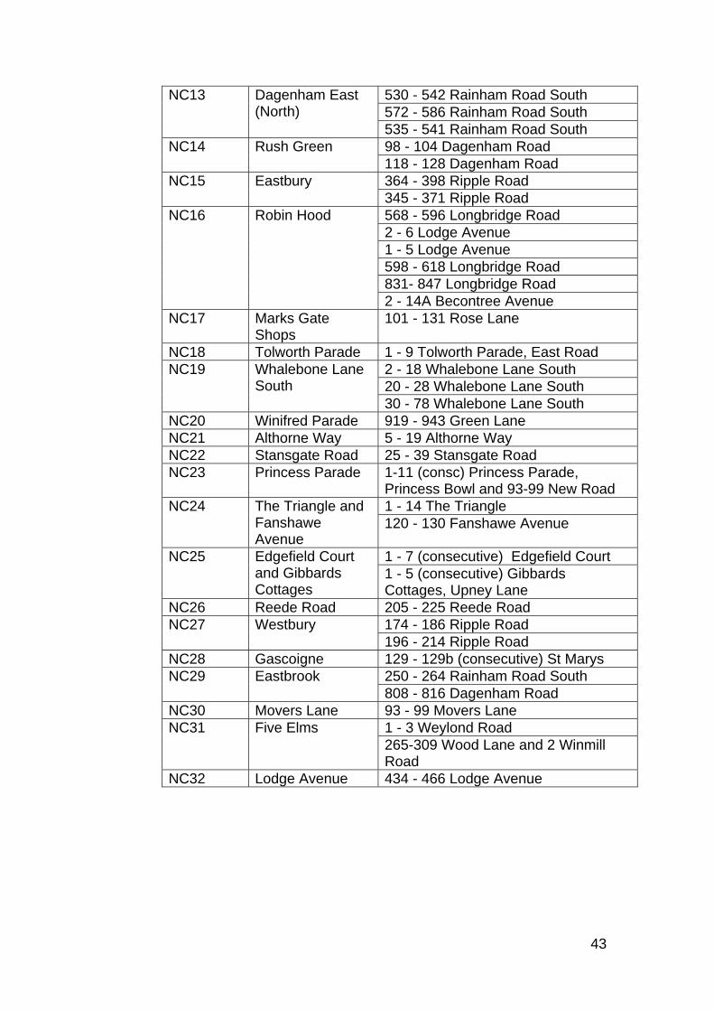
43
NC13 Dagenham East (North)
530 - 542 Rainham Road South 572 - 586 Rainham Road South 535 - 541 Rainham Road South
NC14 Rush Green 98 - 104 Dagenham Road 118 - 128 Dagenham Road
NC15 Eastbury 364 - 398 Ripple Road 345 - 371 Ripple Road
NC16 Robin Hood 568 - 596 Longbridge Road 2 - 6 Lodge Avenue 1 - 5 Lodge Avenue 598 - 618 Longbridge Road 831- 847 Longbridge Road 2 - 14A Becontree Avenue
NC17 Marks Gate Shops
101 - 131 Rose Lane
NC18 Tolworth Parade 1 - 9 Tolworth Parade, East Road NC19 Whalebone Lane
South 2 - 18 Whalebone Lane South 20 - 28 Whalebone Lane South 30 - 78 Whalebone Lane South
NC20 Winifred Parade 919 - 943 Green Lane NC21 Althorne Way 5 - 19 Althorne Way NC22 Stansgate Road 25 - 39 Stansgate Road NC23 Princess Parade 1-11 (consc) Princess Parade,
Princess Bowl and 93-99 New Road NC24 The Triangle and
Fanshawe Avenue
1 - 14 The Triangle 120 - 130 Fanshawe Avenue
NC25 Edgefield Court and Gibbards Cottages
1 - 7 (consecutive) Edgefield Court 1 - 5 (consecutive) Gibbards Cottages, Upney Lane
NC26 Reede Road 205 - 225 Reede Road NC27 Westbury 174 - 186 Ripple Road
196 - 214 Ripple Road NC28 Gascoigne 129 - 129b (consecutive) St Marys NC29 Eastbrook 250 - 264 Rainham Road South
808 - 816 Dagenham Road NC30 Movers Lane 93 - 99 Movers Lane NC31 Five Elms 1 - 3 Weylond Road
265-309 Wood Lane and 2 Winmill Road
NC32 Lodge Avenue 434 - 466 Lodge Avenue
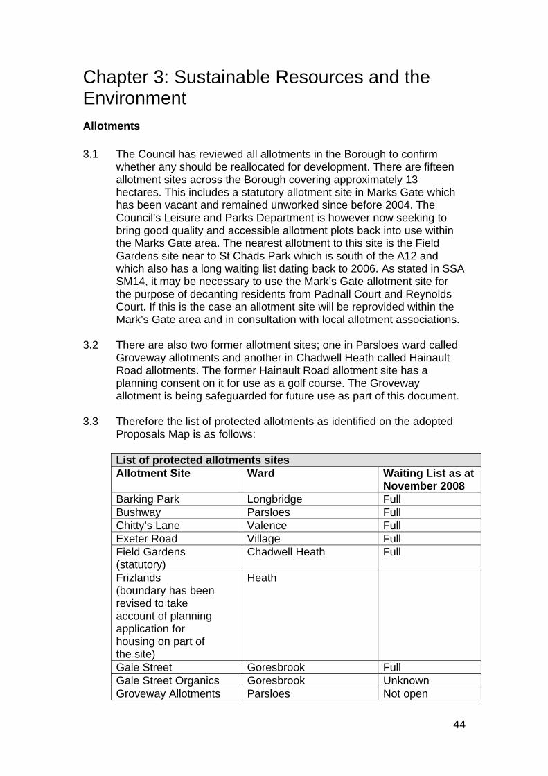
44
Chapter 3: Sustainable Resources and the Environment Allotments 3.1 The Council has reviewed all allotments in the Borough to confirm
whether any should be reallocated for development. There are fifteen allotment sites across the Borough covering approximately 13 hectares. This includes a statutory allotment site in Marks Gate which has been vacant and remained unworked since before 2004. The Council’s Leisure and Parks Department is however now seeking to bring good quality and accessible allotment plots back into use within the Marks Gate area. The nearest allotment to this site is the Field Gardens site near to St Chads Park which is south of the A12 and which also has a long waiting list dating back to 2006. As stated in SSA SM14, it may be necessary to use the Mark’s Gate allotment site for the purpose of decanting residents from Padnall Court and Reynolds Court. If this is the case an allotment site will be reprovided within the Mark’s Gate area and in consultation with local allotment associations.
3.2 There are also two former allotment sites; one in Parsloes ward called
Groveway allotments and another in Chadwell Heath called Hainault Road allotments. The former Hainault Road allotment site has a planning consent on it for use as a golf course. The Groveway allotment is being safeguarded for future use as part of this document.
3.3 Therefore the list of protected allotments as identified on the adopted
Proposals Map is as follows:
List of protected allotments sites Allotment Site Ward Waiting List as at
November 2008 Barking Park Longbridge Full Bushway Parsloes Full Chitty’s Lane Valence Full Exeter Road Village Full Field Gardens (statutory)
Chadwell Heath Full
Frizlands (boundary has been revised to take account of planning application for housing on part of the site)
Heath
Gale Street Goresbrook Full Gale Street Organics Goresbrook Unknown Groveway Allotments Parsloes Not open
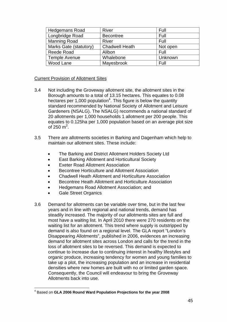
45
Hedgemans Road River Full Longbridge Road Becontree Full Manning Road River Full Marks Gate (statutory) Chadwell Heath Not open Reede Road Alibon Full Temple Avenue Whalebone Unknown Wood Lane Mayesbrook Full
Current Provision of Allotment Sites 3.4 Not including the Groveway allotment site, the allotment sites in the
Borough amounts to a total of 13.15 hectares. This equates to 0.08 hectares per 1,000 population4. This figure is below the quantity standard recommended by National Society of Allotment and Leisure Gardeners (NSALG). The NSALG) recommends a national standard of 20 allotments per 1,000 households 1 allotment per 200 people. This equates to 0.125ha per 1,000 population based on an average plot size of 250 m2.
3.5 There are allotments societies in Barking and Dagenham which help to
maintain our allotment sites. These include:
The Barking and District Allotment Holders Society Ltd East Barking Allotment and Horticultural Society Exeter Road Allotment Association Becontree Horticulture and Allotment Association Chadwell Heath Allotment and Horticulture Association Becontree Heath Allotment and Horticulture Association Hedgemans Road Allotment Association; and Gale Street Organics
3.6 Demand for allotments can be variable over time, but in the last few
years and in line with regional and national trends, demand has steadily increased. The majority of our allotments sites are full and most have a waiting list. In April 2010 there were 270 residents on the waiting list for an allotment. This trend where supply is outstripped by demand is also found on a regional level. The GLA report “London’s Disappearing Allotments”, published in 2006, evidences an increasing demand for allotment sites across London and calls for the trend in the loss of allotment sites to be reversed. This demand is expected to continue to increase due to continuing interest in healthy lifestyles and organic produce, increasing tendency for women and young families to take up a plot, the increasing population and an increase in residential densities where new homes are built with no or limited garden space. Consequently, the Council will endeavour to bring the Groveway Allotments back into use.
4 Based on GLA 2006 Round Ward Population Projections for the year 2008
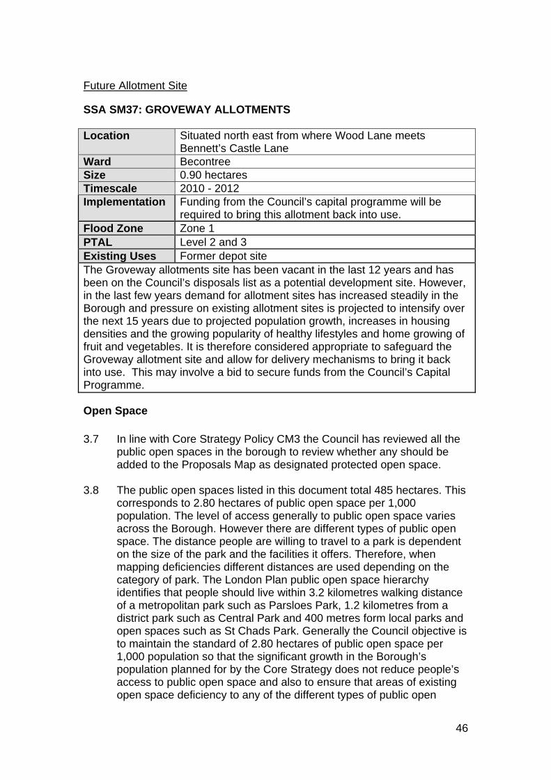
46
Future Allotment Site
SSA SM37: GROVEWAY ALLOTMENTS Location Situated north east from where Wood Lane meets
Bennett’s Castle Lane Ward Becontree Size 0.90 hectares Timescale 2010 - 2012 Implementation Funding from the Council’s capital programme will be
required to bring this allotment back into use. Flood Zone Zone 1 PTAL Level 2 and 3 Existing Uses Former depot site The Groveway allotments site has been vacant in the last 12 years and has been on the Council’s disposals list as a potential development site. However, in the last few years demand for allotment sites has increased steadily in the Borough and pressure on existing allotment sites is projected to intensify over the next 15 years due to projected population growth, increases in housing densities and the growing popularity of healthy lifestyles and home growing of fruit and vegetables. It is therefore considered appropriate to safeguard the Groveway allotment site and allow for delivery mechanisms to bring it back into use. This may involve a bid to secure funds from the Council’s Capital Programme.
Open Space 3.7 In line with Core Strategy Policy CM3 the Council has reviewed all the
public open spaces in the borough to review whether any should be added to the Proposals Map as designated protected open space.
3.8 The public open spaces listed in this document total 485 hectares. This
corresponds to 2.80 hectares of public open space per 1,000 population. The level of access generally to public open space varies across the Borough. However there are different types of public open space. The distance people are willing to travel to a park is dependent on the size of the park and the facilities it offers. Therefore, when mapping deficiencies different distances are used depending on the category of park. The London Plan public open space hierarchy identifies that people should live within 3.2 kilometres walking distance of a metropolitan park such as Parsloes Park, 1.2 kilometres from a district park such as Central Park and 400 metres form local parks and open spaces such as St Chads Park. Generally the Council objective is to maintain the standard of 2.80 hectares of public open space per 1,000 population so that the significant growth in the Borough’s population planned for by the Core Strategy does not reduce people’s access to public open space and also to ensure that areas of existing open space deficiency to any of the different types of public open
47
space are addressed. The Council will seek to achieve this in two ways as set out in Policy CM3 of the Core Strategy and the Borough Wide Development Policies:
By protecting the public open spaces listed in this document. The provision of new public open space primarily in connection with
strategic and major developments and through the implementation of the East London Green Grid Network.
More detail on public open space standards and deficiencies will be set out in the Community Benefits SPD.
3.9 The updated list of protected open spaces shown on the adopted
Proposals Map is as follows:
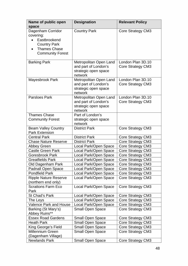
48
Name of public open space
Designation Relevant Policy
Dagenham Corridor covering: Eastbrookend
Country Park Thames Chase
Community Forest
Country Park Core Strategy CM3
Barking Park Metropolitan Open Land and part of London’s strategic open space network
London Plan 3D.10 Core Strategy CM3
Mayesbrook Park Metropolitan Open Land and part of London’s strategic open space network
London Plan 3D.10 Core Strategy CM3
Parsloes Park Metropolitan Open Land and part of London’s strategic open space network
London Plan 3D.10 Core Strategy CM3
Thames Chase Community Forest
Part of London’s strategic open space network
Beam Valley Country Park Extension
District Park Core Strategy CM3
Central Park District Park Core Strategy CM3 Chase Nature Reserve District Park Core Strategy CM3 Abbey Green Local Park/Open Space Core Strategy CM3 Castle Green Park Local Park/Open Space Core Strategy CM3 Goresbrook Park Local Park/Open Space Core Strategy CM3 Greatfields Park Local Park/Open Space Core Strategy CM3 Old Dagenham Park Local Park/Open Space Core Strategy CM3 Padnall Open Space Local Park/Open Space Core Strategy CM3 Pondfield Park Local Park/Open Space Core Strategy CM3 Ripple Nature Reserve (northern end only)
Local Park/Open Space Core Strategy CM3
Scrattons Farm Eco Park
Local Park/Open Space Core Strategy CM3
St Chad’s Park Local Park/Open Space Core Strategy CM3 The Leys Local Park/Open Space Core Strategy CM3 Valence Park and House Local Park/Open Space Core Strategy CM3 Barking (St Mary’s) Abbey Ruins**
Small Open Space Core Strategy CM3
Essex Road Gardens Small Open Space Core Strategy CM3 Heath Park Small Open Space Core Strategy CM3 King George’s Field Small Open Space Core Strategy CM3 Millennium Green (Dagenham Village)
Small Open Space Core Strategy CM3
Newlands Park Small Open Space Core Strategy CM3
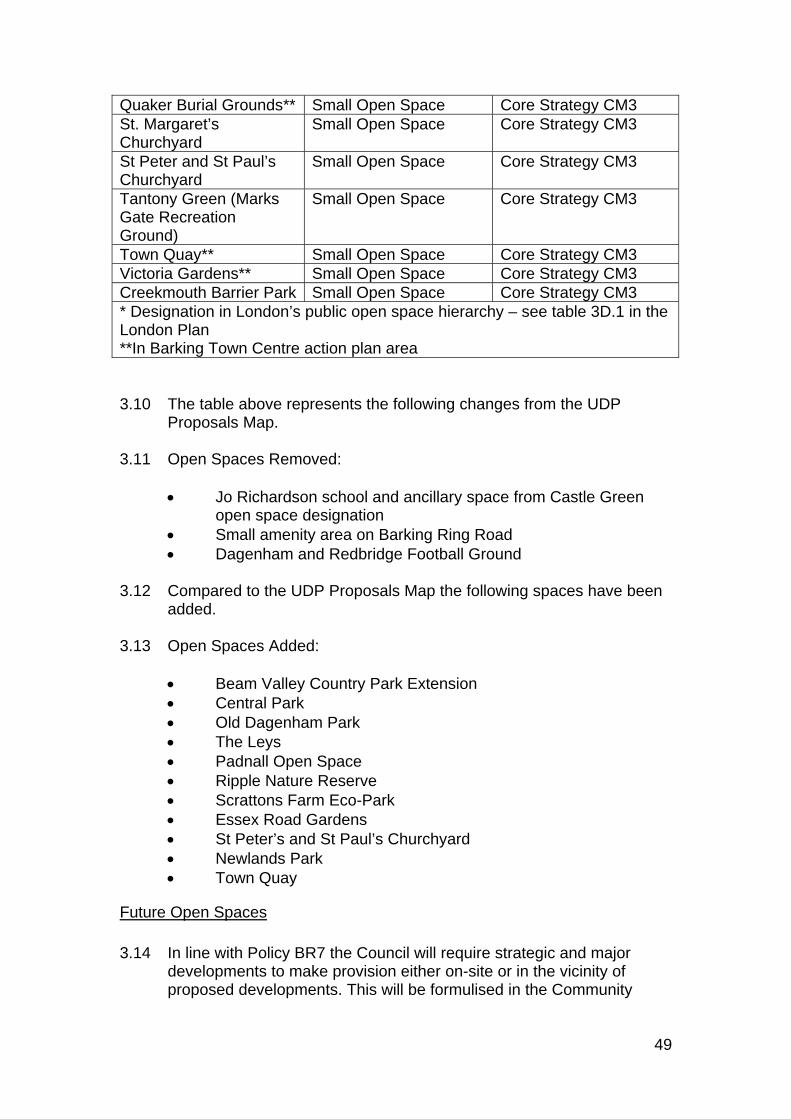
49
3.10 The table above represents the following changes from the UDP
Proposals Map. 3.11 Open Spaces Removed:
Jo Richardson school and ancillary space from Castle Green open space designation
Small amenity area on Barking Ring Road Dagenham and Redbridge Football Ground
3.12 Compared to the UDP Proposals Map the following spaces have been added. 3.13 Open Spaces Added:
Beam Valley Country Park Extension Central Park Old Dagenham Park The Leys Padnall Open Space Ripple Nature Reserve Scrattons Farm Eco-Park Essex Road Gardens St Peter’s and St Paul’s Churchyard Newlands Park Town Quay
Future Open Spaces
3.14 In line with Policy BR7 the Council will require strategic and major
developments to make provision either on-site or in the vicinity of proposed developments. This will be formulised in the Community
Quaker Burial Grounds** Small Open Space Core Strategy CM3 St. Margaret’s Churchyard
Small Open Space Core Strategy CM3
St Peter and St Paul’s Churchyard
Small Open Space Core Strategy CM3
Tantony Green (Marks Gate Recreation Ground)
Small Open Space Core Strategy CM3
Town Quay** Small Open Space Core Strategy CM3 Victoria Gardens** Small Open Space Core Strategy CM3 Creekmouth Barrier Park Small Open Space Core Strategy CM3 * Designation in London’s public open space hierarchy – see table 3D.1 in the London Plan **In Barking Town Centre action plan area
50
Benefits SPD. The Council is also implementing masterplans for a number of its principal parks.
3.15 Open spaces currently in the pipeline are set out below:
Barking Riverside – integration of a network of open spaces. University of East London – outline planning consent includes
provision of a series of publicly accessible open spaces. Lymington Fields – outline consent includes provision for publicly
accessible open space.
Sites of Importance for Nature Conservation 3.16 The borough’s Sites of Importance for Nature Conservation (SINCs)
were reviewed in 2002 as a result of a survey commissioned by the GLA. The Borough’s updated sites of importance for nature conservation are shown on the adopted Proposals Map as follows:
Site of Metropolitan Importance River Thames and Tidal Tributaries The Ripple Nature Reserve The Chase Nature Reserve and Eastbrookend Country Park Sites of Borough Importance, Grade I River Roding in Barking*5 Furze House Farm Dagenham Breach and the lower Beam River Beam Valley South and the Wantz Stream Mid-Beam Valley and Dagenham East Lake Goresbrook and the Ship and Shovel Mark’s Hedge and Hainault Road Allotments Sites of Borough Importance, Grade II Barking Park and Loxford Water Mayesbrook and associated watercourses Mayesbrook Park Lakes Parsloes Park White’s Farm Wantz lake and Crowlands Golf course Scratton’s Farm Ecopark Romford line railsides Sites of Local Importance Barking Abbey Ruins and St Margaret’s Churchyard* Gascoigne Road Pumping Station Rough St Chad’s Park Valence House Gardens Reed Road Allotments, Pondsfield Park and adjacent railsides
* In Barking Town Centre
51
St Peter’s and St Paul’s Churchyard, Dagenham Wellgate community farm
3.17 The table above represents the following changes from the Pre-Submission Proposals Map.
3.18 Nature Conservation Sites removed:
Thameside Park city community farm due to planning consent on the site for use as a sports amenity ground
Future Sites of Importance for Nature Conservation
3.19 Sites of importance for nature conservation will also be created as part
of successful management habitat plans implemented as part of major development schemes for example Barking Riverside.
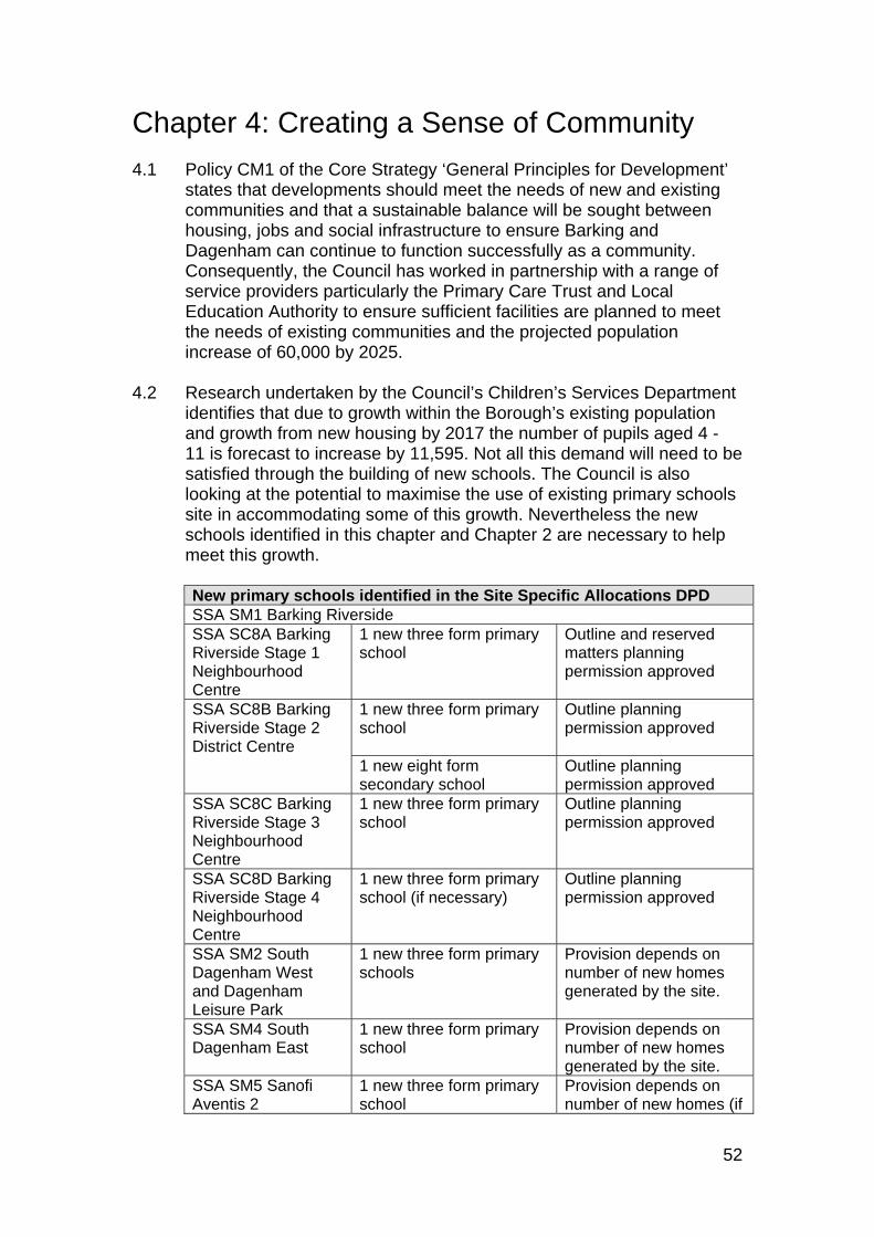
52
Chapter 4: Creating a Sense of Community 4.1 Policy CM1 of the Core Strategy ‘General Principles for Development’
states that developments should meet the needs of new and existing communities and that a sustainable balance will be sought between housing, jobs and social infrastructure to ensure Barking and Dagenham can continue to function successfully as a community. Consequently, the Council has worked in partnership with a range of service providers particularly the Primary Care Trust and Local Education Authority to ensure sufficient facilities are planned to meet the needs of existing communities and the projected population increase of 60,000 by 2025.
4.2 Research undertaken by the Council’s Children’s Services Department
identifies that due to growth within the Borough’s existing population and growth from new housing by 2017 the number of pupils aged 4 - 11 is forecast to increase by 11,595. Not all this demand will need to be satisfied through the building of new schools. The Council is also looking at the potential to maximise the use of existing primary schools site in accommodating some of this growth. Nevertheless the new schools identified in this chapter and Chapter 2 are necessary to help meet this growth.
New primary schools identified in the Site Specific Allocations DPD SSA SM1 Barking Riverside SSA SC8A Barking Riverside Stage 1 Neighbourhood Centre
1 new three form primary school
Outline and reserved matters planning permission approved
SSA SC8B Barking Riverside Stage 2 District Centre
1 new three form primary school
Outline planning permission approved
1 new eight form secondary school
Outline planning permission approved
SSA SC8C Barking Riverside Stage 3 Neighbourhood Centre
1 new three form primary school
Outline planning permission approved
SSA SC8D Barking Riverside Stage 4 Neighbourhood Centre
1 new three form primary school (if necessary)
Outline planning permission approved
SSA SM2 South Dagenham West and Dagenham Leisure Park
1 new three form primary schools
Provision depends on number of new homes generated by the site.
SSA SM4 South Dagenham East
1 new three form primary school
Provision depends on number of new homes generated by the site.
SSA SM5 Sanofi Aventis 2
1 new three form primary school
Provision depends on number of new homes (if
53
any) generated by the site.
SSA SM6 University of East London
1 new three form primary school
Detailed planning permission approved
SSA SM8 Lymington Fields
1 new three form primary school
Detailed planning permission approved
SSA SC3 Cannington Road
1 new three form primary school
Detailed planning permission approved
SSA SC4 St George’s Centre
1 new three form primary school
Included in the Council’s Capital Programme.
4.3 The Barking and Dagenham Joint Strategic Needs Assessment
identifies the main health and well being needs of the community and provides an understanding of the need for health and social care over the short and long term. It recognises that identifying the pre-requisite infrastructure to support growth is a key task of the Local Development Framework. The Transforming Community Services programme shifts the emphasis on providing more services in community based settings. Taking account of this and the emerging Health for North East London strategy NHS Barking and Dagenham has identified three polyclinic hubs at Barking Hospital, East Dagenham and Barking Riverside. These are dealt with in this document. SSA SM11 Hedgecock Centre and SSA SM12 Upney Lane Centre form part of the strategy for the improvements to health care on the Barking Hospital site. SSA SM5 identifies the Sanofi site as appropriate for a new polyclinic to serve East Dagenham. SSA SM1 Barking Riverside and the accompanying site specific allocations in this chapter SSA SC10 A-D cover the facilities necessary to meet the needs of the 10,800 new households planned on this strategic site. In particular SSA SC10B identifies provision for a new polyclinic within the Barking Riverside District Centre.
4.4 In addition NHS Barking and Dagenham has identified the need for
improved local health care facilities to meet existing and new demand. New facilities to meet existing demand and locally occurring growth has been identified at the SSA SM10 Becontree Heath, SSA SC7 Westbury Arms, SSA SC8 Julia Engwell Clinic, and SSA SC9 Brockelbank Lodge sites whilst facilities specifically to meet growth from new development have been identified on the SSA SM2 South Dagenham West and SSA SM4 South Dagenham East sites.
4.5 This chapter focuses on standalone infrastructure. Importantly, and in
keeping with Policy CC3 of the Core Strategy, social infrastructure will also be provided within the large housing sites set out in chapter 2.
4.6 The Council is also preparing a Community Benefits Supplementary
Planning Document. This will establish a standard charge which will represent the identified cost of providing the necessary environment, economic and social infrastructure to support new development and a range of schemes the proceeds will be spent on including those
54
identified in this document. Where a scheme provides supporting infrastructure the charge will be discounted proportionately.
Schools
SSA SC1: CANNINGTON ROAD Location Situated north west from Cannington Road Ward Mayesbrook Size 2.28 hectares Timescale 2010 - 2011 Implementation This former school site is owned by the Council and was
previously in educational use. Flood Zone Zone 1 PTAL 1 Existing Uses Former school site. This site is identified suitable for a new 3 form primary school.
SSA SC2: ST. GEORGE’S CENTRE Location Situated north from where St George’s Road meets
Halbutt Street Ward Parsloes Size 1.32 hectares Timescale 2010 - 2011 Implementation This former school site is owned by the Council and was
previously in educational use. Flood Zone Zone 1 PTAL Level 2 and 3 Existing Uses Council building and surgery This site is identified as suitable for a new 3 form primary school
Community Uses
SSA SC3: JAPAN ROAD COMMUNITY CENTRE Location Situated at the northern end of Japan Road Ward Chadwell Heath Size 0.10 hectares Timescale 2009 - 2011 Implementation The Council currently owns the site. It plans to dispose of
the site for a community use in line with this allocation. The building is in disrepair.
Flood Zone Zone 1 PTAL 3 Existing uses Former community centre.
55
There is an identified need for community space in this area which this is ideally placed to satisfy.
SSA SC4: WHALEBONE LANE SOUTH Location Situated between Purland Close and the southern
boundary of the Freshwater Water Road Employment AreaWard Whalebone Size 3.42 hectares Timescale Ongoing Implementation This site is in multiple private ownership Flood Zone Zone 1 PTAL 2 Existing uses Retail warehousing and vacant buildings. This site is suitable for the following uses:
Community uses in particular religious meeting places to meet the needs of the borough’s faith groups.
Out of centre retail proposals which meet the sequential test.
Planning Policy Statement 1 states that Plan policies should take into account the needs of all the community, including particular requirements relating to religion. Barking and Dagenham is now home to a very rich and diverse range of faith communities and the demand for religious meeting places to meet local needs in the borough is increasing. In response to this the Council published in 2008 a Planning Advice Note clarifying the preferred locations for religious meeting places. The note identifies locations within town centres or with good access to public transport as being particularly suitable. It also recognises that provided it can be demonstrated that they are no longer needed for retail warehousing purposes that vacant retail warehouses can be suitable for religious meeting places. The Council considers that this site is particularly well located to meet this local need as it is within walking distance of six different bus services which serve Barking, Dagenham and Chadwell Heath. Proposals for facilities which do not meet local needs will not be permitted on this site as it has been specifically identified because it is considered ideally located to respond to the pressing needs of local groups. Moreover in line with PPS1 the Council is focused on planning for sustainable communities and will not support a facility which draws the majority of its users from outside the Borough. In addition this site is an area which is increasingly becoming a zone of community and civic activity as it is nearby a number of other community and civic uses including the Civic Centre, and the proposed Becontree Leisure Centre as well as a number of schools. Applicants must follow the advice in
56
the Planning Advice Note regarding managing the impacts of religious meeting places in particular car parking and noise. The Core Strategy has de-designated the Whalebone Lane Retail Park as it seeks to direct retail uses to centres with the town centre hierarchy, however it recognises that where the sequential test is satisfied that out of centre stores are expected to be located within existing out of centre retail parks.
Healthcare
SSA SC5: WESTBURY ARMS Location Situated to the east of King Edwards Road where it meets
Ripple Road Ward Gascoigne Size 0.04 hectares Timescale 2010 - 2015 Implementation This is a privately owned site. It received permission in
July 2007 for conversion of ground floor into three Class A1 retail units and erection of roof extension in connection with conversion of upper levels into three two-bedroom flats. The Primary Care Trust have indicated that this would be a good opportunity for a primary care facility.
Flood Zone Zone 1 PTAL 4 Existing uses Derelict site This site has the potential for:
Health care Housing Retail
Development must address the following issues:
If possible retain the existing building which features on the Council’s local list of buildings of special local architectural or historic interest
Ensure any new building provides active frontages to Ripple Road and King Edward Road and emphasises the prominence of this corner in the streetscene.
SSA SC6: JULIA ENGWELL CLINIC
Location Situated to the west of Stamford Road north of Woodward Road
Ward Mayesbrook Size 0.64 hectares
57
Timescale 2009 – 2011. Implementation Part of the site is owned by the Primary Care Trust and
part of the site is owned by the Council. The Primary Care Trust is developing proposals to develop the site primarily for primary care and local health services with some residential element.
Flood Zone Zone 1 PTAL Level 2 Existing Uses Existing NHS clinic, formerly library and 2 community halls Proposed Uses and Design Requirements
This site has the potential for:
Health care Small scale residential use
Development must address the following issues: Have regard to the residential character of the area. A scheme must be
designed so as to avoid adverse impacts on residential amenity. This includes impacts arising from noise during, visual impact and traffic movements to and from the site during construction and occupation.
Need to maintain attractive frontage onto Stamford Road and Woodward Road.
SSA SC7: BROCKELBANK LODGE Location Situated to the north east of where Beacontree Avenue
meets Bennett’s Castle Lane Ward Valence Size 0.44 hectares Timescale 2009 – 2011 Implementation This site is currently owned by the Council. It is however
on the Land Disposals List and the PCT are developing proposals for the site.
Flood Zone Zone 1 PTAL Level 2 Existing Uses Former care home Proposed Uses and Design Requirements
This site has the potential for:
Health care Residential
Development must address the following issues:
Identified need by the PCT for GP services in this area
58
Have regard to the residential character of the area. A scheme must be designed so as to avoid adverse impacts on residential amenity. This includes impacts arising from noise during, visual impact and traffic movements to and from the site during construction and occupation.
SSA SC8: BARKING RIVERSIDE’S NEW NEIGHBOURHOOD AND DISTRICT CENTRES When outline planning permission for Barking Riverside was granted in 2006, and the Section 106 Agreement was signed in 2007, the developers Barking Riverside Ltd agreed to provide within the site three new Neighbourhood Centres and a new District Centre.
SSA SC8A: BARKING RIVERSIDE – STAGE 1 NEIGHBOURHOOD CENTRE Location Barking Riverside Stage 1 – South of Thames Road, West
of Renwick Road, East and North of River Road Size 20,400 m2 Timescale 2009 to 2012 Implementation Barking Riverside Ltd Flood Zone Flood risk Zone 1 but surrounded by flood risk Zone 3. PTAL Existing PTAL is 1. However, East London Transit phases
1a and 1b will serve Barking Riverside. A DLR extension to Dagenham Dock is also anticipated.
Indicative Capacity
Will contribute to site-wide capacity of 10,800 units.
Existing Uses Unoccupied brownfield land Proposed Uses and Design Requirements
Stage 1 of Barking Riverside is 45.2 hectares in size and will provide approximately 1,500 of the 10,800 new dwellings to be provided across the site. This stage will also be home to the first new Neighbourhood Centre, provisionally called the Rivergate Centre. The Rivergate Centre will provide a public square with the adjoining housing and community and retail facilities. The centre will face the park corridor to the north thus benefiting from the open green space. The primary school will be accessible from the public square and will be clustered with other community uses. Barking Riverside’s main cycle loop will pass through the centre, helping to animate the space. The ELT 1b service will pass the centre with a bus stop adjacent to the main public space. Motorised transport will be routed around rather than through the site, which itself will be dedicated to pedestrians. The Rivergate Centre will comprise the following uses:
59
Three form entry primary school with nursery. Place of worship (which will be shared by the Salvation Army, the
Methodist Church and the Church of England). Small police facility. Bookable community space (within the other uses e.g. the primary
school and the place of worship). Public toilets and baby changing facilities. Small convenience shop. Space suitable for the health authority to run services from. Office space for use by the Barking Riverside Community Development
Trust (BRCDT) as well as possibly by a housing officer or site manager and local employment and business coordinator.
In February 2010, a reserved matters planning application was granted to provide the detailed design of the Rivergate Neighbourhood Centre.
SSA SC8B: BARKING RIVERSIDE – STAGE 2 DISTRICT CENTRE Location Barking Riverside Stage 2 Size 51.6 hectares Timescale Phase 1 (Secondary school with extended community
facilities opens 2012) Phase 2 2017 Implementation Barking Riverside Ltd Flood Zone Flood risk Zone 1 but surrounded by flood risk Zone 3. PTAL Existing PTAL is 1. However, East London Transit phases
1a and 1b will serve Barking Riverside. A DLR extension to Dagenham Dock is also anticipated.
Indicative Capacity
Will contribute to site-wide capacity of 10,800 units.
Existing Uses Unoccupied brownfield land Proposed Uses and Design Requirements
Stage 2 of Barking Riverside is 51.6 hectares in size and will provide approximately 2,500 of the 10,800 new dwellings to be provided across the site. This stage will also be home to a new District Centre. The District Centre will hold a central position in Barking Riverside, on the eastern side of Renwick Road. It will be well connected by all modes of transport and will relate to both Barking Riverside Park and the Riverfront area. The centre will comprise a range of commercial and community activities. The District Centre will comprise the following uses:
60
Three form entry primary school with nursery. Children’s centre. Eight form entry secondary school (with extended community provision
including a library, community theatre space, and leisure facilities). Place of worship (a user for which will be identified through the Faith
Forum). Small police facility. Bookable community space (within the other uses). Public toilets and baby changing facilities. Retail store and other retail and commercial space. Polyclinic. Leisure centre including a swimming pool.
The District Centre will be built out in several phases as the local population grows. The first facility to be provided will be the secondary school, which will be built alongside the first 1,500 dwellings (which will be split between Stages 1 and 2 of the development). A brief setting out the location of the District Centre within Stage 2, and the agreed floorspace requirements for each of the above uses, was submitted to the LTGDC along with the Stage 1 Sub-Framework Plan and Reserved Matters planning applications which were submitted in January 2009.
SSA SC8C: BARKING RIVERSIDE – STAGE 3 NEIGHBOURHOOD CENTRE Location Barking Riverside Stage 3 Size TBC Timescale 2020 Implementation Barking Riverside Ltd Flood Zone Flood risk Zone 1 but surrounded by flood risk Zone 3. PTAL Existing PTAL is 1. However East London Transit phases
1a and 1b will serve Barking Riverside. A DLR extension to Dagenham Dock is also anticipated.
Indicative Capacity
Will contribute to site-wide capacity of 10,800 units
Existing Uses Unoccupied brownfield land Proposed Uses and Design Requirements
Stage 3 of Barking Riverside will provide approximately 3,300 of the 10,800 new dwellings to be provided across the site. This stage will also be home to a Neighbourhood Centre, provisionally called Eye Square. Eye Square will comprise the following uses:
Primary school with nursery (if required at that time by LBBD).
61
Children’s centre (if required at that time by LBBD). Place of worship (which will be shared by the Salvation Army, the
Methodist Church and the Church of England). Small police facility. Bookable community space (within the other uses e.g. the primary
school and the place of worship. Public toilets and baby changing facilities. Small convenience shop. Space suitable for the health authority to run services from Office space for use by the Barking Riverside Community Development
Trust (BRCDT) as well as possibly by a housing officer or site manager and local employment and business coordinator.
Eye Square will be a focal point for public attention at the highest point in Barking Riverside. It will be a lively urban public space at one of the key gateways into the side. There will be ELT and DLR stops and it will be passed by the main cycle loop. The ‘eye’ shape of the space will be formed from infrastructure curving around and will be emphasized by the existing topography. The space will be hard surfaced and have an urban feel. The area will also provide a hub for small businesses and live-work units. This will accentuate the area’s public character and its location in a transitional area between Barking Riverside and Dagenham Dock.
SSA SC8D: BARKING RIVERSIDE – STAGE 4 NEIGHBOURHOOD CENTRE Location Barking Riverside Stage 4 Size TBC Timescale 2025 Implementation Barking Riverside Ltd Flood Zone Flood risk Zone 1 but surrounded by flood risk Zone 3. PTAL Existing PTAL is 1. However East London Transit phases
1a and 1b will serve Barking Riverside. A DLR extension to Dagenham Dock is also anticipated.
Indicative Capacity
Will contribute to site-wide capacity of 10,800 units
Existing Uses Unoccupied brownfield land Proposed Uses and Design Requirements
Stage 4 of Barking Riverside will provide approximately 3,500 of the 10,800 new dwellings to be provided across the site. This stage will also be home to a Neighbourhood Centre, provisionally called Jetty Square / the Riverfront Centre. This centre will comprise the following uses:
62
Primary school with nursery (if required at that time by LBBD). Children’s centre (if required at that time by LBBD). Place of worship (which will be shared by the Salvation Army, the
Methodist Church and the Church of England). Small police facility. Bookable community space (within the other uses e.g. the primary
school and the place of worship). Public toilets and baby changing facilities. Small convenience shop. Space suitable for the health authority to run services from. Office space for use by the Barking Riverside Community Development
Trust (BRCDT) as well as possibly by a housing officer or site manager and local employment and business coordinator.
Any scheme which includes the jetty would require the formal consent of the PLA.
This centre will also be home to a range of food and drink uses, and to water based leisure clubs, designed to attract visitors from a wider catchment. The area will be an important public space providing an opportunity for people to walk from other parts of the development to the river frontage.
63
Chapter 5: Ensuring a Vibrant Economy and Attractive Town Centres 5.1 Policy CE3 of the Core Strategy identifies three Strategic Industrial
Locations:
River Road Employment Area Rippleside Dagenham Dock
5.2 And eight Locally Significant Industrial Sites:
Hertford Road Fresh Wharf (southern part) Gascoigne Business Area Dagenham Ford Sterling Industrial Estate/Wantz Road Freshwater Road Sanofi Aventis A13 South
5.3 It identifies the release of 59.5 hectares of designated employment
land, in line with the East London SRDF which recommends that 62-84 hectares of industrial land should be transferred to other uses between 2001 and 2016.
5.4 Through the Issues and Options process the Council has considered
the most appropriate uses for these sites and un-designated sites currently used for employment uses. The net impact of these changes in that the extent of the Locally Significant Industrial Sites has been reduced by 16.5 hectares through the de designation of Sanofi 2. The extent of the Strategic Industrial Locations has been increased by 2.37 hectares through the addition of the Costco site. The net loss of employment land therefore is 14.13 hectares. When added to the 59.5 hectares of employment land released by policy CE3 of the Core Strategy, this brings the total release to 74 hectares. This is within the range identified for release in the East London Sub Regional Development Framework and referred to in Policy CE3 of the Core Strategy
Strategic Industrial Locations
The Rippleside Strategic Industrial Location
5.5 The Rippleside Strategic Industrial Location has been extended to
include the former Gateway sites and Kuehne and Nagel site. Both
64
these sites are established employment areas, south of the A13. The desired land use and form of development for the Freight Interchange is covered in SM47. The Kuehne and Nagel site is considered particularly suited to logistics uses. In addition to these two additions a triangle of land where Ripple Road meets the A13 has also been added. All three of these ‘additions’ do not represent an increase in Strategic Industrial Locations because they were never formally released.
The River Road Strategic Industrial Location
5.6 The Kingsway Industrial Estate has been redesignated from a Locally
Significant Employment Site to a Strategic Industrial Location on the advice of the Greater London Authority. Again, as this was not formally released it does not represent an addition to Strategic Industrial Land. The Costco site to the east of Atcost Road has been added to the River Road Strategic Industrial Location.
Locally Significant Industrial Sites 5.7 The Lyon’s Business Centre has been designated as Locally
Significant Industrial Site. 5.8 This is a prominent gateway site to the Thames View Estate and
Barking Riverside. The Lyon’s Business Centre offers high quality modern business space. However the remaining area to the south of the site is of a poorer quality and appearance which is detrimental to the streetscene. This allocation aims to improve the appearance of this area so a higher quality of buildings can be provided. The site is designated as a Locally Significant Industrial Site. Policy CE3 enables the partial release of sites where it can be demonstrated the remaining part of the designated site will be more intensively developed to ensure no net loss in employment provided. This allocation therefore enables non-employment outside the Lyon’s Business Centre including housing under these terms.
SSA SE1: LYON’S BUSINESS PARK AND NEIGHBOURING EMPLOYMENT USES TO THE SOUTH Location Situated to the south east of where River Road meets the
A13 Ward Thames Size 3.17 hectares Timescale 2010 - 2015 Implementation This site is privately owned. Flood Zone Zone 3a PTAL Level 2 Existing Uses Lyon Business Park and neighbouring employment uses to
65
the south Proposed Uses and Design Requirements This site has the potential for: B1, B2 and B8 uses. Housing and other non-employment uses provided there is no net loss in
employment provided across the whole site, and no loss of employment land within the Lyon’s Road Business Centre.
Any new development must address the following issues:
Ensure flood risk is properly managed. The Sequential Test and parts a) and b) of the Exception Test have been undertaken for the site. It is necessary, however, for the applicant to undertake part c) of the Exception Test and prepare a flood risk assessment. Opportunities should be taken to locate more vulnerable uses to a zone of lower flood risk within the site boundary. If this is not possible, the development should be directed towards those areas of the site that have a lower degree of flood hazard and lengthy inundation rates (based upon the flood hazard and rate of inundation maps contained in the SFRA).
A need to provide a high quality frontage to River Road. Contributions will be sought towards improvements to the green amenity
area to the South East of the site. The site falls within an Archaeological Priority Area. The potential effect of
development on archaeological remains should be considered and mitigation measures implemented as appropriate.
The Sanofi Locally Significant Industrial Site
5.9 The Sanofi Locally Significant Industrial Site has been revised to
exclude Sanofi Site 2. There is little prospect of new employment uses being secured across the entire site. Its future use is covered in site number SM5 in chapter 2.
66
Chapter 6: Monitoring and Implementation Implementation 6.1 The Council is committed to working in partnership with a range of
stakeholders in the public, private, community and voluntary sectors in the delivery of the site specific allocations set out in this document.
6.2 The Local Housing Company which the Council has set up with its
private sector partner, First Base, will be particularly important and will have a major role to play in implementing a number of schemes including the Thames View regeneration site (SM13), the Marks Gate regeneration sites (SM14) and Goresbrook Village (SM15). These will be delivered by 2015. Masterplans for Thames View and Marks Gate are timetabled to be completed in 2009/10 and planning applications expected shortly afterwards. Plans for the Goresbrook Village (SM15) site are less advanced in line with its later timescale for implementation.
6.3 The Council is working in partnership with the Homes and
Communities Agency to deliver two sites. Outline permission has been granted for Lymington Fields (SM8) which will be built out by Countryside Properties. This will be complete by 2015. The Homes and Communities Agency has entered into a ltd company (Barking Riverside) with Bellway Homes to deliver Barking Riverside (SM1). This will take 25 years to build out due to the magnitude of the scheme. The Homes and Communities Agency are also providing assistance with the aforementioned Local Housing Company sites.
6.4 The London Plan identifies the London Riverside as an Opportunity
Area. As part of this, the Greater London Authority, including the London Development Agency will work in partnership with the Borough and other stakeholders to implement spatial planning framework(s) within the London Riverside area.
6.5 The London Development Agency and London Thames Gateway
Development Corporation own substantial parts of the South Dagenham West site, however the major landowner is Axa Sunlife who own the majority of the land to the west of Chequers Lane. The site allocation reflects the masterplanning which has already been undertaken for this site. This allocation also incorporates the Dagenham Leisure Park which is in private ownership. Again due to the magnitude of the scheme this site is expected to come forward between 2010 and 2020.
6.6 The North East London Health Trust own the Hedgecock Centre
(SM11) and Upney Lane Centre (SM12) sites. The Council has worked
67
in partnership with the Trust to decide the future of this sites which are surplus to requirements. These are scheduled to be complete by 2015.
6.7 The Council own the Barking Rugby Club and Goresbrook Leisure
Centre (SM3) site, and will work in partnership with existing uses to achieve this allocation. This is a mid to long term proposal, 2015-2020.
6.8 The Sanofi Aventis Site 2 (SM5) is privately owned, and the Council
will work in partnership with Sanofi Aventis to achieve this allocation from 2015-2020.
6.9 The University of East London (SM6) has an outline permission and
will be built out by Wimpey New Homes by 2015. 6.10 The Robin Hood Public House (SM7) has a full permission and is
expected to be built out by 2012. 6.11 The separate Housing and Implementation Strategy highlights the risks
involved in delivering these major sites. It details the criticality of those schemes omitted from the Transport for London Business Plan which will be reviewed through the Thames Gateway Strategic Review and the East London Sub-Regional Transport Strategy. Consequently the Council will continue to work closely with Transport for London and the Government to ensure that schemes such as the Docklands Light Railway Extension, Renwick Road Junction Improvements and East London Transit Phases 2 and 3 as shown in the London Plan are implemented. East London Transit Phases 1a and 1b are already committed and their routes safeguarded in SM36. Land is also safeguarded for the Renwick Road Junction improvements in SM34 due to its criticality in supporting growth south of the A13 and improving access across it.
6.12 Improved transport infrastructure is essential to deliver many of the
most significant sites identified in this document, but of equal importance are schools, health centres and open space. These are dealt with in chapters 3 and 4.
6.13 Allotments – demand for allotments is rising as they are a sustainable
and cheap food source. One new allotment has been identified and a bid to fund this will be made to its capital programme.
6.14 Open space – in comparison to the 1995 Unitary Development Plan a
number of new open spaces have been added. These are existing open spaces. Future open spaces will be delivered through major development for example open space will be provided as part of the University of East London, Lymington Fields and Barking Riverside schemes in line with policy BR7.
68
6.15 Sites of Importance for Nature Conservation – All the sites listed in the GLA Sites of Importance for Nature Conservation Study have been added.
6.16 Schools and children’s centres. As explained in Chapter 4 social
infrastructure will be provided within a number of the schemes in Chapter 2, and the Council has worked in partnership with the PCT and its Children’s Services department to ensure that the right number of facilities are secured and that they are in the right location. Chapter 4 deals with standalone facilities. Cannington Road and St George’s Centre are owned by the Council and are former school sites which will be returned to an education use by 2015. Department for Children, Schools and Families funding will be used to fund the Cannington Road and St George’s Centres schools. Funding may also be forthcoming from S106 contributions from nearby residential schemes. This will be formalised in the community benefits SPD. The Westbury Arms proposal is likely to be GP led although the Primary Care Trust has not excluded funding this themselves. However the PCT are leading the development of the Engwell Clinic and the Brocklebank Lodge schemes which will be completed by 2015.
6.17 The Council (for most planning applications) and the London Thames
Gateway Development Corporation (for the larger and more strategic applications in the Thames Gateway) will implement the various development control policies of the Plan. This will include securing Section 106 contributions from developers in order to implement key elements of the plan such as enhancements of the public realm, the provision of social infrastructure and transport improvements.
6.18 Apart from this Section 106 funding secured through developer
contributions, other important funding sources include Transport for London funding through the Local Implementation Plan (LIP) process, funding from the London Development Agency and the Homes and Communities Agency and the Council’s own capital funding.
Monitoring
6.19 The Council will monitor through its Annual Monitoring Report the
delivery of these sites against the timescales indicated for each allocation. Where delivery is not proceeding as anticipated the Council will in partnership with those involved identify the barriers to delivery and take the necessary actions to overcome these. Examples of actions are provided in the Housing Delivery and Implementation Strategy.
6.20 The Site Specific Allocations and policy designations included in this
document are necessary to deliver the Core Strategy and therefore will be very important in delivering the indicators and targets set out in the Core Strategy Monitoring and Implementation Framework. These indicators and targets will be reported annually in the Council’s Annual
69
Monitoring Report. In some cases the Site Specific Allocations may help achieve a number of targets in the Framework, particularly the larger developments such as Barking Riverside. However there follows an explanation of the main indicators and targets each allocation will help deliver and against which each allocation will be assessed:
The Significant Housing Sites (SSA SM1 – SSA SM15) are critical
to the achievement of a number of indicators most significantly the housing supply target of 1190 new homes per year set by Indicator CM2(b). The minor housing sites (SSA SM16 – SSA SM33) are also important in improving performance against this indicator.
The delivery of the Renwick Road Junction Improvements (SSA SM34) and the ELT1a and 1b routes (SSA SM36) will be monitored against indicator CM4 (a) which monitors the implementation of strategic transport schemes.
The delivery of the Strategic Rail Freight Terminal covered by SSA SM35 will be monitored against indicators CE3 (a), CE3 (c) and CE4 (c) which monitor the amount of additional floorspace provided, the availability of employment land and employment in each sector.
The town centre frontages will be monitored against indicators CE1 (b) to CE1 (e) which monitor the percentage of non retail uses in district centre and neighbourhood centre frontages.
The protected allotments listed in Chapter 3 will be monitored against indicator CM3 (d) which aims to ensure none of the protected allotments are lost to alternative uses, and the amount of public open space will be monitored against indicators CM3 (b) and (c) which again aim to ensure no net loss of public open space. The Sites of Importance for Nature Conservation will be monitored against indicator CR2 (a) which monitors the change in areas of biodiversity importance and aims for no net loss of existing SINCs.
Site allocations SSA SC3 to SSA SC10 A-D will be monitored against the indicators and related targets of CC 3 (a) (b) (c) (d) (e) and (f) which monitor the number of new community facilities provided, access to services and facilities by public transport, walking and cycling, average size of GP patient lists and available school places.
Strategic Industrial Locations and Locally Significant Industrial Sites will be monitored against indicators CE 3 (d) and (e) and the target set of no net loss of employment.
70
APPENDIX 1 Saved UDP policies to be superseded by the DPD On 27 September 2007, the Government Office for London extended the saved period for a number of Barking and Dagenham’s UDP policies. This table shows which of these saved UDP policies have been superseded by the Core Strategy, which are to be superseded by the Site Specific Allocations DPD (SSA DPD) and which will remain saved until they are replaced by other Development Plan Documents. Saved UDP Policy Status
STRATEGIC POLICY B HOUSING Superseded Core Strategy
STRATEGIC POLICY C HOUSING Superseded Core Strategy
STRATEGIC POLICY E EMPLOYMENT Superseded Core Strategy
STRATEGIC POLICY F EMPLOYMENT Superseded Core Strategy
STRATEGIC POLICY GSHOPPING Superseded Core Strategy
STRATEGIC POLICY H SHOPPING Superseded Core Strategy
STRATEGIC POLICY I ENVIRONMENT Superseded Core Strategy
STRATEGIC POLICY J ENVIRONMENT Superseded Core Strategy
STRATEGIC POLICY K ENVIRONMENT Superseded Core Strategy
STRATEGIC POLICY L ENVIRONMENT Superseded Core Strategy
STRATEGIC POLICY M ENVIRONMENT Superseded Core Strategy
STRATEGIC POLICY N ENVIRONMENT Superseded Core Strategy
STRATEGIC POLICY OENVIRONMENT Superseded Core Strategy
STRATEGIC POLICY X TRANSPORT Superseded Core Strategy
STRATEGIC POLICY Y TRANSPORT Superseded Core Strategy
STRATEGIC POLICY Z TRANSPORT Superseded Core Strategy
STRATEGIC POLICY AA TRANSPORT Superseded Core Strategy
STRATEGIC POLICY BB TRANSPORT Superseded Core Strategy
STRATEGIC POLICY CC TRANSPORT Superseded Core Strategy
POLICY H2 HOUSING Saved
POLICY H3 HOUSING Saved
POLICY H5 HOUSING Saved
POLICY H7 HOUSING Saved
POLICY H8 HOUSING Superseded Core Strategy
POLICY H9 HOUSING Saved
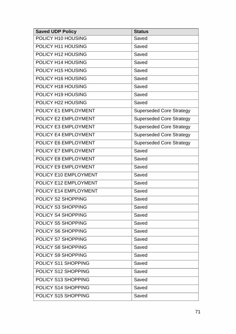
71
Saved UDP Policy Status
POLICY H10 HOUSING Saved
POLICY H11 HOUSING Saved
POLICY H12 HOUSING Saved
POLICY H14 HOUSING Saved
POLICY H15 HOUSING Saved
POLICY H16 HOUSING Saved
POLICY H18 HOUSING Saved
POLICY H19 HOUSING Saved
POLICY H22 HOUSING Saved
POLICY E1 EMPLOYMENT Superseded Core Strategy
POLICY E2 EMPLOYMENT Superseded Core Strategy
POLICY E3 EMPLOYMENT Superseded Core Strategy
POLICY E4 EMPLOYMENT Superseded Core Strategy
POLICY E6 EMPLOYMENT Superseded Core Strategy
POLICY E7 EMPLOYMENT Saved
POLICY E8 EMPLOYMENT Saved
POLICY E9 EMPLOYMENT Saved
POLICY E10 EMPLOYMENT Saved
POLICY E12 EMPLOYMENT Saved
POLICY E14 EMPLOYMENT Saved
POLICY S2 SHOPPING Saved
POLICY S3 SHOPPING Saved
POLICY S4 SHOPPING Saved
POLICY S5 SHOPPING Saved
POLICY S6 SHOPPING Saved
POLICY S7 SHOPPING Saved
POLICY S8 SHOPPING Saved
POLICY S9 SHOPPING Saved
POLICY S11 SHOPPING Saved
POLICY S12 SHOPPING Saved
POLICY S13 SHOPPING Saved
POLICY S14 SHOPPING Saved
POLICY S15 SHOPPING Saved

72
Saved UDP Policy Status
POLICY S16 SHOPPING Saved
POLICY S17 SHOPPING Saved
POLICY S19 SHOPPING Saved
POLICY B.T.C. 1 BARKING TOWN CENTRE
Saved
POLICY B.T.C. 2 BARKING TOWN CENTRE
Saved
POLICY B.T.C. 3 BARKING TOWN CENTRE
Saved
POLICY B.T.C. 4 BARKING TOWN CENTRE
Saved
POLICY B.T.C. 6 BARKING TOWN CENTRE
Saved
POLICY B.T.C. 8 BARKING TOWN CENTRE
Saved
POLICY B.T.C. 10 BARKING TOWN CENTRE
Saved
POLICY B.T.C. 12 BARKING TOWN CENTRE
Saved
POLICY B.T.C. 9 BARKING TOWN CENTRE
Saved
POLICY BR1 BARKING REACH Superseded SSA DPD
POLICY BR2 BARKING REACH Superseded SSA DPD
POLICY BR4 BARKING REACH Superseded SSA DPD
POLICY BR6 BARKING REACH Superseded SSA DPD
POLICY BR7 BARKING REACH Superseded SSA DPD
POLICY BR8 BARKING REACH Superseded SSA DPD
POLICY BR9 BARKING REACH Saved
POLICY BR10 BARKING REACH Superseded Core Strategy
POLICY BR11 BARKING REACH Superseded SSA DPD
POLICY BR12 BARKING REACH Saved
POLICY G1 ENVIRONMENT Superseded Core Strategy
POLICY G2 ENVIRONMENT Superseded Core Strategy
POLICY G3 ENVIRONMENT Superseded Core Strategy
POLICY G4 ENVIRONMENT Superseded Core Strategy
POLICY G5 ENVIRONMENT Superseded Core Strategy
POLICY G6 ENVIRONMENT Saved
POLICY G7 ENVIRONMENT Saved
POLICY G8 ENVIRONMENT Superseded Core Strategy
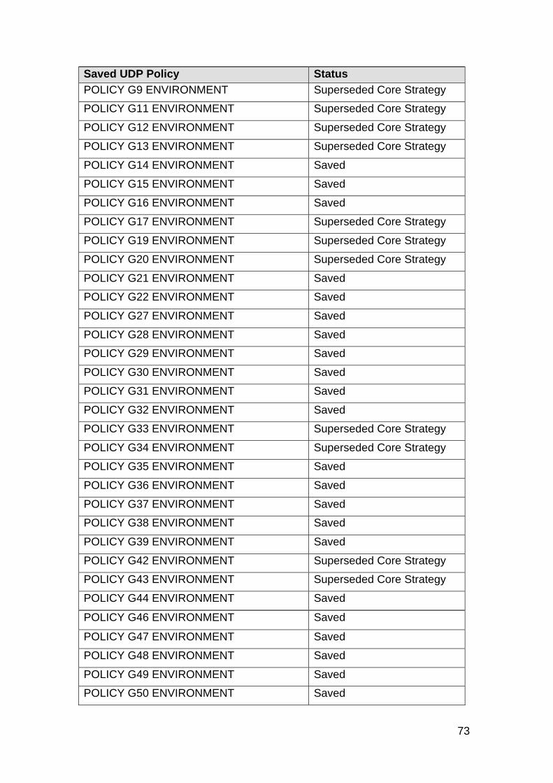
73
Saved UDP Policy Status
POLICY G9 ENVIRONMENT Superseded Core Strategy
POLICY G11 ENVIRONMENT Superseded Core Strategy
POLICY G12 ENVIRONMENT Superseded Core Strategy
POLICY G13 ENVIRONMENT Superseded Core Strategy
POLICY G14 ENVIRONMENT Saved
POLICY G15 ENVIRONMENT Saved
POLICY G16 ENVIRONMENT Saved
POLICY G17 ENVIRONMENT Superseded Core Strategy
POLICY G19 ENVIRONMENT Superseded Core Strategy
POLICY G20 ENVIRONMENT Superseded Core Strategy
POLICY G21 ENVIRONMENT Saved
POLICY G22 ENVIRONMENT Saved
POLICY G27 ENVIRONMENT Saved
POLICY G28 ENVIRONMENT Saved
POLICY G29 ENVIRONMENT Saved
POLICY G30 ENVIRONMENT Saved
POLICY G31 ENVIRONMENT Saved
POLICY G32 ENVIRONMENT Saved
POLICY G33 ENVIRONMENT Superseded Core Strategy
POLICY G34 ENVIRONMENT Superseded Core Strategy
POLICY G35 ENVIRONMENT Saved
POLICY G36 ENVIRONMENT Saved
POLICY G37 ENVIRONMENT Saved
POLICY G38 ENVIRONMENT Saved
POLICY G39 ENVIRONMENT Saved
POLICY G42 ENVIRONMENT Superseded Core Strategy
POLICY G43 ENVIRONMENT Superseded Core Strategy
POLICY G44 ENVIRONMENT Saved
POLICY G46 ENVIRONMENT Saved
POLICY G47 ENVIRONMENT Saved
POLICY G48 ENVIRONMENT Saved
POLICY G49 ENVIRONMENT Saved
POLICY G50 ENVIRONMENT Saved
74
Saved UDP Policy Status
POLICY G51 ENVIRONMENT Saved
POLICY G53 ENVIRONMENT Saved
POLICY G54 ENVIRONMENT Saved
POLICY G56 ENVIRONMENT Superseded SSA DPD
P0LICY G57 ENVIRONMENT Superseded Core Strategy
POLICY G58 ENVIRONMENT Superseded Core Strategy
POLICY G59 ENVIRONMENT Superseded Core Strategy
POLICY G60 ENVIRONMENT Superseded Core Strategy
POLICY G61 ENVIRONMENT Superseded Core Strategy
POLICY G62 ENVIRONMENT Saved
POLICY G63 ENVIRONMENT Saved
POLICY G64 ENVIRONMENT Superseded Core Strategy
POLICY G65 ENVIRONMENT Saved
POLICY G67 ENVIRONMENT Saved
POLICY G68 ENVIRONMENT Saved
POLICY G70 ENVIRONMENT Saved
POLICY G71 ENVIRONMENT Saved
POLICY G73 ENVIRONMENT Saved
POLICY G74 ENVIRONMENT Saved
POLICY G75 ENVIRONMENT Saved
POLICY G76 ENVIRONMENT Saved
POLICY G77 ENVIRONMENT Saved
POLICY DE1 DESIGN Superseded Core Strategy
POLICY DE2 DESIGN Saved
POLICY DE3 DESIGN Saved
POLICY DE6 DESIGN Saved
POLICY DE7 DESIGN Saved
POLICY DE8 DESIGN Superseded Core Strategy
POLICY DE9 DESIGN Superseded Core Strategy
POLICY DE11 DESIGN Saved
POLICY DE12 DESIGN Saved
POLICY DE13 DESIGN Saved
POLICY DE14 DESIGN Saved
75
Saved UDP Policy Status
POLICY DE15 DESIGN Saved
POLICY DE16 DESIGN Saved
POLICY DE17 DESIGN Saved
POLICY DE19 DESIGN Saved
POLICY DE20 DESIGN Saved
POLICY DE22 DESIGN Saved
POLICY DE23 DESIGN Saved
POLICY DE24 DESIGN Saved
POLICY DE25 DESIGN Saved
POLICY DE26 DESIGN Saved
POLICY DE27 DESIGN Saved
POLICY DE28 DESIGN Saved
POLICY DE30 DESIGN Saved
POLICY DE31 DESIGN Saved
POLICY DE32 DESIGN Saved
POLICY DE33 DESIGN Saved
POLICY DE35 DESIGN Saved
POLICY DE36 DESIGN Saved
POLICY DE37 DESIGN Saved
POLICY DE40 DESIGN Saved
POLICY DE42 DESIGN Saved
POLICY DE44 DESIGN Saved
POLICY DE45 DESIGN Saved
POLICY C2 COMMUNTY FACILITIES Superseded Core Strategy
POLICY C3 COMMUNTY FACILITIES Superseded Core Strategy
POLICY C4 COMMUNTY FACILITIES Superseded Core Strategy
POLICY C5 COMMUNTY FACILITIES Superseded Core Strategy
POLICY C6 COMMUNTY FACILITIES Superseded SSA DPD
POLICY C9 COMMUNTY FACILITIES Superseded Core Strategy
POLICY C11 COMMUNTY FACILITIES Superseded Core Strategy
POLICY C13 COMMUNTY FACILITIES Superseded Core Strategy
POLICY C14 COMMUNTY FACILITIES Saved
POLICY C15 COMMUNTY FACILITIES Superseded Core Strategy

76
Saved UDP Policy Status
POLICY C16 COMMUNTY FACILITIES Saved
POLICY C17 COMMUNTY FACILITIES Superseded Core Strategy
POLICY A.T.3 ARTS AND TOURISM Superseded Core Strategy
POLICY A.T.6 ARTS AND TOURISM Saved
POLICY A.T.8 ARTS AND TOURISM Saved
POLICY T 3 TRANSPORT Saved
POLICY T 5 TRANSPORT Superseded Core Strategy
POLICY T 7 TRANSPORT Saved
POLICY T 8 TRANSPORT Saved
POLICY T 9 TRANSPORT Saved
POLICY T 10 TRANSPORT Saved
POLICY T 12 TRANSPORT Saved
POLICY T 16 TRANSPORT Saved
POLICY T 17 TRANSPORT Saved
POLICY T 19 TRANSPORT Saved
POLICY T 20 TRANSPORT Saved
POLICY T 21 TRANSPORT Saved
POLICY T 23 TRANSPORT Superseded SSA DPD
POLICY T 24 TRANSPORT Saved
POLICY T 25 TRANSPORT Saved
POLICY T 26 TRANSPORT Saved
POLICY T 27 TRANSPORT Saved
POLICY T 30 TRANSPORT Saved
POLICY T 31 TRANSPORT Saved
POLICY T 32 TRANSPORT Saved
POLICY T 33 TRANSPORT Superseded Core Strategy
POLICY T 34 TRANSPORT Superseded Core Strategy
POLICY T 36 TRANSPORT Saved
77
APPENDIX 2
Managing Growth
Key Regeneration Areas and Significant Housing Sites SSA SM1: Barking Riverside
N
0 320 640160 Meters1:12,158
Barking Riverside
© Crown copyright. All rights reservedLicence number – 100019280 (2008)
78
SSA SM2: South Dagenham West and Dagenham Leisure Park
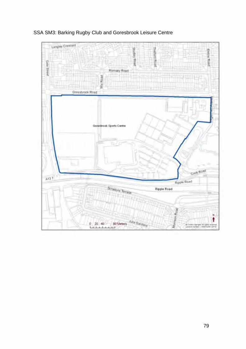
79
SSA SM3: Barking Rugby Club and Goresbrook Leisure Centre
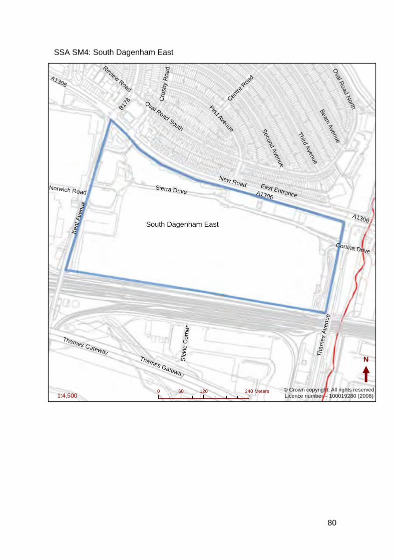
80
SSA SM4: South Dagenham East
A1306
New RoadSierra Drive
Ken
t Ave
nue
Oval Road South
Thames Gateway
Third Avenue
Second A
venue
First Avenue
Tha
me
s A
ven
ue
Beam
Avenue
East Entrance
Centre
Roa
d
Oval R
oad North
B178
Sic
kle
Cor
ner
Cro
sby
Roa
dReview Road
Norwich Road
Cortina Drive
A1306
Thames Gateway
A1306
N
0 120 24060 Meters1:4,500
© Crown copyright. All rights reservedLicence number – 100019280 (2008)
South Dagenham East
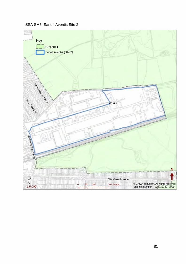
81
SSA SM5: Sanofi Aventis Site 2
Western Avenue
Gay G
ardensW
instead Gardens
Rainh
am R
oa
d Sou
th
A11
12
Works
N
0 100 20050 Meters1:5,000
Key
!
! ! !
!!
GreenBelt
Sanofi Aventis (Site 2)
© Crown copyright. All rights reservedLicence number – 100019280 (2009)
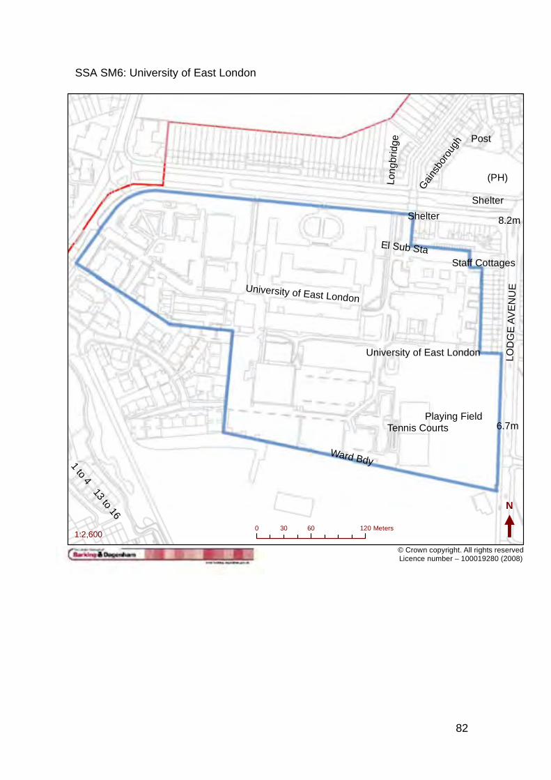
82
SSA SM6: University of East London
© Crown copyright. All rights reservedLicence number – 100019280 (2008)
University of East London
Playing Field
Lon
gbrid
ge
Ward Bdy
Gai
nsbo
roug
h
Tennis Courts
1 to 4
(PH)
Staff Cottages
El Sub Sta
LOD
GE
AV
EN
UE
Post
13 to 16
Shelter
6.7m
8.2m
University of East London
Shelter
N
0 60 12030 Meters1:2,600
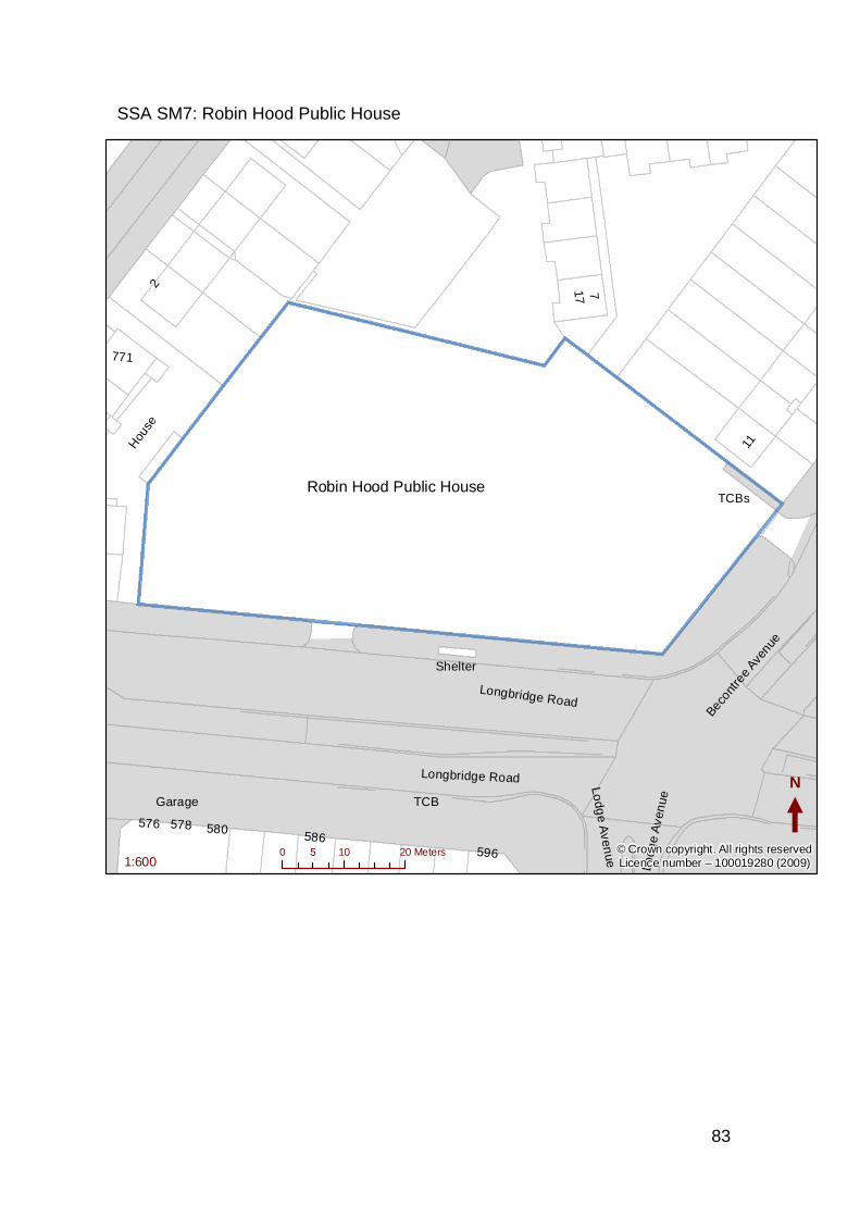
83
SSA SM7: Robin Hood Public House
Longbridge RoadBec
ontre
e Ave
nue
Lodg
e A
ven
ue
Longbridge Road Lodg
e Aven
ue
Hou
se
11
Garage
17
771
2
586596
576 578 580
7
Shelter
TCBs
TCB
N
0 10 205 Meters1:600
© Crown copyright. All rights reservedLicence number – 100019280 (2009)
Robin Hood Public House
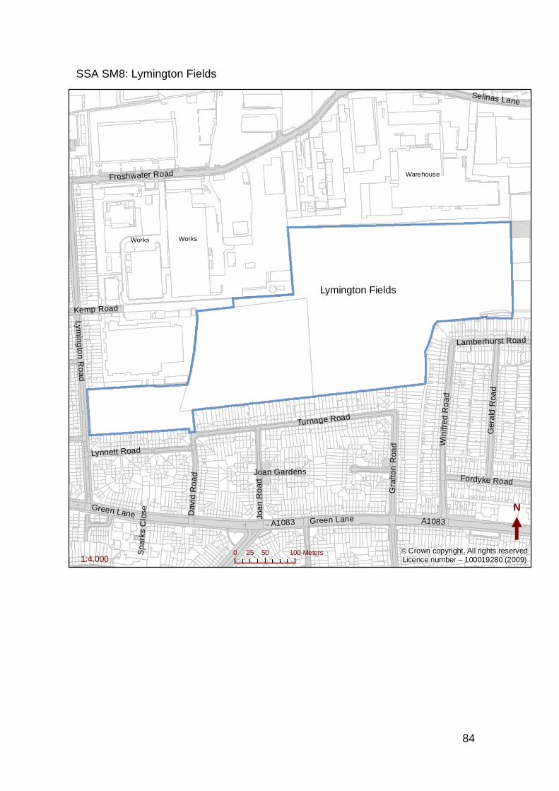
84
SSA SM8: Lymington Fields
A1083
Lyming
ton
Ro
ad
Freshwater Road
Turnage Road
Win
ifred
Ro
ad
Gra
fton
Roa
d
Ger
ald
Roa
d
Joa
n R
oad
Lynnett Road
Dav
id R
oa
d
Green Lane
Selinas Lane
Fordyke Road
Kemp Road
Lamberhurst Road
Joan Gardens
Sp
arks
Clo
se
A1083
Green Lane
Works
Warehouse
Works
N
0 50 10025 Meters1:4,000
© Crown copyright. All rights reservedLicence number – 100019280 (2009)
Lymington Fields
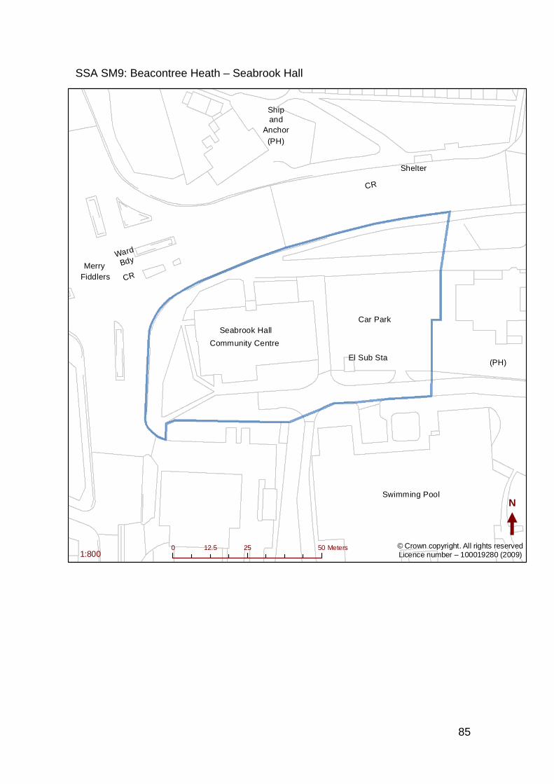
85
SSA SM9: Beacontree Heath – Seabrook Hall
Swimming Pool
Community Centre
Seabrook Hall
Ship
Anchor
FiddlersMerry
and
Car Park
Ward
Bdy
Shelter
El Sub Sta
(PH)
CR
(PH)
CR
N
0 25 5012.5 Meters1:800
© Crown copyright. All rights reservedLicence number – 100019280 (2009)
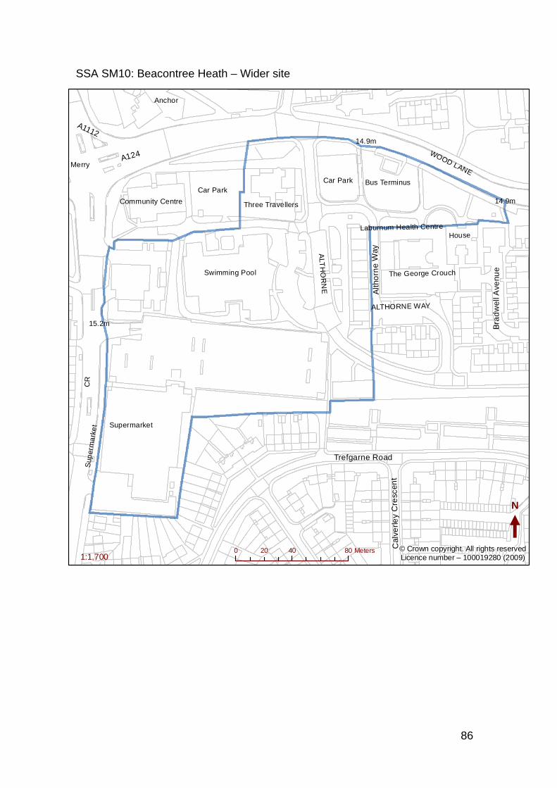
86
SSA SM10: Beacontree Heath – Wider site
A124
Trefgarne Road
Alth
orn
e W
ay
A1112
Cal
verle
y C
resc
ent
Bra
dw
ell A
venu
eSwimming Pool
WOOD LANE
Community Centre
Anchor
Merry
HouseLaburnum Health Centre
The George Crouch
Three Travellers
Bus Terminus
14.9m
15.2m
CR
Sup
erm
ark
et
Car Park
ALT
HO
RN
E
ALTHORNE WAY
14.9m
Supermarket
Car Park
N
0 40 8020 Meters1:1,700
© Crown copyright. All rights reservedLicence number – 100019280 (2009)
87
SSA SM11: Hedgecock Centre
Upney Station
Manor C
ourtGibbards
Edgefield PO
11
8
2
3
69
1
1315
1 to 1941
to 4
6
42
33 to 40
17
48
4 10
50
7
5
40
20
56
SL
LB
10.7m
El Sub S
ta
6.1m
8.2m
TCPs
12
2
3
1
SL
N
0 25 5012.5 Meters1:1,000
© Crown copyright. All rights reservedLicence number – 100019280 (2009)
Hedgecock Centre
88
SSA SM12: Upney Lane Centre
CH
AMPN
ESS RO
AD
Surgery
2
2 to 12
26 to 3638 to 48
14 to 24
123
232132
18
291
228
13
224
231
130
1
Shelter
El Sub S
ta
Clinic
2
N
0 10 205 Meters1:700
© Crown copyright. All rights reservedLicence number – 100019280 (2009)
Champness Road
89
SSA SM13: Thames View Regeneration Sites
Thames Road
Ren
wic
k R
oad
Alfreds Way
Bastable Avenue
Sisley Road
Blake
Ave
nue
River R
oad
Wivenhoe Road
Cre
ek R
oad
Ripple R
oad
A13 T
East Ham & Barking By Pass
Roxwell Road
Curzon Crescent
Galleons Drive
Alderman Avenue
Long Reach Road
Charlton Crescent
Stanley Avenue
Roycraft Avenue
Denham Way
Marine D
rive
Lodg
e Av
enue
Ab
ridg
e Way
Maybury Road
Rip
ple
Lan
e
Castle Road
Animal Way
A123
Sutton Road
Map
lest
ead
Roa
dC
helm
er C
resc
ent
Gle
nmor
e W
ay
Sugden Way
Gal
lions
Clo
se
Fa
rr A
venu
e
Ripple Road
N
0 250 500125 Meters1:8,000
© Crown copyright. All rights reservedLicence number – 100019280 (2009)
90
SSA SM14: Mark’s Gate Regeneration Sites
Rose
Lane
Pa
dna
ll Roa
d
Billet Road
Arneways Avenue
Long
haye
s Aven
ue
New
hou
se A
venu
e
Roles G
rove
Cra
btre
e Aven
ue
Uplan
ds Roa
d
Sheepcotes Road
Rosehatch Avenue
Tanton
y Gro
ve
Gre
gory
Roa
d
Nash Road
Bardfield Avenue
Gibbfield Close
Lake
Roa
d
Kingston C
lose
Rose
Lane
Rea
r Se
rvice R
oad
Lawn Farm Grove
Cavalier Close
Bille
t Close
LodgeN
0 50 10025 Meters1:3,300
Land at St Marks Church
Rose LaneGarages
Roles GroveGarages
Padnall Hall
Rose LaneWC Site
PadnallCourt
© Crown copyright. All rights reservedLicence number – 100019280 (2009)
ReynoldsCourt
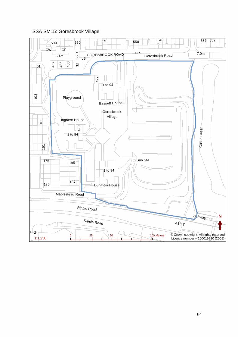
91
SSA SM15: Goresbrook Village
A13 TRipple Road
Goresbrook Road
Maplestead Road
Ripple Road
Goresbrook
Village
Bassett House
Ingrave House
Cas
tle G
reen
Dunmow House
7.0m6.4m GORESBROOK ROAD
Subway
1 to 94
175
429
580
187
151
103
61
558590570
185
1
433
435
105
437
548 532
2
536
195
427
Playground
LB
El Sub StaU
nd
CW CF
EK
CR
1 to 94
1 to 94
N
0 50 10025 Meters1:1,250
© Crown copyright. All rights reservedLicence number – 100019280 (2009)
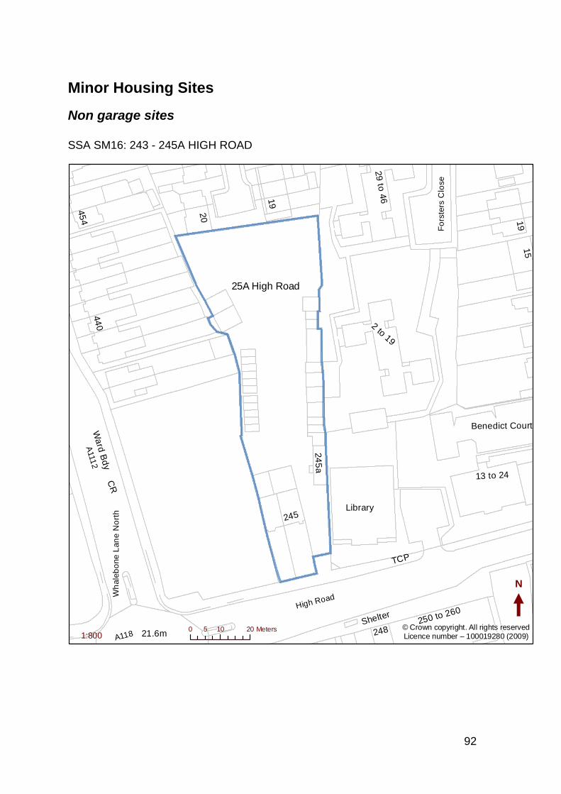
92
Minor Housing Sites
Non garage sites SSA SM16: 243 - 245A HIGH ROAD
A111
2
A118
High Road
Fo
rste
rs C
l ose
Wh
aleb
one
Lan
e N
ort
h
21.6m
Library
Wa
rd Bd
y
2 to 19
440
29 to 46
20
13 to 24
15
454
250 to 260
248
245
19
245
a
Shelter
Benedict Court
CR
TCP
19
N
0 10 205 Meters1:800
© Crown copyright. All rights reservedLicence number – 100019280 (2009)
25A High Road

93
SSA SM17: ROGER’S ROAD DEPOT, 81-83 ROGER’S ROAD
Corporation
Yard
RO
GE
RS
RO
AD
81
83
79
85
71 N
0 9 184.5 Meters1:400
© Crown copyright. All rights reservedLicence number – 100019280 (2009)
Roger Road Depot
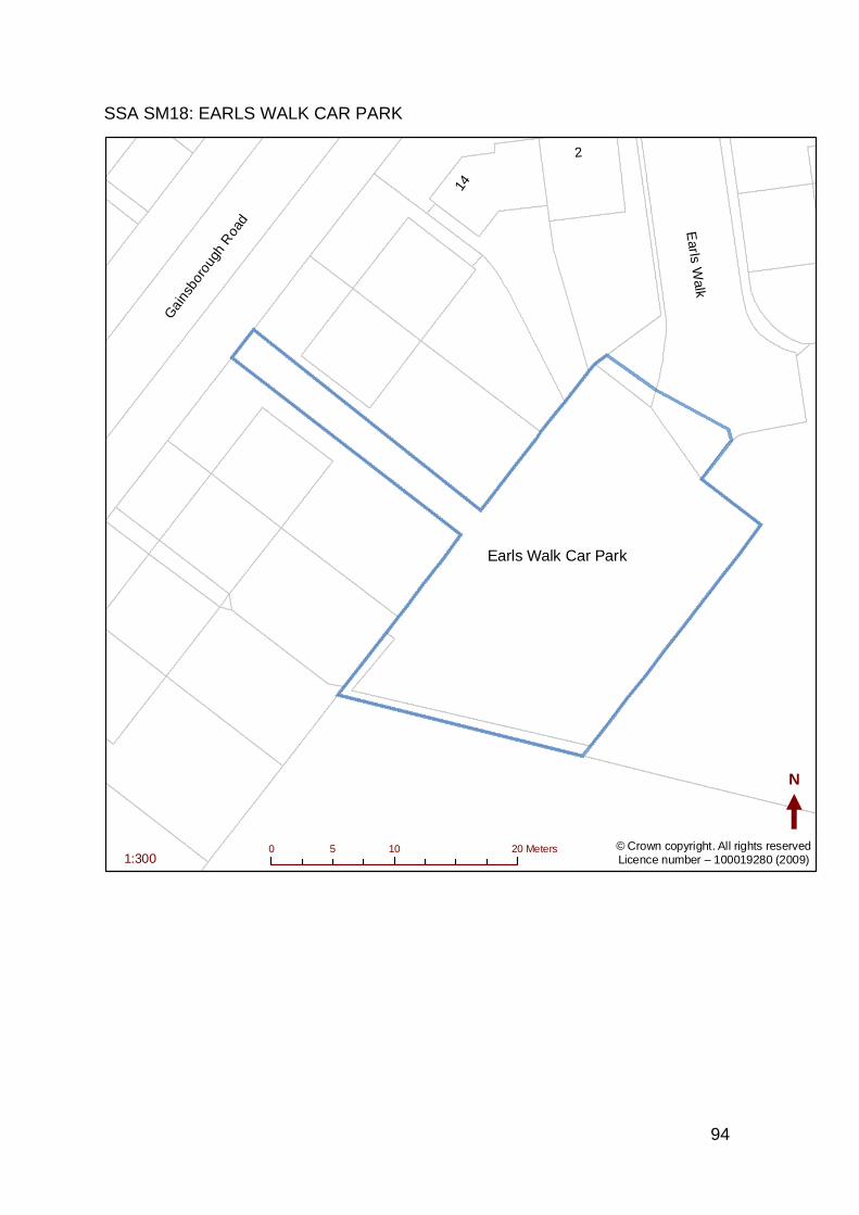
94
SSA SM18: EARLS WALK CAR PARK
Earls W
alkG
ains
boro
ugh
Roa
d
14
2
N
0 10 205 Meters1:300
© Crown copyright. All rights reservedLicence number – 100019280 (2009)
Earls Walk Car Park
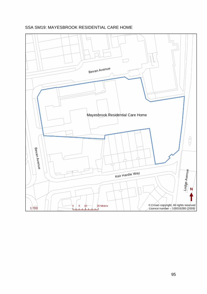
95
SSA SM19: MAYESBROOK RESIDENTIAL CARE HOME
Lod
ge A
ven
ue
Keir Hardie Way
Bevan Avenue
Beva
n Aven
ue
N
0 10 205 Meters1:700
© Crown copyright. All rights reservedLicence number – 100019280 (2009)
Mayesbrook Residential Care Home
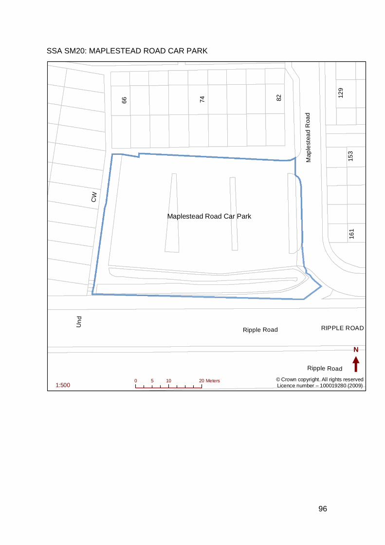
96
SSA SM20: MAPLESTEAD ROAD CAR PARK
Ripple Road
Map
lest
ead
Roa
d
Ripple Road RIPPLE ROAD
153
8274
129
66
161
Un
d
CW
N
0 10 205 Meters1:500
© Crown copyright. All rights reservedLicence number – 100019280 (2009)
Maplestead Road Car Park
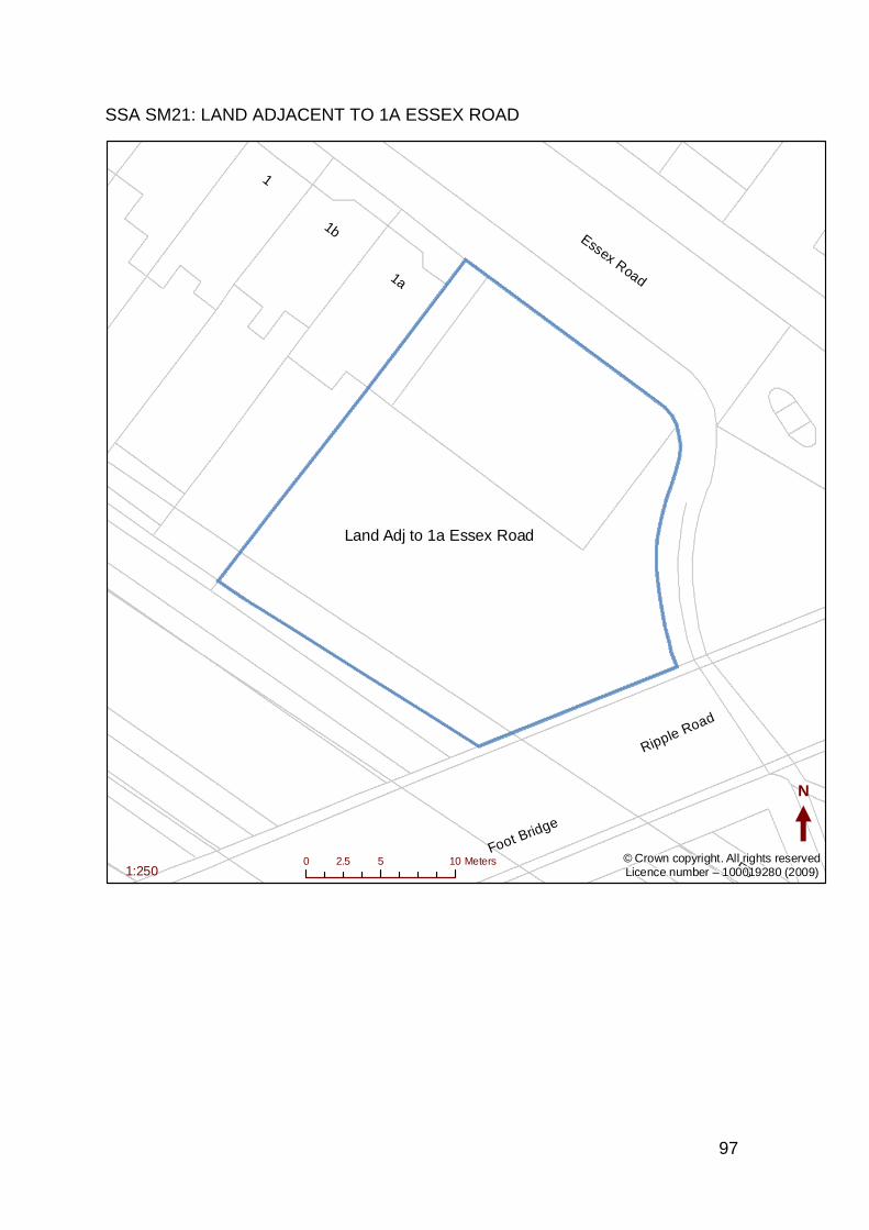
97
SSA SM21: LAND ADJACENT TO 1A ESSEX ROAD
Ripple Road
Essex Road1a
1b
1
Foot Bridge
FB
N
0 5 102.5 Meters1:250
© Crown copyright. All rights reservedLicence number – 100019280 (2009)
Land Adj to 1a Essex Road
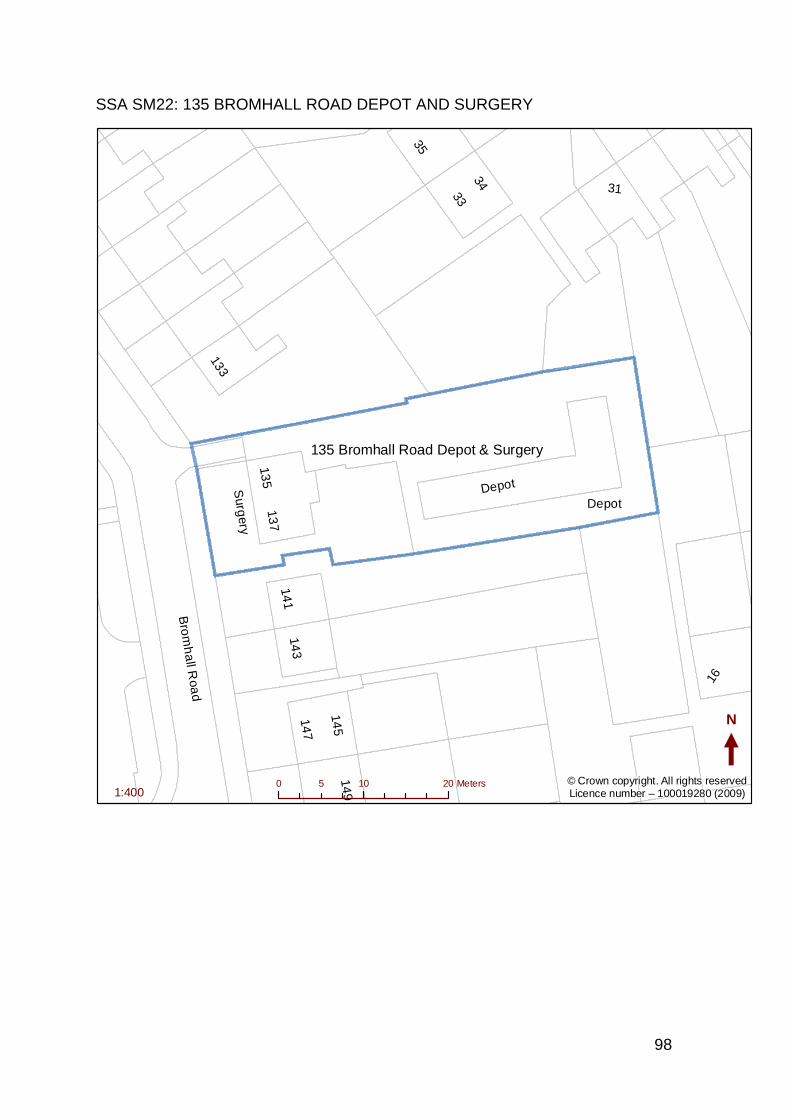
98
SSA SM22: 135 BROMHALL ROAD DEPOT AND SURGERY
Bro
mh
all R
oad
DepotSurg
ery
3133
35
133
135
34
16
143
145
137
141
147
149
Depot
N
0 10 205 Meters1:400
© Crown copyright. All rights reservedLicence number – 100019280 (2009)
135 Bromhall Road Depot & Surgery
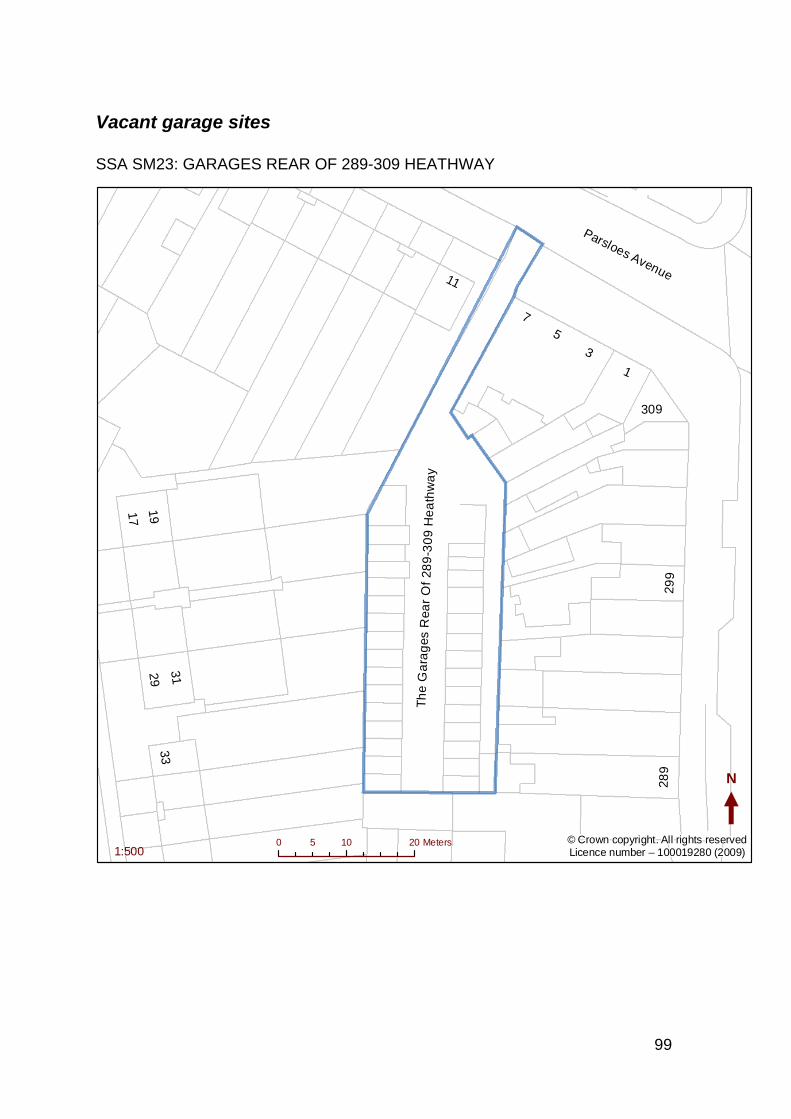
99
Vacant garage sites
SSA SM23: GARAGES REAR OF 289-309 HEATHWAY
Parsloes Avenue
Th
e G
ara
ges
Rea
r O
f 28
9-3
09
He
ath
wa
y
11
5
17
309
299
289
7
3331
3
1
1929
N
0 10 205 Meters1:500
© Crown copyright. All rights reservedLicence number – 100019280 (2009)
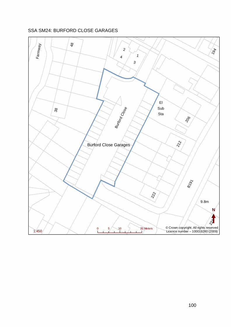
100
SSA SM24: BURFORD CLOSE GARAGES
B19
1
Bur
ford
Clo
se
Fa
rmw
ay
9.8m
1
222
212
2
206
48
221
194
3
384
Sub
Sta
El
N
0 10 205 Meters1:450
© Crown copyright. All rights reservedLicence number – 100019280 (2009)
Burford Close Garages
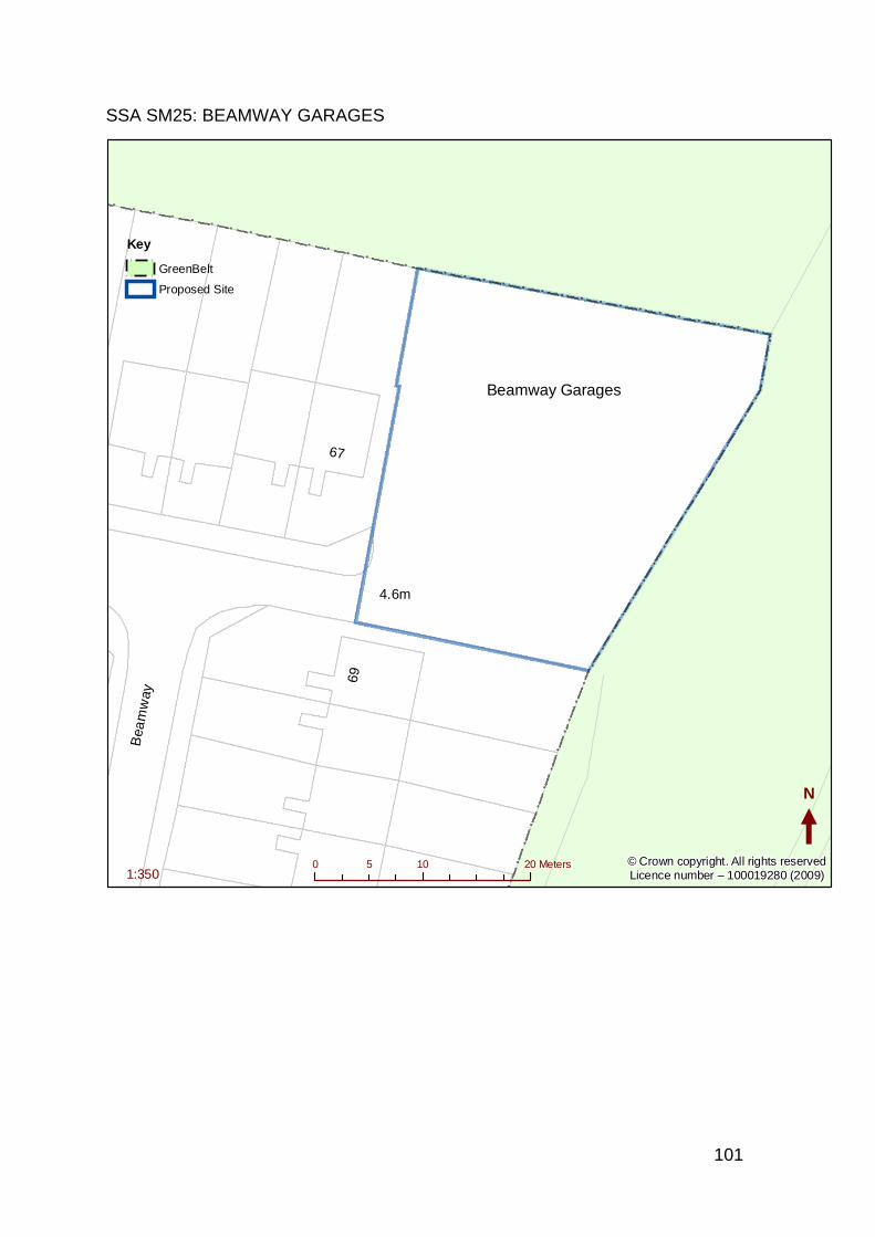
101
SSA SM25: BEAMWAY GARAGES
Bea
mw
ay
4.6m
69
67
N
0 10 205 Meters1:350
Key
!
! !
!! GreenBelt
Proposed Site
© Crown copyright. All rights reservedLicence number – 100019280 (2009)
Beamway Garages
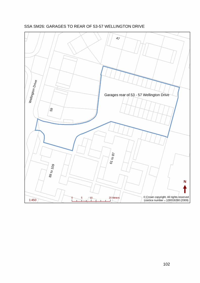
102
SSA SM26: GARAGES TO REAR OF 53-57 WELLINGTON DRIVE
Wel
ling
ton
Driv
e
89 t
o 10
9
61 t
o 87
59
47
N
0 10 205 Meters1:450
© Crown copyright. All rights reservedLicence number – 100019280 (2009)
Garages rear of 53 - 57 Wellington Drive
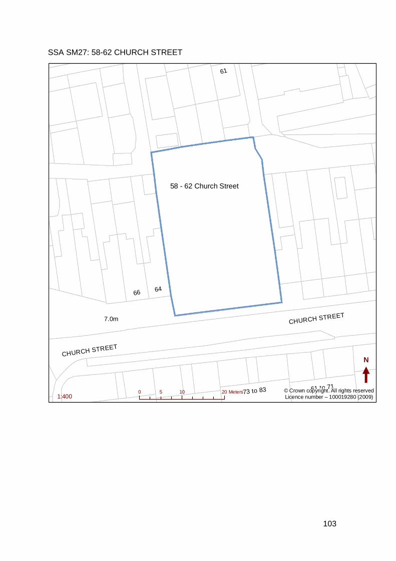
103
SSA SM27: 58-62 CHURCH STREET
CHURCH STREET
73 to 83
61
61 to 71
6466
7.0m
CHURCH STREET
N
0 10 205 Meters1:400
© Crown copyright. All rights reservedLicence number – 100019280 (2009)
58 - 62 Church Street
104
Garage Sites Still Occupied
SSA SM28: GARAGES REAR OF 13-15 HIGHLAND AVENUE, DAGENHAM
HIGHLAND AVENUE
15
N
0 5 102.5 Meters1:300
© Crown copyright. All rights reservedLicence number – 100019280 (2009)
Garages Rear of 13 - 27 Highland Avenue
105
SSA SM29: MELLISH CLOSE GARAGES
Ward Bdy
6
94
8
N
0 5 102.5 Meters1:400
© Crown copyright. All rights reservedLicence number – 100019280 (2009)
Mellish Close Garages
106
SSA SM30: GARAGES IN FRONT OF 58-61 ALFRED’S GARDENS
Alfreds Gardens
N
0 4 82 Meters1:300
© Crown copyright. All rights reservedLicence number – 100019280 (2009)
Garages in front of 58 - 61 Alfreds Gardens
107
SSA SM31: THORNHILL GARDENS GARAGES
Thornhill Gardens
Drain
FB
49 to 71
73 to 95
N
0 10 205 Meters1:500
© Crown copyright. All rights reservedLicence number – 100019280 (2009)
Thornhill Gardens Garages
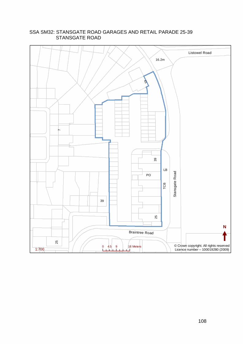
108
SSA SM32: STANSGATE ROAD GARAGES AND RETAIL PARADE 25-39 STANSGATE ROAD
Sta
nsga
te R
oad
Braintree Road
Listowel Road
16.2m25
39
7
41
LB
TC
B
PO
2539
N
0 9 184.5 Meters1:700
© Crown copyright. All rights reservedLicence number – 100019280 (2009)
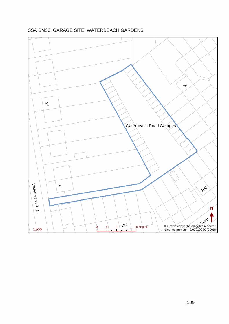
109
SSA SM33: GARAGE SITE, WATERBEACH GARDENS
Wa
terbe
ach
Roa
d
Rugby Road
2
122
12
108
86
N
0 10 205 Meters1:500
© Crown copyright. All rights reservedLicence number – 100019280 (2009)
Waterbeach Road Garages
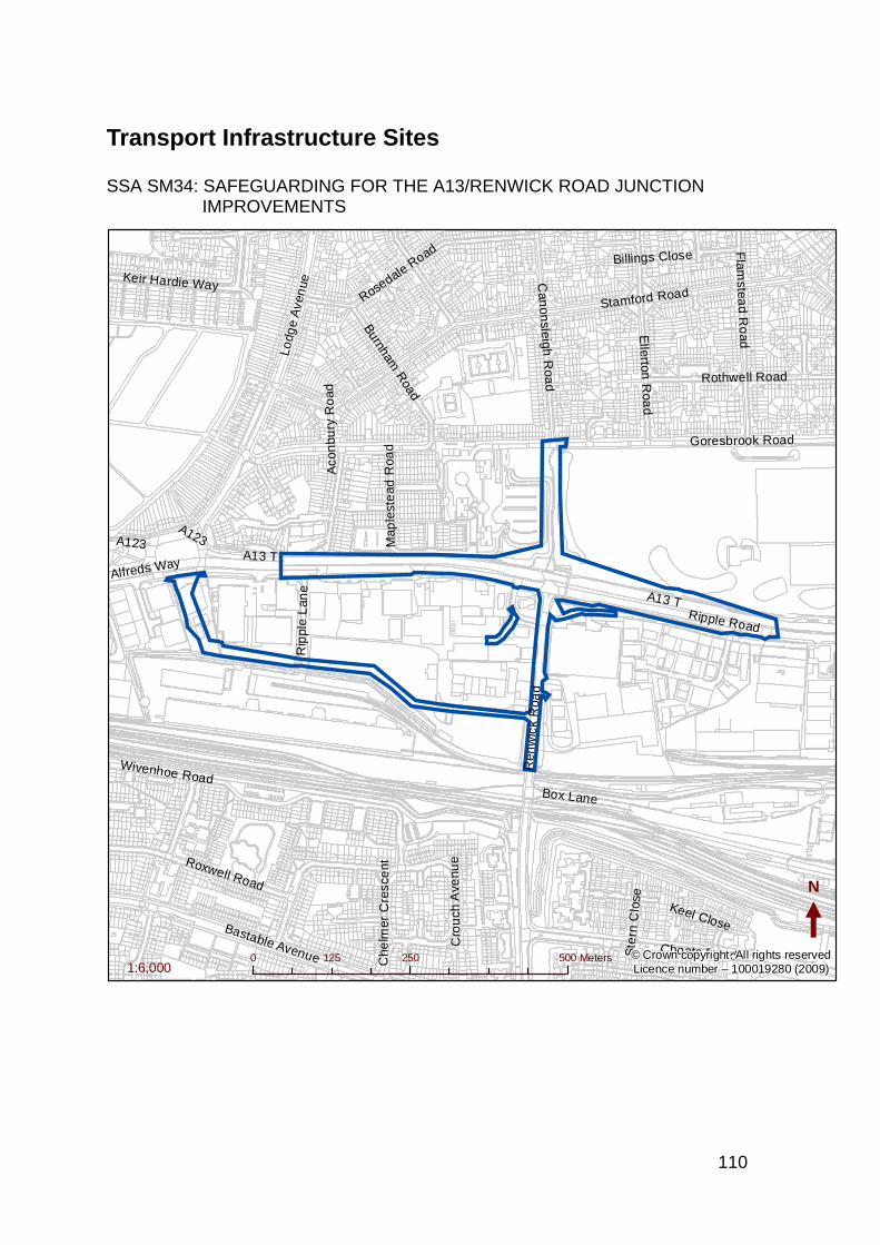
110
Transport Infrastructure Sites
SSA SM34: SAFEGUARDING FOR THE A13/RENWICK ROAD JUNCTION IMPROVEMENTS
A13 T
Stamford Road
Ren
wic
k R
oad
Ripple Road
Choats Road
Wivenhoe Road
Goresbrook Road
Bastable Avenue
Rosedale R
oadE
llerton R
oad
Roxwell Road
Rothwell Road
Flam
stead R
oad
Can
onsleigh
Roa
d
Lodg
e A
ven
ue
Box Lane
Burnham R
oad
Keir Hardie WayR
ippl
e L
ane
A123 Map
lest
ead
Roa
dC
h elm
e r C
resc
en t
Cro
uch
Ave
nue
Alfreds Way
Ste
rn C
lose
Keel Close
Aco
nbu
ry R
oad
Billings Close
A13 T
A123
N
0 250 500125 Meters1:6,000
© Crown copyright. All rights reservedLicence number – 100019280 (2009)
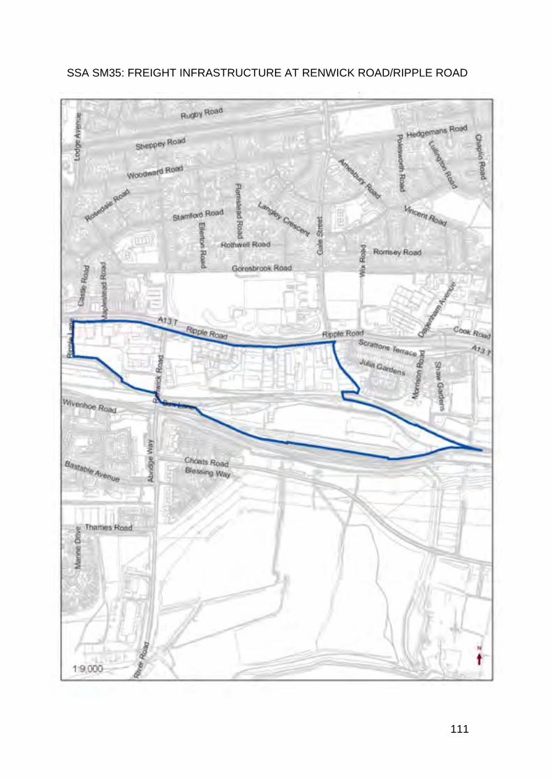
111
SSA SM35: FREIGHT INFRASTRUCTURE AT RENWICK ROAD/RIPPLE ROAD

112
SSA SM36: SAFEGUARDING FOR ELT1A AND 1B NB: MAP SHOWS END STATE ALIGNMENT. DASHED LINES WHERE NO EXISTING ROAD IN PLACE
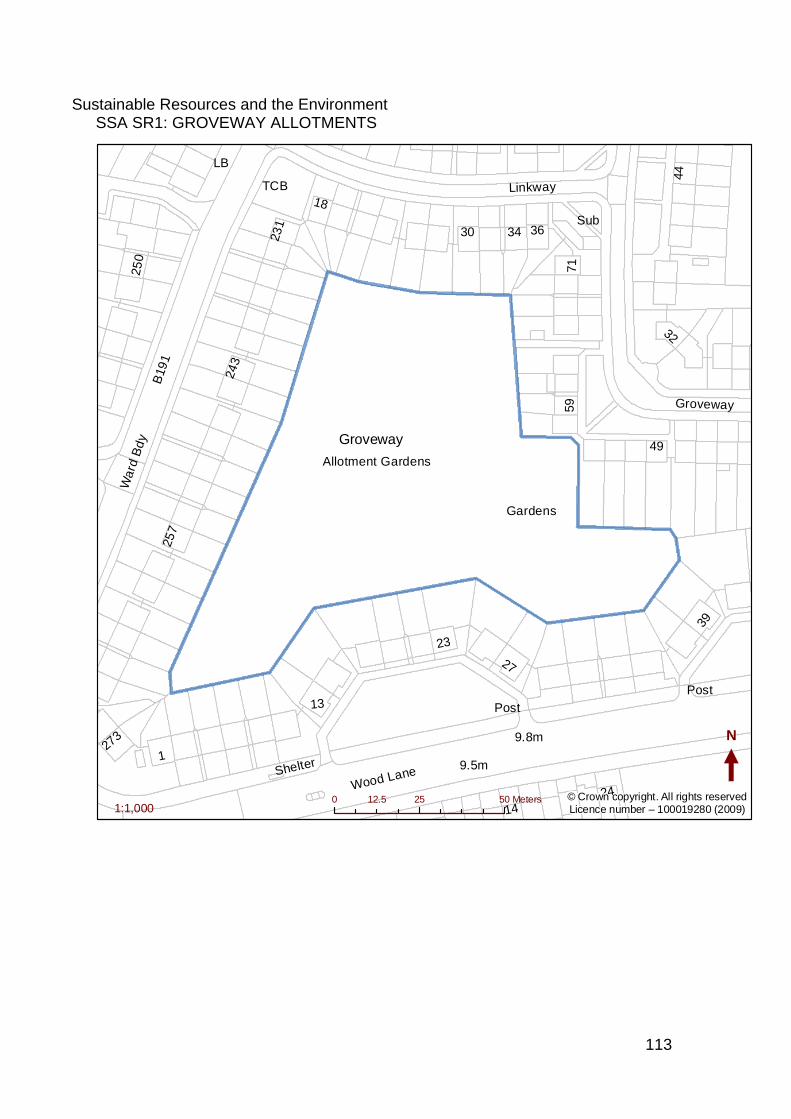
113
Sustainable Resources and the Environment SSA SR1: GROVEWAY ALLOTMENTS
B
191
Wood Lane
Linkway
Groveway
9.5m
9.8m
Gardens
Allotment Gardens
War
d B
dy
243
71
23
3634
250
44
257
13
49
27
231
18
59
30
14
39
32
127
3
24
Shelter
Sub
LB
Post
TCB
Post
N
0 25 5012.5 Meters1:1,000
© Crown copyright. All rights reservedLicence number – 100019280 (2009)
Groveway
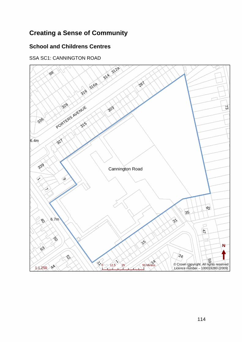
114
Creating a Sense of Community
School and Childrens Centres SSA SC1: CANNINGTON ROAD
6.7m
6.4m
PORTERS AVENUE
11 1
15
63
52
50
9
31
7
314
24
44
35
40
316a
73
316
303
14
287
336
26
45
59
339
47
326
312a
315
99
327
1
N
0 25 5012.5 Meters1:1,250
© Crown copyright. All rights reservedLicence number – 100019280 (2009)
Cannington Road
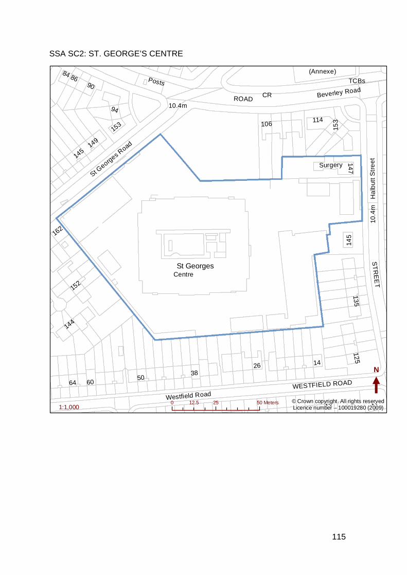
115
SSA SC2: ST. GEORGE’S CENTRE
Westfield Road
Ha
lbut
t Str
ee
t
Beverley Road
St Georg
es Road
10.4m
Centre
Surgery
ST
RE
ET
WESTFIELD ROAD
ROAD
114
Posts
64
94
90
106
60
162
13
123
149
152
86
144
125
145
26 14
135
153
50
84
147
38
TCBs
(Annexe)
CR
145
10.4
m
153
N
0 25 5012.5 Meters1:1,000
© Crown copyright. All rights reservedLicence number – 100019280 (2009)
St Georges
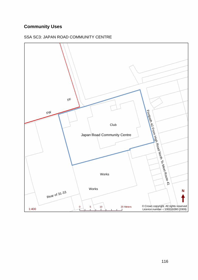
116
Community Uses
SSA SC3: JAPAN ROAD COMMUNITY CENTRE
Fo
otp
ath
42 F
rom
Hig
h Ro
ad N
orth
To M
ee
t Rou
te 41
Works
Club
FW
Rear of 31-33
FF
Works N
0 10 205 Meters1:400
© Crown copyright. All rights reservedLicence number – 100019280 (2009)
Japan Road Community Centre
117
SSA SC4: WHALEBONE LANE SOUTH
Purland Close
Wh
alebo
ne La
ne S
outh
A1112
Lamberhurst Road
Rosemary Gardens
Stanley Avenue
Wh
alebo
ne La
ne S
outh
Warehouse
Eldonwall Estate
16.8m
111117
Superstore
17
2
23
55
34
91
35
129
to 1
69
176
43
22
101
7a
175
127
171
186
14
13
21
31
28
12
136
160
She
lter
TCBs
ROAD
El Sub Sta
22
1
El Sub Sta
N
0 30 6015 Meters1:1,500
© Crown copyright. All rights reservedLicence number – 100019280 (2009)

118
Healthcare
SSA SC5: WESTBURY ARMS
Ripple Road
King E
dwards R
oad
St Margarets
PH
180186
182184
178176
174
2
4.8m
5.5m
N
0 10 205 Meters1:250
© Crown copyright. All rights reservedLicence number – 100019280 (2009)
Westbury Arms
119
SSA SC6: JULIA ENGWELL CLINIC
Sheppey RoadS
tam
ford
Ro
ad
Woodward Road
Woodward
Clinic
EngwellJulia
Hall
Library
Greig
7.0m
Depot
WOODWARD ROAD
11
4
29
36
31
41
9
2832
1
24
25
2
8
59
45
30
20
38
7
49
2634
33
Shelter
Hall
29
N
0 10 205 Meters1:800
© Crown copyright. All rights reservedLicence number – 100019280 (2009)
120
SSA SC7: BROCKELBANK LODGE
B191
Becontree Avenue
Haydon Road
Bennetts Castle Lane
B191
Becontree Avenue
Brockelbank
Lodge
12.8m
73
380
56
363 to 369
60
70
71
80
N
0 10 205 Meters1:600
© Crown copyright. All rights reservedLicence number – 100019280 (2009)
121
Barking Riverside
SSA SC8A: BARKING RIVERSIDE – STAGE 1 NEIGHBOURHOOD CENTRE
N
This map is reproduced from Ordnance Survey material with the permission of Ordnance Survey on behalf of the Controller of Her
Majesty’s Stationery Office © Crown copyright. Unauthorised reproduction infringes Crown copyright and may lead to prosecution
or civil proceedings. 100019280 (2009)
122
SSA SC8B: BARKING RIVERSIDE – STAGE 2 DISTRICT CENTRE
N
This map is reproduced from Ordnance Survey material with the permission of Ordnance Survey on behalf of the Controller of Her
Majesty’s Stationery Office © Crown copyright. Unauthorised reproduction infringes Crown copyright and may lead to prosecution
or civil proceedings. 100019280 (2009)
123
SSA SC8C: BARKING RIVERSIDE – STAGE 3 NEIGHBOURHOOD CENTRE
N
This map is reproduced from Ordnance Survey material with the permission of Ordnance Survey on behalf of the Controller of Her
Majesty’s Stationery Office © Crown copyright. Unauthorised reproduction infringes Crown copyright and may lead to prosecution
or civil proceedings. 100019280 (2009)
124
SSA SC8D: BARKING RIVERSIDE – STAGE 4 NEIGHBOURHOOD CENTRE
N
This map is reproduced from Ordnance Survey material with the permission of Ordnance Survey on behalf of the Control ler of Her
Majesty’s Stationery Office © Crown copyright. Unauthorised reproduction infringes Crown copyright and may lead to prosecution
or civil proceedings. 100019280 (2009)
125
Locally Significant Industrial Locations
SSA SE1: LYON’S BUSINESS PARK AND NEIGHBOURING EMPLOYMENT USES TO THE SOUTH
River R
oad
Bastable Avenue
Ch
arlton
Cre
scent
A13 TAlfreds Way
Waverley Gardens
Cu
rzon C
rescen
t
Lyon
Estate
Warehouse
May
es B
rook
Industrial
El Sub Sta
f
N
0 25 5012.5 Meters1:1,700
© Crown copyright. All rights reservedLicence number – 100019280 (2009)
Lyon Business Park
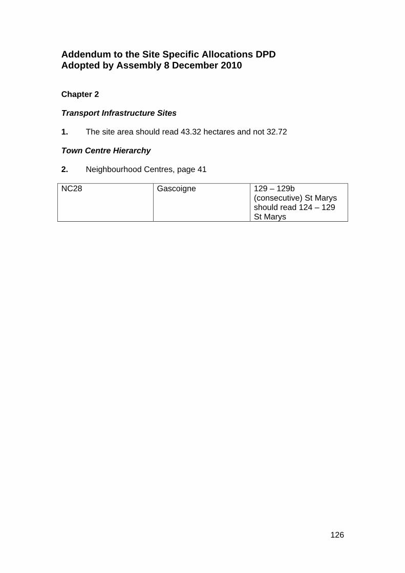
126
Addendum to the Site Specific Allocations DPD Adopted by Assembly 8 December 2010 Chapter 2 Transport Infrastructure Sites 1. The site area should read 43.32 hectares and not 32.72 Town Centre Hierarchy 2. Neighbourhood Centres, page 41 NC28 Gascoigne 129 – 129b
(consecutive) St Marys should read 124 – 129 St Marys

If you need help reading or understanding this document, please contact the Planning Policy Team Regeneration and Economic Development3rd Floor Maritime House 1 Linton RoadBarking, IG11 1HG Phone. 020 8215 3000Fax. 020 8227 3490Minicom. 020 8227 5755Email. [email protected] We will try to provide a reading service, a translation, large print, Braille or any other format you need.

London Borough of Barking and Dagenham Phone. 020 8215 3000
Out of hours emergencies only Phone. 020 8215 3024 Fax. 020 8227 3470 E-mail. [email protected] Website. www.barking-dagenham.gov.uk
We have tried to make sure that this information is correct at the time of going to print. However, information may change from time to time.
You must not copy this document without our permission. © 2008 London Borough of Barking and Dagenham.
Publication reference number: MC6361Date: January 2011
Printed on recycled paper. Published January 2011