Embed Size (px)
Citation preview

P.O. Box 20148 Perth, Ontario K7H 3M6 ph. 613-264-9600 fax: 613-264-9609 www.zanderplan.com Page 1
Planning Report and Aggregate Resources Act
Summary Statement
CANAAN QUARRY
East Half of Lot 14, Concession 1 Geographic Township of Cumberland
City of Ottawa, Ontario
Prepared for Cornwall Gravel Company Ltd.
By
ZanderPlan Inc. P.O. Box 20148 Perth, Ontario
K7H 3M6 (P) 613-264-9600 (F) 613-264-9609
www.zanderplan.com
File No. 13-054
May 19, 2016

P.O. Box 20148 Perth, Ontario K7H 3M6 ph. 613-264-9600 fax: 613-264-9609 www.zanderplan.com Page 2
Table of Contents
Canaan Quarry: Summary Report...……………………………………………………………………………….... 3
1.0 INTRODUCTION ………………………………………………………………………………………………………… 3
2.0 OVERVIEW OF THE SITE …………………………………………………………………………………………….. 3 2.1 The Site: Regional Context ……………………………………………………………………………………… 3 2.2 The Site: Immediate Context ………………………………………………………………………………….. 4 2.3 The Site: Existing Conditions …………………………………………………………………………………… 6 2.4 The Site: Aggregate Resources ……………………………………………………………………………….. 7
3.0 PLANNING AND LAND USE ………………………………………………………………………………………… 8 3.1 Provincial Policy Statement ……………………………………………………………………………………. 8 3.2 City of Ottawa Official Plan ……………………………………………………………………………………. 10 3.3 City of Ottawa Zoning By-law …………………………………………………………………………………. 11 3.4 Planning Approvals Required …………………………………………………………………………………. 13 3.5 Justification for the Amendment ……………………………………………………………………………. 13
4.0 AGRICULTURAL CLASSIFICATION ………………………………………………………………………………. 13
5.0 QUALITY AND QUANTITY OF AGGREGATE …………………………………………………………………. 16
6.0 TRAFFIC HAUL ROUTES ……………………………………………………………………………………………… 17
7.0 LAND USE COMPATIBILITY ………………………………………………………………………………………… 18
8.0 HYDROGEOLOGY ………………………………………………………………………………………………………. 20
9.0 NATURAL ENVIRONMENT REPORT ……………………………………………………………………………. 21
10.0 CULTURAL HERITAGE ASSESSMENT ………………………………………………………………………… 23
11.0 NOISE IMPACT ANALYSIS ………………………………………………………………………………………… 24
12.0 BLASTING IMPACT ANALYSIS …………………………………………………………………………………… 24
13.0 AGGREGATE RESOURCES ACT SUMMARY ………………………………………………………………. 25
14.0 CONCLUSION ………………………………………………………………………………………………………….. 27
15.0 WORKS CITED …………………………………………………………………………………………………………. 28

P.O. Box 20148 Perth, Ontario K7H 3M6 ph. 613-264-9600 fax: 613-264-9609 www.zanderplan.com Page 3
CANAAN QUARRY: SUMMARY REPORT _____________________________________________________________________________________
1.0 INTRODUCTION
Cornwall Gravel Company Ltd. (hereinafter referred to as the Owner) is making an application
for a Category 1 and Category 2, Class “A” Quarry Below the Water Table under the Aggregate
Resources Act. The quarry will be operated by Cornwall Gravel Company Ltd. based in Cornwall,
Ontario. The application will include an expansion of the existing Birch Quarry, a Class “A”
Quarry (ARA No. 4124), both to a greater depth and southward into an area already zoned as
Mineral Reserve (MR). An application to amend the Zoning By-law for the City of Ottawa, to
permit the proposed quarry expansion under an appropriate Mineral Extraction zone, will be
made concurrently with the license application to the Ministry of Natural Resources and
Forestry.
The following Summary Report has been prepared for the Owner by Tracy Zander, Registered
Professional Planner with ZanderPlan Inc. based out of Perth, Ontario. The Site Plans to support
the license application have been prepared by the Base Mapping Company Ltd. based in
Ottawa. The Level 1 & 2 Natural Environment Report were prepared by Bernie Muncaster of
Muncaster Environmental Planning Inc. based in Ottawa. The Stage 1 & 2 Archeological
Assessments were completed by Past Recovery Archeological Services based in Perth, Ontario.
The Hydrogeological Impact Assessment for the Expansion of Canaan Quarry was prepared by
Morrison Hershfield Ltd. out of their Ottawa Office. A Noise Impact Study for the proposed
quarry was completed by Aercoustics based in Toronto, Ontario. Finally, a Blasting Impact
Analysis was completed by Explotech based out of Ottawa.
2.0 OVERVIEW OF THE SITE
2.1 The Site: Regional Context
The site of the proposed quarry is located at 4000 Canaan Road, in the East Half of Lot 14,
Concession 1, Geographic Township of Cumberland, on the City boundary separating the City of
Ottawa from the City of Clarence-Rockland, which is in the United Counties of Prescott-Russell
(See Figure 1). The Village of Sarsfield is located approximately 4 kilometres west of the site and
the Village of Navan is approximately 10 kilometres west of the site. Approximately 3.5
kilometres to the east is the Village of Hammond and 3.5 kilometres to the southeast of the site
is the Village of Cheney, both located in the United Counties of Prescott-Russell.

P.O. Box 20148 Perth, Ontario K7H 3M6 ph. 613-264-9600 fax: 613-264-9609 www.zanderplan.com Page 4
Figure 1 – The Site: Regional Context
Canaan Road is a paved collector road in the City of Ottawa Official Plan Schedule G: Rural Road
Network, which runs along the border of the City of Ottawa and the City of Clarence-Rockland,
in the United Counties of Prescott-Russell. The site is approximately 2 kilometres south from
the intersection where Colonial Road (City of Ottawa) ends and Du Golf Road (Clarence-
Rockland, in Prescott-Russell) begins. Canaan Road terminates at the quarry site and resumes
approximately 500 metres from the southeast corner of the proposed expansion area. Traveling
north Canaan Road extends up to Highway 174 which travels along the Ottawa River through
the Village of Cumberland and into the urban areas of the City of Ottawa.
Several existing aggregate operations can be found in proximity to the proposed quarry. The
Cumberland Quarry, operated by R. W. Tomlinson Ltd, is found in the West Half of Lot 13,
Concession 1 abutting the site to the west in the United Counties of Prescott-Russell. Several
other aggregate operations can be found to the North, East, South and West, in both the City of
Ottawa and the United Counties of Prescott-Russell, suggesting the quantity of aggregate in the
area is significant.
2.2 The Site: Immediate Context
The immediate context of the site can be described as a mixture of woodlots and agricultural
fields with sparse rural residential properties. North of the site there are large tracts of

P.O. Box 20148 Perth, Ontario K7H 3M6 ph. 613-264-9600 fax: 613-264-9609 www.zanderplan.com Page 5
agricultural land buffered from the quarry by trees along the Canaan Hill (See Figure 2a). To the
east of the site a dense woodlot borders the east side of Canaan Road, buffering the quarry
from a large agricultural field fronting onto Nolan Road (See Figure 2b). To the south another
woodlot separates the quarry site from a livestock operation (See Figure 2c). The barn is
located closer to the Prescott-Russell Trail Link with open grazing fields between the barn and
the southern lot line of the quarry. Finally, to the west is another quarry, operated by R. W.
Tomlinson Ltd., known as the Cumberland Quarry. It has a Class “A” Licence and measures 27ha
in size. The southern boundary of the Cumberland Quarry borders another woodlot (See Figure
2d) which buffers the Canaan Quarry from some open agricultural fields. However, the entirety
of this woodlot is identified as a quarry according to the Ministry of Natural Resources Online
Aggregate Mapping. Though no extraction is evident, the Quarry, known as the Canaan II
Quarry, is owned and operated by R. W. Tomlinson Ltd and measures 20.7ha in size.
Figure 2a – View of Canaan Hill Looking southwest from the quarry entrance
Figure 2c – Southern Woodlot Buffer Looking SW on the site, photo from the Archeological
Assessment completed by Past Recovery
Figure 2b – Eastern field with woodlot buffer Looking west from Nolan Road
Figure 2d – Western field with woodlot buffer Looking east from the corner of Birchgrove Rd and
Watson Rd

P.O. Box 20148 Perth, Ontario K7H 3M6 ph. 613-264-9600 fax: 613-264-9609 www.zanderplan.com Page 6
2.3 The Site: Existing Conditions
The proposed quarry will be located on the same site as a currently operating quarry, known as
the Birch Quarry, which was opened in the early 1990s. The current licensed area for the quarry
(License #4124) is described as Part of Lot 14, Concession 1, Geographic Township of
Cumberland, now in the City of Ottawa. The site, located at 4000 Canaan Road, has been taken
over by Cornwall Gravel Company Ltd. with the intention of expanding the extraction area to a
deeper level as well as into the southern portion of the site immediately adjacent to the
licensed boundary.
The current extraction area, as well as areas of tree clearing for the quarry expansion, is clearly
evident when examining more recent aerial photography of the site (See Figure 3 & 4). The
original licensed area for the quarry was 19.2ha, but the existing extraction area is slightly less
at 16.2ha. Several vertical cuts are evident with extraction occurring primarily in the southern
and eastern portions of the current licensed area. The western portion of the quarry does have
some evidence of extraction, but not to the extent as seen to the south and east on the site. A
detailed Hydrogeological Analysis of the existing extraction area was completed by Morrison
Hershfield Ltd. to assess the impacts of expanding and deepening the quarry and its effect on
the existing vertical cuts (See Figures 5a - 5c).
Figure 3 – Aerial Photo of the existing quarry operation (November 10th, 2015)
Figure 4 – Aerial Photo of the Existing Quarry Operation (June 18th, 2015)
P.O. Box 20148 Perth, Ontario K7H 3M6 ph. 613-264-9600 fax: 613-264-9609 www.zanderplan.com Page 7
Figure 5a - Vertical Cut
Figure 5b – Newly exposed rock
Figure 5c – Vertical Fracturing Note: Photos derived from the Hydrogeological Impact Assessment completed by Morrison Hershfield Ltd.
The proposal will see the site expand southward to the line separating Lots 14 & 15, Concession
1. The proposed expansion has been completely cleared of vegetation and no longer houses
any trees. A Stage 1 & 2 Archeological Assessment was completed for the proposed expansion
area by Past Recovery Archeological Services with no evidence of significant artifacts present.
2.4 The Site: Aggregate Resources
In conducting their Hydrogeological Assessment of the site, Morrison Hershfield Ltd. notes that
“the study area is a limestone plain protruding from a clay plain or, towards the south, a sand
plain. The surrounding clay plain is generally described as the Ottawa Valley Clay Plain, while
the sand plain is the Prescott and Russell Sand Plain. The clay is glaciomarine clay, deposited by
the Champlain Sea, while the sand plain is a deltaic deposit of the Ottawa River.” The site
contains an east to west trending limestone deposit referred to as Canaan Hill, mapped as
Paleozoic bedrock. The bedrock is referred to as the Lindsay Formation. A description for the

P.O. Box 20148 Perth, Ontario K7H 3M6 ph. 613-264-9600 fax: 613-264-9609 www.zanderplan.com Page 8
Lindsay Formation can be found in the Limestone Industries of Ontario Volume I – Geology,
Properties and Economics, provided by the Ministry of Northern Development and Mines.
The Lindsay Formation
The Lindsay Formation in eastern Ontario consists of limestone, with thin calcareous
shale interbeds, which conformably overlies the Verulam Formation. Identifying the
contact between these two units in an outcrop can be difficult, but it is generally placed
where the shale interbeds (which characterize the Verulam Formation) become less than
5 cm thick. The Lindsay Formation is divisible into two members; the upper is called the
Eastview Member and the lower is unnamed. Portions of the Eastview Member are
equivalent to the well-known Collingwood shale, an oil shale which is exposed near
Craigleith, Ontario. A distinctive characteristic of the limestones of the lower member is
the highly undulating nature of the bedding which produces a nodular texture. The
limestones are microcrystalline to coarse crystalline, very thin to thick bedded and tend
toward grey-brown colours. Shale interbeds are calcareous and dark grey or dark brown
in colour. The Eastview Member consists of calcareous shale and exudes a petroliferous
odor from a fresh surface. The lower member is extensively used for general aggregate
production by the limestone industry. Distribution of the Lindsay Formation is generally
restricted to the Cornwall District.
Morrison Hershfield Ltd. goes on to state in their report that “the thickness of the lower
member of the Lindsay Formation varies from about 20 m in Ottawa to about 125 m near
Montreal. Linear interpolation would imply approximately 37 m thickness of the lower member
of the Lindsay Formation at the Canaan Quarry.” The quantity of aggregate on the site is
estimated to be 30 million tonnes. The material extracted may be used for asphalt, concrete,
roads and civil construction. The existing quarry is currently licensed to extract 500,000 tonnes
/ year. The expansion will see the quarry deepened by lowering the allowable floor elevation
from 84 to 60 metres above sea level, and increasing tonnage to 2 million tonnes / year.
3.0 PLANNING AND LAND USE
3.1 Provincial Policy Statement (2014)
The Provincial Policy Statement (PPS, 2014), issued under the authority of Section 3 of the
Planning Act, provides policy direction on matters of provincial interest related to land use
planning and development and provides for appropriate development while protecting
resources of Provincial interest. Section 2.5 of the PPS, 2014 outlines Mineral Aggregate

P.O. Box 20148 Perth, Ontario K7H 3M6 ph. 613-264-9600 fax: 613-264-9609 www.zanderplan.com Page 9
Resources policies stating “Mineral Aggregate Resources shall be protected for long-term use”
(Pg. 27, PPS, 2014) and identified where available information exists. The following aspects of
the Provincial Policy Statement with respect to the Cornwall Gravel Co. quarry Application
should be considered:
The Wise Use and Management of Resources refers to Ontario’s long-term prosperity,
environmental health, and social well-being being dependent upon protecting mineral
resources, among other things, for their economic, environmental and social benefits.
Section 2.5.2 expands on Mineral Aggregate Resources and the protection of their long-
term resource supply stating “as much of the mineral aggregate resources as is
realistically possible shall be made available as close to markets as possible” and that
“demonstration of need for mineral aggregate resources, including any type of
supply/demand analysis, shall not be required, notwithstanding the availability,
designation or licensing for extraction locally or elsewhere” (Sec. 2.5.2.1, PPS, 2014).
Extraction operations carry with them a number of potential impacts on abutting
properties which the Provincial Policy Statement recognizes under Section 2.5.2.2.
“Extraction shall be undertaken in a manner which minimizes social, economic, and
environmental impacts” (PPS, Pg. 27). The proposed quarry operation includes various
measures such as setbacks, fencing, berms and other features which will help to
minimize impacts on surrounding lands. These are detailed on the enclosed site plans.
The protection of the extraction operations is addressed in section 2.5.2.4 stating
“Mineral Aggregate Operations shall be protected from development and activities that
would preclude or hinder their expansion or continued use”.
In summary, the Provincial Policy Statement (2014) recognizes the significance of mineral
resources to the economy of Ontario. It sets in place policies designed to not only protect these
resources but to ensure their availability and contribution to the long-term prosperity of the
Province while minimizing social, economic and environmental impacts associated with
aggregate operations. The proposed quarry site is already an active aggregate operation. The
proposed lands for expansion are recognized for their aggregate potential through the Mineral
Reserve (MR) Zoning already in place in the City of Ottawa, with a proposed Zoning
Amendment to the Mineral Extraction (ME) zone. Accordingly, the proposed use of the subject
lands for a quarry is not only consistent with, but derives support from, the general intent and
policies of the Provincial Policy Statement.

P.O. Box 20148 Perth, Ontario K7H 3M6 ph. 613-264-9600 fax: 613-264-9609 www.zanderplan.com Page 10
3.2 City of Ottawa Official Plan
The City of Ottawa’s Official Plan 2003-203 provides policy direction concerning mineral
resources in section 3.7.4. Sand and Gravel, and Limestone Resource Areas are designated on
Schedule A and B of the Official Plan, with the subject lands falling under the Limestone
Resource Area designation (See Figure 6). Section 3.7.4.2 of the Official Plan notes that pits and
accessory uses to the aggregate extraction operation are the primary uses found on lands
designated Sand and Gravel. Additionally, Section 3.7.4.4 of the Official Plan notes that in
Limestone Resource Areas a quarry and underground mining are permitted uses in addition to
the uses found in Sand and Gravel Resource Areas.
Figure 6 – City of Ottawa Official Plan Schedule A – Rural Policy Plan
The City of Ottawa requires all pits and quarries that are licensed under the Aggregate
Resources Act to be zoned to permit mineral extractive use operations. This zoning requirement
is compulsory regardless of the Official Plan Designation on the property. Prior to the
establishment of any new pit or quarry, the City requires lands be re-zoned to permit mineral
extractive use, for both new pits and quarries or proposed expansions to existing ones. Section
3.7.4.9 introduces the concept of influence areas around aggregate operations. Quarries carry
P.O. Box 20148 Perth, Ontario K7H 3M6 ph. 613-264-9600 fax: 613-264-9609 www.zanderplan.com Page 11
an influence area of 500m, pits with extraction below the water table have an influence area of
300m, and pits above the water table are 150m.
The Blasting Impact Analysis completed by Explotech concluded there are three sensitive
receptors that fall within 500m of the proposed quarry:
1. 69/147 Belvedere Court - 260m to the Southwest
2. 4169 Birchgrove Road - 360m to the South
3. 2838 Nolan Road - 475m to the Northeast
As the quarry operation migrates southward across the property the distance to these three
sensitive receptors is subject to change. According to the Blasting Impact Analysis, limestone
quarries in Ontario normally employ 76 to 150mm diameter blast holes. Current practice at the
existing quarry employs 89 to 102mm blast holes. The report states “while current practices
would be acceptable for the initial blasting in the extension area, calculations contained within
this report suggest modifications to current blast designs may be necessary as operations
progress towards adjacent receptors. Fortunately, given advanced initial separation distances
between blasting operations and neighbouring receptors, there exists ample opportunity for
data collection and analysis prior to any required blasting in closer proximity to the adjacent
receptors.” Based on the policies found in the City’s Official Plan Section 3.7.4 and the Blasting
Impact Analysis Report completed by Explotech, the proposed quarry operation conforms to
the Official Plan policies and objectives regarding mineral resources.
3.3 City of Ottawa Zoning By-Law
The subject lands presently have dual zoning within the City of Ottawa’s Zoning By-Law. The
northerly portion of the site is zoned Mineral Extraction (ME) and currently contains the
existing quarry operation. The purpose of the ME Zone is to permit licenced mineral extraction
operations in areas mainly designated as Sand and Gravel Resource Area or Limestone
Resource Area, while allowing a limited range of permitted uses relating to mineral extraction.
The southerly portion of the site, where expansion of the quarry is proposed, is currently zoned
Mineral Reserve (MR) (See Figure 7). The MR Zone recognizes lands designated Sand and Gravel
Resource Area or Limestone Resource Area in the City’s Official Plan and protects these
aggregate resources until such time that re-zoning to permit extraction operations has
commenced. The MR Zone extends south into Lot 15 up to the Prescott-Russell Trail Link.

P.O. Box 20148 Perth, Ontario K7H 3M6 ph. 613-264-9600 fax: 613-264-9609 www.zanderplan.com Page 12
Figure 7 – Zoning for the Subject Property and Abutting Land Uses
An amendment to the City of Ottawa Zoning By-law is required for the portion of the subject
property zoned Mineral Reserve (MR) in order to permit the expansion of the existing quarry
over the entirety of the site. The amendment will request the southern portion be re-zoned
from the Mineral Reserve (MR) Zone to the Mineral Extraction (ME) Zone. Section 54 of the
City’s Zoning By-Law defines a quarry as:
Quarry means land or land under water from which consolidated aggregate is being or has
been excavated, and that has not been rehabilitated, but does not include a wayside quarry.
A Zoning Amendment application will be submitted to the City of Ottawa concurrently with the
Quarry Application under the Aggregate Resources Act to the Ministry of Natural Resources and
Forestry.

P.O. Box 20148 Perth, Ontario K7H 3M6 ph. 613-264-9600 fax: 613-264-9609 www.zanderplan.com Page 13
3.4 Planning Approvals Required
As noted above, the proposed quarry is consistent with the designation and uses permitted in
the City of Ottawa’s Official Plan. An amendment to the City’s Zoning By-law is required to
place the southern portion of the property into the Mineral Extraction (ME) zone in order to
permit the expansion of the existing quarry. The Zoning Amendment application will be
submitted concurrently with the quarry license application to the Ministry of Natural Resources
and Forestry.
3.5 Justification for the Amendment
The existence of aggregate material in this area of the City is already recognized through the
Limestone Resource Area designation of the Official Plan Schedule A: Rural Policy Plan and
through the Mineral Extraction and Mineral Reserve Zones as found in the City’s Zoning By-law.
Furthermore, the site already houses an existing quarry operation with an additional quarry
operation, known as the Cumberland Quarry, abutting the property to the west. The proposed
expansion will utilize mineral reserves on the same site as an existing extraction operation,
utilizing the roads and extraction methods already in place. The proposed quarry is consistent
with the policies of the Provincial Policy Statement (2014) and an example of good land use and
planning practices.
4.0 AGRICULTURAL CLASSIFICATION
According to the Canada Land Inventory (CLI) Soil Capability for Agriculture 2012 mapping,
prepared by the Ontario Ministry of Agriculture, Food and Rural Affairs, the subject property is
comprised mainly of non-prime agricultural land (See Figure 8). The northeast tip of the
property has a small amount of Prime Agricultural Land, but not enough to support an
agricultural operation. Non-prime agricultural soils are comprised of Soil Classes 4 through 7
and are classified as having severe limitations on crop growth. Prime Agricultural Land is
comprised of Soil Classes 1 through 3 ranging from moderate to no significant limitations on
crop growth. The Provincial Policy Statement (2014) offers protection for Prime Agricultural
Areas in Section 2.3, stating in Section 2.3.1:
Prime agricultural areas shall be protected for long-term use for agriculture.

P.O. Box 20148 Perth, Ontario K7H 3M6 ph. 613-264-9600 fax: 613-264-9609 www.zanderplan.com Page 14
Prime agricultural areas are areas where prime agricultural lands predominate. Specialty
crop areas shall be given the highest priority for protection, followed by Canada Land
Inventory Class 1, 2 and 3 lands, and any associated Class 4 through 7 lands within the
prime agricultural area, in this order of priority.
Figure 8 – 2012 CLI Soil Capability for Agriculture Mapping
The northeast corner of the subject property is classified as prime agricultural lands, but the
majority of the site, including the proposed expansion area, is classified as Classes 4 – 7. To the
north of the property are large tracts of agricultural fields, separated from the quarry by a row
of trees along Canaan Hill. Though the CLI mapping shows a very small amount of prime lands in
the northeast corner of the site the topography, natural features and the quarry entrance at
the end of Canaan Road would prohibit agricultural operations in that location.
The 2012 CLI Soil Capability for Agriculture mapping shows in a simple context that the subject
property consists of non-prime agricultural land. However, the 2012 CLI mapping groups these
non-prime soils into one category and does not expand on what classes, and subsequent
subclasses, are present in the soils of the site. The 2009 CLI Soil Capability for Agriculture
mapping provides much greater detail by separating each class individually and expanding on
P.O. Box 20148 Perth, Ontario K7H 3M6 ph. 613-264-9600 fax: 613-264-9609 www.zanderplan.com Page 15
the various subclasses and the makeup of soil complexes present. For reference, a soil complex
is a mapping unit used to denote the distribution of soils when soils of different types are mixed
in a way that makes it difficult to show separately at larger scales on a map.
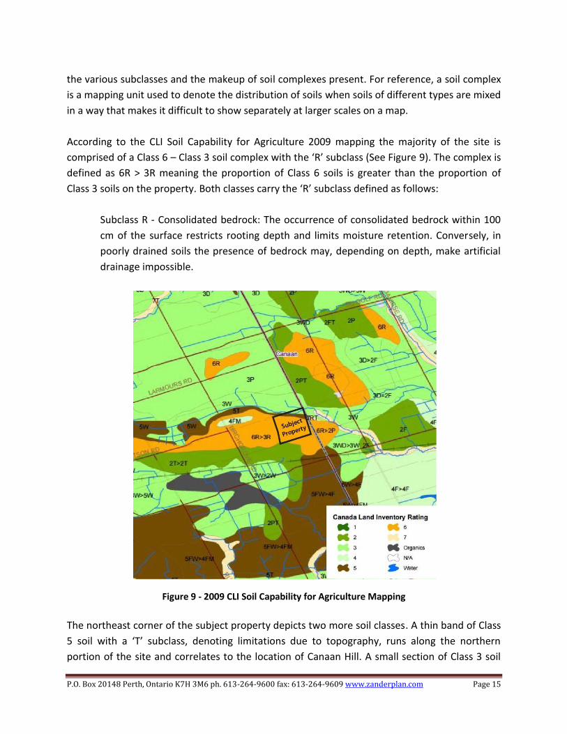
According to the CLI Soil Capability for Agriculture 2009 mapping the majority of the site is
comprised of a Class 6 – Class 3 soil complex with the ‘R’ subclass (See Figure 9). The complex is
defined as 6R > 3R meaning the proportion of Class 6 soils is greater than the proportion of
Class 3 soils on the property. Both classes carry the ‘R’ subclass defined as follows:
Subclass R - Consolidated bedrock: The occurrence of consolidated bedrock within 100
cm of the surface restricts rooting depth and limits moisture retention. Conversely, in
poorly drained soils the presence of bedrock may, depending on depth, make artificial
drainage impossible.
Figure 9 - 2009 CLI Soil Capability for Agriculture Mapping
The northeast corner of the subject property depicts two more soil classes. A thin band of Class
5 soil with a ‘T’ subclass, denoting limitations due to topography, runs along the northern
portion of the site and correlates to the location of Canaan Hill. A small section of Class 3 soil

P.O. Box 20148 Perth, Ontario K7H 3M6 ph. 613-264-9600 fax: 613-264-9609 www.zanderplan.com Page 16
with a ‘W’ subclass, denoting excess water, is located in the northeast corner and correlates
with the small region of Class 3 soils as seen in the 2012 CLI Soil Capability for Agriculture
mapping. Based on the majority of the site being non-prime agricultural soils, the presence of
subclasses for consolidated bedrock (R), topography (T), and excess water (W), and the existing
quarry operation on site the property is not suitable for an agricultural operation. The benefit
of allowing a quarry operation outweighs the need for protecting the site for agricultural use.
As the subject lands are not identified with prime agricultural lands nor is this considered a
prime agricultural area, the extraction of aggregate from the site would be consistent with the
policies in the Provincial Policy Statement (2014).
5.0 QUALITY AND QUANTITY OF AGGREGATE
The proposed site has three different soil types present as outlined in the Soils of the Regional
Municipality of Ottawa-Carleton Map 1, published by the Land Reserve Research Centre,
Research Branch, Agriculture (See Figure 10).
Figure 10 – The Soils of the Regional Municipality of Ottawa – Carelton (found online at http://sis.agr.gc.ca/cansis/publications/surveys/on/on58/index.html)

P.O. Box 20148 Perth, Ontario K7H 3M6 ph. 613-264-9600 fax: 613-264-9609 www.zanderplan.com Page 17
The subject property’s soil landscape consists mainly of a compound landscape of Farmington
(F) Soils and Grenville (G) Soils, characterized as stony sandy loam, fine sandy loam, sandy loam
or loam. The Farmington Soils make up the more dominant of the two types present. This F/G
complex is further described as being moderately stony (0.1 - 3.0% surface stones) to very stony
(3.0 - 15.0% surface stones) that is nearly level to gently sloping throughout the site. This
complex comprises the majority of the current extraction area to the north of the property and
the entirety of the area proposed for expansion and the south end of the property.
Positioned north of the Farmington – Grenville Soil Complex is a thin strip designated as
Escarpment (X3), comprised of steeply to very steeply inclined clay, sand, or bedrock with
slopes greater than 15%. The band of escarpment soils falls to the north of the current
extraction area on the site. To the north of the escarpment band, at the northeast tip of the
property, lies a flat area comprised of Dalhousie (D) soils, described as gray neutral silty clay or
clay marine material. The current entrance for the Canaan Quarry falls over these Dalhousie
Soils and they are not included as part of the extraction area.
The estimated quantity of aggregate material on the site is 30 million tonnes. The original
quarry license permitted an annual tonnage of 250,000, increased through an Amendment in
2001 to 500,000 tonnes / year. Cornwall Gravel Company Ltd. is proposing an annual tonnage
of 2,000,000 tonnes / year under the new licence.
6.0 TRAFFIC HAUL ROUTES
Truck traffic will enter and exit the property via the northern branch of Canaan Road, which
terminates at the quarry entrance. From Canaan Road, trucks will travel in several directions
depending on where the demand for aggregate is and where specific projects are located. No
dominant haul route or direction is anticipated. Trucks could travel west along Colonial Road
(County Road 28) to access east Ottawa, north from Colonial Road along Dunning Road (County
Road 35) to access Cumberland, west into the United Counties of Prescott-Russell via Du Golf
Road (County Road 1) or north toward Clarence-Rockland using County Road 21. In each
instance the trucks will be able to follow County Roads in order to reach their destinations.
The new quarry licence would permit extraction up to 2,000,000 tonnes / year. Aggregate will
be transported by both tri axle dump trucks, with an average payload of 20 tonnes, and trailers
with an average payload of 32 tonnes. Traffic volume calculations assume operations will be

P.O. Box 20148 Perth, Ontario K7H 3M6 ph. 613-264-9600 fax: 613-264-9609 www.zanderplan.com Page 18
conducted for 12 months or 250 working days. Therefore, the following trips / hour can be
anticipated for the two transport vehicles:
Tonnes moved / day = 2,000,000 tonnes/year / 250 days/year
= 8,000 tonnes/day
Tri Axle Loads = (8,000 tonnes/day / 20 tonnes/vehicle) / 12 hours/day
= (400 vehicles/day) / 12 hours/day
= 33.3 vehicles/hour
Or
Trailer Loads = (8,000 tonnes/day / 32 tonnes/vehicle) / 12 hours/day
= (250 vehicles/day) / 12 hours/day
= 20.8 vehicles/hr
Therefore, for 20 tonne triaxle and 32 tonne trailer loads, the number of loads generated at
peak hours would be 33.3 and 20.8 loads/hour respectively.
Based on the calculations above it is not anticipated for the roads system surrounding the
quarry to be affected by truck traffic.
7.0 LAND USE COMPATIBILITY
The subject property is located in an area consisting mainly of rural and agricultural properties
with several existing quarries within two kilometres (See Figure 11). The subject property, along
with land abutting to the east and northeast, are zoned for Mineral Extraction (ME). Lands
abutting the property to the north and south, along with lands to the west and northwest are
zoned Mineral Aggregate Reserve (MR). Additionally, the parcel abutting Watson Road to the
north and Birchgrove Road to the west is zoned Mineral Aggregate Reserve 1 (MR-1) with the
exception zoning to permit a dwelling. All of these Mineral Extraction and Mineral Reserve
zones correlate to the area designated Limestone Resource Area in the City’s Official Plan
Schedule A. Within Prescott-Russell, another large quarry measuring 72.35ha is located along
Nolan Road, referred to as the Nolan Quarry. Several other examples can be found within 6km
of the site, as seen from the Ministry of Natural Resources and Forestry's Pits and Quarries
online mapping (See Figure 12), making this region a predominant source of aggregate material.

P.O. Box 20148 Perth, Ontario K7H 3M6 ph. 613-264-9600 fax: 613-264-9609 www.zanderplan.com Page 19
Figure 11 – 2km Analysis of Surrounding Uses (produced by ZanderPlan Inc.)
Figure 12 – Pits and Quarries in the Vicinity of the Subject Property (derived from the Ministry of Natural Resources online Aggregate mapping)

P.O. Box 20148 Perth, Ontario K7H 3M6 ph. 613-264-9600 fax: 613-264-9609 www.zanderplan.com Page 20
Several sensitive receptors have been identified within the 2km analysis of the quarry, but only
three of those receptors fall within 500m of the proposed extraction area boundary. The
distances were derived from the extraction area limits, as opposed to the boundary of the
property, as the main noise and vibrational effects, being the blasting of aggregate material, are
produced within the extraction area itself. The three sensitive receptors are 69/147 Belvedere
Court, 4169 Birchgrove Road and 2838 Nolan Road.
The subject property is bounded on all sides by thick vegetation acting as a buffer for some of
the noise created, as well as providing a visual barrier. In total, only three properties located at
#3744/3750, #3672 and #3636 Canaan Road are located between the site and Colonial Road
(County Road 28) limiting the amount of traffic expected to travel this section of Canaan Road.
The road itself is not continuous, terminating at the site and then resuming south of the
Prescott-Russell Trail Link. Therefore, Canaan Road is not a through-road meaning that traffic
will be minimized to those vehicles accessing the addresses listed and the subject property.
Overall, the proposed quarry operation and expansion is compatible with other aggregate
operations in the area, as well as the various agricultural and rural uses in the vicinity of the
site. Though some residential uses are located within 500m of the licensed extraction area the
planned berms combined with tree screening will provide a buffer between quarry operations
and surrounding sensitive uses. As the quarry expands south on the property the blast designs
for the removal of aggregate will be re-visited and adjusted accordingly to minimize the effects
blasting may have on surrounding uses.
8.0 HYDROGEOLOGY
A Hydrogeological Impact Assessment for the Expansion of the Cornwall Gravel Canaan Quarry
was completed by Morrison Hershfield Ltd. in April 2015 with site work completed in June of
2014. The assessment was necessary to evaluate the hydrogeological impacts of expanding the
quarry in a southerly direction to the line separating Lots 14 & 15, as well as deepening the
floor elevation from 84 metres to 60 metres above sea level. The assessment included
“background data review, site and area inspections, drilling of five boreholes, hydraulic testing
of open holes, groundwater level monitoring, groundwater sampling and analysis, and domestic
well survey, sampling and analysis. The study also included data synthesis, predictive analysis of
drawdown cone propagation, impact assessment, and proposal of monitoring and contingency
plans.”

P.O. Box 20148 Perth, Ontario K7H 3M6 ph. 613-264-9600 fax: 613-264-9609 www.zanderplan.com Page 21
The assessment showed a large basal aquifer on the north and east sides of the site which
provides water to many residences in the area. Given its high permeability any downdraw
would propagate significantly through the area. However, between the aquifer and extraction
area is Canaan Hill composed of limestone bedrock with a very low permeability, shown in the
recovery rates during the assessment. The report concludes that “so long as a sufficient column
of this rock remains between the extraction area and the basal aquifer, there will be negligible
interaction between the two, and the basal aquifer will be unaffected.” A 30m buffer below
80m above sea level (asl) of un-extracted bedrock will remain on the north side of the
extraction area to address this concern.
The results of the assessment indicate the expansion and deepening of the quarry has potential
to impact some of the shallower wells in the area, most notably those wells north of Magladry
Road and Belvedere Road. Biannual monitoring is recommended to monitor groundwater
lowering and allow for mitigation if lowering is too great. A contingency plan is recommended
in the instance any wells are negatively impacted by the proposed expansion. The proposed
contingency plan is as follows:
If a water well interference complaint is received by Cornwall Gravel, either directly or
through other channels (i.e., the MNR or MOECC), and the complaint concerns a water
well within 500 m of the licensed area, then Cornwall Gravel will:
1. Immediately provide an interim potable water supply (within 12 hours);
2. Notify the MOE of the complaint (if they are not already aware);
3. Retain a qualified professional to conduct a site investigation, determine the cause
and provide recommendations to correct the problem; and,
4. If it is found that the water well interference resulted from Cornwall Gravel
dewatering and quarry operations, the water supply will be restored to its original
condition, or better. Well deepening is a viable option in this area for restoration of
water quantity, and standard treatment systems are viable for restoration of water
quality in the event that deepened wells require this.
9.0 NATURAL ENVIRONMENT REPORT
A Level 1 and 2 Natural Environment Report was completed for the proposed quarry extension
by Muncaster Environmental Planning Inc. Field surveys were completed by Bernie Muncaster
on August 29th, 2014, May 27th, 2015 & July 3rd, 2015. Shaun St. Pierre, a certified Butternut

P.O. Box 20148 Perth, Ontario K7H 3M6 ph. 613-264-9600 fax: 613-264-9609 www.zanderplan.com Page 22
Assessor, visited the site July 23rd, 2015 analyzing Butternut Trees found on an adjacent to the
site.
The Level 1 and 2 analyses showed no Significant Wetlands, Fish Habitat, Significant
Valleylands, Significant ANSIs or Significant Wildlife Habitat on or within 120m of the site. The
analysis did reveal portions of the habitat of endangered and threatened species relating to the
Butternut Trees identified on and adjacent to the site. The analysis also showed the possibility
of Significant Woodlands to the west of the site but none on the proposed expansion area. In
total, 18 Butternut trees were assessed with 15 of those found to be healthy. The expansion
would remove 12 of these healthy Butternuts with the remaining three potentially harmed by
the expansion.
A detailed analysis of the Ewart Watson Municipal Drain, a tributary to North Indian Creek
located approximately 360m north of the northeast corner of the proposed expansion, was
completed to assess for Fish Habitat. Two stations were set up for sampling and tested on April
29th, 2015 and August 18th, 2015 yielding several varieties of fish including, but not limited to,
Central Mudminnow, Creek Chub, Brook Stickleback and Johnny Darter. Two tributaries to the
Ewart Watson Municipal Drain were also analyzed, but no sampling was conducted in either
tributary due to lack of water. Other than the identified municipal drain and its two tributaries,
no other channels with potential aquatic habitat were observed.
The potential impacts identified from the proposed quarry expansion would be water quality
and quantity, impacts on aquatic habitat, and possible impacts on significant woodlands
abutting to the west. To mitigate impacts to the water and fish habitat, a proposed 30 metre
buffer of bedrock (below 80m asl) is recommended (by Morrison-Hershfield) on the north side
of the extraction area. Including the buffer, the distance across the pillar of remaining bedrock
to the basal aquifer would be approximately 160 metres, enough to ensure the quality of water
is not impacted. Any future dewatering of the quarry would be subject to approvals from
MOECC.
In terms of the Butternut Trees on-site, to mitigate for the trees slated for removal, 30 pure
Butternut plantings will be located elsewhere on-site or at an approved off-site location. No
Butternut trees will be removed until the proper permits have been obtained. For the
Significant Woodlands falling on the adjacent property to the west, they are located in an area
licensed under ARA #4143 and #608401 for mineral extraction and could be removed at the
point when extraction starts on this site. Where a berm is not already present, the extraction
area and setbacks should be delineated with all disturbances confined within the extraction
area to allow adjacent trees to be protected.

P.O. Box 20148 Perth, Ontario K7H 3M6 ph. 613-264-9600 fax: 613-264-9609 www.zanderplan.com Page 23
Based on the lack of significant heritage features present on and around the proposed
expansion, the Level 1 and 2 Natural Environment Report concludes that any natural heritage
features found on or around the site will be protected. The removal of 15 healthy Butternut
Trees and the placement of 30 new plantings will result in an overall benefit for the species
provided mitigation measures are properly implemented.
10.0 CULTURAL HERITAGE ASSESSMENT
A Stage 1 & 2 Archaeological Assessment was completed for the quarry by Past Recovery
Archaeological Services based in Perth, Ontario. The Stage 1 Assessment was to identify known
heritage sources and determine archaeological potential for the site. The Stage 2 Assessment
was to determine if any archaeological resources, artifacts or sites with cultural heritage value
were present and determine whether any resources, if found, required further assessment.
Based on the results from historical research and available records the Stage 1 Assessment had
the following recommendations:
1. All portions of the study area have been determined to exhibit archaeological potential
and will require a Stage 2 archaeological assessment undertaken by a provincially
licensed archaeologist prior to any soil disturbances or other alterations.
2. As per MTCS requirements, all areas of archaeological potential should be assessed by
means of a shovel test pit survey conducted at five metre intervals.
The Stage 2 Assessment was undertaken on August 28th, 2014 covering the entire study area.
Testing was focussed on areas with fallen trees, brush piles or exposed bedrock with test pits
placed at 5 metre intervals wherever possible. The Assessment states “no artifacts, features or
other cultural deposits of archaeological concern were noted during the Stage 2 Assessment."
The recommendations subsequent to the Stage 2 Assessment are as follows:
1. No further archaeological assessment for the subject area as presently defined is
required. As a result, clearance of the archaeological condition placed on this
development should be granted.

P.O. Box 20148 Perth, Ontario K7H 3M6 ph. 613-264-9600 fax: 613-264-9609 www.zanderplan.com Page 24
11.0 NOISE IMPACT STUDY
A Noise Impact Study was completed by Aercoustics, based out of Toronto, to provide noise
control recommendations to ensure the quarry satisfies the Ontario Ministry of the
Environment and Climate Change (MOECC) noise guidelines. Noise limits were determined for
the residential receptors before noise predictions for the quarry operation were performed at
these receptors. If levels were predicted to exceed MOECC limits noise control measures were
recommended.
The study recommended that loading and shipping of material had no restrictions but those
processes involved in full operation, being extraction, processing and rock drilling should occur
only between the hours of 7am to 7pm, Monday to Sunday. Furthermore, the extraction,
processing and shipment equipment operating in the quarry is limited to:
1. One (1) Processing Plant
2. Two (2) Extraction Loaders
3. Two (2) Shipment Loaders
4. One (1) Rock Drill
5. 40 Highway truck trips/hr – assumed worst case 1hr volume
The study also recommended “prior to extraction of the newly licensed area of extraction, an
acoustic barrier shall be installed to a height of 106m a.s.l. along the south property line,
returning 100 m north along the east property line, and shall remain for the project lifetime."
Several other recommendations can be found under Section 5.3, pages 7-9 of the Aercoustics
Noise Impact Study. With the implementation of the recommended noise controls, the
proposed quarry operation is predicted to satisfy all MOECC guidelines.
12.0 BLASTING IMPACT ANALYSIS
A Blasting Impact Analysis for the extension of the quarry was completed by Explotech in June
of 2015. Vibration levels were assessed based on the Ministry of the Environment Model
Municipal Noise Control By-law (NPC 119). Blast and vibration reports were reviewed for this
quarry from 2012-2014 and parts of 2015.

P.O. Box 20148 Perth, Ontario K7H 3M6 ph. 613-264-9600 fax: 613-264-9609 www.zanderplan.com Page 25
Explotech recommendations for all blasting operations within the extension area require blasts
to be monitored for vibration and overpressure at the closest privately owned receptors or
closer, an attenuation study for a minimum of 4 blasts is to be conducted by a qualified
engineer, orientation designed to mitigate overpressure or flying debris toward receptors and
blast designs are to be reviewed beforehand, and if necessary modified, as blasting proceeds
within 500m of any sensitive receptor. Explotech concluded the mineral extraction extension
can be carried out safely and within MOECC guidelines.
13.0 AGGREGATE RESOURCES ACT SUMMARY
The following information is intended to address the requirements of the Aggregate Resources
Act of Ontario: Provincial Standards for a Category 1 – Class "A" Pit Below the Water Table and
a Category 2 - Class "A" Quarry Below the Water Table License Application.
Standard 2.1.1 Planning and Land Use Considerations
The subject property is currently designated Limestone Resource Area in the City’s Official Plan
Schedule A, where quarry operations and associated extraction uses are permitted. Existing
aggregate has been recognized on the property with a quarry operation in existence since 1992.
Additionally, the proposed expansion area is zoned Mineral Aggregate Reserve (MR) which
recognizes lands designated Sand and Gravel Resource Area or Limestone Resource Area in the
City’s Official Plan and protects these aggregate resources until such time that re-zoning to
permit extraction operations has been approved. The proposed use is compatible with
surrounding land uses, which include aggregate operations abutting to the west, agricultural
uses to the north, south and east, as well as several pits and quarries located within 6
kilometres in every direction. Three sensitive land uses have been identified within 500m with
several studies conducted to ensure these receptors remain unaffected. A concurrent Zoning
Amendment application will be submitted to the City of Ottawa to place the site in the
appropriate Mineral Extraction (ME) zone to permit the proposed quarry operation and
expansion.
Standard 2.1.2 Agricultural Classification
As noted in Section 4, above, the soils in and around the subject property consist mostly of non-
prime agricultural soils in Classes 4 through 7, with a small portion of Class 3 Soils in the
northeast corner of the site. The northeast portion of the site falls on the Canaan Hill with a
significant basal aquifer on the north side making agricultural activity in this small section of
Class 3 soils unlikely. The 2009 CLI Soil Capability for Agriculture mapping identifies several

P.O. Box 20148 Perth, Ontario K7H 3M6 ph. 613-264-9600 fax: 613-264-9609 www.zanderplan.com Page 26
subclasses throughout the site including consolidated bedrock (R), topography (T), and excess
water (W) severely limiting the agricultural capability of the site.
Standard 2.1.3 Quality and Quantity of Aggregate
The subject property contains a mix of limestone resources which may be suitable for asphalt
and concrete, roads and civil construction uses. Thirty million tonnes of aggregate has been
estimated for the site with the proposed quarry license seeking an annual tonnage of 2 million
tonnes / year. The Limestone Bedrock within the Canaan Hill, which runs along the north of the
site, will be maintained with a 30m wide limestone buffer below 80 m asl to protect the aquifer
to the north.
Standard 2.1.4 Main Haulage Routes and Truck Traffic
As detailed in Section 6.0 above, truck traffic coming to and leaving the proposed quarry site
will have one point of access along Canaan Road. This road terminates at the site, eliminating
the ability of non-quarry related vehicular traffic to use this portion of Canaan Road. Several
route options are possible from Canaan Road north of the site, including traveling west along
Colonial Road into eastern Ottawa, north along Dunning Road (County Road 35) to access
Cumberland, west into the United Counties of Prescott-Russell via Du Golf Road (County Road
1) or toward Clarence-Rockland using County Road 21. In each instance the trucks will be able
to follow County Roads in order to reach their destinations. The Traffic Brief prepared by
Eastern Engineering concluded that "the road system surrounding the existing Canaan Quarry
will not be impacted negatively with the expansion of the quarry."
Standard 2.1.5 Progressive and Final Rehabilitation
The quarry will be extracted in two phases, first directed to the west, then north to south as
required and as market demand dictates. Four extraction lifts are proposed, and internal haul
roads will be relocated as extraction advances. The site will be progressively rehabilitated,
including backfilling and sloping the benches on the eastern boundary of the site, using native
overburdened which will be stockpiled during operations. Perimeter berms may also be used
for rehabilitation of the site, along with imported inert topsoil and fill. During extraction, slopes
will be allowed to regenerate naturally. Progressive rehabilitation will be completed in direct
correlation to the development of the quarry as the extraction limits are reached and enough
area is available to ensure that rehabilitation activities will not interfere with the production,
stockpiling and processing of aggregate materials.
Final rehabilitation of the quarry will allow the site to fill with water, to an expected elevation
of 80 metres asl. The lake will have 2:1 bank slopes as shown on the Site Plans, and limestone

P.O. Box 20148 Perth, Ontario K7H 3M6 ph. 613-264-9600 fax: 613-264-9609 www.zanderplan.com Page 27
cliffs along the southern boundary and in the northwest corner of the site. No rehabilitation
will occur on the western boundary due to the common boundary agreement that will be
established with the abutting quarry operation. The shores surrounding the lake will be
planted with a mixture of native vegetation. As noted in the EIS Report, this native vegetation
may include shrubs and/or or trees such as sugar maple, red maple, tamarack, white spruce,
white pine, red oak, bur oak, bitternut hickory as basswood.
The quarry slopes will be 2:1 (H:V), except for the vertical cliff faces that will result in the
northwest corner of the site, along the entire southern boundary and along the common
boundary on the west side. Side slopes will be extended an a depth of +/- 5 metres below the
anticipated water level of the lake. No buildings, structures or haul routes will remain on the
site.
14.0 CONCLUSION
The subject property, located in the east Half of Lot 14, Concession 1, Geographic Township of
Cumberland, City of Ottawa, is ideally suited to support a Licensed quarry operation and
expansion. The existence of aggregate on this property has already been identified by Provincial
mapping, and recognized on the City’s Official Plan Schedule A. A basal aquifer was identified as
a possible constraint to the expansion, but it was concluded that maintaining the Limestone
Bedrock of Canaan Hill would prevent any effects on the quality of the aquifer. Some sensitive
residential receptors were identified within 500m of the licensed area for which several experts
and engineers will reassess for possible impacts as extraction moves southward on the site. No
extraction will proceed without first assuring these receptors will experience no adverse
effects. The proposed quarry operation is consistent with the policies in the Provincial Policy
Statement (2014) and meets the intent of the Official Plan of the City of Ottawa.
All respectfully prepared and submitted by:
_______________________________
Tracy Zander, M.Pl, MCIP, RPP
ZanderPlan Inc.
P.O. Box 20148 Perth, Ontario K7H 3M6 ph. 613-264-9600 fax: 613-264-9609 www.zanderplan.com Page 28
15.0 WORKS CITED
Derry, Michener, Booth and Wahl and Ontario Geological Survey. 1989. Limestone Industries of
Ontario, Volume I: Geology, Properties and Economics; Ontario Ministry of Natural
Resources, Land Management Branch, 158p.