Embed Size (px)
Citation preview
Buzzards Bay National Estuary Program
Pocket Guide to Describing and Documenting Soil Conditions
A compilation of sources to take into the field. April, 2014
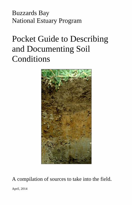
Cover illustration: © ISRIC, www.isric.org
The following sources were used in the compilation of this handbook: “Describing and Documenting Soil Conditions” US Department of Agriculture, Natural Resource Conservation Service, and the University of Massachusetts. “Describing and Documenting Soil Conditions” Department of Environmental Protection, 1993 “Geologic Deposits” Peter C. Fletcher Soil Survey Manual. USDA Handbook No. 18. Soil Survey Staff. 1993. www.nesoil.com James Turrene Acknowledgements: The BBNEP would like to thank Peter Fletcher and James Turenne for the use of their materials and years of soil advice. These materials were compiled by compiled by: John Rockwell Wetland Specialist Buzzards Bay National Estuary Program 2872 Cranberry Highway East Wareham, MA 02538 508-291-3625 x14 [email protected]
TABLE OF CONTENTS
Geologic Deposits
Glacial Till ……………………………………………..1 Shallow to Bedrock Areas ……………………………….2 Glacial Outwash …………………………………………2 Lakebed Sediments………………………………………3 Marine Silts ad Clays ……………………………………4 Organic Deposits ………………………………………..4 Coastal Dune Deposits ………………………………….5 Floodplain Deposits ……………………………………..5
Soil Profile Descriptions ………………………….6
Soil Horizon and Layer Designations ………………..6 O-Horizon ……………………………………….7 A-Horizon ………………………………………..7 E-Horizon ………………………………………..8 B-Horizon …………………………………………8 C-Layer ……………………………………………9 R-Layer ………………………………………….10
Distinctness …………………………………………10
Soil Texture & Field ID Soil Texture
Organic …………………………………………..11 Mucky Mineral …………………………………..11 Mineral Particle Soil Sizes ……………………….11
USDA Soil Texture Classes ……………………………13
Sands …………………………………………….14 Loamy Sands …………………………………….14 Sandy Loams ……………………………………15 Loams …………………………………………….15
Silt Loams ………………………………………..16 Silty Clay Loams ……………………………….16
Coarse Rock Fragments ………………………………..17 Textural Class Modifiers ………………………………17 Field Determination of Soil Texture……………………18
Soil Color
Soil Color ………………………………………19 Coloring Agents in the Soil …………………………..19 Munsell Color Book ………………………………….19 Soil Color Notation …………………………………..20 Recording Soil Color …………………………………20 Color Patterns in the Soil …………………………….21 (Martix Colors, Soil Mottling, Gleying Variegated
Colors, Redoximorphic Features) Potential Problem Areas when Interpreting Redoximorphic
Features ………………………………………21 Describing Redoximorphic Features …………………22
Soil Structure …………..………………………………..24 Soil Consistence ………………………….……………..25
1
Geologic Deposits There are eight broad groupings of unconsolidated geologic sediments (soil parent material) which occur within Massachusetts. Knowing the geology of a site is crucial to understanding how a site will impact adjacent areas and will help narrow the focus of an on-site investigation to key issues. Glacial Till Definition: Dominantly unsorted and unstratified debris deposited directly by a glacier; consisting of a heterogeneous mixture of clay, silt, sand. Gravel, stones, and boulders. Kinds: Two broad groupings of till: (1) Compact till (referred to as basal till or lodgement till) (2) Loose, sandy till (referred to as ablation till or meltout till)
Compact Till
Characteristics: (1) Wide particle size distribution: clay, silt, sand, gravel, cobbles,
stones and boulders (2) Unsorted, heterogeneous mixture (3) Angular shaped rock fragments (4) Substratum, firm and compact (locally referred to as hardpan) (5) Relatively high percent Clay (7 – 25%) (6) Rock fragments are held firmly in soil matrix Associated Landforms: (1) Drumlin (2) Till ridge (3) Ground moraine
Sandy. Loose Till (Ablation)
Characteristics: (1) Coarse textured, sandy, gravelly and stony (2) Typically loose, permeable material
2
(3) VARIABLE, often has lenses or pockets of silty material (4) Many stones and boulders (5) Small but significant amount of silt and clay Associated Landforms: (1) Moraines: terminal and recessional (2) Ground moraine
Shallow to Bedrock Areas Characteristics: (1) VARIABLE, complex soil conditions, typically pockets of deep
soil and areas of shallow to bedrock soils (2) Depth to bedrock often varies over short distances (3) Weathered or fractured bedrock can often be excavated easily but
is not considered suitable material for a leaching facility (4) Rippable or non-rippable with an excavator Associated Landforms: (1) Bedrock areas are not associated with any particular landforms (2) Typically bedrock areas are associated with irregular terrain, steep
ridges, abrupt KNOBS - however, some areas of bedrock are nearly level to gently rolling with few outcrops of ledge.
Glacial Outwash Definition: Stratified deposits of sands and gravel deposited by streams that flowed from melting glaciers. Kinds: Two broad groupings of outwash (1) Proglacial outwash - stratified outwash deposited in front of or just
beyond the outer limits of a glacier (2) Ice-contact outwash - sands and gravel originally deposited
adjacent to stagnant glacial ice, that collapsed when the ice melted, leaving an irregular, often hilly terrain
3
Proglacial Outwash
Characteristics: (1) Stratified, well sorted material. (2) Clean sands and gravel, typically with very little silt and clay (3) Generally lacks stones and boulders (4) Loose material, walls of pit slough in (5) If present, gravel and cobble size rock fragments are rounded
or sub-rounded
Associated Landforms: Outwash plain
Ice-Contact Outwash
Characteristics: (1) VARIABLE – conditions change over short distances. Very
difficult to predict (2) Collapsed or slumped bedding (3) Well sorted to poorly sorted debris (4) Typically loose, sandy material but may include pockets or
lenses of silty material (5) Dirty feel, often contains significant amounts of silt and clay (6) May include areas of stone and boulders Associated Landforms: (1) Kames (2) Kettles (3) Eskers (4) Kame deltas (5) Kame terraces
Lakebed (Lacustrine) Sediments Definition: well sorted, fine textured sediments deposited originally at the bottom of glacial lakes, which have since drained.
4
Characteristics: (1) Well sorted, fine textured sediments (2) Generally high content of silt and/or clay (3) Rock fragments of gravel size and larger are typically absent Associated Landforms: Typically an undulating to rolling terrain and may have steep graded escarpments adjacent to water courses. Marine Silts and Clays Definition: Areas of silts and clays deposited within a marine environment and have since been uplifted above present sea levels. Characteristics: (1) Limited extent, only occurring in the Boston area and north, and
only in those towns close to the coastline (2) VARIABLE - typically well sorted soils high in silts and clays (3) Locally referred to as blue clay Associated Landforms: Typically an undulating to rolling terrain, locally associated with land areas below certain elevations Organic Deposits Definition: Bog, swamp and marsh deposits comprised mostly of partially and well decomposed organic material. Characteristics: (1) Weak strength, spongy sensation when wallked across (2) Very dark color (3) Little to no mineral material (4) Formed in areas with a seasonal high water table at or near the
surface
5
Associated Landforms: Often within depressions and low lying areas adjacent to streams and lakes Coastal Dune Deposits Definition: A natural hill, mound or ridge of sediment landward of a coastal beach that was deposited by wind action or storm overwash. Characteristics: (1) Fine to coarse sands (2) Well sorted, often finely stratified (3) Little if no silt and clay, typically no gravel size or coarser rock
fragments (Note: Some exceptions to the lack of gravel and larger size particles occur in high energy areas.)
Associated Landforms: (1) Ridges that often parallel the shoreline landward of the beach (2) Hills or mounds (3) There are often unvegetated areas of loose sand Floodplain (Alluvial) Deposits Definition: Material transported and deposited by present day streams and rivers. Characteristics: (1) Susceptible to seasonal flooding (2) Nearly level areas adjacent to large streams and rivers (3) Well sorted, often stratified (4) Fine textured, but may vary depending upon the velocity of the
water (5) May have dark buried layers within the substratum that were at one
time surface layers Associated Landforms: (1) Floodplain (2) Stream terrace
6
(3) Oxbow (4) Meander scar Soil Profile Descriptions Soil Profile: A vertical section of the soil extending through all its horizons and into the parent material. Soil Horizon: A layer of soil, approximately parallel to the surface, having distinct characteristics produced by soil-forming processes. Soil Layer: A layer of soil deposited by geologic forces(e.g., wind, water, ice) and not relating to a soil forming process. Soil Horizon and Layer Designations Three kinds of symbols are used in various combinations to designate soil horizons and layers: capital letters, lowercase letters, and Arabic numerals. Master Horizons and Layers: O, A, E, B, C, and R are symbols that designate major breaks in the soil and are base symbols to which other characters may be added to describe the soil in more detail. Subordinate distinctions: Lower –case letters are used as suffixes to designate specific kinds of master horizons and layers ( e.g., Ap, Bw, Bs, Cd). Vertical subdivision: Two or more horizons or layers designated by a single combination of letters which need to be subdivided. Arabic numerals are used, and always follow all letters. Within a C layer, for example, successive C Layers should be designated as C1, C2, C3, etc.
7
O-Horizon Definition: O-Horizons are soil layers dominated by organic matter Field criteria: (1) Greater than 20-30% organic matter (less if high clay content). (2) Dark or dark-reddish brown, nearly black, color - colors can be
misleading and should only be used when other field criteria are observed.
(3) Low strength, greasy feel, light weight when dry, may have a high fiber content.
(4) Typically a very dark surface horizon. When observed buried beneath a mineral horizon, this may signify a disturbed site where the original soil was buried by fill material.
Subordinate distinctions of O-Horizons: Oa Highly decomplosed organic material; sapric Oe Organic material of intermediate decomposition; hemic Oi Slightly decomposed organic material; fibric A-Horizon Definition: A-Horizons are commonly referred to as the topsoil, and typically ranges from 3 to 10 inches in thickness. It is a mineral horizon that formed at the surface or below an O-horizon, and is characterized by an accumulation of humified organic matter intimately mixed with the mineral fraction. Field criteria: (1) Mineral soil material. (2) Mixture of well decomposed organic matter and mineral material. (3) Surface mineral horizon. (4) Typically dark in color – characteristically darker than underlying
horizons due to a relatively high organic content. Subordinate distinctions of A-Horizons: Ap Plowing or other disturbance. This symbol is used to indicate
disturbance of the surface layer by cultivation, pasturing, or similar uses.
8
E-Horizon Definition: E horizon: is a mineral horizon in the upper part of the soil, typically underlying an O or A-horizon. It is a light colored, leached horizon often associated with woodland areas. E-Horizons range from not being present in the soil to thicknesses of about 4 to 8 inches. Field criteria: (1) Commonly near the surface, underlying an O or A horizon and
above a B horizon. (2) Generally lighter in color than either the overlying organic and/or
A horizons and the underlying B horizon (E horizons MUST have a B horizon below).
Formation (in New England soils): (1) Upland soils - weak organic acids strip iron coating from the sand
grains and material is leached down into the subsoil. The light color of the E horizon is due to the natural color of the dominant quartz sand grains.
(2) Wet-Sandy soils - Tend to have rapidly fluctuating water tables. When the water is at or near the surface, iron is reduced and becomes soluble. When the water drops the iron precipitates out into the underlying B-horizon (organic material is often moved into the B horizon).
Subordinate distinctions of E-Horizons: Eg If the E horizon formed by saturation and reduction by a water
table, call it an Eg horizon to differentiate it from an upland E. Hydric Soil Concerns: E horizons (and Spodosols in general) may cause problems for hydric soil determination. The gray color of the E can be misinterpreted for a gleyed horizon. E horizons can occur in upland soils as well as hydric soils. Always look below the E for signs of wetness and see if the wetness morphology connects to the surface. B-Horizon Definition: B horizons are commonly referred to as the subsoil. They are a zone of accumulation where rain water percolating through the soil has leached material from above and it has precipitated within the B horizons
9
or the material may have weathered in place. Well drained soils typically have the brightest color development within the B horizons. Field criteria: (1) Subsurface horizon formed below an O, A and/or E horizon and
above the C layer. (2) In well drained soils, the B horizon is typically a yellowish brown
to strong brown color and is commonly referred to as the subsoil. (3) B - horizons have material (usually iron but also humus, clay,
carbonates, etc.) which has moved into it (Illuviation) they also have structure development in some pedons.
(4) Within New England, B horizons typically extend to a depth of 2 to 3 feet below the surface.
Subordinate distinctions of B-Horizons: Bg Strong gleying, indicating prolonged periods of saturation. Bhs or Bs Illuvial accumulation of sesquioxides and organic matter. Bm Cementation or induration, areas of bog iron in southeastern
Massachusetts would be identified with this symbol. Bw Development of color or structure. Because the soils in
Massachusetts are considered geologically young, this symbol is used frequently.
C-Layer Definition: C layers are commonly referred to as the substratum. These are layers, excluding bedrock, that are little affected by soil forming processes and have changed very little if any since the time they were deposited. C - horizons can have redoximorphic features within them. Field criteria: (1) Little affected by soil forming processes. (2) Lack color development, color is that of the unweathered geologic
material. (3) Geologic layering or strata is often present. (4) Most soil in the Northeast have a “cap” or mantle of eolian
material over the geologic C horizon, the 2C designation is used for soils with an eolian cap.
10
Subordinate distinctions of C-Layer: Cd Dense unconsolidated sediment; used to designate compact till Cg Strong gleying, indicating prolonged periods of saturation Cr Weathered or soft bedrock R-Layers Definition: Layers are hard bedrock Field Criteria: (1) Typically cannot be excavated using a backhoe unless fractured,
and blasting is often needed to remove this material. (2) When highly fractured and/or weathered, it is often difficult to
differentiate from the overlying soil material (3) May be difficult to differentiate between large boulders and depth
to bedrock. Distinctness. Distinctness refers to the thickness of the zone within which the boundary can be located. The distinctness of a boundary depends partly on the degree of contrast between the adjacent layers and partly on the thickness of the transitional zone between them. Distinctness is defined in terms of thickness of the transitional zone:
Abrupt: Less than 2 cm thick Clear: 2 to 5 cm thick Gradual: 5 to 15 cm thick Diffuse: More than 15 cm thick
Soil Texture Definition: The physical composition of soil defined in terms of the relative proportion by weight of the different particle size groups. Particle size and distribution are key factors in determining the rate of water movement through the soil.
11
Organic vs. Mineral Material Organic: 20 to 30 percent organic material by weight. Kinds of Organic Material
Fibric: Non- to slightly decomposed organic matter, greater than 2/3 fiber content.
Hemic: Partially decomposed organic matter, between 1/3 and 2/3 fiber content.
Sapric: Well decomposed organic matter, less than 1/3 fiber content. Field Test: Place a sample of wet soil material, roughly golf ball-sized
in the palm of your hand and squeeze. If the sample contains a high percentage of well decomposed organic matter, it will have a weak strength, and ooze through your fingers like smooth mashed potatoes. Mineral soil will not. Also, when dried, organic material is very light, whereas mineral material retains most of its weight. A dark soils indicates the presence of organic matter, but when used alone will not determine whether the soil in mineral or organic. dark in color.
Mucky Mineral: Material high in organic carbon could fall into three categories: organic, mucky mineral, or mineral.
Field Test: In lieu of laboratory data, the following estimation method can be used for soil material that is wet or nearly saturated with water. This method may be inconclusive with loamy or clayey textured mineral soils. Gently rub the wet soil material between forefinger and thumb. If upon the first or second rub the material feels gritty, it is mineral soil material. If after the second rub the material feels greasy, it is either mucky mineral or organic soil material. Gently rub the material two or three more times. If after these additional rubs it feels gritty or plastic, it is mucky mineral soil material; if it still feels greasy, it is organic soil material.
Mineral Soil Particle Sizes
Clay: < 0.002 mm Silt: 0.002 – 0.05 mm
12
Sand: 0.05 - 2.0 mm Gravel: 2.0 mm – 8 cm (3”) Cobble: 8 – 25 cm (3 – 10”) Stone: 25 – 60 cm (10 – 24”) Boulder: > 60 cm (24”)
Soil color has no bearing on soil texture. Gray colors do not imply a clayey material. Sand Size Particles Size Classes
very coarse sand: 2.0 – 1.0 mm coarse sand: 1.0 – 0.5 mm medium sand: 0.5 – 0.25 mm fine sand: 0.25 – 0.10 mm very fine sand: 0.10 – 0.05 mm
Feel
Sand Size Dry Moist Loose Loose Very fine Slightly gritty Slightly gritty Fine to coarse Very Gritty Very Gritty
Particle seen with naked eye; hands easily wiped clean with little or no material remaining in pores. Silt Size Particles Silt size: 0.05 -0.002 mm
Feel Dry Wet Firm, but can be crushed between fingers; when pulverized, soft & floury; no grittiness when rubbed
Smooth; no gritty feel; non-plastic; non-sticky
13
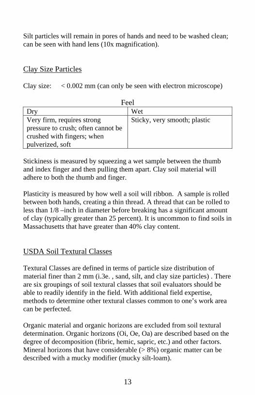
Silt particles will remain in pores of hands and need to be washed clean; can be seen with hand lens (10x magnification). Clay Size Particles Clay size: < 0.002 mm (can only be seen with electron microscope)
Feel Dry Wet Very firm, requires strong pressure to crush; often cannot be crushed with fingers; when pulverized, soft
Sticky, very smooth; plastic
Stickiness is measured by squeezing a wet sample between the thumb and index finger and then pulling them apart. Clay soil material will adhere to both the thumb and finger.
Plasticity is measured by how well a soil will ribbon. A sample is rolled between both hands, creating a thin thread. A thread that can be rolled to less than 1/8 –inch in diameter before breaking has a significant amount of clay (typically greater than 25 percent). It is uncommon to find soils in Massachusetts that have greater than 40% clay content. USDA Soil Textural Classes Textural Classes are defined in terms of particle size distribution of material finer than 2 mm (i.3e. , sand, silt, and clay size particles) . There are six groupings of soil textural classes that soil evaluators should be able to readily identify in the field. With additional field expertise, methods to determine other textural classes common to one’s work area can be perfected. Organic material and organic horizons are excluded from soil textural determination. Organic horizons (Oi, Oe, Oa) are described based on the degree of decomposition (fibric, hemic, sapric, etc.) and other factors. Mineral horizons that have considerable (> 8%) organic matter can be described with a mucky modifier (mucky silt-loam).
14
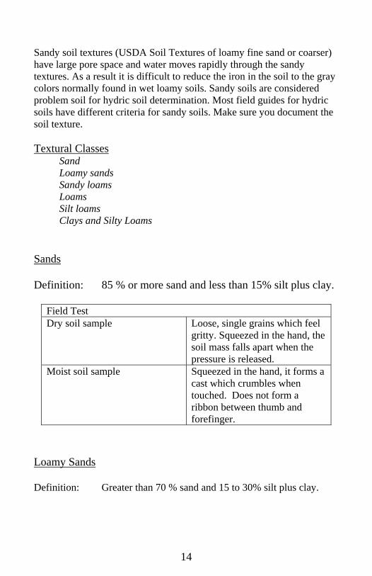
Sandy soil textures (USDA Soil Textures of loamy fine sand or coarser) have large pore space and water moves rapidly through the sandy textures. As a result it is difficult to reduce the iron in the soil to the gray colors normally found in wet loamy soils. Sandy soils are considered problem soil for hydric soil determination. Most field guides for hydric soils have different criteria for sandy soils. Make sure you document the soil texture. Textural Classes Sand Loamy sands Sandy loams
Loams Silt loams Clays and Silty Loams Sands Definition: 85 % or more sand and less than 15% silt plus clay.
Field Test Dry soil sample
Loose, single grains which feel gritty. Squeezed in the hand, the soil mass falls apart when the pressure is released.
Moist soil sample Squeezed in the hand, it forms a cast which crumbles when touched. Does not form a ribbon between thumb and forefinger.
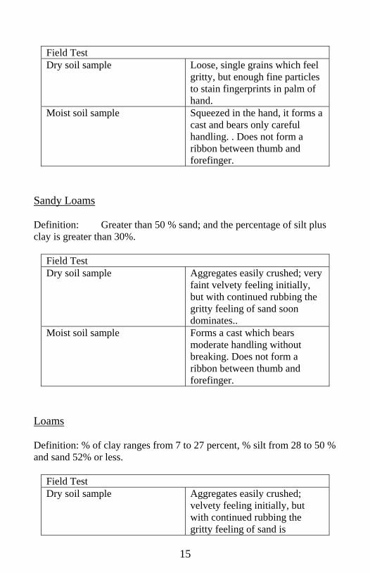
Loamy Sands Definition: Greater than 70 % sand and 15 to 30% silt plus clay.
15
Field Test Dry soil sample
Loose, single grains which feel gritty, but enough fine particles to stain fingerprints in palm of hand.
Moist soil sample Squeezed in the hand, it forms a cast and bears only careful handling. . Does not form a ribbon between thumb and forefinger.
Sandy Loams Definition: Greater than 50 % sand; and the percentage of silt plus clay is greater than 30%.
Field Test Dry soil sample
Aggregates easily crushed; very faint velvety feeling initially, but with continued rubbing the gritty feeling of sand soon dominates..
Moist soil sample Forms a cast which bears moderate handling without breaking. Does not form a ribbon between thumb and forefinger.
Loams Definition: % of clay ranges from 7 to 27 percent, % silt from 28 to 50 % and sand 52% or less.
Field Test Dry soil sample
Aggregates easily crushed; velvety feeling initially, but with continued rubbing the gritty feeling of sand is
16
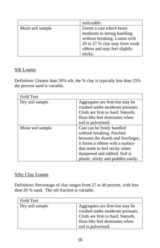
noticeable. Moist soil sample Forms a cast which bears
moderate to strong handling without breaking. Loams with 20 to 27 % clay may form weak ribbon and may feel slightly sticky.
Silt Loams Definition: Greater than 50% silt, the % clay is typically less than 25% the percent sand is variable.
Field Test Dry soil sample
Aggregates are firm but may be crushed under moderate pressure. Clods are firm to hard. Smooth, flour-like feel dominates when soil is pulverized.
Moist soil sample Cast can be freely handled without breaking. Pinched between the thumb and forefinger, it forms a ribbon with a surface that tends to feel sticky when dampened and rubbed. Soil is plastic, sticky and puddles easily.
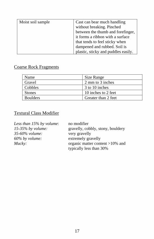
Silty Clay Loams Definition: Percentage of clay ranges from 27 to 40 percent, with less than 20 % sand. The silt fraction is variable.
Field Test Dry soil sample
Aggregates are firm but may be crushed under moderate pressure. Clods are firm to hard. Smooth, flour-like feel dominates when soil is pulverized.
17
Moist soil sample Cast can bear much handling without breaking. Pinched between the thumb and forefinger, it forms a ribbon with a surface that tends to feel sticky when dampened and rubbed. Soil is plastic, sticky and puddles easily.
Coarse Rock Fragments
Name Size Range Gravel 2 mm to 3 inches Cobbles 3 to 10 inches Stones 10 inches to 2 feet Boulders Greater than 2 feet
Textural Class Modifier Less than 15% by volume: no modifier 15-35% by volume: gravelly, cobbly, stony, bouldery 35-60% volume: very gravelly 60% by volume: extremely gravelly Mucky: organic matter content >10% and
typically less than 30%
18
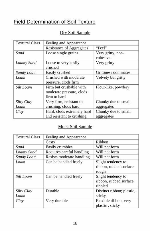
Field Determination of Soil Texture
Dry Soil Sample
Textural Class Feeling and Appearance Resistance of Aggregates “Feel”
Sand Loose single grains Very gritty, non-cohesive
Loamy Sand Loose to very easily crushed
Very gritty
Sandy Loam Easily crushed Grittiness dominates Loam Crushed with moderate
pressure, clods firm Velvety but gritty
Silt Loam Firm but crushable with moderate pressure, clods firm to hard
Flour-like, powdery
Silty Clay Loam
Very firm, resistant to crushing, clods hard
Chunky due to small aggregates
Clay Hard, clods extremely hard and resistant to crushing
Chunky due to small aggregates
Moist Soil Sample
Textural Class Feeling and Appearance
Casts Ribbon Sand Easily crumbles Will not form Loamy Sand Requires careful handling Will not form Sandy Loam Resists moderate handling Will not form Loam Can be handled freely Slight tendency to
ribbon, rubbed surface rough
Silt Loam Can be handled freely Slight tendency to ribbon, rubbed surface rippled
Silty Clay Loam
Durable Distinct ribbon; plastic, sticky
Clay Very durable Flexible ribbon; very plastic , sticky
19
Soil Color Soil Color Soil color is the most obvious and easily determined soil characteristic. Although it has little known direct influence on the functioning of the soil, color is one of the most easily determined soil properties. Other more important soil characteristics can be inferred from soil color.
Well drained soils have bright colors in the subsoil
Soils with a fluctuating water table have a blotchy color pattern of gray yellow and orange.
Coloring Agents in the Soil Organic matter darkens the soil and is typically associated with the surface layers. Organic matter will mask all other coloring agents. Buried organic layers generally indicate disturbed soil areas. Iron is the primary coloring agent in the subsoil. Iron minerals are nearly universal in all New England soils. The bright orange brown color associated with well drained soils is the result of iron oxide stains coating individual soil particles. Manganese is common in some New England soils and is very dark black or purplish–black color. Note: In the absence of color coatings, soils are the color of the mineral grains. Munsell Color Book Soil colors are most conveniently measured by comparison with a color chart. The Munsell color chart consists of some 245 different colored chips, systematically arranged according to their Munsell notations. Hue: Refers to the dominant spectral wavelength of light (red,
yellow, green, blue, etc.) . The symbol for hue is the letter abbreviation of the color preceded by a number from 0 to 10.
20
With the YR (yellow-red) range, the hue becomes more yellow and less red as the number increases. The notation for hue in the Munsell Color Book is located at the top corner of the chart page. One hue is represented on each page.
Value: Refers to the lightness and darkness of a color in relation to
neutral gray scale. The notation for value consists of numbers from 0 (black) to 10 (white). In the Munsell Color Book, value is located along the vertical scale to the left of the page.
Chroma: Is the relative purity or strength of the color (hue). The
notation for chroma consists of numbers beginning at 0 for neutral grays and increasing at equal intervals to 8 (bright colors).
Soil Color Notation Once a determination of soil color is made, the proper notation of the color is the hue (e.g., 10YR) followed by the value/chroma. Value is always written first, followed by chroma. An example of the correct notation of a soil color would be 10YR 5/6 (value of 5, chroma of 6). Recording Soil Color
Three conditions may be encountered when examining soil colors; wet, moist, or dry. Moist soil colors are recorded for deep observation soil logs and for wetland delineations. Note: There is a natural variability between evaluators, as people’s perceptions of color vary. It is not unusual for color readings to vary one color chip in any direction. Light Conditions: Soil colors are recorded outdoors in direct sunlight, typically sunlight coming from over the shoulder. When the sun is at a low angle, colors become difficult to read. Note: Always remove sunglasses. Locations in Soil: Colors are typically recorded from the surface of a freshly broken clod of soil.
21
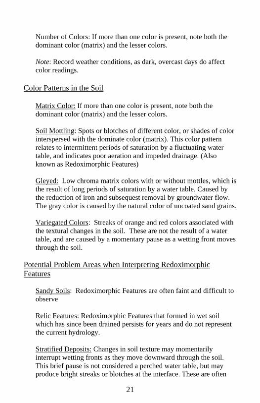
Number of Colors: If more than one color is present, note both the dominant color (matrix) and the lesser colors. Note: Record weather conditions, as dark, overcast days do affect color readings.
Color Patterns in the Soil
Matrix Color: If more than one color is present, note both the dominant color (matrix) and the lesser colors. Soil Mottling: Spots or blotches of different color, or shades of color interspersed with the dominate color (matrix). This color pattern relates to intermittent periods of saturation by a fluctuating water table, and indicates poor aeration and impeded drainage. (Also known as Redoximorphic Features) Gleyed: Low chroma matrix colors with or without mottles, which is the result of long periods of saturation by a water table. Caused by the reduction of iron and subsequest removal by groundwater flow. The gray color is caused by the natural color of uncoated sand grains. Variegated Colors: Streaks of orange and red colors associated with the textural changes in the soil. These are not the result of a water table, and are caused by a momentary pause as a wetting front moves through the soil.
Potential Problem Areas when Interpreting Redoximorphic Features
Sandy Soils: Redoximorphic Features are often faint and difficult to observe Relic Features: Redoximorphic Features that formed in wet soil which has since been drained persists for years and do not represent the current hydrology. Stratified Deposits: Changes in soil texture may momentarily interrupt wetting fronts as they move downward through the soil. This brief pause is not considered a perched water table, but may produce bright streaks or blotches at the interface. These are often
22
seen within gravel pits, high above the water table, and are referred to as variegated colors. Parent Material: Some soils have developed in dark sediments with dark mineralogy, and may mask redoximorphic feature development. Soil Chemistry: Some soils have unique chemical properties that inhibit the development of redoximorphic features. Soil developed thin Triassic Red Sandstone sediments and soils that are immediately adjacent to brackish water are examples of soils which do not display easily recognizable redox features.
Describing Redoximorphic Features A description of Redoximorphic Features requires notation of the colors and the color pattern(s). Colors may be noted by Munsell symbols for the matrix and redox features. Color pattern may be described with the following terms: Abundance:
Few: redox features < 2% of surface f Common: redox features 2 - 20% of surface c Many: redox features > 20% of surface m
Size:
Fine: < 5 mm 1 Medium: 5 – 15 mm 2 Coarse: > 15 mm 3
Contrast: Faint: Hue and chroma of matrix and redox
features closely related f Distinct: Matrix and redox features vary 1- 2
hues and several units in chroma and value d
Prominent: Matrix and redox features vary several units in hue, value, and chroma p

23
24
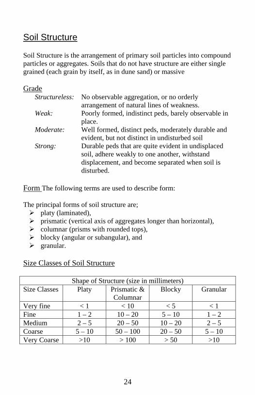
Soil Structure
Soil Structure is the arrangement of primary soil particles into compound particles or aggregates. Soils that do not have structure are either single grained (each grain by itself, as in dune sand) or massive Grade
Structureless: No observable aggregation, or no orderly arrangement of natural lines of weakness.
Weak: Poorly formed, indistinct peds, barely observable in place.
Moderate: Well formed, distinct peds, moderately durable and evident, but not distinct in undisturbed soil
Strong: Durable peds that are quite evident in undisplaced soil, adhere weakly to one another, withstand displacement, and become separated when soil is disturbed.
Form The following terms are used to describe form: The principal forms of soil structure are;
platy (laminated), prismatic (vertical axis of aggregates longer than horizontal), columnar (prisms with rounded tops), blocky (angular or subangular), and granular.
Size Classes of Soil Structure
Shape of Structure (size in millimeters) Size Classes Platy Prismatic &
Columnar Blocky Granular
Very fine < 1 < 10 < 5 < 1 Fine 1 – 2 10 – 20 5 – 10 1 – 2 Medium 2 – 5 20 – 50 10 – 20 2 – 5 Coarse 5 – 10 50 – 100 20 – 50 5 – 10 Very Coarse >10 > 100 > 50 >10
25
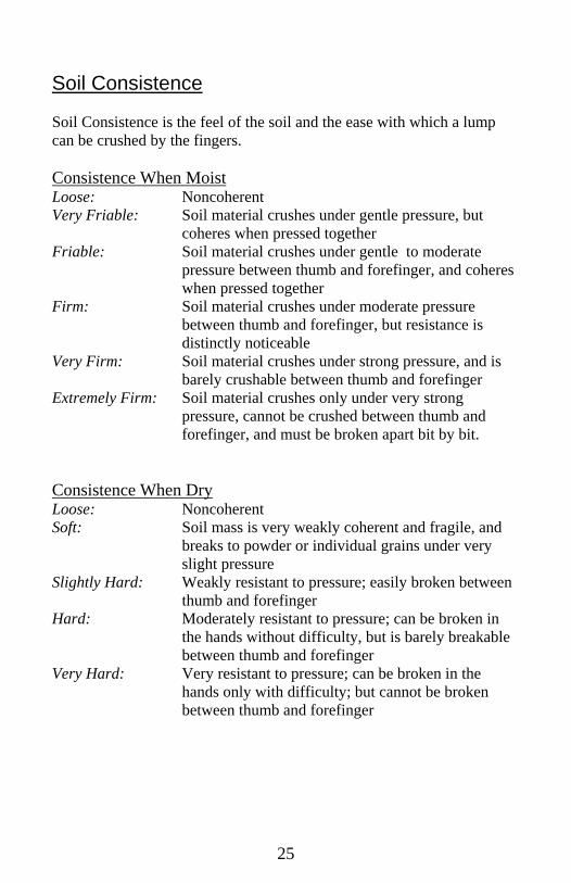
Soil Consistence Soil Consistence is the feel of the soil and the ease with which a lump can be crushed by the fingers. Consistence When Moist Loose: Noncoherent Very Friable: Soil material crushes under gentle pressure, but
coheres when pressed together Friable: Soil material crushes under gentle to moderate
pressure between thumb and forefinger, and coheres when pressed together
Firm: Soil material crushes under moderate pressure between thumb and forefinger, but resistance is distinctly noticeable
Very Firm: Soil material crushes under strong pressure, and is barely crushable between thumb and forefinger
Extremely Firm: Soil material crushes only under very strong pressure, cannot be crushed between thumb and forefinger, and must be broken apart bit by bit.
Consistence When Dry Loose: Noncoherent Soft: Soil mass is very weakly coherent and fragile, and
breaks to powder or individual grains under very slight pressure
Slightly Hard: Weakly resistant to pressure; easily broken between thumb and forefinger
Hard: Moderately resistant to pressure; can be broken in the hands without difficulty, but is barely breakable between thumb and forefinger
Very Hard: Very resistant to pressure; can be broken in the hands only with difficulty; but cannot be broken between thumb and forefinger