Embed Size (px)
Citation preview
Policy Direction Highlights - Booklet 1
Shaping land use, scale & economy A land use framework that promotes a balanced approach to growth will be of paramount importance in the Downtown Secondary Plan. Achieving this requires the adoption of land use designations that provide more detailed guidance to the direction of growth. It also requires achieving a balance between residential uses and other important drivers of the economy – office, institutions, retail and cultural industries.
www.toronto.ca/tocore
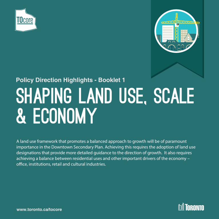
Directing Growth
The Official Plan identifies that growth is to be directed to certain areas of the city, and the Downtown is one of those areas expected to absorb growth. The Official Plan also identifies that not all areas within the Downtown will experience the same level or intensity of growth. A Downtown Structure Map will identify the areas within Downtown that will experience the greater levels of future growth in jobs and residents.
Stable Neighbourhoods and Apartment Neighbourhoods
The Neighbourhoods and Apartment Neighbourhoods policies have recently been updated in the Official Plan. Given these recent revisions through Official Plan Amendment 320 no Downtown-specific amendments to the Neighbourhoods and Apartment Neighbourhoods policies are anticipated.
A Finer-Grain of Mixed Use
b1
Downtown contains a large concentration of Mixed Use Areas, encompassing the Financial District, the Yonge/University subway corridor, and the main east-west and north-south arterial roads, such as Queen Street, Dundas Street, Bloor Street, Church Street, and Jarvis Street. The variety of uses found Downtown combined with the fine grain lot pattern has resulted in wide-ranging intensity of development throughout. Each of the areas designated as Mixed Use Areas has varied characteristics and constraints, and thus, the anticipated scale and intensity of growth and the scale of development varies and should be based on a respect for the local context.
To address the diversity of the Mixed Use Areas Downtown and to reflect that tall buildings are but one form of development, staff are proposing to create three (3) sub-categories within the Mixed Use Areas designations along with associated land use policies, within the Downtown Secondary Plan.
b Policy Directions
B1: Establish three (3) sub-categories in the Mixed Use Areas designation as described on the proposed Mixed Use Areas Map.
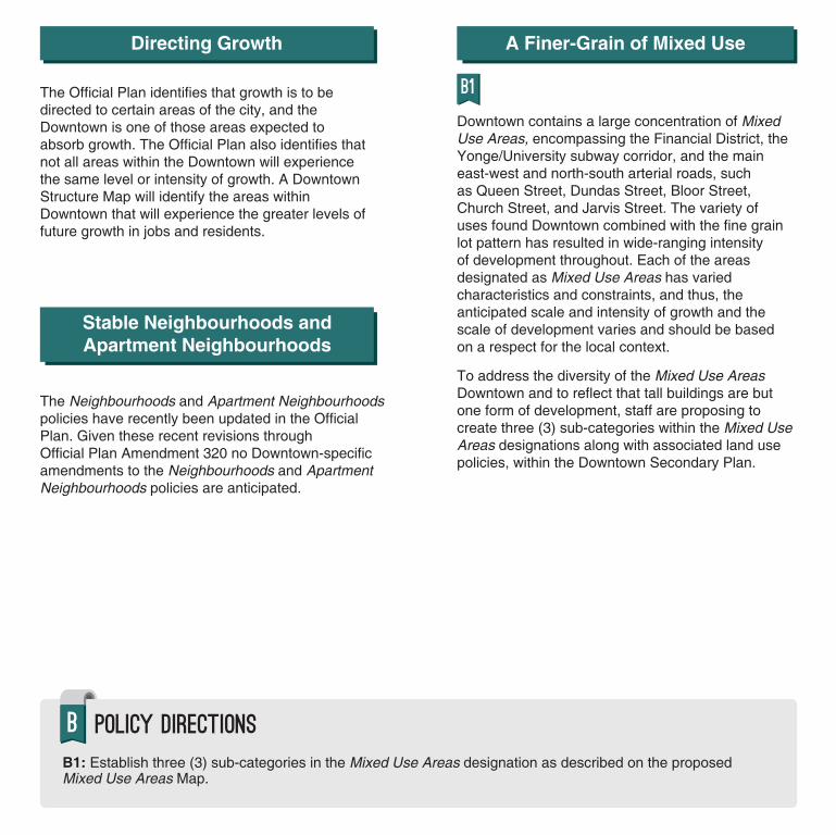
Proposed Mixed Use Areas
Proposed Mixed Use Areas
These Mixed Use Areas have a "mainstreet" characterThey may contain a large number of heritage buildings, house form buildings, midrise buildings, and are immediately adjacent to Neigbourhoods. Modestintensification is anticipated in this designation
TOcore Study Area
Mixed Use Area 3 Mixed Use Area Outsideof the TOcore Study Area
These Mixed Use Areas are the transition areas between the low density areas and the higher density areas. Intensification is anticipated in this designation.
Mixed Use Area 2These Mixed Use Areas are generally along theYonge Street / Bay Street / University Avenue Corridors,along subway lines, and master planned communities.Tall buildings are one of the many building typologies anticipated. Intensification is anticipated in this designation.
Mixed Use Area 1
Chur
ch
Grac
e St
Wellesley
Front
Front
Bay
Queens Quay
Wellington
Univ
ersi
ty
Shuter
Cherry
Commissioners
Bedf
ord
Yong
e
Rosedale Valley
King
Broa
dview
Bayv
iew
Do
n V
alle
y P
arkw
ay
Richmond Adelaide
GardinerGardiner GardinerGardiner
Mou
nt P
leas
ant
Don River
C N R
C N R
C P
R
Dupont
Bath
urst
St
Bloor
Harbord Hoskin
College Carlton
Dundas
Queen
Spad
ina
St G
eorg
eJo
hn
York
Jarv
is
Sher
bour
ne
Broa
dvie
w
C P R
Aven
ue
Belmont
Gerrard
Parli
amen
t
Rive
r
C P R C N R C N R
Toronto Inner Harbour
TOcore Study Area
Mixed Use Area Outside of the TOcore Study Area
Mixed Use Area 1 These Mixed Use Areas are generally along the Yonge Street / Bay Street / University Avenue Corridors, along subway lines, and master planned communities. Tall buildings are one of the many building typologies anticipated. Intensification is anticipated in this designation.
Mixed Use Area 2 These Mixed Use Areas are the transition areas between the low density areas and the higher density areas. Intensification is anticipated inthis designation.
Mixed Use Area 3 These Mixed Use Areas have a "mainstreet" character. They may contain a large number of heritage buildings, house form buildings, midrise buildings, and are immediately adjacent to Neigbourhoods. Modest intensification is anticipated in this designation.
Chur
ch
Prioritize Non-Residential Uses
b3 b4 b6 b8 b9
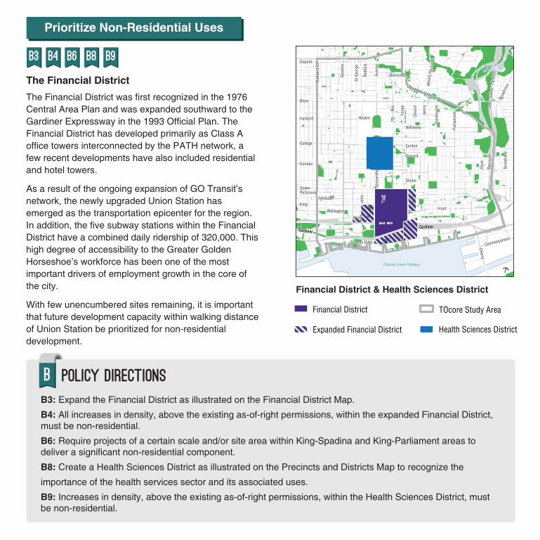
The Financial District The Financial District was first recognized in the 1976 Central Area Plan and was expanded southward to the Gardiner Expressway in the 1993 Official Plan. The Financial District has developed primarily as Class A office towers interconnected by the PATH network, a few recent developments have also included residential and hotel towers.
As a result of the ongoing expansion of GO Transit’s network, the newly upgraded Union Station has emerged as the transportation epicenter for the region. In addition, the five subway stations within the Financial District have a combined daily ridership of 320,000. This high degree of accessibility to the Greater Golden Horseshoe’s workforce has been one of the most important drivers of employment growth in the core of the city.
With few unencumbered sites remaining, it is important that future development capacity within walking distance of Union Station be prioritized for non-residential development.
Financial District & Health Sciences District
TOcore Study AreaFinancial District
Expanded Financial District
Grac
e St
Health Sciences District
Wellesley
Front
Front
Bay
Queens Quay
Carlton
Dupont
Wellington
Univ
ersi
ty
Shuter
Cherry
Commissioners
Bedf
ord
Yong
e
Rosedale Valley
King
Broa
dview
Bayv
iew
Do
n V
alle
y P
arkw
ay
Richmond Adelaide
GardinerGardiner GardinerGardiner
Mou
ntPl
easa
nt
Don River
C N R
C N R
C P
R
Bloor
Harbord
College
Dundas
Queen
C P R
Bath
urst
St
Spad
ina
Hoskin
C P R
St G
eorg
e
John
York
Aven
ue
Toronto Inner Harbour
Chur
ch
Gerrard
C N R
Jarv
is
Sher
bour
ne
Belmont
Parli
amen
t
Rive
r
C N R
Broa
dvie
w
Financial District & Health Sciences District
Financial District TOcore Study Area
Expanded Financial District Health Sciences District
b Policy Directions
B3: Expand the Financial District as illustrated on the Financial District Map. B4: All increases in density, above the existing as-of-right permissions, within the expanded Financial District, must be non-residential. B6: Require projects of a certain scale and/or site area within King-Spadina and King-Parliament areas to deliver a significant non-residential component. B8: Create a Health Sciences District as illustrated on the Precincts and Districts Map to recognize the
importance of the health services sector and its associated uses. B9: Increases in density, above the existing as-of-right permissions, within the Health Sciences District, must be non-residential.

Prioritize Non-Residential Uses
b15
Health Sciences District
A significant number of treatment, education, research and related commercial functions are clustered within close walking distance of each other in an area centred on University Avenue.
The increasing residential population Downtown has resulted in greater demands for local medical services. These pressures have challenged the efficiency and functionality of hospitals within Downtown which have historically played a highly-specialized medical role. Over the past few decades many of the hospitals have expanded their physical plants not just for medical offices and patient care, but for education and research. In order to meet both increased local demands resulting from a growing population, while continuing to provide specialized services, it is anticipated that additional hospital expansions will be required. To ensure there is a continuing capacity to meet future demands for medical services, existing hospitals require the ability to expand on-site or into immediately adjacent parcels.
Post Secondary Institutions The university and college campuses Downtown have a regional role and serve an important function in the core of the city. The four major institutions (University of Toronto, Ryerson University, OCAD University, and George Brown College) accommodate a combined enrollment of 135,000 students and thousands of associated jobs.
The lands associated with post-secondary institutions encompass a variety of land use designations. Although some sites are designated Institutional Areas, others are more permissive Mixed Use Areas or Regeneration Areas.
Encouraging Expansion of Office Development in King-Parliament & King-Spadina
The proximity of the King-Spadina neighbourhood to the Financial District, and its unique stock of brick and beam buildings, have made it the centre of the creative and cultural industry boom in the city.
Approximately 45,000 office workers are employed in King-Spadina. The increasing scale and intensity of residential developments has raised concerns that some businesses and cultural organizations are at risk of being displaced.
King-Parliament is also experiencing an increasing number of development applications, but has not yet reached the same intensity as King-Spadina. New office developments in King-Parliament indicate market support for new non-residential construction. Once completed, these buildings will add to the existing 15,000 office workers located in this area.
b Policy Directions
B15: To encourage the continued health and vibrancy of the Downtown, lands used by post-secondary institutions may be redesignated to Institutional Areas.
Encouraging Flexible & Diverse Retail
b16 b17 b18 b19 b20
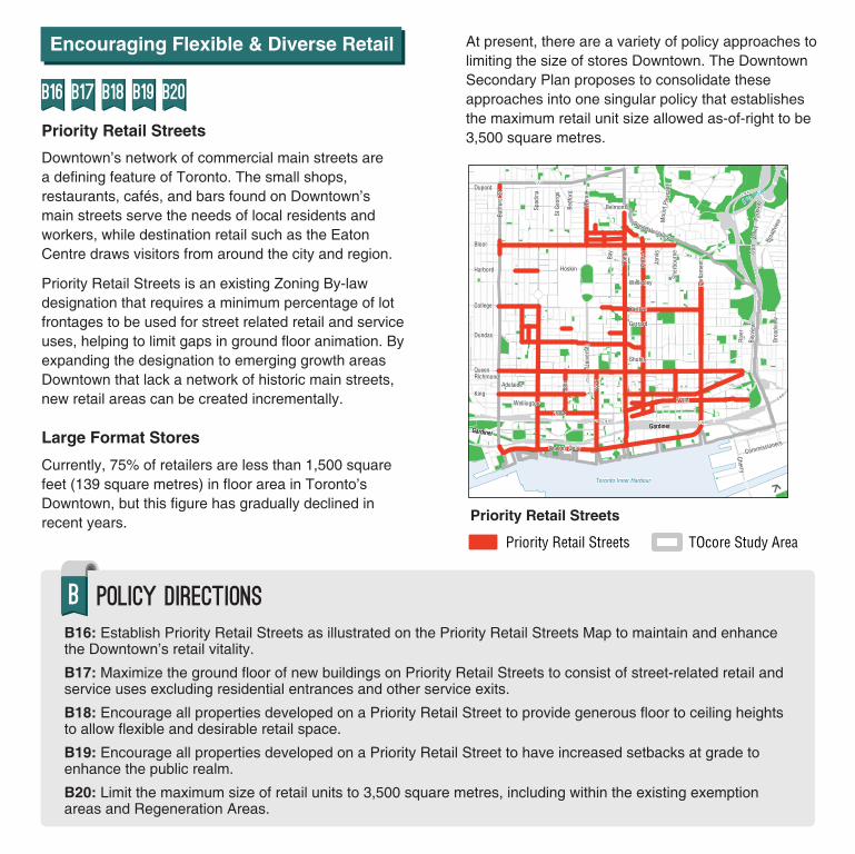
Priority Retail Streets Downtown’s network of commercial main streets are a defining feature of Toronto. The small shops, restaurants, cafés, and bars found on Downtown’s main streets serve the needs of local residents and workers, while destination retail such as the Eaton Centre draws visitors from around the city and region.
Priority Retail Streets is an existing Zoning By-law designation that requires a minimum percentage of lot frontages to be used for street related retail and service uses, helping to limit gaps in ground floor animation. By expanding the designation to emerging growth areas Downtown that lack a network of historic main streets, new retail areas can be created incrementally.
Large Format Stores
Currently, 75% of retailers are less than 1,500 square feet (139 square metres) in floor area in Toronto’s Downtown, but this figure has gradually declined in recent years.
At present, there are a variety of policy approaches to limiting the size of stores Downtown. The Downtown Secondary Plan proposes to consolidate these approaches into one singular policy that establishes the maximum retail unit size allowed as-of-right to be 3,500 square metres.
Priority Retail Streets
Priority Retail Streets
TOcore Study Area
Chris
tie S
tGr
ace
StLake Shore Blvd W
Wellesley
Front
Front
Bay
Queens Quay
Wellington
Univ
ersi
ty
Shuter
Cherry
Commissioners
Bedf
ord
Yong
e
Rosedale Valley
King
Broa
dview
Bayv
iew
Do
n V
alle
y P
arkw
ay
Richmond Adelaide
GardinerGardiner GardinerGardiner
Mou
ntPl
easa
nt
Don River
C N R
C N R
C P
R
C P R
Bloor
Harbord Hoskin
College Carlton
Gerrard
Dundas
Queen
Toronto Inner Harbour
Spad
ina
St G
eorg
eJo
hn
York
Chur
ch
Jarv
is
Sher
bour
ne
Broa
dvie
w
Dupont
Bath
urst
St
Aven
ue
Belmont
Parli
amen
t
Rive
r
C P R C N R C N R
Priority Retail Streets
Priority Retail Streets TOcore Study Area
b Policy Directions
B16: Establish Priority Retail Streets as illustrated on the Priority Retail Streets Map to maintain and enhancethe Downtown’s retail vitality.
B17: Maximize the ground floor of new buildings on Priority Retail Streets to consist of street-related retail and service uses excluding residential entrances and other service exits.
B18: Encourage all properties developed on a Priority Retail Street to provide generous floor to ceiling heights to allow flexible and desirable retail space.
B19: Encourage all properties developed on a Priority Retail Street to have increased setbacks at grade to enhance the public realm.
B20: Limit the maximum size of retail units to 3,500 square metres, including within the existing exemption areas and Regeneration Areas.

Have you met our Avatars?
Jerome
33 years old | Young professional Rents with a roommate | Walks to work
"By officially designating the area around hospital row as a Health Sciences District, hospitals will be able to expand to better serve Downtown's growing population, and create new job opportunities for people like me."
Fred
75 years old | Retired | Downtown | Aging at home
"Limiting the size of retail stores Downtown will support local businesses and keep our neighbourhoods vibrant."
Tell us about yourself
How will these policies improve the quality of your life?
Draw yourself in!You

Have Your Say
• How do you think these policies will improve Downtown?• What policies would you change? How?• Is anything missing?
This booklet provides you with an overview of the Policy Directions in the TOcore Proposals
Report. To see them all please visit
www.toronto.ca/tocore