Embed Size (px)
Citation preview
POST-CONSTRUCTION WILDLIFE MONITORING AT THE ATLANTIC CITY UTILITIES AUTHORITY-
JERSEY ATLANTIC WIND POWER FACILITY
PERIODIC REPORT COVERING WORK CONDUCTED BETWEEN 20 JULY AND 31 DECEMBER 2007
Submitted to:
New Jersey Board of Public UtilitiesNew Jersey Clean Energy ProgramTwo Gateway Center (8th Floor)
Newark, NJ 07102
Submitted by:
New Jersey Audubon SocietyCenter for Research and Education
600 Route 47 NorthCape May Court House, NJ 08210
18 February 2008
2
INTRODUCTIONThe following narrative briefly describes activities New Jersey Audubon Society (NJAS)engaged in during a post-construction wildlife monitoring study conducted from 20 July - 31December 2007 at the Jersey Atlantic Wind, LLC (JAW)/Atlantic City Utilities Authority(ACUA) wind power facility. This document and attachments satisfies project reportingrequirements described in the Memorandum of Understanding (MOU) between NJAS and JAW. Furthermore, the activities described herein conform to task descriptions outlined in the Scope ofWork defined as part of said MOU.
GOALS AND OBJECTIVESThe goal of this project is to evaluate incidents of bird and bat mortality at JAW/ACUA windwind power facility and assess relationships between mortality and flight dynamics (e.g.,magnitude, altitude, direction). Specifically, our objectives are to (1) document mortality at thefacility, (2) quantify nightly magnitude of bird/bat passage through the project area (3) quantifyaltitudes and flight tracks relative to the height and rotor swept area of the wind turbines (4)investigate correlations between mortality and flight dynamics and (5) investigate meteorologicalconditions that may affect these response variables. To accomplish these objectives we will useground based surveys to monitor mortality at the project sites and a dual marine radar system tomonitor the various measures of flight behavior. This two-pronged approach is rarely used inevaluating potential impacts of wind turbines on birds and bats.
METHODSNocturnal Flight Monitoring using RadarWe used two 25 kW Furuno X-band marine radars (frequency = 9410 GHz, wavelength = 3 cm,model # FAR2127BB, Furuno Electric Company, Nishinomiya, Japan) operating simultaneouslyto monitor various measures of flight behavior and dynamics (Figure 1). Each radar is fittedwith standard 6.5' open array antenna, which produces a fan-shaped electromagnetic beam 1.23/x 20/. The radars' pulse lengths can be set from 0.07 - 1.2 µsec and detection ranges from 0.125- 96 nautical miles (nm). For both radars we used a 0.15 µsec pulse length and a 1.0 nmdetection range. Short pulse lengths provide better target resolution and more accurate locationand distance estimates. Similarly, short detection ranges result in improved resolution of smallpasserine or bat-sized targets. Additionally, data we collected during previous studies suggestthat small target detection drops off markedly between 0.75 and 1.0 nm from the radar. Theradar features color-coded target representation that indicates return signal strength. This allowsfor discrimination of weak reflectors that could be insects. The radar units also are equippedwith integrated global positioning systems (GPS) and target tracking feature that allows us todetermine each target's coordinates and quantify target flight directions.
One radar unit operated with the antenna rotating in the horizontal plane, describing a 360/ arcevery 2.5 seconds. Data collected in this mode provided target density (i.e., targets/unit volume)and passage rate (targets/km/hr) estimates (Figure 2). The second radar's antenna rotated in thevertical plane. This is accomplished by mounting the antenna turning unit perpendicular to theground (Figure 1). In this mode, the radar monitors the altitudinal distribution of targets andpassage density/rates. The antenna sweeps from the eastern to the western horizons, describing a
3
180/ arc above radar level (arl), 20o wide (Figure 3). To avoid spurious target propagation, theradar does not transmit when the antenna is pointing toward the ground. We anticipated that theradar's orientation (i.e., facing northward, antenna sweeping approximately east to west) wouldmaximize the number of target detections along the predominantly north/south axis of birdmigration.
Each radar's processor unit was connected directly to a computer equipped with a PCI framegrabber circuit board. Using proprietary scheduling software, we automatically captured a user-defined number of consecutive radar sweep images as bitmap files at any interval and for anyperiod.
Radar data collection typically followed a "five days on," "two days off" sampling protocol. Wecollected five consecutive radar sweep images, every 10 min, continuously for five consecutivedays (~720 images/night/radar). We chose 10 min intervals because we believe this insures totalturnover of targets between samples. If minimum target air speed is 20 mph, then it will take 6min to cross the widest part of our sample area (i.e., two nautical miles).
Collision Incident MonitoringWe conducted systematic searches on the ACUA facility for birds and bats that apparentlycollided with on-site wind turbines. Searches were conducted around each turbine site (Figure 4)by a single, trained NJAS staff person and consisted of walking in parallel transects 5 m apartwithin an overall search area of 130 m x 120 m (i.e., 15,600 m2/turbine) centered on each turbinetower (Figure 5). Search areas and transects were laid out in a geographic information system(GIS) and marked on site using a global positioning system (GPS) and rangefinder. Low lyingmarsh areas within a turbine's search area were not surveyed because tidal inundation regularlyprevented access to these sections (Figure 6). To some extent this was the case at all turbinesites except at turbine #3 (Figure 6). If a building fell within the search area, rooftops weresurveyed when accessible. Clarifying and mixing ponds, and other water bodies were alsosurveyed using walkways, gangways and dikes to gain access. Collision incident estimates willbe corrected for the proportion of the total area around each turbine that was searched.
Searches were conducted at each turbine sampling plot every other day (i.e., typically Mondays,Wednesdays, Fridays) and started approximately 1 hour after sunrise to insure sufficientillumination for detecting potential collision victims. To reduce the chance of turbine plotsregularly being surveyed at the same time of day, the order they were searched was alternatedsystematically on each survey day as was the starting transect at each turbine. While walkingeach transect, the searcher used the unaided eye to conduct the survey, alternately scanning anarea that extended for 2.5 m on either side of his/her track.
The observer recorded start and end times for surveys at each turbine and meteorologicalconditions (e.g., cloud cover, wind direction and velocity). When an apparent collision incidentwas encountered, the observer performed a thorough investigation and documentation of theincident. This included assigning an incident number, recording its location using a GPS,assessing the condition of the carcass (e.g., intact, scavenged, feather spot) and recording the
4
date and time. A range finder and compass were used to determine distance and bearing fromthe tower.
Carcasses are photographed in the position they are found using a digital camera. Whenpossible, carcasses are identified to species, age and gender. Additionally, the observerperformed an examination to determine the nature and extent of any injuries, and whether anyscavenging or insect infestation occurred. When dismemberment was evident, the observersearched the vicinity to locate all body parts. In situations involving avian species, all loosefeathers were collected in order to avoid identifying the feathers as an additional kill during thenext survey of the tower.
With respect to birds, feathers or clumps of feathers with flesh attached were recorded asfatalities. Loose feathers were not considered fatalities unless we found several primary or tailfeathers together that would represent more than would be expected to be lost during normalmolting. Small feathers (e.g., body contour, down) were also not recorded, since these mostlikely were lost as a result of normal preening or molt.
Carcasses were placed plastic bags (i.e., one/bag) that were labeled with date, species, towernumber, and incident report number. Carcasses were temporarily stored in a cooler and thentransferred the same day to an ultra cold freezer at NJAS's Center for Research and Education tobe stored at -35° C. When carcasses were found at times and locations outside of standardizedsurveys conducted as part of this study, they were processed as above but classified as an"incidental" find.
If an injured animal is found, the searcher will record the same data collected for a carcass,noting however, that it was an injury and not a fatality. The searcher will then attempt to captureand restrain the animal in a manner that avoids either further injury to the animal or injury to thesurveyor. Once secured, the animal will be transported to a wildlife rehabilitator or veterinarianas soon as the daily survey is completed.
Observer Efficiency and Carcass Removal EvaluationThe fact that estimates of animal fatalities at wind power generating facilities can be affecteddramatically by differences in observer efficiency and from carcass removal by a variety ofscavengers is widely acknowledged (Morrison 2002). Consequently, estimates of total bird orbat fatalities can only be determined after correcting for searcher and carcass removal biases.
Observer efficiency is generally affected by vegetation type and height, bird size anddecomposition state. Throughout this study, we will conduct searcher efficiency trials in thevegetation types typical of the tower farms, using a variety of carcass sizes. Carcasses ofvarious types (i.e., bird, bat) and sizes will be placed at random locations throughout turbinesample sites (Figure 3) at densities that are similar to those recorded during standardizedcollision incident surveys. Each carcass will be discretely marked so that it can be identified aspart of an observer efficiency trial. Observers conducting standard carcass searches will notknow when efficiency trials are being conducted. The number and location of trial carcassesfound during standard carcass searches will be recorded and compared with the number placed.
5
To assess carcass removal rates, we will randomly place carcasses of various types and sizes inareas outside the carcass search areas to avoid confusing trial carcasses with actualcommunications tower fatalities. Carcasses will be checked for approximately 30 days, checkingevery day for the first 7-10 days and less often (e.g., every other day) later in the trial.
To the extent possible, searcher efficiency and carcass removal trials will be conductedconcurrently. That is, carcasses will be placed on the study site 1-2 hours before the observerarrives on the study site. Observers will complete the survey and determine the proportion ofcarcasses detected in the observer efficiency trial. Carcasses used in the trial will remain on thestudy site for inclusion in a carcass removal trial.
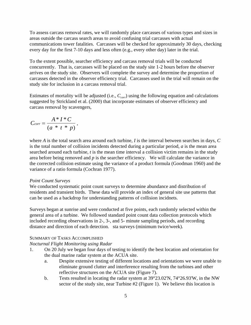
Estimates of mortality will be adjusted (i.e., Ccorr) using the following equation and calculationssuggested by Strickland et al. (2000) that incorporate estimates of observer efficiency andcarcass removal by scavengers,
,C A I Ca
corr =* *
( * ) * t p
where A is the total search area around each turbine, I is the interval between searches in days, Cis the total number of collision incidents detected during a particular period, a is the mean areasearched around each turbine, t is the mean time interval a collision victim remains in the studyarea before being removed and p is the searcher efficiency. We will calculate the variance inthe corrected collision estimate using the variance of a product formula (Goodman 1960) and thevariance of a ratio formula (Cochran 1977).
Point Count SurveysWe conducted systematic point count surveys to determine abundance and distribution ofresidents and transient birds. These data will provide an index of general site use patterns thatcan be used as a backdrop for understanding patterns of collision incidnets.
Surveys began at sunrise and were conducted at five points, each randomly selected within thegeneral area of a turbine. We followed standard point count data collection protocols whichincluded recording observations in 2-, 3-, and 5- minute sampling periods, and recordingdistance and direction of each detection. sta surveys (minimum twice/week).
SUMMARY OF TASKS ACCOMPLISHEDNocturnal Flight Monitoring using Radar1. On 20 July we began four days of testing to identify the best location and orientation for
the dual marine radar system at the ACUA site. a. Despite extensive testing of different locations and orientations we were unable to
eliminate ground clutter and interference resulting from the turbines and otherreflective structures on the ACUA site (Figure 7).
b. Tests resulted in locating the radar system at 39°23.02'N, 74°26.93'W, in the NWsector of the study site, near Turbine #2 (Figure 1). We believe this location is
6
least susceptible to ground clutter and interference.2. On the evening of 25 July we began data collection. Typically, we collected data
following a schedule of five days on, two days off through 4 December with occassionalslight deviations (Table 1). Afterwards, we reduced our radar survey (~two days/ weekto reflect reduced migration traffic in December. a. Through the reporting period, we collected data on 96 days, for approximately 24
hours/day.b. This results in approximately 720 data images per day, per radar. Approximately
69,120 images/radar were collected during the reporting period.
Collision Incident Monitoring1. On 30 July 2007, we began laying out transects for collision incident surveys. We used a
GPS and rangefinder to mark the corners of survey areas around each turbine and markthe survey transects in each turbine's survey area.
2. This preliminary work was completed on 5 August and collision incident surveyscommenced on 6 August 2007
3. Surveys were conducted Mondays, Wednesdays and Fridays in each of 20 weeks of thereporting period through the week of 17 December. a. During these surveys, NJAS's observer detected 31 dead bats (Table 2) and 9 dead
birds (Table 3), one of which was not attributed to a collision with a wind turbineb. Two observer efficiency and scavenger removal trials were conducted during the
reporting period.c. These data presented in this report represent raw counts of collision incidents and
are not corrected for proportion of survey area covered, observer detectability orcarcass removal.
Point Count Surveys1. Starting the week of 6 August 2007, NJAS's observer conducted weekly point counts to
determine the abundance and distribution of birds on the ACUA study site.2. Results of these surveys are shown in Table 4.
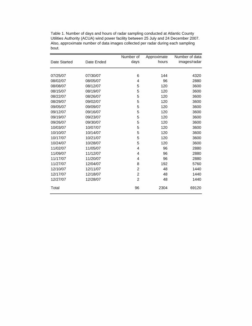
Table 1. Number of days and hours of radar sampling conducted at Atlantic County Utilities Authority (ACUA) wind power facility between 25 July and 24 December 2007. Also, approximate number of data images collected per radar during each sampling bout.
Date Started Date EndedNumber of
days Approximate
hours Number of data
images/radar
07/25/07 07/30/07 6 144 432008/02/07 08/05/07 4 96 288008/08/07 08/12/07 5 120 360008/15/07 08/19/07 5 120 360008/22/07 08/26/07 5 120 360008/29/07 09/02/07 5 120 360009/05/07 09/09/07 5 120 360009/12/07 09/16/07 5 120 360009/19/07 09/23/07 5 120 360009/26/07 09/30/07 5 120 360010/03/07 10/07/07 5 120 360010/10/07 10/14/07 5 120 360010/17/07 10/21/07 5 120 360010/24/07 10/28/07 5 120 360011/02/07 11/05/07 4 96 288011/09/07 11/12/07 4 96 288011/17/07 11/20/07 4 96 288011/27/07 12/04/07 8 192 576012/10/07 12/11/07 2 48 144012/17/07 12/18/07 2 48 144012/27/07 12/28/07 2 48 1440
Total 96 2304 69120
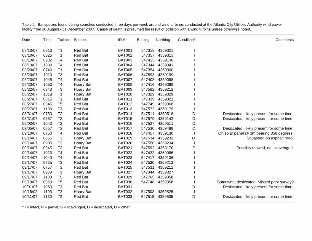
Date Time Turbine Species ID # Easting Northing Condition* Comments
08/10/07 0810 T1 Red Bat BAT001 547318 4359321 I08/10/07 0825 T1 Red Bat BAT002 547357 4359313 I08/13/07 0932 T4 Red Bat BAT003 547413 4359138 I08/13/07 1000 T4 Red Bat BAT004 547344 4359341 I08/20/07 0740 T1 Red Bat BAT005 547354 4359300 I08/20/07 1010 T3 Red Bat BAT006 547593 4359199 I08/20/07 1045 T4 Red Bat BAT007 547408 4359098 I08/20/07 1050 T4 Hoary Bat BAT008 547416 4359099 I08/22/07 0843 T3 Hoary Bat BAT009 547582 4359212 I08/22/07 1018 T1 Hoary Bat BAT010 547329 4359329 I08/27/07 0815 T1 Red Bat BAT011 547339 4359321 I08/27/07 0945 T5 Red Bat BAT012 547749 4359368 I08/27/07 1100 T3 Red Bat BAT013 547572 4359179 I08/31/07 0750 T2 Red Bat BAT014 547511 4359518 D Desiccated, likely present for some time.08/31/07 0857 T3 Red Bat BAT015 547579 4359142 D Desiccated, likely present for some time.09/03/07 1043 T2 Red Bat BAT016 547527 4359511 D09/05/07 0857 T2 Red Bat BAT017 547530 4359488 D Desiccated, likely present for some time.09/10/07 0750 T4 Red Bat BAT018 547457 4359130 I On solar panel @ 3m bearing 358 degrees.09/14/07 0855 T3 Hoary Bat BAT019 547534 4359232 O Squashed on asphalt road.09/14/07 0905 T3 Hoary Bat BAT020 547550 4359234 I09/14/07 0945 T3 Red Bat BAT021 547592 4359170 P Possibly mowed, not scavenged.09/14/07 1023 T4 Red Bat BAT022 547422 4359086 I09/14/07 1040 T4 Red Bat BAT023 547417 4359136 I09/17/07 0755 T3 Red Bat BAT024 547530 4359213 I09/17/07 0757 T3 Red Bat BAT025 547531 4359211 I09/17/07 0958 T1 Hoary Bat BAT027 547344 4359327 I09/17/07 1103 T5 Red Bat BAT029 547765 4359358 I09/19/07 0953 T5 Red Bat BAT030 547748 4359358 I Somewhat desiccated. Missed prev survey?10/01/07 1053 T3 Red Bat BAT031 - - D Desiccated, likely present for some time.10/18/02 1103 T2 Hoary Bat BAT032 547503 4359525 I10/31/07 1130 T2 Red Bat BAT033 547515 4359505 D Desiccated, likely present for some time.
* I = Intact, P = partial, S = scavenged, D = desiccated, O = other
Table 2. Bat species found during searches conducted three days per week around wind turbines conducted at the Atlantic City Utilities Authority wind power facility from 10 August - 31 December 2007. Cause of death is presumed the result of collision with a wind turbine unless otherwise noted.
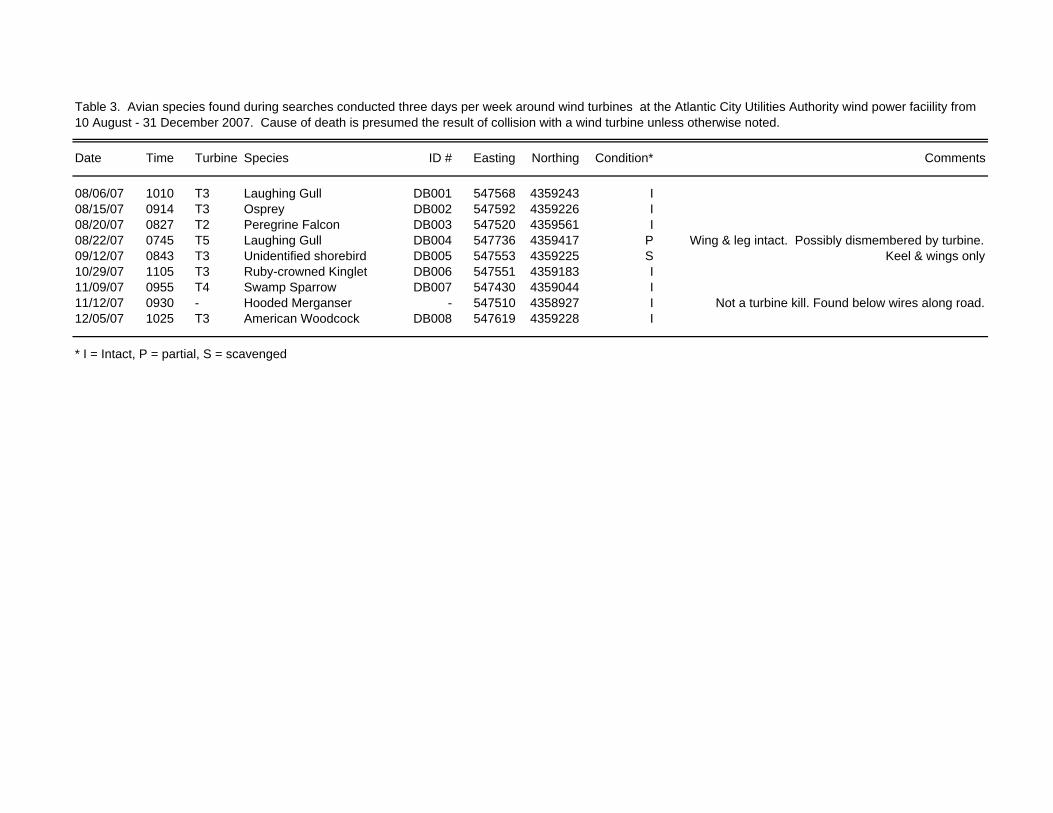
Table 3. Avian species found during searches conducted three days per week around wind turbines at the Atlantic City Utilities Authority wind power faciility from 10 August - 31 December 2007. Cause of death is presumed the result of collision with a wind turbine unless otherwise noted.
Date Time Turbine Species ID # Easting Northing Condition* Comments
08/06/07 1010 T3 Laughing Gull DB001 547568 4359243 I08/15/07 0914 T3 Osprey DB002 547592 4359226 I08/20/07 0827 T2 Peregrine Falcon DB003 547520 4359561 I08/22/07 0745 T5 Laughing Gull DB004 547736 4359417 P Wing & leg intact. Possibly dismembered by turbine.09/12/07 0843 T3 Unidentified shorebird DB005 547553 4359225 S Keel & wings only10/29/07 1105 T3 Ruby-crowned Kinglet DB006 547551 4359183 I11/09/07 0955 T4 Swamp Sparrow DB007 547430 4359044 I11/12/07 0930 - Hooded Merganser - 547510 4358927 I Not a turbine kill. Found below wires along road.12/05/07 1025 T3 American Woodcock DB008 547619 4359228 I
* I = Intact, P = partial, S = scavenged
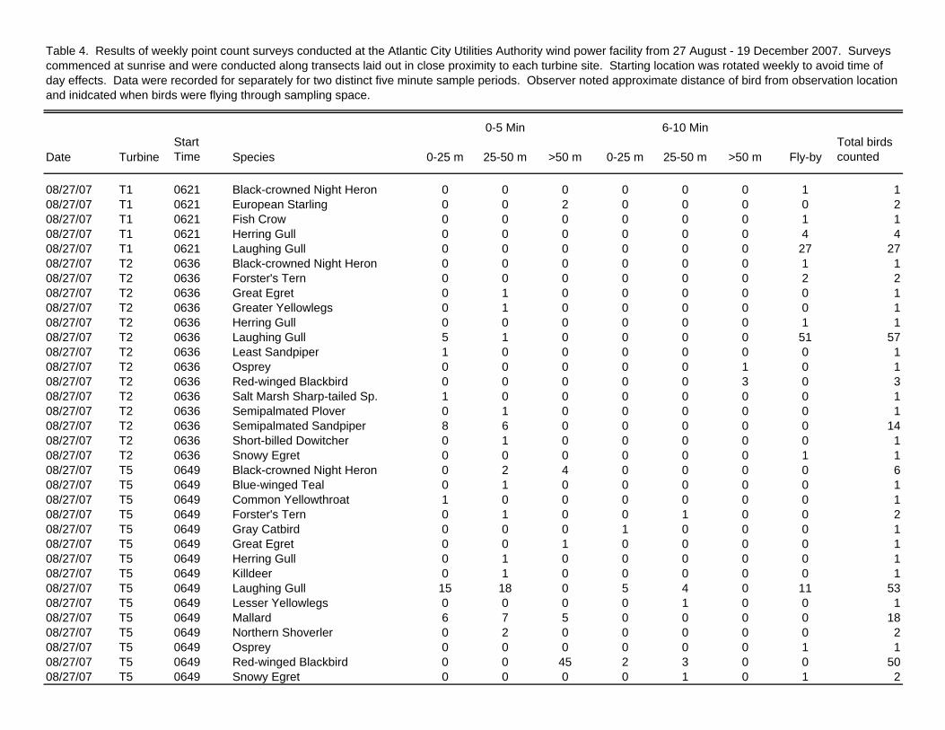
Table 4. Results of weekly point count surveys conducted at the Atlantic City Utilities Authority wind power facility from 27 August - 19 December 2007. Surveys commenced at sunrise and were conducted along transects laid out in close proximity to each turbine site. Starting location was rotated weekly to avoid time of day effects. Data were recorded for separately for two distinct five minute sample periods. Observer noted approximate distance of bird from observation location and inidcated when birds were flying through sampling space.
0-5 Min 6-10 Min
Date TurbineStart Time Species 0-25 m 25-50 m >50 m 0-25 m 25-50 m >50 m Fly-by
Total birds counted
08/27/07 T1 0621 Black-crowned Night Heron 0 0 0 0 0 0 1 108/27/07 T1 0621 European Starling 0 0 2 0 0 0 0 208/27/07 T1 0621 Fish Crow 0 0 0 0 0 0 1 108/27/07 T1 0621 Herring Gull 0 0 0 0 0 0 4 408/27/07 T1 0621 Laughing Gull 0 0 0 0 0 0 27 2708/27/07 T2 0636 Black-crowned Night Heron 0 0 0 0 0 0 1 108/27/07 T2 0636 Forster's Tern 0 0 0 0 0 0 2 208/27/07 T2 0636 Great Egret 0 1 0 0 0 0 0 108/27/07 T2 0636 Greater Yellowlegs 0 1 0 0 0 0 0 108/27/07 T2 0636 Herring Gull 0 0 0 0 0 0 1 108/27/07 T2 0636 Laughing Gull 5 1 0 0 0 0 51 5708/27/07 T2 0636 Least Sandpiper 1 0 0 0 0 0 0 108/27/07 T2 0636 Osprey 0 0 0 0 0 1 0 108/27/07 T2 0636 Red-winged Blackbird 0 0 0 0 0 3 0 308/27/07 T2 0636 Salt Marsh Sharp-tailed Sp. 1 0 0 0 0 0 0 108/27/07 T2 0636 Semipalmated Plover 0 1 0 0 0 0 0 108/27/07 T2 0636 Semipalmated Sandpiper 8 6 0 0 0 0 0 1408/27/07 T2 0636 Short-billed Dowitcher 0 1 0 0 0 0 0 108/27/07 T2 0636 Snowy Egret 0 0 0 0 0 0 1 108/27/07 T5 0649 Black-crowned Night Heron 0 2 4 0 0 0 0 608/27/07 T5 0649 Blue-winged Teal 0 1 0 0 0 0 0 108/27/07 T5 0649 Common Yellowthroat 1 0 0 0 0 0 0 108/27/07 T5 0649 Forster's Tern 0 1 0 0 1 0 0 208/27/07 T5 0649 Gray Catbird 0 0 0 1 0 0 0 108/27/07 T5 0649 Great Egret 0 0 1 0 0 0 0 108/27/07 T5 0649 Herring Gull 0 1 0 0 0 0 0 108/27/07 T5 0649 Killdeer 0 1 0 0 0 0 0 108/27/07 T5 0649 Laughing Gull 15 18 0 5 4 0 11 5308/27/07 T5 0649 Lesser Yellowlegs 0 0 0 0 1 0 0 108/27/07 T5 0649 Mallard 6 7 5 0 0 0 0 1808/27/07 T5 0649 Northern Shoverler 0 2 0 0 0 0 0 208/27/07 T5 0649 Osprey 0 0 0 0 0 0 1 108/27/07 T5 0649 Red-winged Blackbird 0 0 45 2 3 0 0 5008/27/07 T5 0649 Snowy Egret 0 0 0 0 1 0 1 2
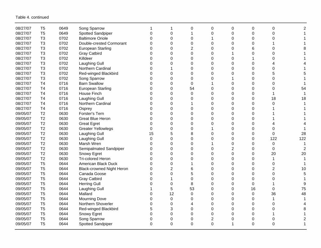
Table 4. continued
08/27/07 T5 0649 Song Sparrow 1 1 0 0 0 0 0 208/27/07 T5 0649 Spotted Sandpiper 0 0 1 0 0 0 0 108/27/07 T3 0702 Baltimore Oriole 0 0 0 1 0 0 0 108/27/07 T3 0702 Double-crested Cormorant 0 0 0 0 0 0 1 108/27/07 T3 0702 European Starling 0 0 2 0 0 6 0 808/27/07 T3 0702 Gray Catbird 0 0 0 0 1 0 0 108/27/07 T3 0702 Killdeer 0 0 0 0 0 1 0 108/27/07 T3 0702 Laughing Gull 0 0 0 0 0 0 4 408/27/07 T3 0702 Northern Cardinal 0 1 0 0 0 0 0 108/27/07 T3 0702 Red-winged Blackbird 0 0 0 0 0 0 5 508/27/07 T3 0702 Song Sparrow 0 0 0 0 1 0 0 108/27/07 T4 0716 Barn Swallow 0 0 0 1 0 0 0 108/27/07 T4 0716 European Starling 0 0 54 0 0 0 0 5408/27/07 T4 0716 House Finch 0 0 0 0 0 0 1 108/27/07 T4 0716 Laughing Gull 0 0 0 0 0 0 18 1808/27/07 T4 0716 Northern Cardinal 0 0 1 0 0 0 0 108/27/07 T4 0716 Osprey 0 0 0 0 0 0 1 109/05/07 T2 0630 Forster's Tern 0 0 0 0 0 0 1 109/05/07 T2 0630 Great Blue Heron 0 0 0 0 0 0 1 109/05/07 T2 0630 Great Egret 0 0 0 0 0 0 4 409/05/07 T2 0630 Greater Yellowlegs 0 0 0 1 0 0 0 109/05/07 T2 0630 Laughing Gull 15 5 8 0 0 0 0 2809/05/07 T2 0630 Laughing Gull 0 0 0 0 0 0 122 12209/05/07 T2 0630 Marsh Wren 0 0 0 1 0 0 0 109/05/07 T2 0630 Semipalmated Sandpiper 0 0 0 0 2 0 0 209/05/07 T2 0630 Snowy Egret 0 0 0 0 0 0 20 2009/05/07 T2 0630 Tri-colored Heron 0 0 0 0 0 0 1 109/05/07 T5 0644 American Black Duck 0 0 1 0 0 0 0 109/05/07 T5 0644 Black-crowned Night Heron 0 2 6 0 0 0 2 1009/05/07 T5 0644 Canada Goose 0 0 5 0 0 0 0 509/05/07 T5 0644 Gray Catbird 0 1 0 0 0 0 0 109/05/07 T5 0644 Herring Gull 0 0 8 0 0 0 1 909/05/07 T5 0644 Laughing Gull 1 5 53 0 0 16 0 7509/05/07 T5 0644 Mallard 0 12 0 0 0 0 36 4809/05/07 T5 0644 Mourning Dove 0 0 0 0 0 0 1 109/05/07 T5 0644 Northern Shoverler 0 0 4 0 0 0 0 409/05/07 T5 0644 Red-winged Blackbird 5 3 0 0 0 0 0 809/05/07 T5 0644 Snowy Egret 0 0 0 0 0 0 1 109/05/07 T5 0644 Song Sparrow 0 0 0 2 0 0 0 209/05/07 T5 0644 Spotted Sandpiper 0 0 0 0 1 0 0 1
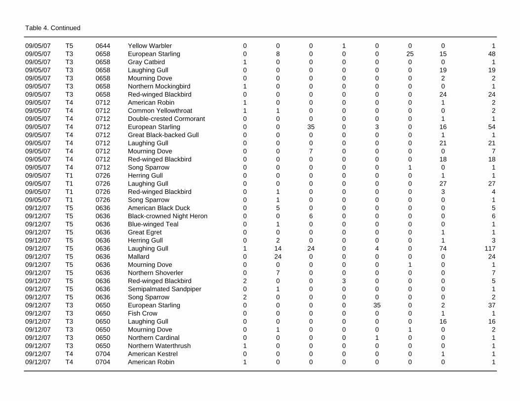
Table 4. Continued
09/05/07 T5 0644 Yellow Warbler 0 0 0 1 0 0 0 109/05/07 T3 0658 European Starling 0 8 0 0 0 25 15 4809/05/07 T3 0658 Gray Catbird 1 0 0 0 0 0 0 109/05/07 T3 0658 Laughing Gull 0 0 0 0 0 0 19 1909/05/07 T3 0658 Mourning Dove 0 0 0 0 0 0 2 209/05/07 T3 0658 Northern Mockingbird 1 0 0 0 0 0 0 109/05/07 T3 0658 Red-winged Blackbird 0 0 0 0 0 0 24 2409/05/07 T4 0712 American Robin 1 0 0 0 0 0 1 209/05/07 T4 0712 Common Yellowthroat 1 1 0 0 0 0 0 209/05/07 T4 0712 Double-crested Cormorant 0 0 0 0 0 0 1 109/05/07 T4 0712 European Starling 0 0 35 0 3 0 16 5409/05/07 T4 0712 Great Black-backed Gull 0 0 0 0 0 0 1 109/05/07 T4 0712 Laughing Gull 0 0 0 0 0 0 21 2109/05/07 T4 0712 Mourning Dove 0 0 7 0 0 0 0 709/05/07 T4 0712 Red-winged Blackbird 0 0 0 0 0 0 18 1809/05/07 T4 0712 Song Sparrow 0 0 0 0 0 1 0 109/05/07 T1 0726 Herring Gull 0 0 0 0 0 0 1 109/05/07 T1 0726 Laughing Gull 0 0 0 0 0 0 27 2709/05/07 T1 0726 Red-winged Blackbird 0 1 0 0 0 0 3 409/05/07 T1 0726 Song Sparrow 0 1 0 0 0 0 0 109/12/07 T5 0636 American Black Duck 0 5 0 0 0 0 0 509/12/07 T5 0636 Black-crowned Night Heron 0 0 6 0 0 0 0 609/12/07 T5 0636 Blue-winged Teal 0 1 0 0 0 0 0 109/12/07 T5 0636 Great Egret 0 0 0 0 0 0 1 109/12/07 T5 0636 Herring Gull 0 2 0 0 0 0 1 309/12/07 T5 0636 Laughing Gull 1 14 24 0 4 0 74 11709/12/07 T5 0636 Mallard 0 24 0 0 0 0 0 2409/12/07 T5 0636 Mourning Dove 0 0 0 0 0 1 0 109/12/07 T5 0636 Northern Shoverler 0 7 0 0 0 0 0 709/12/07 T5 0636 Red-winged Blackbird 2 0 0 3 0 0 0 509/12/07 T5 0636 Semipalmated Sandpiper 0 1 0 0 0 0 0 109/12/07 T5 0636 Song Sparrow 2 0 0 0 0 0 0 209/12/07 T3 0650 European Starling 0 0 0 0 35 0 2 3709/12/07 T3 0650 Fish Crow 0 0 0 0 0 0 1 109/12/07 T3 0650 Laughing Gull 0 0 0 0 0 0 16 1609/12/07 T3 0650 Mourning Dove 0 1 0 0 0 1 0 209/12/07 T3 0650 Northern Cardinal 0 0 0 0 1 0 0 109/12/07 T3 0650 Northern Waterthrush 1 0 0 0 0 0 0 109/12/07 T4 0704 American Kestrel 0 0 0 0 0 0 1 109/12/07 T4 0704 American Robin 1 0 0 0 0 0 0 1
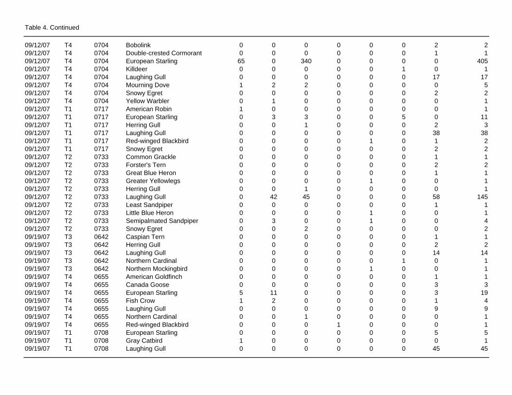
Table 4. Continued
09/12/07 T4 0704 Bobolink 0 0 0 0 0 0 2 209/12/07 T4 0704 Double-crested Cormorant 0 0 0 0 0 0 1 109/12/07 T4 0704 European Starling 65 0 340 0 0 0 0 40509/12/07 T4 0704 Killdeer 0 0 0 0 0 1 0 109/12/07 T4 0704 Laughing Gull 0 0 0 0 0 0 17 1709/12/07 T4 0704 Mourning Dove 1 2 2 0 0 0 0 509/12/07 T4 0704 Snowy Egret 0 0 0 0 0 0 2 209/12/07 T4 0704 Yellow Warbler 0 1 0 0 0 0 0 109/12/07 T1 0717 American Robin 1 0 0 0 0 0 0 109/12/07 T1 0717 European Starling 0 3 3 0 0 5 0 1109/12/07 T1 0717 Herring Gull 0 0 1 0 0 0 2 309/12/07 T1 0717 Laughing Gull 0 0 0 0 0 0 38 3809/12/07 T1 0717 Red-winged Blackbird 0 0 0 0 1 0 1 209/12/07 T1 0717 Snowy Egret 0 0 0 0 0 0 2 209/12/07 T2 0733 Common Grackle 0 0 0 0 0 0 1 109/12/07 T2 0733 Forster's Tern 0 0 0 0 0 0 2 209/12/07 T2 0733 Great Blue Heron 0 0 0 0 0 0 1 109/12/07 T2 0733 Greater Yellowlegs 0 0 0 0 1 0 0 109/12/07 T2 0733 Herring Gull 0 0 1 0 0 0 0 109/12/07 T2 0733 Laughing Gull 0 42 45 0 0 0 58 14509/12/07 T2 0733 Least Sandpiper 0 0 0 0 0 0 1 109/12/07 T2 0733 Little Blue Heron 0 0 0 0 1 0 0 109/12/07 T2 0733 Semipalmated Sandpiper 0 3 0 0 1 0 0 409/12/07 T2 0733 Snowy Egret 0 0 2 0 0 0 0 209/19/07 T3 0642 Caspian Tern 0 0 0 0 0 0 1 109/19/07 T3 0642 Herring Gull 0 0 0 0 0 0 2 209/19/07 T3 0642 Laughing Gull 0 0 0 0 0 0 14 1409/19/07 T3 0642 Northern Cardinal 0 0 0 0 0 1 0 109/19/07 T3 0642 Northern Mockingbird 0 0 0 0 1 0 0 109/19/07 T4 0655 American Goldfinch 0 0 0 0 0 0 1 109/19/07 T4 0655 Canada Goose 0 0 0 0 0 0 3 309/19/07 T4 0655 European Starling 5 11 0 0 0 0 3 1909/19/07 T4 0655 Fish Crow 1 2 0 0 0 0 1 409/19/07 T4 0655 Laughing Gull 0 0 0 0 0 0 9 909/19/07 T4 0655 Northern Cardinal 0 0 1 0 0 0 0 109/19/07 T4 0655 Red-winged Blackbird 0 0 0 1 0 0 0 109/19/07 T1 0708 European Starling 0 0 0 0 0 0 5 509/19/07 T1 0708 Gray Catbird 1 0 0 0 0 0 0 109/19/07 T1 0708 Laughing Gull 0 0 0 0 0 0 45 45
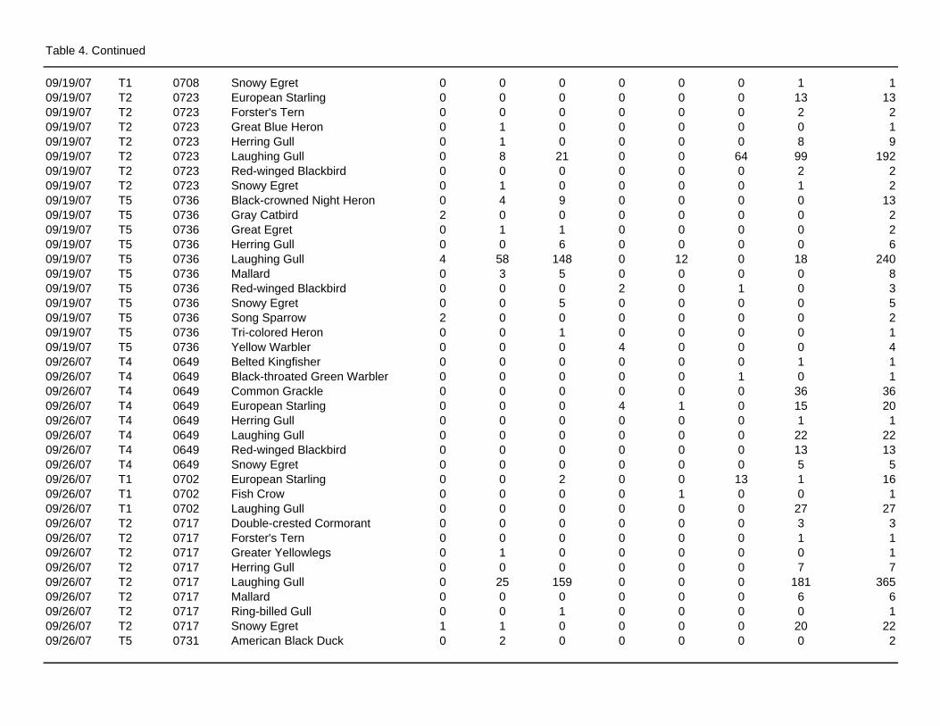
Table 4. Continued
09/19/07 T1 0708 Snowy Egret 0 0 0 0 0 0 1 109/19/07 T2 0723 European Starling 0 0 0 0 0 0 13 1309/19/07 T2 0723 Forster's Tern 0 0 0 0 0 0 2 209/19/07 T2 0723 Great Blue Heron 0 1 0 0 0 0 0 109/19/07 T2 0723 Herring Gull 0 1 0 0 0 0 8 909/19/07 T2 0723 Laughing Gull 0 8 21 0 0 64 99 19209/19/07 T2 0723 Red-winged Blackbird 0 0 0 0 0 0 2 209/19/07 T2 0723 Snowy Egret 0 1 0 0 0 0 1 209/19/07 T5 0736 Black-crowned Night Heron 0 4 9 0 0 0 0 1309/19/07 T5 0736 Gray Catbird 2 0 0 0 0 0 0 209/19/07 T5 0736 Great Egret 0 1 1 0 0 0 0 209/19/07 T5 0736 Herring Gull 0 0 6 0 0 0 0 609/19/07 T5 0736 Laughing Gull 4 58 148 0 12 0 18 24009/19/07 T5 0736 Mallard 0 3 5 0 0 0 0 809/19/07 T5 0736 Red-winged Blackbird 0 0 0 2 0 1 0 309/19/07 T5 0736 Snowy Egret 0 0 5 0 0 0 0 509/19/07 T5 0736 Song Sparrow 2 0 0 0 0 0 0 209/19/07 T5 0736 Tri-colored Heron 0 0 1 0 0 0 0 109/19/07 T5 0736 Yellow Warbler 0 0 0 4 0 0 0 409/26/07 T4 0649 Belted Kingfisher 0 0 0 0 0 0 1 109/26/07 T4 0649 Black-throated Green Warbler 0 0 0 0 0 1 0 109/26/07 T4 0649 Common Grackle 0 0 0 0 0 0 36 3609/26/07 T4 0649 European Starling 0 0 0 4 1 0 15 2009/26/07 T4 0649 Herring Gull 0 0 0 0 0 0 1 109/26/07 T4 0649 Laughing Gull 0 0 0 0 0 0 22 2209/26/07 T4 0649 Red-winged Blackbird 0 0 0 0 0 0 13 1309/26/07 T4 0649 Snowy Egret 0 0 0 0 0 0 5 509/26/07 T1 0702 European Starling 0 0 2 0 0 13 1 1609/26/07 T1 0702 Fish Crow 0 0 0 0 1 0 0 109/26/07 T1 0702 Laughing Gull 0 0 0 0 0 0 27 2709/26/07 T2 0717 Double-crested Cormorant 0 0 0 0 0 0 3 309/26/07 T2 0717 Forster's Tern 0 0 0 0 0 0 1 109/26/07 T2 0717 Greater Yellowlegs 0 1 0 0 0 0 0 109/26/07 T2 0717 Herring Gull 0 0 0 0 0 0 7 709/26/07 T2 0717 Laughing Gull 0 25 159 0 0 0 181 36509/26/07 T2 0717 Mallard 0 0 0 0 0 0 6 609/26/07 T2 0717 Ring-billed Gull 0 0 1 0 0 0 0 109/26/07 T2 0717 Snowy Egret 1 1 0 0 0 0 20 2209/26/07 T5 0731 American Black Duck 0 2 0 0 0 0 0 2
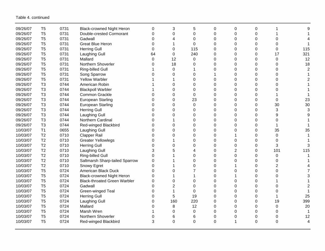
Table 4. continued
09/26/07 T5 0731 Black-crowned Night Heron 0 3 5 0 0 0 1 909/26/07 T5 0731 Double-crested Cormorant 0 0 0 0 0 0 1 109/26/07 T5 0731 Gadwall 0 4 0 0 0 0 0 409/26/07 T5 0731 Great Blue Heron 0 1 0 0 0 0 0 109/26/07 T5 0731 Herring Gull 0 0 115 0 0 0 0 11509/26/07 T5 0731 Laughing Gull 64 0 240 0 0 0 17 32109/26/07 T5 0731 Mallard 0 12 0 0 0 0 0 1209/26/07 T5 0731 Northern Shoverler 0 18 0 0 0 0 0 1809/26/07 T5 0731 Ring-billed Gull 1 0 1 0 0 0 0 209/26/07 T5 0731 Song Sparrow 0 0 0 1 0 0 0 109/26/07 T5 0731 Yellow Warbler 1 1 0 0 0 0 0 209/26/07 T3 0744 American Robin 1 0 0 0 0 0 0 109/26/07 T3 0744 Blackpoll Warbler 1 0 0 0 0 0 0 109/26/07 T3 0744 Common Grackle 0 0 0 0 0 0 1 109/26/07 T3 0744 European Starling 0 0 23 0 0 0 0 2309/26/07 T3 0744 European Starling 0 0 0 0 0 0 30 3009/26/07 T3 0744 Herring Gull 0 0 0 0 0 0 3 309/26/07 T3 0744 Laughing Gull 0 0 0 0 0 0 9 909/26/07 T3 0744 Northern Cardinal 0 1 0 0 0 0 0 109/26/07 T3 0744 Red-winged Blackbird 0 0 0 0 0 0 1 110/03/07 T1 0655 Laughing Gull 0 0 0 0 0 0 35 3510/03/07 T2 0710 Clapper Rail 0 0 0 0 1 0 0 110/03/07 T2 0710 Greater Yellowlegs 0 1 0 0 0 0 0 110/03/07 T2 0710 Herring Gull 0 0 0 0 0 0 3 310/03/07 T2 0710 Laughing Gull 3 5 4 0 2 0 101 11510/03/07 T2 0710 Ring-billed Gull 0 1 0 0 0 0 0 110/03/07 T2 0710 Saltmarsh Sharp-tailed Sparrow 0 1 0 0 0 0 0 110/03/07 T2 0710 Snowy Egret 0 1 0 0 1 0 2 410/03/07 T5 0724 American Black Duck 0 0 7 0 0 0 0 710/03/07 T5 0724 Black-crowned Night Heron 0 1 1 0 1 0 0 310/03/07 T5 0724 Black-throated Green Warbler 0 0 0 0 0 0 1 110/03/07 T5 0724 Gadwall 0 2 0 0 0 0 0 210/03/07 T5 0724 Green-winged Teal 0 1 0 0 0 0 0 110/03/07 T5 0724 Herring Gull 0 5 19 0 0 0 1 2510/03/07 T5 0724 Laughing Gull 0 160 220 0 0 0 19 39910/03/07 T5 0724 Mallard 0 8 12 0 0 0 0 2010/03/07 T5 0724 Marsh Wren 1 0 0 0 0 0 0 110/03/07 T5 0724 Northern Shoverler 0 6 6 0 0 0 0 1210/03/07 T5 0724 Red-winged Blackbird 3 0 0 0 1 0 0 4
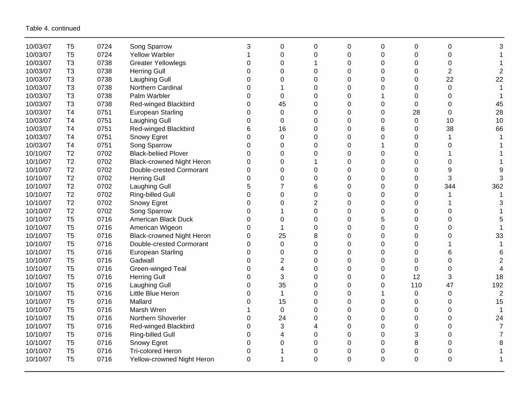
Table 4. continued
10/03/07 T5 0724 Song Sparrow 3 0 0 0 0 0 0 310/03/07 T5 0724 Yellow Warbler 1 0 0 0 0 0 0 110/03/07 T3 0738 Greater Yellowlegs 0 0 1 0 0 0 0 110/03/07 T3 0738 Herring Gull 0 0 0 0 0 0 2 210/03/07 T3 0738 Laughing Gull 0 0 0 0 0 0 22 2210/03/07 T3 0738 Northern Cardinal 0 1 0 0 0 0 0 110/03/07 T3 0738 Palm Warbler 0 0 0 0 1 0 0 110/03/07 T3 0738 Red-winged Blackbird 0 45 0 0 0 0 0 4510/03/07 T4 0751 European Starling 0 0 0 0 0 28 0 2810/03/07 T4 0751 Laughing Gull 0 0 0 0 0 0 10 1010/03/07 T4 0751 Red-winged Blackbird 6 16 0 0 6 0 38 6610/03/07 T4 0751 Snowy Egret 0 0 0 0 0 0 1 110/03/07 T4 0751 Song Sparrow 0 0 0 0 1 0 0 110/10/07 T2 0702 Black-beliied Plover 0 0 0 0 0 0 1 110/10/07 T2 0702 Black-crowned Night Heron 0 0 1 0 0 0 0 110/10/07 T2 0702 Double-crested Cormorant 0 0 0 0 0 0 9 910/10/07 T2 0702 Herring Gull 0 0 0 0 0 0 3 310/10/07 T2 0702 Laughing Gull 5 7 6 0 0 0 344 36210/10/07 T2 0702 Ring-billed Gull 0 0 0 0 0 0 1 110/10/07 T2 0702 Snowy Egret 0 0 2 0 0 0 1 310/10/07 T2 0702 Song Sparrow 0 1 0 0 0 0 0 110/10/07 T5 0716 American Black Duck 0 0 0 0 5 0 0 510/10/07 T5 0716 American Wigeon 0 1 0 0 0 0 0 110/10/07 T5 0716 Black-crowned Night Heron 0 25 8 0 0 0 0 3310/10/07 T5 0716 Double-crested Cormorant 0 0 0 0 0 0 1 110/10/07 T5 0716 European Starling 0 0 0 0 0 0 6 610/10/07 T5 0716 Gadwall 0 2 0 0 0 0 0 210/10/07 T5 0716 Green-winged Teal 0 4 0 0 0 0 0 410/10/07 T5 0716 Herring Gull 0 3 0 0 0 12 3 1810/10/07 T5 0716 Laughing Gull 0 35 0 0 0 110 47 19210/10/07 T5 0716 Little Blue Heron 0 1 0 0 1 0 0 210/10/07 T5 0716 Mallard 0 15 0 0 0 0 0 1510/10/07 T5 0716 Marsh Wren 1 0 0 0 0 0 0 110/10/07 T5 0716 Northern Shoverler 0 24 0 0 0 0 0 2410/10/07 T5 0716 Red-winged Blackbird 0 3 4 0 0 0 0 710/10/07 T5 0716 Ring-billed Gull 0 4 0 0 0 3 0 710/10/07 T5 0716 Snowy Egret 0 0 0 0 0 8 0 810/10/07 T5 0716 Tri-colored Heron 0 1 0 0 0 0 0 110/10/07 T5 0716 Yellow-crowned Night Heron 0 1 0 0 0 0 0 1
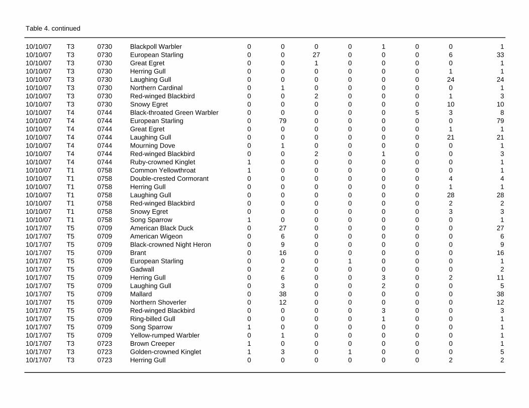
Table 4. continued
10/10/07 T3 0730 Blackpoll Warbler 0 0 0 0 1 0 0 110/10/07 T3 0730 European Starling 0 0 27 0 0 0 6 3310/10/07 T3 0730 Great Egret 0 0 1 0 0 0 0 110/10/07 T3 0730 Herring Gull 0 0 0 0 0 0 1 110/10/07 T3 0730 Laughing Gull 0 0 0 0 0 0 24 2410/10/07 T3 0730 Northern Cardinal 0 1 0 0 0 0 0 110/10/07 T3 0730 Red-winged Blackbird 0 0 2 0 0 0 1 310/10/07 T3 0730 Snowy Egret 0 0 0 0 0 0 10 1010/10/07 T4 0744 Black-throated Green Warbler 0 0 0 0 0 5 3 810/10/07 T4 0744 European Starling 0 79 0 0 0 0 0 7910/10/07 T4 0744 Great Egret 0 0 0 0 0 0 1 110/10/07 T4 0744 Laughing Gull 0 0 0 0 0 0 21 2110/10/07 T4 0744 Mourning Dove 0 1 0 0 0 0 0 110/10/07 T4 0744 Red-winged Blackbird 0 0 2 0 1 0 0 310/10/07 T4 0744 Ruby-crowned Kinglet 1 0 0 0 0 0 0 110/10/07 T1 0758 Common Yellowthroat 1 0 0 0 0 0 0 110/10/07 T1 0758 Double-crested Cormorant 0 0 0 0 0 0 4 410/10/07 T1 0758 Herring Gull 0 0 0 0 0 0 1 110/10/07 T1 0758 Laughing Gull 0 0 0 0 0 0 28 2810/10/07 T1 0758 Red-winged Blackbird 0 0 0 0 0 0 2 210/10/07 T1 0758 Snowy Egret 0 0 0 0 0 0 3 310/10/07 T1 0758 Song Sparrow 1 0 0 0 0 0 0 110/17/07 T5 0709 American Black Duck 0 27 0 0 0 0 0 2710/17/07 T5 0709 American Wigeon 0 6 0 0 0 0 0 610/17/07 T5 0709 Black-crowned Night Heron 0 9 0 0 0 0 0 910/17/07 T5 0709 Brant 0 16 0 0 0 0 0 1610/17/07 T5 0709 European Starling 0 0 0 1 0 0 0 110/17/07 T5 0709 Gadwall 0 2 0 0 0 0 0 210/17/07 T5 0709 Herring Gull 0 6 0 0 3 0 2 1110/17/07 T5 0709 Laughing Gull 0 3 0 0 2 0 0 510/17/07 T5 0709 Mallard 0 38 0 0 0 0 0 3810/17/07 T5 0709 Northern Shoverler 0 12 0 0 0 0 0 1210/17/07 T5 0709 Red-winged Blackbird 0 0 0 0 3 0 0 310/17/07 T5 0709 Ring-billed Gull 0 0 0 0 1 0 0 110/17/07 T5 0709 Song Sparrow 1 0 0 0 0 0 0 110/17/07 T5 0709 Yellow-rumped Warbler 0 1 0 0 0 0 0 110/17/07 T3 0723 Brown Creeper 1 0 0 0 0 0 0 110/17/07 T3 0723 Golden-crowned Kinglet 1 3 0 1 0 0 0 510/17/07 T3 0723 Herring Gull 0 0 0 0 0 0 2 2
Table 4. continued
10/17/07 T3 0723 Laughing Gull 0 0 0 0 0 0 1 110/17/07 T3 0723 Yellow-rumped Warbler 2 3 0 1 1 0 0 710/17/07 T4 0736 Double-crested Cormorant 0 0 0 0 0 0 1 110/17/07 T4 0736 Golden-crowned Kinglet 0 1 1 0 1 0 0 310/17/07 T4 0736 Gray Catbird 1 0 0 0 0 0 0 110/17/07 T4 0736 Great Black-backed Gull 0 0 0 0 0 0 1 110/17/07 T4 0736 Herring Gull 0 1 0 0 0 0 1 210/17/07 T4 0736 Laughing Gull 0 0 0 0 0 0 5 510/17/07 T4 0736 Northern Mockingbird 1 0 0 0 0 0 0 110/17/07 T4 0736 Red-winged Blackbird 1 0 1 0 0 0 0 210/17/07 T4 0736 Red-winged Blackbird 0 0 0 0 0 0 1 110/17/07 T4 0736 Ring-billed Gull 0 0 0 0 0 0 1 110/17/07 T4 0736 Savannah Sparrow 3 0 0 0 0 0 0 310/17/07 T4 0736 Snowy Egret 0 0 0 0 0 0 1 110/17/07 T4 0736 Song Sparrow 1 0 0 1 1 0 0 310/17/07 T4 0736 Swamp Sparrow 1 0 0 0 0 0 0 110/17/07 T1 0749 European Starling 12 6 0 0 0 0 0 1810/17/07 T1 0749 Herring Gull 0 0 0 0 0 0 4 410/17/07 T1 0749 Killdeer 0 0 1 0 0 0 0 110/17/07 T1 0749 Laughing Gull 0 0 0 0 0 0 2 210/17/07 T1 0749 Mourning Dove 2 0 0 0 0 0 0 210/17/07 T1 0749 Northern Mockingbird 1 0 0 0 0 0 0 110/17/07 T1 0749 Red-winged Blackbird 22 10 0 0 0 2 0 3410/17/07 T2 0804 American Black Duck 0 0 0 0 0 0 1 110/17/07 T2 0804 Brant 0 0 0 0 0 2 0 210/17/07 T2 0804 Canada Goose 0 0 0 0 0 0 10 1010/17/07 T2 0804 Double-crested Cormorant 0 0 0 0 1 0 2 310/17/07 T2 0804 Great Blue Heron 0 0 0 0 0 1 0 110/17/07 T2 0804 Greater Yellowlegs 0 1 0 0 0 0 0 110/17/07 T2 0804 Herring Gull 0 1 0 0 0 0 14 1510/17/07 T2 0804 Laughing Gull 0 10 0 0 0 0 7 1710/17/07 T2 0804 Osprey 0 0 0 0 0 0 1 110/17/07 T2 0804 Ring-billed Gull 0 1 0 0 0 0 7 810/31/07 T3 0724 Herring Gull 0 0 0 0 0 0 2 210/31/07 T3 0724 Northern Mockingbird 0 0 1 0 0 0 0 110/31/07 T3 0724 Red-winged Blackbird 0 0 0 0 0 0 11 1110/31/07 T3 0724 Ruby-crowned Kinglet 0 0 0 0 1 0 0 110/31/07 T3 0724 Swamp Sparrow 0 0 0 0 1 0 0 110/31/07 T3 0724 Yellow-rumped Warbler 0 1 0 0 3 0 0 4
Table 4. continued
10/31/07 T3 0724 Yellow-rumped Warbler 0 0 0 0 0 0 2 210/31/07 T4 0737 Herring Gull 0 0 0 0 0 0 6 610/31/07 T4 0737 Mourning Dove 0 0 0 0 0 0 1 110/31/07 T4 0737 Red-winged Blackbird 0 1 1 0 0 0 0 210/31/07 T4 0737 Song Sparrow 5 0 0 0 0 0 0 510/31/07 T4 0737 Swamp Sparrow 0 0 0 0 1 0 0 110/31/07 T4 0737 Yellow-rumped Warbler 0 0 0 0 0 0 1 110/31/07 T1 0750 European Starling 0 1 8 0 0 0 0 910/31/07 T1 0750 Herring Gull 0 1 0 0 0 0 3 410/31/07 T1 0750 Laughing Gull 0 0 0 0 0 0 1 110/31/07 T1 0750 Northern Mockingbird 0 0 0 0 0 1 0 110/31/07 T1 0750 Red-winged Blackbird 0 0 0 0 0 0 3 310/31/07 T1 0750 Ruby-crowned Kinglet 0 0 0 1 0 0 0 110/31/07 T1 0750 Song Sparrow 0 0 1 0 0 0 0 1

Figure 1. Dual radar system with horizontally and vertically oriented antennas that operatesimultaneously. This system allows for data collection on passage (horizontal and vertical),altitude (vertical) and flight direction (horizontal).
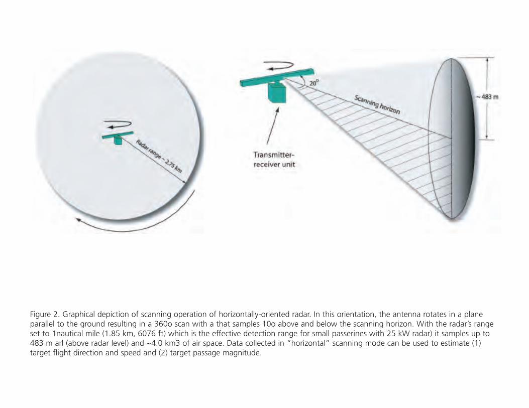
Figure 2. Graphical depiction of scanning operation of horizontally-oriented radar. In this orientation, the antenna rotates in a planeparallel to the ground resulting in a 360o scan with a that samples 10o above and below the scanning horizon. With the radar’s rangeset to 1nautical mile (1.85 km, 6076 ft) which is the effective detection range for small passerines with 25 kW radar) it samples up to483 m arl (above radar level) and ~4.0 km3 of air space. Data collected in “horizontal” scanning mode can be used to estimate (1)target flight direction and speed and (2) target passage magnitude.
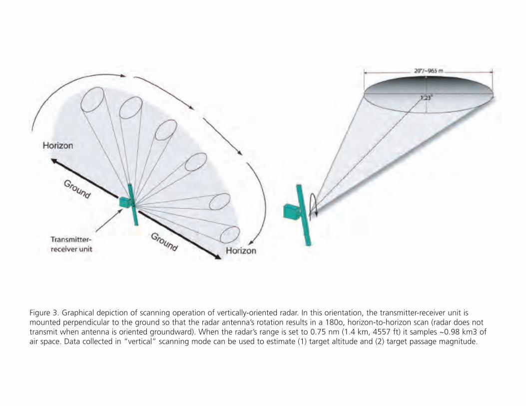
Figure 3. Graphical depiction of scanning operation of vertically-oriented radar. In this orientation, the transmitter-receiver unit ismounted perpendicular to the ground so that the radar antenna’s rotation results in a 180o, horizon-to-horizon scan (radar does nottransmit when antenna is oriented groundward). When the radar’s range is set to 0.75 nm (1.4 km, 4557 ft) it samples ~0.98 km3 ofair space. Data collected in “vertical” scanning mode can be used to estimate (1) target altitude and (2) target passage magnitude.
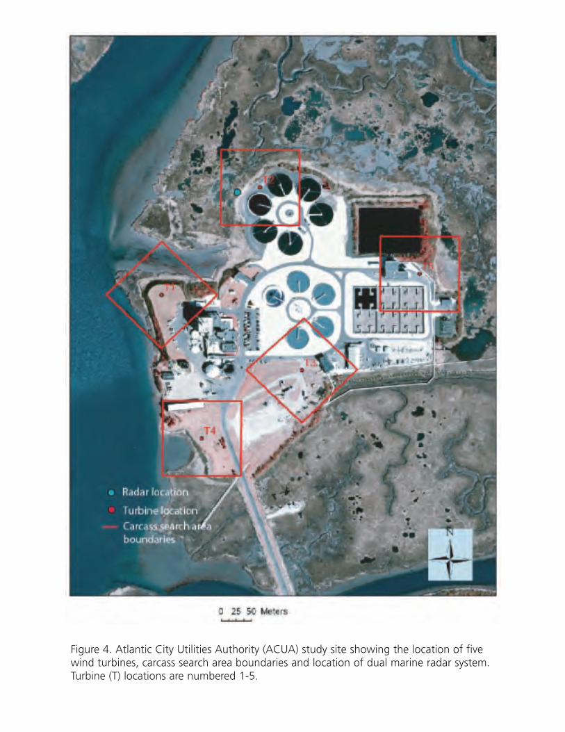
Figure 4. Atlantic City Utilities Authority (ACUA) study site showing the location of fivewind turbines, carcass search area boundaries and location of dual marine radar system.Turbine (T) locations are numbered 1-5.
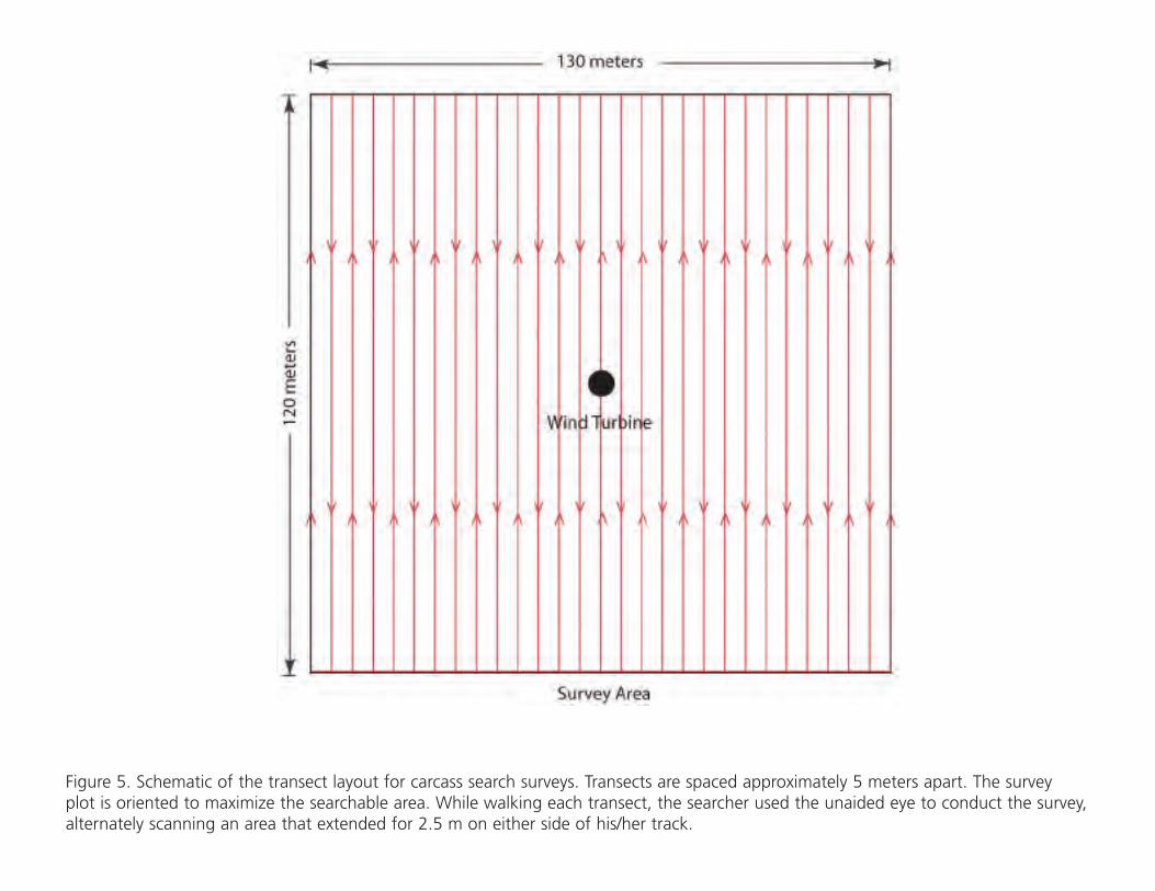
Figure 5. Schematic of the transect layout for carcass search surveys. Transects are spaced approximately 5 meters apart. The surveyplot is oriented to maximize the searchable area. While walking each transect, the searcher used the unaided eye to conduct the survey,alternately scanning an area that extended for 2.5 m on either side of his/her track.
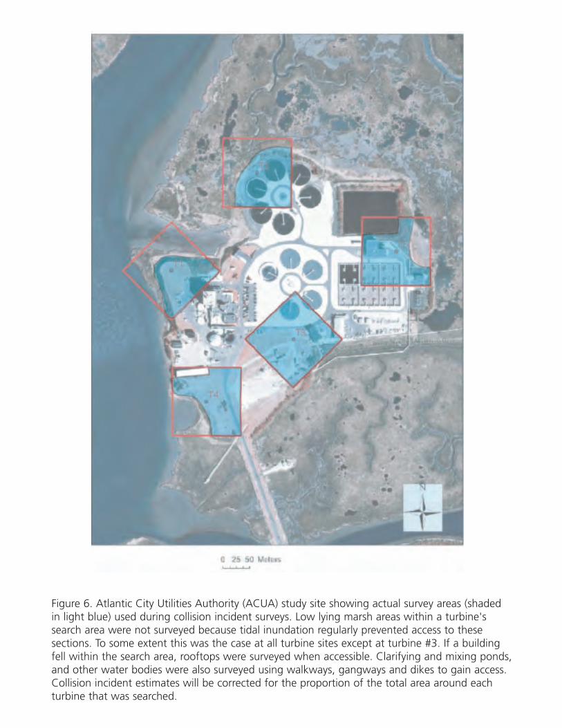
Figure 6. Atlantic City Utilities Authority (ACUA) study site showing actual survey areas (shadedin light blue) used during collision incident surveys. Low lying marsh areas within a turbine'ssearch area were not surveyed because tidal inundation regularly prevented access to thesesections. To some extent this was the case at all turbine sites except at turbine #3. If a buildingfell within the search area, rooftops were surveyed when accessible. Clarifying and mixing ponds,and other water bodies were also surveyed using walkways, gangways and dikes to gain access.Collision incident estimates will be corrected for the proportion of the total area around eachturbine that was searched.
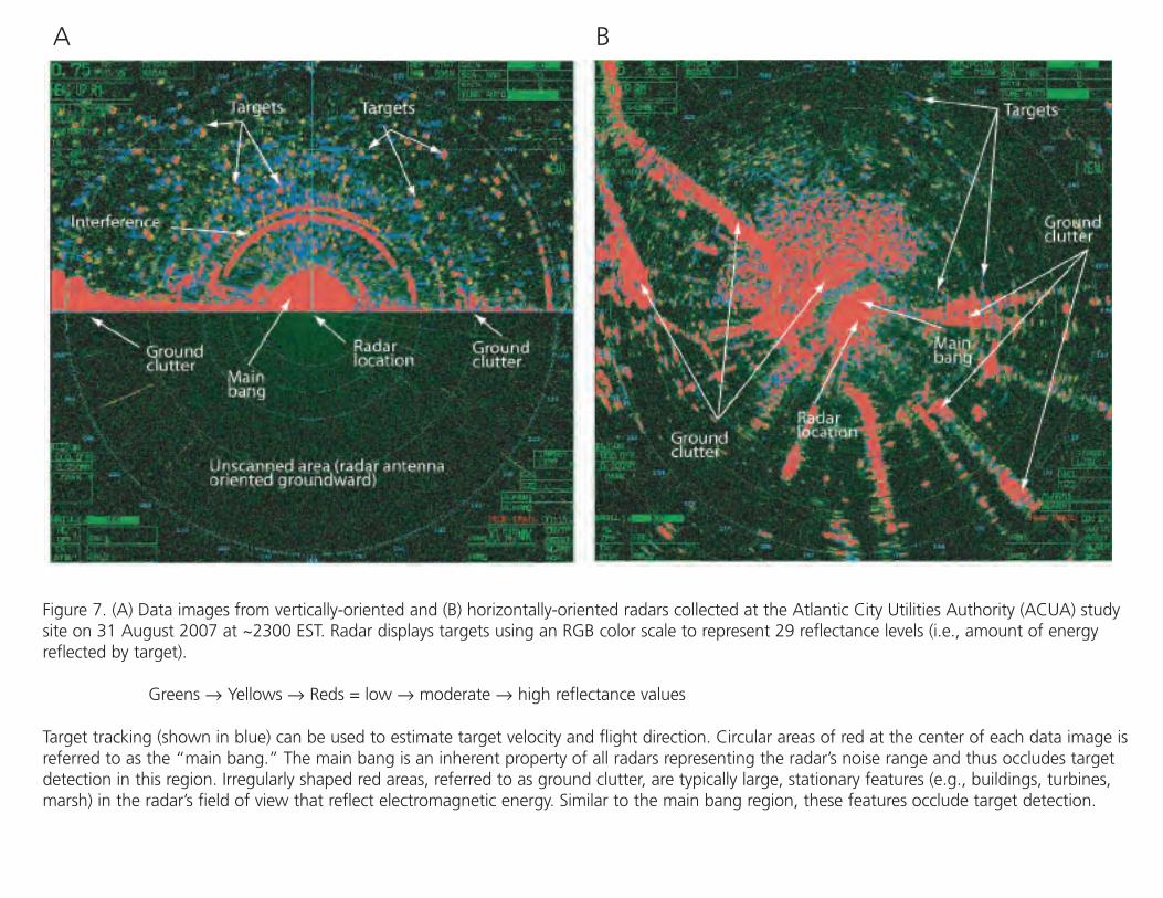
Figure 7. (A) Data images from vertically-oriented and (B) horizontally-oriented radars collected at the Atlantic City Utilities Authority (ACUA) studysite on 31 August 2007 at ~2300 EST. Radar displays targets using an RGB color scale to represent 29 reflectance levels (i.e., amount of energyreflected by target).
Greens → Yellows → Reds = low → moderate → high reflectance values
Target tracking (shown in blue) can be used to estimate target velocity and flight direction. Circular areas of red at the center of each data image isreferred to as the “main bang.” The main bang is an inherent property of all radars representing the radar’s noise range and thus occludes targetdetection in this region. Irregularly shaped red areas, referred to as ground clutter, are typically large, stationary features (e.g., buildings, turbines,marsh) in the radar’s field of view that reflect electromagnetic energy. Similar to the main bang region, these features occlude target detection.
A B