Embed Size (px)
Citation preview

PostGIS WKT RasterSpecifications Version 1.0
Seamless operations between vector and raster layers
Pierre Racine ([email protected])
University Laval, December 2008
These slides:• present an argument for the integration of raster data or
of references to raster data into PostGIS• suggest specifications of overlay operation between a
vector layer and a raster layer• further discuss the specifications of raster integration
–RASTER as a new type of WKT/WKB geometry–stored inside or outside of the database

Why integrate raster in PostGIS? &
Why are seamless analysis operators important?
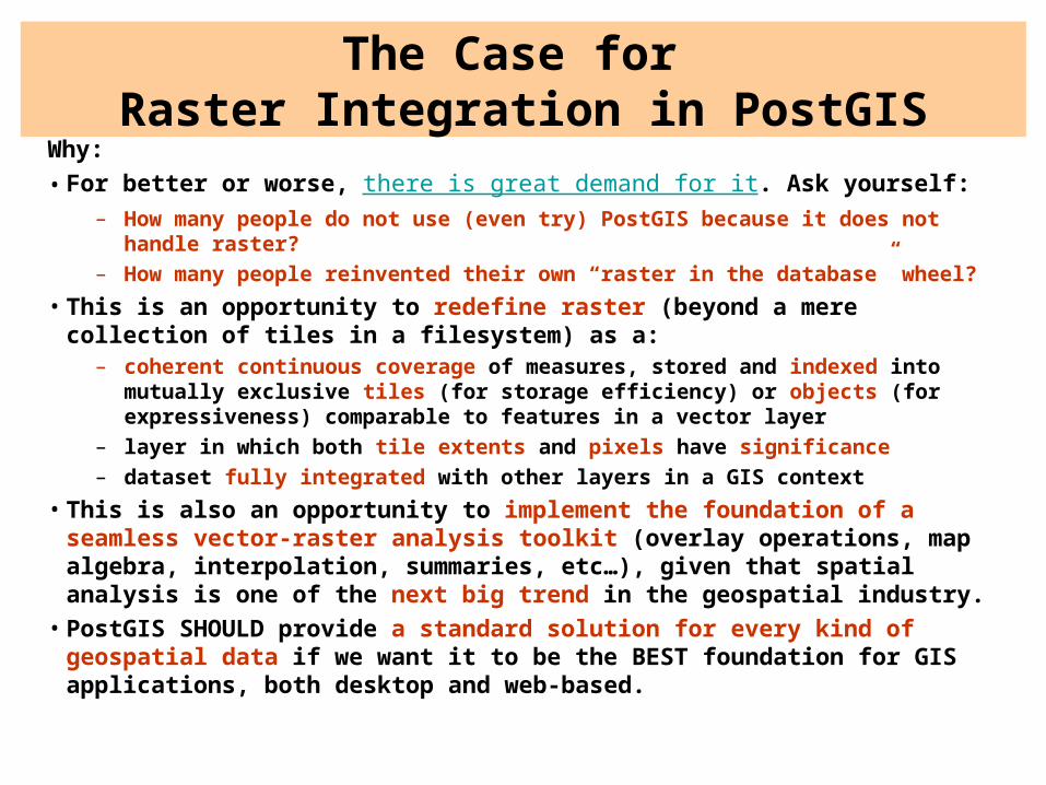
The Case for Raster Integration in PostGIS
Why:• For better or worse, there is great demand for it. Ask yourself:
– How many people do not use (even try) PostGIS because it does not handle raster?
– How many people reinvented their own “raster in the database” wheel?
• This is an opportunity to redefine raster (beyond a mere collection of tiles in a filesystem) as a:
– coherent continuous coverage of measures, stored and indexed into mutually exclusive tiles (for storage efficiency) or objects (for expressiveness) comparable to features in a vector layer
– layer in which both tile extents and pixels have significance– dataset fully integrated with other layers in a GIS context
• This is also an opportunity to implement the foundation of a seamless vector-raster analysis toolkit (overlay operations, map algebra, interpolation, summaries, etc…), given that spatial analysis is one of the next big trend in the geospatial industry.
• PostGIS SHOULD provide a standard solution for every kind of geospatial data if we want it to be the BEST foundation for GIS applications, both desktop and web-based.
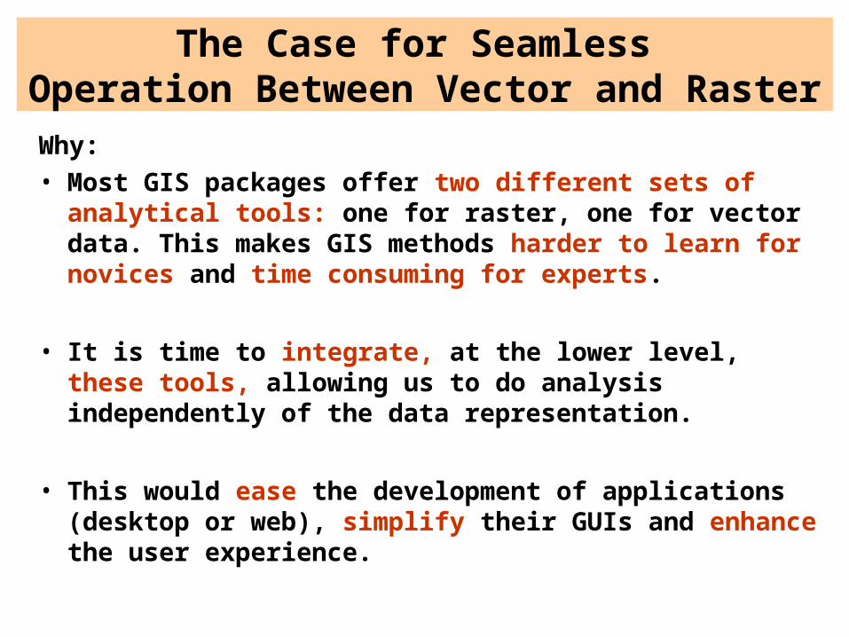
The Case for Seamless Operation Between Vector and Raster
Why:• Most GIS packages offer two different sets of analytical
tools: one for raster, one for vector data. This makes GIS methods harder to learn for novices and time consuming for experts.
• It is time to integrate, at the lower level, these tools, allowing us to do analysis independently of the data representation.
• This would ease the development of applications (desktop or web), simplify their GUIs and enhance the user experience.
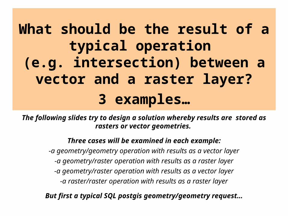
What should be the result of a typical operation
(e.g. intersection) between a vector and a raster layer?
3 examples…The following slides try to design a solution whereby results are stored
as rasters or vector geometries.
Three cases will be examined in each example:
-a geometry/geometry operation with results as a vector layer
-a geometry/raster operation with results as a raster layer
-a geometry/raster operation with results as a vector layer
-a raster/raster operation with results as a raster layer
But first a typical SQL postgis geometry/geometry request…
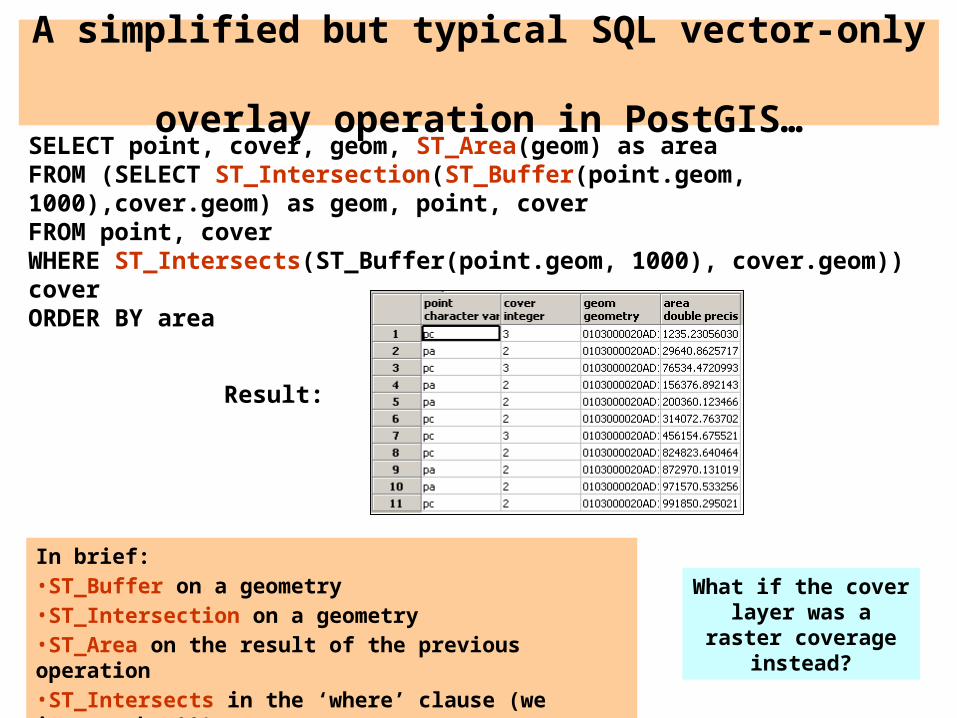
SELECT point, cover, geom, ST_Area(geom) as areaFROM (SELECT ST_Intersection(ST_Buffer(point.geom, 1000),cover.geom) as geom, point, cover FROM point, coverWHERE ST_Intersects(ST_Buffer(point.geom, 1000), cover.geom)) coverORDER BY area
In brief:•ST_Buffer on a geometry•ST_Intersection on a geometry•ST_Area on the result of the previous operation•ST_Intersects in the ‘where’ clause (we ignore the &&)
A simplified but typical SQL vector-only overlay operation in PostGIS…
Result:
What if the cover layer was a raster coverage instead?
Example 1
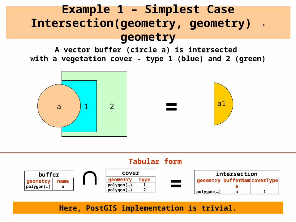
Example 1 – Simplest CaseIntersection(geometry, geometry) → geometry
1a a1
buffergeometry namepolygon(…) a
covergeometry typepolygon(…) 1polygon(…) 2
=intersection
geometry bufferName coverTypepolygon(…) a 1
=2
A vector buffer (circle a) is intersected with a vegetation cover - type 1 (blue) and 2 (green)
Here, PostGIS implementation is trivial.
Tabular form
r1 r2 r3 r4 r5
r6 r7 r8 r9 r10
r16 r17 r18 r19 r20
r21 r22 r23 r24 r25
r11 r12 r13 r14 r15
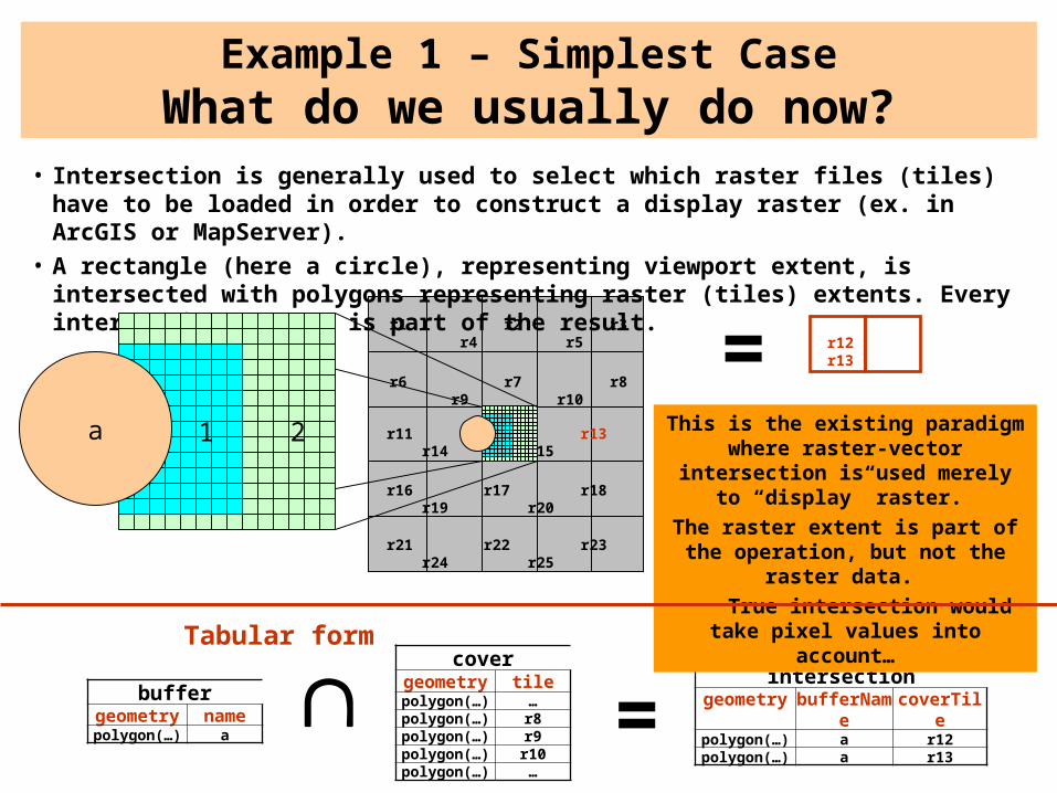
Example 1 – Simplest CaseWhat do we usually do now?
buffergeometry namepolygon(…) a
=intersection
geometry bufferName
coverTile
polygon(…) a r12polygon(…) a r13
=
covergeometry tilepolygon(…) …polygon(…) r8polygon(…) r9polygon(…) r10polygon(…) …
r12 r13
This is the existing paradigm where raster-vector intersection is used
merely to “display” raster.
The raster extent is part of the operation, but not the raster data.
True intersection would take pixel values into account…
• Intersection is generally used to select which raster files (tiles) have to be loaded in order to construct a display raster (ex. in ArcGIS or MapServer).
• A rectangle (here a circle), representing viewport extent, is intersected with polygons representing raster (tiles) extents. Every intersecting polygon is part of the result.
a 1 2
Tabular form

Example 1 – Simplest CaseIntersection(geometry,raster) → raster
buffergeometry namepolygon(…) a
coverraster
raster(2,2,2…1,1…2,2,2) =
2 2 2 2 2 2 2 2 2 2 2 2 2 22 2 2 2 2 2 2 2 2 2 2 2 2 21 1 1 1 1 1 1 1 2 2 2 2 2 21 1 1 1 1 1 1 1 2 2 2 2 2 21 1 1 1 1 1 1 1 2 2 2 2 2 21 1 1 1 1 1 1 1 2 2 2 2 2 21 1 1 1 1 1 1 1 2 2 2 2 2 21 1 1 1 1 1 1 1 2 2 2 2 2 21 1 1 1 1 1 1 1 2 2 2 2 2 21 1 1 1 1 1 1 1 2 2 2 2 2 21 1 1 1 1 1 1 1 2 2 2 2 2 21 1 1 1 1 1 1 1 2 2 2 2 2 21 1 1 1 1 1 1 1 2 2 2 2 2 22 2 2 2 2 2 2 2 2 2 2 2 2 2
0 0 0 0 0 0 0 0 0 0 0 0 0 00 0 0 0 0 0 0 0 0 0 0 0 0 00 0 0 0 0 0 0 0 0 0 0 0 0 01 1 0 0 0 0 0 0 0 0 0 0 0 01 1 1 1 0 0 0 0 0 0 0 0 0 01 1 1 1 0 0 0 0 0 0 0 0 0 01 1 1 1 0 0 0 0 0 0 0 0 0 01 1 1 1 0 0 0 0 0 0 0 0 0 01 1 1 1 0 0 0 0 0 0 0 0 0 01 1 1 1 0 0 0 0 0 0 0 0 0 01 1 1 0 0 0 0 0 0 0 0 0 0 01 1 0 0 0 0 0 0 0 0 0 0 0 00 0 0 0 0 0 0 0 0 0 0 0 0 00 0 0 0 0 0 0 0 0 0 0 0 0 0
a
1 1 0 01 1 1 01 1 1 11 1 1 11 1 1 11 1 1 11 1 1 11 1 1 01 1 0 0
or only
=
Q1 – What should be the extent of the result? Identical to the source raster, or to
the minimal significant area?
intersectionraster bufferName
raster(0,0,0,1,1…0) a
Tabular form
0 = nodata
Here the result is ALWAYS in raster form
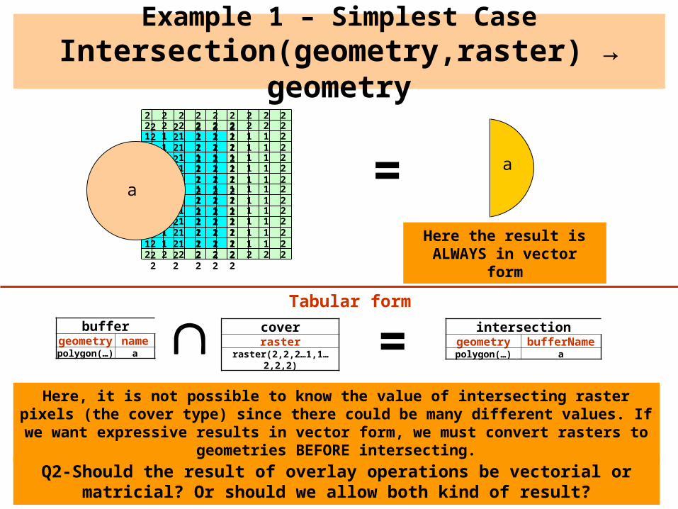
Example 1 – Simplest CaseIntersection(geometry,raster) → geometry
buffergeometry namepolygon(…) a
coverraster
raster(2,2,2…1,1…2,2,2) =
2 2 2 2 2 2 2 2 2 2 2 2 2 22 2 2 2 2 2 2 2 2 2 2 2 2 21 1 1 1 1 1 1 1 2 2 2 2 2 21 1 1 1 1 1 1 1 2 2 2 2 2 21 1 1 1 1 1 1 1 2 2 2 2 2 21 1 1 1 1 1 1 1 2 2 2 2 2 21 1 1 1 1 1 1 1 2 2 2 2 2 21 1 1 1 1 1 1 1 2 2 2 2 2 21 1 1 1 1 1 1 1 2 2 2 2 2 21 1 1 1 1 1 1 1 2 2 2 2 2 21 1 1 1 1 1 1 1 2 2 2 2 2 21 1 1 1 1 1 1 1 2 2 2 2 2 21 1 1 1 1 1 1 1 2 2 2 2 2 22 2 2 2 2 2 2 2 2 2 2 2 2 2
a
a
intersectiongeometry bufferNamepolygon(…) a
=Here the result is
ALWAYS in vector form
Q2-Should the result of overlay operations be vectorial or matricial? Or should we allow both kind of result?
Tabular form
Here, it is not possible to know the value of intersecting raster pixels (the cover type) since there could be many different values. If we want expressive results in vector form,
we must convert rasters to geometries BEFORE intersecting.
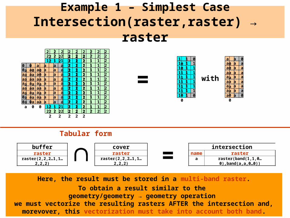
Example 1 – Simplest CaseIntersection(raster,raster) → raster
bufferraster
raster(2,2,2…1,1…2,2,2)
coverraster
raster(2,2,2…1,1…2,2,2) =
2 2 2 2 2 2 2 2 2 2 2 2 2 22 2 2 2 2 2 2 2 2 2 2 2 2 21 1 1 1 1 1 1 1 2 2 2 2 2 21 1 1 1 1 1 1 1 2 2 2 2 2 21 1 1 1 1 1 1 1 2 2 2 2 2 21 1 1 1 1 1 1 1 2 2 2 2 2 21 1 1 1 1 1 1 1 2 2 2 2 2 21 1 1 1 1 1 1 1 2 2 2 2 2 21 1 1 1 1 1 1 1 2 2 2 2 2 21 1 1 1 1 1 1 1 2 2 2 2 2 21 1 1 1 1 1 1 1 2 2 2 2 2 21 1 1 1 1 1 1 1 2 2 2 2 2 21 1 1 1 1 1 1 1 2 2 2 2 2 22 2 2 2 2 2 2 2 2 2 2 2 2 2
1 1 0 01 1 1 01 1 1 11 1 1 11 1 1 11 1 1 11 1 1 11 1 1 01 1 0 0
with=
intersectionname raster
a raster(band(1,1,0…0),band(a,a,0…0))
Tabular form
a a 0 0a a a 0a a a aa a a aa a a aa a a aa a a aa a a 0a a 0 0
0 0 a a a a a 0 00 a a a a a a a 0a a a a a a a a aa a a a a a a a aa a a a a a a a aa a a a a a a a aa a a a a a a a a0 a a a a a a a a0 0 a a a a a 0 0
Here, the result must be stored in a multi-band raster.
To obtain a result similar to the geometry/geometry → geometry operation
we must vectorize the resulting rasters AFTER the intersection and, morevover, this vectorization must take into account both band.

Example 2
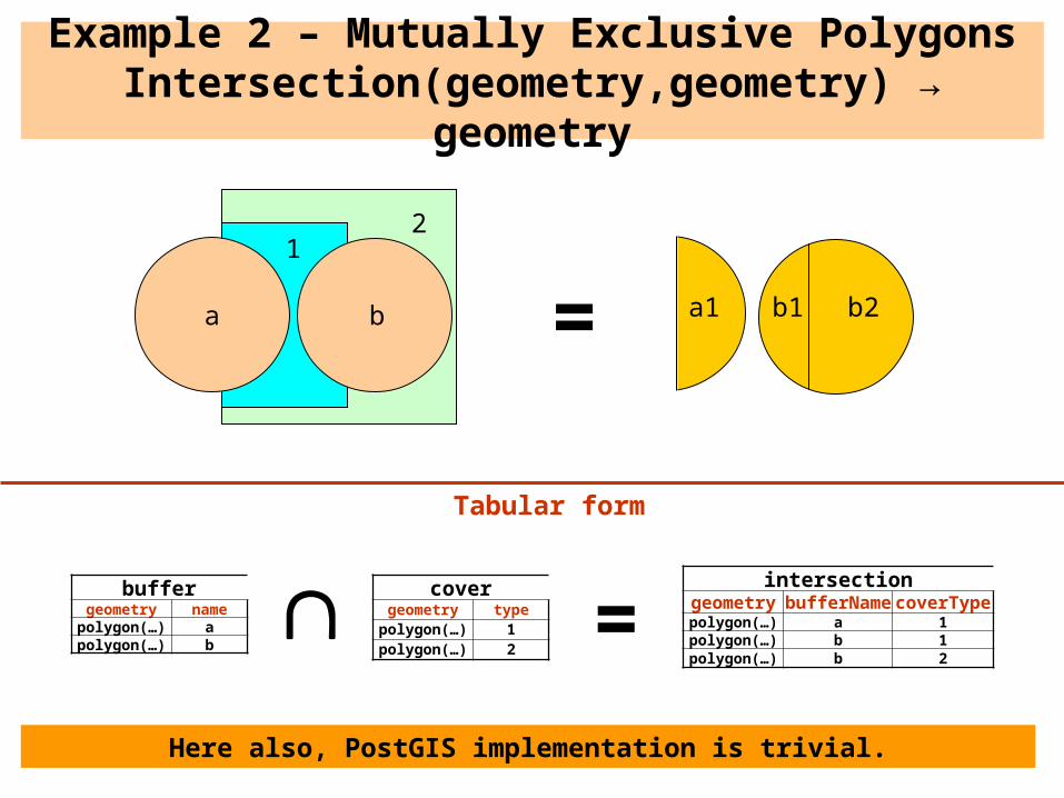
Example 2 – Mutually Exclusive PolygonsIntersection(geometry,geometry) → geometry
1
a
buffergeometry name
polygon(…) apolygon(…) b
covergeometry type
polygon(…) 1polygon(…) 2
=intersection
geometry bufferName coverTypepolygon(…) a 1polygon(…) b 1polygon(…) b 2
b
2
a1 b1 b2=
Here also, PostGIS implementation is trivial.
Tabular form
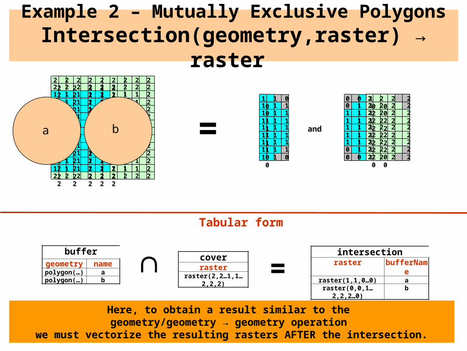
Example 2 – Mutually Exclusive PolygonsIntersection(geometry,raster) → raster
buffergeometry namepolygon(…) apolygon(…) b
coverraster
raster(2,2…1,1…2,2,2) =
2 2 2 2 2 2 2 2 2 2 2 2 2 22 2 2 2 2 2 2 2 2 2 2 2 2 21 1 1 1 1 1 1 1 2 2 2 2 2 21 1 1 1 1 1 1 1 2 2 2 2 2 21 1 1 1 1 1 1 1 2 2 2 2 2 21 1 1 1 1 1 1 1 2 2 2 2 2 21 1 1 1 1 1 1 1 2 2 2 2 2 21 1 1 1 1 1 1 1 2 2 2 2 2 21 1 1 1 1 1 1 1 2 2 2 2 2 21 1 1 1 1 1 1 1 2 2 2 2 2 21 1 1 1 1 1 1 1 2 2 2 2 2 21 1 1 1 1 1 1 1 2 2 2 2 2 21 1 1 1 1 1 1 1 2 2 2 2 2 22 2 2 2 2 2 2 2 2 2 2 2 2 2
a =b
1 1 0 01 1 1 01 1 1 11 1 1 11 1 1 11 1 1 11 1 1 11 1 1 01 1 0 0
2 2 2 2 0 02 2 2 2 2 02 2 2 2 2 22 2 2 2 2 22 2 2 2 2 22 2 2 2 2 22 2 2 2 2 22 2 2 2 2 02 2 2 2 0 0
0 0 10 1 11 1 11 1 11 1 11 1 11 1 10 1 10 0 1
intersectionraster bufferName
raster(1,1,0…0) araster(0,0,1…2,2,2…0) b
Tabular form
and
Here, to obtain a result similar to the geometry/geometry → geometry operation
we must vectorize the resulting rasters AFTER the intersection.
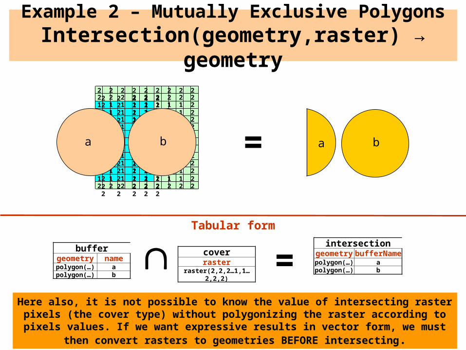
Example 2 – Mutually Exclusive PolygonsIntersection(geometry,raster) → geometry
buffergeometry namepolygon(…) apolygon(…) b
coverraster
raster(2,2,2…1,1…2,2,2) =
2 2 2 2 2 2 2 2 2 2 2 2 2 22 2 2 2 2 2 2 2 2 2 2 2 2 21 1 1 1 1 1 1 1 2 2 2 2 2 21 1 1 1 1 1 1 1 2 2 2 2 2 21 1 1 1 1 1 1 1 2 2 2 2 2 21 1 1 1 1 1 1 1 2 2 2 2 2 21 1 1 1 1 1 1 1 2 2 2 2 2 21 1 1 1 1 1 1 1 2 2 2 2 2 21 1 1 1 1 1 1 1 2 2 2 2 2 21 1 1 1 1 1 1 1 2 2 2 2 2 21 1 1 1 1 1 1 1 2 2 2 2 2 21 1 1 1 1 1 1 1 2 2 2 2 2 21 1 1 1 1 1 1 1 2 2 2 2 2 22 2 2 2 2 2 2 2 2 2 2 2 2 2
a
intersectiongeometry bufferNamepolygon(…) apolygon(…) b
b a b=
Tabular form
Here also, it is not possible to know the value of intersecting raster pixels (the cover type) without polygonizing the raster according to pixels values. If we want expressive results
in vector form, we must then convert rasters to geometries BEFORE intersecting.
2 2 2 2 2 2 2 2 2 2 2 2 2 22 2 2 2 2 2 2 2 2 2 2 2 2 21 1 1 1 1 1 1 1 2 2 2 2 2 21 1 1 1 1 1 1 1 2 2 2 2 2 21 1 1 1 1 1 1 1 2 2 2 2 2 21 1 1 1 1 1 1 1 2 2 2 2 2 21 1 1 1 1 1 1 1 2 2 2 2 2 21 1 1 1 1 1 1 1 2 2 2 2 2 21 1 1 1 1 1 1 1 2 2 2 2 2 21 1 1 1 1 1 1 1 2 2 2 2 2 21 1 1 1 1 1 1 1 2 2 2 2 2 21 1 1 1 1 1 1 1 2 2 2 2 2 21 1 1 1 1 1 1 1 2 2 2 2 2 22 2 2 2 2 2 2 2 2 2 2 2 2 2
0 0 a a a a a 0 00 a a a a a a a 0a a a a a a a a aa a a a a a a a aa a a a a a a a aa a a a a a a a aa a a a a a a a a0 a a a a a a a a0 0 a a a a a 0 0
0 0 b b b b b 0 00 b b b b b b b 0b b b b b b b b bb b b b b b b b bb b b b b b b b bb b b b b b b b bb b b b b b b b b0 b b b b b b b b0 0 b b b b b 0 0
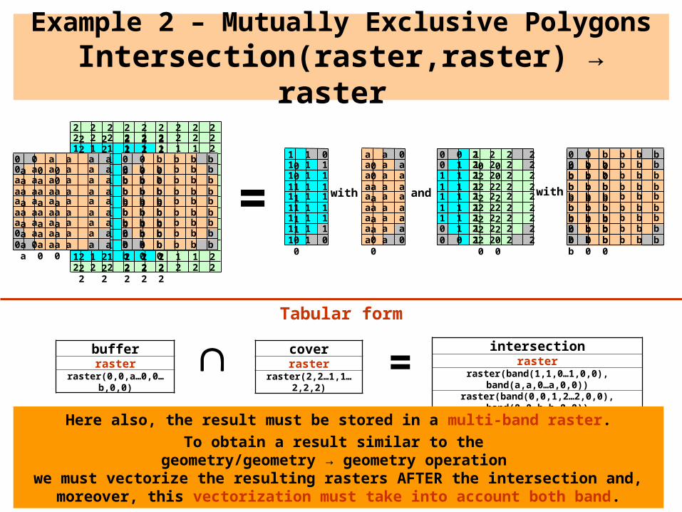
Example 2 – Mutually Exclusive PolygonsIntersection(raster,raster) → raster
coverraster
raster(2,2…1,1…2,2,2) =
= with
1 1 0 01 1 1 01 1 1 11 1 1 11 1 1 11 1 1 11 1 1 11 1 1 01 1 0 0
a a 0 0a a a 0a a a aa a a aa a a aa a a aa a a aa a a 0a a 0 0
0 0 b b b b b 0 00 b b b b b b b 0b b b b b b b b bb b b b b b b b bb b b b b b b b bb b b b b b b b bb b b b b b b b b0 b b b b b b b b0 0 b b b b b 0 0
2 2 2 2 0 02 2 2 2 2 02 2 2 2 2 22 2 2 2 2 22 2 2 2 2 22 2 2 2 2 22 2 2 2 2 22 2 2 2 2 02 2 2 2 0 0
0 0 10 1 11 1 11 1 11 1 11 1 11 1 10 1 10 0 1
intersectionraster
raster(band(1,1,0…1,0,0), band(a,a,0…a,0,0))raster(band(0,0,1,2…2,0,0), band(0,0,b…b,0,0))
bufferraster
raster(0,0,a…0,0…b,0,0)
Here also, the result must be stored in a multi-band raster.
To obtain a result similar to the geometry/geometry → geometry operation
we must vectorize the resulting rasters AFTER the intersection and, moreover, this vectorization must take into account both band.
Tabular form
and with

Example 3
a2
Example 3 – Non-Mutually Exclusive Polygons
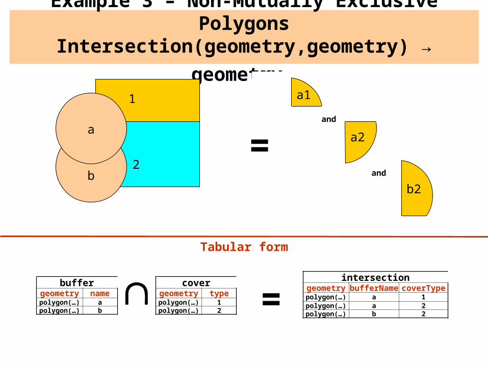
Intersection(geometry,geometry) → geometry
2
1
a
b
a1
b2
buffergeometry namepolygon(…) apolygon(…) b
covergeometry typepolygon(…) 1polygon(…) 2
=intersection
geometry bufferName coverTypepolygon(…) a 1polygon(…) a 2polygon(…) b 2
Tabular form
=and
and

coverraster
raster(1,1…2,2,2)
=
1 1 1 1 1 1 1 1 1 1 1 1 1 11 1 1 1 1 1 1 1 1 1 1 1 1 11 1 1 1 1 1 1 1 1 1 1 1 1 11 1 1 1 1 1 1 1 1 1 1 1 1 11 1 1 1 1 1 1 1 1 1 1 1 1 11 1 1 1 1 1 1 1 1 1 1 1 1 12 2 2 2 2 2 2 2 2 2 2 2 2 22 2 2 2 2 2 2 2 2 2 2 2 2 22 2 2 2 2 2 2 2 2 2 2 2 2 22 2 2 2 2 2 2 2 2 2 2 2 2 22 2 2 2 2 2 2 2 2 2 2 2 2 22 2 2 2 2 2 2 2 2 2 2 2 2 22 2 2 2 2 2 2 2 2 2 2 2 2 22 2 2 2 2 2 2 2 2 2 2 2 2 2
a
b
buffergeometry namepolygon(…) apolygon(…) b
=intersection
raster bufferNameraster(1,1,0…2,2…0) a
raster(2,0…2,0) b
1 0 0 01 1 0 01 1 1 01 1 1 12 2 2 22 2 2 2
2 2 2 02 2 0 0
2 2 2 02 0 0 02 2 0 02 2 2 02 2 2 02 2 2 22 2 2 22 2 2 0
Tabular form
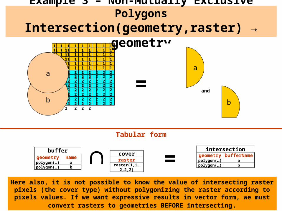
Example 3 – Non-Mutually Exclusive PolygonsIntersection(geometry,raster) → raster
Here also, to obtain a result similar to the geometry/geometry → geometry operation
we must vectorize the resulting rasters AFTER the intersection.
and
coverraster
raster(1,1…2,2,2)
1 1 1 1 1 1 1 1 1 1 1 1 1 11 1 1 1 1 1 1 1 1 1 1 1 1 11 1 1 1 1 1 1 1 1 1 1 1 1 11 1 1 1 1 1 1 1 1 1 1 1 1 11 1 1 1 1 1 1 1 1 1 1 1 1 11 1 1 1 1 1 1 1 1 1 1 1 1 12 2 2 2 2 2 2 2 2 2 2 2 2 22 2 2 2 2 2 2 2 2 2 2 2 2 22 2 2 2 2 2 2 2 2 2 2 2 2 22 2 2 2 2 2 2 2 2 2 2 2 2 22 2 2 2 2 2 2 2 2 2 2 2 2 22 2 2 2 2 2 2 2 2 2 2 2 2 22 2 2 2 2 2 2 2 2 2 2 2 2 22 2 2 2 2 2 2 2 2 2 2 2 2 2
a
b
buffergeometry namepolygon(…) apolygon(…) b
=Tabular form
Example 3 – Non-Mutually Exclusive PolygonsIntersection(geometry,raster) → geometry
b
=
intersectiongeometry bufferNamepolygon(…) apolygon(…) b
Here also, it is not possible to know the value of intersecting raster pixels (the cover type) without polygonizing the raster according to pixels values. If we want expressive results
in vector form, we must convert rasters to geometries BEFORE intersecting.
and
a
covergeometry
raster(1,1…2,2,2)
=
1 1 1 1 1 1 1 1 1 1 1 1 1 11 1 1 1 1 1 1 1 1 1 1 1 1 11 1 1 1 1 1 1 1 1 1 1 1 1 11 1 1 1 1 1 1 1 1 1 1 1 1 11 1 1 1 1 1 1 1 1 1 1 1 1 11 1 1 1 1 1 1 1 1 1 1 1 1 12 2 2 2 2 2 2 2 2 2 2 2 2 22 2 2 2 2 2 2 2 2 2 2 2 2 22 2 2 2 2 2 2 2 2 2 2 2 2 22 2 2 2 2 2 2 2 2 2 2 2 2 22 2 2 2 2 2 2 2 2 2 2 2 2 22 2 2 2 2 2 2 2 2 2 2 2 2 22 2 2 2 2 2 2 2 2 2 2 2 2 22 2 2 2 2 2 2 2 2 2 2 2 2 2
=
1 0 0 01 1 0 01 1 1 01 1 1 12 2 2 22 2 2 2
2 2 2 02 2 0 0
2 2 2 0
2 0 0 02 2 0 02 2 2 02 2 2 02 2 2 22 2 2 22 2 2 0
Tabular form
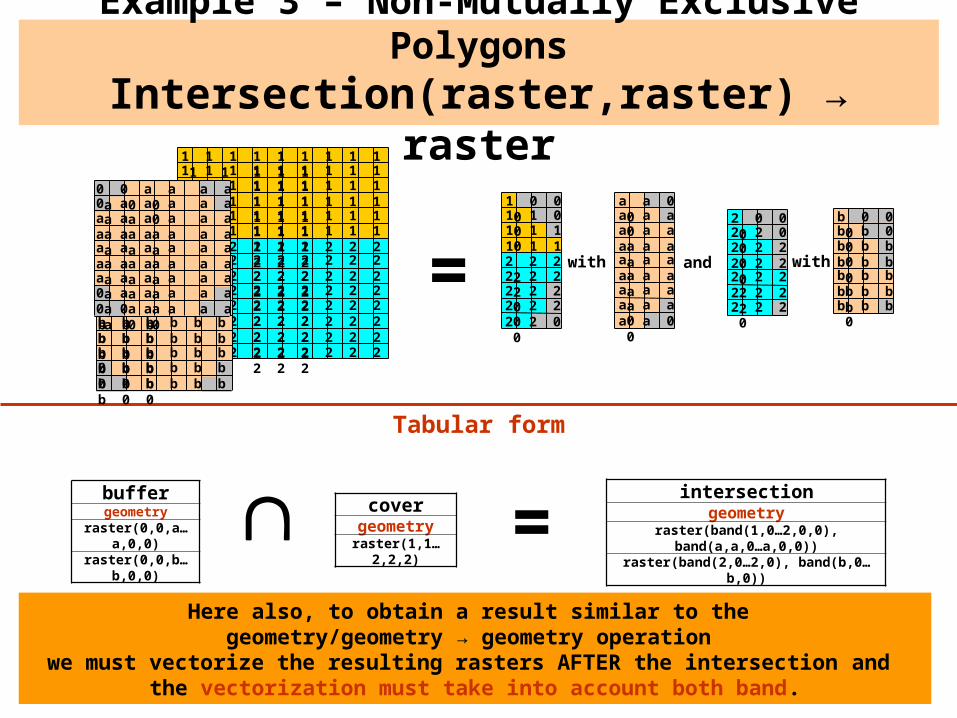
Example 3 – Non-Mutually Exclusive PolygonsIntersection(raster,raster) → raster
Here also, to obtain a result similar to the geometry/geometry → geometry operation
we must vectorize the resulting rasters AFTER the intersection and the vectorization must take into account both band.
and0 0 b b b b b 0 00 b b b b b b b 0b b b b b b b b bb b b b b b b b bb b b b b b b b bb b b b b b b b bb b b b b b b b b0 b b b b b b b b0 0 b b b b b 0 0
0 0 a a a a a 0 00 a a a a a a a 0a a a a a a a a aa a a a a a a a aa a a a a a a a aa a a a a a a a aa a a a a a a a a0 a a a a a a a a0 0 a a a a a 0 0
a a 0 0a a a 0a a a aa a a aa a a aa a a aa a a aa a a 0a a 0 0
with
b 0 0 0b b 0 0b b b 0b b b 0b b b bb b b bb b b 0
with
intersectiongeometry
raster(band(1,0…2,0,0), band(a,a,0…a,0,0))raster(band(2,0…2,0), band(b,0…b,0))
buffergeometry
raster(0,0,a…a,0,0)raster(0,0,b…b,0,0)
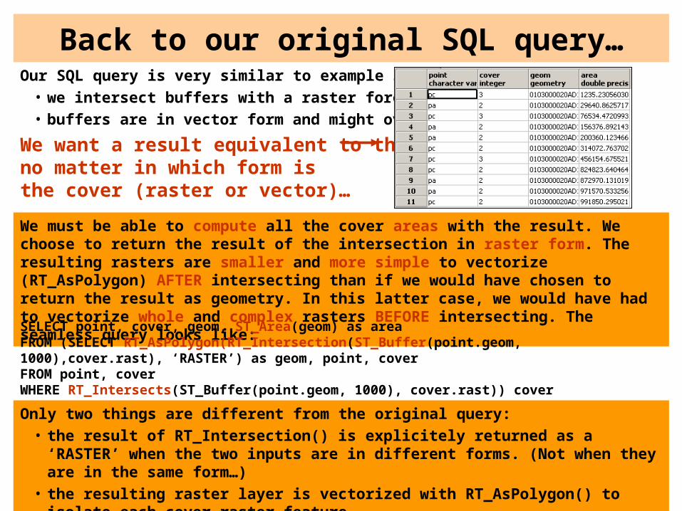
Back to our original SQL query…Our SQL query is very similar to example 3:
• we intersect buffers with a raster forest cover;• buffers are in vector form and might overlap;
We want a result equivalent to this: no matter in which form isthe cover (raster or vector)…
We must be able to compute all the cover areas with the result. We choose to return the result of the intersection in raster form. The resulting rasters are smaller and more simple to vectorize (RT_AsPolygon) AFTER intersecting than if we would have chosen to return the result as geometry. In this latter case, we would have had to vectorize whole and complex rasters BEFORE intersecting. The seamless query looks like:
SELECT point, cover, geom, ST_Area(geom) as areaFROM (SELECT RT_AsPolygon(RT_Intersection(ST_Buffer(point.geom, 1000),cover.rast), ‘RASTER’) as geom, point, cover FROM point, coverWHERE RT_Intersects(ST_Buffer(point.geom, 1000), cover.rast)) cover
Only two things are different from the original query:• the result of RT_Intersection() is explicitely returned as a ‘RASTER’ when the two
inputs are in different forms. (Not when they are in the same form…)• the resulting raster layer is vectorized with RT_AsPolygon() to isolate each cover
raster feature.

Specifications, Open Questions, and Some Query Examples
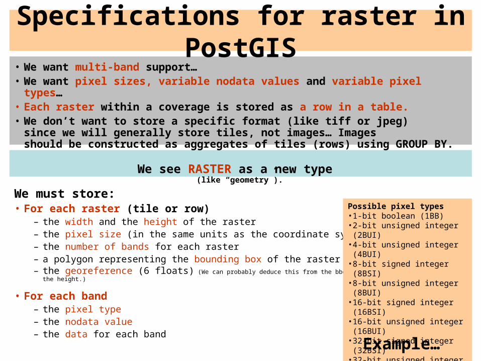
Specifications for raster in PostGIS• We want multi-band support…• We want pixel sizes, variable nodata values and variable pixel types…• Each raster within a coverage is stored as a row in a table. • We don’t want to store a specific format (like tiff or jpeg)
since we will generally store tiles, not images… Images should be constructed as aggregates of tiles (rows) using GROUP BY.
We see RASTER as a new type(like “geometry”).
We must store:• For each raster (tile or row)
– the width and the height of the raster– the pixel size (in the same units as the coordinate system)– the number of bands for each raster– a polygon representing the bounding box of the raster– the georeference (6 floats) (We can probably deduce this from the bbox polygon, the width and
the height.)
• For each band – the pixel type– the nodata value– the data for each band
Possible pixel types• 1-bit boolean (1BB)• 2-bit unsigned integer (2BUI)• 4-bit unsigned integer (4BUI)• 8-bit signed integer (8BSI)• 8-bit unsigned integer (8BUI)• 16-bit signed integer (16BSI)• 16-bit unsigned integer (16BUI)• 32-bit signed integer (32BSI)• 32-bit unsigned integer (32BUI)• 16-bit float (16BF)• 32-bit float (32BF)• 64-bit float (64BF)
Example…

RT_RasterFromText(‘RASTER(2,8,30.0,2,22165.382558570,785,0,0,-22165.382558570815,-545856.650,7086694.1733, BAND(8BUI,(0,3,7,6,8,9,1,8,9,5,5,6,6,2,2,4,4)),BAND(16BF,(0.0,1.2,1.2,2.6,2.6,3.4,3.4,4.0,4.0,5.6,5.6,6.3,6.3,7.8,7.8,8.6,8.6)))’,[<srid>])
Example of WKT raster
width, heightAffine
transform
1st and 2nd band values
1.2 1.2
2.6 2.6
3.4 3.4
4.0 4.0
5.6 5.6
6.3 6.3
7.8 7.8
8.6 8.6
3 76 89 18 95 56 62 24 4
2 band raster
cover precipitation
Creation of a 2x8 raster with 2 bands (8-bit signed integer and 16-bit float) similar to ST_GeomFromText(text,[<srid>])
• WKB form stores data compressed as deflate
pixel sizenumber of band
pixel type for 1st band and 2nd band
nodata value for 1st band and 2nd band
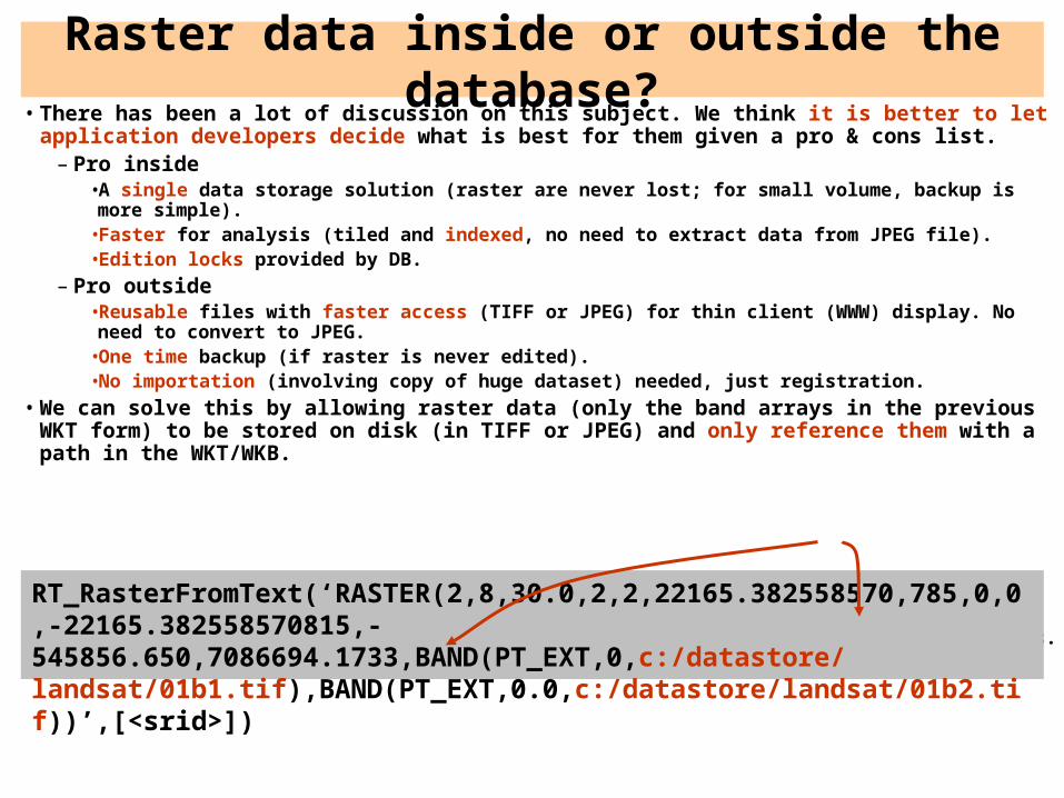
Raster data inside or outside the database?• There has been a lot of discussion on this subject. We think it is better to let application
developers decide what is best for them given a pro & cons list.– Pro inside
•A single data storage solution (raster are never lost; for small volume, backup is more simple).•Faster for analysis (tiled and indexed, no need to extract data from JPEG file).•Edition locks provided by DB.
– Pro outside•Reusable files with faster access (TIFF or JPEG) for thin client (WWW) display. No need to convert to JPEG.
•One time backup (if raster is never edited).•No importation (involving copy of huge dataset) needed, just registration.
• We can solve this by allowing raster data (only the band arrays in the previous WKT form) to be stored on disk (in TIFF or JPEG) and only reference them with a path in the WKT/WKB.
• Every function listed below work seamlessly wherever the raster is stored.• Add RT_GetPath(raster, band) to know the name of the raster file.• Add –R option to the importer so no data are copied to the DB, only reference to the files.
RT_RasterFromText(‘RASTER(2,8,30.0,2,2,22165.382558570,785,0,0,-22165.382558570815,-545856.650,7086694.1733,BAND(PT_EXT,0,c:/datastore/ landsat/01b1.tif),BAND(PT_EXT,0.0,c:/datastore/landsat/01b2.tif))’,[<srid>])
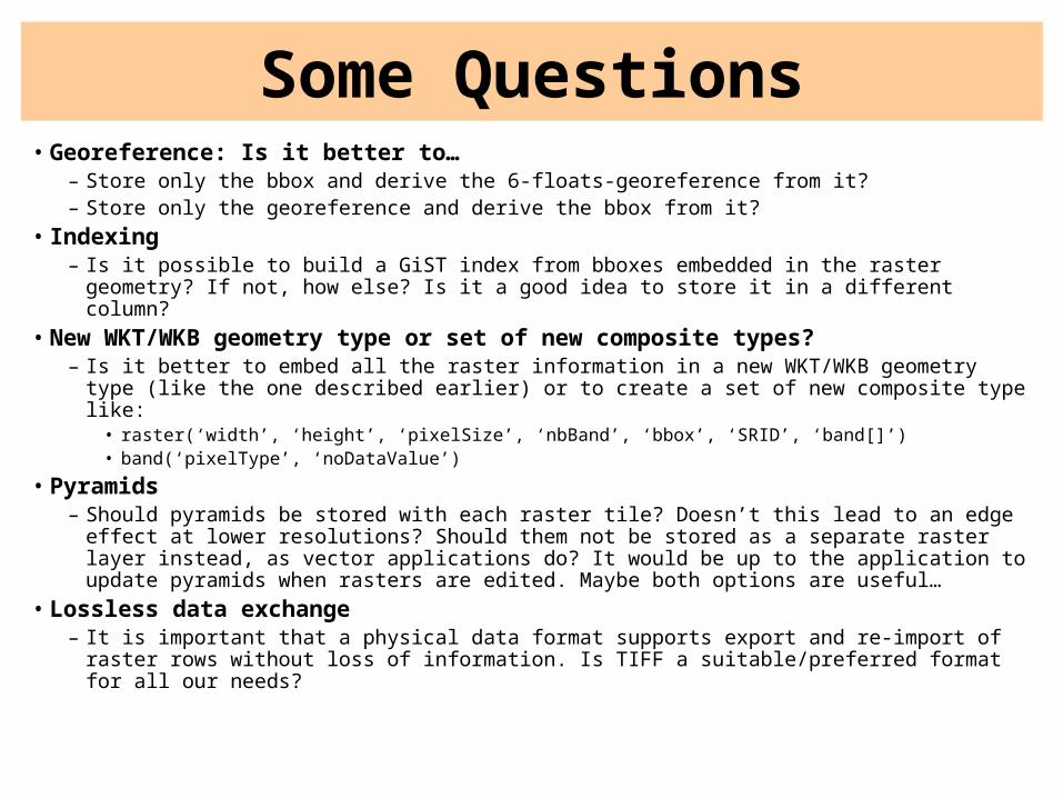
Some Questions• Georeference: Is it better to…
– Store only the bbox and derive the 6-floats-georeference from it?– Store only the georeference and derive the bbox from it?
• Indexing– Is it possible to build a GiST index from bboxes embedded in the raster geometry? If not,
how else? Is it a good idea to store it in a different column?
• New WKT/WKB geometry type or set of new composite types?– Is it better to embed all the raster information in a new WKT/WKB geometry type (like the
one described earlier) or to create a set of new composite type like:• raster(‘width’, ‘height’, ‘pixelSize’, ‘nbBand’, ‘bbox’, ‘SRID’, ‘band[]’)• band(‘pixelType’, ‘noDataValue’)
• Pyramids– Should pyramids be stored with each raster tile? Doesn’t this lead to an edge effect at
lower resolutions? Should them not be stored as a separate raster layer instead, as vector applications do? It would be up to the application to update pyramids when rasters are edited. Maybe both options are useful…
• Lossless data exchange– It is important that a physical data format supports export and re-import of raster rows
without loss of information. Is TIFF a suitable/preferred format for all our needs?
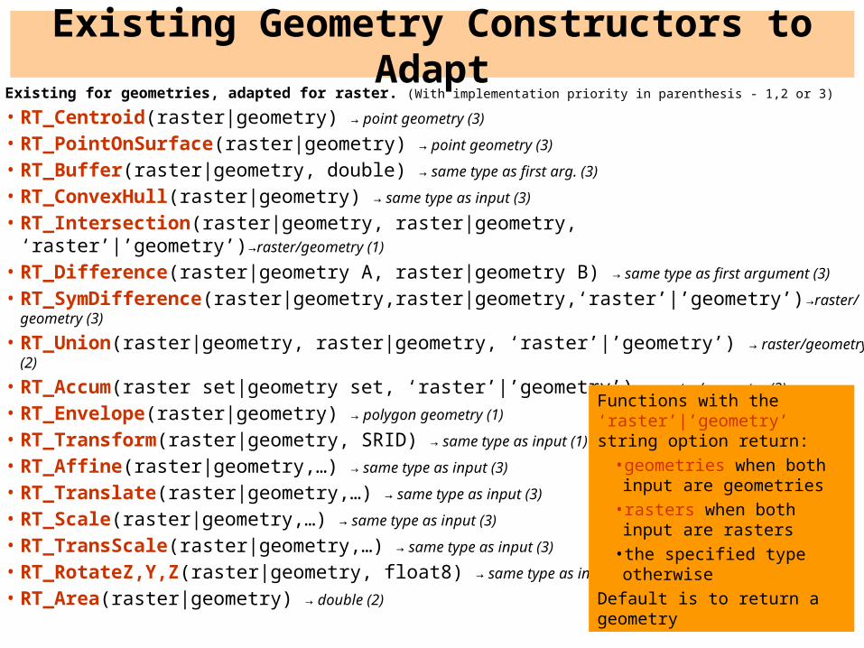
Existing Geometry Constructors to AdaptExisting for geometries, adapted for raster. (With implementation priority in parenthesis - 1,2 or 3)
• RT_Centroid(raster|geometry) → point geometry (3)
• RT_PointOnSurface(raster|geometry) → point geometry (3)
• RT_Buffer(raster|geometry, double) → same type as first arg. (3)
• RT_ConvexHull(raster|geometry) → same type as input (3)
• RT_Intersection(raster|geometry, raster|geometry, ‘raster’|’geometry’)→raster/geometry (1)
• RT_Difference(raster|geometry A, raster|geometry B) → same type as first argument (3)
• RT_SymDifference(raster|geometry,raster|geometry,‘raster’|’geometry’)→raster/geometry (3)
• RT_Union(raster|geometry, raster|geometry, ‘raster’|’geometry’) → raster/geometry (2)
• RT_Accum(raster set|geometry set, ‘raster’|’geometry’) → raster/geometry (2)
• RT_Envelope(raster|geometry) → polygon geometry (1)
• RT_Transform(raster|geometry, SRID) → same type as input (1)
• RT_Affine(raster|geometry,…) → same type as input (3)
• RT_Translate(raster|geometry,…) → same type as input (3)
• RT_Scale(raster|geometry,…) → same type as input (3)
• RT_TransScale(raster|geometry,…) → same type as input (3)
• RT_RotateZ,Y,Z(raster|geometry, float8) → same type as input (3)
• RT_Area(raster|geometry) → double (2)
Functions with the ‘raster’|’geometry’ string option return:
• geometries when both input are geometries
• rasters when both input are rasters
• the specified type otherwise
Default is to return a geometry
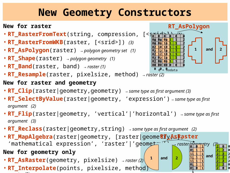
New for raster • RT_RasterFromText(string, compression, [<srid>]) (1)
• RT_RasterFromWKB(raster, [<srid>]) (3)
• RT_AsPolygon(raster) → polygon geometry set (1)
• RT_Shape(raster) → polygon geometry (1)
• RT_Band(raster, band) → raster (1)
• RT_Resample(raster, pixelsize, method) → raster (2)
New for raster and geometry• RT_Clip(raster|geometry,geometry) → same type as first argument (3)
• RT_SelectByValue(raster|geometry, ‘expression’) → same type as first argument (2)
• RT_Flip(raster|geometry, ’vertical’|’horizontal’) → same type as first argument (3)
• RT_Reclass(raster|geometry,string) → same type as first argument (2)
• RT_MapAlgebra(raster|geometry, [raster|geometry,…], ‘mathematical expression’, ‘raster’|’geometry’) → raster/geometry (3)
New for geometry only• RT_AsRaster(geometry, pixelsize) → raster (2)
• RT_Interpolate(points, pixelsize, method) → raster (3)
New Geometry Constructors
0 0 0 0 0 0 0 0 00 0 0 1 1 2 0 0 00 0 1 1 1 2 2 0 00 1 1 1 1 2 2 2 00 1 1 1 1 2 2 2 00 1 1 1 1 2 2 2 00 0 1 1 1 2 2 0 00 0 0 1 1 2 0 0 00 0 0 0 0 0 0 0 0
RT_AsPolygon
and1 2
0 = nodata
RT_AsRaster
0 0 1 10 1 1 11 1 1 11 1 1 11 1 1 10 1 1 10 0 1 1
2 0 02 2 02 2 22 2 22 2 22 2 02 0 0
and1 2and
0 0 0 0 0 0 0 0 00 0 0 1 1 2 0 0 00 0 1 1 1 2 2 0 00 1 1 1 1 2 2 2 00 1 1 1 1 2 2 2 00 1 1 1 1 2 2 2 00 0 1 1 1 2 2 0 00 0 0 1 1 2 0 0 00 0 0 0 0 0 0 0 0
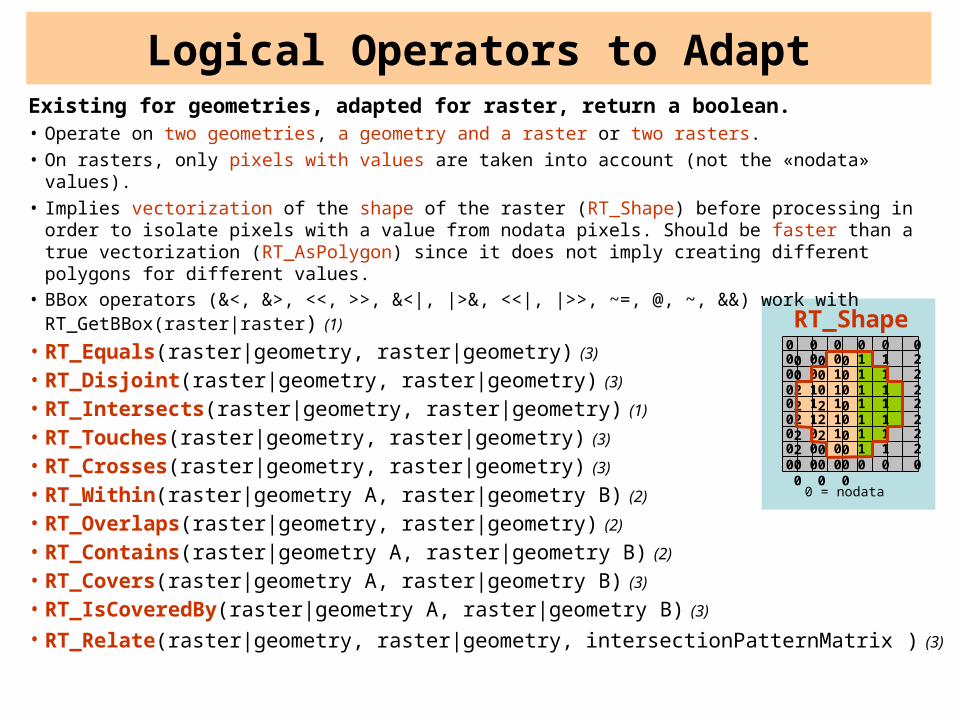
Logical Operators to AdaptExisting for geometries, adapted for raster, return a boolean.• Operate on two geometries, a geometry and a raster or two rasters.• On rasters, only pixels with values are taken into account (not the «nodata» values).• Implies vectorization of the shape of the raster (RT_Shape) before processing in order to
isolate pixels with a value from nodata pixels. Should be faster than a true vectorization (RT_AsPolygon) since it does not imply creating different polygons for different values.
• BBox operators (&<, &>, <<, >>, &<|, |>&, <<|, |>>, ~=, @, ~, &&) work with RT_GetBBox(raster|raster) (1)
• RT_Equals(raster|geometry, raster|geometry) (3)
• RT_Disjoint(raster|geometry, raster|geometry) (3)
• RT_Intersects(raster|geometry, raster|geometry) (1)
• RT_Touches(raster|geometry, raster|geometry) (3)
• RT_Crosses(raster|geometry, raster|geometry) (3)
• RT_Within(raster|geometry A, raster|geometry B) (2)
• RT_Overlaps(raster|geometry, raster|geometry) (2)
• RT_Contains(raster|geometry A, raster|geometry B) (2)
• RT_Covers(raster|geometry A, raster|geometry B) (3)
• RT_IsCoveredBy(raster|geometry A, raster|geometry B) (3)
• RT_Relate(raster|geometry, raster|geometry, intersectionPatternMatrix ) (3)
0 = nodata
RT_Shape

Existing and New AccessorsExisting for geometries, adapted for raster • RT_AsText(raster|geometry) (1)
• RT_AsBinary(raster, compression) (2)
• RT_AsKML(raster|geometry) → KML (3)
• RT_AsSVG(raster|geometry) → SVG (3)
• RT_SRID(raster|geometry) → integer (1)
• RT_SetSRID(raster|geometry, integer) (1)
• RT_IsEmpty(raster|geometry) → boolean (2)
• RT_mem_size(raster|geometry) → integer (2)
• RT_isvalid(raster|geometry) → boolean (2)
• RT_GetNumBands(raster) → integer (1)
• RT_GetNoDataValue(raster, band) → string (1)
• RT_SetNoDataValue(raster, band, value) (1)
• RT_GetMaximumValue(raster, band) → pixeltype (1)
• RT_GetMinimumValue(raster, band) → pixeltype (1)
• RT_Count(raster, value) → integer (2)
• RT_GetGeoReference(raster) → string (1)
• RT_SetGeoReference(raster, string) (1)
• RT_SetValue(raster, band, x, y, value) (3)
New for raster• RT_AsJPEG(raster, quality) → jpeg (2)
• RT_AsTIFF(raster, compression) → TIFF (2)
• RT_GetWidth(raster) → integer (1)
• RT_GetHeight(raster) → integer (1)
• RT_GetPixelType(raster, band) → string (1)
• RT_SetPixelType(raster, band, string) → string (1?)
• RT_GetPixelSize(raster) → integer (1)
• RT_SetPixelSize(raster) → integer (1?)
• RT_GetBBox(raster) → polygon geometry (1)
RT_GetBBox
RT_Envelope
0 = nodata
0 0 0 0 0 0 0 0 0
0 0 0 1 1 2 0 0 0
0 0 1 1 1 2 2 0 0
0 1 1 1 1 2 2 2 0
0 1 1 1 1 2 2 2 0
0 1 1 1 1 2 2 2 0
0 0 1 1 1 2 2 0 0
0 0 0 1 1 2 0 0 0
0 0 0 0 0 0 0 0 0
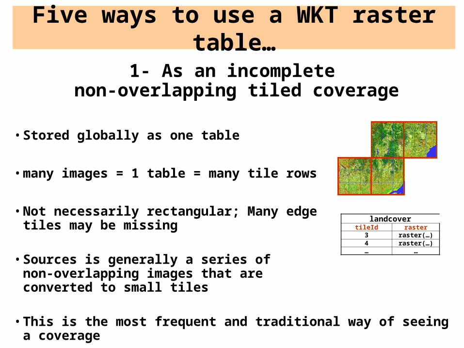
Five ways to use a WKT raster table…
1- As an incompletenon-overlapping tiled coverage
• Stored globally as one table
• many images = 1 table = many tile rows
• Not necessarily rectangular; Many edgetiles may be missing
• Sources is generally a series of non-overlapping images that are converted to small tiles
• This is the most frequent and traditional way of seeing a coverage
landcovertileId raster
3 raster(…)4 raster(…)… …

Five ways to use a WKT raster table…
2 - As a complete tilednon-overlapping tiled coverage
• Stored globally as one table
• Necessarily rectangular; No missing tiles
• Sources is generally a series of non-overlappingimages that are converted to small tiles
• many images = 1 table = many tile rows
• A specific case not as frequent as 1)
landcovertileId raster
3 raster(…)4 raster(…)… …
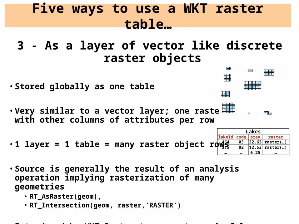
3 - As a layer of vector like discrete raster objects
• Stored globally as one table
• Very similar to a vector layer; one raster column with other columns of attributes per row
• 1 layer = 1 table = many raster object rows
• Source is generally the result of an analysis operation implying rasterization of many geometries
• RT_AsRaster(geom),• RT_Intersection(geom, raster,’RASTER’)
• Introduced by WKT Raster to support meaningful raster/vector operations
Five ways to use a WKT raster table…
LakeslakeId code area raster
464 03 32.63 raster(…)375 02 12.53 raster(…)… … 6.25 …
Five ways to use a WKT raster table…
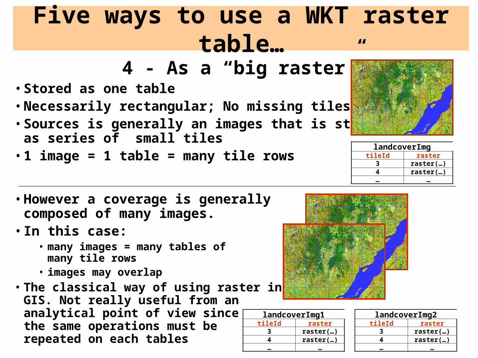
4 - As a “big raster”• Stored as one table• Necessarily rectangular; No missing tiles• Sources is generally an images that is stored
as series of small tiles• 1 image = 1 table = many tile rows
• However a coverage is generally composed of many images.
• In this case:• many images = many tables of
many tile rows• images may overlap
• The classical way of using raster in a GIS. Not really useful from an analytical point of view since the same operations must be repeated on each tables
landcoverImgtileId raster
3 raster(…)4 raster(…)… …
landcoverImg1tileId raster
3 raster(…)4 raster(…)… …
landcoverImg2tileId raster
3 raster(…)4 raster(…)… …
Five ways to use a WKT raster table…
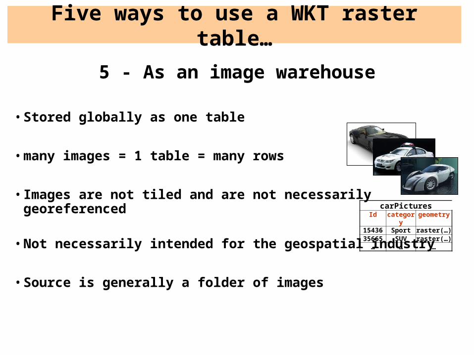
5 - As an image warehouse
• Stored globally as one table
• many images = 1 table = many rows
• Images are not tiled and are not necessarily georeferenced
• Not necessarily intended for the geospatial industry
• Source is generally a folder of images
carPicturesId category geometry
15436 Sport raster(…)35665 SUV raster(…)
… … …
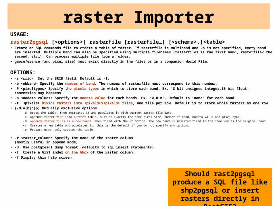
raster ImporterUSAGE:
raster2pgsql [<options>] rasterfile [rasterfile…] [<schema>.]<table>• Create an SQL commands file to create a table of raster. If rasterfile is multiband and –b is not specified, every band are inserted. Multiple
band can also be specified using multiple filenames (rasterfile1 is the first band, rasterfile2 the second, etc…). Can process multiple file from a folder.
• georeference (and pixel size) must exist directly in the files or in a companion World File.
OPTIONS:• -s <srid> Set the SRID field. Default is -1.
• -b <nbband> Specify the number of band. The number of rasterfile must correspond to this number.
• -P <pixeltypes> Specify the pixels types in which to store each band. Ex. ‘8-bit unsigned integer,16-bit float’. conversion may happens.
• -n <nodata values> Specify the nodata value for each bands. Ex. ‘0,0.0’. Default to ‘none’ for each band.
• -t <pixels> Divide rasters into <pixels>x<pixels> tiles, one tile per row. Default is to store whole rasters as one row.
• (-d|a|b|c|p) Mutually exclusive options:– d Drops the table, then recreates it and populates it with current raster file data.– a Appends raster file into current table, must be exactly the same pixel size, number of band, nodata value and pixel type.– B Appends raster files as a new bands. When tiled with the –t option, the new band is inserted tiled in the same way as the original band.– c Creates a new table and populates it, this is the default if you do not specify any options.– p Prepare mode, only creates the table.
• -r <raster_column> Specify the name of the raster column (mostly useful in append mode).
• -D Use postgresql dump format (defaults to sql insert statements).
• -I Create a GiST index on the bbox of the raster column.
• -? Display this help screen
Should rast2pgsql produce a SQL file like shp2pgsql or insert rasters directly in
PostGIS?
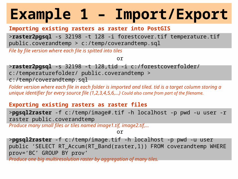
Example 1 – Import/ExportImporting existing rasters as raster into PostGIS
>raster2pgsql -s 32198 -t 128 -i forestcover.tif temperature.tif public.coverandtemp > c:/temp/coverandtemp.sqlFile by file version where each file is spitted into tiles
or
>raster2pgsql -s 32198 -t 128,tid -i c:/forestcoverfolder/ c:/temperaturefolder/ public.coverandtemp > c:/temp/coverandtemp.sqlFolder version where each file in each folder is imported and tiled. tid is a target column storing a unique identifier for every source file (1,2,3,4,5,6,…) Could also come from part of the filename.
Exporting existing rasters as raster files
>pgsql2raster -f c:/temp/image#.tif -h localhost -p pwd -u user -r raster public.coverandtempProduce many small files or tiles named image1.tif, image2.tif,…
or
>pgsql2raster -f c:/temp/image.tif -h localhost -p pwd -u user public ‘SELECT RT_Accum(RT_Band(raster,1)) FROM coverandtemp WHERE prov=‘BC’ GROUP BY prov’Produce one big multiresolution raster by aggregation of many tiles.
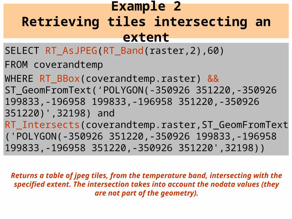
SELECT RT_AsJPEG(RT_Band(raster,2),60)
FROM coverandtemp
WHERE RT_BBox(coverandtemp.raster) && ST_GeomFromText(‘POLYGON(-350926 351220,-350926 199833,-196958 199833,-196958 351220,-350926 351220)',32198) and RT_Intersects(coverandtemp.raster,ST_GeomFromText('POLYGON(-350926 351220,-350926 199833,-196958 199833,-196958 351220,-350926 351220',32198))
Example 2Retrieving tiles intersecting an extent
Returns a table of jpeg tiles, from the temperature band, intersecting with the specified extent. The intersection takes into account the nodata values (they are
not part of the geometry).
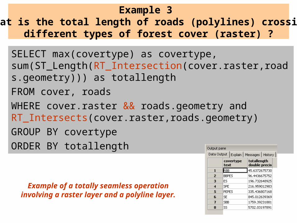
SELECT max(covertype) as covertype, sum(ST_Length(RT_Intersection(cover.raster,roads.geometry))) as totallength
FROM cover, roads
WHERE cover.raster && roads.geometry and RT_Intersects(cover.raster,roads.geometry)
GROUP BY covertype
ORDER BY totallength
Example 3 What is the total length of roads (polylines) crossing
different types of forest cover (raster) ?
Example of a totally seamless operation involving a raster layer and a polyline layer.
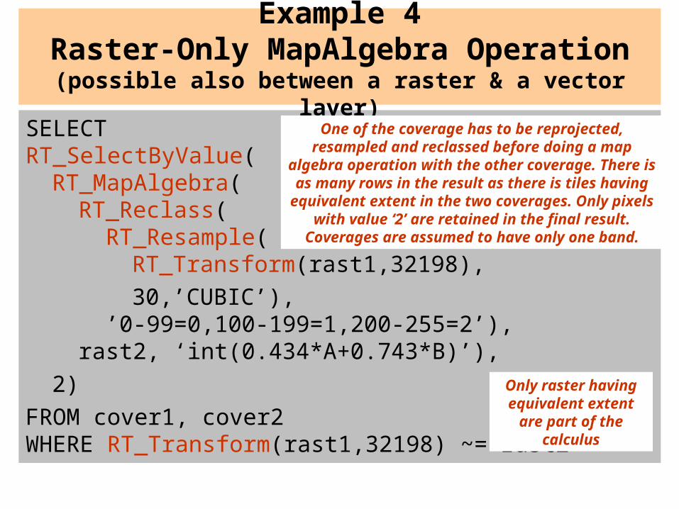
SELECT RT_SelectByValue(
RT_MapAlgebra(RT_Reclass(
RT_Resample(RT_Transform(rast1,32198),
30,’CUBIC’),’0-99=0,100-199=1,200-255=2’),
rast2, ‘int(0.434*A+0.743*B)’),
2)
FROM cover1, cover2WHERE RT_Transform(rast1,32198) ~= rast2
Example 4Raster-Only MapAlgebra Operation
(possible also between a raster & a vector layer)
One of the coverage has to be reprojected, resampled and reclassed before doing a map
algebra operation with the other coverage. There is as many rows in the result as there is tiles having
equivalent extent in the two coverages. Only pixels with value ‘2’ are retained in the final result.
Coverages are assumed to have only one band.
Only raster having equivalent extent are part of the calculus
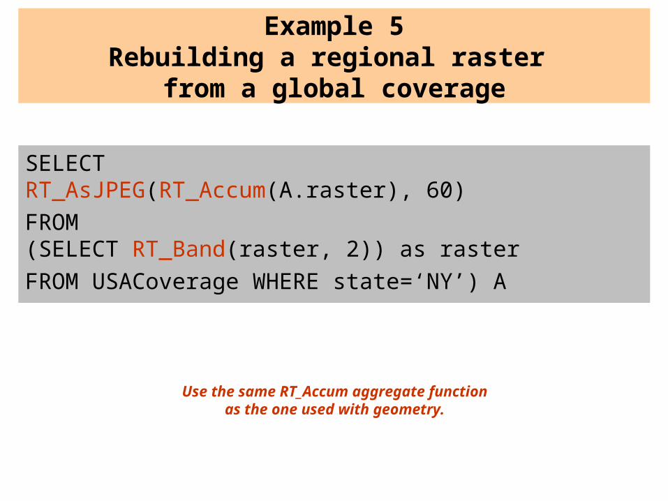
SELECTRT_AsJPEG(RT_Accum(A.raster), 60)
FROM(SELECT RT_Band(raster, 2)) as raster
FROM USACoverage WHERE state=‘NY’) A
Example 5Rebuilding a regional raster
from a global coverage
Use the same RT_Accum aggregate function as the one used with geometry.
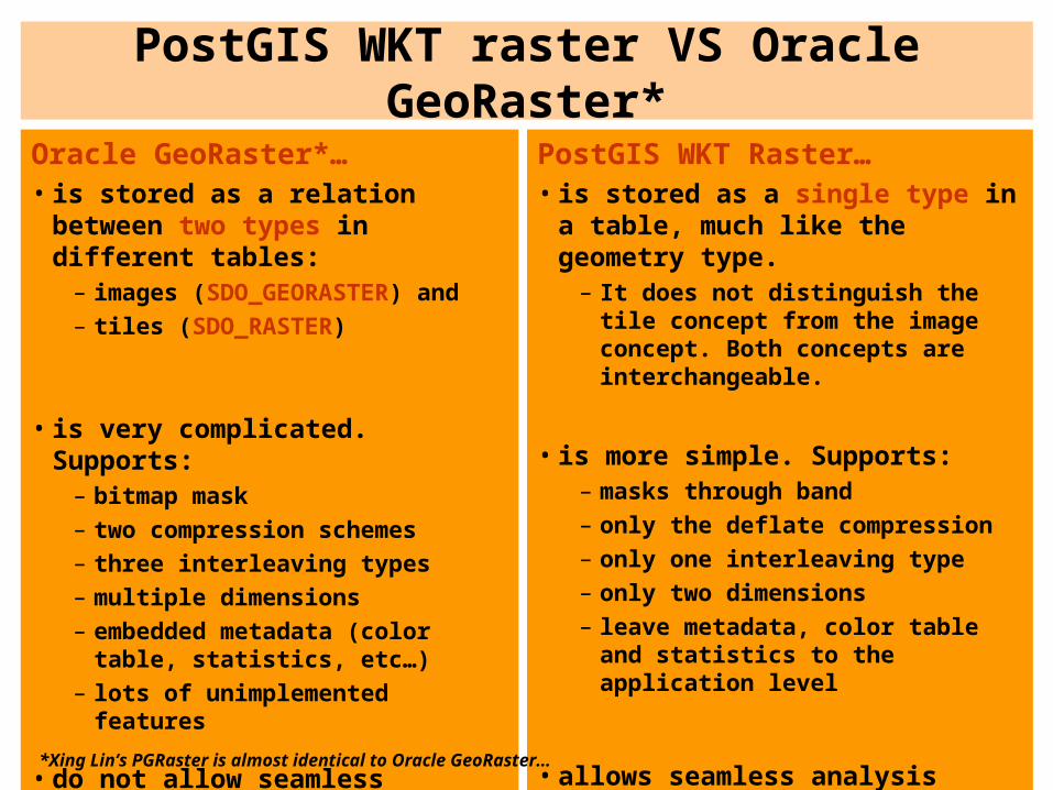
PostGIS WKT raster VS Oracle GeoRaster*
Oracle GeoRaster*…• is stored as a relation between two
types in different tables:– images (SDO_GEORASTER) and– tiles (SDO_RASTER)
• is very complicated. Supports:– bitmap mask– two compression schemes– three interleaving types– multiple dimensions– embedded metadata (color table,
statistics, etc…)– lots of unimplemented features
• do not allow seamless analysis operations with vector geometries
PostGIS WKT Raster…• is stored as a single type in a table,
much like the geometry type.– It does not distinguish the tile
concept from the image concept. Both concepts are interchangeable.
• is more simple. Supports:– masks through band– only the deflate compression– only one interleaving type– only two dimensions– leave metadata, color table and
statistics to the application level
• allows seamless analysis operations with vector geometries
*Xing Lin’s PGRaster is almost identical to Oracle GeoRaster…
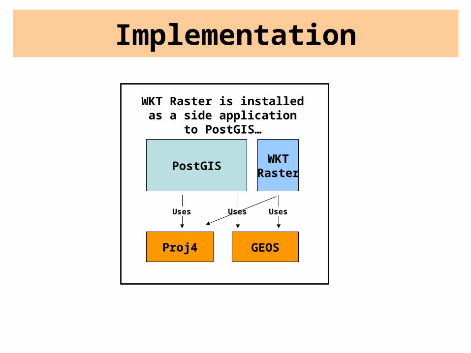
Implementation
PostGIS
Proj4 GEOS
Uses Uses
WKTRaster
Uses
WKT Raster is installed as a side application to PostGIS…
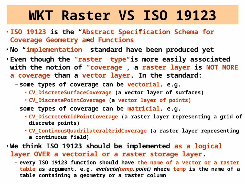
• ISO 19123 is the “Abstract Specification Schema for Coverage Geometry and Functions”
• No “implementation” standard have been produced yet• Even though the “raster” type is more easily associated with the notion
of “coverage”, a raster layer is NOT MORE a coverage than a vector layer. In the standard:
– some types of coverage can be vectorial. e.g.• CV_DiscreteSurfaceCoverage (a vector layer of surfaces)• CV_DiscretePointCoverage (a vector layer of points)
– some types of coverage can be matricial. e.g.• CV_DiscreteGridPointCoverage (a raster layer representing a grid of discrete
points)• CV_ContinousQuadrilateralGridCoverage (a raster layer representing a
continuous field)
• We think ISO 19123 should be implemented as a logical layer OVER a vectorial or a raster storage layer.
– every ISO 19123 function should have the name of a vector or a raster table as argument. e.g. evaluate(temp, point) where temp is the name of a table containing a geometry or a raster column
WKT Raster VS ISO 19123
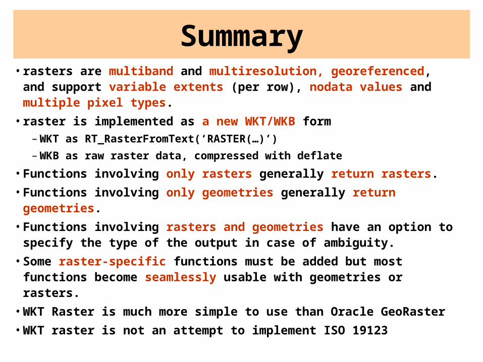
Summary• rasters are multiband and multiresolution, georeferenced, and
support variable extents (per row), nodata values and multiple pixel types.
• raster is implemented as a new WKT/WKB form– WKT as RT_RasterFromText(‘RASTER(…)’)
– WKB as raw raster data, compressed with deflate
• Functions involving only rasters generally return rasters.
• Functions involving only geometries generally return geometries.
• Functions involving rasters and geometries have an option to specify the type of the output in case of ambiguity.
• Some raster-specific functions must be added but most functions become seamlessly usable with geometries or rasters.
• WKT Raster is much more simple to use than Oracle GeoRaster
• WKT raster is not an attempt to implement ISO 19123
Priorities and Planning
See the WKT Raster wiki page for planning and funding:
http://postgis.refractions.net/support/wiki/index.php?WKTRasterHomePage

Acknowledgements
• Steve Cumming ([email protected]), Canada Research Chair in Boreal Ecosystems Modelling, for having initiated this project and financing it through a Canada Foundation for Innovation grant.
• Thierry Badard (http://geosoa.scg.ulaval.ca), Professor/full time researcher at Centre for Research in Geomatics, Université Laval, Quebec, Canada for his valuable comments, revisions, expertise and discussions.

Funding and Future Opportunities• Actual Funding - The Boreal Avian Modeling (BAM) project and the Canadian
Foundation for Innovation (CFI) are financing development of a web-based GIS tool to automate buffer operations on large spatial datasets. The objective is to support ecological analysis by reducing the overhead of GIS expertise and data assembly. A half-time position (Pierre Racine) is supported to develop a system prototype including raster integration in PostGIS.
• Extended Funding - Steve Cumming and Thierry Badard aim at initiating a new project to complement the funding of the project (and hence enable the financial support of another developer) and explore new avenues for geospatial data analysis provided by such a raster support (e.g. raster based Spatial OLAP applications).
• Interested? - If you are interested in such an implementation of the raster support in/with PostGIS and/or in participating to the new project, do not hesitate to contact Pierre Racine ([email protected]), Steve Cumming ([email protected]) and Thierry Badard ([email protected]).