Embed Size (px)
Citation preview

BookletChart™ Potomac River – Lower Cedar Point to Mattawoman Creek NOAA Chart 12288
A reduced-scale NOAA nautical chart for small boaters When possible, use the full-size NOAA chart for navigation.

2
Published by the National Oceanic and Atmospheric Administration
National Ocean Service Office of Coast Survey
www.NauticalCharts.NOAA.gov 888-990-NOAA
What are Nautical Charts?
Nautical charts are a fundamental tool of marine navigation. They show water depths, obstructions, buoys, other aids to navigation, and much more. The information is shown in a way that promotes safe and efficient navigation. Chart carriage is mandatory on the commercial ships that carry America’s commerce. They are also used on every Navy and Coast Guard ship, fishing and passenger vessels, and are widely carried by recreational boaters.
What is a BookletChart?
This BookletChart is made to help recreational boaters locate themselves on the water. It has been reduced in scale for convenience, but otherwise contains all the information of the full-scale nautical chart. The bar scales have also been reduced, and are accurate when used to measure distances in this BookletChart. See the Note at the bottom of page 5 for the reduction in scale applied to this chart.
Whenever possible, use the official, full scale NOAA nautical chart for navigation. Nautical chart sales agents are listed on the Internet at http://www.NauticalCharts.NOAA.gov.
This BookletChart does NOT fulfill chart carriage requirements for regulated commercial vessels under Titles 33 and 44 of the Code of Federal Regulations.
Notice to Mariners Correction Status
This BookletChart has been updated for chart corrections published in the U.S. Coast Guard Local Notice to Mariners, the National Geospatial Intelligence Agency Weekly Notice to Mariners, and, where applicable, the Canadian Coast Guard Notice to Mariners. Additional chart corrections have been made by NOAA in advance of their publication in a Notice to Mariners. The last Notices to Mariners applied to this chart are listed in the Note at the bottom of page 7. Coast Pilot excerpts are not being corrected.
For latest Coast Pilot excerpt visit the Office of Coast Survey website at http://www.nauticalcharts.noaa.gov/nsd/searchbychart.php?chart=12288
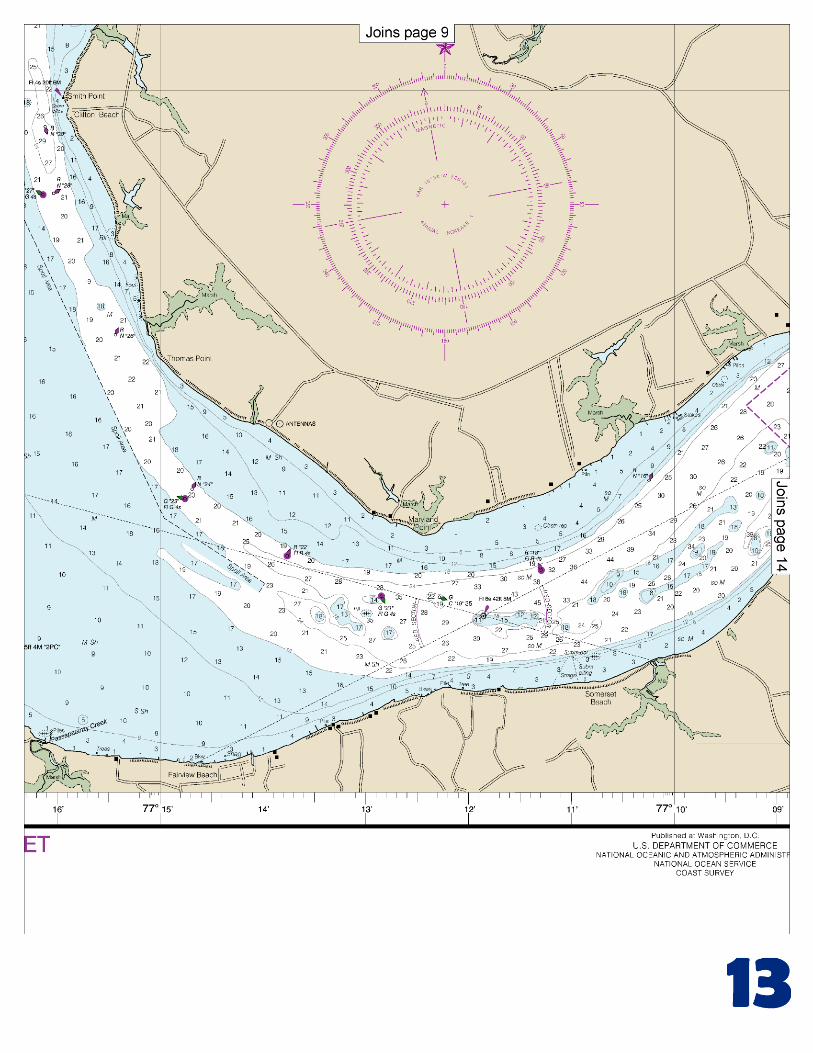
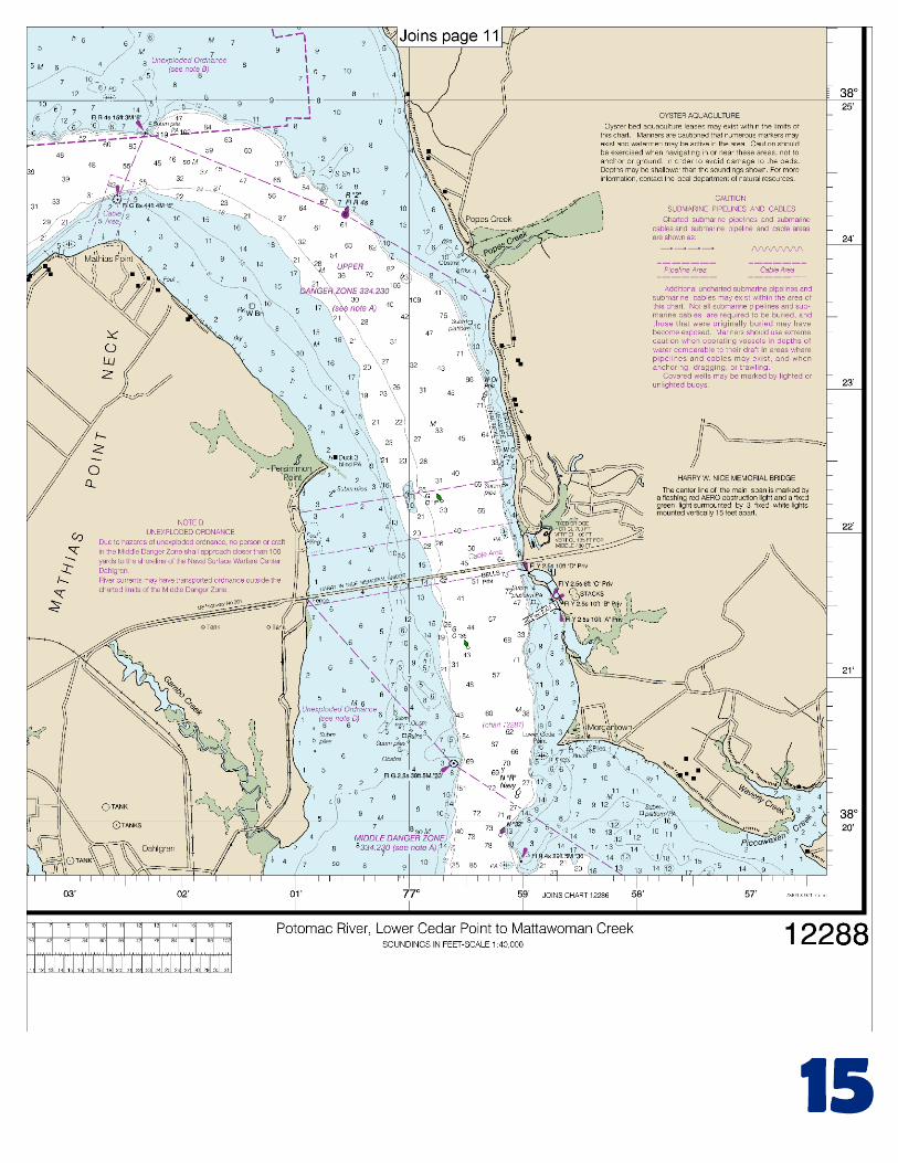
(Selected Excerpts from Coast Pilot) There is a small-boat basin and marina just above the Harry W. Nice Bridge. The entrance channel and basin have depths of 6 feet. Gasoline, diesel fuel, berths, and marine supplies are available. A danger zone for military testing operations extends 4 miles upriver from the Harry W. Nice Bridge. Persimmon Point. A 3-foot shoal is 0.6 mile southeastward of the point on the west edge of the channel.
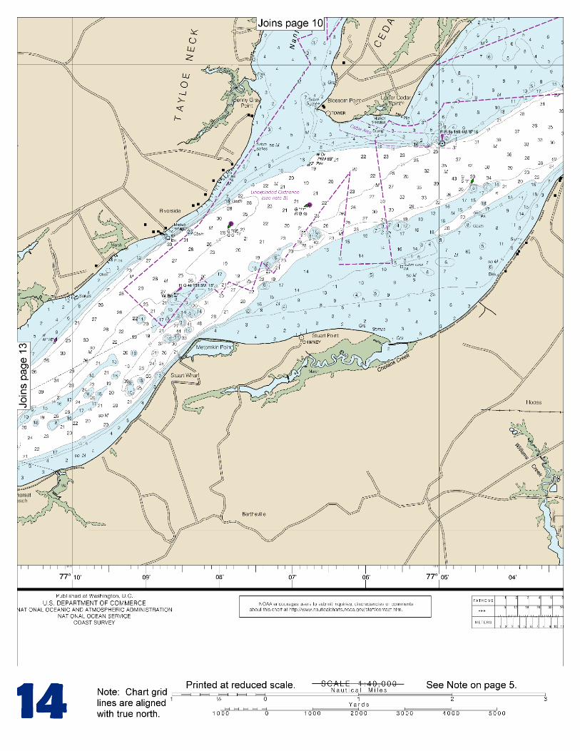
Popes Creek is not navigable. The village of Popes Creek 0.2 mile northward, has limited quantities of gasoline available at a pier. Between Popes Creek and Upper Cedar Point, the Maryland shore of
Potomac River bends northward 2 miles to form Tobacco River Flats, which have shoal spots of 3 to 5 feet but generally navigable depths of 7 to 10 feet. Port Tobacco River, at the head of the bight, has depths of 7 feet for 1.6 miles and thence 5 to 3 feet for another 1.3 miles. A light and daybeacons mark the channel. Port Tobacco is now the head of navigation. Marinas at the town have gasoline, berths, and some supplies. Upper Cedar Point is marked by a light shown from a skeleton tower on piles in depths of 3 feet on the north edge of the channel. Give the light a berth of at least 200 yards. Nanjemoy Creek has a controlling depth of 4 feet in a marked channel to a small craft launching ramp 4 miles above the entrance. Metomkin Point. A light, shown from a pile structure in depths of 1 foot 0.5 mile off the point, marks the shallowest part of a shoal area along the southeast edge of the channel. Maryland Point Light (38°21.0'N., 77°11.9'W.) is shown from a skeleton tower with a black and white diamond-shaped daymark on piles in depths of 9 feet on the south edge of the Potomac River channel. Other shoals east and west of the light are marked by buoys. Gasoline and some supplies can be obtained at Fairview Beach. Depths to the fuel pier are 4 feet. Potomac Creek is used only by small motorboats. The creek has depths of 7 feet in the entrance, thence 3 feet for 2 miles. The best water favors the south side of the entrance. Gasoline and water are available at small-craft facilities on the south side of the creek 1 mile and 2 miles above the entrance. Aquia Creek has depths of 4 to 5 feet to the railroad bridge, and thence 2 feet to Coals Landing. The entrance is marked by lights and daybeacons. Small-craft facilities are on the south side of the creek close above and below the bridge There is danger of striking submerged hulks in the mile-wide former restricted anchorage area that extended 2.5 miles upriver along the Virginia shore from directly opposite Smith Point. Mallows Bay is a ship graveyard area; the western danger limit is a line from Liverpool Point to Sandy Point. A buoy marks the inner edge of the river channel off the bay. The southern part of the bay has unobstructed depths of 5 feet to the submerged wreck near the head. An aviation school wharf at Mile 66.2W has depths of 8 feet at the outer end. The short dredged channel to the wharf has a reported controlling depth of 6 feet. About 0.2 mile north of the wharf, a diversion canal 5 feet deep connects Chopawamsic Creek with the Potomac River. Quantico is a training site of the U.S. Marine Corps. Except in emergencies, the pier and harbor are restricted to government vessels. Anchorages.–Vessels bound up or down the river anchor anywhere near the channel where the bottom is soft; vessels sometimes anchor in Cornfield Harbor or St. Marys River. Danger zones and restricted area.–The Potomac River and its tributaries are used extensively by the military establishments for testing operations and gunnery practice. (Limits and regulations for these areas are given in 334.230, 334.240, and 334.250, chapter 2.) Currents.–The current in Chesapeake Bay off the mouth of Potomac River can be hazardous to smaller vessels and pleasure boats at ebb tide, and when wind and current are opposed, and with northwest winds. Pilotage, Potomac River.–Pilotage is compulsory on the Potomac River for foreign vessels and U.S. vessels under register in the foreign trade.
U.S. Coast Guard Rescue Coordination Center
24 hour Regional Contact for Emergencies
RCC Norfolk Commander 5th CG District (575) 398-6231 Norfolk, VA

G
NOAA’s navigation managers serve as ambassadors to the maritime community. They help identify navigational challenges facing professional and recreational mariners, and provide NOAA resources and information for safe navigation. For additional information, please visit nauticalcharts.noaa.gov/service/navmanagers
To make suggestions or ask questions online, go to nauticalcharts.noaa.gov/inquiry. To report a chart discrepancy, please use ocsdata.ncd.noaa.gov/idrs/discrepancy.aspx.
Lateral System As Seen Entering From Seaward on navigable waters except Western Rivers
PORT SIDE
ODD NUMBERED AIDS
GREEN LIGHT ONLY
FLASHING (2)
PREFERRED CHANNEL
NO NUMBERS – MAY BE LETTERED
PREFERRED CHANNEL TO
STARBOARD
TOPMOST BAND GREEN
PREFERRED CHANNEL
NO NUMBERS – MAY BE LETTERED
PREFERRED CHANNEL
TO PORT
TOPMOST BAND RED
STARBOARD SIDE
EVEN NUMBERED AIDS
RED LIGHT ONLY
FLASHING (2)
FLASHING FLASHING
OCCULTING GREEN LIGHT ONLY RED LIGHT ONLY OCCULTING QUICK FLASHING QUICK FLASHING
ISO COMPOSITE GROUP FLASHING (2+1) COMPOSITE GROUP FLASHING (2+1) ISO
"1"
Fl G 6s
G "9"
Fl G 4s
GR "A"
Fl (2+1) G 6s
RG "B"
Fl (2+1) R 6s
"2"
Fl R 6s
8
R "8"
Fl R 4s
LIGHT
G
C "1"
LIGHTED BUOY
G
"5"
GR
"U"
GR
C "S"
RG
N "C"
RG
"G"
LIGHT
6
R
N "6"
LIGHTED BUOY
R
"2
"
CAN DAYBEACON
CAN NUN NUN
DAYBEACON
For more information on aids to navigation, including those on Western Rivers, please consult the latest USCG Light List for your area.
These volumes are available online at http://www.navcen.uscg.gov
Navigation Managers Area of Responsibility
Northeast
Lt. Meghan McGovern
Northwest and
Pacific Islands
Crescent Moegling
Great Lakes Region
Tom Loeper
Chesapeake and
Delaware Bay
Steve Soherr
California
Jeff Ferguson
[email protected] Mid-Atlantic
Lt. Ryan Wartick
Alaska
Lt. Timothy M. Smith
Western Gulf Coast
Alan Bunn
Central Gulf Coast
Tim Osborn
[email protected] South Florida
Puerto Rico
U.S. Virgin Islands
Michael Henderson
Southeast
Kyle Ward
2
2 C U 5
1


VHF Marine Radio channels for use on the waterways:Channel 6 – Inter-ship safety communications.Channel 9 – Communications between boats and ship-to-coast.Channel 13 – Navigation purposes at bridges, locks, and harbors.Channel 16 – Emergency, distress and safety calls to Coast Guard and others, and to initiate calls to other
vessels. Contact the other vessel, agree to another channel, and then switch.Channel 22A – Calls between the Coast Guard and the public. Severe weather warnings, hazards to navigation and safety warnings are broadcast here.Channels 68, 69, 71, 72 and 78A – Recreational boat channels.
Getting and Giving Help — Signal other boaters using visual distress signals (flares, orange flag, lights, arm signals); whistles; horns; and on your VHF radio. You are required by law to help boaters in trouble. Respond to distress signals, but do not endanger yourself.
EMERGENCY INFORMATION
Distress Call Procedures
• Make sure radio is on.• Select Channel 16.• Press/Hold the transmit button.• Clearly say: “MAYDAY, MAYDAY, MAYDAY.”• Also give: Vessel Name and/or Description;Position and/or Location; Nature of Emergency; Number of People on Board.• Release transmit button.• Wait for 10 seconds — If no responseRepeat MAYDAY call.
HAVE ALL PERSONS PUT ON LIFE JACKETS!
This Booklet chart has been designed for duplex printing (printed on front and back of one sheet). If a duplex option is not available on your printer, you may print each sheet and arrange them back-to-back to allow for the proper layout when viewing.
QR
Quick ReferencesNautical chart related products and information - http://www.nauticalcharts.noaa.gov
Interactive chart catalog - http://www.charts.noaa.gov/InteractiveCatalog/nrnc.shtmlReport a chart discrepancy - http://ocsdata.ncd.noaa.gov/idrs/discrepancy.aspx
Chart and chart related inquiries and comments - http://ocsdata.ncd.noaa.gov/idrs/inquiry.aspx?frompage=ContactUs
Chart updates (LNM and NM corrections) - http://www.nauticalcharts.noaa.gov/mcd/updates/LNM_NM.html
Coast Pilot online - http://www.nauticalcharts.noaa.gov/nsd/cpdownload.htm
Tides and Currents - http://tidesandcurrents.noaa.gov
Marine Forecasts - http://www.nws.noaa.gov/om/marine/home.htm
National Data Buoy Center - http://www.ndbc.noaa.gov/
NowCoast web portal for coastal conditions - http://www.nowcoast.noaa.gov/
National Weather Service - http://www.weather.gov/
National Hurrican Center - http://www.nhc.noaa.gov/
Pacific Tsunami Warning Center - http://ptwc.weather.gov/
Contact Us - http://www.nauticalcharts.noaa.gov/staff/contact.htm
NOAA’s Office of Coast Survey The Nation’s Chartmaker
For the latest news from Coast Survey, follow @NOAAcharts
NOAA Weather Radio All Hazards (NWR) is a nationwide network of radio stations broadcasting continuous weather information directly from the nearest National Weather Service office. NWR broadcasts official Weather Service warnings, watches, forecasts and other hazard information 24 hours a day, 7 days a week. http://www.nws.noaa.gov/nwr/