Embed Size (px)
Citation preview
39
INTRODUCTION
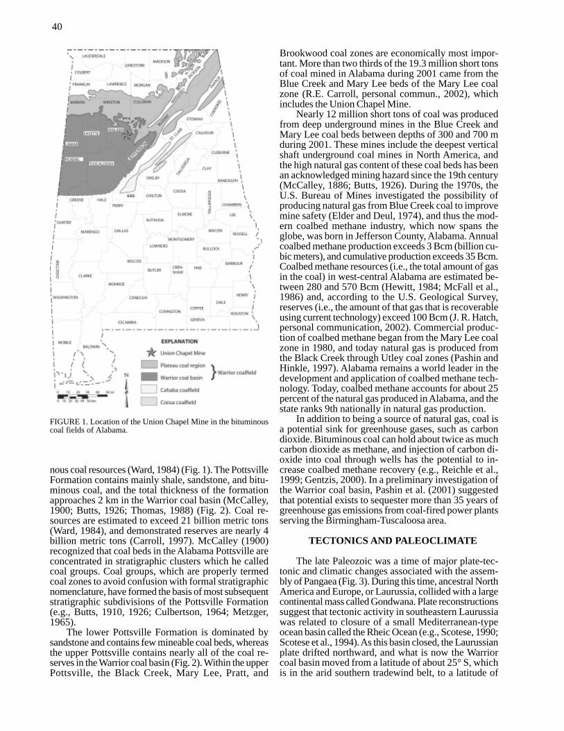
The Union Chapel Mine has yielded a prolific as-semblage of amphibian trackways (Cincosaurus cobbiAldrich, 1930) and associated invertebrate trace fossilsthat provides a unique window into life during EarlyPennsylvanian time. The fossil locality at Union Chapelhas characteristics of a Konzentrat-Lagerstätte becauseof exceptional abundance and a Preservat-Lagerstättebecause of exceptional preservation of detail (e.g.,Seilacher, 1990). The Union Chapel Mine is a surfacecoal mine in the Warrior coal basin of Walker County,Alabama (Fig. 1). The mine covers parts of the easternhalf of sec. 21 and the western half of sec. 22, T. 14 S.,R. 6 W. in the Cordova 7.5-minute topographic quad-rangle and is excavated into Pennsylvanian-age strataof the Pottsville Formation. Nearly all of the fossil ma-terial recovered has come from the mine spoils and, priorto some stabilization and reclamation activities, stratawere preserved intact in a highwall that was in placestaller than 30 m. Examination of the mine face indicatesthat strata containing a series of distinctive fossil as-semblages were deposited in a wide range of deposi-tional environments that place the trackway discoveryinto geologic context.
Amphibian trackways have been known fromAlabama’s coal mines for more than 75 years (Aldrichand Jones, 1930; Rindsberg, 1990), yet little is knownabout the ancient environments in which the trackwayswere preserved. The objective of this paper is to charac-
terize the Union Chapel lagerstätte in terms of stratigra-phy (i.e., the time-space relationships of sedimentaryrock) and environments of deposition. These strata pro-vide evidence for local conditions as the trackwaysformed and also provide a compact record of the tec-tonic and climatic processes that operated globally ascontinental masses came together to form the supercon-tinent Pangaea.
Characterization of the Union Chapel lagerstätteunderscores the relevance of geology to our everydaylives and demonstrates that fossil finds are not merelyacademic curiosities. The Pottsville Formation is an im-portant source of coal and natural gas that are used formany purposes, including electric power generation,metallurgy, and home heating. Geologists routinely char-acterize the paleontology, stratigraphy, and sedimentol-ogy of these strata to predict the distribution, quantity,and quality of coal and natural gas resources, therebyensuring a stable supply of energy for the future.
POTTSVILLE FORMATION
Economic coal-bearing strata in Alabama are re-stricted mainly to the Pottsville Formation of Early Penn-sylvanian age (Morrowan Epoch), which has been datedusing fossil spores and marine invertebrates (Butts, 1926;Eble and Gillespie, 1989; Eble et al., 1991). The UnionChapel Mine is in the Warrior coal basin, which under-lies most of Walker, Jefferson, and Tuscaloosa countiesand includes nearly 90 percent of Alabama’s bitumi-
POTTSVILLE STRATIGRAPHY AND THE UNION CHAPEL LAGERSTÄTTE
JACK C. PASHINGeological Survey of Alabama, P.O. Box 869999, Tuscaloosa, Alabama, 35486-6999, USA
ABSTRACT: Amphibian trackways from the Pennsylvanian-aged Pottsville Formation at theUnion Chapel Mine are part of a fossil-lagerstätte, or motherlode, that provides exceptionalinsight into ancient life and environments. The trackways come from the Cincosaurus beds,which constitute one of many fossiliferous intervals exposed in the mine. These intervals con-tain different fossil assemblages representing a spectrum of terrestrial to marine environmentsof deposition.
The Mary Lee coal bed is a source of low-sulfur coal and represents a widespread peat swamp;it was mined at Union Chapel as a source of high-quality fuel for electric power generation. TheCincosaurus beds were deposited on an estuarine mudflat that formed as the Mary Lee swampwas inundated by sediment-laden water. The Cincosaurus beds represent a dynamic environ-ment in which amphibians (makers of the trackway Cincosaurus cobbi) and a variety of inver-tebrates ventured onto the mudflat at low tide. Deposition of the Cincosaurus beds apparentlyended with a drop of relative sea level and widespread soil development. This event was suc-ceeded by a return to peat-swamp sedimentation, as represented by the overlying New Castlecoal, which was also mined at Union Chapel. The roof shale of the New Castle coal containsstanding fossil forests and represents a swamp that was prone to flooding by mud-laden water.Above the roof shale is a thin bed of nodular limestone containing brachiopods and bivalves,which records a major marine transgression. Above the limestone is a thick, coarsening-upwardsuccession of shale and sandstone that contains marine trace fossils and was deposited in prodeltaand delta-front environments during a relative highstand of sea level.
Buta, R. J., Rindsberg, A. K., and Kopaska-Merkel, D. C., eds., 2005, Pennsylvanian Footprints in the Black Warrior Basin of Alabama.Alabama Paleontological Society Monograph no. 1.
40
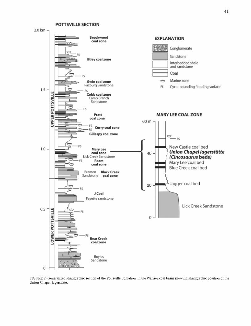
nous coal resources (Ward, 1984) (Fig. 1). The PottsvilleFormation contains mainly shale, sandstone, and bitu-minous coal, and the total thickness of the formationapproaches 2 km in the Warrior coal basin (McCalley,1900; Butts, 1926; Thomas, 1988) (Fig. 2). Coal re-sources are estimated to exceed 21 billion metric tons(Ward, 1984), and demonstrated reserves are nearly 4billion metric tons (Carroll, 1997). McCalley (1900)recognized that coal beds in the Alabama Pottsville areconcentrated in stratigraphic clusters which he calledcoal groups. Coal groups, which are properly termedcoal zones to avoid confusion with formal stratigraphicnomenclature, have formed the basis of most subsequentstratigraphic subdivisions of the Pottsville Formation(e.g., Butts, 1910, 1926; Culbertson, 1964; Metzger,1965).
The lower Pottsville Formation is dominated bysandstone and contains few mineable coal beds, whereasthe upper Pottsville contains nearly all of the coal re-serves in the Warrior coal basin (Fig. 2). Within the upperPottsville, the Black Creek, Mary Lee, Pratt, and
Brookwood coal zones are economically most impor-tant. More than two thirds of the 19.3 million short tonsof coal mined in Alabama during 2001 came from theBlue Creek and Mary Lee beds of the Mary Lee coalzone (R.E. Carroll, personal commun., 2002), whichincludes the Union Chapel Mine.
Nearly 12 million short tons of coal was producedfrom deep underground mines in the Blue Creek andMary Lee coal beds between depths of 300 and 700 mduring 2001. These mines include the deepest verticalshaft underground coal mines in North America, andthe high natural gas content of these coal beds has beenan acknowledged mining hazard since the 19th century(McCalley, 1886; Butts, 1926). During the 1970s, theU.S. Bureau of Mines investigated the possibility ofproducing natural gas from Blue Creek coal to improvemine safety (Elder and Deul, 1974), and thus the mod-ern coalbed methane industry, which now spans theglobe, was born in Jefferson County, Alabama. Annualcoalbed methane production exceeds 3 Bcm (billion cu-bic meters), and cumulative production exceeds 35 Bcm.Coalbed methane resources (i.e., the total amount of gasin the coal) in west-central Alabama are estimated be-tween 280 and 570 Bcm (Hewitt, 1984; McFall et al.,1986) and, according to the U.S. Geological Survey,reserves (i.e., the amount of that gas that is recoverableusing current technology) exceed 100 Bcm (J. R. Hatch,personal communication, 2002). Commercial produc-tion of coalbed methane began from the Mary Lee coalzone in 1980, and today natural gas is produced fromthe Black Creek through Utley coal zones (Pashin andHinkle, 1997). Alabama remains a world leader in thedevelopment and application of coalbed methane tech-nology. Today, coalbed methane accounts for about 25percent of the natural gas produced in Alabama, and thestate ranks 9th nationally in natural gas production.
In addition to being a source of natural gas, coal isa potential sink for greenhouse gases, such as carbondioxide. Bituminous coal can hold about twice as muchcarbon dioxide as methane, and injection of carbon di-oxide into coal through wells has the potential to in-crease coalbed methane recovery (e.g., Reichle et al.,1999; Gentzis, 2000). In a preliminary investigation ofthe Warrior coal basin, Pashin et al. (2001) suggestedthat potential exists to sequester more than 35 years ofgreenhouse gas emissions from coal-fired power plantsserving the Birmingham-Tuscaloosa area.
TECTONICS AND PALEOCLIMATE
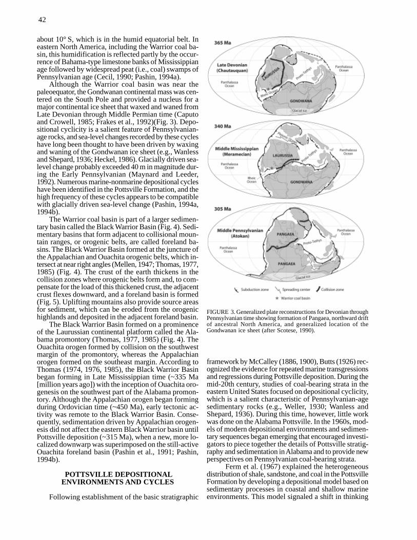
The late Paleozoic was a time of major plate-tec-tonic and climatic changes associated with the assem-bly of Pangaea (Fig. 3). During this time, ancestral NorthAmerica and Europe, or Laurussia, collided with a largecontinental mass called Gondwana. Plate reconstructionssuggest that tectonic activity in southeastern Laurussiawas related to closure of a small Mediterranean-typeocean basin called the Rheic Ocean (e.g., Scotese, 1990;Scotese et al., 1994). As this basin closed, the Laurussianplate drifted northward, and what is now the Warriorcoal basin moved from a latitude of about 25° S, whichis in the arid southern tradewind belt, to a latitude of
FIGURE 1. Location of the Union Chapel Mine in the bituminouscoal fields of Alabama.
41
FIGURE 2. Generalized stratigraphic section of the Pottsville Fomation in the Warrior coal basin showing stratigraphic position of theUnion Chapel lagerstätte.
42
about 10° S, which is in the humid equatorial belt. Ineastern North America, including the Warrior coal ba-sin, this humidification is reflected partly by the occur-rence of Bahama-type limestone banks of Mississippianage followed by widespread peat (i.e., coal) swamps ofPennsylvanian age (Cecil, 1990; Pashin, 1994a).
Although the Warrior coal basin was near thepaleoequator, the Gondwanan continental mass was cen-tered on the South Pole and provided a nucleus for amajor continental ice sheet that waxed and waned fromLate Devonian through Middle Permian time (Caputoand Crowell, 1985; Frakes et al., 1992)(Fig. 3). Depo-sitional cyclicity is a salient feature of Pennsylvanian-age rocks, and sea-level changes recorded by these cycleshave long been thought to have been driven by waxingand waning of the Gondwanan ice sheet (e.g., Wanlessand Shepard, 1936; Heckel, 1986). Glacially driven sea-level change probably exceeded 40 m in magnitude dur-ing the Early Pennsylvanian (Maynard and Leeder,1992). Numerous marine-nonmarine depositional cycleshave been identified in the Pottsville Formation, and thehigh frequency of these cycles appears to be compatiblewith glacially driven sea-level change (Pashin, 1994a,1994b).
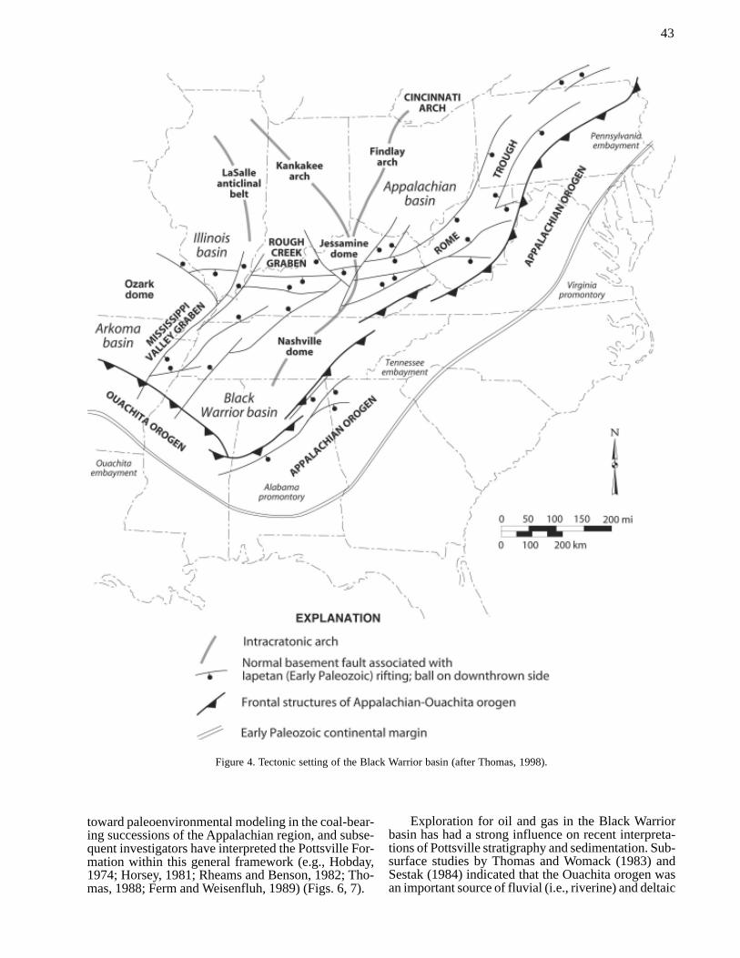
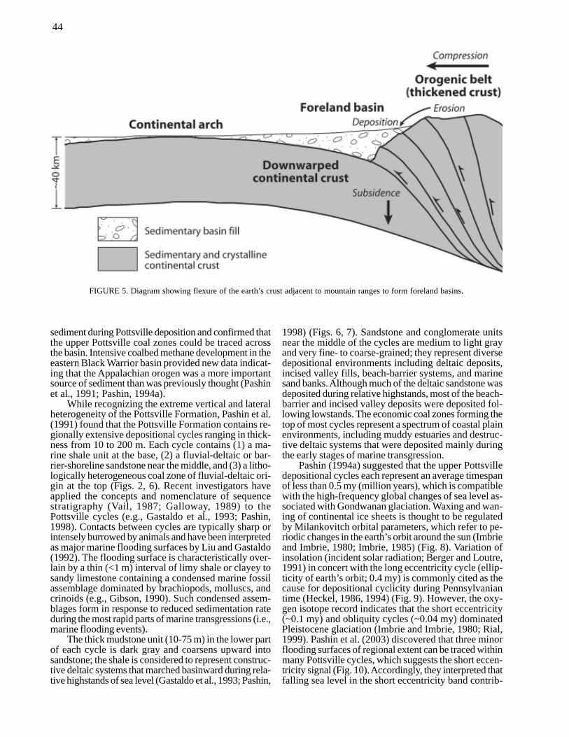
The Warrior coal basin is part of a larger sedimen-tary basin called the Black Warrior Basin (Fig. 4). Sedi-mentary basins that form adjacent to collisional moun-tain ranges, or orogenic belts, are called foreland ba-sins. The Black Warrior Basin formed at the juncture ofthe Appalachian and Ouachita orogenic belts, which in-tersect at near right angles (Mellen, 1947; Thomas, 1977,1985) (Fig. 4). The crust of the earth thickens in thecollision zones where orogenic belts form and, to com-pensate for the load of this thickened crust, the adjacentcrust flexes downward, and a foreland basin is formed(Fig. 5). Uplifting mountains also provide source areasfor sediment, which can be eroded from the orogenichighlands and deposited in the adjacent foreland basin.
The Black Warrior Basin formed on a prominenceof the Laurussian continental platform called the Ala-bama promontory (Thomas, 1977, 1985) (Fig. 4). TheOuachita orogen formed by collision on the southwestmargin of the promontory, whereas the Appalachianorogen formed on the southeast margin. According toThomas (1974, 1976, 1985), the Black Warrior Basinbegan forming in Late Mississippian time (~335 Ma[million years ago]) with the inception of Ouachita oro-genesis on the southwest part of the Alabama promon-tory. Although the Appalachian orogen began formingduring Ordovician time (~450 Ma), early tectonic ac-tivity was remote to the Black Warrior Basin. Conse-quently, sedimentation driven by Appalachian orogen-esis did not affect the eastern Black Warrior basin untilPottsville deposition (~315 Ma), when a new, more lo-calized downwarp was superimposed on the still-activeOuachita foreland basin (Pashin et al., 1991; Pashin,1994b).
POTTSVILLE DEPOSITIONALENVIRONMENTS AND CYCLES
Following establishment of the basic stratigraphic
framework by McCalley (1886, 1900), Butts (1926) rec-ognized the evidence for repeated marine transgressionsand regressions during Pottsville deposition. During themid-20th century, studies of coal-bearing strata in theeastern United States focused on depositional cyclicity,which is a salient characteristic of Pennsylvanian-agesedimentary rocks (e.g., Weller, 1930; Wanless andShepard, 1936). During this time, however, little workwas done on the Alabama Pottsville. In the 1960s, mod-els of modern depositional environments and sedimen-tary sequences began emerging that encouraged investi-gators to piece together the details of Pottsville stratig-raphy and sedimentation in Alabama and to provide newperspectives on Pennsylvanian coal-bearing strata.
Ferm et al. (1967) explained the heterogeneousdistribution of shale, sandstone, and coal in the PottsvilleFormation by developing a depositional model based onsedimentary processes in coastal and shallow marineenvironments. This model signaled a shift in thinking
FIGURE 3. Generalized plate reconstructions for Devonian throughPennsylvanian time showing formation of Pangaea, northward driftof ancestral North America, and generalized location of theGondwanan ice sheet (after Scotese, 1990).
43
toward paleoenvironmental modeling in the coal-bear-ing successions of the Appalachian region, and subse-quent investigators have interpreted the Pottsville For-mation within this general framework (e.g., Hobday,1974; Horsey, 1981; Rheams and Benson, 1982; Tho-mas, 1988; Ferm and Weisenfluh, 1989) (Figs. 6, 7).
Exploration for oil and gas in the Black Warriorbasin has had a strong influence on recent interpreta-tions of Pottsville stratigraphy and sedimentation. Sub-surface studies by Thomas and Womack (1983) andSestak (1984) indicated that the Ouachita orogen wasan important source of fluvial (i.e., riverine) and deltaic
Figure 4. Tectonic setting of the Black Warrior basin (after Thomas, 1998).
44
sediment during Pottsville deposition and confirmed thatthe upper Pottsville coal zones could be traced acrossthe basin. Intensive coalbed methane development in theeastern Black Warrior basin provided new data indicat-ing that the Appalachian orogen was a more importantsource of sediment than was previously thought (Pashinet al., 1991; Pashin, 1994a).
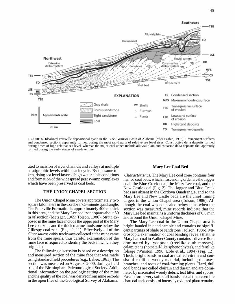
While recognizing the extreme vertical and lateralheterogeneity of the Pottsville Formation, Pashin et al.(1991) found that the Pottsville Formation contains re-gionally extensive depositional cycles ranging in thick-ness from 10 to 200 m. Each cycle contains (1) a ma-rine shale unit at the base, (2) a fluvial-deltaic or bar-rier-shoreline sandstone near the middle, and (3) a litho-logically heterogeneous coal zone of fluvial-deltaic ori-gin at the top (Figs. 2, 6). Recent investigators haveapplied the concepts and nomenclature of sequencestratigraphy (Vail, 1987; Galloway, 1989) to thePottsville cycles (e.g., Gastaldo et al., 1993; Pashin,1998). Contacts between cycles are typically sharp orintensely burrowed by animals and have been interpretedas major marine flooding surfaces by Liu and Gastaldo(1992). The flooding surface is characteristically over-lain by a thin (<1 m) interval of limy shale or clayey tosandy limestone containing a condensed marine fossilassemblage dominated by brachiopods, molluscs, andcrinoids (e.g., Gibson, 1990). Such condensed assem-blages form in response to reduced sedimentation rateduring the most rapid parts of marine transgressions (i.e.,marine flooding events).
The thick mudstone unit (10-75 m) in the lower partof each cycle is dark gray and coarsens upward intosandstone; the shale is considered to represent construc-tive deltaic systems that marched basinward during rela-tive highstands of sea level (Gastaldo et al., 1993; Pashin,
1998) (Figs. 6, 7). Sandstone and conglomerate unitsnear the middle of the cycles are medium to light grayand very fine- to coarse-grained; they represent diversedepositional environments including deltaic deposits,incised valley fills, beach-barrier systems, and marinesand banks. Although much of the deltaic sandstone wasdeposited during relative highstands, most of the beach-barrier and incised valley deposits were deposited fol-lowing lowstands. The economic coal zones forming thetop of most cycles represent a spectrum of coastal plainenvironments, including muddy estuaries and destruc-tive deltaic systems that were deposited mainly duringthe early stages of marine transgression.
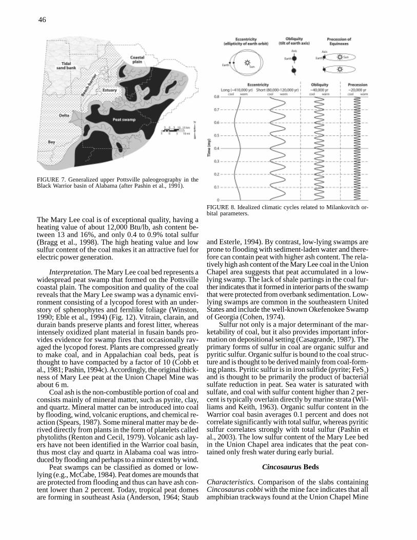
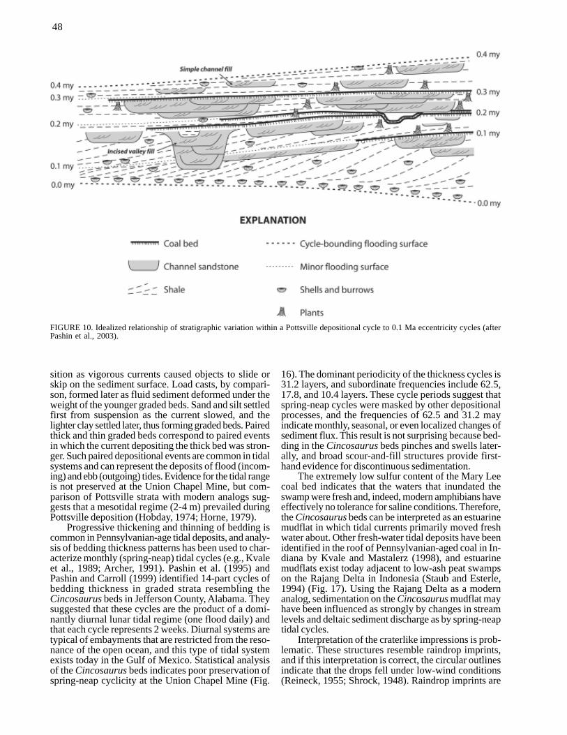
Pashin (1994a) suggested that the upper Pottsvilledepositional cycles each represent an average timespanof less than 0.5 my (million years), which is compatiblewith the high-frequency global changes of sea level as-sociated with Gondwanan glaciation. Waxing and wan-ing of continental ice sheets is thought to be regulatedby Milankovitch orbital parameters, which refer to pe-riodic changes in the earth’s orbit around the sun (Imbrieand Imbrie, 1980; Imbrie, 1985) (Fig. 8). Variation ofinsolation (incident solar radiation; Berger and Loutre,1991) in concert with the long eccentricity cycle (ellip-ticity of earth’s orbit; 0.4 my) is commonly cited as thecause for depositional cyclicity during Pennsylvaniantime (Heckel, 1986, 1994) (Fig. 9). However, the oxy-gen isotope record indicates that the short eccentricity(~0.1 my) and obliquity cycles (~0.04 my) dominatedPleistocene glaciation (Imbrie and Imbrie, 1980; Rial,1999). Pashin et al. (2003) discovered that three minorflooding surfaces of regional extent can be traced withinmany Pottsville cycles, which suggests the short eccen-tricity signal (Fig. 10). Accordingly, they interpreted thatfalling sea level in the short eccentricity band contrib-
FIGURE 5. Diagram showing flexure of the earth’s crust adjacent to mountain ranges to form foreland basins.
45
uted to incision of river channels and valleys at multiplestratigraphic levels within each cycle. By the same to-ken, rising sea level favored high water table conditionsand formation of the widespread peat swamp complexeswhich have been preserved as coal beds.
THE UNION CHAPEL SECTION
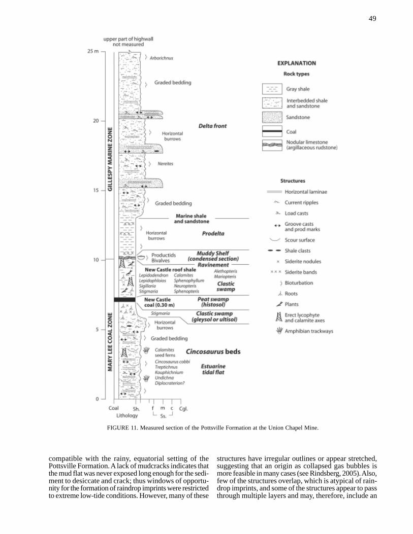
The Union Chapel Mine covers approximately twosquare kilometers in the Cordova 7.5-minute quadrangle.The Pottsville Formation is approximately 400 m thickin this area, and the Mary Lee coal zone spans about 30m of section (Metzger, 1965; Tolson, 1986). Strata ex-posed in the mine face include the upper part of the MaryLee coal zone and the thick marine mudstone below theGillespy coal zone (Figs. 2, 11). Effectively all of theCincosaurus cobbi trackways collected at the mine camefrom the mine spoils, thus careful examination of themine face is required to identify the beds in which theyoriginated.
The following discussion is based on a descriptionand measured section of the mine face that was madeusing standard field procedures (e.g., Lahee, 1961). Thesection was measured on August 8, 2000, during a fieldtrip of the Birmingham Paleontological Society. Addi-tional information on the geologic setting of the mineand the quality of the coal was derived from mine recordsin the open files of the Geological Survey of Alabama.
Mary Lee Coal Bed
Characteristics. The Mary Lee coal zone contains fournamed coal beds, which in ascending order are the Jaggercoal, the Blue Creek coal, the Mary Lee coal, and theNew Castle coal (Fig. 2). The Jagger and Blue Creekbeds are absent in the Cordova Quadrangle, and so theMary Lee and New Castle beds are the chief miningtargets in the Union Chapel area (Tolson, 1986). Al-though the coal was concealed below talus when thesection was measured, mine records indicate that theMary Lee bed maintains a uniform thickness of 0.6 m inand around the Union Chapel Mine.
The Mary Lee coal in the Union Chapel area isbright-banded in hand sample and contains no signifi-cant partings of shale or sandstone (Tolson, 1986). Mi-croscopic examination of coal banding reveals that theMary Lee coal in Walker County contains a diverse floradominated by lycopods (treelike club mosses),calamiteans (horsetail-like sphenophytes), and fernlikefoliage (Winston, 1990; Eble et al., 1994) (Fig. 12).Thick, bright bands in coal are called vitrain and con-sist of coalified woody material, including the axes,branches, and roots of coal-forming plants. Hard, dullcoal bands are called clairain and durain and are domi-nated by macerated woody debris, leaf litter, and spores.Fusain forms very soft, dull bands in coal that resemblecharcoal and consists of intensely oxidized plant remains.
FIGURE 6. Idealized Pottsville depositional cycle in the Black Warrior Basin of Alabama (after Pashin, 1998). Ravinement surfacesand condensed sections apparently formed during the most rapid parts of relative sea level rises. Constructive delta deposits formedduring times of high relative sea level, whereas the major coal zones include alluvial plain and estuarine delta deposits that apprentlyformed during the early stages of sea-level rise.
46
The Mary Lee coal is of exceptional quality, having aheating value of about 12,000 Btu/lb, ash content be-tween 13 and 16%, and only 0.4 to 0.9% total sulfur(Bragg et al., 1998). The high heating value and lowsulfur content of the coal makes it an attractive fuel forelectric power generation.
Interpretation. The Mary Lee coal bed represents awidespread peat swamp that formed on the Pottsvillecoastal plain. The composition and quality of the coalreveals that the Mary Lee swamp was a dynamic envi-ronment consisting of a lycopod forest with an under-story of sphenophytes and fernlike foliage (Winston,1990; Eble et al., 1994) (Fig. 12). Vitrain, clarain, anddurain bands preserve plants and forest litter, whereasintensely oxidized plant material in fusain bands pro-vides evidence for swamp fires that occasionally rav-aged the lycopod forest. Plants are compressed greatlyto make coal, and in Appalachian coal beds, peat isthought to have compacted by a factor of 10 (Cobb etal., 1981; Pashin, 1994c). Accordingly, the original thick-ness of Mary Lee peat at the Union Chapel Mine wasabout 6 m.
Coal ash is the non-combustible portion of coal andconsists mainly of mineral matter, such as pyrite, clay,and quartz. Mineral matter can be introduced into coalby flooding, wind, volcanic eruptions, and chemical re-action (Spears, 1987). Some mineral matter may be de-rived directly from plants in the form of platelets calledphytoliths (Renton and Cecil, 1979). Volcanic ash lay-ers have not been identified in the Warrior coal basin,thus most clay and quartz in Alabama coal was intro-duced by flooding and perhaps to a minor extent by wind.
Peat swamps can be classified as domed or low-lying (e.g., McCabe, 1984). Peat domes are mounds thatare protected from flooding and thus can have ash con-tent lower than 2 percent. Today, tropical peat domesare forming in southeast Asia (Anderson, 1964; Staub
and Esterle, 1994). By contrast, low-lying swamps areprone to flooding with sediment-laden water and there-fore can contain peat with higher ash content. The rela-tively high ash content of the Mary Lee coal in the UnionChapel area suggests that peat accumulated in a low-lying swamp. The lack of shale partings in the coal fur-ther indicates that it formed in interior parts of the swampthat were protected from overbank sedimentation. Low-lying swamps are common in the southeastern UnitedStates and include the well-known Okefenokee Swampof Georgia (Cohen, 1974).
Sulfur not only is a major determinant of the mar-ketability of coal, but it also provides important infor-mation on depositional setting (Casagrande, 1987). Theprimary forms of sulfur in coal are organic sulfur andpyritic sulfur. Organic sulfur is bound to the coal struc-ture and is thought to be derived mainly from coal-form-ing plants. Pyritic sulfur is in iron sulfide (pyrite; FeS2)and is thought to be primarily the product of bacterialsulfate reduction in peat. Sea water is saturated withsulfate, and coal with sulfur content higher than 2 per-cent is typically overlain directly by marine strata (Wil-liams and Keith, 1963). Organic sulfur content in theWarrior coal basin averages 0.1 percent and does notcorrelate significantly with total sulfur, whereas pyriticsulfur correlates strongly with total sulfur (Pashin etal., 2003). The low sulfur content of the Mary Lee bedin the Union Chapel area indicates that the peat con-tained only fresh water during early burial.
Cincosaurus Beds
Characteristics. Comparison of the slabs containingCincosaurus cobbi with the mine face indicates that allamphibian trackways found at the Union Chapel Mine
FIGURE 7. Generalized upper Pottsville paleogeography in theBlack Warrior basin of Alabama (after Pashin et al., 1991).
FIGURE 8. Idealized climatic cycles related to Milankovitch or-bital parameters.
47
came from the interval of dark gray shale between theMary Lee and New Castle coal beds. Accordingly, thisinterval is named the Cincosaurus beds (Fig. 11). Thelower 4 m of this interval is dominated by pinstripe-bedded mudstone (see Klein, 1977). The mudstone com-prises numerous siltstone-shale and sandstone-shale bedsthat are normally graded (i.e., fine upward) and rangein thickness from 0.2 cm to more than 4.0 cm (Figs. 13,14). Siltstone and sandstone form thin, light gray lami-nae at the bases of most graded beds, and dark graygraded mudstone forms the bulk of the beds. Alltrackways are preserved as impressions at the tops ofthe graded beds (Fig. 15) or as casts (undertracks) atthe bases.
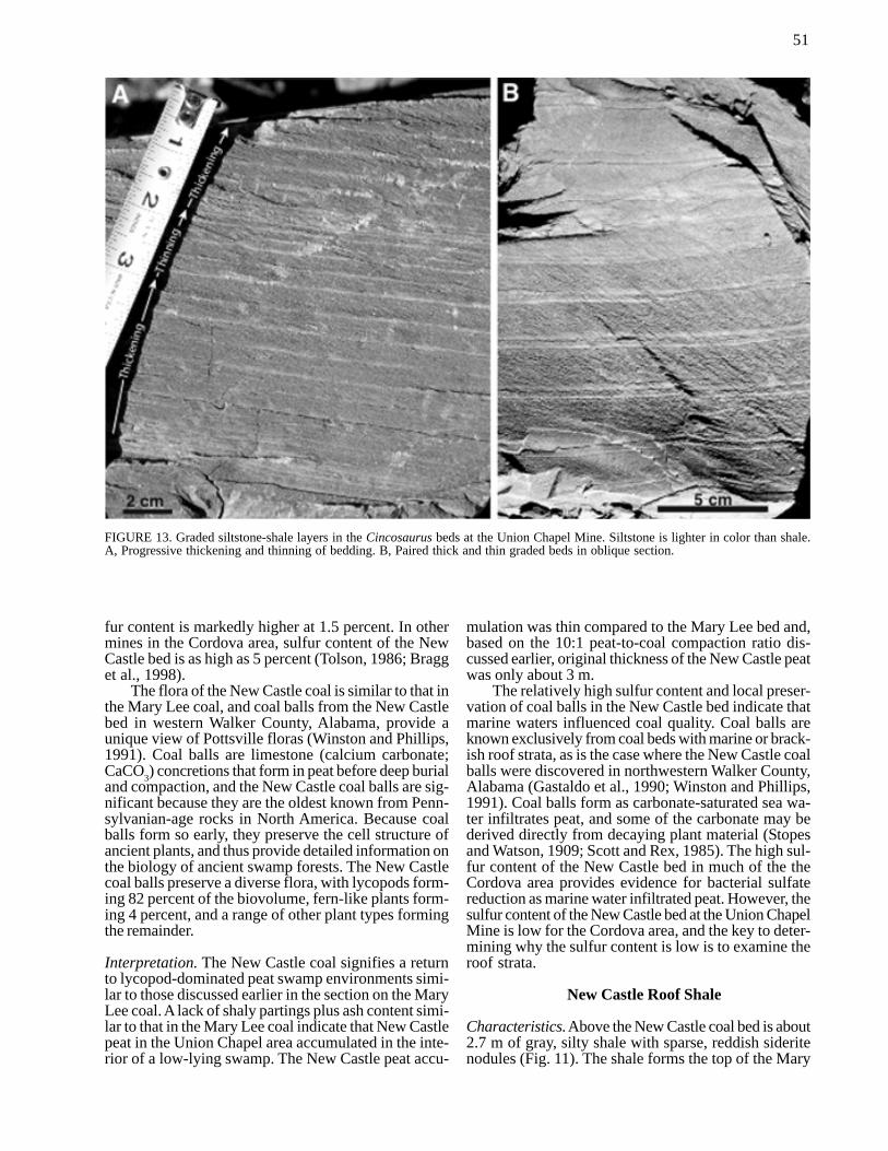
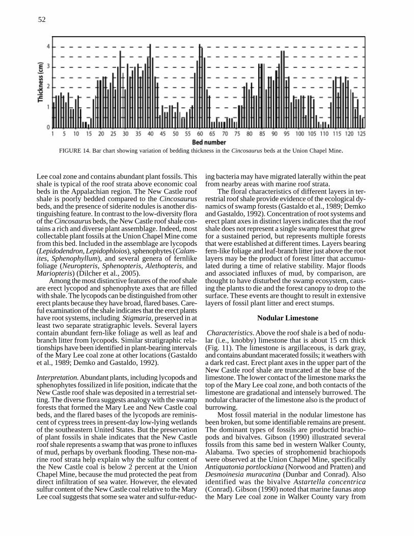
Progressive thickening and thinning of successivegraded beds is common in the Cincosaurus beds (Fig.13A). Locally, thick and thin beds are paired to formcouplets (Fig. 13B). Examination of the highwall indi-cates that the graded beds pinch and swell laterally. Insome areas, siltstone-shale beds thicker than 2 cm thinto less than 0.5 cm in a distance of about 5 m. Broad(>5 m), shallow (<0.3 m) scour surfaces also are com-mon in the Cincosaurus beds. The thickness of 126 suc-cessive beds was measured near the north end of thehighwall, and a bar chart demonstrates progressive thick-ening and thinning of the graded beds (Fig. 14). Althoughthickness changes appear to be largely progressive, the
minima and maxima of layer thickness are irregularlyspaced.
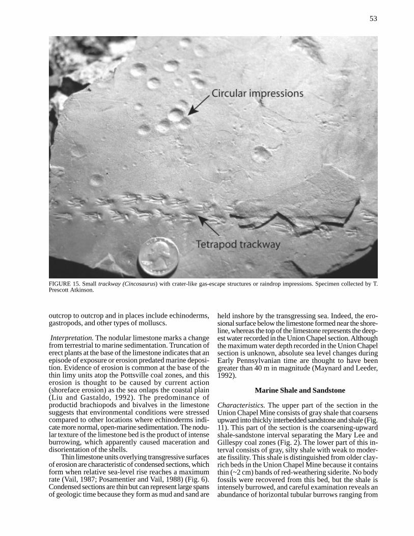
Some types of physical sedimentary structures arecommon in the Cincosaurus beds. Sole markings are onthe bases of some graded siltstone-shale and sandstone-shale beds and include groove casts, prod marks, andload casts. The most distinctive physical structures arecrater-like impressions at the top of the graded shalebeds (Fig. 15). These impressions have variable size andspacing and are characterized by elevated circular rimsaround central depressions.
Several types of trace fossils are preserved withCincosaurus, including probable horseshoe crab traces(Kouphichnium isp.), fish traces (Undichna isp.), in-sect traces (Treptichnus isp.), and millipede traces(Diplichnites isp.). These traces are illustrated in detailin Buta et al. (2005) and have been identified in otherPottsville exposures (Rindsberg, 1990). Macerated plantdebris is common on bedding planes, and most plantfossils in the Cincosaurus beds include fragments offronds and branches derived from seed ferns(Neuropteris sp.) and other fern-like foliage, as well asthe horsetail-like sphenophyte Calamites sp. In the north-ern part of the mine face, an erect seed fern stump wasobserved, and several erect specimens of Calamites havebeen recovered from the spoils.
The upper 2 m of the Cincosaurus beds contrastsharply with the underlying pinstripe-bedded shale thatyielded the trackways (Fig. 11). Above the pinstripe-bedded interval is about 1 m of ripple-bedded (wavyand flaser-bedded) sandstone and shale. The sandstoneis very fine grained and light gray, whereas the shale issilty. Discoid pebbles of shale and siderite are commonin this bed, as are tubular horizontal burrows of un-known affinity. The uppermost meter of the Cincosaurusbeds consists of sandy underclay that fines upward. Sid-erite nodules and root traces are common throughoutthe underclay interval, and some root traces extend down-ward into the ripple-bedded sandstone below. Sideritenodules are distinctive because they are hard and havereddish hues. The root traces are assigned to the genusStigmaria, which is the root system of a variety of lyco-pod types.
Interpretation. The Cincosaurus beds are interpretedas intertidal mudflat deposits (Fig. 11), and these typesof deposits have been known from the Pottsville Forma-tion for many years (Hobday, 1974; Demko andGastaldo, 1996). The Cincosaurus mudflat formed byinundation of the Mary Lee peat swamp with sediment-laden water, and biogenic and physical structures re-veal much about the dynamics of the environment wherethe trackways were preserved. Peat compacts greatlyduring the early stages of burial below mud and sand(Nadon, 1998), so preservation of the Cincosaurus bedsmay reflect accumulation of sediment above compact-ing peat as much as rising water level.
The graded siltstone-shale and sandstone-shale beds(Fig. 13) indicate that sedimentation was episodic. Eachgraded bed represents a single event in which sedimentsettled from suspension in water at the site of deposi-tion. Groove casts and prod marks formed prior to depo-
FIGURE 9. Variation of insolation and ice volume during the Pleis-tocene glaciation (after Berger and Loutre, 1991; Riall, 1999).
48
sition as vigorous currents caused objects to slide orskip on the sediment surface. Load casts, by compari-son, formed later as fluid sediment deformed under theweight of the younger graded beds. Sand and silt settledfirst from suspension as the current slowed, and thelighter clay settled later, thus forming graded beds. Pairedthick and thin graded beds correspond to paired eventsin which the current depositing the thick bed was stron-ger. Such paired depositional events are common in tidalsystems and can represent the deposits of flood (incom-ing) and ebb (outgoing) tides. Evidence for the tidal rangeis not preserved at the Union Chapel Mine, but com-parison of Pottsville strata with modern analogs sug-gests that a mesotidal regime (2-4 m) prevailed duringPottsville deposition (Hobday, 1974; Horne, 1979).
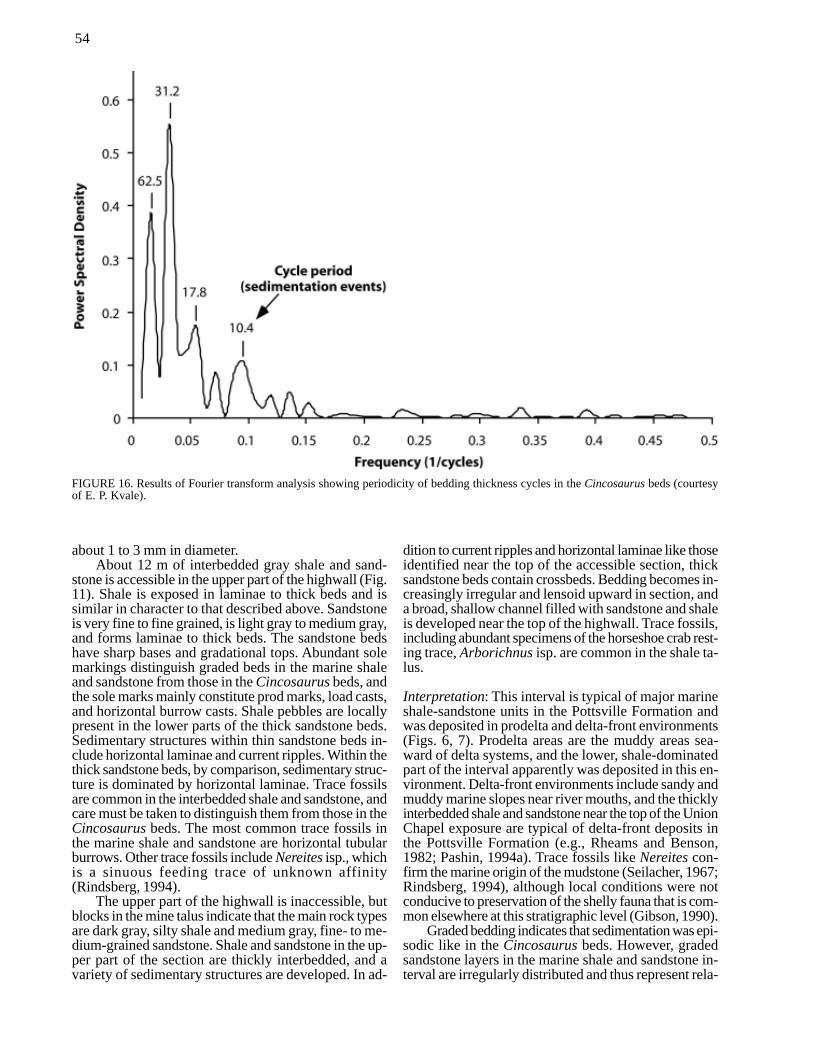
Progressive thickening and thinning of bedding iscommon in Pennsylvanian-age tidal deposits, and analy-sis of bedding thickness patterns has been used to char-acterize monthly (spring-neap) tidal cycles (e.g., Kvaleet al., 1989; Archer, 1991). Pashin et al. (1995) andPashin and Carroll (1999) identified 14-part cycles ofbedding thickness in graded strata resembling theCincosaurus beds in Jefferson County, Alabama. Theysuggested that these cycles are the product of a domi-nantly diurnal lunar tidal regime (one flood daily) andthat each cycle represents 2 weeks. Diurnal systems aretypical of embayments that are restricted from the reso-nance of the open ocean, and this type of tidal systemexists today in the Gulf of Mexico. Statistical analysisof the Cincosaurus beds indicates poor preservation ofspring-neap cyclicity at the Union Chapel Mine (Fig.
16). The dominant periodicity of the thickness cycles is31.2 layers, and subordinate frequencies include 62.5,17.8, and 10.4 layers. These cycle periods suggest thatspring-neap cycles were masked by other depositionalprocesses, and the frequencies of 62.5 and 31.2 mayindicate monthly, seasonal, or even localized changes ofsediment flux. This result is not surprising because bed-ding in the Cincosaurus beds pinches and swells later-ally, and broad scour-and-fill structures provide first-hand evidence for discontinuous sedimentation.
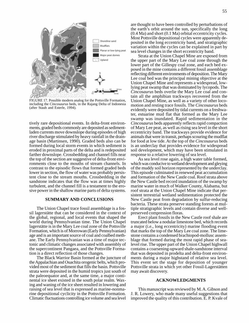
The extremely low sulfur content of the Mary Leecoal bed indicates that the waters that inundated theswamp were fresh and, indeed, modern amphibians haveeffectively no tolerance for saline conditions. Therefore,the Cincosaurus beds can be interpreted as an estuarinemudflat in which tidal currents primarily moved freshwater about. Other fresh-water tidal deposits have beenidentified in the roof of Pennsylvanian-aged coal in In-diana by Kvale and Mastalerz (1998), and estuarinemudflats exist today adjacent to low-ash peat swampson the Rajang Delta in Indonesia (Staub and Esterle,1994) (Fig. 17). Using the Rajang Delta as a modernanalog, sedimentation on the Cincosaurus mudflat mayhave been influenced as strongly by changes in streamlevels and deltaic sediment discharge as by spring-neaptidal cycles.
Interpretation of the craterlike impressions is prob-lematic. These structures resemble raindrop imprints,and if this interpretation is correct, the circular outlinesindicate that the drops fell under low-wind conditions(Reineck, 1955; Shrock, 1948). Raindrop imprints are
FIGURE 10. Idealized relationship of stratigraphic variation within a Pottsville depositional cycle to 0.1 Ma eccentricity cycles (afterPashin et al., 2003).
49
compatible with the rainy, equatorial setting of thePottsville Formation. A lack of mudcracks indicates thatthe mud flat was never exposed long enough for the sedi-ment to desiccate and crack; thus windows of opportu-nity for the formation of raindrop imprints were restrictedto extreme low-tide conditions. However, many of these
structures have irregular outlines or appear stretched,suggesting that an origin as collapsed gas bubbles ismore feasible in many cases (see Rindsberg, 2005). Also,few of the structures overlap, which is atypical of rain-drop imprints, and some of the structures appear to passthrough multiple layers and may, therefore, include an
FIGURE 11. Measured section of the Pottsville Formation at the Union Chapel Mine.
50
enigmatic type of burrow.Calamites and an unidentified seed fern were the
only plants preserved in life position in the Cincosaurusbeds. The mangrove-like root systems of seed ferns (Fig.12) attest to frequent flooding of the mud flat and sug-gest analogy with modern mangrove swamps of themuddy shore zone. Whereas some plants resided on themud flat, the trace fossil assemblage is dominated bylocomotion traces, indicating that most fauna were intransit. One possibility is that during low-water condi-tions, Cincosaurus and other creatures entered the mudflat to forage.
The ripple-bedded sandstone and shale near the topof the Cincosaurus beds also is characteristic of tidalflats (e.g., van Straaten, 1954) and, based on the overalllithologic character of this interval, it can be interpretedas the deposit of a mixed sand-mud flat. Ripple-beddedsandstone indicates deposition by turbulent flow, whereasthe shale represents mud that accumulated during low-flow or slack-water conditions. One possibility is thatthe ripple-bedded sandstone and shale were deposited ina sandier part of the same mudflat complex where theCincosaurus trackways were preserved.
The underclay at the top of the Cincosaurus bedsmarks a transition from tidal flat to swamp environ-ments, thus foreshadowing formation of the overlyingNew Castle coal. Intense rooting in underclay beds pro-vides evidence for formation of an ancient soil horizon,or paleosol. Underclay beds generally are interpreted as
hydromorphic paleosols, which are subaqueous wetlandsoils, but the complete origin of underclay beds is im-precisely known and is controversial (e.g., Gardner etal., 1988; Mack et al., 1993). Most investigators agreethat underclay formation began with a lowered watertable in which iron and other compounds were leachedfrom the upper part of the soil profile. In Pottsvilleunderclay, the leached iron is preserved in the lower partof the ancient soil profile as siderite nodules. As the watertable rises, perhaps in concert with sea level, a swampforest can be established and, as wetland conditions form,peat can begin to accumulate. Alkaline fluid within peatcan react with the sediment below by dissolving quartzand concentrating clay by a process called gleying, whichhelps explain why underclay beds fine upward. Althoughthe underclay at the top of the Cincosaurus beds is siltyand thus weakly gleyed, the underclay below the MaryLee coal is, in places, intensely gleyed and is mined inthe Cordova area for ceramic applications.
New Castle Coal Bed
Characteristics. The New Castle coal is 0.30 m thick atthe Union Chapel Mine and sharply overlies theCincosaurus beds. Like the Mary Lee coal, the NewCastle bed is bright-banded, lacks partings of shale orsandstone, and maintains uniform thickness. The NewCastle bed has heating value (12,000 Btu/lb) and ashcontent (10-16%) similar to the Mary Lee bed, but sul-
FIGURE 12. Reconstructions of common plant fossils in Pennsylvanian-aged coal-bearing strata (after Gillespie et al., 1978).
51
fur content is markedly higher at 1.5 percent. In othermines in the Cordova area, sulfur content of the NewCastle bed is as high as 5 percent (Tolson, 1986; Bragget al., 1998).
The flora of the New Castle coal is similar to that inthe Mary Lee coal, and coal balls from the New Castlebed in western Walker County, Alabama, provide aunique view of Pottsville floras (Winston and Phillips,1991). Coal balls are limestone (calcium carbonate;CaCO3) concretions that form in peat before deep burialand compaction, and the New Castle coal balls are sig-nificant because they are the oldest known from Penn-sylvanian-age rocks in North America. Because coalballs form so early, they preserve the cell structure ofancient plants, and thus provide detailed information onthe biology of ancient swamp forests. The New Castlecoal balls preserve a diverse flora, with lycopods form-ing 82 percent of the biovolume, fern-like plants form-ing 4 percent, and a range of other plant types formingthe remainder.
Interpretation. The New Castle coal signifies a returnto lycopod-dominated peat swamp environments simi-lar to those discussed earlier in the section on the MaryLee coal. A lack of shaly partings plus ash content simi-lar to that in the Mary Lee coal indicate that New Castlepeat in the Union Chapel area accumulated in the inte-rior of a low-lying swamp. The New Castle peat accu-
mulation was thin compared to the Mary Lee bed and,based on the 10:1 peat-to-coal compaction ratio dis-cussed earlier, original thickness of the New Castle peatwas only about 3 m.
The relatively high sulfur content and local preser-vation of coal balls in the New Castle bed indicate thatmarine waters influenced coal quality. Coal balls areknown exclusively from coal beds with marine or brack-ish roof strata, as is the case where the New Castle coalballs were discovered in northwestern Walker County,Alabama (Gastaldo et al., 1990; Winston and Phillips,1991). Coal balls form as carbonate-saturated sea wa-ter infiltrates peat, and some of the carbonate may bederived directly from decaying plant material (Stopesand Watson, 1909; Scott and Rex, 1985). The high sul-fur content of the New Castle bed in much of the theCordova area provides evidence for bacterial sulfatereduction as marine water infiltrated peat. However, thesulfur content of the New Castle bed at the Union ChapelMine is low for the Cordova area, and the key to deter-mining why the sulfur content is low is to examine theroof strata.
New Castle Roof Shale
Characteristics. Above the New Castle coal bed is about2.7 m of gray, silty shale with sparse, reddish sideritenodules (Fig. 11). The shale forms the top of the Mary
FIGURE 13. Graded siltstone-shale layers in the Cincosaurus beds at the Union Chapel Mine. Siltstone is lighter in color than shale.A, Progressive thickening and thinning of bedding. B, Paired thick and thin graded beds in oblique section.
52
Lee coal zone and contains abundant plant fossils. Thisshale is typical of the roof strata above economic coalbeds in the Appalachian region. The New Castle roofshale is poorly bedded compared to the Cincosaurusbeds, and the presence of siderite nodules is another dis-tinguishing feature. In contrast to the low-diversity floraof the Cincosaurus beds, the New Castle roof shale con-tains a rich and diverse plant assemblage. Indeed, mostcollectable plant fossils at the Union Chapel Mine comefrom this bed. Included in the assemblage are lycopods(Lepidodendron, Lepidophloios), sphenophytes (Calam-ites, Sphenophyllum), and several genera of fernlikefoliage (Neuropteris, Sphenopteris, Alethopteris, andMariopteris) (Dilcher et al., 2005).
Among the most distinctive features of the roof shaleare erect lycopod and sphenophyte axes that are filledwith shale. The lycopods can be distinguished from othererect plants because they have broad, flared bases. Care-ful examination of the shale indicates that the erect plantshave root systems, including Stigmaria, preserved in atleast two separate stratigraphic levels. Several layerscontain abundant fern-like foliage as well as leaf andbranch litter from lycopods. Similar stratigraphic rela-tionships have been identified in plant-bearing intervalsof the Mary Lee coal zone at other locations (Gastaldoet al., 1989; Demko and Gastaldo, 1992).
Interpretation. Abundant plants, including lycopods andsphenophytes fossilized in life position, indicate that theNew Castle roof shale was deposited in a terrestrial set-ting. The diverse flora suggests analogy with the swampforests that formed the Mary Lee and New Castle coalbeds, and the flared bases of the lycopods are reminis-cent of cypress trees in present-day low-lying wetlandsof the southeastern United States. But the preservationof plant fossils in shale indicates that the New Castleroof shale represents a swamp that was prone to influxesof mud, perhaps by overbank flooding. These non-ma-rine roof strata help explain why the sulfur content ofthe New Castle coal is below 2 percent at the UnionChapel Mine, because the mud protected the peat fromdirect infiltration of sea water. However, the elevatedsulfur content of the New Castle coal relative to the MaryLee coal suggests that some sea water and sulfur-reduc-
ing bacteria may have migrated laterally within the peatfrom nearby areas with marine roof strata.
The floral characteristics of different layers in ter-restrial roof shale provide evidence of the ecological dy-namics of swamp forests (Gastaldo et al., 1989; Demkoand Gastaldo, 1992). Concentration of root systems anderect plant axes in distinct layers indicates that the roofshale does not represent a single swamp forest that grewfor a sustained period, but represents multiple foreststhat were established at different times. Layers bearingfern-like foliage and leaf-branch litter just above the rootlayers may be the product of forest litter that accumu-lated during a time of relative stability. Major floodsand associated influxes of mud, by comparison, arethought to have disturbed the swamp ecosystem, caus-ing the plants to die and the forest canopy to drop to thesurface. These events are thought to result in extensivelayers of fossil plant litter and erect stumps.
Nodular Limestone
Characteristics. Above the roof shale is a bed of nodu-lar (i.e., knobby) limestone that is about 15 cm thick(Fig. 11). The limestone is argillaceous, is dark gray,and contains abundant macerated fossils; it weathers witha dark red cast. Erect plant axes in the upper part of theNew Castle roof shale are truncated at the base of thelimestone. The lower contact of the limestone marks thetop of the Mary Lee coal zone, and both contacts of thelimestone are gradational and intensely burrowed. Thenodular character of the limestone also is the product ofburrowing.
Most fossil material in the nodular limestone hasbeen broken, but some identifiable remains are present.The dominant types of fossils are productid brachio-pods and bivalves. Gibson (1990) illustrated severalfossils from this same bed in western Walker County,Alabama. Two species of strophomenid brachiopodswere observed at the Union Chapel Mine, specificallyAntiquatonia portlockiana (Norwood and Pratten) andDesmoinesia muracatina (Dunbar and Conrad). Alsoidentified was the bivalve Astartella concentrica(Conrad). Gibson (1990) noted that marine faunas atopthe Mary Lee coal zone in Walker County vary from
FIGURE 14. Bar chart showing variation of bedding thickness in the Cincosaurus beds at the Union Chapel Mine.
53
outcrop to outcrop and in places include echinoderms,gastropods, and other types of molluscs.
Interpretation. The nodular limestone marks a changefrom terrestrial to marine sedimentation. Truncation oferect plants at the base of the limestone indicates that anepisode of exposure or erosion predated marine deposi-tion. Evidence of erosion is common at the base of thethin limy units atop the Pottsville coal zones, and thiserosion is thought to be caused by current action(shoreface erosion) as the sea onlaps the coastal plain(Liu and Gastaldo, 1992). The predominance ofproductid brachiopods and bivalves in the limestonesuggests that environmental conditions were stressedcompared to other locations where echinoderms indi-cate more normal, open-marine sedimentation. The nodu-lar texture of the limestone bed is the product of intenseburrowing, which apparently caused maceration anddisorientation of the shells.
Thin limestone units overlying transgressive surfacesof erosion are characteristic of condensed sections, whichform when relative sea-level rise reaches a maximumrate (Vail, 1987; Posamentier and Vail, 1988) (Fig. 6).Condensed sections are thin but can represent large spansof geologic time because they form as mud and sand are
held inshore by the transgressing sea. Indeed, the ero-sional surface below the limestone formed near the shore-line, whereas the top of the limestone represents the deep-est water recorded in the Union Chapel section. Althoughthe maximum water depth recorded in the Union Chapelsection is unknown, absolute sea level changes duringEarly Pennsylvanian time are thought to have beengreater than 40 m in magnitude (Maynard and Leeder,1992).
Marine Shale and Sandstone
Characteristics. The upper part of the section in theUnion Chapel Mine consists of gray shale that coarsensupward into thickly interbedded sandstone and shale (Fig.11). This part of the section is the coarsening-upwardshale-sandstone interval separating the Mary Lee andGillespy coal zones (Fig. 2). The lower part of this in-terval consists of gray, silty shale with weak to moder-ate fissility. This shale is distinguished from older clay-rich beds in the Union Chapel Mine because it containsthin (~2 cm) bands of red-weathering siderite. No bodyfossils were recovered from this bed, but the shale isintensely burrowed, and careful examination reveals anabundance of horizontal tubular burrows ranging from
FIGURE 15. Small trackway (Cincosaurus) with crater-like gas-escape structures or raindrop impressions. Specimen collected by T.Prescott Atkinson.
54
about 1 to 3 mm in diameter.About 12 m of interbedded gray shale and sand-
stone is accessible in the upper part of the highwall (Fig.11). Shale is exposed in laminae to thick beds and issimilar in character to that described above. Sandstoneis very fine to fine grained, is light gray to medium gray,and forms laminae to thick beds. The sandstone bedshave sharp bases and gradational tops. Abundant solemarkings distinguish graded beds in the marine shaleand sandstone from those in the Cincosaurus beds, andthe sole marks mainly constitute prod marks, load casts,and horizontal burrow casts. Shale pebbles are locallypresent in the lower parts of the thick sandstone beds.Sedimentary structures within thin sandstone beds in-clude horizontal laminae and current ripples. Within thethick sandstone beds, by comparison, sedimentary struc-ture is dominated by horizontal laminae. Trace fossilsare common in the interbedded shale and sandstone, andcare must be taken to distinguish them from those in theCincosaurus beds. The most common trace fossils inthe marine shale and sandstone are horizontal tubularburrows. Other trace fossils include Nereites isp., whichis a sinuous feeding trace of unknown affinity(Rindsberg, 1994).
The upper part of the highwall is inaccessible, butblocks in the mine talus indicate that the main rock typesare dark gray, silty shale and medium gray, fine- to me-dium-grained sandstone. Shale and sandstone in the up-per part of the section are thickly interbedded, and avariety of sedimentary structures are developed. In ad-
dition to current ripples and horizontal laminae like thoseidentified near the top of the accessible section, thicksandstone beds contain crossbeds. Bedding becomes in-creasingly irregular and lensoid upward in section, anda broad, shallow channel filled with sandstone and shaleis developed near the top of the highwall. Trace fossils,including abundant specimens of the horseshoe crab rest-ing trace, Arborichnus isp. are common in the shale ta-lus.
Interpretation: This interval is typical of major marineshale-sandstone units in the Pottsville Formation andwas deposited in prodelta and delta-front environments(Figs. 6, 7). Prodelta areas are the muddy areas sea-ward of delta systems, and the lower, shale-dominatedpart of the interval apparently was deposited in this en-vironment. Delta-front environments include sandy andmuddy marine slopes near river mouths, and the thicklyinterbedded shale and sandstone near the top of the UnionChapel exposure are typical of delta-front deposits inthe Pottsville Formation (e.g., Rheams and Benson,1982; Pashin, 1994a). Trace fossils like Nereites con-firm the marine origin of the mudstone (Seilacher, 1967;Rindsberg, 1994), although local conditions were notconducive to preservation of the shelly fauna that is com-mon elsewhere at this stratigraphic level (Gibson, 1990).
Graded bedding indicates that sedimentation was epi-sodic like in the Cincosaurus beds. However, gradedsandstone layers in the marine shale and sandstone in-terval are irregularly distributed and thus represent rela-
FIGURE 16. Results of Fourier transform analysis showing periodicity of bedding thickness cycles in the Cincosaurus beds (courtesyof E. P. Kvale).
55
tively rare depositional events. In delta-front environ-ments, graded beds commonly are deposited as sediment-laden currents move downslope during episodes of highriver discharge stimulated by heavy rainfall in the drain-age basin (Martinsen, 1990). Graded beds also can beformed during local storm events in which sediment iseroded in proximal parts of the delta and is redepositedfarther downslope. Crossbedding and channel fills nearthe top of the section are suggestive of delta-front envi-ronments close to the mouths of stream channels. Incontrast to the episodic flows that formed graded bedslower in section, the flow of water was probably persis-tent close to the stream mouths. Crossbedding in thesandstone indicates that the flow was at times highlyturbulent, and the channel fill is a testament to the ero-sive power in the shallow marine parts of delta systems.
SUMMARY AND CONCLUSIONS
The Union Chapel trace fossil assemblage is a fos-sil lagerstätte that can be considered in the context ofthe global, regional, and local events that shaped theworld during Pennsylvanian time. The Union Chapellagerstätte is in the Mary Lee coal zone of the PottsvilleFormation, which is of Morrowan (Early Pennsylvanian)age and is an important source of coal and coalbed meth-ane. The Early Pennsylvanian was a time of major tec-tonic and climatic changes associated with assembly ofthe supercontinent Pangaea, and the Pottsville Forma-tion is a direct reflection of those changes.
The Black Warrior Basin formed at the juncture ofthe Appalachian and Ouachita orogenic belts, which pro-vided most of the sediment that fills the basin. Pottsvillestrata were deposited in the humid tropics just south ofthe paleoequator and, at the same time, a major conti-nental ice sheet existed in the south polar realm. Wax-ing and waning of the ice sheet resulted in lowering andraising of sea level that is expressed as marine-nonma-rine depositional cyclicity in the Pottsville Formation.Climatic fluctuations controlling ice volume and sea level
are thought to have been controlled by perturbations ofthe earth’s orbit around the sun, specifically the long(0.4 Ma) and short (0.1 Ma) orbital eccentricity cycles.Most Pottsville depositional cycles were apparently de-posited in the long eccentricity band, and stratigraphicvariation within the cycles can be explained in part bysea level changes in the short eccentricity band.
Strata at the Union Chapel Mine are exposed fromthe upper part of the Mary Lee coal zone through thelower part of the Gillespy coal zone, and each bed ex-posed in the mine contains a different fossil assemblagereflecting different environments of deposition. The MaryLee coal bed was the principal mining objective at theUnion Chapel Mine and represents a widespread, low-lying peat swamp that was dominated by lycopods. TheCincosaurus beds overlie the Mary Lee coal and con-tain all the amphibian trackways recovered from theUnion Chapel Mine, as well as a variety of other loco-motion and resting trace fossils. The Cincosaurus bedsevidently were deposited by tidal currents on a freshwa-ter, estuarine mud flat that formed as the Mary Leeswamp was inundated. Rapid sedimentation in theCincosaurus beds apparently reflects rapid compactionof Mary Lee peat, as well as rising sea level in the shorteccentricity band. The trackways provide evidence foranimals that were in transit, perhaps scouring the mudflatfor food at low tide. At the top of the Cincosaurus bedsis an underclay that provides evidence for widespreadsoil development, which may have been stimulated inresponse to a relative lowering of sea level.
As sea level rose again, a high water table formed,which was conducive to wetland development and gleyingof the muddy soil horizon represented by the underclay.This episode culminated in renewed peat accumulationand formation of the New Castle coal. Roof strata abovethe New Castle bed record inundation of the swamp bymarine water in much of Walker County, Alabama, butroof strata at the Union Chapel Mine indicate that per-sistent terrestrial wetland sedimentation protected theNew Castle peat from degradation by sulfur-reducingbacteria. These strata preserve standing forests at mul-tiple stratigraphic levels and contain diverse and well-preserved compression floras.
Erect plant fossils in the New Castle roof shale aretruncated below a nodular limestone bed, which recordsa major (i.e., long eccentricity) marine flooding eventthat marks the top of the Mary Lee coal zone. The lime-stone contains a condensed brachiopod-mollusc assem-blage that formed during the most rapid phase of sea-level rise. The upper part of the Union Chapel highwallcontains a coarsening-upward shale-sandstone intervalthat was deposited in prodelta and delta-front environ-ments during a major highstand of relative sea level.This event set the stage for deposition of youngerPottsville strata in which yet other Fossil-Lagerstättenmay await discovery.
ACKNOWLEDGMENTS
This manuscript was reviewed by M. A. Gibson andJ. R. Lowery, who made many useful suggestions thatimproved the quality of this contribution. E. P. Kvale of
FIGURE 17. Possible modern analog for the Pottsville Formation,including the Cincosaurus beds, in the Rajang Delta of Indonesia(after Staub and Esterle, 1994).
56
the Indiana Geological Survey kindly performed a Fou-rier transform analysis of bedding in the Cincosaurusbeds using the maximum entropy method.
REFERENCES
Aldrich, T. H., Sr. and Jones, W. B., 1930, Footprints from thecoal measures of Alabama: Alabama Museum of Natural His-tory, Museum Paper 9, 64 p.
Anderson, J. A. R., 1964, Structure and development of the peatswamps of Sarawak and Brunei: Journal of Tropical Geogra-phy, v. 18, p. 7-16.
Archer, A. W., 1991, Modeling of tidal rhythmites using moderntidal periodicities and implications for short-term sedimen-tation rates: Kansas Geological Survey Bulletin, no. 233, p.185-194.
Berger, A. L., and Loutre, M. F., 1991, Insolation values for theclimate of the last 10 million years: Quaternary Science Re-view, v. 10, p. 297-317.
Bragg, L. J., Oman, J. K., Tewalt, S. J., Oman, C. L., Rega, N. H.,Washington, P. M., and Finkelman, R. B., 1998, U.S. Geo-logical Survey coal quality database (COALQUAL), version2.0: U.S. Geological Survey Open-File Report 97-134 (CD-ROM).
Buta, R. J., Kopaska-Merkel, D. C., Rindsberg, A. K., and Mar-tin, A. J., 2005, Atlas of Union Chapel Mine invertebratetrackways and other traces; in Buta, R. J., Rindsberg, A. K.and Kopaska-Merkel, D. C., eds., Pennsylvanian Footprintsin the Black Warrior Basin of Alabama: Alabama Paleonto-logical Society Monograph no. 1, p. 277-337.
Butts, C., 1910, Description of the Birmingham Quadrangle, Ala-bama: U.S. Geological Survey Geologic Atlas of the UnitedStates, Folio 175, 24 p.
Butts, C., 1926, The Paleozoic rocks; in Adams, G. I., Butts, C.,Stephenson, L. W. and Cooke, C. W., Geology of Alabama:Alabama Geological Survey Special Report 14, p. 41-230.
Caputo, M. V. and Crowell, J. C., 1985, Migration of glacial cen-ters across Gondwana during Paleozoic Era: Geological So-ciety of America Bulletin, v. 96, p. 1020-1036.
Carroll, R. E., 1997, Alabama coal data for 1994: Alabama Geo-logical Survey Information Series 58P, 132 p.
Carroll, R. E., Pashin, J. C. and Kugler, R. L., 1995, Burial his-tory and source-rock characteristics of Upper Devonianthrough Pennsylvanian strata, Black Warrior basin, Alabama:Alabama Geological Survey Circular 187, 29 p.
Casagrande, D. J., 1987, Sulphur in peat and coal; in Scott, A. C.,ed., Coal and coal-bearing strata: recent advances: Geologi-cal Society of London Special Publication no. 32, p. 87-105.
Cecil, C. B., 1990, Paleoclimate controls on stratigraphic repeti-tion of chemical and siliciclastic rocks: Geology, v. 18, p.533-536.
Cobb, J. C., Chesnut, D. R., Hester, N. C. and Hower, J. C., 1981,Coal and coal-bearing rocks of eastern Kentucky. Lexington,Kentucky, Kentucky Geological Survey, Annual GeologicalSociety of America Coal Division Field Trip Guidebook, 169p.
Cohen, A. D., 1974, Petrography and paleoecology of Holocenepeats from the Okefenokeee swamp-marsh complex of Geor-gia: Journal of Sedimentary Petrology, v. 44, p. 716-726.
Culbertson, W. C., 1964, Geology and coal resources of the coal-bearing rocks of Alabama: U.S. Geological Survey Bulletin1182-B, 79 p.
Demko, T. M. and Gastaldo, R. A., 1992, Paludal environments ofthe Lower Mary Lee coal zone, Pottsville Formation, Ala-bama: Stacked clastic swamps and peat mires: InternationalJournal of Coal Geology, v. 20, p. 23-47.
Demko, T. M. and Gastaldo, R. A., 1996, Eustatic and autocyclic
influences on deposition of the Lower Pennsylvanian MaryLee coal zone, Warrior Basin, Alabama: International Jour-nal of Coal Geology, v. 31, p. 3-19.
Eble, C. F., Gastaldo, R. A., Demko, T. M., and Liu, Y., 1994,Coal compositional changes along a swamp interior to swampmargin transect in the Mary Lee Coal bed, Warrior Basin,Alabama, U.S.A: International Journal of Coal Geology, v.26, p. 43-62.
Eble, C. F. and Gillespie, W. H., 1989, Palynology of selected coalbeds from the central and southern Appalachian basin: corre-lation and stratigraphic implications: Washington, D.C., 28thInternational Geological Congress, Guidebook T352, p. 61-66.
Eble, C. F., Gillespie, W. H. and Henry, T. W., 1991, Palynology,paleobotany, and invertebrate paleontology of Pennsylvaniancoal beds and associated strata in the Warrior and Cahabacoal fields; in Thomas, W.A., and Osborne, W. E., eds., Mis-sissippian-Pennsylvanian tectonic history of the Cahabasynclinorium: Alabama Geological Society Guidebook, 28thAnnual Field Trip, p. 119-132.
Elder, C. H. and Deul, M., 1974, Degasification of the Mary Leecoalbed near Oak Grove, Jefferson County, Alabama, by ver-tical borehole in advance of mining: U.S. Bureau of MinesReport of Investigations 7968, 21 p.
Ferm, J. C., Ehrlich, R. and Neathery, T. L., 1967, A field guide toCarboniferous detrital rocks in northern Alabama: Geologi-cal Society of America, 1967 Coal Division Field Trip Guide-book, 101 p.
Ferm, J. C. and Weisenfluh, G. A., 1989, Evolution of some depo-sitional models in Late Carboniferous rocks of the Appala-chian coal fields: International Journal of Coal Geology, v.12, p. 259-292.
Frakes, L. A., Francis, J. E. and Syktus, J. I., 1992, Climate modesof the Phanerozoic. Cambridge, Cambridge Press, 274 p.
Galloway, W. E., 1989, Genetic stratigraphic sequences in basinanalysis I: architecture and genesis of flooding-surfacebounded depositional units: American Association of Petro-leum Geologists Bulletin, v. 73, p. 125-142.
Gardner, T. W., Williams, E. G. and Holbrook, P. W., 1988, Pedo-genesis of some Pennsylvanian underclays: ground-water,topographic, and tectonic controls: Geological Society ofAmerica, Special Paper, no. 216, p. 81-101.
Gastaldo, R. A., Demko, T. M., and Liu, Y. eds., 1990, Carbonif-erous coastal environments and paleocommunities of the MaryLee coal zone, Marion and Walker Counties, Alabama: Ala-bama Geological Survey Guidebook Series VI, 139 p.
Gastaldo, R. A., Demko, T. M. and Liu, Y., 1993, Application ofsequence and genetic stratigraphic concepts to Carbonifer-ous coal-bearing strata: an example from the Black WarriorBasin, USA: Geologische Rundschau, v. 82, p. 212-226.
Gastaldo, R. A., Demko, T. M., Liu, Y., Keefer, W. D., and Abston,S. L., 1989, Biostratinomic processes for the development ofmud-cast logs in Carboniferous and Holocene swamps:Palaios, v. 4, p. 356-365.
Gentzis, T., 2000, Subsurface sequestration of carbon dioxideùanoverview from an Alberta (Canada) perspective: InternationalJournal of Coal Geology, v. 43, p. 287-305.
Gibson, M. A., 1990, Common macroinvertebrates associated withthe Mary Lee coal zone (Pennsylvanian, upper Pottsville For-mation), northern Alabama; in Gastaldo, R. A., Demko, T.M., and Liu, Y., eds., Carboniferous coastal environmentsand paleocommunities of the Mary Lee coal zone, Marionand Walker Counties, Alabama: Alabama Geological SurveyGuidebook Series VI, p. 97-104.
Gillespie, W. H., Clendening, J. A. and Pfefferkorn, H. W., 1978,Plant fossils of West Virginia: West Virginia Geological andEconomic Survey Educational Series, ED-3A, 172 p.
Heckel, P. H., 1986, Sea-level curve for Pennsylvanian eustatic
57
transgressive-regressive depositional cycles alongmidcontinent outcrop belt, North America: Geology, v. 14, p.330-334.
Heckel, P. H., 1994, Evaluation of evidence for glacio-eustaticcontrol over marine Pennsylvanian cyclothems in NorthAmerica and consideration of possible tectonic effects; inDennison, J. M., and Ettensohn, F. R. eds., Tectonic andEustatic Controls on Sedimentary Cycles: Society for sedi-mentology, Concepts in Sedimentology and Paleontology, no.4, p. 89-105.
Hewitt, J. L., 1984, Geologic overview, coal, and coal bed meth-ane resources of the Warrior basin — Alabama and Missis-sippi; in Rightmire, C. T., Eddy, G. E., and Kirr, J. N., eds.,Coal bed methane resources of the United States: AmericanAssociation of Petroleum Geologists, Studies in Geology, no.17, p. 73-104.
Hobday, D. K., 1974, Beach and barrier island facies in the UpperCarboniferous of northern Alabama: Geological Society ofAmerica Special Paper, no. 148, p. 209-224.
Horne, J. C., 1979, The effects of Carboniferous shoreline geom-etry on paleocurrent distribution; in Ferm, J. C. and Horne, J.C., eds., Carboniferous depositional environments in theAppalachian region: Carolina Coal Group, University of SouthCarolina, Columbia, South Carolina, p. 509-516.
Horsey, C. A., 1981, Depositional environments of the Pennsylva-nian Pottsville Formation in the Black Warrior basin of Ala-bama: Journal of Sedimentary Petrology, v. 51, p. 799-806.
Imbrie, J., 1985, A theoretical framework for the Pleistocene iceages: Journal of the Geological Society of London, v. 142, p.417-432.
Imbrie, J. and Imbrie, J. Z., 1980, Modeling the climatic responseto orbital variations: Science, v. 207, p. 943-953.
Klein, G. deV., 1977, Clastic Tidal Facies: Dordrecht, D. ReidelPublishing, 119 p.
Kvale, E. P., Archer, A. W. and Johnson, H. R., 1989, Daily,monthly, and yearly tidal cycles within laminated siltstonesof the Mansfield Formation (Pennsylvanian) of Indiana: Ge-ology, v. 17, p. 365-368.
Kvale, E. P. and Mastalerz, M., 1998, Evidence of ancient fresh-water tidal deposits; in Alexander, C. R., Davis, R. A., andHenry, V. J., eds., Tidalites: Processes and Products: Societyfor Sedimentology Special Publication, no. 61, p. 95-107.
Lahee, F. H., 1961, Field geology (6th edition): New York, McGrawHill, 926 p.
Liu, Y. and Gastaldo, R. A., 1992, Characteristics of a Pennsylva-nian ravinement surface: Sedimentary Geology, v. 77, p. 197-213.
Mack, G. H., James, W. C. and Monger, H. C., 1993, Classifica-tion of paleosols: Geological Society of America Bulletin, v.105, p. 129-136.
Martinsen, O. J., 1990, Fluvial, inertia-dominated deltaic deposi-tion in the Namurian (Carboniferous) of northern England:Sedimentology, v. 37, p. 1099-1113.
Maynard, J. R. and Leeder, M. R., 1992, On the periodicity andmagnitude of Late Carboniferous glacio-eustatic sea-levelchanges: Journal of the Geological Society of London, v. 149,p. 303-311.
McCabe, P. J., 1984, Depositional environments of coal and coal-bearing strata; in Rahmani, R. A., and Flores, R. M., eds.,Sedimentology of coal and coal-bearing strata: InternationalAssociation of Sedimentologists Special Publication, no. 7,p. 13-42
McCalley, H., 1886, On the Warrior coal field: Alabama Geologi-cal Survey Special Report 1, 571 p.
McCalley, H., 1900, Report on the Warrior coal basin: AlabamaGeological Survey Special Report 10, 327 p.
McFall, K. S., Wicks, D. E., and Kuuskraa, V. A., 1986, A geo-logical assessment of natural gas from coal seams in the War-
rior basin, Alabama — topical report (September 1985-Sep-tember 1986). Lewin and Associates, Inc., Washington, D.C., Gas Research Institute contract no. 5084-214-1066, 80 p.
Mellen, F. F., 1947, Black Warrior basin, Alabama and Missis-sippi: American Association of Petroleum Geologists Bulle-tin, v. 31, p. 1801-1816.
Metzger, W. J., 1965, Pennsylvanian stratigraphy of the Warriorbasin, Alabama: Alabama Geological Survey Circular 30, 80p.
Nadon, G. C., 1998, Magnitude and timing of peat-to-coal com-paction: Geology, v. 26, p. 727-730.
Pashin, J. C., 1994a, Cycles and stacking patterns in Carbonifer-ous rocks of the Black Warrior foreland basin: Gulf CoastAssociation of Geological Societies, Transactions, v. 44, p.555-563.
Pashin, J. C., 1994b, Flexurally influenced eustatic cycles in thePottsville Formation (Lower Pennsylvanian), Black Warriorbasin, Alabama; in Dennison, J. M. and Ettensohn, F. R.eds., Tectonic and Eustatic Controls on Sedimentary Cycles:Society for Sedimentology, Concepts in Sedimentology andPaleontology, no. 4, p. 89-105.
Pashin, J. C., 1994c, Coal-body geometry and synsedimentary de-tachment folding in Oak Grove coalbed-methane field, BlackWarrior basin, Alabama: American Association of PetroleumGeologists Bulletin, v. 78, p. 960-980.
Pashin, J. C., 1998, Stratigraphy and structure of coalbed methanereservoirs in the United States: an overview: InternationalJournal of Coal Geology, v. 35, p. 207-238.
Pashin J. C. and Carroll, R. E., eds., 1998, Geology of the Cahabacoalfield: Alabama Geological Society, 36th Annual Field TripGuidebook, 98 p.
Pashin, J. C., Carroll, R. E., Barnett, R. L. and Beg, M. A., 1995,Geology and coal resources of the Cahaba coal field: Ala-bama Geological Survey Bulletin 163, 49 p.
Pashin, J. C., Carroll, R. E., Groshong, R. H., Jr., Raymond, D. E.,McIntyre, M. and Payton, W. J., 2003, Geologic screeningcriteria for sequestration of CO2 in coal: quantifying potentialof the Black Warrior coalbed methane fairway, Alabama: An-nual Technical Progress Report, U.S. Department of Energy,National Technology Laboratory, contract DE-FC-00NT40927,190 p.
Pashin, J. C., Groshong, R. H., Jr. and Carroll, R. E., 2001, Car-bon sequestration potential of coalbed methane reservoirs inthe Black Warrior basin: a preliminary look. Tuscaloosa, Ala-bama, University of Alabama, College of Continuing Stud-ies, 2001 International Coalbed Methane Symposium, Pro-ceedings, p. 51-62.
Pashin, J. C. and Hinkle, F., 1997, Coal bed methane in Alabama.Alabama Geological Survey Circular 192, 71 p.
Pashin, J. C., Ward, W. E., II, Winston, R. B., Chandler, R. V.,Bolin, D. E., Richter, K. E., Osborne, W. E. and Sarnecki, J.,C. 1991, Regional analysis of the Black Creek-Cobb coalbed-methane target interval, Black Warrior basin, Alabama: Ala-bama Geological Survey Bulletin 145, 127 p.
Posamentier, H. W. and Vail, P. R., 1988, Eustatic controls onclastic deposition, II. Sequence and systems tract models: So-ciety of Economic Paleontologists and Mineralogists SpecialPublication, no. 42, p. 125-154.
Reichle, D., Houghton, J., Kane, B. and Ekmann, J., 1999, Car-bon sequestration: State of the science. U.S. Department ofEnergy, Offices of Science and Fossil Energy, unpaginatedPDF document.
Reineck, H.-E., 1955, Marken, Spuren, und Fährten in denWaderner Schichten (ro) bei Martinstein/Nahe: NeuesJahrbuch fur Geologie und Paläontologie, Abhandlungen, v.101, p. 75-90.
Renton, J. J. and Cecil, C. B., 1979, The origin of mineral matterin coal; in Donaldson, A. C., Presley, M. W., and Renton, J.
58
J., eds., Carboniferous Coal Guidebook, v. 1: West VirginiaGeologic and Economic Survey Bulletin 37-1, p. 206-233.
Rheams, L. J. and Benson, D. J., 1982, Depositional setting of thePottsville Formation in the Black Warrior basin: AlabamaGeological Society 19th Annual Field Trip Guidebook, 94 p.
Rial, J. A., 1999, Pacemaking the ice ages by frequency modula-tion of Earth’s orbital eccentricity: Science, v. 285, p. 564-568.
Rindsberg, A. K., 1990, Freshwater to marine trace fossils of theMary Lee coal zone and overlying strata (Westphalian A),Pottsville Formation of northern Alabama; in Gastaldo, R.A., Demko, T. M., and Liu, Y., eds., Carboniferous coastalenvironments and paleocommunities of the Mary Lee coalzone, Marion and Walker Counties, Alabama: Alabama Geo-logical Survey Guidebook Series VI, p. 82-95.
Rindsberg, A. K., 1994, Ichnology of the Upper MississippianHartselle Sandstone of Alabama, with notes on other Car-boniferous formations: Alabama Geological Survey Bulletin158, 107 p.
Scotese, C. R., 1990, Atlas of Phanerozoic plate tectonic recon-structions: International Lithosphere Program (IUGG-IUGS),Paleomap Project Technical Report 10-90-1, 54 p.
Scotese, C. R., Golonka, J., and Ross, M .I., 1994, Phanerozoicpaleogeographic and paleoclimatic modeling maps; in Embry,A. F., Beauchamp, B. and Glass, D. J., eds., Pangea, globalenvironments and resources: Canadian Society of PetroleumGeologists, Memoir, no. 17, p. 1-47.
Scott, A. C. and Rex, G., 1985, The formation and significance ofCarboniferous coal balls: Philosophical Transactions of theRoyal Society of London, v. 311B, p. 123-137.
Seilacher, A., 1967, Bathymetry of trace fossils: Marine Geology,v. 5, p. 413-428.
Seilacher, A., 1990, Taphonomy of Fossil-Lagerstätten; in Briggs,D. E. G. and Crowther, P. R., eds., Palaeobiology: a synthe-sis. London, Blackwell, p. 266-270.
Sestak, H. M., 1984, Stratigraphy and depositional environmentsof the Pennsylvanian Pottsville Formation in the Black War-rior basin, Alabama and Mississippi: Tuscaloosa, Universityof Alabama, M. S. Thesis, 184 p.
Shrock, R. R., 1948, Sequence in layered rocks. New York,McGraw-Hill, 507 p.
Spears, D. A., 1987, Mineral matter in coals, with special refer-ence to the Pennine Coalfields; in Scott, A. C., (ed.), Coaland coal-bearing strata: recent advances: Geological Societyof London Special Publication, no. 32, p. 171-185.
Staub, J. R. and Esterle, J. S., 1994, Peat-accumulating deposi-tional systems of Sarawak, eastern Malaysia: SedimentaryGeology, v. 89, p. 91-106.
Stopes, M. C. and Watson, D. M. S., 1909, On the present distri-bution and origin of the calcareous concretions in coal seams,known as coal balls: Philosophical Transactions of the RoyalSociety of London, ser. B, v. 200, p. 167-218.
Telle, W. R., Thompson, D. A., Lottman, L. K. and Malone, P. G.,1987, Preliminary burial-thermal history investigations of theBlack Warrior basin: implications for coal bed methane andconventional hydrocarbon development: Tuscaloosa, Univer-sity of Alabama, College of Continuing Studies, 1987 CoalbedMethane Symposium Proceedings, p. 37-50.
Thomas, W. A., 1974, Converging clastic wedges in the Missis-sippian of Alabama: Geological Society of America, SpecialPaper, no. 148, p. 187-207.
Thomas, W. A., 1976, Evolution of the Appalachian-Ouachita con-tinental margin: Journal of Geology, v. 84, p. 323-342.
Thomas, W. A., 1977, Evolution of Appalachian-Ouachita salientsand recesses from reentrants and promontories in the conti-nental margin: American Journal of Science, v. 277, p. 1233-1278.
Thomas, W. A., 1985, The Appalachian-Ouachita connection: Pa-
leozoic orogenic belt at the southern margin of North America:Annual Reviews of Earth and Planetary Sciences, v. 13, p.175-199.
Thomas, W. A., 1988, The Black Warrior Basin; in Sloss, L. L.,ed., Sedimentary cover — North American craton: Geologi-cal Society of America, The Geology of North America, v. D-2, p. 471-492.
Thomas, W. A. and Womack, S. H., 1983, Coal stratigraphy of thedeeper part of the Black Warrior Basin in Alabama: Gulf CoastAssociation of Geological Societies, Transactions, v. 33, p.439-446.
Tolson, J. S., 1986, Coal occurrence and general geology in theCordova 7.5-Minute Quadrangle, Walker County, Alabama:Alabama Geological Survey Open File Report, 15 p.
Vail, P. R., 1987, Seismic stratigraphy interpretation procedure:American Association of Petroleum Geologists Studies inGeology, no. 27 (1), p. 1-10.
van Straaten, L. J. M. U., 1954, Sedimentology of Recent tidal flatdeposits and the Psammites du Condroz (Devonian): Geologieen Mijnbouw, v. 15, p. 1-11.
Wanless, H. R. and Shepard, F. P., 1936, Sea level and climaticchanges related to late Paleozoic cycles: Geological Societyof America Bulletin, v. 47, p. 1177-1206.
Ward, W. E., II, 1984, Reserve base of bituminous coal and lignitein Alabama: Alabama Geological Survey Circular 118, 102 p.
Weller, S., 1930, Cyclic sedimentation of the Pennsylvanian Pe-riod and its significance: Journal of Geology, v. 38, p. 97-135.
Williams, E. G. and Keith, M. L., 1963, Relationship betweensulfur in coals and the occurrence of marine roof beds: Eco-nomic Geology, v. 58, p. 720-729.
Winston, R. B., 1990, Coal-paleobotany of the Mary Lee coal bedof the Pennsylvanian Pottsville Formation near Carbon Hill,Walker County, Alabama; in Gastaldo, R. A., Demko, T. M.and Liu, Y., eds., Carboniferous coastal environments andpaleocommunities of the Mary Lee coal zone, Marion andWalker Counties, Alabama: Alabama Geological SurveyGuidebook Series VI, p. 55-64.
Winston, R. B. and Phillips, T. L., 1991, A structurally preserved,Lower Pennsylvanian flora from the New Castle coal bed ofAlabama: Alabama Geological Survey Circular 157, 21 p.
AUTHOR’S E-MAIL ADDRESS