Embed Size (px)
Citation preview
PRECAMBRIAN GEOLOGIC MAPS OF THE BRADSHAW MOUNTAINS, CENTRAL ARIZONA
BY PHILLIP ANDERSON, PH.D., PRECAMBRIAN SPECIALIST
Introduction
This map folio contains copies of eleven 7.5' geologic quadrangle maps
of central Arizona, -showing the Precambrian geology of each quadrangle map, as
mapped by Phillip Anderson, between 1973 and 1985.
From north to south, the maps in this folio are as follows:
1. Precambrian Geology of the Prescott quadrangle
2. Precambrian Geology of the Prescott Valley South quadrangle
3. Precambrian Geology of the Groom Creek quadrangle
4. Precambrian Geology of the Poland Junction quadrangle
5. Precambrian Geology of the Mayer quadrangle
6. Precambrian Geology of the Battleship Butte quadrangle
7. Precambrian Geology of the Battle Flat quadrangle
8. Precambrian Geology of the Cleator quadrangle
9. Precambrian Geology of the Crown King quadrangle
10. Precambrian Geology of the Bumble Bee quadrangle
11. Precambrian Geology of the Black Canyon City quadrangle.
Confidentiality and Copyright
All data shown on the maps are original geologic mapping by the author,
all are copyrighted, are highly confidential, and are for limited distribution
only to those recipients selected by, and registered with, the corporate offices
of The Precambrian Research Institute, 810 Owens Lane, Payson, Arizona, 85541.
Any person or corporation not registered with The Precambrian Research
Institute, who possesses copies of these maps, or copies all or part of them
without written permission from the author, Phillip Anderson, is in infringement
of this confidentiality stipulation, and of the copyright laws of the Copyright
Office, Library of Congress, Washington, D.C., and is subject to prosecution. . ,
1
Geologic Data
All geologic data is original data which was collected by the author in
the field, and is not derived by compilation of previously-published or unpublished
information. One minor exception is a dotted geologic contact on the Battle Flat
quadrangle labelled from "DeWitt, 1976" (Precambrian geology and ore deposits of the
Mayer-Crown King area, Yavapai County, Arizona; M.S. thesis, University of Arizona,
150 p.), shown for comparison to the author's geologic mapping of the same area.
The eleven geologic maps fully describe the spatial array of original
volcanic, volcaniclastic, clastic, subvolcanic, and plutonic Precambrian rock types
in the central Bradshaw Mountains, as interpreted by the author through a later
Precambrian metamorphic overprint which varies from greenschist to amphibolite
facies throughout the entire region. Rock units above middle amphibolite facies
are shown by their present metamorphic lithology, rather than original protoliths.
All Precambrian rocks shown on the maps evolved in the time span from
1800 to 1700 million years ago, during the early to middle Proterozoic era, and
predate middle to late Proterozoic Apache Group strata in Arizona, which are not
found in the map areas. All younger rocks are shown by the letter "C" (for cover).
Volcanic and clastic strata of the region have been variably deformed
during major Porterozoic orogeny in central Arizona 1700 million years ago, and
early pre-tectonic plutons have experienced similar deformation. Strain varies
from weak in the western part of the Bradshaw Mountains, to moderate and strong in
the central parts, to extreme in the Shylock tectonic zone, which extends down the
centers of the Mayer, Cleator, Bumble Bee, and Black Canyon City quadrangles.
On the following pages is a complete explanation of all geologic symbols
and rock-type abbreviations shown on the maps. Most of these abbreviations follow
standard usage among geologists. The main volcanic protolithic rock types are
identified by capital letters, whereas plutonic and sedimentary rocks are shown in
lower case letters. Rock-type modifiers either before or after the main rock-type
name are shown in lower case letters. All original rock type designations have
been confirmed by the author with major-element chemical and thin section analyses.
Stratigraphic relations have been worked out in detail throughout the region.
2
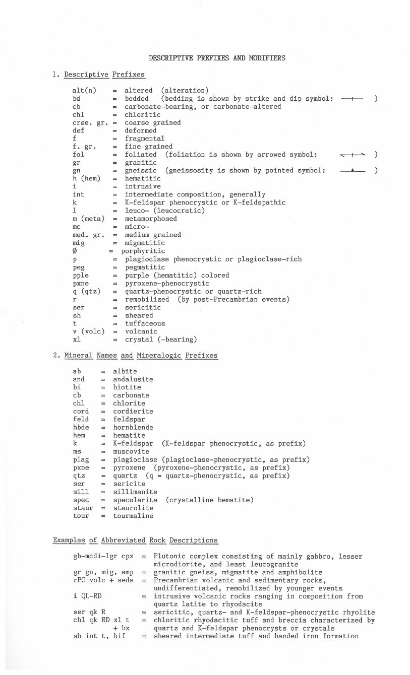
DESCRIPTIVE PREFIXES AND MODIFIERS
1. Descriptive Prefixes
alt(n) bd cb chI crse. gr. def f f. gr.
= = = =
= = =
altered (alteration) bedded (bedding is shown by strike and dip symbol: carbonate-bearing, or carbonate-altered chloritic coarse grained deformed fragmental fine grained
)
fol = foliated (foliation is shown by arrowed symbol: ~<--+----::a..'> )
gr gn h (hem) i int k 1 m (meta) mc med. gr. mig o p peg pple pxne q (qtz) r ser sh t v (volc) xl
=
= = = =
granitic gneissic (gneissosity is shown by pointed symbol: hematitic intrusive intermediate composition, generally K-feldspar phenocrystic or K-feldspathic leuco- (leucocratic)
= metamorphosed = micro-
medium grained migmatitic
= porphyritic = plagioclase phenocrystic or plagioclase-rich = pegmatitic = purple (hematitic) colored
pyroxene-phenocrystic = quartz-phenocrystic or quartz-rich = remobilized (by post-Precambrian events)
sericitic sheared
= tuffaceous = volcanic = crystal (-bearing)
2. Mineral Names and Mineralogic Prefixes
ab = albite and andalusite bi = biotite cb carbonate chI = chlorite cord = cordierite feld feldspar hbde = hornblende hem = hematite k = K-feldspar (K-feldspar phenocrystic, as prefix) ms = muscovite plag plagioclase (plagioclase-phenocrystic, as prefix) pxne = pyroxene (pyroxene-phenocrystic, as prefix) qtz = quartz (q = quartz-phenocrystic, as prefix) ser = sericite sill = sillimanite spec = specularite (crystalline hematite) staur = staurolite tour = tourmaline
Examples of Abbreviated Rock Descriptions
•
gb-mcdi-lgr cpx = Plutonic complex consisting of mainly gabbro, lesser microdiorite, and least leucogranite
gr gn, mig, amp rPC volc + seds
i QL-RD
ser qk R chI qk RD xl t
+ bx sh int t, bif
= granitic gneiss, migmatite and amphibolite Precambrian volcanic and sedimentary rocks, undifferentiated, remobilized by younger events intrusive volcanic rocks ranging in composition from quartz latite to rhyodacite
= sericitic, quartz- and K-feldspar-phenocrystic rhyolite chloritic rhyodacitic tuff and breccia characterized by quartz and K-feldspar phenocrysts or crystals sheared intermediate tuff and banded iron formation
)
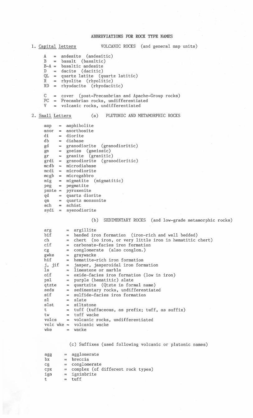
ABBREVIATIONS FOR ROCK TYPE NAMES
1. Capital letters VOLCANIC ROCKS (and general map units)
A = B = B-A = D = QL = R = RD
C = PC = V =
andesite (andesitic) basalt (basaltic) basaltic andesite dacite (dacitic) quartz latite (quartz latitic) rhyolite (rhyolitic) rhyodacite (rhyodacitic)
cover (post-Precambrian and Apache-Group rocks) Precambrian rocks, undifferentiated volcanic rocks, undifferentiated
2. Small Letters (a) PLUTONIC AND METAMORPHIC ROCKS
amp anor = di db = gd = gn gr = grdi = mcdb = mcdi = mcgb mig = peg = pxnte = qd = qm = sch = sydi =
arg bif ch cif cg gwke hif j, jif Is oif psI qtzte seds sif sl slst t tw volcs volc wke wke
agg bx cg cpx ign t
amphibolite anorthosite diorite diabase granodiorite (granodioritic) gneiss (gneissic) granite (granitic) granodiorite (granodioritic) micro diabase microdiorite microgabbro migmatite (migmatitic) pegmatite pyroxenite quartz diorite quartz monzonite schist syenodiorite
= = =
= = = = = =
= = =
= = = = =
= = = = =
(b) SEDIMENTARY ROCKS (and low-grade metamorphic rocks)
argillite banded iron formation (iron-rich and well bedded) chert (no iron, or very little iron in hematitic chert) carbonate-facies iron formation conglomerate (also conglom.) graywacke. hematite-rich iron formation jasper, jasperoidal iron formation limestone or marble oxide-facies iron formation (low in iron) purple (hematitic) slate quartzite (Qtzte in formal name) sedimentary rocks, undifferentiated sulfide-facies iron formation slate siltstone tuff (tuffaceous, as prefix; tuff, as suffix) tuff wacke volcanic rocks, undifferentiated volcanic wacke wacke
(c) Suffixes (used following volcanic or plutonic names)
agglomerate breccia conglomerate complex (of different rock types) ignimbrite tuff
![Geologic map of the Waterman Peak 7.5’ Quadrangle and ...repository.azgs.az.gov/sites/default/files/dlio/... · Mountains have been studied previously by McClymonds [1959a] and](https://img.pdfslide.net/doc/110x75/5f02f4467e708231d406d56e/geologic-map-of-the-waterman-peak-75a-quadrangle-and-mountains-have-been.jpg)