Embed Size (px)
Citation preview

Predicting the Suitability of Habitat in Southeast Idaho for Pygmy RabbitsAuthor(s): Kate I. Gabler, John W. Laundré, Laura T. HeadySource: The Journal of Wildlife Management, Vol. 64, No. 3 (Jul., 2000), pp. 759-764Published by: Allen PressStable URL: http://www.jstor.org/stable/3802746Accessed: 19/09/2009 17:43
Your use of the JSTOR archive indicates your acceptance of JSTOR's Terms and Conditions of Use, available athttp://www.jstor.org/page/info/about/policies/terms.jsp. JSTOR's Terms and Conditions of Use provides, in part, that unlessyou have obtained prior permission, you may not download an entire issue of a journal or multiple copies of articles, and youmay use content in the JSTOR archive only for your personal, non-commercial use.
Please contact the publisher regarding any further use of this work. Publisher contact information may be obtained athttp://www.jstor.org/action/showPublisher?publisherCode=acg.
Each copy of any part of a JSTOR transmission must contain the same copyright notice that appears on the screen or printedpage of such transmission.
JSTOR is a not-for-profit organization founded in 1995 to build trusted digital archives for scholarship. We work with thescholarly community to preserve their work and the materials they rely upon, and to build a common research platform thatpromotes the discovery and use of these resources. For more information about JSTOR, please contact [email protected].
Allen Press is collaborating with JSTOR to digitize, preserve and extend access to The Journal of WildlifeManagement.
http://www.jstor.org

PREDICTING THE SUITABILITY OF HABITAT IN SOUTHEAST IDAHO FOR PYGMY RABBITS KATE I. GABLER,1 2 Department of Biological Sciences, Idaho State University, Pocatello, ID 83209, USA JOHN W. LAUNDRE, Department of Biological Sciences, Idaho State University, Pocatello, ID 83209, USA LAURA T. HEADY,34 Department of Biological Sciences, Idaho State University, Pocatello, ID 83209, USA
Abstract: A geographic information system (GIS) model was developed for pygmy rabbit (Brachylagus ida- hoensis) habitat in southeastern Idaho. Areas of potential use by pygmy rabbits were determined from appro- priate vegetation and geological classes in a GIS analysis. Sites most likely to be occupied within potential vegetation and geologic habitat were determined by including appropriate slope and aspect measurements. Randomly selected areas within and outside of predicted areas were searched for pygmy rabbit sign. This resulted in a 57% probability of predicting areas occupied by pygmy rabbits and a 100% probability of pre- dicting areas not occupied. Our model may be useful in identifying areas unsuitable for pygmy rabbits and it is a useful first step in identifying appropriate habitat for the pygmy rabbit, potentially throughout their range.
JOURNAL OF WILDLIFE MANAGEMENT 64(3):759-764
Key words: Brachylagus idahoensis, distribution, GIS, habitat, Idaho, pygmy rabbit, sagebrush desert.
Pygmy rabbits are unique among leporids in that they rely on big sagebrush (Artemisia tri- dentata) for food. The pygmy rabbit has had a limited distribution within sagebrush areas of the Great Basin and adjacent intermountain ar- eas including the Snake River Plain in southern Idaho (Katzner 1994). An isolated population also occurs in eastcentral Washington (Lyman 1991, Washington Department of Fish and Wildlife 1995). However, pygmy rabbits histor- ically have had a greater distribution than they do today (Weiss and Verts 1984, Washington Department of Fish and Wildlife 1995).
The primary cause for the reduction in range is considered to be habitat loss. Across much of the historic range, sagebrush-steppe has been converted to cropland or has been used for live- stock grazing. Grazing continues to be the dom- inant use on sagebrush-steppe lands (West 1983). Overgrazing can potentially break down shrub cover, lead to loss of native grasses and forbs, and lead to invasions of annual species such as cheatgrass (Bromus tectorum; Washing- ton Department of Fish and Wildlife 1995). These changes could make an area unsuitable for pygmy rabbits. In addition, shrub cover is
1 Present address: 21127 Olinda Trail, P.O. Box 37, Scandia MN 55073, USA.
2 E-mail: [email protected] 3 Present address: Hudsonia, Bard College, P.O.
Box 5000, Annandale, NY 12504, USA. 4 E-mail: [email protected]
often manually or chemically reduced to im- prove forage production for livestock. This deg- radation and conversion of sagebrush lands has been extensive. For example, only about 60% of the original shrub-steppe remains in Wash- ington (Dobler 1992). Unfortunately, it is un- known how much suitable habitat may remain in the other parts of this species' range. For this reason, the pygmy rabbit is considered a species of special concern by the U.S. Fish and Wildlife Service.
We took the first step in developing a con- servation management plan for this species by assessing the current status of available habitat in a portion of its range. We developed a GIS predictive model for a 2,000-km2 sagebrush- steppe area in southeastern Idaho to calculate what percentage of suitable habitat remains and identify these areas for possible conservation ef- forts.
STUDY AREA The study was conducted on the Idaho Na-
tional Engineering and Environmental Labora- tory (INEEL), located on the upper Snake Riv- er Plain in southeastern Idaho. Mean annual precipitation for the INEEL was 22 cm, most of which falls during winter and early summer. Snow cover usually persisted for at least 4 to 5 months. Temperature can range from -44?C in winter to 38?C in summer.
The surface of the INEEL was gently rolling with some basalt flows and a few volcanic
759

760 PYGMY RABBITS AND GIS * Gabler et al.
buttes. The subsurface was made up of basalt from past lava flows. Most of the soil was de- rived from older silicic volcanic and paleozoic rocks from the surrounding mountains (Mc- Bride et al. 1978). In the southern portion of the INEEL, soils tended to be gravelly to rocky, while in the northern portion the soil was made up of lake and aeolian deposits composed main- ly of unconsolidated clay, silt, and sand (Kram- ber et al. 1992). Soil depth on the INEEL var- ied from a few centimeters on the more recent or exposed flows to several meters in low lying areas. Accumulation was also greater on lee- ward sides of lava ridges and on alluvial fans. The native vegetation at the INEEL consisted of a sagebrush dominated shrub overstory with an understory of perennial grasses and forbs (Anderson et al. 1996).
METHODS We used GIS modeling to develop a map de-
picting levels of potential habitat suitability for pygmy rabbits. We first performed a spatial analysis, based on known locations of pygmy rabbit burrow sites, on 4 thematic map layers: vegetation, surface geology, slope, and aspect. A predictive map incorporating overlays of these 4 layers was produced to display areas of poten- tially suitable habitat for pygmy rabbits. The ac- curacy of this predictive model was field tested by verifying the presence or absence of pygmy rabbits at randomly selected sites predicted to be used or not used by pygmy rabbits.
Locating and Recording Burrow Sites We surveyed the approximately 650 km of
widely distributed dirt roads (Fig. 1) on the INEEL during the winters of 1994-95 and 1995-96, and also during the spring of 1996 for existing pygmy rabbit burrows. When snow cov- er was present, the roads were driven to locate pygmy rabbit tracks. When tracks were found they were followed to burrow sites. When there was no snow cover, roads were driven and areas off the roads were systematically searched for burrows. Most roads on the INEEL consist of dirt 2-tracks that did not differ from the sur- rounding vegetation and were extensively dis- tributed in all possible habitat types. Thus, any road bias due to the types and placement of roads was considered minimal. In addition to surveying the roads, 3 earlier study areas (Wilde et al. 1976, Wilde 1978, Fisher 1979) were re- located and searched. When burrows were
0 10 20 Km
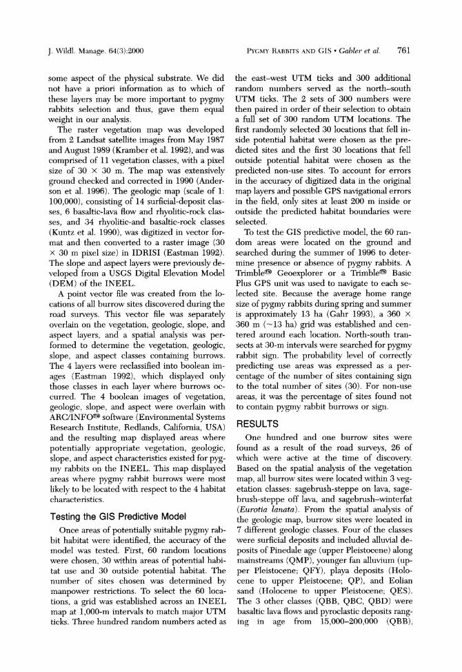
Fig. 1. Predicted suitable vegetation, geologic, slope, and as- pect classes. The 7 geologic classes are: surficial alluvial de- posits of Pinedale age (upper Pleistocene) along mainstreams (QMP), younger fan alluvium (upper Pleistocene) (QFY), playa deposits (Holocene to upper Pleistocene; QP), and Eolian sand (Holocene to upper Pleistocene; QES) and basaltic lava flows and pyroclastic deposits ranging in age from 15,000- 200,000 (QBB), 200,000-400,000 (QBC) and 400,000- 730,000 (QBD) years old. Areas where the 4 layers overlap represent predicted suitable pygmy rabbit habitat; all other ar- eas represent predicted non-use areas. The predicted sites and predicted non-use sites searched in this study are dis- played. The sites where pygmy rabbit sign was found are in- dicated.
found, the locations were recorded in UTM co- ordinates with either a Trimble? Geoexplorer or a Trimble? Basic Plus Global Positioning System (Trimble Navigation Limited, Sunny- vale, California, USA) and then differentially corrected.
Creating a GIS Predictive Model Development of the predictive model was
limited by the map overlays available: vegeta- tion, geology, slope, and aspect. Vegetation, slope, and aspect are known to be important in the suitability of a site for pygmy rabbits (Green 1978, Wilde 1978, Weiss and Verts 1984, Gahr 1993, Katzner 1994). Soil structure and texture are also considered important (Weiss and Verts 1984, soil conservation service) but no maps were available. As soil characteristics are often influenced by underlying geologic structure, we used an available geologic map to incorporate
J. Wildl. Manage. 64(3):2000
PYGMY RABBITS AND GIS * Gabler et al. 761
some aspect of the physical substrate. We did not have a priori information as to which of these layers may be more important to pygmy rabbits selection and thus, gave them equal weight in our analysis.
The raster vegetation map was developed from 2 Landsat satellite images from May 1987 and August 1989 (Kramber et al. 1992), and was comprised of 11 vegetation classes, with a pixel size of 30 X 30 m. The map was extensively ground checked and corrected in 1990 (Ander- son et al. 1996). The geologic map (scale of 1: 100,000), consisting of 14 surficial-deposit clas- ses, 6 basaltic-lava flow and rhyolitic-rock clas- ses, and 34 rhyolitic-and basaltic-rock classes (Kuntz et al. 1990), was digitized in vector for- mat and then converted to a raster image (30 X 30 m pixel size) in IDRISI (Eastman 1992). The slope and aspect layers were previously de- veloped from a USGS Digital Elevation Model (DEM) of the INEEL.
A point vector file was created from the lo- cations of all burrow sites discovered during the road surveys. This vector file was separately overlain on the vegetation, geologic, slope, and aspect layers, and a spatial analysis was per- formed to determine the vegetation, geologic, slope, and aspect classes containing burrows. The 4 layers were reclassified into boolean im- ages (Eastman 1992), which displayed only those classes in each layer where burrows oc- curred. The 4 boolean images of vegetation, geologic, slope, and aspect were overlain with ARC/INFO? software (Environmental Systems Research Institute, Redlands, California, USA) and the resulting map displayed areas where potentially appropriate vegetation, geologic, slope, and aspect characteristics existed for pyg- my rabbits on the INEEL. This map displayed areas where pygmy rabbit burrows were most likely to be located with respect to the 4 habitat characteristics.
Testing the GIS Predictive Model Once areas of potentially suitable pygmy rab-
bit habitat were identified, the accuracy of the model was tested. First, 60 random locations were chosen, 30 within areas of potential habi- tat use and 30 outside potential habitat. The number of sites chosen was determined by manpower restrictions. To select the 60 loca- tions, a grid was established across an INEEL map at 1,000-m intervals to match major UTM ticks. Three hundred random numbers acted as
the east-west UTM ticks and 300 additional random numbers served as the north-south UTM ticks. The 2 sets of 300 numbers were then paired in order of their selection to obtain a full set of 300 random UTM locations. The first randomly selected 30 locations that fell in- side potential habitat were chosen as the pre- dicted sites and the first 30 locations that fell outside potential habitat were chosen as the predicted non-use sites. To account for errors in the accuracy of digitized data in the original map layers and possible GPS navigational errors in the field, only sites at least 200 m inside or outside the predicted habitat boundaries were selected.
To test the GIS predictive model, the 60 ran- dom areas were located on the ground and searched during the summer of 1996 to deter- mine presence or absence of pygmy rabbits. A Trimble? Geoexplorer or a Trimble? Basic Plus GPS unit was used to navigate to each se- lected site. Because the average home range size of pygmy rabbits during spring and summer is approximately 13 ha (Gahr 1993), a 360 x 360 m (-13 ha) grid was established and cen- tered around each location. North-south tran- sects at 30-m intervals were searched for pygmy rabbit sign. The probability level of correctly predicting use areas was expressed as a per- centage of the number of sites containing sign to the total number of sites (30). For non-use areas, it was the percentage of sites found not to contain pygmy rabbit burrows or sign.
RESULTS
One hundred and one burrow sites were found as a result of the road surveys, 26 of which were active at the time of discovery. Based on the spatial analysis of the vegetation map, all burrow sites were located within 3 veg- etation classes: sagebrush-steppe on lava, sage- brush-steppe off lava, and sagebrush-winterfat (Eurotia lanata). From the spatial analysis of the geologic map, burrow sites were located in 7 different geologic classes. Four of the classes were surficial deposits and included alluvial de- posits of Pinedale age (upper Pleistocene) along mainstreams (QMP), younger fan alluvium (up- per Pleistocene; QFY), playa deposits (Holo- cene to upper Pleistocene; QP), and Eolian sand (Holocene to upper Pleistocene; QES). The 3 other classes (QBB, QBC, QBD) were basaltic lava flows and pyroclastic deposits rang- ing in age from 15,000-200,000 (QBB),
J. Wildl. Manage. 64(3):2000

762 PYGMY RABBITS AND GIS * Gabler et al.
200,000-400,000 (QBC), and 400,000-730,000 (QBD) years.
Based on the spatial analysis of the aspect layer, 32% of burrow locations had no aspect. Sixty-eight percent of burrow locations had as- pects ranging from 300 to 360? and 0 to 120? with a mean of 38.7?. From the spatial analysis of the slope layer, burrow locations had slopes ranging from 0.0 to 25%, with a mean of 8.6%. Because of computer memory constraints, it was not possible to create modified boolean im- ages using the full range of slopes and aspects. Therefore, aspects between 0 to 120? and be- tween 300 to 360?, which include 84.5% of all the burrow locations, were selected to make up the modified aspect image. Slopes between 0 and 15%, which include 83.5% of all burrow locations, were selected to make up the modi- fied slope image. In the final image, the slope, aspect, vegetation, and geologic layers over- lapped on only 23.4% of the total area of the INEEL (Fig. 1). This image represents areas predicted most suitable for pygmy rabbits.
No pygmy rabbit sign was found at any of the 30 predicted non-use sites. Thus, based on this analysis, there was a 100% probability of pre- dicting non-use areas. Of the 30 predicted pyg- my rabbit sites, sign was found at 17 locations (57% probability of predicting use areas). Twelve of the 17 sites contained abandoned burrows with either old or fresh scat of pygmy rabbit. One of the 17 sites contained fresh scat but no burrows, and 3 other sites contained old scat with no burrows.
DISCUSSION Others have investigated vegetation (Grinnell
et al. 1930, Orr 1940, Severaid 1950, Green and Flinders 1980, Weiss and Verts 1984, Katzner 1994), slope, and aspect (Wilde 1978) charac- teristics at burrow systems of pygmy rabbits. Our study combines these 3 categories (vege- tation, slope, and aspect) as well as the fourth of surficial geology, in a large scale GIS analysis. The result indicates that suitable habitat for pygmy rabbits on the INEEL consists of sage- brush-steppe or sagebrush-winterfat commu- nities situated on lava flows older than 15,000 years in age and on alluvial deposits of upper Pleistocene, playa deposits, and eolian sand (>50%) deposits. Within these areas, pygmy rabbits construct burrows in locations with 0 to 49.7% slope and a mean orientation of 38.7?.
Our results for vegetation agree in general
with the findings of others (Severaid 1950, Green and Flinders 1980, Weiss and Verts 1984, Soil Conservation Service 1991, Gahr 1993, Katzner 1994). Wilde (1978) also reported that pygmy rabbit burrows on the INEEL were in areas with a slope >5% and a northeast aspect. However, in contrast to ours and Wilde's find- ings, 53% of pygmy rabbit burrow sites in Washington were on south-southeast or south- west aspects (Soil Conservation Service 1991). Pygmy rabbits can only dig burrows where the soil is sufficiently deep (Weiss and Verts 1984, Wilde 1978). Deeper soils on the INEEL are more common on northeast slopes as a result of the prevailing southwest winds. Perhaps in the Washington study site, sufficiently deep soils may have been more readily available and did not restrict site selection by pygmy rabbits. Thus, except for the differences in burrow as- pect, our results match those of others. This concordance among the results of small scale studies indicates our larger scale model could be used to assess the suitability of habitat in most areas within pygmy rabbit range.
Based on our GIS analysis, the probability of an area actually containing pygmy rabbits or sign was 57%. Stoms et al. (1992) proposed var- ious factors regarding habitat maps that could be sources of uncertainty, and thus could affect the sensitivity of a GIS analysis. Some of these uncertainties likely contributed to our relatively low success in predicting suitable habitat. For example, although the predicted sites that had no pygmy rabbit sign were in sagebrush-steppe vegetation, based on the vegetation map of the INEEL (Kramber et al. 1992, Anderson et al. 1996), the map was not detailed enough to dis- tinguish between sparse sagebrush cover and the greater cover required by pygmy rabbits (Gabler 1997, Green and Flinders 1980, Weiss and Verts 1984). Thus, 10 of the 13 predicted sites that contained no sign, consisted of dead and-or very short, sparse sagebrush. In addi- tion, the vegetation map used was based on sat- ellite images taken in 1987 and 1989. Temporal variability in climate in 7-9 years could cause significant changes within a local patch of veg- etation (Anderson et al. 1996). Range fires can also alter the habitat dramatically; 13% of the habitat predicted as suitable was burned by fires in 1994, 1995, and 1996 (unpublished data). Thus, the use of updated images and possibly additional map layers (e.g., soil texture-depth)
J. Wildl. Manage. 64(3):2000
PYGMY RABBITS AND GIS Gabler et al. 763
could increase the sensitivity of our analysis in predicting suitable habitat for pygmy rabbits.
The probability of predicting non-use areas was 100%. Much of the area classified as non- use bordered the downstream portions of 2 riv- ers and was subject to flooding (Kuntz et al. 1990, Olson et al. 1995). Some of the non-use areas was also devoid of big sagebrush, and oth- ers contained lava flows <15,000 years old with only thin and discontinuous sand deposits (Kuntz et al. 1990). None of these factors are conducive to the construction and maintenance of burrows of pygmy rabbits (Wilde 1978, Green and Flinders 1980, White et al. 1982, Gabler 1997, Katzner and Parker 1997, Heady 1998).
Relative to conservation of pygmy rabbits, the GIS analysis indicates that large portions of what may seem like rabbit habitat may indeed not be suitable for their use. Although all of the 2,300 km2 of the INEEL is considered within pygmy rabbit range, when we considered the specific vegetation, geologic, slope, and aspect characteristics, only 23% of the site (530 km2) was considered possible burrowing habitat, es- sential for this species. Of that area, based on our probability level of accuracy in predicting areas of use, only 60% (320 km2) had a good likelihood of actually having been occupied by pygmy rabbits. If our model is accurate and pygmy rabbits are the habitat specialists that re- search indicates (Green and Flinders 1980, Ga- bler 1997, Katzner and Parker 1997, Heady 1998), then large portions of native vegetation within what is currently depicted as pygmy rab- bit range is likely not suitable habitat. If we also consider that much of the area within this range is being converted to farmland or being degrad- ed by overgrazing (Dober 1992, Washington Department of Fish and Wildlife 1995), it may be imperative to the conservation of this species to identify those areas of the Great Basin that
represent usable pygmy rabbit habitat.
MANAGEMENT IMPLICATIONS Pygmy rabbits likely select areas for use on a
smaller scale than can be completely provided for by this GIS model. This model, however, can be a very useful first step when trying to assess the suitability of an area for pygmy rab- bits. Used alone, this model was very successful at identifying areas that are definitely unsuitable for pygmy rabbits. The ability to identify un- suitable areas in itself is of obvious importance
in the management of a species. Our model can effectively eliminate those areas unsuitable for pygmy rabbits, enabling managers to concen- trate their efforts and resources on those areas more likely to have pygmy rabbits. Once within predicted suitable habitat, as identified from the GIS map, further analysis of the habitat on a smaller scale (Gabler 1997) may be necessary to determine if an area is indeed suitable hab- itat for pygmy rabbits. What remains is a testing of this model in other parts of the range of pyg- my rabbits to determine its applicability and-or adjustments that might need to be made (e.g., slope) in the criteria for the map layers.
ACKNOWLEDGMENTS The Environmental Science and Research
Foundation (ESRF), under contract with the U.S. Department of Energy and the U.S. De- partment of Interior, Bureau of Land Manage- ment provided funding for this project. We thank 0. D. Markham, R. Morris, and R. War- ren from the ESRF for their help. Many thanks are due to all the ESRF technicians for their assistance with the field work. We are indebted to R.D. Lee for his work on the production of maps. Thanks are also due to S. Cooper, M. Gabler, and C. R. Peterson for their assistance with various aspects of this project. We thank T. D. Reynolds, L. Hernmandez, and R. Warren for reviewing this manuscript.
LITERATURE CITED
ANDERSON, J. E., K. T. RUPPEL, J. M. GLENNON, K. E. HOLTE, AND R. C. ROPE. 1996. Plant com- munities, ethnoecology, and flora of the Idaho National Engineering Laboratory. Environmental Science and Research Foundation Report Series No. 005, Idaho Falls, Idaho, USA.
DOBLER, F. C. 1992. The shrub-steppe ecosystem of Washington: a brief summary of knowledge and nongame wildlife conservation needs. Washing- ton Department of Wildlife, Olympia, Washing- ton, USA.
EASTMAN, J. R. 1992. Idrisi technical reference. Ver- sion 4.0. Clark University, Worcester, Massachu- setts, USA.
FISHER, J. S. 1979. Reproduction in the pygmy rabbit in southeastern Idaho. Thesis, Idaho State Uni- versity, Pocatello, Idaho, USA.
GABLER, K. I. 1997. Distribution and habitat require- ments of the pygmy rabbit (Brachylagus idahoen- sis) on the Idaho National Engineering and En- vironmental Laboratory. Thesis, Idaho State Uni- versity, Pocatello, Idaho, USA.
GAHR, M. L. 1993. Natural history, burrow habitat and use, and home range of the pygmy rabbit (Brachylagus idahoensis) of Sagebrush Flat,
J. Wildl. Manage. 64(3):2000
764 PYGMY RABBITS AND GIS * Gabler et al.
Washington. Thesis, University of Washington, Seattle, Washington, USA.
GREEN, J. S. 1978. Pygmy rabbit and coyote investi- gations in southeastern Idaho. Dissertation, Brigham Young University, Provo, Utah, USA.
, AND J. T. FLINDERS. 1980. Habitat and die- tary relationships of the pygmy rabbit. Journal of Range Management 33:136-142.
GRINNELL, J., J. DIXON, AND J. M. LINSDALE. 1930. Vertebrate natural history of a section of northern California through the Lassen Peak Region. Uni- versity of California Publications in Zoology 35: 1-594.
HEADY, L.T. 1998. Home range, habitat, and activity patterns of pygmy rabbits (Brachylagus idahoen- sis) in southeastern Idaho. Thesis, Idaho State University, Pocatello, Idaho, USA.
KATZNER, T. E. 1994. Winter ecology of the pygmy rabbit (Brachylagus idahoensis) in Wyoming. Thesis, University of Wyoming, Laramie, Wyo- ming, USA.
, AND K. L. PARKER. 1997. Vegetative char- acteristics and size of home ranges used by pyg- my rabbits (Brachylagus idahoensis) during win- ter. Journal of Mammalogy 78:1063-1072.
KRAMBER, W. J., R. C. ROPE, J. ANDERSON, J. GLEN- NON, AND A. MORSE. 1992. Producing a vegeta- tion map of the Idaho National Engineering Lab using Landsat Thematic Mapper data. Proceed- ings of the American Society for Photogrammetry and Remote Sensing/American congress on Sur- veying and Mapping. 1:217-226.
KUNTZ, M. A., B. SKIPP, M. A. LANPHERE, W. E. ScoTT, K. L. PIERCE, G. B. DALRYMPLE, L. A. MORGAN, D. E. CHAMPION, G. F. EMBREE, R. P. SMITH, W R. HACKETT, AND D. W. RODGERS. 1990. Revised geologic map of the Idaho National Engineering Laboratory and adjoining areas. U.S. Geological Survey Open File Report 90-333, Ida- ho Falls, Idaho, USA.
LYMAN, R. L. 1991. Late Quaternary biogeography of the pygmy rabbit (Brachylagus idahoensis) in eastern Washington. Journal of Mammalogy 72: 110-117.
McBRIDE, R., N. R. FRENCH, A. H. DAHL, AND J. E. DETMER. 1978. Vegetation types and surface soils of the Idaho National Engineering Laboratory Site. U.S. Department of Energy, Radiological
and Environmental Sciences Laboratory, Idaho Falls, Idhao, USA.
OLSON, G. L., D. J. JEPPESEN, AND R. D. LEE. 1995. The status of soil mapping for the Idaho National Engineering Laboratory. Lockheed Idaho Tech- nologies, Idaho Falls, Idaho, USA.
ORR, R. T. 1940. The rabbits of California. Occasional Papers of the California Academy of Sciences 19: 1-227.
SEVERAID, J. H. 1950. The pygmy rabbit (Sylvilagus idahoensis) in Mono County, California. Journal of Mammalogy 31:1-4.
SOIL CONSERVATION SERVICE. 1991. Soil survey of Ephrata County area, Washington. Soil Conser- vation Service, Ephrata, Washington, USA.
STOMS, D. M., F. W. DAVIS, AND C. B. COGAN. 1992. Sensitivity of wildlife habitat models to uncertain- ties in GIS data. Photogrammetric Engineering and Remote Sensing 58:843-850.
WASHINGTON DEPARTMENT OF FISH AND WILDLIFE. 1995. Washington state recovery plan for the pyg- my rabbit. Wildlife Management Program, Wash- ington Department of Fish and Wildlife, Olym- pia, Washington, USA.
WEISS, N. T. AND B. J. VERTS. 1984. Habitat and dis- tribution of pygmy rabbits (Sylvilagus idahoensis) in Oregon. Great Basin Naturalist 44:563-571.
WEST, N. E. 1983. Western intermountain sagebrush steppe. Pages 351-374 in N. E. West, editor. Temperate deserts and semi-deserts. Elsevier Sci- entific, New York, New York, USA.
WHITE, S. M, J. T. FLINDERS, AND B. L. WELCH. 1982. Preference of pygmy rabbit (Brachylagus idahoensis) for various populations of big sage- brush (Artemisia tridentata). Journal of Range Management 35:724-726.
WILDE, D. B. 1978. A population analysis of the pyg- my rabbit (Sylvilagus idahoensis) on the INEL site. Dissertation, Idaho State University, Poca- tello, Idaho, USA.
, J. S. FISHER, AND B. L. KELLER. 1976. A demographic analysis of the pygmy rabbit Sylvi- lagus idahoensis. Pages. 88-105 in 0. D. Mark- ham, editor 1975 Progress report, Idaho National Engineering Laboratory Site Radeoecology-ecol- ogy programs, National Technical Information Service, Springfield, Virginia, USA.
Received 14 April 1999 Accepted 18 January 2000 Associate Editor Sullivan
J. Wildl. Manage. 64(3):2000