Embed Size (px)
Citation preview
AMEC Earth & Environmental a Division of AMEC Americas Limited 2227 Douglas Road, Burnaby, BC Canada V5C 5A9 Tel +1 (604) 294-3811 Fax +1 (604) 294-4664 www.amec.com
Preliminary Geotechnical HDD Feasibility Assessment
Smoky River (Crossing #3174)
Proposed Enbridge Northern Gateway Pipelines
Rev R KP421.6
Submitted to:
Northern Gateway Pipelines Inc.
Calgary, Alberta
Submitted by:
AMEC Earth & Environmental, a division of AMEC Americas Limited
Burnaby, BC
July 14, 2010
AMEC File: EG0926008.3000
Document Control No. 1154-WC-20100714

Northern Gateway Pipelines Inc. Preliminary Geotechnical HDD Feasibility Assessment Smoky River (Crossing #3174) July 14, 2010
AMEC File: EG0926008.3000 Page ii
TABLE OF CONTENTS
Page
1.0 PROJECT DESCRIPTION ............................................................................................. 1-1
2.0 SCOPE ........................................................................................................................... 2-1
3.0 GEOTECHNICAL AND HYDROTECHNICAL SITE CONDITIONS ................................. 3-1 3.1 Sources of Information ........................................................................................... 3-2 3.2 Topography ............................................................................................................ 3-1 3.3 Geology ................................................................................................................. 3-2 3.4 Slope Stability ........................................................................................................ 3-3 3.5 Stream Characteristics ........................................................................................... 3-4
4.0 PRELIMINARY GEOTECHNICAL ASSESSMENT ......................................................... 4-1 4.1 Horizontal Directional Drill (HDD) Crossing ............................................................ 4-1 4.2 Contingency Crossing Method ............................................................................... 4-2
5.0 FUTURE GEOTECHNICAL WORK TO SUPPORT DETAILED DESIGN ....................... 5-1
6.0 CLOSURE ...................................................................................................................... 6-1
REFERENCES ........................................................................................................................ 6-2
LIST OF FIGURES
Figure 1: Mean Monthly Flows of Smoky River at Crossing .................................................... 3-5
LIST OF PHOTOS Photos 1 to 5 Photos 6 to 11
LIST OF DRAWINGS
Drawing 08-3000-0421-1 Smoky River Site Plan Drawing 08-3000-0421-2 Smoky River Terrain Typing Drawing 08-3000-0421-3 Smoky River Detailed Site Plan

IMPORTANT NOTICE
This report was prepared exclusively for Northern Gateway Pipelines Inc. by AMEC Earth & Environmental Limited, a wholly owned subsidiary of AMEC. The quality of information, conclusions and estimates contained herein is consistent with the level of effort involved in AMEC services and based on: i) information available at the time of preparation, ii) data supplied by outside sources, and iii) the assumptions, conditions and qualifications set forth in this report. This report is intended to be used by Northern Gateway Pipelines Inc. only, subject to the terms and conditions of its contract with AMEC. Any other use of, or reliance on, this report by any third party is at that party’s sole risk.


Northern Gateway Pipelines Inc. Preliminary Geotechnical HDD Feasibility Assessment Smoky River (Crossing #3174) July 14, 2010
AMEC File: EG0926008.3000 Page 1-1
1.0 PROJECT DESCRIPTION
Northern Gateway Pipelines Inc. (Northern Gateway), a subsidiary of Enbridge Pipelines Inc., initiated the regulatory phase of the Enbridge Northern Gateway Project (the Project) to obtain regulatory approvals to construct and operate the Project. The Project is being developed to provide pipelines and associated facilities for the transportation of approximately 83,400 m3/d (525,000 bbl/d) of oil from Bruderheim, Alberta to Kitimat, British Columbia and the transportation of approximately 30,700 m3/d (193,000 bbl/d) of condensate from Kitimat to Bruderheim. The Project includes the following major components:
• an oil pipeline, 914 mm OD (NPS 36), approximately 1172 km long extending from the outlet of the Bruderheim station to the Kitimat Terminal
• a condensate pipeline, 508 mm OD (NPS 20), approximately 1172 km long, located in the same right-of-way as the oil pipeline, extending from the Kitimat Terminal to the Bruderheim Station
• the Bruderheim Station, consisting of the oil initiating pump station and the condensate receiving facilities
• eight intermediate pump stations located at intervals along the pipelines • two tunnels, approximately 6.5 km and 6.6 km long, to route the oil and condensate
pipelines between the Clore River and Hoult Creek valleys • the Kitimat Terminal which will comprise the following:
o a tank terminal including oil tanks, condensate tanks and associated infrastructure
o a marine terminal including two tanker berths and one utility berth o an initiating condensate pump station
oil receiving facilities
Northern Gateway Pipelines Inc. Preliminary Geotechnical HDD Feasibility Assessment Smoky River (Crossing #3174) July 14, 2010
AMEC File: EG0926008.3000 Page 2-1
2.0 SCOPE
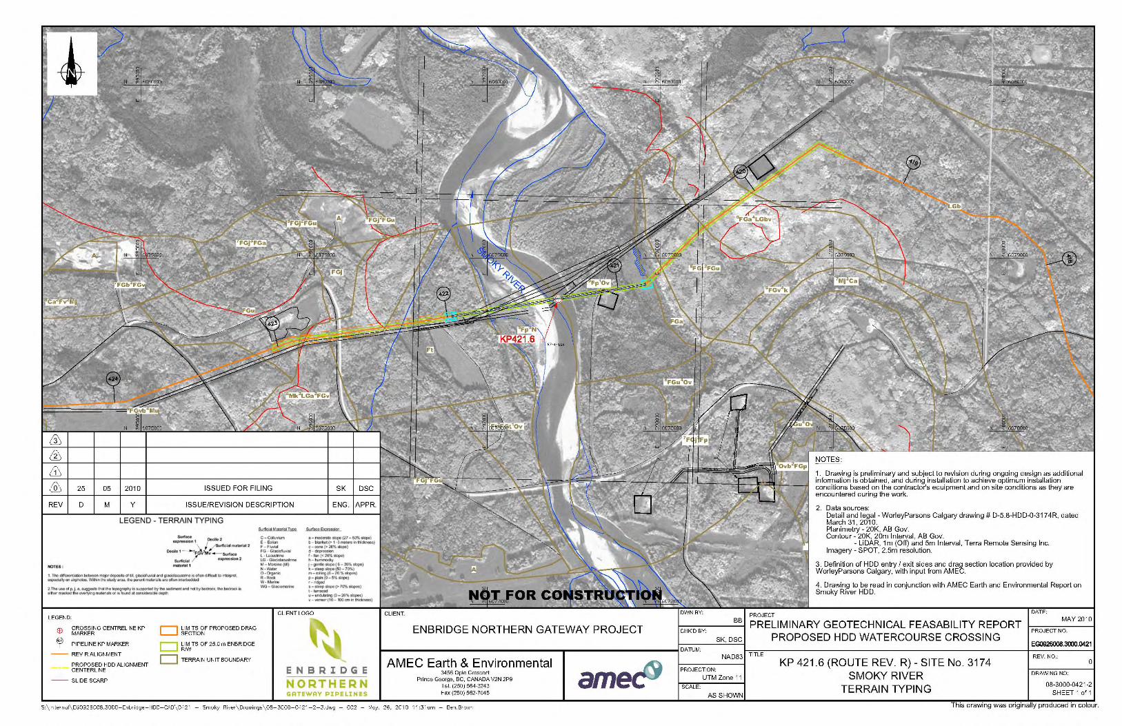
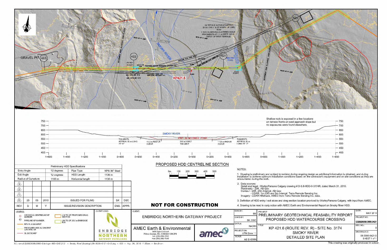
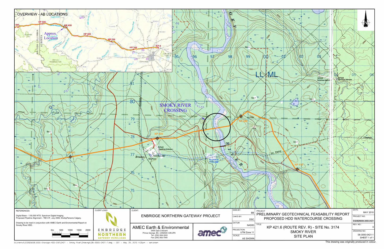
This report provides a preliminary geotechnical and hydrotechnical feasibility assessment of a proposed horizontal directional drill (HDD) crossing and a contingency crossing method for the Enbridge Northern Gateway Project at the Smoky River (Crossing #3174), KP 421.6 of the Rev R Alignment, as shown on Drawing 08-3000-0421-1.
Northern Gateway Pipelines Inc. Preliminary Geotechnical HDD Feasibility Assessment Smoky River (Crossing #3174) July 14, 2010
AMEC File: EG0926008.3000 Page 3-1
3.0 GEOTECHNICAL AND HYDROTECHNICAL SITE CONDITIONS
3.1 Sources of Information
The following sources of information on site conditions were available at the time of report preparation:
1. Aerial photography (75-1 I.R. AS1408 LINE 37 No. 31 to 33, LINE 38 No. 132 to 133 86-140 AS3368 No. 25 to 28, No. 66 to 69, No. 106 to 109, 89-161 AS3945 No. 158 to 161, 05-004 AS5352B No. 96 to 100).
2. Project terrain mapping (Drawing 08-3000-0421-2).
3. Topographic (bare earth hill shade) models generated by from LiDAR survey (Drawing 08-3000-0421-3).
4. Geotechnical reconnaissances have been carried out at several locations along the valley including the presently considered crossing using airborne and ground methods in 2006, 2007 and 2008.
5. Surficial geology (Andriashek 1983), bedrock geology mapping (Hamilton, Price, Langenberg 1999; McMechan and Dawson 1995), and bedrock topography (Pawlowicz and Fenton 1995).
6. Two borehole investigations were undertaken south of the proposed Rev R crossing near the previously considered Rev A and Rev N alignments. These boreholes were used for general background; the logs have not been included due to the distance from the presently considered alignment.
7. Flow information from a gauging station located upstream of the Rev R alignment.
3.2 Topography
The Smoky River originates in the Rocky Mountains near Mount Robson, Alberta, about 200 km to the south of the crossing. The river flows north to northeast across the Southern Alberta Uplands and Alberta Plateau, joins with the Wapiti River near Grande Prairie, approximately 35 km north-northeast of the proposed crossing, and eventually enters the Peace River some 150 km to the north. Near the proposed crossing, the Smoky River flows in a valley up to 150 m deep and 2 to 4 km wide. The uplands on the west side of the valley are at elevations of 700 to 800 m and are rolling to ridged. Similar conditions are present on the uplands east of the river with slightly lower elevations. Streams with typically V-shaped valleys are incised into the uplands on both sides of the river valley. Valley slopes are gentle to steep depending on location (slope segments ranging from 4° to 45°). Flat terraces are located within the valley on either side of the river at some locations including the east side of the proposed crossing. The conditions at the crossing are summarized below in more detail.

Northern Gateway Pipelines Inc. Preliminary Geotechnical HDD Feasibility Assessment Smoky River (Crossing #3174) July 14, 2010
AMEC File: EG0926008.3000 Page 3-2
The proposed crossing approximately parallels existing rights-of-way that have been in place for many years. Based on signs found in the field, there are three parallel pipelines. The pipelines are reportedly owned by Canadian Natural Resources Ltd. (CNRL) and carry sour gas, natural gas and/or sour liquids. The Alliance Pipeline and other pipelines owned by Nova Corp. and CNRL cross the river approximately 1.5 km south of the Rev R crossing. The Gold Creek Gas Plant is located on the uplands 3.6 km west of the crossing, south of the Rev R alignment. There are numerous well sites, dehydration facilities and small compressor stations along the valley bottom and on the uplands both east and west of the river crossing. On the east approach slope, Rev R deviates slightly from the existing rights-of-way and crosses the terrace at the toe of the slope south of a large beaver pond. Consideration will be given during detailed design to paralleling the existing rights-of-way more closely to cross the beaver pond near the north end where it was approximately 20 m wide. The east approach slope is approximately 120 m high at an overall angle of 8.5°. There are two prominent terraces on the slope with terrace fronts at typical angles of 30° with flatter slopes in some areas where local erosion has occurred. There is also a lower elevation terrace on the lower part of the slope. At the toe of the slope, the beaver pond discussed above extended approximately 200 m south of the CNRL RoW and a wetland existed along the toe of the slope to the north. The river valley bottom is approximately 500 m wide at the crossing, including the actual channel and adjacent areas of bars. There are broad terraces approximately 3 to 15 m above the river on both sides of the channel. A low elevation terrace on the east side of the valley is almost 500 m wide and a similar low elevation terrace on the west side is 550 m wide. The crossing is located upstream of a sharp 90° bend in the river. The west approach slope is approximately 65 m high. The route crosses the Canfor Smoky Cutacross Road on the lower part of the slope and parallels the north side of the CNRL RoW across the extreme north edge of an existing deep-seated slide. During detailed design, consideration will be given to deviating to the north along a ridge (also followed by the road). Deviations at the toe of the slope around the edge of another side area will also be considered. Both deviations would be within the route corridor centered on Rev R. 3.3 Geology
Along the Rev R alignment, glaciolacustrine silts and clays have been mapped on the eastern uplands with undifferentiated glaciofluvial and aeolian deposits mid-slope and colluvium at the toe of the slope according to Andriashek (1983). In the field, glaciofluvial sands and gravels were identified on terraces on both sides of the river; a 300 to 500 m wide by 1800 m long terrace occurs near the crest of the western slope while some areas of gravel mining and two prominent terraces occur on the eastern slope. Bedrock was observed in outcrops and cliff bands north of and near the Rev R alignment on the eastern side of the Smoky River valley. Cuts into the backslope on the CNRL RoW near the crest of the eastern slope revealed silty fine-grained sands. Glaciolacustrine deposits may be present on the western slopes south of the Rev R alignment and may contribute to the large deep-seated slope instability (discussed in detail in Section 3.4). Bedrock was not identified on the west slope.
Northern Gateway Pipelines Inc. Preliminary Geotechnical HDD Feasibility Assessment Smoky River (Crossing #3174) July 14, 2010
AMEC File: EG0926008.3000 Page 3-3
The area is underlain by the Upper Wapiti Formation, equivalent to the Horseshoe Canyon Formation (Hamilton et al. 1999). The Wapiti Formation consists of grey feldspathic sandstone, grey bentonitic mudstone and carbonaceous shale, and scattered coal and bentonite beds. Bedrock dipping shallowly to the northeast is exposed in outcrop mid-slope on the eastern approach slope. Pawlowicz and Fenton (1995a) do not indicate any major pre-glacial channels on this section of the Smoky River system. They do show a channel of the Brazeau pre-glacial valley system north of the site and it is possible that a tributary to the Brazeau system passes through the study area. Aerial reconnaissance showed meander bends undercutting bedrock in some locations and valley fill in others, indicating that a preglacial channel could be present on either side of the present river valley at various locations. Boreholes on a previously considered alignment south of the present crossing indicated that the bedrock valley bottom (possibly the preglacial valley bottom) was 5 to 10 m below the present river channel. Sand- to boulder-sized material may occur in the deepest part of the preglacial valley. These sediments are usually overlain by interbedded glaciofluvial, glaciolacustrine, and glacial tills placed during multiple phases of ice advance and retreat. Preservation of these old bouldery sediments appears to have been discontinuous along the Smoky River valley depending upon the degree of incision by the river. Glaciofluvial deposits including terraces occur along both sides of the valley in various locations and glaciofluvial sediments likely underlie the valley floor. Post-glacial fluvial sands and gravel occur along the valley floor on both sides of the present river channel.
3.4 Slope Stability
On a regional basis, slides are widespread along the Smoky River Valley slopes and include numerous shallow to deep-seated failures. Regionally, individual slides typically form slide complexes that in some areas may include more or less continuous deep-seated slides along the valley slopes for long distances. The Rev R alignment was chosen due to its more favourable slope conditions compared to other routes examined along the Smoky Valley. Slope and other conditions adjacent to the Rev R alignment are shown on Photos 1 to 11. The apparent extents of the slides near the proposed route are shown on Drawing 08-3000-0421-3. On the east approach slope, moderately deep to deep-seated landslides have been identified north and south of the Rev R alignment. One slide approximately 600 m north of the proposed route appeared to be relatively active where it is undercut by the river. The slides to the south appeared to be less active, and were not being undercut by the river. Shallow erosional gullies and some areas of groundwater piping erosion occur north of the existing CNRL RoW. Based on ground reconnaissance, the proposed route on the east approach slope does not cross any identified deep-seated failures, although there may be some shallow sloughing of steep terrace fronts and there may be old shallow to moderately deep slides in the lower portions of the slope. No evidence of any significant recent movement or movement features was identified on the ground along the proposed route. The apparently better local stability along the route may be due to shallow bedrock on parts of the slope.
Northern Gateway Pipelines Inc. Preliminary Geotechnical HDD Feasibility Assessment Smoky River (Crossing #3174) July 14, 2010
AMEC File: EG0926008.3000 Page 3-4
On the western side of the Smoky River, a large deep-seated landslide was identified south of the proposed route and was an important consideration for routing in this area. Fieldwork suggests that this landslide may be moving very slowly at the northern end and more rapidly at the south end. Swept trees at angles up to 10° were found at the south end of the slide, with few tree distortions found at the north end. Grabens were observed near the crest along the length of the slide. Other features indicative of deep-seated sliding, including hummocky ground and characteristic contours, were visible on the LiDAR hillshade and slope shade models. One very small ground crack was found directly south of the CNRL RoW with several larger cracks along the headscarp and graben farther south near the end of the slide. Irregular contours and slide features were identifiable on LiDAR hillshade models. 3.5 Stream Characteristics
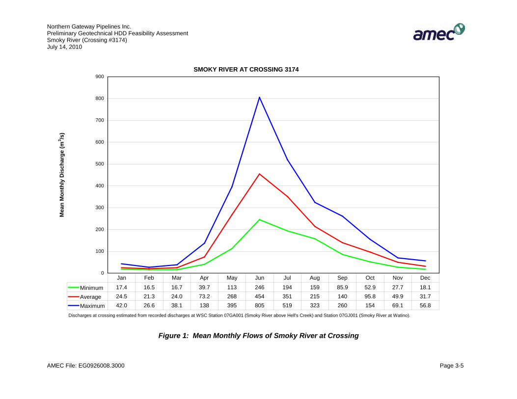
The Smoky River channel was approximately 150 m wide at the Rev R crossing corridor during the June 2008 site visit. Average flows, estimated based on a gauging station located upstream from the Rev R crossing, vary between a low of 21.3 m3/s in February and a high of 454 m3/s in June. Figure 1, below, shows the estimated mean monthly flows at the crossing. The Smoky River meanders throughout the overall valley and is actively eroding the toes of slopes in some areas, particularly at bends in the river. Upstream and downstream of the Rev R crossing, the channel shows numerous signs of bar development and island formation. Approximately 1 km upstream of the crossing, the road bridge has confined the channel to approximately 60% of the pre-construction width. This will have resulted in deeper and faster flows through this section. About 300 m downstream of the bridge, the west bank of the river has shifted up to 100 m west between 1975 and 2005 (average 5 m lateral movement per year). Over the same period, erosion along the east bank and deposition along the west bank at the crossing shifted the channel at least 90 m east. This has increased the curvature of the bend at the crossing and has correspondingly increased the scour potential at the site. Downstream of the crossing, oxbows and abandoned channels are readily identifiable from the air. The active floodplain is approximately 500 m wide, but the flows are constrained by the upstream bridge fills. Riprap and ice protection on the bridge piers extend almost to the bottom chord of the bridge, indicating that high water is significantly above the normal river levels (the maximum elevation of the riprap may also consider high water levels due to ice jamming). Loss of the road fills would result in active erosion over a width of as much as 1000 m. Note that the overall width of the floodplain and area of low terraces subject to lateral erosion is 1600 m at the Rev R alignment from toe of slope to toe of slope. Within this wide area, it may be difficult to accurately predict the directions and amounts of lateral erosion. Thus, a trenched crossing would likely be very long, probably longer than 1000 m. The bridge should not be counted on for long-term protection. River training works to protect the pipeline from lateral erosion would need to be substantial, if considered. Preliminary estimates suggest that the local scour may be 3 m below existing bed levels but could be greater depending on channel configuration.
Northern Gateway Pipelines Inc. Preliminary Geotechnical HDD Feasibility Assessment Smoky River (Crossing #3174) July 14, 2010
AMEC File: EG0926008.3000 Page 3-5
SMOKY RIVER AT CROSSING 3174
0
100
200
300
400
500
600
700
800
900
Mea
n M
onth
ly D
isch
arge
(m3 /s
)
Minimum 17.4 16.5 16.7 39.7 113 246 194 159 85.9 52.9 27.7 18.1
Average 24.5 21.3 24.0 73.2 268 454 351 215 140 95.8 49.9 31.7
Maximum 42.0 26.6 38.1 138 395 805 519 323 260 154 69.1 56.8
Jan Feb Mar Apr May Jun Jul Aug Sep Oct Nov Dec
Discharges at crossing estimated from recorded discharges at WSC Station 07GA001 (Smoky River above Hell's Creek) and Station 07GJ001 (Smoky River at Watino).
Figure 1: Mean Monthly Flows of Smoky River at Crossing
Northern Gateway Pipelines Inc. Preliminary Geotechnical HDD Feasibility Assessment Smoky River (Crossing #3174) July 14, 2010
AMEC File: EG0926008.3000 Page 4-1
4.0 PRELIMINARY GEOTECHNICAL ASSESSMENT
The geotechnical and hydrotechnical assessments of an HDD crossing and a potential contingency crossing method are summarized below. 4.1 Horizontal Directional Drill (HDD) Crossing
The preliminary HDD crossing is shown on Drawing 08-3000-0421-3. An HDD crossing at the proposed location is considered appropriate for the purposes of project planning based on the preliminary information outlined above and the preliminary no-drill zone shown on Drawing 08-3000-0421-3. It is understood that nearby crossings have been installed using directional drilling methods. The preliminary no-drill zone was established using the following criteria:
1. Maintaining the static mud pressure in the directional drill hole to a level less than or equal to the vertical overburden total stress under the valley bottom. This methodology has been found to greatly reduce the potential for hydro-fracing and if hydro-fracing occurs, leakage will stop when mud circulation stops, allowing mitigative solutions to be applied.
2. No allowances for slope stability in the no-drill zone are required at the valley-bottom Smoky River crossing.
3. Adjustment to the no-drill zone might be required depending on the results of future investigations, for example, if zones of coarse deposits are found during detailed investigation and design.
Further field studies should be carried out to investigate geotechnical conditions with respect to:
1. Depth, lithology and lateral distribution of deposits underlying the valley within the approximate lateral limits of the HDD path adjacent to the river.
2. Surficial geology within the local area of the crossing, particularly the potential for coarse-grained (gravel, cobble or boulder) deposits.
3. The buried surface profile and geological characteristics of the underlying bedrock, if applicable.
4. Stability conditions on the approach slopes and possibly local adjustment of the route.
An HDD crossing is feasible from a hydrotechnical point-of-view providing the ends of the crossing are set at appropriate distances from the channel to allow for future lateral erosion.
Northern Gateway Pipelines Inc. Preliminary Geotechnical HDD Feasibility Assessment Smoky River (Crossing #3174) July 14, 2010
AMEC File: EG0926008.3000 Page 4-2
4.2 Contingency Crossing Method
An open cut crossing is feasible from the geotechnical and hydrotechnical points-of-view. An open cut crossing could be up to or greater than 1000 m long and the depth of excavation would be significant under the terraces adjacent to the present channel. Open cut crossing methods are generally considered feasible from a hydrotechnical point-of-view, provided that suitable allowances are made for scour and lateral erosion. Excavation side slope stability considerations, particularly within the river and low bar areas, would also be a consideration.
Northern Gateway Pipelines Inc. Preliminary Geotechnical HDD Feasibility Assessment Smoky River (Crossing #3174) July 14, 2010
AMEC File: EG0926008.3000 Page 5-1
5.0 FUTURE GEOTECHNICAL WORK TO SUPPORT DETAILED DESIGN
1. Carry out a hydrotechnical reconnaissance and additional geotechnical reconnaissance in the proposed crossing area.
2. Obtain survey data across the channel as required for scour modelling and to indicate the channel bottom accurately on cross sections.
3. Complete a combined drilling investigation and geophysical survey to determine subsurface geological conditions at the crossing. Consider installation of monitoring instrumentation on the adjacent slopes.
4. Conduct a hydrotechnical investigation at the site, including a channel stability assessment, scour assessment if required by crossing method considerations and stream flow measurement.
5. Provide a combined hydrotechnical and geotechnical report on crossing feasibility based on items 1 to 4, above.
Northern Gateway Pipelines Inc. Preliminary Geotechnical HDD Feasibility Assessment Smoky River (Crossing #3174) July 14, 2010
AMEC File: EG0926008.3000 Page 6-1
6.0 CLOSURE
Recommendations presented herein are based on a geotechnical and hydrotechnical evaluation of the information discussed above. This report is preliminary and recommendations contained herein should be updated and revised as additional information becomes available from further investigations.
This report has been prepared for the exclusive use of Northern Gateway Pipelines Inc. for specific application to the area described within this report. Any use which a third party makes of this report, or any reliance on or decisions made based on it, are the responsibility of such third parties. AMEC accepts no responsibility for damages, if any, suffered by any third party as a result of decisions made or actions based on this report. It has been prepared in accordance with generally accepted geotechnical engineering practices. No other warranty, expressed or implied, is made.
Respectfully submitted, AMEC Earth & Environmental, a division of AMEC Americas Limited
Reviewed by:
Per
D.S. (Drum) Cavers, M.Eng., P.Eng. Principal Engineer
Pete Barlow, M.Sc., P.Eng. Principal Geotechnical Engineer
Northern Gateway Pipelines Inc. Preliminary Geotechnical HDD Feasibility Assessment Smoky River (Crossing #3174) July 14, 2010
AMEC File: EG0926008.3000 Page 6-2
REFERENCES
AMEC Earth & Environmental Ltd. 2009. Overall Geotechnical Report on the Pipeline Route Rev. R for the Enbridge Northern Gateway Project Bruderheim, Alberta to Kitimat, BC. Prepared for Northern Gateway Pipelines Inc.
Andriashek, L.D. 1983. Surficial Geology of Wapiti Map Area, NTS 83L. Alberta Geological Survey, Alberta Energy and Utilities Board. 1:250,000 scale.
Hamilton, W.N., M.C. Price and C.W. Langenberg (compilers). 1999. Geological Map of Alberta, Alberta Geological Society. Alberta Energy and Utilities Board. Map No. 236. 1:1,000,000 scale.
McMechan, M.E. and F.M. Dawson. 1995. Geology, Wapiti, Alberta, Map 1875A. Geological Survey of Canada. 1:250,000 scale.
Pawlowicz, J.G. and M.M. Fenton. 1995. Bedrock Topography of Alberta. Alberta Geological Survey. Map No. 226. 1:2,000,000 scale.
AMEC Earth & Environmental 2227 Douglas Road
Burnaby, BC, CANADA, V5C 5A9 Tel. (604) 294-3811 Fax. (604) 294-4664
NOTE: THIS DRAWING SHOULD BE READ IN CONJUNCTION WITH THE APPLICABLE AMEC EARTH & ENVIRONMENTAL REPORT ON SMOKY RIVER.
Preliminary Geotechnical Report on Potential Crossing Methods
Smoky River (Crossing #3174)
DATE PREPARED: APRIL 2010
REVISION: 2
PREPARED BY: S. HORSLEY
PROJECT No: EG0926008.3000.0421
Photos 1 to 5
Taken: 2008
Photo 1: Rev R route looking east parallel to the CNRL RoW. Rev R crosses two glaciofluvial terraces on the east Smoky River Valley slope. At the toe of the slope, there is a beaver pond. Potential routes closer to the existing CNRL RoW will be examined during detailed routing.
Photo 2: Looking north at the Rev R river crossing. Lateral erosion is occurring along both banks of the river at various locations as indicated by the wide recent sandbars.
Photo 3: Looking west along the Rev R alignment parallel to the CNRL RoW on the west valley slope. There are deep-seated slides south (left in photo) of the existing right-of-way and a deep-seated slide to the northeast. Micro-routing to avoid the landslides will be examined during detailed routing.
Photo 4: Looking west along the existing CNRL RoW approximately 30 m north of proposed Rev R alignment on the east side of the Smoky River. The Rev R alignment is located on the flatter slopes in the trees on the left side of the photo. Steeper slopes and some areas of groundwater piping failures occur north of the existing RoW. A glaciofluvial terrace can be seen in the centre of the photo.
Photo 5: Looking north towards the CNRL RoW from the Rev R alignment on the east valley slope. The photo was taken of one of the glaciofluvial terraces. No swept or drunken trees were found on this slope during ground recon.

AMEC Earth & Environmental 2227 Douglas Road
Burnaby, BC, CANADA, V5C 5A9 Tel. (604) 294-3811 Fax. (604) 294-4664
NOTE: THIS DRAWING SHOULD BE READ IN CONJUNCTION WITH THE APPLICABLE AMEC EARTH & ENVIRONMENTAL REPORT ON SMOKY RIVER.
Preliminary Geotechnical Report on Potential Crossing Methods
Smoky River (Crossing 3174)
DATE PREPARED: APRIL 2010
REVISION: 2
PREPARED BY: S. HORSLEY
PROJECT No: EG0926008.3000.0421
Photos 6 to 11
Taken: 2008
Photo 6: Looking west across the Smoky River at the Rev R alignment.
Photo 7 (above): Looking north northeast at the Rev R crossing of the Smoky River. Gravel bars on both the left and right banks indicate that lateral erosion is occurring.
Photo 8 (above): Looking west at the Smoky River Bridge on the Canfor Smoky Cutacross Road upstream of the crossing. Coarse cobble rip-rap placed almost to the bottom chord of the bridge is visible on both sides, and the armoured bank upstream of the bridge is visible on the west side.
Photo 10 (above): Looking west towards the crest of a glaciofluvial terrace along the approximate Rev R alignment parallel to the existing CNRL RoW on the west valley slope. A few bent trees were visible during the ground reconnaissance.
Photo 9 (lower left):A tension crack located approximately 15 m south of the CNRL RoW. A graben feature showing approximately 10 cm of movement extended back onto the CNRL RoW. A hand auger was able to be pushed 1 m into the crack. The tension crack and graben are part of a deep-seated slide feature the preliminary micro-routing attempts to avoid.
Photo 11: Looking south at swept trees on the deep-seated landslide south of the CNRL right-of-way. The Rev R alignment is located on the north edge of this slide where apparent movements were less than in this photo (see Photo 10). Variations of the route to run on a ridge to the north to miss the edge of this slide will be examined during detailed routing. Horsetails are visible in the photo, an indicator of wet ground conditions.

���������� ����� ��
�����������
�������������� ������������������������� ���� � �������������� ������� �����
�����
�� ������������ �
���������� ����������������� ����������� �������
�� !�����
������
���
����� ��
��
��"#$%�&� ������'$��(�)��������$��*"�� ����'�����������
������+,-.�/���01,��2�-+3�
�.14�5,+61�7�6+4��,171�+338�9,�5:;5�1��;�3�:,$
�"<%� 91��,4;�-�,1�;���,7=���=��������'#��#�>
�3$�&#<?(�<%")�#"��+@�&#<?(�<%#)*?"<
�� ������ �
����#??�����
��������� �
?��'$�� $�
?�)�???)?"#)��������A�
�����������
�171-+3��+4�)��<?=???�������9;-,:2��171-+3��2+71�7$�,�9�45��1931���317�2�-�)�!��')�!=��:38�#??>=���,38�+,4��4��+37+,8$
�,+61�7�-��B�,+5�1��;��C:�;-1���61-.�������+,-.�+�5���01,��2�-+3��9�,-����2�D8��10,����$
?2 <?????<?? #???
'��'����)����� ���� ��
������������
�������������������