Embed Size (px)
Citation preview

Saskatchewan Geological Survey 1 Summary of Investigations 2009, Volume 2
Preliminary Investigations of the Hudson Bay Area Coal Deposits
J. Berenyi, A. Marsh, and R. Leray 1
Berenyi, J., Marsh, A., and Leray, R. (2009): Preliminary investigations of the Hudson Bay area coal deposits; in Summary of Investigations 2009, Volume 2, Saskatchewan Geological Survey, Sask. Ministry of Energy and Resources, Misc. Rep. 2009-4.2, Paper A-12, 14p.
Abstract The discovery of anomalous thicknesses of coal in the Hudson Bay region of east-central Saskatchewan by Goldsource Mines Inc., in the spring of 2008, ignited an unprecedented staking rush for coal in the province. Subsequent drilling by the company has shown that these deposits are not only anomalous in thickness, but also in morphology and depositional environment. Unlike most other coal deposits in Saskatchewan, which are relatively thin (less than a few metres) and more regionally extensive, the Hudson Bay area coal deposits are more localized and have far greater thicknesses of up to 100 m (including partings). Since the initial discovery, the company has identified a total of 11 discrete coal deposits within its 51 942 ha Border Project area. In June of 2009, Saskatchewan Ministry of Energy and Resources staff commenced a study of the stratigraphy, sedimentology, and diagenetic history of the subsurface in and around these discoveries in an attempt to develop a geologic model for these types of deposits. Detailed stratigraphic logging, combined with geophysical well log interpretation, provided the basis for some preliminary interpretations.
All of the significant intervals of coal occur within the Cantuar Formation of the Mannville Group. The Cantuar Formation is infilling paleo-topographic lows on the sub-Cantuar unconformity surface. The mechanisms for the creation of these paleo-topographic lows are still unclear, but are likely related to karsting, faulting, and/or paleo erosion. Within these deposits, post-depositional subsidence appears to be affecting all units above the Cantuar Formation, which may be a result of coal compaction. The greatest accumulations of coal correspond to areas where the thickest intervals of the Cantuar Formation are preserved, most commonly in the centers of the deposits. Further study is required to fully understand the nature of these deposits.
Keywords: Hudson Bay, Chemong, Pasquia, coal, sub-basin, karsting, subsidence, Colorado Group, Mannville, Cantuar, Success, Devonian, Dawson Bay, red beds.
1. Introduction Between June and August 2009, Saskatchewan Ministry of Energy and Resources’ (SMER) staff commenced a program to describe and interpret cores from holes drilled by Goldsource Mines Inc. (Goldsource) on the company’s Border Project located approximately 40 km north of Hudson Bay, Saskatchewan. A total of 40 holes were logged, photographed, and sampled onsite at the company’s core storage facility in Hudson Bay. The primary focus of the program was to identify and correlate the stratigraphic units above and below the coal-bearing formation, in an attempt to derive a depositional model for these abnormally thick coal accumulations. Equal attention was paid to all holes regardless of whether they intersected coal or not.
Initial logging focused on the area the company has termed the Pasquia 02 sub-basin 2
(Figure 1), with subsequent logging of other areas dictated more by accessibility of core. The coal-bearing intervals were not sampled or described in any detail, as they were not the focus of this project. Geophysical well logs were used to assist in the correlation of the lithologic units with the stratigraphic units. In many instances, poor core recovery and drilling problems contributed to incorrect depth marker placements. In these instances lithologic contacts were adjusted using geophysical well log signatures. Figure 1 shows the location of the holes that were logged by SMER staff.
1 Department of Geology, University of Regina, 3737 Wascana Parkway, Regina, SK S4S 0A2. 2 Goldsource coined the term “sub-basin” for these deposits, and for the sake of consistency the term is used throughout this report. It should be noted that the use of this term does not carry any genetic or depositional implications, and is meant only to refer to the paleo-topographic lows that these deposits appear to be infilling.

Saskatchewan Geological Survey 2 Summary of Investigations 2009, Volume 2
Figure 1 - Base map showing the location of Goldsource drill holes, holes logged by SMER staff, and the location of Goldsource-defined “sub basins” (Pasquia 05, Pasquia 02, and Chemong 06). Letters in black mark the locations of cross sections (Figures 9 to 12).
Pasquia 05
Pasquia 02
Chemong 06

Saskatchewan Geological Survey 3 Summary of Investigations 2009, Volume 2
2. Background In April of 2008, Goldsource reported encountering a significant coal intersection while exploring for kimberlites in east-central Saskatchewan. The intersection contained 22.6 m of continuous coal with an additional 15 m of coal and partings below, starting at a depth of about 80 m below surface. Subsequent drilling by the company has delineated 15 coal deposits with coal intersections, including partings, of up to 100 m true thickness. The occurrence of coal in the Mannville Formation is not uncommon in Saskatchewan, but these thicknesses were unprecedented in the Mannville, or any other formation in the province. Initial thoughts that these deposits were laterally continuous and regionally extensive were quickly dismissed when the company continued drilling in December of 2008. Results to date seem to indicate that these thick deposits are relatively localized, occurring within isolated paleo-topographic lows. The discovery ignited a staking rush in the province that resulted in the amount of land under disposition for coal increasing from about 120 000 ha to over 4 000 000 ha. At least 25 new companies joined in the coal-staking rush.
3. Regional Geology
a) Historic Work Regional mapping was conducted in the Pasquia Hills area by Beck (1974). Beck’s work covered an area from Townships 44 to 53 and extended westward from the Saskatchewan/Manitoba border to Range 11W2. Due to poor outcrop exposure, Beck’s mapping was restricted to outcrops exposed in the cut banks of rivers and streams.
In Goldsource’s Border Project area, Beck mapped black non-calcareous shales of the Lower Colorado Group, underlain by poorly consolidated sands and silts of the Blairmore Formation (Mannville Group). The northwest section of the project area is also shown to have calcareous speckled shale and non-calcareous black shale of the Favel and Vermilion River formations, respectively (Beck, 1974).
Maps produced by the Saskatchewan Research Council (SRC) as part of Millard’s (1997) report correlate well with the geology reported by Beck in the project area. These maps were compiled from: electrical logs; oil, gas, and potash exploration well data; driller logs; and geologist descriptions from test wells drilled by the SRC. Data from municipal water-well test holes were also included. The SRC maps show the project area includes the Favel and Ashville Formation shales, underlain by marine and non-marine, fine-to medium-grained sand, silt and clay of the Swan River Formation (Mannville Group equivalent in Manitoba). The report states that the Jura-Cretaceous sands disconformably overlie Paleozoic carbonates (Millard, 1997).
Christopher (2003) compiled an extensive study of the Jura-Cretaceous–aged Success Formation, and the Lower Cretaceous–aged Mannville Group. This comprehensive study goes into great detail on the Pense and Cantuar formations, and each of their collective nine members. Christopher’s work confirms the presence of these formations in the project area, and provides insight as to which of the members have been shown to be coal bearing in other parts of Saskatchewan.
Christopher’s (2003) report provides comprehensive information about the Lower Cretaceous units in the province, but may be on too regional in scale for our study area. Beck’s (1974) work, though much more localized, was restricted to surficial observations, and lacked sub-surface information. In fact, prior to the drilling done by Goldsource, the nearest well for subsurface control in the area was an abandoned oil well drilled in 1950, located over 18 km southwest of the project area. Given the apparent scale of these deposits, it is not likely that any of the previous work done would have aided in their identification. Goldsource’s exploration program has provided new and extensive well control in the project area, which has afforded the authors a unique opportunity to examine the local stratigraphy on a much more detailed basis than any previous studies. Figure 2 shows the various stratigraphic units encountered during logging.
b) Mannville Coals Mannville-aged coals have been reported in well logs and company reports in several areas across the province. Pearson (1961) reported coal seams up to 1.2 m (4 ft.) thick exposed in the Wapawekka Lake area within Lower Cretaceous, interbedded white quartz sands and sandstones. Pearson also noted that a coal-bearing zone, as thick as 9.1 m (30 ft.), was encountered in a drill hole at the southern extremity of Montreal Lake, at an approximate depth of 219.5 m (720 ft.). Mannville-hosted coal seams have been encountered at depths of about 182.9 m (600 ft.) in the Meadow Lake, Big River, and Choiceland areas. In the early 1970s, Brascan Resources Ltd. defined a historic resource estimate for the Bow River coal field near the southwestern tip of Lac La Ronge. The company estimated that the kidney-shaped coal field, which covers a 3359 ha area, contained some 65.5 million tons of net recoverable coal, with total potential reserves of up to 88.8 million tons (SMER Assessment File 73I14-0015). The Bow River coal field has one to three Mannville-aged coal seams present with an average net thickness of 1.8 m, buried

Saskatchewan Geological Survey 4 Summary of Investigations 2009, Volume 2
Figure 2 - Stratigraphic correlation chart showing the relationship of the various stratigraphic units encountered during logging (modified from Saskatchewan Ministry of Energy and Resources Stratigraphic Correlation Chart: URL <http://www.er.gov.sk.ca/stratchart>).
beneath an average of 26 m of overburden (Sask. Mineral Deposits Index #0669). Mannville coals are also known to occur in west-central Saskatchewan in the Winter-Senlac, Kerrobert Paleovalley, Rosetown, and Empress Basin areas (Bend and Frank, 2004).
In the mid-1980s, Luscar Ltd. investigated the economic potential of Mannville coals around the Kerrobert area and delineated more than 1.7 billion tonnes of sub-bituminous coal in four subsurface coal fields, defined by a minimum net coal thickness of 2 m. Stratigraphically, this coal is thought to be hosted in the Sparky Member of the Cantuar Formation (Mannville Group), and occurs at an average depth of 830 m below surface. The mechanical competency of the underlying formation and the high hydrostatic pressures in the Mannville sands led Luscar to deem the project unfeasible (Saskatchewan Geological Survey, 2003).
Despite being hosted in several different geologic members, the majority of Mannville coal occurrences in the province are classified as sub-bituminous in rank. The thicknesses and regional extents of these deposits are quite variable. This variability is a function of the depositional environment. Mannville-aged coal deposits in Saskatchewan are believed to be derived from both paralic and limnic depositional environments.
c) Paralic Coal Deposits Paralic coal deposits form in low-lying coastal belts that are located proximal to the shoreline, and are generally regional in extent. In paralic-style deposits, the peat-forming marsh is separated from the coast by a permeable diaphragm, such as a dune ridge and, as such, the water level in the basin is controlled by contemporaneous sea-level fluctuations. Due to their hydraulic connection with sea level, paralic basins can only have continuous accumulations of peat comparable to the amplitude of sea-level fluctuations. As such, under paralic conditions, the preservation and diagenesis of peat accumulations are controlled by the conditions of subsidence, or apparent sea-level rise in the basin. This sea-level influence restricts the single layers of paralic coals from developing in excess of more than a few metres. Hence paralic coals are more likely to be deposited as numerous repetitious seams of “modest thickness” (Falini, 1965).
An example of a paralic coal deposit in Saskatchewan is that of the aerially extensive (over 20 000 km2) Sparky Member of the Cantuar Formation, which was deposited on broad depositional flats. The thickness of this deposit ranges from less than 0.1 m up to localized thicknesses of 2 m (Christopher, 2003).

Saskatchewan Geological Survey 5 Summary of Investigations 2009, Volume 2
d) Limnic (Lacustrine) Coal Deposits Limnic coal deposits, forming in a true lacustrine basin, must be far enough from coastal environments and high enough above sea level that variations in basin water levels are only affected by local changes such as: surface or meteoric water inflows, evaporation, and morphology. These basins can originate wherever a hydrologically closed topographic low occurs. These lows can result from tectonic activity, erosion or glaciation effects, or from dissolution of subsurface rocks. The large amount of peat required to develop a workable coal deposit must accumulate in shallow, fairly stagnant, water conditions, where the rate at which the water rises is sufficiently slow to allow the simultaneous development of the vegetation. The maximum rate of bog growth will vary considerably with environmental conditions, and particularly with climate. Falini (1965) suggested the maximum annual vertical accretion of a peat bog may be about 10 cm.
Limnic-style deposition is thought to be the model for several of the thicker coal units present in other Mannville members in Saskatchewan. The Lloydminster Member coal, recorded to be up to 5.4 m thick in the Kindersley area; the Rex Member coal was recorded up to 3 m in an area west of Kerrobert near the Alberta border; and the Cummings Member coal south of Lac La Ronge was recorded up to 2 m thick. All of these deposits suggest a more limnic than paralic model for deposition (Christopher, 2003).
Given the large thickness of continuous coal seams, it is more likely that the deposits in the Hudson Bay area are limnic, rather than paralic in nature.
4. Local Stratigraphy Details regarding the stratigraphic units described below were derived from the examination of drill cores present in the project area. Each of the units discussed below was present in at least one of the drill holes examined during this summer’s program. Figure 2 is a stratigraphic column listing the stratigraphic units encountered and their respective ages.
a) Westgate Formation (Colorado Group) The Westgate Formation is comprised mainly of medium to dark grey, non-calcareous shale. Fissility is poorly to moderately developed; bioturbation and minor fossil fragments are common. Fine- to medium-grained quartz is common on bedding surfaces. The contact between the Westgate Formation and the underlying Viking/Newcastle Formation is gradational.
In eastern Saskatchewan, the Westgate Formation is exposed along the Manitoba escarpment; from the Pasquia Hills of east-central Saskatchewan to Riding Mountain, Manitoba. In this area, the unit forms a wedge that is thickest in the northwest (23 to 30 m) and thins to the southeast (8 m) (McNeil and Caldwell, 1981).
In the project area, the Westgate Formation was observed in approximately 15 to 20% of the holes logged with thicknesses ranging from 4.5 m to 18.5 m, averaging 10.2 m.
b) Viking/Newcastle Formation (Colorado Group) Unlike other parts of the province where the Viking Formation consists of fine- to coarse-grained sandstone, in the project area it is predominantly a heavily bioturbated pale-grey siltstone with alternating thin dark-grey non-calcareous mudstone layers. Some cross beds are present and disseminated pyrite is common. The Viking Formation was observed in approximately 20% of the holes logged with thicknesses ranging from 5.6 to 8.5 m, averaging 6.6 m. The Viking Formation conformably overlies the Joli Fou Formation.
c) Joli Fou Formation (Colorado Group) The Joli Fou Formation is composed of dark-grey to black, non-calcareous finely laminated shale with minor silty laminae and millimetre- to centimetre-scale siltstone interbeds. The shale contains abundant bioturbations filled with siltstone (Figure 3). Bentonite seams are present, but not common. Disseminated and nodular sulphides were also noted.
Although the Joli Fou Formation is present in approximately 90% of the holes logged in the project area, the thickness of the formation varies widely between drill holes and between sub-basins. The recovered thickness of the formation, as measured from the top of the Joli Fou to the top of the Mannville, ranges from 5.2 to 52.4 m, with an average of 24.7 m. In the project area, the Joli Fou Formation disconformably overlies sandstones of the Mannville Group.

Saskatchewan Geological Survey 6 Summary of Investigations 2009, Volume 2
Figure 3 - Siltstone-filled burrows in Joli Fou Formation shale in drill hole BD-08-06A at 63.7 m depth. Scale card in centimetres.
Figure 4 - Carbonate cemented cross beds at top of Spinney Hill Member in drill hole BD-09-24.
Spinney Hill Member (Joli Fou Formation, Colorado Group)
The Spinney Hill Member comprises the lowermost section of the Joli Fou Formation which, in the project area, is a greenish-grey, glauconitic, siltstone to very fine-grained sandstone, interbedded with dark-grey to black, non-calcareous, shales and mudstones. Shales or mudstones commonly comprise 50% of the unit and have abundant siltstone-filled burrows. Truncated, bi-directional cross beds are also common, and the top of the member is commonly marked by carbonate cement (Figure 4) that can be readily correlated in geophysical well logs. Present in approximately 68% of the logged holes, the Spinney Hill Member ranges in thickness from 4.5 to 38.1 m, averaging 12.6 m.
d) Pense Formation (Mannville Group) In the project area, the uppermost stratigraphic unit of the Mannville Group is the Pense Formation, a dark greenish grey, glauconitic, siltstone to fine-grained sandstone with minor interbedded dark-grey shale. The unit is commonly bioturbated and commonly contains abundant disseminated sulphides. The unit is better sorted and has less shale than the overlying Spinney Hill Member. The Pense Formation was observed in approximately 75% of the drill holes that were logged, with measured thicknesses ranging from 1.7 to 5.7 m, with an average of 3.4 m.
The Pense Formation overlies the Cantuar Formation on a planar disconformity, which was created when the Cantuar was truncated to its base across the Punnichy Arch in east-central Saskatchewan (Christopher, 2003).
e) Cantuar Formation (Mannville Group) According to Christopher (2003), the Cantuar Formation is composed of seven distinct members separated by hiatuses and erosional discontinuities. The members are, in descending order: Waseca, Sparky, General Petroleum, Rex, Lloydminster, Cummings, and Dina. Due to the poor core recovery, it was not possible to distinguish individual members of the Cantuar Formation in the project area.
The Cantuar Formation is present in approximately 85% of the drill holes that were logged, but had one of the poorest rates of recovery of all units due to its lithological characteristics. It is predominantly composed of white, poorly consolidated to unconsolidated, poorly sorted, quartzose sandstones, with some intervals of kaolinitic siltstones and mudstones.
The Cantuar Formation hosts all of the significant carbonaceous intervals that were encountered on the property. Core recovery was generally quite good in the carbonaceous intervals, allowing for fairly accurate assessments of true unit thicknesses. In the drill holes logged to date, the Cantuar Formation ranges in thickness from 8.4 m to 101.0 m, and averages approximately 40 m.
Christopher (2003) noted that the Cantuar Formation “infills and covers a topography of valleys and terraces, the morphology of which is controlled by major structural blocks”. This style of deposition helps reconcile the variability in thickness of the formation in the project area, and may also provide insight into the type of environment in which these thick deposits of coal may have accumulated.
UP
cross beds

Saskatchewan Geological Survey 7 Summary of Investigations 2009, Volume 2
Figure 5 - Slumped texture in Success Formation in drill hole BD-09-27 at 133.5 m depth. The drill core is approximately 5.8 cm in diameter.
Figure 6 - Breccia texture in Success Formation in drill hole BD-09-13 at 137.8 m depth.
Figure 7 - Silicified marker unit at top of Success Formation in drill hole BD-09-10 at 57.0 m depth.
The base of the Cantuar is marked by a major unconformity, and is the surface that can be most readily correlated between holes in the project area.
f) Success Formation Christopher (2003) noted that the dominantly fluvial Success Formation is found in several parts of the province as non-contiguous remnants of “widespread kaolinitic and sideritic quartzose sandstone deposits”. These deposits are remnants of the pre-Mannville Aptian erosion (ca. 121 Ma) and are in disconformity with all adjacent strata, including the overlying Mannville Group (Christopher, 2003).
In the project area, the Success Formation appears to be made up of deposits infilling paleo-topographic lows. This is evident by the agglomerations of slumped or collapsed, disconformable units that were encountered. These metre-scale units of marine mud, limestone, and redbeds were generally found intermixed with mudstones, siltstones and sandstones. Most of the units commonly display variable bedding angles, slumped (Figure 5), and/or brecciated (Figure 6) textures. The top of the Success Formation was commonly identified by the occurrence of a thin, approximately 10 cm thick, silicified marker unit. This blue-grey silicified unit had a remnant “coral-like” texture and euhedral quartz infilling voids (Figure 7). The unit served as an excellent marker both in drill core, and in geophysical well logs.
Christopher (2003) noted that drastic variations in the thickness of the Success Formation (0 to 122 m) are likely attributable to sub-Success erosional valleys and the subjacent Cantuar valleys intersecting the unit. In the project area, the Success Formation was observed in approximately 70% of the drill holes logged, and varied in thickness from 4.0 to 70.5 m averaging 37.9 m. Where present, the base of the Success Formation was marked by a sharp unconformable contact with lower Devonian carbonates. The First Red Bed of the Souris River Formation was the most common stratigraphic unit encountered directly below the Success Formation.
g) Souris River Formation (Manitoba Group) In Saskatchewan, the Souris River Formation of the Manitoba Group is divided into three members: Hatfield, Harris, and Davidson. The Davidson Member hosts the First Red Bed, which is the only remnant of the Souris River Formation encountered in the project area (Sandberg and Hammond, 1958).
First Red Bed (Davidson Member, Souris River Formation)
The First Red Bed is the basal unit of the Davidson Member of the Souris River Formation. In the project area, the First Red Bed consists of bluish green to red dolomitic mudstone. The red staining is patchy to pervasive and varies in intensity from pale rust to deep brick red. The presence of horizontal bedding and the lack of slumped textures help to distinguish in situ red beds of the Davidson Member, from the re-worked ‘red bed’ type units seen in the Success Formation. The First Red Bed unit was encountered in approximately 35% of the drill core that were logged, and ranged in recovered thickness from 10.5 to 27.4 m, averaging 20.5 m. The variability in thickness of the
UP
UP
UP

Saskatchewan Geological Survey 8 Summary of Investigations 2009, Volume 2
unit can be attributed to the remnant paleotopography of the Devonian surface, which underwent a series of erosional events.
The First Red Bed’s lower contact with the underlying Dawson Bay Formation is transitional and conformable (Lane, 1964).
h) Dawson Bay Formation (Manitoba Group) According to Dunn (1982), the four members of the Dawson Bay Formation are in descending stratigraphic order the: Hubbard Evaporite, Neely, Burr, and Second Red Bed. In the project area, the Hubbard Evaporite is not present. Where intersected, the Dawson Bay Formation followed a consistent and distinct lithologic succession.
The uppermost stratigraphic unit of the Dawson Bay Formation intersected was a very finely laminated microcrystalline light-brown coloured limestone with pinpoint vuggy porosity. The unit had an apparent high porosity with vugs concentrated preferentially along alternating laminations. Vug size increased from pinpoint to millimetre scale toward the base of the unit. The laminated limestone graded into a microcrystalline, buff- to tan-coloured, fossiliferous limestone with abundant anhydrite nodules. Brachiopods, gastropods, and corals were common. Texture of the limestone varied from that of a wackestone to packstone in areas where brachiopod concentration increased. These units correspond well with Dunn’s description of the Neely Member of the Dawson Bay Formation (Dunn, 1982).
In the deeper drill holes, a greenish grey, argillaceous limestone with a mottled texture was observed. The argillaceous sections of this unit contained brachiopods and concentrations of crinoid ossicles, but showed an overall decrease in total fossil content when compared to the above fossiliferous limestone. This argillaceous limestone unit corresponds well with Dunn’s description of the Burr Member of the Dawson Bay Formation. The Burr Member unconformably overlies the Second Red Bed Member.
The Second Red Bed Member is the basal member of the Dawson Bay Formation, and was observed in only two of the cores logged during the study. Similar to the First Red Bed, the Second Red Bed is a non-fossiliferous dolomitic lime mudstone that ranges in colour from blue green to pale brown to brick red. The red staining is patchy and varies from mild to pervasive. The Second Red Bed Member averaged less than 5 m in thickness in the two drill holes in which it was documented.
i) Winnipegosis Formation (Elk Point Group) Only two of the drill holes logged this summer were drilled deep enough to intercept the Winnipegosis Formation. In both, a minimal amount of core was recovered. The Winnipegosis Formation was a buff-coloured, fossiliferous limestone with common stromatolites, gastropods, rugose corals, and crinoids.
In other areas of Saskatchewan, the upper portion of the Winnipegosis Formation comprises fossiliferous, yellowish grey dolomite overlying a mottled dolomite. These units are commonly separated by an argillaceous zone (Baillie, 1953).
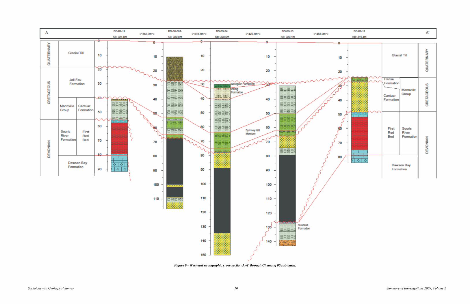
5. Preliminary Interpretations Figure 8 lists the lithological units depicted in each drill hole of the cross sections. Cross-section A-A' (Figure 9) is a west-east transect of what Goldsource has termed the Chemong 06 sub-basin (Figure 1) and clearly shows a basinal structure with the carbonaceous units increasing in depth and thickness toward the centre of the sub-basin. The flanks of the sub-basin show Devonian strata of the Souris River and Dawson Bay formations occurring at similar depths and with similar thicknesses. In both cases, the Devonian strata are overlain by relatively thin intervals of Cantuar Formation, both lacking any significant coal deposits.
Thickness of the Cantuar Formation, and its corresponding coal intervals, appears to increase toward the centre of the sub-basin. These significant thicknesses of the Cantuar Formation would have accumulated by filling pre-existing accommodation space. Potential mechanisms for the creation of this accommodation space are discussed below. Because no Devonian strata were encountered within this sub-basin, it can be assumed that its base, prior to Mesozoic deposition, was at least 95 m below the level of surrounding strata. The fact that a greater amount of Colorado Group sediments, specifically Joli Fou Formation and its Spinney Hill Member, are preserved within the sub-basin, may imply post-depositional subsidence prior to the next significant erosion. The preservation of the Viking and Westgate formations in the centre of the sub-basin (BD-09-24) may have resulted from continued subsidence during the late Albian.

Saskatchewan Geological Survey 9 Summary of Investigations 2009, Volume 2
Figure 8 - Legend of lithologies used in cross sections.
Significant subsidence would not be unexpected during maturation of the coal and would also account for the general down-warping observed in most formations within the basin. Ryer and Langer (1980) studied Cretaceous-age coal deposits in Utah and proposed a peat-to-coal compaction ratio ranging from 1.4 to 30:1, with a median compaction ratio of 7:1. Nadon (1998) advocates much lower compaction ratios; in the range of 1.2:1 to 2.2:1. The average amount of coal present in these sub-basins suggests that several metres of compaction, and therefore subsidence, would have been likely with even the most modest of compaction ratios.
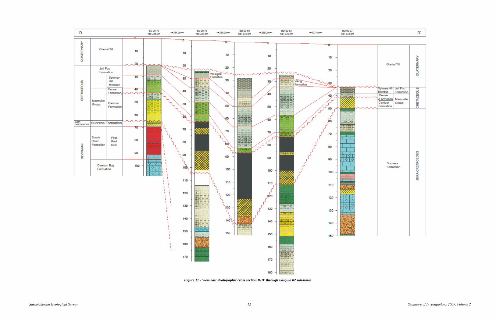
Cross section B-B' (Figure 10) and D-D’ (Figure 11) are approximate south-to-north and west-to-east transects, respectively, through what Goldsource has termed the Pasquia 02 sub-basin (Figure 1). These cross-sections also show a general thickening and down-warping of the Cantuar Formation towards the centre of the sub-basin. Cross-section D-D' shows that the centre of the sub-basin hosts the thickest and deepest sections of Cantuar Formation and the thickest accumulations of coal. The northern and western flanks of the Pasquia 02 sub-basin are underlain by Devonian strata similar to the Chemong 06 sub-basin. Holes drilled at the eastern and southern extents of the Pasquia 02 sub-basin terminate in thick successions of the Success Formation. Unlike the Chemong 06 sub-basin, the base of the Cantuar Formation in the Pasquia 02 sub-basin is well defined by the top of the Success Formation. The base of the Cantuar Formation reaches a maximum depth of approximately 145 m below surface, near the centre of the sub-basin.
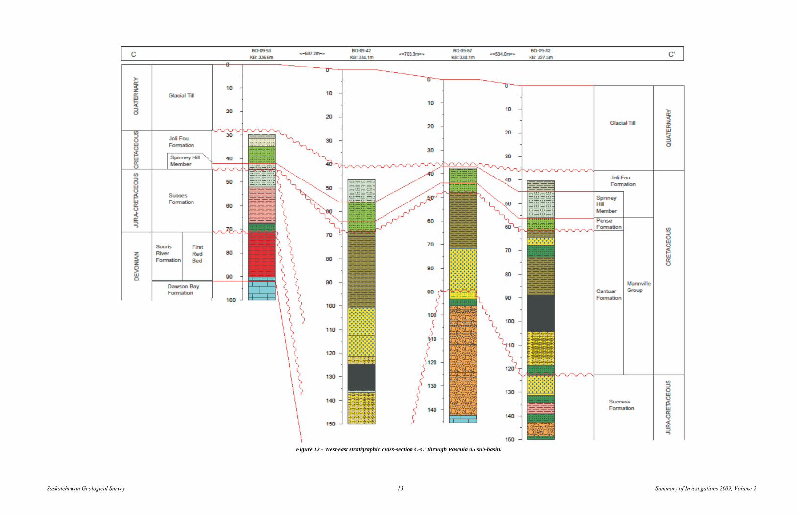
Cross-section C-C' (Figure 12) is a west-to-east transect across what Goldsource has termed the Pasquia 05 sub-basin area (Figure 1). The strata on the west side of this sub-basin dip towards the east initially, but rise towards the east in hole BD-09-57, and dip to the east again in hole BD-09-32. Given this trend in the strata and changes in thickness of coal intercepts in surrounding drill holes, it is possible that this area actually represents two sub-basins, with the western one cresting around the BD-09-57 area, and an eastern one developed east and southeast of drill hole BD-09-32. Additional work is needed in this area to test this hypothesis.
6. Conclusions The Hudson Bay area coal deposits discovered by Goldsource are truly unique. They re-define conventional theories on the depositional environments and types of deposits that occur in our province. These deposits are without analogues in the Mannville, or any other formation, in Saskatchewan. The thickness and localization of these deposits precludes a paralic style of deposition, and suggest more of a limnic depositional environment in which large amounts of peat could have accumulated. Preliminary interpretations suggest that the accommodation space for these deposits was created during Paleozoic time, prior to the deposition of any coal-bearing formations. These paleo-topographic low areas could have provided tens of meters of accommodation space for the deposits to form. A few mechanisms for the creation of this accommodation space have been postulated including: karsting, faulting, and paleo topography created by erosion of the Devonian limestones. The presence of brecciated textures in many of the cores (Figure 13) support the karsting and faulting scenarios, but the successive erosional events that occurred on the Devonian paleo-surface should not be discounted as possible controls on paleo-topography. The authors believe that further work will be required in this area to determine a model for the creation of accommodation space and to explain the accumulation of these anomalously thick coal deposits.
Saskatchewan Geological Survey 10 Summary of Investigations 2009, Volume 2
Figure 9 - West-east stratigraphic cross-section A-A' through Chemong 06 sub-basin.

Saskatchewan Geological Survey 11 Summary of Investigations 2009, Volume 2
Figure 10 - South-north stratigraphic cross-section B-B' through Pasquia 02 sub-basin.
Saskatchewan Geological Survey 12 Summary of Investigations 2009, Volume 2
Figure 11 - West-east stratigraphic cross section D-D' through Pasquia 02 sub-basin.
Saskatchewan Geological Survey 13 Summary of Investigations 2009, Volume 2
Figure 12 - West-east stratigraphic cross-section C-C' through Pasquia 05 sub-basin.

Saskatchewan Geological Survey 14 Summary of Investigations 2009, Volume 2
Figure 13 - Karst collapse or fault breccia in drill hole BD-09-13 at 138.7 m depth.
7. Acknowledgments
The authors would like to thank Goldsource Mines Inc. for its cooperation and collaboration with SMER staff, and for providing unrestricted access to company drill cores and data. We would also like to thank Sean Bosman and Ken Ashton for reviewing earlier versions of this paper.
8. References Baillie, A.D. (1953): Devonian System of the Williston Basin Area; Manitoba Mines Branch, Pub. 52-5. 26p.
Beck, L.S. (1974): Geological Investigations in the Pasquia Hills Area, Saskatchewan; Sask. Dept. Miner. Resour., Rep. 158, 16p.
Bend, S.L. and Frank, M.C. (2004): CO2 sequestration and coalbed-methane potential of lower Mannville Group (Lower Cretaceous) coals, southern Saskatchewan – preliminary investigations; in Summary of Investigations 2004, Volume 1, Saskatchewan Geological Survey, Sask. Industry and Resources, Misc. Rep. 2004-4.1, CD-ROM, Paper A-12, 17p.
Christopher, J.E. (2003): Jura-Cretaceous Success Formation and Lower Cretaceous Mannville Group of Saskatchewan; Sask. Industry and Resources, Misc. Rep. 223, CD-ROM.
Dunn, C.E. (1982): Geology of the Middle Devonian Dawson Bay Formation in the Saskatoon Potash Mining District, Saskatchewan; Sask. Energy Mines, Rep. 194, 117p.
Falini, F. (1965): On the formation of coal deposits of lacustrine origin; Geol. Soc. Amer. Bull., v76, p1317-1346.
Lane, D.M. (1964): Souris River Formation in Southern Saskatchewan; Sask. Dept. Miner. Resour., Rep. 92, 62p.
McNeil, D.H. and Caldwell, W.G.E. (1981): Cretaceous Rocks and Their Foraminifera in the Manitoba Escarpment; Geol. Assoc. Can., Spec. Pap. 21, 439p.
Millard, M.J. (1997): Geology and Groundwater Resources of the Pasquia Hills Area (63E-F), Saskatchewan; Saskatchewan Research Council, Resources and Environmental Group, Publication No. R-1510-2-E-97, 19p.
Nadon, G.C. (1998): Magnitude and timing of peat to coal compaction; Geol. Soc. Amer., v26, no8, p727-730.
Pearson, W.J. (1961): Preliminary Report on Silica Sand and Coal Occurrences on Wapawekka Lake of Northern Saskatchewan; Sask. Dept. Miner. Resour., 18p.
Ryer, T.A. and Langer, A.W. (1980): Thickness change involved in the peat to coal transformation for a bituminous coal of Cretaceous age in central Utah; J. Sediment. Resear., v50, p987-992.
Sandberg, C.A. and Hammond, C.R. (1958): Devonian system in Williston Basin and central Montana; Amer. Assoc. Petrol. Geol. Bull., v42, p2293-2334.
Saskatchewan Geological Survey: (2003): Geology, and Mineral and Petroleum Resources of Saskatchewan; Sask. Industry and Resources, Misc. Rep. 2003-7, 173p.
UP