Embed Size (px)
Citation preview
Division of Environmental Remediation
Preliminary Site Assessment
5565 River Road Site Tonawanda, Erie County, New York
Site Number 915239
August 2012
New York State Department of Environmental Conservation Region 9
270 Michigan Avenue Buffalo, New York 14203
5565 River Road Site August 20, 2012 Preliminary Site Assessment Report Page I
TABLE OF CONTENTS SECTION PAGE 1.0 EXECUTIVE SUMMARY ..................................................................................... 1
2.0 INTRODUCTION.................................................................................................. 5
3.0 SITE HISTORY AND BACKGROUND .............................................................. 7
3.1 SITE DESCRIPTION ......................................................................................................................................... 7 3.2 SITE FEATURES ............................................................................................................................................. 7 3.3 SITE HISTORY & OWNERSHIP ......................................................................................................................... 8 3.4 NEIGHBORING PROPERTIES .......................................................................................................................... 11
4.0 STUDY OBJECTIVES AND ASSESSMENT ACTIVITIES ............................ 12
4.1 OBJECTIVES ................................................................................................................................................. 12 4.2 PRELIMINARY SITE ASSESSMENT ACTIVITIES ................................................................................................. 12 4.2.1 Detailed Property Survey and Mapping ............................................................................................. 13 4.2.2 Site Reconnaissance ............................................................................................................................ 14 4.2.3 Comprehensive Test Pitting Program ................................................................................................. 14 4.2.4 Sample Collection and Analysis .......................................................................................................... 14 4.2.5 Final Site Survey and Mapping ........................................................................................................... 14 4.2.6 Fill Volume Calculations ..................................................................................................................... 15 4.2.7 Report Preparation ............................................................................................................................. 15
5.0 GEOLOGY AND HYDROGEOLOGY ................................................................ 16
5.1 REGIONAL GEOLOGY .................................................................................................................................... 16 5.1.1 Overburden Geology ............................................................................................................................ 16 5.1.2 Bedrock Geology .................................................................................................................................. 17
5.2 SITE GEOLOGY ............................................................................................................................................. 18 5.2.1 NonNative Deposits ............................................................................................................................ 18 5.2.2 Glaciolacustrine Deposit ..................................................................................................................... 19 5.2.3 Bedrock ................................................................................................................................................ 19
5.3 REGIONAL HYDROGEOLOGY .......................................................................................................................... 19 5.4 SITE HYDROGEOLOGY................................................................................................................................... 20
6.0 INVESTIGATION RESULTS ............................................................................ 21
6.1 GENERAL OBSERVATIONS ............................................................................................................................. 22 6.2 SURFACE SOIL ............................................................................................................................................. 23 6.3 INDUSTRIAL FILL ......................................................................................................................................... 24 6.3.1 Foundry Sand ...................................................................................................................................... 25 6.3.2 Flyash ................................................................................................................................................... 26
6.4 DRUM WASTE ............................................................................................................................................. 28 6.5 SURFACE WATER ......................................................................................................................................... 29 6.6 SEDIMENT ................................................................................................................................................... 30 6.7 GROUNDWATER ........................................................................................................................................... 32
5565 River Road Site August 20, 2012 Preliminary Site Assessment Report Page II
7.0 NATURE AND EXTENT OF CONTAMINATION ......................................... 33
7.1 SURFACE SOIL ............................................................................................................................................. 33 7.2 INDUSTRIAL FILL ......................................................................................................................................... 34 7.3 DRUM WASTE ............................................................................................................................................. 36 7.4 SURFACE WATER ......................................................................................................................................... 38 7.5 SEDIMENT ................................................................................................................................................... 38 7.6 GROUNDWATER ........................................................................................................................................... 39
8.0 DISCUSSION AND RECOMMENDATIONS ................................................... 40
8.1 DISCUSSION ................................................................................................................................................ 40 8.1.1 Hazardous Waste Presence ................................................................................................................. 40 8.1.2 Nature and Extent of Contamination ................................................................................................. 41 8.1.3 Potential Responsible Parties ............................................................................................................. 41 8.1.4 Volume of Industrial Fill ..................................................................................................................... 41
8.2 RECOMMENDATIONS .................................................................................................................................... 42
9.0 REFERENCES ..................................................................................................... 43
5565 River Road Site August 20, 2012 Preliminary Site Assessment Report Page III
LIST OF FIGURES (Following Text)
Figure 1‐1 Site location map
Figure 1‐2 Property owner and study area features map
Figure 1‐3 Aerial photograph of the 5565 River Road property
Figure 3‐1 Detailed site map
Figure 4‐1 Proposed test pit location map
Figure 4‐2 Completed test pit location map
Figure 4‐3 Sample location map
Figure 5‐1 Photo showing reworked silty clay overlying foundry sand and native silty clay soils in test pit B‐25
Figure 5‐2 Photo showing reworked and native silty clay soils in test pit A‐34
Figure 5‐3 Close‐up photo of the reworked reddish brown silty clay in test pit A‐22
Figure 5‐4 Photo showing the flyash in test pit I‐28
Figure 5‐5 Photo showing flyash overlying native silty clay soils in test pit G‐25
Figure 5‐6 Photo of the spoils pile from test pit G‐25 showing the homogeneous nature of the flyash
Figure 5‐7 Photo showing the foundry sand in test pit H‐17
Figure 5‐8 Photo showing the foundry sand in test pit DA‐2
Figure 5‐9 Photo of the spoils pile from test pit D‐16 showing debris within the foundry sand
Figure 5‐10 Photo of the spoils pile from test pit D‐18 showing drums and debris within the foundry sand
Figure 5‐11 Foundry sand and flyash location map
Figure 5‐12 Photo showing the darker colored flyash overlying native silty clay soils in test pit G‐28
Figure 5‐13 Photo showing the darker colored flyash overlying native silty clay soils in test pit G‐31
Figure 5‐14 Photo showing the blocky nature of the flyash in the phragmites covered area of the Site
Figure 5‐15 Close‐up photo showing the reddish brown coating on blocky flyash pieces
Figure 5‐16 Photo showing the native silty clay soil in test pit B‐4
Figure 5‐17 Close‐up photo showing the native silty clay soil in test pit B‐4
5565 River Road Site August 20, 2012 Preliminary Site Assessment Report Page IV
LIST OF FIGURES (continued)
Figure 5‐18 Photo of groundwater that flowed into test pit B‐13
Figure 5‐19 Photo of groundwater that flowed into test pit DA‐3
Figure 5‐20 Photo of groundwater that flowed into test pit G‐44
Figure 5‐21 Photo showing groundwater flowing into test pit E‐8 at the fill/native interface
Figure 5‐22 Photo showing groundwater flowing into test pit G‐12 at the fill/native interface
Figure 5‐23 Close‐up photo showing groundwater flowing into test pit G‐22 at the fill/native interface
Figure 6‐1 Photo showing the vegetation across the northern portion of the Site
Figure 6‐2 Photo showing the vegetation on the northern portion of the fill ridge along the west Site boundary
Figure 6‐3 Photo showing the vegetation at Drum Area 3
Figure 6‐4 Photo showing the vegetation at Drum Area 2
Figure 6‐5 Photo showing the vegetation on the southern portion of the fill ridge along the west Site boundary
Figure 6‐6 Photo showing an ATV trail in the northern portion of the Site
Figure 6‐7 Photo showing an ATV trail and exposed industrial fill in the northern portion of the Site
Figure 6‐8 Photo showing the southern portion of the fill ridge adjacent to the middle creek
Figure 6‐9 Photo showing two of the drums near the north property line
Figure 6‐10 Photo showing two of the drums near the north property line
Figure 6‐11 Photo showing one of the drums near the north property line
Figure 6‐12 Photo showing one of the drums in the middle creek
Figure 6‐13 Photo showing three of the drums in the middle creek
Figure 6‐14 Photo showing one of the drums in Drum Area 6
Figure 6‐15 Photo showing an area of stressed vegetation at the Site
Figure 6‐16 Photo showing an area of stressed vegetation at the Site
Figure 6‐17 Photo showing an area of stressed vegetation at the Site
Figure 6‐18 Photo showing a drum encountered in test pit B‐19 and the liquid that spilled from it
5565 River Road Site August 20, 2012 Preliminary Site Assessment Report Page V
LIST OF FIGURES (continued)
Figure 6‐19 Close‐up photo of the liquid that spilled from the drum encountered in test pit B‐19
Figure 6‐20 Photo showing a drum encountered in test pit B‐19 and the sludge it contained
Figure 6‐21 Close‐up photo of one of the drums encountered in test pit D‐18
Figure 6‐22 Photo showing a drum encountered in test pit H‐17 and the sludge that spilled from it
Figure 6‐23 Photo showing the drums encountered in test pit H‐17
Figure 6‐24 Photo showing the drums encountered in test pit I‐10
Figure 6‐25 Photo showing the drum encountered in test pit J‐30 and the waste within it
Figure 7‐1 Unrestricted soil cleanup objective exceedance map
Figure 7‐2 Commercial soil cleanup objective exceedance map
Figure 7‐3 Map Showing test pits with subsurface drums
Figure 7‐4 Commercial exceedance map for drum waste samples
Figure 7‐5 Surface water & sediment criteria exceedance map
Figure 8‐1 Hazardous waste map
LIST OF TABLES (Following Figures)
Table 4‐1 Summary Key for Samples Collected During the 2011 Preliminary Site Assessment
Table 5‐1 Stratigraphic Sequence of the Western New York Area
Table 6‐1 Analytical Results for Surface Soil Samples Collected During the 2011 Preliminary Site Assessment
Table 6‐2A Analytical Results for Subsurface Foundry Sand Samples Collected During the 2011 Preliminary Site Assessment
Table 6‐2B Analytical Results for Subsurface Foundry Sand Samples Collected During the 2011 Preliminary Site Assessment
Table 6‐3 Analytical Results for Subsurface Flyash Samples Collected During the 2011 Preliminary Site Assessment
Table 6‐4 Analytical Results for Drum Waste Samples Collected During the 2011 Preliminary Site Assessment
5565 River Road Site August 20, 2012 Preliminary Site Assessment Report Page VI
LIST OF TABLES (continued)
Table 6‐5 Analytical Results for Surface Water Samples Collected During the 2011 Preliminary Site Assessment
Table 6‐6 Analytical Results for Sediment Samples Collected During the 2011 Preliminary Site Assessment
LIST OF APPENDICES
Appendix A Site Reconnaissance Report
Appendix B Stratigraphic Summary
Appendix C Test Pit Field Logs
Appendix D Analytical Data
5565 River Road Site August 20, 2012 Preliminary Site Assessment Report Page 1
1.0 EXECUTIVE SUMMARY
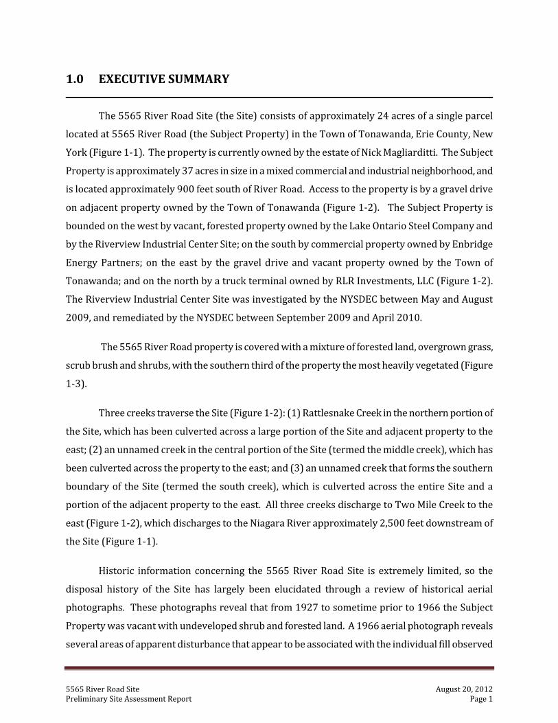
The 5565 River Road Site (the Site) consists of approximately 24 acres of a single parcel
located at 5565 River Road (the Subject Property) in the Town of Tonawanda, Erie County, New
York (Figure 1‐1). The property is currently owned by the estate of Nick Magliarditti. The Subject
Property is approximately 37 acres in size in a mixed commercial and industrial neighborhood, and
is located approximately 900 feet south of River Road. Access to the property is by a gravel drive
on adjacent property owned by the Town of Tonawanda (Figure 1‐2). The Subject Property is
bounded on the west by vacant, forested property owned by the Lake Ontario Steel Company and
by the Riverview Industrial Center Site; on the south by commercial property owned by Enbridge
Energy Partners; on the east by the gravel drive and vacant property owned by the Town of
Tonawanda; and on the north by a truck terminal owned by RLR Investments, LLC (Figure 1‐2).
The Riverview Industrial Center Site was investigated by the NYSDEC between May and August
2009, and remediated by the NYSDEC between September 2009 and April 2010.
The 5565 River Road property is covered with a mixture of forested land, overgrown grass,
scrub brush and shrubs, with the southern third of the property the most heavily vegetated (Figure
1‐3).
Three creeks traverse the Site (Figure 1‐2): (1) Rattlesnake Creek in the northern portion of
the Site, which has been culverted across a large portion of the Site and adjacent property to the
east; (2) an unnamed creek in the central portion of the Site (termed the middle creek), which has
been culverted across the property to the east; and (3) an unnamed creek that forms the southern
boundary of the Site (termed the south creek), which is culverted across the entire Site and a
portion of the adjacent property to the east. All three creeks discharge to Two Mile Creek to the
east (Figure 1‐2), which discharges to the Niagara River approximately 2,500 feet downstream of
the Site (Figure 1‐1).
Historic information concerning the 5565 River Road Site is extremely limited, so the
disposal history of the Site has largely been elucidated through a review of historical aerial
photographs. These photographs reveal that from 1927 to sometime prior to 1966 the Subject
Property was vacant with undeveloped shrub and forested land. A 1966 aerial photograph reveals
several areas of apparent disturbance that appear to be associated with the individual fill observed
5565 River Road Site August 20, 2012 Preliminary Site Assessment Report Page 2
on the property. Dumping on the property appears to have continued through at least 1995. By
2005 dumping appears to have ceased, and trees were starting to grow on the former disposal
areas.
A Phase I Environmental Site Assessment (ESA) of the Subject Property was completed for
the Town of Tonawanda in September 2009. A site reconnaissance completed during the ESA
identified several large mounds of industrial fill (described in more detail in Section 3.2), and 15 to
20 unlabeled 55‐gallon drums in the central portion of the property. While the majority of these
drums were empty, rusted and in poor condition, several drums contained a black, tar‐like
substance.
The New York State Department of Environmental Conservation (NYSDEC) conducted a
Preliminary Site Assessment (PSA) at the Site in 2011 to obtain information sufficient to: (1)
determine if the 5565 River Road Site should be included in the Registry of Inactive Hazardous
Waste Disposal Sites In New York State (Registry), and if so, what the appropriate site classification
should be; and (2) determine if the Site is eligible for NYSDEC’s Brownfield Cleanup Program (BCP).
The stratigraphy of the Site was evaluated by examining the stratigraphic logs from test pits
completed during the Preliminary Site Assessment. These logs reveal the presence of clean fill
(thicknesses ranging from 0.4 to 9.0 feet), industrial fill (thicknesses ranging from 0.5 to 16.0 feet)
and native silty clay soils at the Site. Clean fill consisted predominantly of reworked, native silty
clay soil with trace amounts of brick, concrete, gravel and wood. Industrial fill consisted of
homogeneous flyash or foundry sand containing drums, wood, metal and garbage. Flyash is the
predominant fill type in the north‐central portion of the Site.
Saturated soil/fill was not encountered at thicknesses sufficient to justify the installation of
micro‐wells. As a result, the hydrogeology of the 5565 River Road Site was not evaluated during
the Preliminary Site Assessment.
The results of the Preliminary Site Assessment indicate that surface soil at the Site contains
volatile organic compounds, semivolatile organic compounds, pesticides, polychlorinated biphenyls
(PCBs) and metals. Concentrations of methylene chloride, toluene, xylene, endrin, heptachlor,
PCBs, and the EPA priority pollutant metals arsenic, cadmium, chromium, copper, lead, mercury,
nickel and zinc exceeded the NYSDEC Part 375 unrestricted soil cleanup objectives. Concentrations
of PCBs, arsenic and cadmium also exceeded the NYSDEC Part 375 commercial soil cleanup
5565 River Road Site August 20, 2012 Preliminary Site Assessment Report Page 3
objectives.
Foundry sand at the Site contains volatile organic compounds, semivolatile organic
compounds, PCBs, metals, fuel oil, lube oil, and total petroleum hydrocarbons. Concentrations of
acetone, methylene chloride, toluene, xylene, benzo(a)anthracene, benzo(a)pyrene, benzo(b)
fluoranthene, benzo(k)fluoranthene, chrysene, indeno(1,2,3‐cd)pyrene, PCBs, and the EPA priority
pollutant metals arsenic, cadmium, chromium, copper, lead, mercury, nickel, selenium and zinc
exceeded the NYSDEC Part 375 unrestricted soil cleanup objectives. Concentrations of
benzo(a)anthracene, benzo(a)pyrene, benzo(b)fluoranthene, PCBs, arsenic, cadmium, copper and
nickel also exceeded the NYSDEC Part 375 commercial soil cleanup objectives. Two samples
contained PCBs at concentrations that exceeded the 50 ppm hazardous waste criterion.
Flyash at the Site contains volatile organic compounds, semivolatile organic compounds,
PCBs and metals. Concentrations of methylene chloride, toluene, xylene, (3+4)‐methylphenol,
benzo(a)anthracene chrysene, PCBs, and the EPA priority pollutant metals arsenic, cadmium,
chromium, copper, lead, mercury, nickel, silver and zinc exceeded the NYSDEC Part 375
unrestricted soil cleanup objectives. Concentrations of PCBs, arsenic, cadmium and lead also
exceeded the NYSDEC Part 375 commercial soil cleanup objectives. Barium, a non‐priority
pollutant metal, exceeded the NYSDEC Part 375 unrestricted and commercial soil cleanup
objectives.
Numerous subsurface drums were encountered during the Preliminary Site Assessment,
with the waste from two drums collected for chemical analysis. These wastes included a putty‐like
material from a drum encountered in test pit D‐37 and a pink sludge believed to be paint waste
from a drum encountered in test pit J‐30. Concentrations of 1,2,4‐trimethylbenzene, ethylbenzene,
methylene chloride, toluene, trichloroethene, xylene, naphthalene, PCBs, and the EPA priority
pollutant metals cadmium, chromium, copper, lead, mercury and zinc exceeded the NYSDEC Part
375 unrestricted soil cleanup objectives. Concentrations of 1,2,4‐trimethylbenzene, ethylbenzene,
methylene chloride, toluene, trichloroethene, xylene, PCBs, cadmium, chromium, copper and lead
also exceeded the NYSDEC Part 375 commercial soil cleanup objectives. Sample J‐30 also contained
4‐methyl‐2‐pentanone at a concentration that exceeded Commissioner's Policy CP‐51 protection of
groundwater soil cleanup objective. In addition, both samples contained barium, a non‐priority
pollutant metal, at concentrations that exceeded the NYSDEC Part 375 unrestricted and commercial
soil cleanup objectives. Sample D‐37 contained PCBs at a concentration that exceeded the 50 ppm
5565 River Road Site August 20, 2012 Preliminary Site Assessment Report Page 4
hazardous waste criterion, while sample J‐30 is a characteristic hazardous waste for ignitability
(D001) and lead (D008).
Surface water at the 5565 River Road Site contains volatile organic compounds and metals.
Concentrations of methylene chloride, aluminum and iron exceeded the NYSDEC surface water
standards or guidance values.
Sediment at the Site contains volatile organic compounds, semivolatile organic compounds,
pesticides, PCBs and metals. Concentrations of benzo(a)anthracene, benzo(b)fluoranthene,
benzo(k)fluoranthene, chrysene, indeno(1,2,3‐cd)pyrene, 4,4’‐DDE, PCBs, and the EPA priority
pollutant metals arsenic, cadmium, chromium, copper, lead, nickel and zinc exceeded the NYSDEC
sediment criteria.
The Preliminary Site Assessment conducted at the 5565 River Road Site revealed that a
consequential amount of hazardous waste (PCBs [concentrations >50 ppm], ignitability [D001] and
lead [D008]) is present at the Site. This waste, and other industrial fill, appears to have adversely
impacted sediment in Rattlesnake Creek and the middle creek adjacent to the Site. In addition, the
presence of contaminated surface soil likely poses a public health risk through direct contact with
exposed industrial fill and by inhalation of contaminated dust by ATV users. As a result, it is
recommended that the 5565 River Road Site be listed in the NYSDEC Registry of Inactive
Hazardous Waste Disposal Sites in New York State as a Class 2 site.
5565 River Road Site August 20, 2012 Preliminary Site Assessment Report Page 5
2.0 INTRODUCTION
Between October and December 2011 the NYSDEC conducted a Preliminary Site
Assessment field investigation at the 5565 River Road Site in the Town of Tonawanda, Erie County,
New York (Figure 1‐1). A Phase I Environmental Site Assessment (ESA) conducted at the Site in
2009 by the Town of Tonawanda identified the presence of a significant quantity of industrial fill,
which through erosion, had the potential to impact three on‐Site tributaries to the Niagara River
(Figure 1‐2). The Site is also located within the Town of Tonawanda’s Brownfield Opportunities
Area (BOA). As a result, the Division of Environmental Remediation (DER) conducted a Preliminary
Site Assessment at the 5565 River Road Site to determine if hazardous wastes or substances were
present, and if present, to determine if there was a consequential amount. The Preliminary Site
Assessment was also conducted to determine the degree to which historic waste disposal has
contaminated environmental media at and near the Site. The study results will be utilized to
determine whether the 5565 River Road Site should be included in the Registry, or if the property
is eligible for NYSDEC’s Brownfield Cleanup Program (BCP).
This report summarizes the findings of the Preliminary Site Assessment. The remaining
sections of this report are organized as follows:
# Section 3.0, Site History and Background: This section describes the Site, and
discusses the disposal history and previous investigations completed;
# Section 4.0, Study Objectives and Assessment Activities: This section describes
the objectives of the Preliminary Site Assessment and the activities that were
completed during the investigation;
# Section 5.0, Geology and Hydrogeology: This section describes the regional and
Site geology and hydrogeology. The characteristics, areal extent and hydrogeologic
properties of the strata are discussed;
# Section 6.0, Investigation Results: This section describes the findings of the
Preliminary Site Assessment, including general observations and a summary of the
analytical results obtained from various environmental media (i.e., surface soil,
industrial fill, drum waste, surface water and sediment);
5565 River Road Site August 20, 2012 Preliminary Site Assessment Report Page 6
# Section 7.0, Nature and Extent of Contamination: This section evaluates the
analytical results of the Preliminary Site Assessment to determine the nature and
extent of contamination at the Site;
# Section 8.0, Discussion and Recommendations: This section summarizes the
findings of the Preliminary Site Assessment as they relate to the objectives
presented in Section 4.0. Recommendations for future activities regarding the Site
are also discussed; and
# Section 9.0, References: This section contains a list of references utilized or cited
in the report.
Figures, tables and appendices follow Section 9.0.
5565 River Road Site August 20, 2012 Preliminary Site Assessment Report Page 7
3.0 SITE HISTORY AND BACKGROUND
3.1 Site Description
The 5565 River Road Site occupies the northern 24 acres of a 37 acre parcel at 5565 River
Road in the Town of Tonawanda, Erie County, New York (Figure 1‐1). The Site, located
approximately 900 feet south of River Road, is landlocked; access is by a gravel drive on adjacent
property owned by the Town of Tonawanda (Figure 1‐2). The Subject Property is rectangular in
shape, is zoned for industrial use, and is currently vacant and undeveloped. The proposed future
use of the property is for commercial purposes. The section, block and lot number (SBL) of the
Subject Property is 52.06‐3‐8.
3.2 Site Features
The 5565 River Road property is heavily vegetated by a mixture of trees, tall grass, scrub
brush and shrubs, with the southern third of the property the most heavily vegetated (Figure 1‐3).
The 5565 River Road Site is covered with industrial fill, with the northern and central portions of
the Site containing large mounds of industrial fill that range in height from approximately 5 to 15
feet above the surrounding grade (Figure 3‐1). Exposed fill in these mounds consist predominantly
of flyash containing trace amounts of coal, slag and coke‐like fragments.
The northernmost mound of industrial fill is adjacent to Rattlesnake Creek (Figure 3‐1), a
tributary to Two Mile Creek that discharges to the Niagara River approximately 2,500 feet
downstream of the Site (Figure 1‐1). Storm water run‐off from the mound likely enters Rattlesnake
Creek, and has the potential to adversely impact the Niagara River. A portion of the creek near the
mound is culverted, and discharges into an open channel near Two Mile Creek Road (Figures 1‐2
and 3‐1). An unnamed creek (middle creek) in the south central portion of the Site (Figures 1‐2
and 3‐1), and an unnamed, culverted creek (south creek) at the south end of the Site (Figures 1‐2
and 3‐1) also traverse the property from west to east.
Clusters of surface drums were observed at six different areas of the Site (Figure 3‐1; see
Section 6.1 for more details). The majority of these drums were empty, rusted and in poor
condition, although several drums observed by TVGA during their Phase I Environmental Site
5565 River Road Site August 20, 2012 Preliminary Site Assessment Report Page 8
Assessment reportedly contained a black, tar‐like substance. These drums, however, were not
found during the NYSDEC Preliminary Site Assessment.
Property access is unrestricted, and there are numerous ATV trails running across the
industrial fill (Figure 3‐1).
3.3 Site History & Ownership
Historic information concerning the 5565 River Road Site is extremely limited, so the
disposal history of the Site has largely been elucidated through a review of historical aerial
photographs. In 1927 the Subject Property was vacant with undeveloped shrub and forested land.
A linear disturbed area along the eastern boundary of the property is likely the sewer line that is
currently located along this property line. Rattlesnake Creek, the middle creek and the south creek
are clearly visible. Adjoining properties were vacant with undeveloped agricultural and forested
land.
By 1951 the adjoining property to the northwest was developed with tanks. The Subject
Property and remaining adjoining properties were still undeveloped.
A 1966 aerial photograph reveals several areas of apparent disturbance that appear to be
associated with the industrial fill. Trails on the property are clearly observed, as are Rattlesnake
Creek, the middle creek and the south creek. A nearby property to the east appears to have been
developed as a park (now known as Fireman’s Park), and the tank farm is still present. The
remaining adjoining properties were undeveloped brush and forested land; these properties no
longer appear to be utilized for agricultural purposes.
In 1978 the area of disturbance was larger with the eastern portion of Rattlesnake Creek no
longer visible. Disturbance was observed along the entire length of this creek west of the tank
farm. The middle creek was still clearly visible, but the south creek was not. The adjoining
properties to the north and northeast have been developed as truck terminals, and the tank farm
was still present. The remaining adjoining properties were still undeveloped brush and forested
land.
In 1983 the area associated with the industrial fill was clearly defined. The middle creek
was still clearly visible as was the disturbed land to the south. The tank farm and truck terminals
5565 River Road Site August 20, 2012 Preliminary Site Assessment Report Page 9
were still present. The remaining adjoining properties were still undeveloped brush and forested
land.
In 1995 the area associated with the industrial fill is more distinct. Rattlesnake Creek is
again visible across the Site, but appears to have a straighter course than in previous aerial
photographs. The middle creek was still clearly visible across the Site, but is no longer visible to
the east. The disturbed land south of this creek was more clearly defined, and the south creek is
again visible across the Site. The tank farm and trucking terminals were still present, although only
three tanks remained in the tank farm. The remaining adjoining properties were still undeveloped
brush and forested land.
In 2005 dumping appears to have ceased and trees were starting to grow on the former
disposal areas. The tank farm and truck terminals were still present, although only one large tank
remained in the tank farm. Rattlesnake Creek is visible across the western third of the Site, with
disturbance again observed along the entire length of this creek west of the tank farm. The middle
creek and south creek were still visible across the property. ATV trails running across the
industrial fill were clearly defined.
In 2008 the former disposal areas are more heavily vegetated, and the ATV trails are more
clearly defined. Only a small portion of Rattlesnake Creek in the western portion of the Site was
still visible. The adjoining properties are similar to that in 2005, with the exception that Riverwalk
Parkway (Figures 1‐2 and 1‐3) and the first building in the Riverview Solar Technology Park to the
west have been constructed.
A Phase I Environmental Site Assessment (ESA) was completed by TVGA Consultants for the
Town of Tonawanda in September 2009. A site reconnaissance completed during the ESA
identified the large mounds of industrial fill and drums described in Section 3.2. TVGA reported
that approximately 15 to 20 unlabeled 55‐gallon drums were observed in the center of the site
(believed to be Drum Area 2; Figure 3‐1). As previously stated, a majority of these drums were
empty, rusted and in poor condition, and several contained a black, tar‐like substance. There was
no evidence, however, of stains or leaks on the exterior of the drums or on the ground surface in the
vicinity of the drums.
A records review was completed in 2011 by EmpireGeo Services, Inc. (Empire), a Standby
Investigation & Remediation Contractor to the NYSDEC, during Phase I of the Preliminary Site
5565 River Road Site August 20, 2012 Preliminary Site Assessment Report Page 10
Assessment conducted at the Site. Information obtained from the Town of Tonawanda Assessor’s
office appeared to indicate that the Subject Property was previously part of a larger 48.6 acre
parcel. Records obtained from the Town of Tonawanda Assessor’s office and the Erie County Clerk’s
office indicated previous ownership of the property or nearby parcels by the following entities:
# D.F. Magliarditti (the Subject Property is currently owned by his estate);
# New K Realty, Inc. (James Sandonato) of 1365 Ashland Avenue, Niagara Falls, New York;
# William Strassner;
# Charles J. Rich;
# Merne E. Rich;
# Clayton Rich;
# Berdett Rich;
# L. Franklin Messer; and
# John Strassner.
Information obtained from the Tonawanda Assessor and the Erie County Clerk also
indicated the presence of easements or ownership of small parts of the site or nearby parcels by the
following entities:
# Lakehead Pipeline Company (1967, 1973; including a new oil pumping station in 1998);
# Goetz Oil;
# Shep‐Par Trucking, George Shepherd, President (1972);
# Barbara Miller;
# Intermountain Terminal Company; and
# Town of Tonawanda (easement).
Due to the brief nature of the information on file at the Assessor’s office and the Erie County
Clerk’s office, it is difficult to ascertain the exact property for each transaction. As a result, some of
the entries in these two lists may pertain to parcels that were previously part of the larger
property, or may pertain to nearby parcels.
Empire also completed interviews in 2011 during the Phase I PSA. Empire spoke with Mr.
Hollywood of Pariso, Inc., a trucking company that owns property east of the Site. Mr. Hollywood
5565 River Road Site August 20, 2012 Preliminary Site Assessment Report Page 11
thought that some of the fill materials may have been brought to the Site by Nichter Construction
from the former War Memorial Stadium in Buffalo, New York during the 1970s. He also thought
that it was likely that some of the material may have come from the Niagara Mohawk Power Plant,
located a few miles south on River Road, before their flyash landfill was constructed and opened.
Empire also spoke with Mr. John Podlucky, manager for R&L Carriers, Inc. that is located
between the Site and River Road. Mr. Podlucky indicated that he has been at R&L Carriers for
about 11 years and that he did witness dumping at the Site during that time.
Empire was not able to find a contact for the Lake Ontario Steel Company, Inc., the reputed
owner of the property to the west.
The PSA Site Reconnaissance Report that describes Empire’s findings is included in
Appendix A.
3.4 Neighboring Properties
Properties surrounding the Site are zoned for commercial and industrial use. The adjoining
property to the west is vacant and undeveloped, and consists of a mixture of forested land,
overgrown grass and shrubs. Further west, the Riverview Solar Technology Park is being
developed. The adjoining property to the north is occupied by R&L Carriers, Inc. and is utilized as a
truck terminal. The adjoining property to the south is occupied by a crude oil pipeline pumping
station operated by Enbridge Energy Inc., while the adjoining property to the east is being utilized
for storage of soil, asphalt and concrete piles by Pariso, Inc.
A crude oil pipeline parallels the Subject Property to the west, while a sanitary sewer, storm
sewer and water line parallel the property to the east (Figures 1‐2 and 3‐1).
5565 River Road Site August 20, 2012 Preliminary Site Assessment Report Page 12
4.0 STUDY OBJECTIVES AND ASSESSMENT ACTIVITIES
4.1 Objectives
The overall objective of the Preliminary Site Assessment was to obtain information
sufficient to: (1) determine if the 5565 River Road Site should be included in the Registry, and if so,
what the appropriate site classification should be; and (2) determine if the Site is eligible for
NYSDEC’s Brownfield Cleanup Program. The specific objectives of the PSA were to:
# Evaluate the Site to determine if hazardous wastes or substances are present, and if
present, to determine if there is a consequential amount;
# Determine the nature and extent of contamination at the Site, and determine if the
industrial fill is adversely impacting the three tributaries to the Niagara River;
# Determine the person(s) and/or corporation(s) responsible for the disposal of the
industrial fill; and
# Quantify the volume of industrial fill at the Site.
These objectives were determined through a grided test pitting program, and the analysis of
surface soil, industrial fill, drum waste, surface water and sediment samples collected during the
Preliminary Site Assessment.
4.2 Preliminary Site Assessment Activities
To meet the study objectives, the following activities were completed during the
Preliminary Site Assessment: (1) a detailed property survey; (2) a detailed Site reconnaissance; (3)
a comprehensive test pitting program; (4) collection of environmental samples for chemical
analysis; (5) a final Site survey; (6) fill volume calculations; and (7) report preparation. These
activities are briefly described in the following sections. All field work was conducted in level D
personal protective equipment, while air monitoring for organic vapors was completed during
intrusive activities by EmpireGeo, Inc.
5565 River Road Site August 20, 2012 Preliminary Site Assessment Report Page 13
4.2.1 Detailed Property Survey and Mapping A detailed map of the 5565 River Road Site, including property lines and topography, was
not available prior to the initiation of the Preliminary Site Assessment. As a result, a detailed
property survey was completed during Phase I of the Preliminary Site Assessment by Wm. Schutt
and Associates, P.C. (Schutt), a surveyor licensed in the State of New York. This survey included the
following:
# A topographic survey of the industrial fill mounds and surrounding areas sufficient
to calculate an initial volume of fill at the Site;
# Rattlesnake Creek, the middle creek and the south creek (including the openings of
the concrete and corrugated metal culverts);
# The manholes associated with the sewer line east of the Site;
# The gravel drive east of the Site;
# The stickups identifying the crude oil pipeline west of the Site;
# Other utilities in the vicinity of the Site; and
# The general location of the drum areas found throughout the Site.
Vertical control was established to the nearest ±0.1 foot for all ground surface elevations.
Elevations were determined relative to the North American Vertical Datum of 1988 (NAVD 88),
with reference made to an existing monument in the vicinity of the Subject Property. Horizontal
coordinates were given in the State Plane East Zone (feet), North American Datum (NAD) of 1983
to an accuracy of ±0.5 foot.
Using the detailed property survey as a base map, Schutt established a 50 foot by 50 foot
grid across the Site. This grid was aligned parallel to both the western and northern property lines.
Once the grid was established, Schutt staked each of the proposed test pit locations (Figure 4‐1). In
addition, ground surface elevations were determined at each grid node. Vertical and horizontal
controls were to the datums and accuracies described above.
5565 River Road Site August 20, 2012 Preliminary Site Assessment Report Page 14
4.2.2 Site Reconnaissance Empire conducted a reconnaissance of the Subject Property during Phase I of the
Preliminary Site Assessment to look for evidence of other disposal areas, abandoned drums, spills
etc. that may indicate the presence of additional environmental concerns. The findings of the Site
reconnaissance, included as Appendix A, were incorporated into the test pitting program.
4.2.3 Comprehensive Test Pitting Program During the Preliminary Site Assessment 75 test pits were completed throughout the Site.
The locations of these test pits are shown on Figure 4‐2. The test pits were completed for the
purpose of: (1) visually determining the physical characteristics of the industrial fill; (2) facilitating
the collection of industrial fill samples for chemical analysis; and (3) determining the thickness of
the industrial fill throughout the Site. Each test pit was advanced through the industrial fill until
native soils were encountered.
Based upon visual and/or olfactory evidence, and at the direction of the NYSDEC field
representative, additional test pits were completed to help delineate the areal extent of the
industrial fill encountered during the assessment, or to further evaluate the nature and extent of
contamination associated with the industrial fill.
4.2.4 Sample Collection and Analysis During the Preliminary Site Assessment six (6) surface soil samples, seventeen (17)
subsurface industrial fill samples, two (2) drum waste samples, two (2) surface water samples and
seven (7) sediment samples (Figure 4‐3) were collected and submitted to either TestAmerica in
Amherst, New York or Upstate Laboratories, Inc. in East Syracuse, New York for chemical analysis.
All samples were collected by Empire personnel in consultation with the NYSDEC field
representative. Information concerning sample collection and analysis is given in Table 4‐1.
4.2.5 Final Site Survey and Mapping Following the completion of the Preliminary Site Assessment field activities, Schutt was
tasked to complete final survey activities. These activities included the following:
# Horizontal locations and ground surface elevations of all test pits completed during
the Preliminary Site Assessment that were not completed on the previously
5565 River Road Site August 20, 2012 Preliminary Site Assessment Report Page 15
surveyed grid nodes; and
# Horizontal locations and ground surface elevations of all surface soil, surface water
and sediment samples collected during the investigation.
All test pit and sample locations were added to the base map. Vertical and horizontal
controls were to the datums and accuracies described in Section 4.2.1.
4.2.6 Fill Volume Calculations One of the specific objectives of the Preliminary Site Assessment was to quantify the volume
of industrial fill at the 5565 River Road Site. To accomplish this objective, the elevation of the
native soil below the industrial fill was determined at each test pit location. These elevations were
added to the elevations obtained during the topographic survey and utilized to calculate the volume
of industrial fill at the Site. This calculation was completed by Schutt.
4.2.7 Report Preparation This report was prepared to: (1) describe Site history to the extent that it is known; (2)
describe the field activities completed during the Preliminary Site Assessment; (3) present the
analytical results of the samples collected during the investigation; (4) determine the nature and
extent of contamination at the Site; (5) discuss the results as they relate to the objectives of the
Preliminary Site Assessment; and (6) present recommendations for future activities at the Site.
5565 River Road Site August 20, 2012 Preliminary Site Assessment Report Page 16
5.0 GEOLOGY AND HYDROGEOLOGY
This section describes the regional and Site geology and hydrogeology, along with the
characteristics, areal extent and hydrogeologic properties of the strata near and underlying the
5565 River Road Site.
5.1 Regional Geology
5.1.1 Overburden Geology Geologic evidence suggests that at least four major glacial episodes covered parts of North
America during the Pleistocene Epoch (Buehler and Tesmer, 1963). In western New York,
however, there is evidence of only two such episodes. The last glacial event in the area, the
Wisconsin, eroded and modified the earlier glacial deposits to such an extent that little evidence of
their existence remains. These glacial events widened the preexisting valleys and basins, and led to
the development of the present day drainage system in western New York (La Sala, 1968).
A complex sequence of proglacial lakes that formed during the final retreat of the Wisconsin
ice sheet inundated an extensive area of western New York. This succession originated in the
Erie‐Huron Basin prior to 14,000 years ago as the ice sheet retreated from the basin, and ended
approximately 9,800 year ago with the formation of Lake Tonawanda (Calkins and Brett, 1978).
This lake sequence was responsible for the deposition of the stratified lacustrine clays, silts, sands
and gravels that now cover much of western New York.
The Pleistocene Epoch presented a variety of environments that resulted in the deposition
of unconsolidated deposits. In the Tonawanda area these deposits include the following (Malcolm
Pirnie, 1987; Recra Environmental, 1990; URS, 1992; Woodward‐Clyde, 1993; Conestoga Rovers &
Associates, 1998; Weston, 1998):
# Glacial till consisting of a non‐sorted, non‐stratified mixture of sand, silt, clay, gravel
and rock fragments deposited directly from glacial ice;
# Glaciolacustrine deposits consisting primarily of silt, sand and clay deposited in
lakes that formed during melting and retreat of the ice sheets;
# Glaciofluvial deposits consisting of sand and gravel deposited either by glacial
5565 River Road Site August 20, 2012 Preliminary Site Assessment Report Page 17
meltwater streams or by the reworking of till and other glacial deposits along the
shore of former glacial lakes; and
# Alluvial deposits consisting of silt, sand and gravel deposited by streams during
comparatively recent geologic time.
La Sala (1968) reports that glacial till is the most widespread deposit in the Erie‐Niagara
Basin, ranging in thickness from 2 to 200 feet. Glaciolacustrine clay is also widespread, reaching
thicknesses of 300 feet in some valleys within the basin (La Sala, 1968). Near the 5565 River Road
Site, the glacialacustrine clay is the dominant overburden deposit, ranging in thickness from 55.6 to
88.0 feet at the Ashland 2 FUSRAP Site located approximately 0.25 miles southwest of the Site
(Figure 1‐1).
5.1.2 Bedrock Geology The bedrock underlying western New York is characterized as a thick sequence of shales,
sandstones, limestones and dolostones deposited in ancient seas during the Silurian and Devonian
Periods (Buehler and Tesmer, 1963). This stratigraphic sequence is summarized in Table 5‐1.
Bedrock bedding generally strikes in an east‐west direction, approximately paralleling the Niagara
and Onondaga escarpments, and dips to the south at approximately 30 to 40 feet per mile (Johnson,
1964; La Sala, 1968; Yager and Kappel, 1987). Erosion and weathering, however, have produced
local differences in the bedrock surface configuration (Snyder Engineering, 1987).
The uppermost bedrock formation underlying the 5565 River Road Site is the Camillus
Shale Formation of the Salina Group, which was deposited in a shallow sea environment during the
Late Silurian Period (Rickard and Fisher, 1970). This formation extends across northern Erie
County in an east‐west trending belt approximately 6 to 8 miles wide (Conestoga‐Rovers &
Associates, 1998). Exposures of this formation are rare because of the low relief of the outcrop
area and the mantle of glacial deposits. Buehler and Tesmer (1963, page 30) describe the Camillus
Shale as a "thin bedded shale to massive mudstone. Color is gray or brownish gray with some beds
showing a red or green tinge. Gypsum and anhydrite are present throughout the formation in Erie
County," and occur in beds and lenses up to 5 feet in thickness (La Sala, 1968). Subsurface data
indicate, however, that a considerable quantity of grey limestone and dolostone is interbedded
within the shale (Stanley Consultants, 1981; GZA, 1983; URS, 1992; Woodward‐Clyde, 1993;
Parsons Engineering Science, 1995). The upper 10 to 25 feet of this formation can be heavily
5565 River Road Site August 20, 2012 Preliminary Site Assessment Report Page 18
weathered and often contains abundant bedding planes and vertical fractures enlarged by
dissolution and glacial scour (La Sala, 1968). Buehler and Tesmer (1963) report that the maximum
thickness of the Camillus Shale is 400 feet. Within the Erie‐Niagara Basin, however, the thickness of
this formation ranges from approximately 80 to 100 feet (Rickard, 1966).
5.2 Site Geology
Seventy‐five test pits (Figure 4‐2) were completed during the Preliminary Site Assessment
to evaluate the thickness of the industrial fill throughout the 5565 River Road Site. All test pits
penetrated the industrial fill and were completed in native silty clay soils (the glaciolacustrine
deposit). The stratigraphic logs for these test pits are given in Appendix C, while a stratigraphic
summary of these logs is given in Appendix B.
5.2.1 NonNative Deposits The test pitting program completed during the Preliminary Site Assessment revealed that
two non‐native deposits underlie the 5565 River Road Site: clean fill and industrial fill. Clean fill
was encountered in thirty‐three test pits completed at the Site, and consisted predominantly of
reworked reddish brown silty clay with trace amounts of brick, concrete, gravel and wood (Figures
5‐1 through 5‐3). This fill was most commonly encountered at the ground surface, but was located
beneath the industrial fill at five locations (Table B‐1 of Appendix B). Where encountered, clean fill
ranged in thickness from 0.4 to 9.0 feet (Table B‐1 in Appendix B), with the average thickness being
2.3 feet.
Industrial fill was encountered at fifty‐eight test pits completed at the 5565 River Road Site
(Table B‐1 of Appendix B), and overlies either clean fill or native soil. The industrial fill consisted of
homogeneous dark gray to black flyash (Figures 5‐4 through 5‐6) or foundry sand containing
drums, wood, metal and garbage (Figures 5‐7 through 5‐10). Flyash was the predominant fill
material in the north‐central portion of the Site, while foundry sand was the predominant fill
material to the north and south (Figure 5‐11). The flyash underlying the north‐central portion of
the Site that was heavily vegetated with phragmites (Test pits D‐30, D‐34, E‐27, G‐28 and G‐31; see
Figure 5‐11 for locations) tended to be darker in color and blocky in nature (Figures 5‐12 through
5‐14), with many of the blocks containing a thin brick red coating (Figure 5‐15).
The thickness of the industrial fill ranged from 0.5 to 16.0 feet (Table B‐1 of Appendix B),
5565 River Road Site August 20, 2012 Preliminary Site Assessment Report Page 19
with the average thickness being 6.0 feet. Industrial fill was thickest in the north‐central portion of
the Site where the fill mounds are 5 to 10 feet higher than the surrounding grade. The volume of
industrial fill at the Site was estimated by Schutt as approximately 216,900 cubic yards.
5.2.2 Glaciolacustrine Deposit The native soils underlying the 5565 River Road Site consist predominantly of reddish
brown, brown and tan, very firm to stiff, dry to moist, silty clays (Figures 5‐1, 5‐2, 5‐5, 5‐12, 5‐13, 5‐
16 and 5‐17) that were deposited in the glacial lakes that covered the area during the last ice age.
The glaciolacustrine deposit generally underlies industrial fill, but is occasionally encountered
below a thin topsoil or reworked soil layer (Table B‐1 of Appendix B). The depth to this deposit
ranges from 0.4 to 16.0 feet (Table B‐1 of Appendix B), with the average depth being 5.7 feet.
During the Preliminary Site Assessment only the upper foot or two of this deposit was
excavated, so the thickness of this deposit at the Site is unknown.
5.2.3 Bedrock Bedrock was not encountered during the Preliminary Site Assessment.
5.3 Regional Hydrogeology
Many site investigations and hydrogeologic studies have been completed in the Tonawanda
area. These studies indicate that there are three principal hydrogeologic zones in the area
described as follows:
# The glaciolacustrine silty clay deposit, which can be characterized as an aquitard,
confining groundwater from the underlying Camillus Shale;
# Shallow alluvium, glaciofluvial and fill deposits, which can be characterized as either
unconfined (water table) or perched aquifers; and
# The Camillus Shale bedrock, which can be characterized as a confined aquifer.
In the Tonawanda area, unconfined groundwater is encountered largely within the
glaciofluvial, alluvium and fill deposits. Where these deposits overlie the glaciolacustrine silty clay
deposit, perched groundwater conditions occur. Well yields from these deposits in the Tonawanda
5565 River Road Site August 20, 2012 Preliminary Site Assessment Report Page 20
area are generally unknown, although wells installed in highly permeable outwash deposits in the
Tonawanda Creek valley have yields ranging from 1,000 to 1,400 gallons per minute (gpm) (La
Sala, 1968).
The glaciolacustrine deposit separates the water table and/or perched aquifer from the
confined upper bedrock aquifer. The hydraulic conductivity of this deposit is extremely low,
typically ranging from 10‐6 to 10‐8 cm/s. The glaciolacustrine deposit, therefore, can be considered
an aquitard, preventing the vertical movement of shallow groundwater to the underlying Camillus
Shale. Some vertical movement, however, can occur through desiccation cracks in the upper,
unsaturated portion of this deposit. Horizontal groundwater flow within this deposit is also
severely limited. This deposit, however, often contains thin seams and stringers of silt and sand
that can allow limited horizontal groundwater flow.
Information regarding regional groundwater flow in the upper Camillus Shale bedrock near
the 5565 River Road Site indicates that flow is toward Tonawanda Creek and the Niagara River, the
principal discharge zones in the Tonawanda area (Malcolm Pirnie, 1987; Conestoga‐Rovers &
Associates, 1998; May, 2007).
5.4 Site Hydrogeology
During the Preliminary Site Assessment saturated soil/fill was not encountered at
thicknesses sufficient to justify the installation of micro‐wells, although four test pits filled with
water (Figure 5‐7, and Figures 5‐18 through 5‐20). In general, the test pits remained dry (Figures
5‐1, 5‐2, 5‐4, 5‐5, 5‐12, 5‐13 and 5‐16), but at a few locations groundwater was observed flowing
slowly into the pit at the fill/native soil interface (Figures 5‐21 through 5‐23).
Due to the general absence of groundwater in the fill material and upper glaciolacustrine
deposit, the hydrogeology of the 5565 River Road Site was not evaluated during the Preliminary
Site Assessment. Water level data from the nearby Riverview Industrial Center Site, however,
indicates that groundwater in the area flows north toward the Niagara River. This flow direction is
consistent with fundamental hydrogeologic principles, and observations from other sites along the
Niagara River in the Tonawanda area (e.g., May, 2007).
5565 River Road Site August 20, 2012 Preliminary Site Assessment Report Page 21
6.0 INVESTIGATION RESULTS
A brief description of the activities completed during the Preliminary Site Assessment of the
5565 River Road Site was presented in Section 4.0. In this section, a detailed evaluation of the
observations made during the investigation and the analytical results obtained from the samples
are presented. Analytical results are summarized by environmental media (e.g., surface soil,
industrial fill, drums, surface water and sediment).
For this report, analytical results for surface soil and industrial fill were evaluated against
the unrestricted and commercial soil cleanup objectives of Tables 375‐6.8(a) and 375‐6.8(b)
contained in the December 2006 NYSDEC publication entitled “6NYCRR Part 375: Environmental
Remediation Programs”. The commercial soil cleanup objective was utilized as this is the proposed
future use of the property. For contaminants not included in 6 NYCRR Part 375, the soil cleanup
objectives identified in the October 2010 NYSDEC Commissioner’s Policy CP‐51 entitled “Soil
Cleanup Guidance” were utilized.
The regulatory limits for the hazardous waste characteristics were obtained from the
January 1995 NYSDEC publication entitled “6 NYCRR Part 371: Identification and Listing of
Hazardous Wastes”.
Analytical results for surface water were evaluated against the water quality standards and
guidance values contained in the June 1998 NYSDEC publication entitled “Technical and
Operational Guidance Series (TOGS) 1.1.1: Ambient Water Quality Standards and Guidance Values and
Groundwater Effluent Limitations”. The surface water standards and guidance values for individual
contaminants were taken directly from Table 1.
Sediment criteria were developed from the January 1999 NYSDEC publication entitled
“Technical Guidance for Screening Contaminated Sediments”. This document contains guidance
values for several levels of protection including: (1) human health bioaccumulation, (2) wildlife
bioaccumulation, (3) acute toxicity to benthic aquatic life, and (4) chronic toxicity to benthic
aquatic life. These guidance values are derived using equilibrium partitioning methodology and are
calculated as a function of the organic carbon content of the sediment being evaluated. The average
total organic carbon content of sediment collected during the Preliminary Site Assessment was
8.85%.
5565 River Road Site August 20, 2012 Preliminary Site Assessment Report Page 22
For screening purposes, the sediment criteria to protect benthic aquatic life from chronic
toxicity were utilized. When these criteria were not available for a particular contaminant, the
sediment criteria for human health bioaccumulation were utilized, and if these criteria were not
available, the NYSDEC Part 375 soil cleanup objectives for the protection of ecological resources
were used. For metals, the lowest effect levels from Table 2 of the “Technical Guidance for
Screening Contaminated Sediments” were utilized. When these criteria were not available for a
particular metal, the NYSDEC Part 375 soil cleanup objectives for the protection of ecological
resources were utilized, and if these criteria were not available, the protection of ecological
resources soil cleanup objectives from NYSDEC CP‐51 were used.
6.1 General Observations
The 5565 River Road Site is heavily vegetated by a mixture of trees, tall grass, scrub brush
and shrubs (Figures 6‐1 through 6‐5). Wetland vegetation (e.g., phragmites) was observed in the
north‐central portion of the Site, but free‐standing water was not present in this area during the
Preliminary Site Assessment field activities. No buildings are present on the Site.
While individuals were not observed on Site during the Preliminary Site Assessment
activities, evidence of trespassing was observed (e.g., ATV trails; Figures 6‐6 and 6‐7).
As described in Section 3.2, the Site contains large mounds of industrial fill that range in
height from approximately 5 to 15 feet above the surrounding grade to the west, but slope gently
toward the east. Exposed fill in these mounds consist predominantly of flyash containing trace
amounts of coal, slag and coke‐like fragments. These mounds, however, appear to lie on top of
other industrial fill as a scarp approximately 5 to 6 feet in height was observed along most of the
western boundary of the Site (Figures 3‐1, 6‐2, 6‐3 and 6‐8).
Clusters of empty, 55‐gallon drums were observed on the ground surface throughout the
Site: (1) five empty drums were found near the north property line (Figures 6‐9 through 6‐11;
Drum Area 4 on Figure 3‐1); (2) four empty drums were found in the western portion of the middle
creek in the central portion of the Site (Figures 6‐12 and 6‐13; Drum Area 5 on Figure 3‐1); (3)
approximately 15 to 20 empty drums were observed in the ravine along the culverted portion of
rattlesnake Creek (Drum Area 1 on Figure 3‐1); (4) approximately 10 empty drums were observed
in the central portion of the Site south of the middle creek (Figure 6‐4; Drum Area 2 on Figure 3‐1);
5565 River Road Site August 20, 2012 Preliminary Site Assessment Report Page 23
(5) approximately 10 empty drums were observed along the western bank of the fill ridge south of
the middle creek (Figure 6‐3; Drum Area 3 on Figure 3‐1); and (6) several empty drums along the
southern bank of the fill ridge (Figure 6‐14; Drum Area 6 on Figure 3‐1).
In addition to the exposed industrial fill associated with the ATV trails, exposed industrial
fill was observed at several areas with stressed vegetation (Figure 6‐15 through 6‐17).
6.2 Surface Soil
Six surface soil samples from the 5565 River Road Site were collected during the
Preliminary Site Assessment. The locations of these samples are shown on Figure 4‐3. All samples
consisted of industrial fill, and were collected to evaluate the nature of surface soil contamination
at the Site. Four samples were submitted to TestAmerica Laboratories in Amherst, New York for
chemical analysis, while two samples were submitted to Upstate Laboratories, Inc. in East
Syracuse, New York. Five samples were analyzed for Target Compound List (TCL) semivolatile
organic compounds (SVOCs), TCL pesticides, TCL polychlorinated biphenyls (PCBs) and Target
Analyte List (TAL) metals, with one of the samples also analyzed for TCL volatile organic
compounds (VOCs). The sixth sample was analyzed for TCL PCBs only. The analytical results for
these samples are summarized in Table 6‐1, while information concerning sample collection and
analysis is given in Table 4‐1.
The results of the organic analyses revealed that both volatile and semivolatile organic
compounds were detected in the surface soil samples collected from the 5565 River Road Site
(Table 6‐1). Volatile organic compounds detected in surface soil included methylene chloride (1
sample), toluene (1 sample) and xylene (1 sample). All three contaminants were detected at
concentrations that exceeded the NYSDEC Part 375 unrestricted soil cleanup objectives (Table 6‐1).
None of the concentrations, however, exceeded the NYSDEC Part 375 commercial soil cleanup
objectives (Table 6‐1).
Twenty‐two semivolatile organic compounds were detected in the surface soil samples with
sixteen of these constituents being polycyclic aromatic hydrocarbons (PAHs). PAHs are a group of
over 100 different chemicals that are ubiquitous in the environment. Sources of PAHs include
incomplete combustion of coal, oil, gasoline, garbage, wood from stoves, automobiles and
incinerators. PAHs are also found in coal tar, crude oil, creosote, roofing tar, medicines, dyes,
5565 River Road Site August 20, 2012 Preliminary Site Assessment Report Page 24
plastics and pesticides. Of the semivolatile organic compounds detected, however, none were
detected at concentrations that exceeded the NYSDEC Part 375 or CP‐51 soil cleanup objectives
(Table 6‐1).
The surface soil samples collected from the 5565 River Road Site were also analyzed for
pesticides and PCBs (Table 6‐1). Seven pesticides were detected in these samples with the
concentrations of endrin (1 sample) and heptachlor (2 samples) exceeding the NYSDEC Part 375
unrestricted soil cleanup objectives (Table 6‐1). None of the concentrations, however, exceeded
the NYSDEC Part 375 commercial soil cleanup objectives (Table 6‐1). PCBs were detected in five of
the six samples with all concentrations exceeding the NYSDEC Part 375 unrestricted soil cleanup
objective (Table 6‐1). Four of the concentrations also exceeded the NYSDEC Part 375 commercial
soil cleanup objectives (Table 6‐1).
Sixteen metals were detected in the surface soil samples collected from the 5565 River Road
Site (Table 6‐1). Of these compounds, nine were detected at concentrations that exceeded the
NYSDEC Part 375 unrestricted soil cleanup objectives, with eight of these metals being USEPA
priority pollutant metals. USEPA priority pollutant metals are toxic metals for which
technology‐based effluent limitations and guidelines are required by Federal law. Arsenic (2
samples) and cadmium (1 sample), however, were the only priority pollutant metals that exceeded
the NYSDEC Part 375 commercial soil cleanup objectives (Table 6‐1). In addition, the
concentration of aluminum in three surface soil samples exceeded the CP‐51 soil cleanup objective
for the protection of ecological resources, while the concentration of iron exceeded the CP‐51
residential soil cleanup objective in all five samples analyzed for this contaminant (Table 6‐1).
There are no NYSDEC Part 375 soil cleanup objectives for aluminum and iron.
6.3 Industrial Fill
Seventeen subsurface industrial fill samples were collected from the 5565 River Road Site
during the Preliminary Site Assessment. Eleven of these samples were collected from the foundry
sand, while the remaining six samples were collected from the flyash. The locations of these
samples are shown on Figure 4‐3. All samples were submitted to Upstate Laboratories, Inc. for
chemical analysis of TCL semivolatile organic compounds, TCL pesticides, TCL PCBs and TAL
metals. Sixteen of the samples were also analyzed for TCL volatile organic compounds. Following a
review of the TAL metal results, one industrial fill sample was further analyzed for chromium using
5565 River Road Site August 20, 2012 Preliminary Site Assessment Report Page 25
the Toxicity Characteristic Leaching Procedure (TCLP). One sample was additionally analyzed for
petroleum products and total petroleum hydrocarbons (TPH). The analytical results for the
industrial fill samples are summarized in Tables 6‐2 (foundry sand) and 6‐3 (flyash), while
information concerning sample collection and analysis is given in Table 4‐1.
6.3.1 Foundry Sand The results of the organic analyses revealed that both volatile and semivolatile organic
compounds were detected in the foundry sand samples collected from the 5565 River Road Site
(Tables 6‐2A and 6‐2B). Twelve volatile organic compounds were detected in these samples with
only the concentrations of acetone (2 samples), methylene chloride (5 samples), toluene (2
samples) and xylene (1 sample) exceeding the NYSDEC Part 375 unrestricted soil cleanup
objectives (Tables 6‐2A and 6‐2B). None of the concentrations, however, exceeded the NYSDEC
Part 375 commercial soil cleanup objectives (Tables 6‐2A and 6‐2B). Methylene chloride was also
detected in the associated blank so the presence of this compound in the foundry sand samples is
likely related to laboratory contamination.
Twenty‐three semivolatile organic compounds were detected in the foundry sand samples
(Tables 6‐2A and 6‐2B) with fifteen of these constituents being polycyclic aromatic hydrocarbons.
Of the PAH compounds, benzo(a)anthracene (3 samples), benzo(a)pyrene (2 samples), benzo(b)
fluoranthene (3 samples), benzo(k)fluoranthene (1 sample), chrysene (3 samples) and indeno
(1,2,3‐cd)pyrene (1 sample) were detected at concentrations that exceeded the NYSDEC Part 375
unrestricted soil cleanup objectives (Tables 6‐2A and 6‐2B). The concentrations of
benzo(a)anthracene, benzo(a)pyrene and benzo(b)fluoranthene in sample D‐41, and benzo(a)
pyrene in sample DA‐2 also exceeded the NYSDEC Part 375 commercial soil cleanup objectives
(Tables 6‐2A and 6‐2B).
Phthalates [bis(2‐ethylhexyl)phthalate and di‐n‐butylphthalate] were also detected in the
foundry sand samples collected from the Site (Tables 6‐2A and 6‐2B). None of the concentrations,
however, exceeded the NYSDEC CP‐51 residential soil cleanup objectives. There are no NYSDEC
Part 375 soil cleanup objectives for these contaminants. Biphenyl (5 samples), caprolactum (1
sample), carbazole (3 samples), dibenzofuran (5 samples), 2,4‐dimethylphenol (3 samples) and
(3+4)‐methylphenol (1 sample) were also detected in the foundry sand samples. None of the
5565 River Road Site August 20, 2012 Preliminary Site Assessment Report Page 26
concentrations, however, exceeded the NYSDEC Part 375 soil cleanup objectives (Tables 6‐2A and
6‐2B).
The foundry sand samples collected from the 5565 River Road Site were also analyzed for
pesticides and PCBs (Tables 6‐2A and 6‐2B). No pesticides were detected in these samples, while
PCBs were detected in all eleven samples at concentrations that exceeded both the NYSDEC Part
375 unrestrictive and commercial soil cleanup objectives. In addition, two samples (D‐41 and I‐10;
Figure 4‐3) contained PCBs at concentrations that exceeded the 50 ppm hazardous waste criterion
(Tables 6‐2A and 6‐2B).
Sixteen metals were detected in the foundry sand samples collected from the 5565 River
Road Site (Tables 6‐2A and 6‐2B). Of these compounds, ten were detected at concentrations that
exceeded the NYSDEC Part 375 unrestricted soil cleanup objectives, with nine of these metals being
USEPA priority pollutant metals. Arsenic, cadmium, copper and nickel concentrations in sample
DA‐2 were the only priority pollutant metals that exceeded the NYSDEC Part 375 commercial soil
cleanup objectives (Tables 6‐2A and 6‐2B). In addition, the concentration of aluminum in two
foundry sand samples exceeded the CP‐51 soil cleanup objective for the protection of ecological
resources, while the concentration of iron exceeded the CP‐51 residential soil cleanup objective in
all eleven samples (Tables 6‐2A and 6‐2B). There are no NYSDEC Part 375 soil cleanup objectives
for aluminum and iron.
Following a review of the TAL metal results, the sample from test pit DA‐2 was analyzed for
chromium using the Toxicity Characteristic Leaching Procedure. The TCLP chromium result for
this sample is summarized in Table 6‐2B, and reveals that the foundry sand from test pit DA‐2 is
not a characteristic hazardous waste for chromium.
The foundry sand sample from test pit G‐44 was also analyzed for petroleum products and
TPH. These analyses revealed the presence of fuel oil, lube oil and TPH (Table 6‐2A). There are no
NYSDEC Part 375 soil cleanup objectives for these contaminants.
6.3.2 Flyash The results of the organic analyses revealed that both volatile and semivolatile organic
compounds were detected in the flyash samples collected from the 5565 River Road Site (Table 6‐
3). Methylene chloride (4 samples), toluene (2 samples) and xylene (1 sample) were the only
5565 River Road Site August 20, 2012 Preliminary Site Assessment Report Page 27
volatile organic compounds detected in these samples, with all concentrations exceeding the
NYSDEC Part 375 unrestricted soil cleanup objectives (Table 6‐3). None of the concentrations,
however, exceeded the NYSDEC Part 375 commercial soil cleanup objectives (Table 6‐3).
Fourteen semivolatile organic compounds were detected in the flyash samples (Table 6‐3)
with seven of these constituents being polycyclic aromatic hydrocarbons. Of the PAH compounds,
only benzo(a)anthracene (1 sample) and chrysene (1 sample) were detected at concentrations that
exceeded the NYSDEC Part 375 unrestricted soil cleanup objectives (Table 6‐3). None of the
concentrations exceeded the NYSDEC Part 375 commercial soil cleanup objectives (Table 6‐3).
Phthalates [bis(2‐ethylhexyl)phthalate and di‐n‐butylphthalate] were also detected in the
flyash samples collected from the Site (Table 6‐3). None of the concentrations, however, exceeded
the NYSDEC CP‐51 residential soil cleanup objectives (Table 6‐3). There are no NYSDEC Part 375
soil cleanup objectives for these contaminants. Biphenyl, dibenzofuran, 4‐chloroaniline,
2,4‐dimethylphenol and (3+4)‐methylphenol were also detected in the flyash sample collected from
test pit E‐27 (see Figure 4‐3 for location). Only the concentration of (3+4)‐methylphenol exceeded
the NYSDEC Part 375 unrestricted soil cleanup objectives (Table 6‐3). This concentration,
however, did not exceed the NYSDEC Part 375 commercial soil cleanup objective (Table 6‐3).
The flyash samples collected from the 5565 River Road Site were also analyzed for
pesticides and PCBs (Table 6‐3). No pesticides were detected in these samples, while PCBs were
detected in all six samples. The concentrations of PCBs in two samples exceeded both the NYSDEC
Part 375 unrestrictive and commercial soil cleanup objectives.
Sixteen metals were detected in the flyash samples collected from the 5565 River Road Site
(Table 6‐3). Of these compounds, eleven were detected at concentrations that exceeded the
NYSDEC Part 375 unrestricted soil cleanup objectives, with nine of these metals being USEPA
priority pollutant metals. Concentrations of arsenic (4 samples), cadmium (1 sample) and lead (1
sample) also exceeded the NYSDEC Part 375 commercial soil cleanup objectives (Table 6‐3).
Barium, a non‐priority pollutant metal, exceeded the NYSDEC Part 375 unrestricted and
commercial soil cleanup objectives. In addition, the concentration of aluminum in four flyash
samples exceeded the CP‐51 soil cleanup objective for the protection of ecological resources, while
the concentration of iron exceeded the CP‐51 residential soil cleanup objective in all six samples
(Table 6‐3). There are no NYSDEC Part 375 soil cleanup objectives for aluminum and iron.
5565 River Road Site August 20, 2012 Preliminary Site Assessment Report Page 28
6.4 Drum Waste
In addition to the surface drums discussed in Section 6.1, numerous drums were
encountered during the completion of the test pitting program (Figure 5‐10, and Figures 6‐18
through 6‐25). Two drum waste samples were collected during the Preliminary Site Assessment
for chemical analysis. These wastes included a putty‐like material from a drum encountered in test
pit D‐37 and a pink sludge believed to be paint waste from a drum encountered in test pit J‐30
(Figure 6‐25). The locations of the test pits are shown on Figure 4‐2. Both samples were submitted
to Upstate Laboratories, Inc. for chemical analysis of TCL volatile organic compounds, TCL
semivolatile organic compounds, TCL pesticides, TCL PCBs and TAL metals. The drum waste
sample from test pit D‐37 was further analyzed for barium and lead using the Toxicity
Characteristic Leaching Procedure, while the drum waste sample from test pit J‐30 was further
analyzed for barium, chromium and lead using TCLP. The drum waste sample from test pit J‐30
was also analyzed for ignitability. The analytical results for the drum waste samples are
summarized in Table 6‐4, while information concerning sample collection and analysis is given in
Table 4‐1.
The results of the organic analyses revealed that both volatile and semivolatile organic
compounds were detected in the drum waste samples collected from the 5565 River Road Site
(Table 6‐4). Eight volatile organic compounds were detected in these samples with the
concentrations of 1,2,4‐trimethylbenzene (sample J‐30), ethylbenzene (sample J‐30), methylene
chloride (both samples), toluene (sample J‐30), trichloroethene (sample J‐30) and xylene (both
samples) exceeding the NYSDEC Part 375 unrestricted soil cleanup objectives (Table 6‐4).
Concentrations of 1,2,4‐trimethylbenzene, ethylbenzene, methylene chloride, toluene,
trichloroethene and xylene in sample J‐30 also exceeded the NYSDEC Part 375 commercial soil
cleanup objectives (Table 6‐4). The concentration of 4‐methyl‐2‐pentanone in sample J‐30
exceeded the CP‐51 soil cleanup objective for the protection of groundwater (Table 6‐4). There are
no NYSDEC Part 375 soil cleanup objectives for 4‐methyl‐2‐pentanone and methylcyclohexane.
Both drum waste samples also contained tentatively identified VOC compounds at total
concentrations of 15.82 ppm (D‐37) and 53,700 ppm (J‐30).
Naphthalene was the only semivolatile organic compounds detected in the drum waste
samples with the concentration in sample J‐30 exceeding the NYSDEC Part 375 unrestricted soil
cleanup objectives (Table 6‐4). This concentration, however, did not exceed the NYSDEC Part 375
5565 River Road Site August 20, 2012 Preliminary Site Assessment Report Page 29
commercial soil cleanup objective (Table 6‐4). Both samples also contained tentatively identified
SVOC compounds at total concentrations of 20,400 ppm (D‐37) and 820 ppm (J‐30).
The drum waste samples collected from the 5565 River Road Site were also analyzed for
pesticides and PCBs (Tables 6‐4). No pesticides were detected in these samples, while PCBs were
detected in both samples at concentrations that exceeded both the NYSDEC Part 375 unrestrictive
and commercial soil cleanup objectives. Sample D‐37 contained PCBs at a concentration that
exceeded the 50 ppm hazardous waste criterion (Tables 6‐4).
Thirteen metals were detected in the drum waste samples collected from the 5565 River
Road Site (Table 6‐4). Of these compounds, seven were detected at concentrations that exceeded
the NYSDEC Part 375 unrestricted soil cleanup objectives, with six of these metals being USEPA
priority pollutant metals. Concentrations of cadmium (sample J‐30), chromium (sample J‐30),
copper (sample D‐37) and lead (both samples) also exceeded the NYSDEC Part 375 commercial soil
cleanup objectives (Table 6‐4). Barium, a non‐priority pollutant metal, exceeded the NYSDEC Part
375 unrestricted and commercial soil cleanup objectives in both samples. In addition,
concentrations of iron in both samples exceeded the CP‐51 residential soil cleanup objective (Table
6‐4). There are no NYSDEC Part 375 soil cleanup objectives for iron.
Following a review of the TAL metal results, both samples were analyzed for barium,
chromium and/or lead using the Toxicity Characteristic Leaching Procedure. The TCLP results are
summarized in Table 6‐4, and reveal that drum waste sample J‐30 is a characteristic hazardous
waste for lead (D008).
Drum waste sample J‐30 was also analyzed for ignitability due to the high PID readings
recorded in the field. This analysis (Table 6‐4) revealed that the drum waste is also a characteristic
hazardous waste for ignitability (D001).
6.5 Surface Water
Two surface water samples from the 5565 River Road Site were collected during the
Preliminary Site Assessment. One sample was collected from Rattlesnake Creek near Two Mile
Creek Road, while the second sample was collected from the middle creek where it exits the Site.
The locations of these samples are shown on Figure 4‐3. The October 2011 sample was submitted
to TestAmerica Laboratories for chemical analysis of TCL volatile organic compounds, TCL
5565 River Road Site August 20, 2012 Preliminary Site Assessment Report Page 30
semivolatile organic compounds, TCL pesticides, TCL PCBs and TAL metals, while the December
2011 sample was submitted to Upstate Laboratories, Inc. for chemical analysis of TCL volatile
organic compounds, TCL semivolatile organic compounds, TCL pesticides, TCL PCBs and TAL
metals. The analytical results for these samples are summarized in Table 6‐5, while information
concerning sample collection and analysis is given in Table 4‐1.
The results of the organic analyses revealed that methylene chloride (1 sample) was the
only volatile organic compound detected in the surface water samples collected from the 5565
River Road Site (Table 6‐5). The concentration of this compound exceeded the NYSDEC surface
water standard for this contaminant (Table 6‐5). Semivolatile organic compounds, pesticides and
PCBs were not detected in either surface water sample.
Six metals were detected in the surface water samples collected from the 5565 River Road
Site (Table 6‐5). Of these compounds, only aluminum and iron in the middle creek sample were
detected at concentrations that exceeded the NYSDEC surface water standards. Neither metal is an
EPA priority pollutant metal.
6.6 Sediment
Seven sediment samples from the 5565 River Road Site were collected during the
Preliminary Site Assessment. Three samples were collected from Rattlesnake Creek (one upstream,
one adjacent and one downstream), while the remaining four samples were collected from the
middle creek (one upstream, two adjacent and one downstream). The locations of these samples
are shown on Figure 4‐3. The October 2011 sample was submitted to TestAmerica Laboratories for
chemical analysis of TCL semivolatile organic compounds, TCL pesticides, TCL PCBs and TAL
metals, while the December 2011 samples were submitted to Upstate Laboratories, Inc. for
chemical analysis of TCL volatile organic compounds, TCL semivolatile organic compounds, TCL
pesticides, TCL PCBs, TAL metals and total organic carbon (TOC). The analytical results for these
samples are summarized in Table 6‐6, while information concerning sample collection and analysis
is given in Table 4‐1.
The results of the organic analyses revealed that acetone was the only volatile organic
compound detected in the sediment samples collected from the 5565 River Road Site (Table 6‐6).
None of the concentrations, however, exceeded the NYSDEC sediment criteria (Table 6‐6).
5565 River Road Site August 20, 2012 Preliminary Site Assessment Report Page 31
Twenty‐three semivolatile organic compounds were detected in the sediment samples with
sixteen of these constituents being polycyclic aromatic hydrocarbons. Of the PAH compounds,
benzo(a)anthracene (1 sample), benzo(b)fluoranthene (4 samples), benzo(k)fluoranthene (1
sample), chrysene (5 samples) and indeno(1,2,3‐cd)pyrene (2 samples) were detected at
concentrations that exceeded the NYSDEC sediment criteria (Table 6‐6).
Bis(2‐ethylhexyl)phthalate was also detected in the sediment samples collected from the
Site (Table 6‐6). None of the concentrations, however, exceeded the NYSDEC sediment criteria
(Table 6‐6). Dibenzofuran (3 samples), 2,4‐dimethylphenol (2 samples), 2‐methylphenol (1
sample), (3+4)‐methylphenol (2 samples) and 1,2,4,5‐tetrachlorobenzene (1 sample) were also
detected in the sediment samples (Table 6‐6). There are no NYSDEC sediment criteria for these
contaminants.
The sediment samples collected from the 5565 River Road Site were also analyzed for
pesticides and PCBs (Table 6‐6). 4,4'‐DDE (sample SED‐2) was the only pesticide detected in
sediment at the Site, with the concentration exceeding the NYSDEC sediment criteria (Table 6‐6).
PCBs were detected in all seven sediment samples, with the concentrations in three samples
exceeding the NYSDEC sediment criteria (Table 6‐6).
Fifteen metals were detected in the sediment samples collected from the 5565 River Road
Site (Table 6‐6). Of these compounds, nine were detected at concentrations that exceeded the
NYSDEC sediment criteria, with seven of these metals being EPA priority pollutant metals. The
priority pollutant metals exceeding the sediment criteria included arsenic (4 samples), cadmium (7
samples), chromium (5 samples), copper (6 samples), lead (7 samples), nickel (6 samples) and zinc
(3 samples). The non‐priority pollutant metals exceeding the sediment criteria included iron (6
samples) and manganese (7 samples). In addition, the concentrations of aluminum (5 samples)
and vanadium (4 samples) exceeded the CP‐51 soil cleanup objectives for the protection of
ecological resources (Table 6‐6).
Six of the seven sediment samples collected from the 5565 River Road Site were analyzed
for total organic carbon (TOC). These results, summarized in Table 6‐6, were utilized to calculate
sediment criteria for the Site. TOC concentrations ranged from 4.2% to 15.0%.
5565 River Road Site August 20, 2012 Preliminary Site Assessment Report Page 32
6.7 Groundwater
As discussed in Section 5.4, saturated conditions were not encountered at frequencies and
thicknesses sufficient to justify the installation of micro‐wells. As a result, groundwater samples
were not collected from the 5565 River Road Site during the Preliminary Site Assessment.
5565 River Road Site August 20, 2012 Preliminary Site Assessment Report Page 33
7.0 NATURE AND EXTENT OF CONTAMINATION
The results of the 2011 NYSDEC Preliminary Site Assessment of the 5565 River Road Site
were discussed in Section 6.0. In this section, those results are evaluated to determine the nature
and extent of contamination at the Site.
7.1 Surface Soil
Six surface soil samples were collected from the 5565 River Road Site during the
Preliminary Site Assessment to evaluate direct contact exposures to contaminated surface soil. The
locations of these samples are shown on Figure 4‐3. A detailed discussion of the analytical results
from these samples was included in Section 6.2. In summary, all six samples contained
contaminants at concentrations that exceeded the NYSDEC Part 375 soil cleanup objectives. These
exceedances are summarized in Table 6‐1, and illustrated on Figures 7‐1 (unrestricted
exceedances) and 7‐2 (commercial exceedances).
Three volatile organic compounds were detected in the surface soil samples collected from
the Site at concentrations that exceeded the NYSDEC Part 375 unrestricted soil cleanup objectives
(Table 6‐1). These VOCs (with the number of exceedances and maximum concentrations) included
methylene chloride (1 sample; 1.0 mg/kg), toluene (1 sample; 2.8 mg/kg) and xylene (1 sample;
0.72 mg/kg). None of the concentrations, however, exceeded the NYSDEC Part 375 commercial soil
cleanup objectives (Table 6‐1).
Two pesticides were detected in the surface soil samples collected from the 5565 River
Road Site at concentrations that exceeded the NYSDEC Part 375 unrestricted soil cleanup objectives
(Table 6‐1). These pesticides (with the number of exceedances and maximum concentrations)
included endrin (1 sample; 0.13J mg/kg) and heptachlor (2 samples; 0.42 mg/kg). None of the
concentrations, however, exceeded the NYSDEC Part 375 commercial soil cleanup objectives (Table
6‐1).
PCBs were detected in five of the six surface soil samples collected from the Site, with all
concentrations exceeding the NYSDEC Part 375 unrestricted soil cleanup objectives (Table 6‐1).
The maximum concentration of total PCBs was 31J mg/kg in sample SS‐4 (see Figure 4‐3 for
5565 River Road Site August 20, 2012 Preliminary Site Assessment Report Page 34
location). Concentrations of PCBs in four samples also exceeded the NYSDEC Part 375 commercial
soil cleanup objectives (Table 6‐1; Figure 7‐2).
Eight EPA priority pollutant metals were detected in the surface soil samples collected from
the 5565 River Road Site at concentrations that exceeded the NYSDEC Part 375 unrestricted soil
cleanup objectives (Table 6‐1). These metals (with the number of exceedances and maximum
concentrations) included arsenic (2 samples; 51.8 mg/kg), cadmium (2 samples; 9.97 mg/kg),
chromium (4 samples; 354 mg/kg), copper (3 samples; 145 mg/kg), lead (3 samples; 373 mg/kg),
mercury (1 sample; 0.26 mg/kg), nickel (3 samples; 105 mg/kg) and zinc (4 samples; 1,040
mg/kg). Concentrations of arsenic (2 samples) and cadmium (1 sample) also exceeded the NYSDEC
Part 375 commercial soil cleanup objectives (Table 6‐1; Figure 7‐2). In addition, concentrations of
aluminum (3 samples; 13,700 mg/kg) exceeded the CP‐51 soil cleanup objective for the protection
of ecological resources, while concentrations of iron (5 samples; 83,400 mg/kg) exceeded the CP‐
51 residential soil cleanup objective (Table 6‐1). There are no NYSDEC Part 375 soil cleanup
objectives for aluminum and iron.
As illustrated by Figure 7‐1, all surface soil samples collected from the 5565 River Road Site
exceeded the NYSDEC Part 375 unrestricted soil cleanup objectives. These samples are located
throughout the Site, and were collected from exposed fill along the ATV trails (SS‐1 through SS‐4)
or from areas devoid of vegetation (SS‐5) to evaluate worst case direct contact exposures. Figure 7‐
2 reveals that all surface soil samples also exceeded the NYSDEC Part 375 commercial soil cleanup
objectives. Commercial exceedances were documented for PCBs, arsenic and cadmium.
7.2 Industrial Fill
Seventeen subsurface industrial fill samples were collected from the 5565 River Road Site
during the Preliminary Site Assessment to evaluate the nature and extent of contamination at the
Site. Eleven of these samples were collected from foundry sand, while the remaining six samples
were collected from flyash. The locations of these samples are shown on Figure 4‐3. A detailed
discussion of the analytical results from these samples was included in Section 6.3. In summary, all
seventeen samples contained contaminants at concentrations that exceeded the NYSDEC Part 375
soil cleanup objectives. These exceedances are summarized in Tables 6‐2 and 6‐3, and illustrated
on Figures 7‐1 (unrestricted exceedances) and 7‐2 (commercial exceedances).
5565 River Road Site August 20, 2012 Preliminary Site Assessment Report Page 35
Four volatile organic compounds were detected in the industrial fill samples collected from
the Site at concentrations that exceeded the NYSDEC Part 375 unrestricted soil cleanup objectives
(Tables 6‐2 and 6‐3). These compounds (with the number of exceedances and maximum
concentrations) included acetone (2 samples; 0.46 mg/kg), methylene chloride (9 samples; 1.2
mg/kg), toluene (4 samples; 5.2 mg/kg) and xylene (2 samples; 1.3 mg/kg). None of the
concentrations, however, exceeded the NYSDEC Part 375 commercial soil cleanup objectives
(Tables 6‐2 and 6‐3). Methylene chloride was also detected in the associated blank so the presence
of this compound in the industrial fill samples is likely related to laboratory contamination.
Seven semivolatile organic compounds were detected in the industrial fill samples collected
from the 5565 River Road Site at concentrations that exceeded the NYSDEC Part 375 unrestricted
soil cleanup objectives (Tables 6‐2 and 6‐3). Six of these SVOCs were polycyclic aromatic
hydrocarbons (PAHs). These PAHs (with the number of exceedances and maximum
concentrations) included benzo(a)anthracene (4 samples; 11.0 mg/kg), benzo(a)pyrene (2
samples; 3.6 mg/kg), benzo(b)fluoranthene (3 samples; 7.3 mg/kg), benzo(k)fluoranthene (1
sample; 1.6J mg/kg), chrysene (4 samples; 8.9 mg/kg) and indeno(1,2,3‐cd)pyrene (1 sample; 0.81J
mg/kg). In addition, the concentration of (3+4)‐methylphenol in one sample (2.8J mg/kg) also
exceeded the NYSDEC Part 375 unrestricted soil cleanup objective for this contaminant (Tables 6‐2
and 6‐3). Concentrations of benzo(a)anthracene (1 sample), benzo(a)pyrene (2 samples) and
benzo(b)‐ fluoranthene (1 sample) exceeded the NYSDEC Part 375 commercial soil cleanup
objectives (Tables 6‐2 and 6‐3; Figure 7‐2).
PCBs were detected in all seventeen industrial fill samples collected from the Site, with the
concentrations in thirteen samples exceeding both the NYSDEC Part 375 unrestricted and
commercial soil cleanup objectives (Tables 6‐2 and 6‐3; Figure 7‐2). Two samples (D‐41 and I‐10;
see Figure 4‐3 for locations) contained PCBs at concentrations (64.0 mg/kg and 140 mg/kg) that
exceeded the 50 ppm hazardous waste criterion (Table 6‐2).
Ten EPA priority pollutant metals were detected in the industrial fill samples collected from
the 5565 River Road Site at concentrations that exceeded the NYSDEC Part 375 unrestricted soil
cleanup objectives (Tables 6‐2 and 6‐3). These metals (with the number of exceedances and
maximum concentrations) included arsenic (6 samples; 46.5 mg/kg), cadmium (8 samples; 37.8
mg/kg), chromium (13 samples; 1,300 mg/kg), copper (11 samples; 365 mg/kg), lead (9 samples;
1,190 mg/kg), mercury (6 samples; 0.442 mg/kg), nickel (8 samples; 338 mg/kg), selenium (1
5565 River Road Site August 20, 2012 Preliminary Site Assessment Report Page 36
sample; 11.9 mg/kg), silver (1 sample; 7.25 mg/kg) and zinc (10 samples; 4,650 mg/kg).
Concentrations of arsenic (5 samples), cadmium (2 samples), copper (1 sample), lead (1 sample)
and nickel (1 sample) also exceeded the NYSDEC Part 375 commercial soil cleanup objectives
(Tables 6‐2 and 6‐3; Figure 7‐2). In addition, concentrations of barium (5 samples; 497 mg/kg), a
non‐priority pollutant metal, exceeded both the NYSDEC Part 375 unrestricted and commercial soil
cleanup objectives (Tables 6‐2 and 6‐3; Figure 7‐2). Concentrations of aluminum (6 samples;
18,600 mg/kg) exceeded the CP‐51 soil cleanup objective for the protection of ecological resources,
while concentrations of iron (17 samples; 201,000E mg/kg) exceeded the CP‐51 residential soil
cleanup objective (Tables 6‐2 and 6‐3). There are no NYSDEC Part 375 soil cleanup objectives for
aluminum and iron.
As illustrated by Figure 7‐1, all industrial fill samples collected from the 5565 River Road
Site exceeded the NYSDEC Part 375 unrestricted soil cleanup objectives. These samples are located
throughout the Site, and included both foundry sand and flyash, the two principle fill types
identified at the Site. Figure 7‐2 reveals that all industrial fill samples also exceeded the NYSDEC
Part 375 commercial soil cleanup objectives. Commercial exceedances were documented for
benzo(a)anthracene, benzo(a)pyrene, benzo(b)fluoranthene, PCBs, arsenic, barium, cadmium,
copper, lead and nickel.
7.3 Drum Waste
Two drum waste samples were collected from the 5565 River Road Site during the
Preliminary Site Assessment. These wastes included a putty‐like material from a drum
encountered in test pit D‐37 and a pink sludge believed to be paint waste from a drum encountered
in test pit J‐30. The locations of these test pits, along with other test pits where subsurface drums
were observed, are shown on Figure 7‐3. A detailed discussion of the analytical results from these
samples was included in Section 6.4. In summary, both samples contained contaminants at
concentrations that exceeded the NYSDEC Part 375 soil cleanup objectives. These exceedances are
summarized in Table 6‐4, with the commercial exceedances illustrated on Figure 7‐4.
Six volatile organic compounds were detected in the drum waste samples collected from the
Site at concentrations that exceeded the NYSDEC Part 375 unrestricted soil cleanup objectives
(Table 6‐4). These compounds (with the number of exceedances and maximum concentrations)
included 1,2,4‐trimethylbenzene (1 sample; 8,500 mg/kg), ethylbenzene (1 sample; 31,000 mg/kg),
5565 River Road Site August 20, 2012 Preliminary Site Assessment Report Page 37
methylene chloride (2 samples; 4,700 mg/kg), toluene (1 sample; 170,000 mg/kg), trichloroethene
(1 sample; 6,600 mg/kg) and xylene (2 samples; 133,000 mg/kg). Concentrations of 1,2,4‐
trimethylbenzene (1 sample), ethylbenzene (1 sample), methylene chloride (1 sample), toluene (1
sample), trichloroethene (1 sample) and xylene (1 sample) also exceeded the NYSDEC Part 375
commercial soil cleanup objectives (Table 6‐4; Figure 7‐4). In addition, the concentration of 4‐
methyl‐2‐pentanone in one sample (59,000 mg/kg) exceeded the CP‐51 soil cleanup objective for
the protection of groundwater (Table 6‐4). There are no NYSDEC Part 375 soil cleanup objectives
for 4‐methyl‐2‐pentanone.
Naphthalene (1 sample) was the only semivolatile organic compound detected in the drum
waste samples at concentrations that exceeded the NYSDEC Part 375 unrestricted soil cleanup
objectives (Table 6‐4). The concentration of naphthalene (420 mg/kg), however, did not exceed
the NYSDEC Part 375 commercial soil cleanup objective for this contaminant (Table 6‐4).
PCBs were detected in both drum waste samples collected from the Site, with the
concentrations exceeding both the NYSDEC Part 375 unrestricted and commercial soil cleanup
objectives (Table 6‐4; Figure 7‐4). Drum sample D‐37 contained PCBs at a concentration (740
mg/kg) that exceeded the 50 ppm hazardous waste criterion (Table 6‐4).
Six EPA priority pollutant metals were detected in the drum waste samples collected from
the 5565 River Road Site at concentrations that exceeded the NYSDEC Part 375 unrestricted soil
cleanup objectives (Table 6‐4). These metals (with the number of exceedances and maximum
concentrations) included cadmium (1 sample; 41.6 mg/kg), chromium (2 samples; 1,750 mg/kg),
copper (1 sample; 304 mg/kg), lead (2 samples; 30,100 mg/kg), mercury (1 sample; 0.338 mg/kg)
and zinc (1 sample; 306 mg/kg). Concentrations of cadmium (1 sample), chromium (1 sample),
copper (1 sample) and lead (2 samples) also exceeded the NYSDEC Part 375 commercial soil
cleanup objectives (Table 6‐4; Figure 7‐4). In addition, concentrations of barium (2 samples; 3,820
mg/kg), a non‐priority pollutant metal, exceeded both the NYSDEC Part 375 unrestricted and
commercial soil cleanup objectives (Tables 6‐4; Figure 7‐4), while concentrations of iron (2
samples; 6,340 mg/kg) exceeded the CP‐51 residential soil cleanup objective (Table 6‐4). There are
no NYSDEC Part 375 soil cleanup objectives for iron.
5565 River Road Site August 20, 2012 Preliminary Site Assessment Report Page 38
7.4 Surface Water
Two surface water samples were collected from the 5565 River Road Site during the
Preliminary Site Assessment to evaluate the impact of the Site on surface water. One sample was
collected from Rattlesnake Creek near Two Mile Creek Road, while the second sample was collected
from the middle creek where it exits the Site. The locations of these samples are shown on Figure
4‐3. A detailed discussion of the analytical results from these samples was included in Section 6.5.
In summary, only the sample from the middle creek contained contaminants at concentrations that
exceeded the NYSDEC surface water standards or guidance values. These exceedances are
summarized in Table 6‐5, and illustrated on Figure 7‐5.
Methylene chloride (1 sample) was the only organic compound detected in the surface
water samples collected from the Site, with the concentration (5.7 Fg/L) exceeding the NYSDEC
surface water standard for this contaminant (Table 6‐5; Figure 7‐5).
Two metals were detected in the surface water samples collected from the 5565 River Road
Site at concentrations that exceeded the NYSDEC surface water standards or guidance values
(Table 6‐5; Figure 7‐5). These metals (with the number of exceedances and maximum
concentrations) included aluminum (1 sample; 280 Fg/L) and iron (1 sample; 1,600 Fg/L). Neither
metal, however, is an EPA priority pollutant metal.
7.5 Sediment
Seven sediment samples were collected from the 5565 River Road Site during the
Preliminary Site Assessment to evaluate the impact of the Site on sediment. Three samples were
collected from Rattlesnake Creek (one upstream, one adjacent and one downstream), while the
remaining four samples were collected from the middle creek (one upstream, two adjacent and one
where the creek exits the Site). The locations of these samples are shown on Figure 4‐3. A detailed
discussion of the analytical results from these samples was included in Section 6.6. In summary, all
seven samples contained contaminants at concentrations that exceeded the NYSDEC sediment
criteria. These exceedances are summarized in Table 6‐6, and illustrated on Figure 7‐5.
Five semivolatile organic compounds were detected in the sediment samples collected from
the Site at concentrations that exceeded the NYSDEC sediment criteria (Table 6‐6; Figure 7‐5). All
five of these SVOCs were polycyclic aromatic hydrocarbons (PAHs). These PAHs (with the number
5565 River Road Site August 20, 2012 Preliminary Site Assessment Report Page 39
of exceedances and maximum concentrations) included benzo(a)anthracene (1 sample; 1.8 mg/kg),
benzo(b)fluoranthene (4 samples; 2.8 mg/kg), benzo(k)fluoranthene (1 sample; 1.1 mg/kg),
chrysene (5 samples; 1.8 mg/kg) and indeno(1,2,3‐cd)pyrene (2 sample; 0.86 mg/kg).
4,4'‐DDE (1 sample) was the only pesticide detected in the sediment samples collected from
5565 River Road Site, with the concentration (0.057J mg/kg) exceeding the NYSDEC sediment
criteria (Table 6‐6; Figure 7‐5).
PCBs were detected in all seven sediment samples collected from the Site, with the
concentrations in three samples exceeding the NYSDEC sediment criteria (Table 6‐6; Figure 7‐5).
The maximum concentration of total PCBs was 19.0 mg/kg in sample SED‐1 collected from
Rattlesnake Creek adjacent to the Site (see Figure 4‐3 for location).
Seven EPA priority pollutant metals were detected in the sediment samples collected from
the 5565 River Road Site at concentrations that exceeded the NYSDEC sediment criteria (Table 6‐6;
Figure 7‐5). These metals (with the number of exceedances and maximum concentrations)
included arsenic (4 samples; 69.0 mg/kg), cadmium (7 samples; 32.0 mg/kg), chromium (5
samples; 490 mg/kg), copper (6 samples; 870 mg/kg), lead (7 samples; 700 mg/kg), nickel (6
samples; 270 mg/kg) and zinc (3 samples; 4,740 mg/kg). The non‐priority pollutant metals
exceeding the sediment criteria included iron (6 samples; 200,000 mg/kg) and manganese (7
samples; 4,100 mg/kg). In addition, concentrations of aluminum (5 samples; 24,000 mg/kg) and
vanadium (4 samples; 90.0 mg/kg) exceeded the CP‐51 soil cleanup objectives for the protection of
ecological resources (Table 6‐6).
7.6 Groundwater
As discussed in Section 5.4, saturated conditions were not encountered at frequencies and
thicknesses sufficient to justify the installation of micro‐wells. As a result, groundwater samples
were not collected from the 5565 River Road Site during the Preliminary Site Assessment.
5565 River Road Site August 20, 2012 Preliminary Site Assessment Report Page 40
8.0 DISCUSSION AND RECOMMENDATIONS
8.1 Discussion
The overall objective of the Preliminary Site Assessment was to obtain information
sufficient to: (1) determine if the 5565 River Road Site should be included in the Registry of
Inactive Hazardous Waste Sites in New York State, and if so, what the appropriate site classification
should be; and (2) determine if the Site is eligible for NYSDEC’s Brownfield Cleanup Program. The
specific objectives of the PSA were to:
# Evaluate the Site to determine if hazardous wastes or substances are present, and if
present, to determine if there is a consequential amount;
# Determine the nature and extent of contamination at the Site, and determine if the
industrial fill is adversely impacting the three tributaries to the Niagara River;
# Determine the person(s) and/or corporation(s) responsible for the disposal of the
industrial fill; and
# Quantify the volume of industrial fill at the Site.
These objectives were determined through a grided test pitting program, and the analysis of
surface soil, industrial fill, drum waste, surface water and sediment samples collected during the
Preliminary Site Assessment. This section discusses the analytical results presented in Sections 6.0
and 7.0 as they relate to these objectives.
8.1.1 Hazardous Waste Presence The results of the Preliminary Site Assessment indicated that one drum waste sample and
two subsurface industrial fill samples were hazardous due to the presence of PCBs at
concentrations that exceeded the 50 ppm hazardous waste criterion (Tables 6‐2A, 6‐2B and 6‐4;
Figure 8‐1). In addition, a second drum waste sample collected during the Preliminary Site
Assessment is a characteristic hazardous waste for ignitability (D001) and lead (D008) (Table 6‐4;
Figure 8‐1). Although not all samples exceeded the hazardous waste criterion for PCBs or
hazardous waste characteristics, the volume of industrial fill at the Site (see Section 8.1.4), areal
5565 River Road Site August 20, 2012 Preliminary Site Assessment Report Page 41
distribution of the hazardous samples (Figure 8‐1) and the number of drums encountered that
were not sampled, it is likely that a consequential amount of hazardous waste is present at the
5565 River Road Site.
8.1.2 Nature and Extent of Contamination The nature and extent of contamination at the 5565 River Road Site was discussed in detail
in Section 7.0, and will not be discussed further in this section.
8.1.3 Potential Responsible Parties An interview conducted by the NYSDEC’s consultant during the Phase I Preliminary Site
Assessment revealed that some of the industrial fill may have come from the Niagara Mohawk
(NiMo; now National Grid) Power Plant, located approximately 1.75 miles south of the Site on River
Road, before NiMo constructed and opened the Huntley Flyash Landfill. This power plant, now
known as the NRG Huntley Generating Station, produces electricity by burning coal. The presence
of flyash at the 5565 River Road Site is consistent with such a source.
While completing test pits during the Preliminary Site Assessment, several drums from the
Chevrolet Tonawanda Division of the General Motors Corporation were encountered (Figures 6‐14
and 6‐21). The General Motors Plant, located approximately four miles south of the Site on River
Road, manufactures automobile engines. Historically, the plant operated a casting foundry that
manufactured cast engine parts, such as cylinder blocks, heads and manifolds. Operation of the
foundry was phased out by mid‐1984. The presence of foundry sand at the 5565 River Road Site is
consistent with such a source.
8.1.4 Volume of Industrial Fill The thickness of the industrial fill throughout the 5565 River Road Site ranged from 0.5 to
16.0 feet (Table B‐1 of Appendix B). Industrial fill was thickest in the north‐central portion of the
Site where the fill mounds are 5 to 10 feet higher than the surrounding grade (Figure 3‐1). It is
estimated that the volume of industrial fill at the Site is approximately 216,900 cubic yards.
8.2 Recommendations
The Preliminary Site Assessment conducted at the 5565 River Road Site revealed that a
5565 River Road Site August 20, 2012 Preliminary Site Assessment Report Page 42
consequential amount of hazardous waste (PCBs [concentrations >50 ppm], ignitability [D001] and
lead [D008]) is present at the Site. This waste, and other industrial fill, appears to have adversely
impacted sediment in Rattlesnake Creek and the middle creek adjacent to the Site. In addition, the
presence of contaminated surface soil likely poses a public health risk through direct contact with
exposed industrial fill and by inhalation of contaminated dust by ATV users. As a result, it is
recommended that the 5565 River Road Site be listed in the NYSDEC Registry of Inactive
Hazardous Waste Disposal Sites in New York State as a Class 2 site.
5565 River Road Site August 20, 2012 Preliminary Site Assessment Report Page 43
9.0 REFERENCES
Buehler, E.J., and Tesmer, I.H., 1963, Geology of Erie County, New York: Buffalo Society of Natural
Sciences Bulletin, v. 21, no. 3, 118p. Calkins, P.E., and Brett, C.E., 1978, Ancestral Niagara River Drainage: Stratigraphic and
Paleontologic Setting: Geological Society of America Bulletin, v. 89, p. 1140‐1154. Conestoga Rovers & Associates, 1998, RCRA Facility Investigation and Remedial Investigation
Report, Spaulding Composites Company, Tonawanda, New York: Conestoga Rovers & Associates, Niagara Falls, New York.
GZA, 1983, Geotechnical Report for Niagara Mohawk Power Corporation C.R. Huntley Steam
Station Wastewater Management Systems Project: Goldberg‐Zoino Associates, Buffalo, New York.
Johnson, R.H., 1964, Ground Water in the Niagara Falls Area, New York: State of New York Water
Resources Commission Bulletin GW 53, 93p. La Sala, A.M., Jr., 1968, Ground‐Water Resources of the Erie‐Niagara Basin, New York: Water
Resources Commission, Basin Planning Report ENB‐3, New York State Conservation Department, Albany, New York, 114p.
Malcolm Pirnie, 1987, C.R. Huntley Flyash Landfill Hydrogeologic Investigation: Malcolm Pirnie,
Inc., Liverpool, New York. May, Glenn, 2007, Hydrogeologic and Geochemical Investigation of the Southwestern Portion of the
Town of Tonawanda, Erie County, New York: New York State Department of Environmental Conservation, Division of Environmental Remediation, Buffalo, New York.
NYSDEC, 1995, Identification and Listing of Hazardous Wastes, New York State Codes, Rules and
Regulations Title 6, Part 371: New York State Department of Environmental Conservation, Division of Hazardous Substances Regulation, Albany, New York.
NYSDEC, 1998, Ambient Water Quality Standards and Guidance Values and Groundwater Effluent
Limitations: New York State Department of Environmental Conservation, Division of Water Technical and Operational Guidance Series (1.1.1), Albany, New York.
NYSDEC, 1999, Technical Guidance for Screening Contaminated Sediments: New York State
Department of Environmental Conservation, Division of Fish, Wildlife and Marine Resources, Albany, New York.
NYSDEC, 2006, 6 NYCRR Part 375: Environmental Remediation Programs, Soil Cleanup Objectives:
New York State Department of Environmental Conservation, Division of Environmental Remediation, Albany, New York.
5565 River Road Site August 20, 2012 Preliminary Site Assessment Report Page 44
Parsons Engineering Science, 1995, Remedial Investigation Report, Polymer Applications Site, Site No. 915044: Parsons Engineering Science, Inc., Liverpool, New York.
Recra Environmental, 1990, Phase II Investigation, Roblin Steel Site, Site No. 915056: Recra
Environmental, Inc., Amherst, New York. Rickard, L.V., 1966, Upper Silurian Cayugan Series, Niagara Frontier, New York in Buehler, E.J.,
(ed.), Geology of Western New York, Guide Book, New York State Geological Association 38th Annual Meeting: Department of Geological Sciences, State University of New York at Buffalo, New York.
Rickard, L.V. and Fisher, D.W., 1970, Geologic Map of New York State, Niagara Sheet: New York
State Museum and Science Service, Map and Chart Series No. 15. Snyder Engineering, 1987, Support Documentation for an Application to Construct and Operate
Cell Number Three at the SKW Alloys, Inc. Witmer Road Solid Waste Management Facility: Snyder Engineering, Grand Island, New York.
Stanley Consultants, 1981, Coal Pile Groundwater Monitoring Study, C.R. Huntley Steam Station:
Stanley Consultants, Muscatine, Iowa. URS, 1992, Report of Field Investigation and Data Analysis, Inactive Disposal Sites, No's
915018A,B,C: URS Consultants, Inc., Buffalo, New York. Weston, 1998, Report on the Site Assessment and Risk Characterization Study, 3M Facility,
Tonawanda, New York: Roy F. Weston, Inc., West Chester, Pennsylvania. Woodward‐Clyde, 1993, Phase II Investigation Report, DuPont Yerkes Plant, Site No. 915019:
Woodward‐Clyde Consultants, North Tonawanda, New York. Yager, R.M., and Kappel, W.M., 1987, Characterization of Fractures in the Lockport Dolomite,
Niagara County, New York, in Khanbilvardi, R.M., and Fillos, J., (eds.), Pollution, Risk Assessment and Remediation in Groundwater Systems: Washington, D.C., Scientific Publications Co., p. 149‐195.

SELECT FIGURES (SOME FIGURES DELETED
DUE TO SIZE CONSTRAINTS)
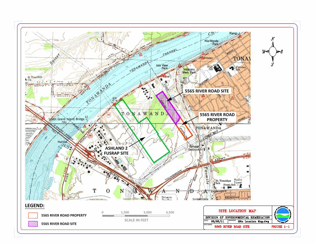
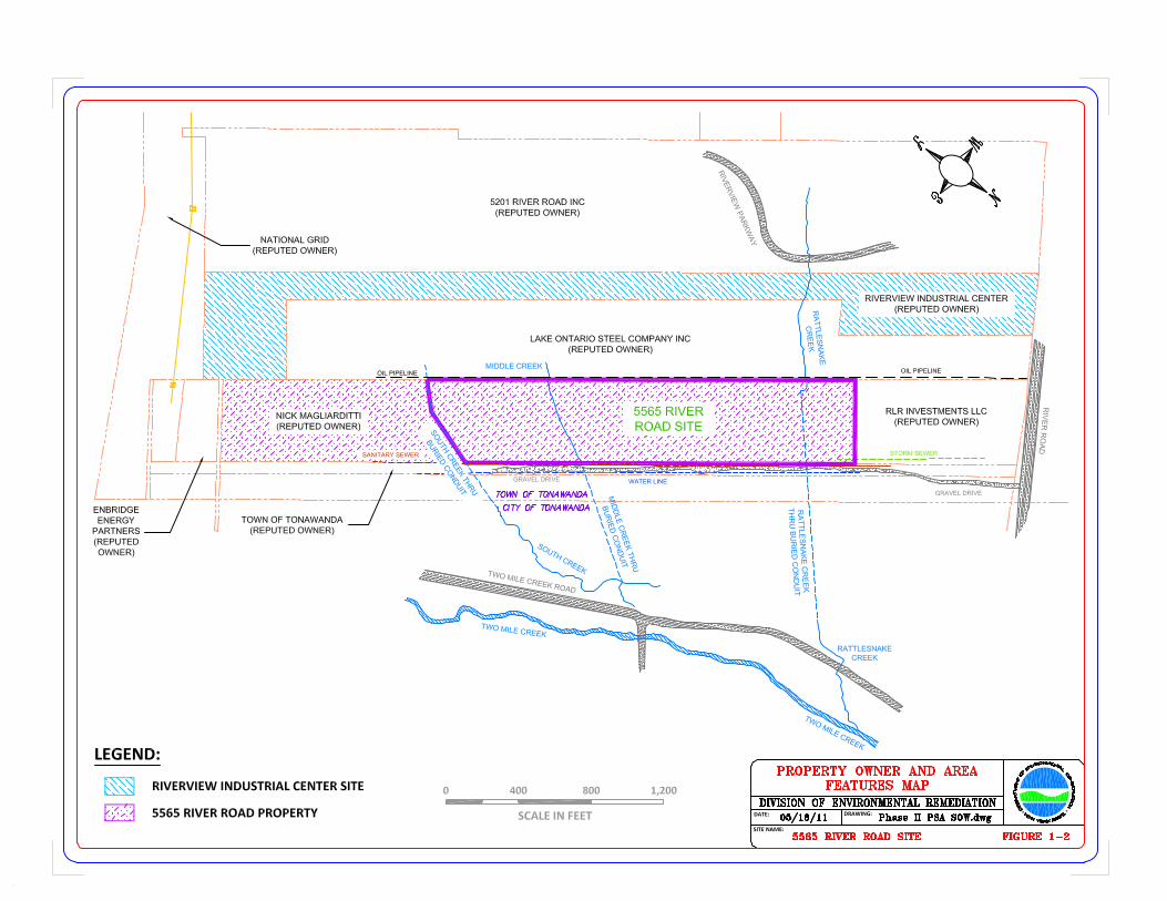
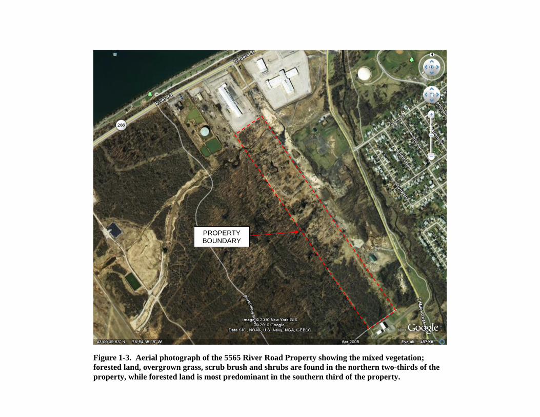
PROPERTY BOUNDARY
Figure 1-3. Aerial photograph of the 5565 River Road Property showing the mixed vegetation; forested land, overgrown grass, scrub brush and shrubs are found in the northern two-thirds of the property, while forested land is most predominant in the southern third of the property.
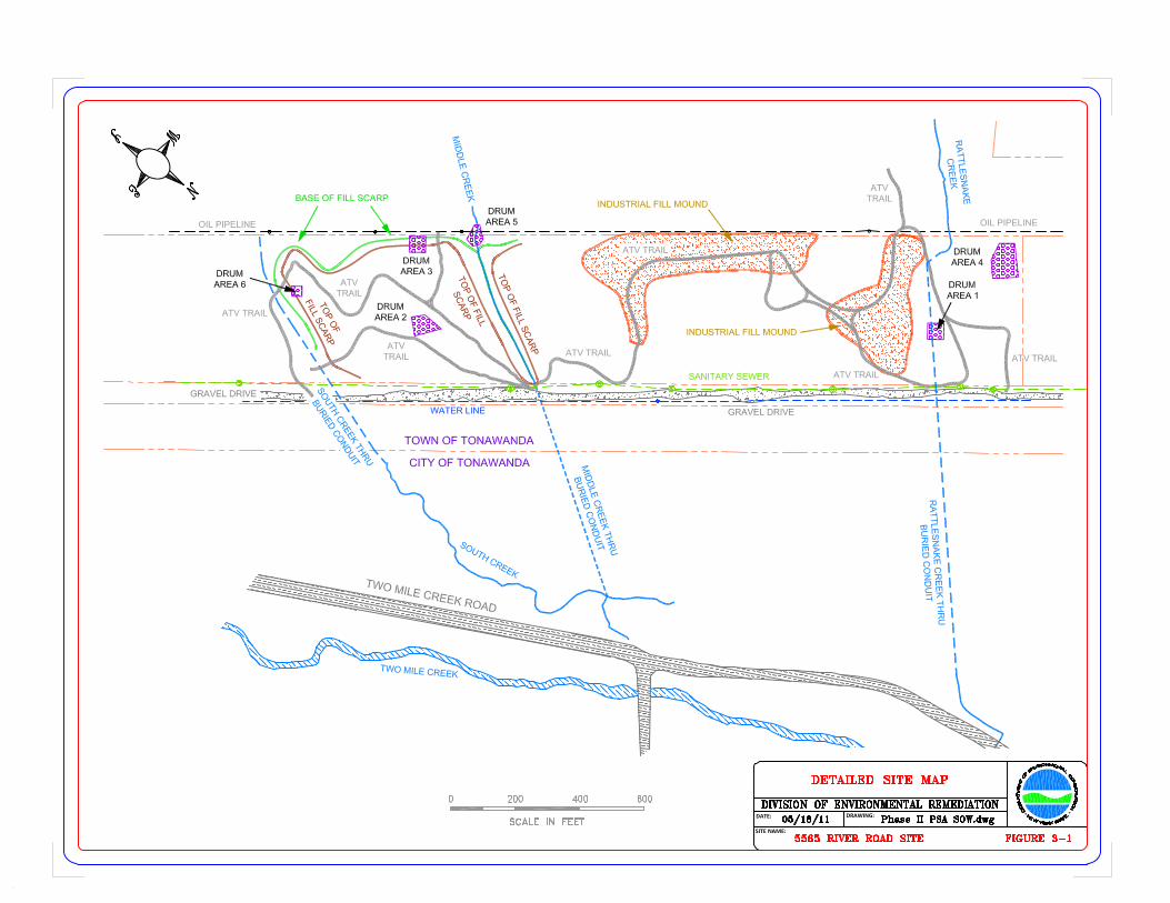
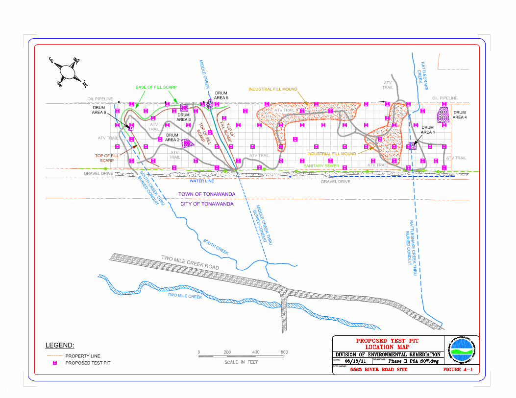
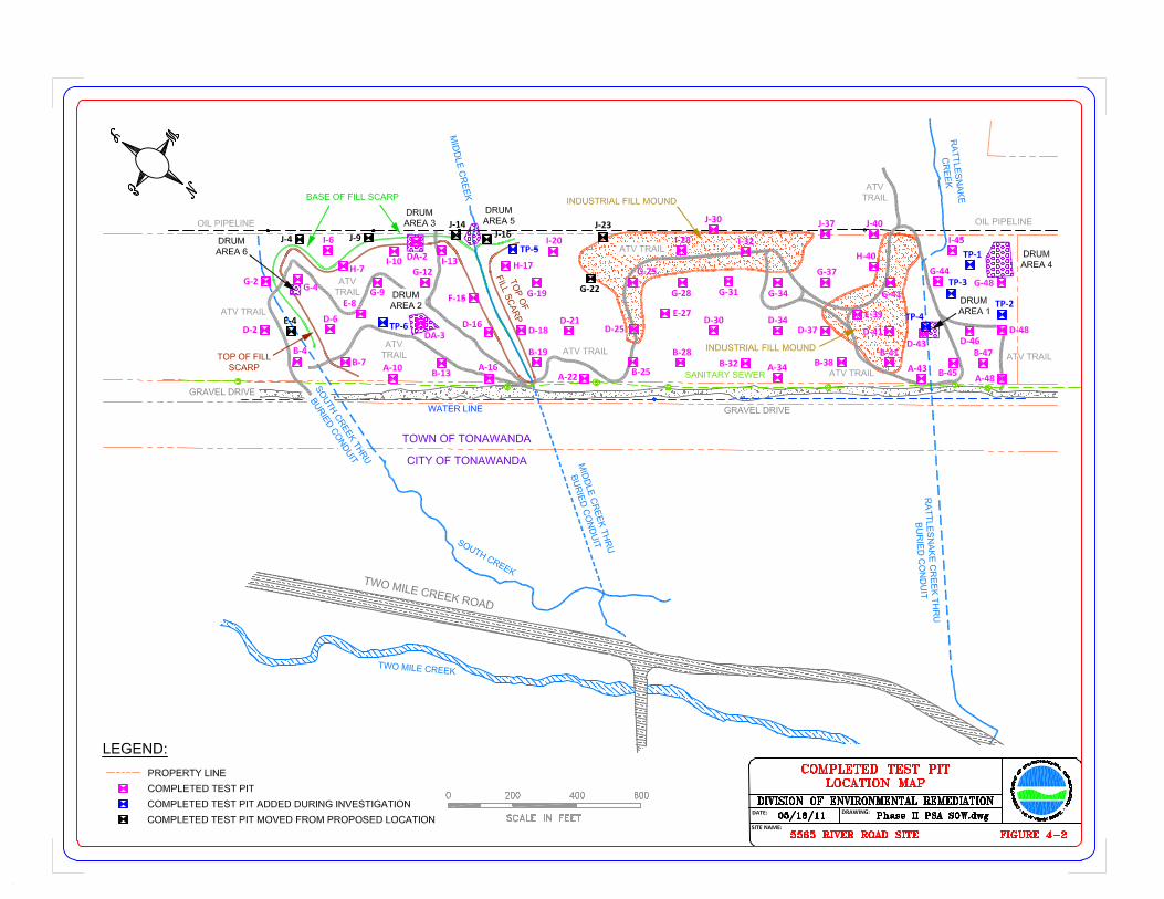
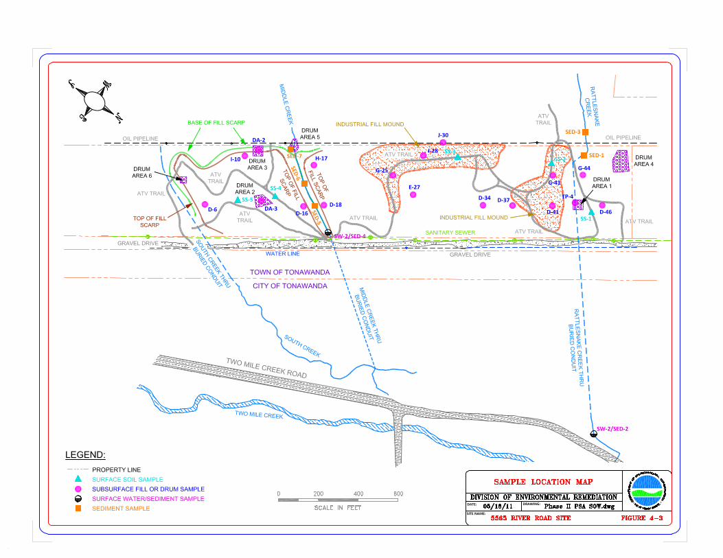
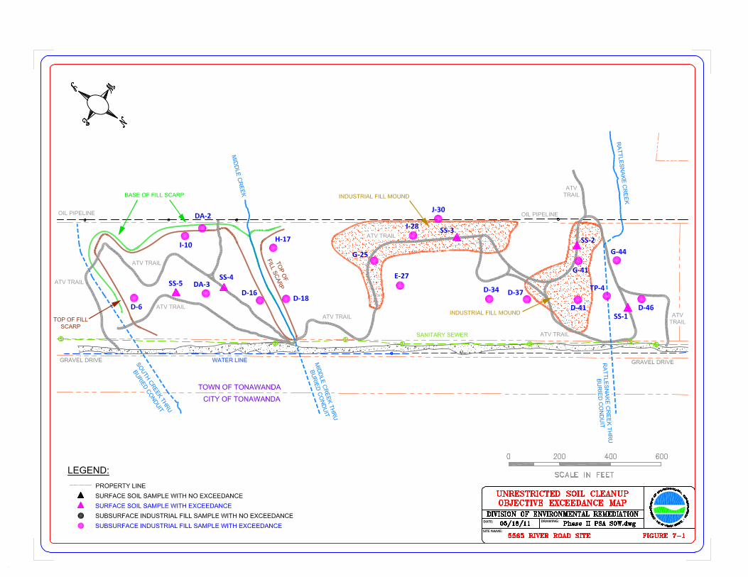
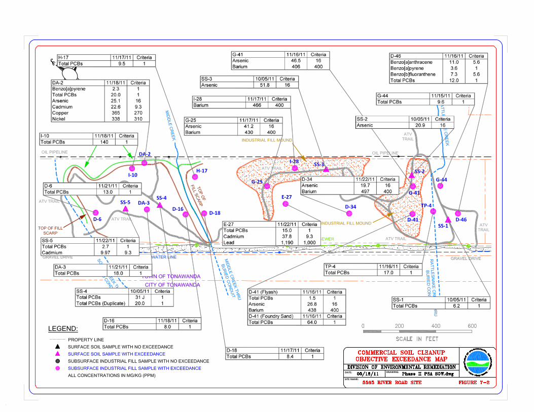

TABLES
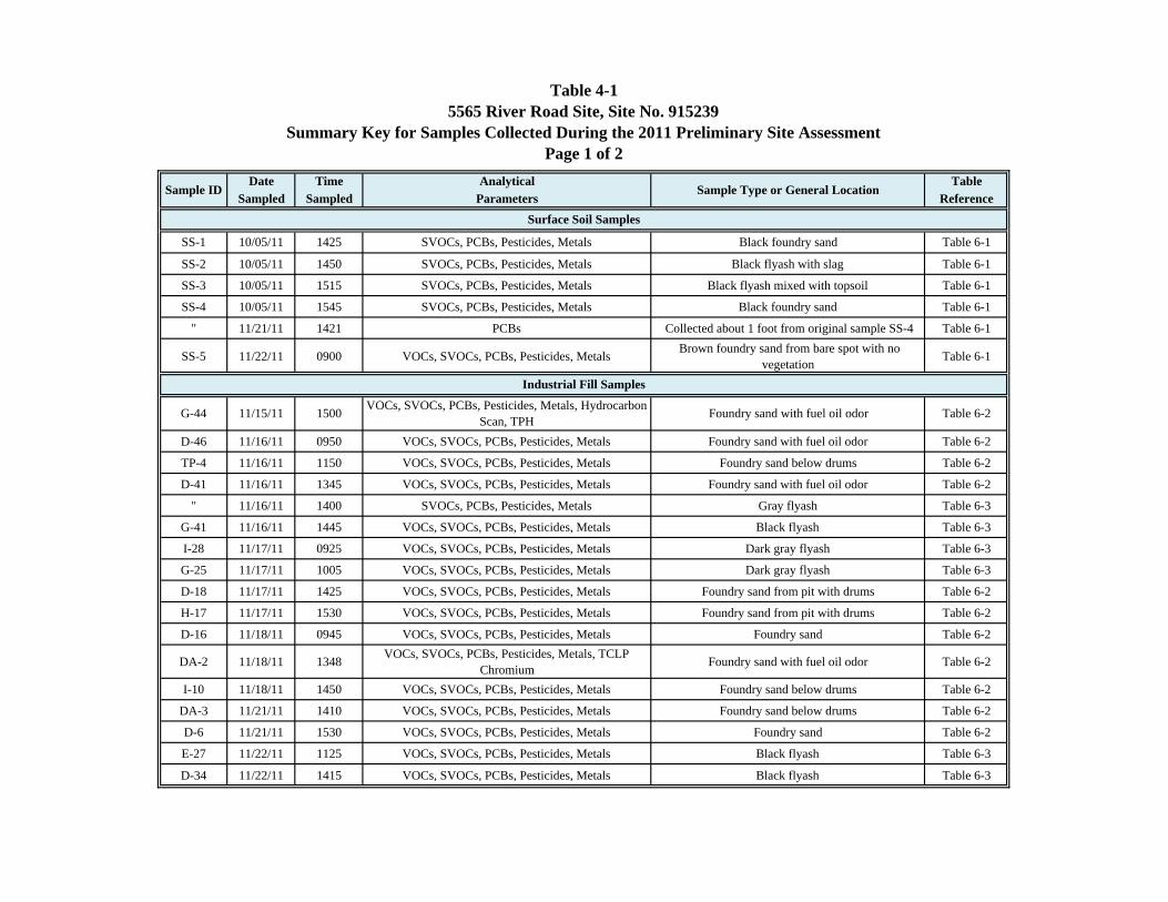
Table 4-15565 River Road Site, Site No. 915239
Summary Key for Samples Collected During the 2011 Preliminary Site AssessmentPage 1 of 2
Date Time Analytical TableSampled Sampled Parameters Reference
SS-1 10/05/11 1425 SVOCs, PCBs, Pesticides, Metals Black foundry sand Table 6-1
SS-2 10/05/11 1450 SVOCs, PCBs, Pesticides, Metals Black flyash with slag Table 6-1
SS-3 10/05/11 1515 SVOCs, PCBs, Pesticides, Metals Black flyash mixed with topsoil Table 6-1
SS-4 10/05/11 1545 SVOCs, PCBs, Pesticides, Metals Black foundry sand Table 6-1
" 11/21/11 1421 PCBs Collected about 1 foot from original sample SS-4 Table 6-1
SS-5 11/22/11 0900 VOCs, SVOCs, PCBs, Pesticides, Metals Brown foundry sand from bare spot with no vegetation Table 6-1
G-44 11/15/11 1500 VOCs, SVOCs, PCBs, Pesticides, Metals, Hydrocarbon Scan, TPH Foundry sand with fuel oil odor Table 6-2
D-46 11/16/11 0950 VOCs, SVOCs, PCBs, Pesticides, Metals Foundry sand with fuel oil odor Table 6-2
TP-4 11/16/11 1150 VOCs, SVOCs, PCBs, Pesticides, Metals Foundry sand below drums Table 6-2
D-41 11/16/11 1345 VOCs, SVOCs, PCBs, Pesticides, Metals Foundry sand with fuel oil odor Table 6-2
" 11/16/11 1400 SVOCs, PCBs, Pesticides, Metals Gray flyash Table 6-3
G-41 11/16/11 1445 VOCs, SVOCs, PCBs, Pesticides, Metals Black flyash Table 6-3
I-28 11/17/11 0925 VOCs, SVOCs, PCBs, Pesticides, Metals Dark gray flyash Table 6-3
G-25 11/17/11 1005 VOCs, SVOCs, PCBs, Pesticides, Metals Dark gray flyash Table 6-3
D-18 11/17/11 1425 VOCs, SVOCs, PCBs, Pesticides, Metals Foundry sand from pit with drums Table 6-2
H-17 11/17/11 1530 VOCs, SVOCs, PCBs, Pesticides, Metals Foundry sand from pit with drums Table 6-2
D-16 11/18/11 0945 VOCs, SVOCs, PCBs, Pesticides, Metals Foundry sand Table 6-2
DA-2 11/18/11 1348 VOCs, SVOCs, PCBs, Pesticides, Metals, TCLP Chromium Foundry sand with fuel oil odor Table 6-2
I-10 11/18/11 1450 VOCs, SVOCs, PCBs, Pesticides, Metals Foundry sand below drums Table 6-2
DA-3 11/21/11 1410 VOCs, SVOCs, PCBs, Pesticides, Metals Foundry sand below drums Table 6-2
D-6 11/21/11 1530 VOCs, SVOCs, PCBs, Pesticides, Metals Foundry sand Table 6-2
E-27 11/22/11 1125 VOCs, SVOCs, PCBs, Pesticides, Metals Black flyash Table 6-3
D-34 11/22/11 1415 VOCs, SVOCs, PCBs, Pesticides, Metals Black flyash Table 6-3
Industrial Fill Samples
Sample ID Sample Type or General Location
Surface Soil Samples
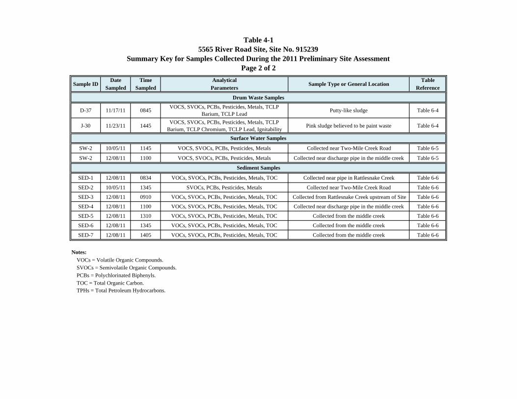
Table 4-15565 River Road Site, Site No. 915239
Summary Key for Samples Collected During the 2011 Preliminary Site AssessmentPage 2 of 2
Date Time Analytical TableSampled Sampled Parameters Reference
Sample ID Sample Type or General Location
D-37 11/17/11 0845 VOCS, SVOCs, PCBs, Pesticides, Metals, TCLP Barium, TCLP Lead Putty-like sludge Table 6-4
J-30 11/23/11 1445 VOCS, SVOCs, PCBs, Pesticides, Metals, TCLP Barium, TCLP Chromium, TCLP Lead, Ignitability Pink sludge believed to be paint waste Table 6-4
SW-2 10/05/11 1145 VOCS, SVOCs, PCBs, Pesticides, Metals Collected near Two-Mile Creek Road Table 6-5
SW-2 12/08/11 1100 VOCS, SVOCs, PCBs, Pesticides, Metals Collected near discharge pipe in the middle creek Table 6-5
SED-1 12/08/11 0834 VOCs, SVOCs, PCBs, Pesticides, Metals, TOC Collected near pipe in Rattlesnake Creek Table 6-6
SED-2 10/05/11 1345 SVOCs, PCBs, Pesticides, Metals Collected near Two-Mile Creek Road Table 6-6
SED-3 12/08/11 0910 VOCs, SVOCs, PCBs, Pesticides, Metals, TOC Collected from Rattlesnake Creek upstream of Site Table 6-6
SED-4 12/08/11 1100 VOCs, SVOCs, PCBs, Pesticides, Metals, TOC Collected near discharge pipe in the middle creek Table 6-6
SED-5 12/08/11 1310 VOCs, SVOCs, PCBs, Pesticides, Metals, TOC Collected from the middle creek Table 6-6
SED-6 12/08/11 1345 VOCs, SVOCs, PCBs, Pesticides, Metals, TOC Collected from the middle creek Table 6-6
SED-7 12/08/11 1405 VOCs, SVOCs, PCBs, Pesticides, Metals, TOC Collected from the middle creek Table 6-6
Notes:VOCs = Volatile Organic Compounds.SVOCs = Semivolatile Organic Compounds.PCBs = Polychlorinated Biphenyls.TOC = Total Organic Carbon.TPHs = Total Petroleum Hydrocarbons.
Surface Water Samples
Sediment Samples
Drum Waste Samples
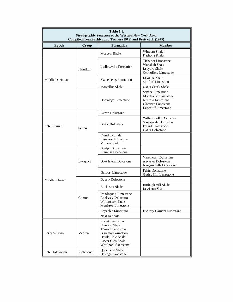
Table 5-1. Stratigraphic Sequence of the Western New York Area.
Compiled from Buehler and Tesmer (1963) and Brett et al. (1995).
Epoch Group Formation Member
Middle Devonian
Hamilton
Moscow Shale Windom Shale Kashong Shale
Ludlowville Formation
Tichenor Limestone Wanakah Shale Ledyard Shale Centerfield Limestone
Skaneateles Formation Levanna Shale Stafford Limestone
Marcellus Shale Oatka Creek Shale
Onondaga Limestone
Seneca Limestone Morehouse Limestone Nedrow Limestone Clarence Limestone Edgecliff Limestone
Late Silurian Salina
Akron Dolostone
Bertie Dolostone
Williamsville Dolostone Scajaquada Dolostone Falkirk Dolostone Oatka Dolostone
Camillus Shale Syracuse Formation Vernon Shale
Middle Silurian
Lockport
Guelph Dolostone Eramosa Dolostone
Goat Island Dolostone Vinemount Dolostone Ancaster Dolostone Niagara Falls Dolostone
Gasport Limestone Pekin Dolostone Gothic Hill Limestone
Clinton
Decew Dolostone
Rochester Shale Burleigh Hill Shale Lewiston Shale
Irondequoit Limestone Rockway Dolostone Williamson Shale Merritton Limestone
Reynales Limestone Hickory Corners Limestone Neahga Shale
Early Silurian Medina
Kodak Sandstone Cambria Shale Thorold Sandstone Grimsby Formation Devils Hole Shale Power Glen Shale Whirlpool Sandstone
Late Ordovician Richmond Queenston Shale Oswego Sandstone
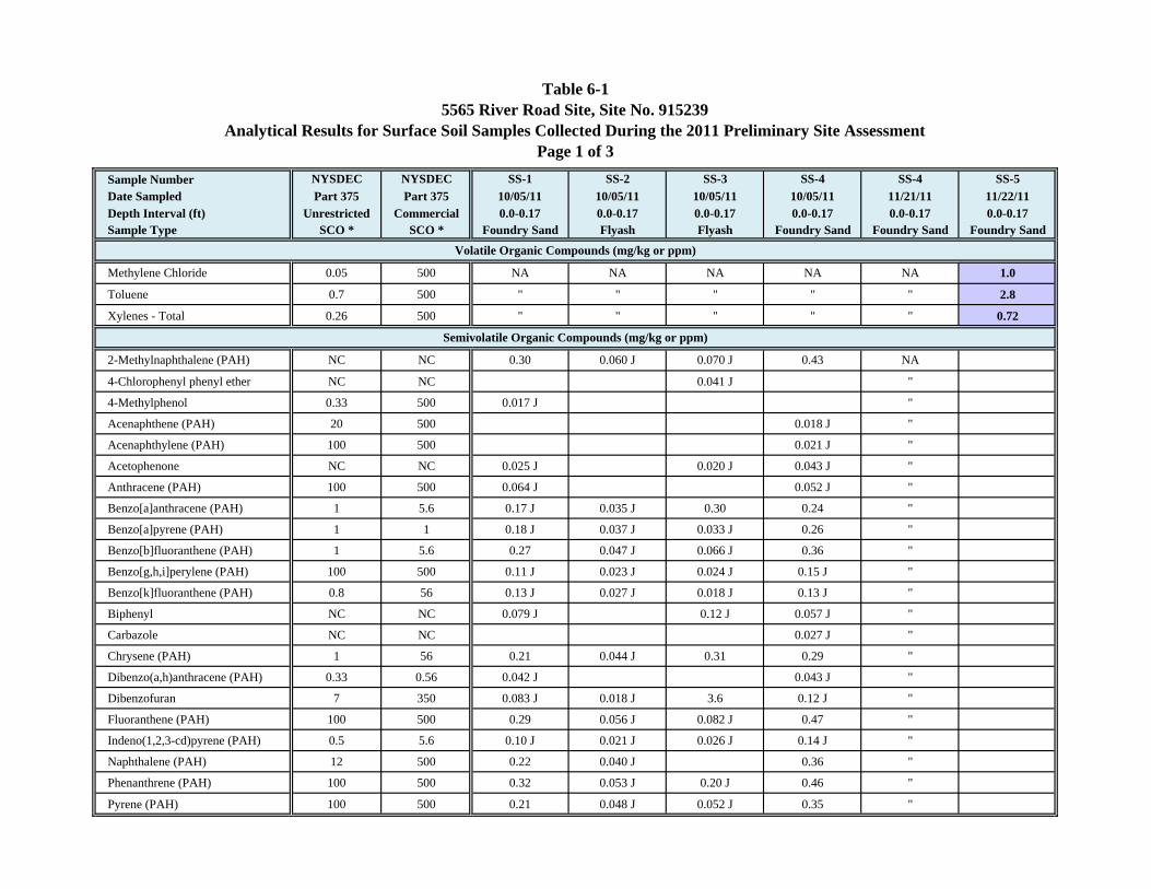
Table 6-15565 River Road Site, Site No. 915239
Analytical Results for Surface Soil Samples Collected During the 2011 Preliminary Site AssessmentPage 1 of 3
Sample Number NYSDEC NYSDEC SS-1 SS-2 SS-3 SS-4 SS-4 SS-5Date Sampled Part 375 Part 375 10/05/11 10/05/11 10/05/11 10/05/11 11/21/11 11/22/11Depth Interval (ft) Unrestricted Commercial 0.0-0.17 0.0-0.17 0.0-0.17 0.0-0.17 0.0-0.17 0.0-0.17Sample Type SCO * SCO * Foundry Sand Flyash Flyash Foundry Sand Foundry Sand Foundry Sand
Methylene Chloride 0.05 500 NA NA NA NA NA 1.0
Toluene 0.7 500 " " " " " 2.8
Xylenes - Total 0.26 500 " " " " " 0.72
2-Methylnaphthalene (PAH) NC NC 0.30 0.060 J 0.070 J 0.43 NA
4-Chlorophenyl phenyl ether NC NC 0.041 J "
4-Methylphenol 0.33 500 0.017 J "
Acenaphthene (PAH) 20 500 0.018 J "
Acenaphthylene (PAH) 100 500 0.021 J "
Acetophenone NC NC 0.025 J 0.020 J 0.043 J "
Anthracene (PAH) 100 500 0.064 J 0.052 J "
Benzo[a]anthracene (PAH) 1 5.6 0.17 J 0.035 J 0.30 0.24 "
Benzo[a]pyrene (PAH) 1 1 0.18 J 0.037 J 0.033 J 0.26 "
Benzo[b]fluoranthene (PAH) 1 5.6 0.27 0.047 J 0.066 J 0.36 "
Benzo[g,h,i]perylene (PAH) 100 500 0.11 J 0.023 J 0.024 J 0.15 J "
Benzo[k]fluoranthene (PAH) 0.8 56 0.13 J 0.027 J 0.018 J 0.13 J "
Biphenyl NC NC 0.079 J 0.12 J 0.057 J "
Carbazole NC NC 0.027 J "
Chrysene (PAH) 1 56 0.21 0.044 J 0.31 0.29 "
Dibenzo(a,h)anthracene (PAH) 0.33 0.56 0.042 J 0.043 J "
Dibenzofuran 7 350 0.083 J 0.018 J 3.6 0.12 J "
Fluoranthene (PAH) 100 500 0.29 0.056 J 0.082 J 0.47 "
Indeno(1,2,3-cd)pyrene (PAH) 0.5 5.6 0.10 J 0.021 J 0.026 J 0.14 J "
Naphthalene (PAH) 12 500 0.22 0.040 J 0.36 "
Phenanthrene (PAH) 100 500 0.32 0.053 J 0.20 J 0.46 "
Pyrene (PAH) 100 500 0.21 0.048 J 0.052 J 0.35 "
Volatile Organic Compounds (mg/kg or ppm)
Semivolatile Organic Compounds (mg/kg or ppm)
Table 6-15565 River Road Site, Site No. 915239
Analytical Results for Surface Soil Samples Collected During the 2011 Preliminary Site AssessmentPage 2 of 3
Sample Number NYSDEC NYSDEC SS-1 SS-2 SS-3 SS-4 SS-4 SS-5Date Sampled Part 375 Part 375 10/05/11 10/05/11 10/05/11 10/05/11 11/21/11 11/22/11Depth Interval (ft) Unrestricted Commercial 0.0-0.17 0.0-0.17 0.0-0.17 0.0-0.17 0.0-0.17 0.0-0.17Sample Type SCO * SCO * Foundry Sand Flyash Flyash Foundry Sand Foundry Sand Foundry Sand
4,4'-DDE 0.0033 62 0.0019 NA
beta-BHC 0.036 3 0.00083 J "
Endosulfan I 2.4 200 0.13 0.59 "
Endosulfan II 2.4 200 0.079 J "
Endrin 0.014 89 0.0068 J 0.13 J "
Endrin aldehyde NC NC 0.039 J "
Heptachlor 0.042 15 0.08 J 0.00065 J 0.0041 J 0.42 "
Aroclor 1248 6.2 0.14 J 29.0 20.0 2.7
Aroclor 1260 2 J
Total PCBs 0.1 1 6.2 0.14 J 31 J 20.0 2.7
Aluminum NC 10,000 ! 9,290 11,700 13,700 12,600 NA 4,520
Arsenic # 13 16 9.0 20.9 51.8 7.4 "
Barium 350 400 185 160 283 118 " 115
Beryllium # 7.2 590 0.84 0.89 2.6 0.86 "
Cadmium # 2.5 9.3 0.76 1.4 8.5 " 9.97
Chromium # 30 1,500 192 19.6 43.7 167 " 354
Cobalt NC 30 ** 7.3 3.1 7.9 6.7 " 9.09
Copper # 50 270 145 11.2 28.1 139 " 127
Iron NC 2,000 ** 66,000 26,800 36,400 69,400 " 83,400
Lead # 63 1,000 93.2 15.4 52.3 373 " 248
Manganese 1,600 10,000 2,340 81.3 214 2,090 " 908
Mercury # 0.18 2.8 0.057 0.099 0.26 0.064 "
Nickel # 30 310 71.2 9.4 22.4 55.8 " 105
Silver # 2 1,500 1.3 "
Metals (mg/kg or ppm)
Pesticides (mg/kg or ppm)
PCBs (mg/kg or ppm)
Table 6-15565 River Road Site, Site No. 915239
Analytical Results for Surface Soil Samples Collected During the 2011 Preliminary Site AssessmentPage 3 of 3
Sample Number NYSDEC NYSDEC SS-1 SS-2 SS-3 SS-4 SS-4 SS-5Date Sampled Part 375 Part 375 10/05/11 10/05/11 10/05/11 10/05/11 11/21/11 11/22/11Depth Interval (ft) Unrestricted Commercial 0.0-0.17 0.0-0.17 0.0-0.17 0.0-0.17 0.0-0.17 0.0-0.17Sample Type SCO * SCO * Foundry Sand Flyash Flyash Foundry Sand Foundry Sand Foundry Sand
Vanadium NC 100 ** 19.7 19.2 40.1 11.3 NA 19.7
Zinc # 109 10,000 203 26.9 153 1,040 " 132
Notes:* = 6 NYCRR Part 375: Environmental Remediation Programs, Unrestricted and Commercial Soil Cleanup Objectives, NYSDEC, 2006.** = Residential soil cleanup objective from Commissioner's Policy CP-51 entitled "Soil Cleanup Guidance", NYSDEC, 2010.! = Protection of ecological resources soil cleanup objective from Commissioner's Policy CP-51 entitled "Soil Cleanup Guidance", NYSDEC, 2010.# = Environmental Protection Agency priority pollutant metal.J = Analyte is positively identified with concentration qualified as estimated value.NA = Not analyzed.NC = No criteria.PAH = Polycyclic aromatic hydrocarbon.SCO = Soil cleanup objective.Blanks = compound not detected.Shaded = Result exceeds the 6 NYCRR Part 375 Unrestriced Use Objectives.Shaded = Result exceeds the 6 NYCRR Part 375 Commercial Use Objectives.Shaded = Result exceeds the Commissioner's Policy CP-51 Residential Use Objectives.Shaded = Result exceeds the Commissioner's Policy CP-51 Protection of Ecological Resources Objectives.
Table 6-2A5565 River Road Site, Site No. 915239
Analytical Results for Subsurface Foundry Sand Samples Collected During the 2011 Preliminary Site AssessmentPage 1 of 3
Sample Number NYSDEC NYSDEC G-44 D-46 TP-4 D-41 D-18 H-17Date Sampled Part 375 Part 375 11/15/11 11/16/11 11/16/11 11/16/11 11/17/11 11/17/11Depth Interval (ft) Unrestricted Commercial Composite Composite Composite Composite Composite CompositeSample Type SCO * SCO * Foundry Sand Foundry Sand Foundry Sand Foundry Sand Foundry Sand Foundry Sand
1,2,4-Trimethylbenzene 3.6 190 0.16
1,3,5-Trimethylbenzene 8.4 190 0.073
Acetone 0.05 500 0.46
Carbon Disulfide NC 100 ** 0.019
Methylcyclohexane NC NC 0.21
Methylene Chloride 0.05 500 0.006 B 0.0072 B 0.70 B 0.0072 B
n-Propylbenzene 3.9 500 0.045
Toluene 0.7 500 0.47 J 0.0069 J
Trichloroethene 0.47 200 0.027
Xylenes - Total 0.26 500 0.095
2,4-Dimethylphenol NC NC 0.99 J 0.042 J
2-Methylnaphthalene (PAH) NC NC 3.1 3.0 J 0.27 1.8 J 0.22 0.46
Acenaphthene (PAH) 20 500 7.2 8.1 0.93 J 0.086 J
Anthracene (PAH) 100 500 0.30 10.0
Benzo[a]anthracene (PAH) 1 5.6 0.44 11.0 0.10 J 0.64 J 0.12 J 0.14 J
Benzo[a]pyrene (PAH) 1 1 0.41 3.6 0.099 J 0.13 J 0.12 J
Benzo[b]fluoranthene (PAH) 1 5.6 0.77 7.3 0.27 0.23 0.25
Benzo[g,h,i]perylene (PAH) 100 500 0.15 J
Benzo[k]fluoranthene (PAH) 0.8 56 0.27 2.7 J
Biphenyl NC NC 2.0 0.04 J 0.06 J 0.11 J
Bis(2-ethylhexyl)phthalate NC 50 ** 0.75 B 12.0 0.22 B 1.9 J 0.26 B 0.32 B
Caprolactam NC NC 0.063 J
Carbazole NC NC 1.6 J 0.11 J
Chrysene (PAH) 1 56 0.48 8.9 0.15 J 0.64 J 0.14 J 0.16 J
Dibenzofuran 7 350 6.5 0.069 J 0.051 J 0.11 J
Semivolatile Organic Compounds (mg/kg or ppm)
Volatile Organic Compounds (mg/kg or ppm)
Table 6-2A5565 River Road Site, Site No. 915239
Analytical Results for Subsurface Foundry Sand Samples Collected During the 2011 Preliminary Site AssessmentPage 2 of 3
Sample Number NYSDEC NYSDEC G-44 D-46 TP-4 D-41 D-18 H-17Date Sampled Part 375 Part 375 11/15/11 11/16/11 11/16/11 11/16/11 11/17/11 11/17/11Depth Interval (ft) Unrestricted Commercial Composite Composite Composite Composite Composite CompositeSample Type SCO * SCO * Foundry Sand Foundry Sand Foundry Sand Foundry Sand Foundry Sand Foundry Sand
Di-n-butylphthalate NC 100 ** 0.097 J 0.079 J
Fluorene (PAH) 30 500 2.1 12.0 1.4 J
Fluoranthene (PAH) 100 500 0.77 46.0 0.16 J 2.1 J 0.23 0.19 J
Indeno(1,2,3-cd)pyrene (PAH) 0.5 5.6 0.18 J 0.064 J
Naphthalene (PAH) 12 500 1.0 9.3 0.22 1.6 J 0.14 J 1.6
Phenanthrene (PAH) 100 500 1.9 18.0 0.20 1.8 J 0.25 0.37
Pyrene (PAH) 100 500 1.3 30.0 0.20 1.8 J 0.26 0.20
None Detected NA NA
Aroclor 1248 9.6 12.0 17.0 64.0 8.4 9.5
Aroclor 1260
Total PCBs 0.1 1 9.6 12.0 17.0 64.0 8.4 9.5
Aluminum NC 10,000 ! 5,890 9,370 6,580 7,230 4,950 4,070
Barium 350 400 102 121 198 107 83.2 63.8
Cadmium # 2.5 9.3 4.01 5.10 1.34 9.29 1.92 1.87
Chromium # 30 1,500 142 188 27.9 230 65.6 65.0
Cobalt NC 30 ** 8.61 6.32
Copper # 50 270 181 103 29.2 121 55.5 54.9
Iron NC 2,000 ** 48,000 51,700 11,400 56,800 17,900 22,000
Lead # 63 1,000 52.1 78.1 92.4 195 60.6 14.2
Manganese 1,600 10,000 1,470 1,590 1,910 2,310 1,660 1,050
Mercury # 0.18 2.8 0.231 0.206 0.410
Nickel # 30 310 59.3 67.9 12.2 59.1 18.2 23.7
Pesticides (mg/kg or ppm)
PCBs (mg/kg or ppm)
Metals (mg/kg or ppm)
Semivolatile Organic Compounds (Continued)
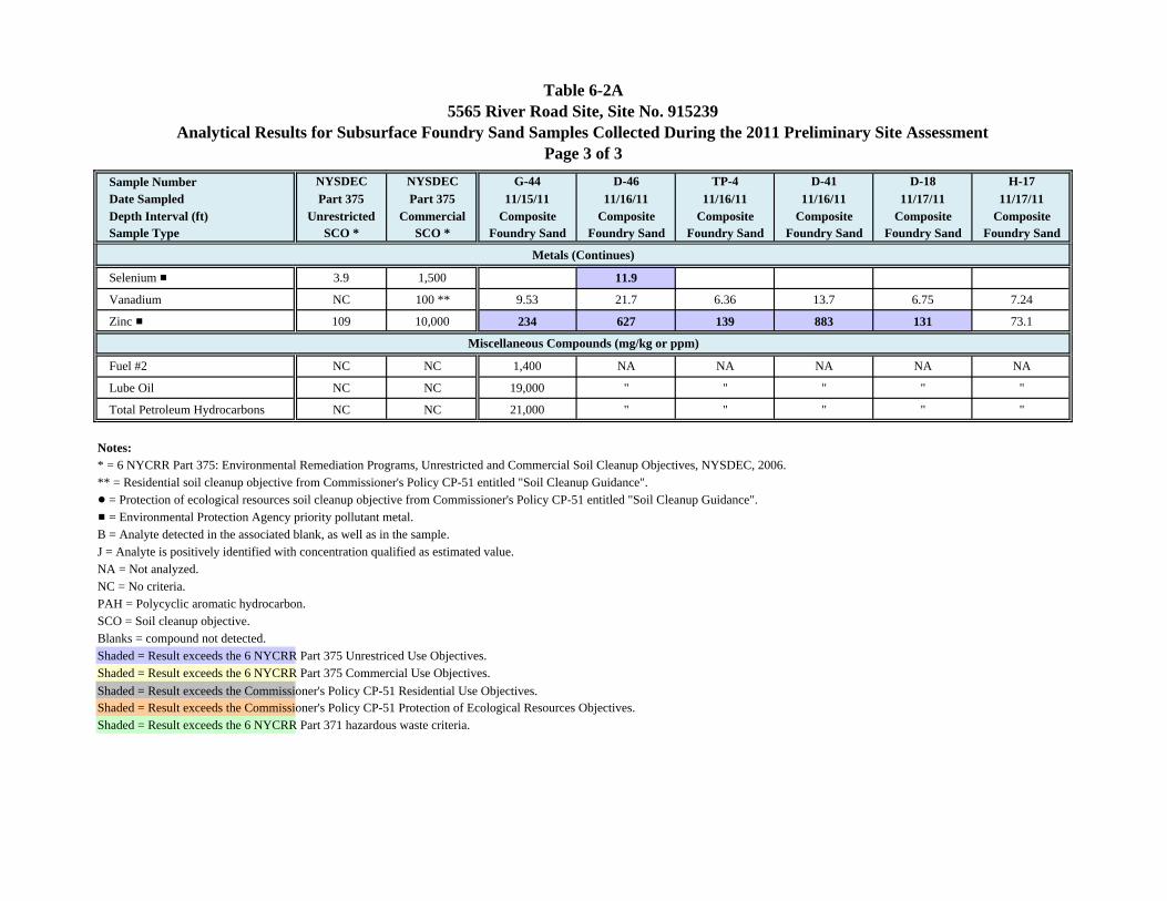
Table 6-2A5565 River Road Site, Site No. 915239
Analytical Results for Subsurface Foundry Sand Samples Collected During the 2011 Preliminary Site AssessmentPage 3 of 3
Sample Number NYSDEC NYSDEC G-44 D-46 TP-4 D-41 D-18 H-17Date Sampled Part 375 Part 375 11/15/11 11/16/11 11/16/11 11/16/11 11/17/11 11/17/11Depth Interval (ft) Unrestricted Commercial Composite Composite Composite Composite Composite CompositeSample Type SCO * SCO * Foundry Sand Foundry Sand Foundry Sand Foundry Sand Foundry Sand Foundry Sand
Selenium # 3.9 1,500 11.9
Vanadium NC 100 ** 9.53 21.7 6.36 13.7 6.75 7.24
Zinc # 109 10,000 234 627 139 883 131 73.1
Fuel #2 NC NC 1,400 NA NA NA NA NA
Lube Oil NC NC 19,000 " " " " "
Total Petroleum Hydrocarbons NC NC 21,000 " " " " "
Notes:* = 6 NYCRR Part 375: Environmental Remediation Programs, Unrestricted and Commercial Soil Cleanup Objectives, NYSDEC, 2006.** = Residential soil cleanup objective from Commissioner's Policy CP-51 entitled "Soil Cleanup Guidance".! = Protection of ecological resources soil cleanup objective from Commissioner's Policy CP-51 entitled "Soil Cleanup Guidance".# = Environmental Protection Agency priority pollutant metal.B = Analyte detected in the associated blank, as well as in the sample.J = Analyte is positively identified with concentration qualified as estimated value.NA = Not analyzed.NC = No criteria.PAH = Polycyclic aromatic hydrocarbon.SCO = Soil cleanup objective.Blanks = compound not detected.Shaded = Result exceeds the 6 NYCRR Part 375 Unrestriced Use Objectives.Shaded = Result exceeds the 6 NYCRR Part 375 Commercial Use Objectives.Shaded = Result exceeds the Commissioner's Policy CP-51 Residential Use Objectives.Shaded = Result exceeds the Commissioner's Policy CP-51 Protection of Ecological Resources Objectives.Shaded = Result exceeds the 6 NYCRR Part 371 hazardous waste criteria.
Miscellaneous Compounds (mg/kg or ppm)
Metals (Continues)
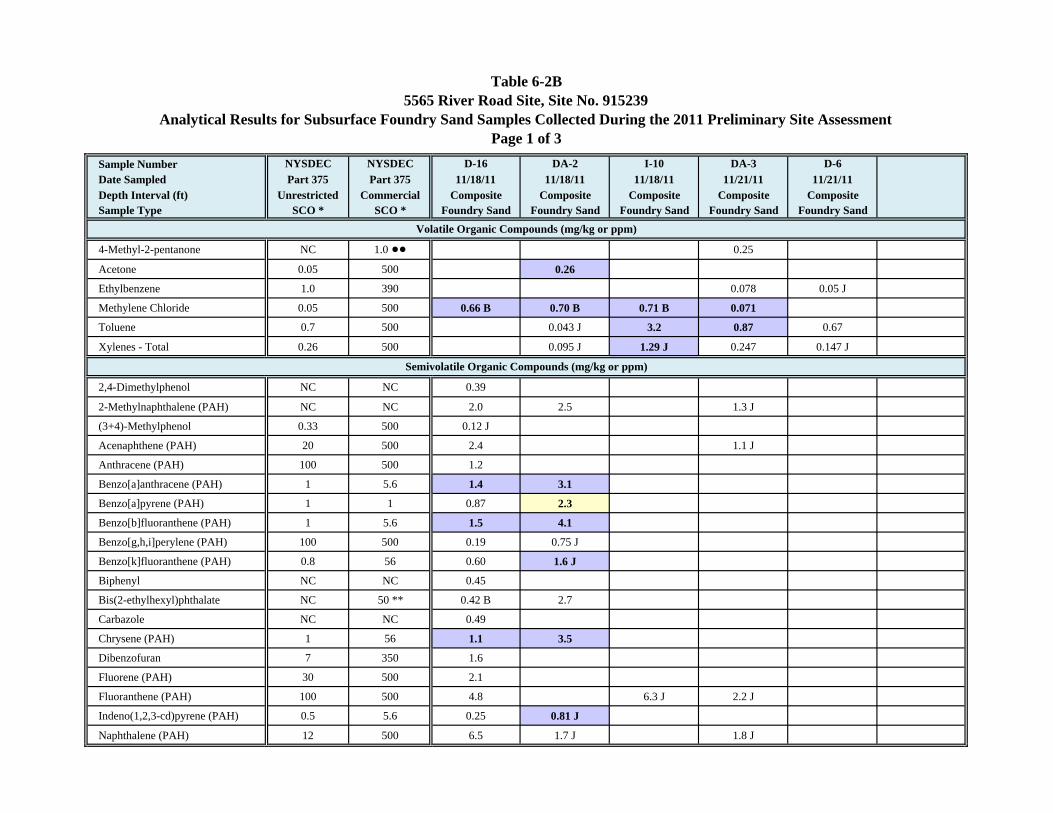
Table 6-2B5565 River Road Site, Site No. 915239
Analytical Results for Subsurface Foundry Sand Samples Collected During the 2011 Preliminary Site AssessmentPage 1 of 3
Sample Number NYSDEC NYSDEC D-16 DA-2 I-10 DA-3 D-6Date Sampled Part 375 Part 375 11/18/11 11/18/11 11/18/11 11/21/11 11/21/11Depth Interval (ft) Unrestricted Commercial Composite Composite Composite Composite CompositeSample Type SCO * SCO * Foundry Sand Foundry Sand Foundry Sand Foundry Sand Foundry Sand
4-Methyl-2-pentanone NC 1.0 !! 0.25
Acetone 0.05 500 0.26
Ethylbenzene 1.0 390 0.078 0.05 J
Methylene Chloride 0.05 500 0.66 B 0.70 B 0.71 B 0.071
Toluene 0.7 500 0.043 J 3.2 0.87 0.67
Xylenes - Total 0.26 500 0.095 J 1.29 J 0.247 0.147 J
2,4-Dimethylphenol NC NC 0.39
2-Methylnaphthalene (PAH) NC NC 2.0 2.5 1.3 J
(3+4)-Methylphenol 0.33 500 0.12 J
Acenaphthene (PAH) 20 500 2.4 1.1 J
Anthracene (PAH) 100 500 1.2
Benzo[a]anthracene (PAH) 1 5.6 1.4 3.1
Benzo[a]pyrene (PAH) 1 1 0.87 2.3
Benzo[b]fluoranthene (PAH) 1 5.6 1.5 4.1
Benzo[g,h,i]perylene (PAH) 100 500 0.19 0.75 J
Benzo[k]fluoranthene (PAH) 0.8 56 0.60 1.6 J
Biphenyl NC NC 0.45
Bis(2-ethylhexyl)phthalate NC 50 ** 0.42 B 2.7
Carbazole NC NC 0.49
Chrysene (PAH) 1 56 1.1 3.5
Dibenzofuran 7 350 1.6
Fluorene (PAH) 30 500 2.1
Fluoranthene (PAH) 100 500 4.8 6.3 J 2.2 J
Indeno(1,2,3-cd)pyrene (PAH) 0.5 5.6 0.25 0.81 J
Naphthalene (PAH) 12 500 6.5 1.7 J 1.8 J
Volatile Organic Compounds (mg/kg or ppm)
Semivolatile Organic Compounds (mg/kg or ppm)
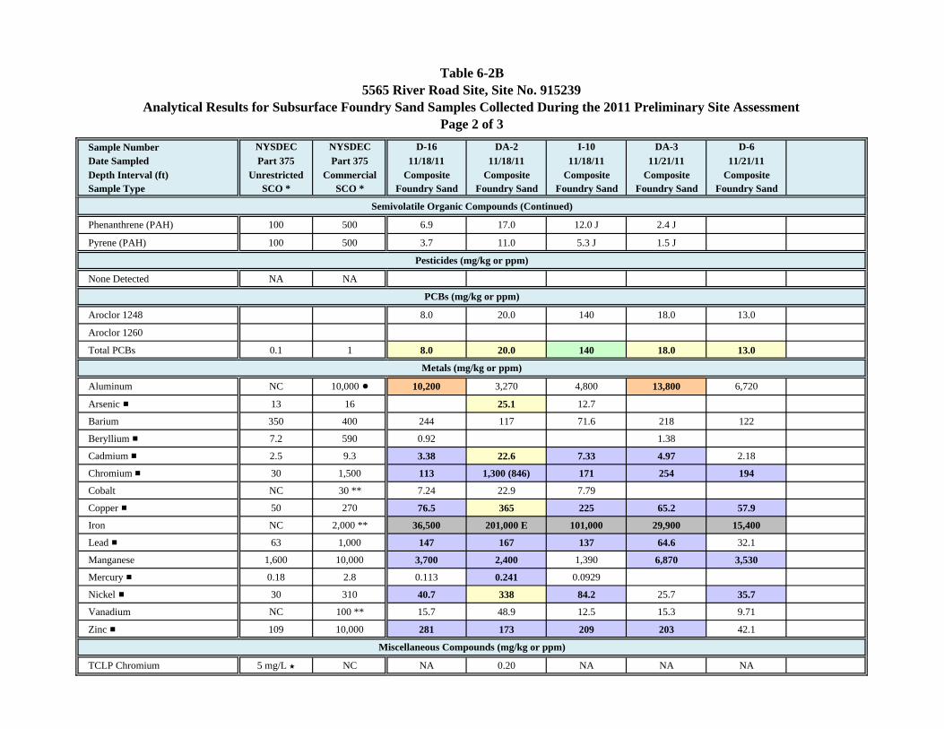
Table 6-2B5565 River Road Site, Site No. 915239
Analytical Results for Subsurface Foundry Sand Samples Collected During the 2011 Preliminary Site AssessmentPage 2 of 3
Sample Number NYSDEC NYSDEC D-16 DA-2 I-10 DA-3 D-6Date Sampled Part 375 Part 375 11/18/11 11/18/11 11/18/11 11/21/11 11/21/11Depth Interval (ft) Unrestricted Commercial Composite Composite Composite Composite CompositeSample Type SCO * SCO * Foundry Sand Foundry Sand Foundry Sand Foundry Sand Foundry Sand
Phenanthrene (PAH) 100 500 6.9 17.0 12.0 J 2.4 J
Pyrene (PAH) 100 500 3.7 11.0 5.3 J 1.5 J
None Detected NA NA
Aroclor 1248 8.0 20.0 140 18.0 13.0
Aroclor 1260
Total PCBs 0.1 1 8.0 20.0 140 18.0 13.0
Aluminum NC 10,000 ! 10,200 3,270 4,800 13,800 6,720
Arsenic # 13 16 25.1 12.7
Barium 350 400 244 117 71.6 218 122
Beryllium # 7.2 590 0.92 1.38
Cadmium # 2.5 9.3 3.38 22.6 7.33 4.97 2.18
Chromium # 30 1,500 113 1,300 (846) 171 254 194
Cobalt NC 30 ** 7.24 22.9 7.79
Copper # 50 270 76.5 365 225 65.2 57.9
Iron NC 2,000 ** 36,500 201,000 E 101,000 29,900 15,400
Lead # 63 1,000 147 167 137 64.6 32.1
Manganese 1,600 10,000 3,700 2,400 1,390 6,870 3,530
Mercury # 0.18 2.8 0.113 0.241 0.0929
Nickel # 30 310 40.7 338 84.2 25.7 35.7
Vanadium NC 100 ** 15.7 48.9 12.5 15.3 9.71
Zinc # 109 10,000 281 173 209 203 42.1
TCLP Chromium 5 mg/L ’ NC NA 0.20 NA NA NA
Miscellaneous Compounds (mg/kg or ppm)
Pesticides (mg/kg or ppm)
PCBs (mg/kg or ppm)
Metals (mg/kg or ppm)
Semivolatile Organic Compounds (Continued)
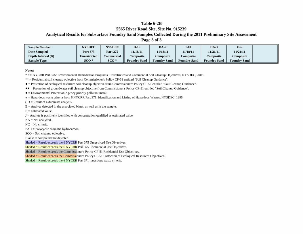
Table 6-2B5565 River Road Site, Site No. 915239
Analytical Results for Subsurface Foundry Sand Samples Collected During the 2011 Preliminary Site AssessmentPage 3 of 3
Sample Number NYSDEC NYSDEC D-16 DA-2 I-10 DA-3 D-6Date Sampled Part 375 Part 375 11/18/11 11/18/11 11/18/11 11/21/11 11/21/11Depth Interval (ft) Unrestricted Commercial Composite Composite Composite Composite CompositeSample Type SCO * SCO * Foundry Sand Foundry Sand Foundry Sand Foundry Sand Foundry Sand
Notes:* = 6 NYCRR Part 375: Environmental Remediation Programs, Unrestricted and Commercial Soil Cleanup Objectives, NYSDEC, 2006.** = Residential soil cleanup objective from Commissioner's Policy CP-51 entitled "Soil Cleanup Guidance".! = Protection of ecological resources soil cleanup objective from Commissioner's Policy CP-51 entitled "Soil Cleanup Guidance".!! = Protection of groundwater soil cleanup objective from Commissioner's Policy CP-51 entitled "Soil Cleanup Guidance".# = Environmental Protection Agency priority pollutant metal.’ = Hazardous waste criteria from 6 NYCRR Part 371: Identification and Listing of Hazardous Wastes, NYSDEC, 1995.( ) = Result of a duplicate analysis.B = Analyte detected in the associated blank, as well as in the sample.E = Estimated value.J = Analyte is positively identified with concentration qualified as estimated value.NA = Not analyzed.NC = No criteria.PAH = Polycyclic aromatic hydrocarbon.SCO = Soil cleanup objective.Blanks = compound not detected.Shaded = Result exceeds the 6 NYCRR Part 375 Unrestriced Use Objectives.Shaded = Result exceeds the 6 NYCRR Part 375 Commercial Use Objectives.Shaded = Result exceeds the Commissioner's Policy CP-51 Residential Use Objectives.Shaded = Result exceeds the Commissioner's Policy CP-51 Protection of Ecological Resources Objectives.Shaded = Result exceeds the 6 NYCRR Part 371 hazardous waste criteria.
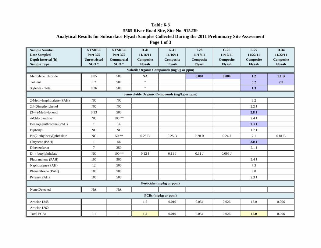
Table 6-35565 River Road Site, Site No. 915239
Analytical Results for Subsurface Flyash Samples Collected During the 2011 Preliminary Site AssessmentPage 1 of 3
Sample Number NYSDEC NYSDEC D-41 G-41 I-28 G-25 E-27 D-34Date Sampled Part 375 Part 375 11/16/11 11/16/11 11/17/11 11/17/11 11/22/11 11/22/11Depth Interval (ft) Unrestricted Commercial Composite Composite Composite Composite Composite CompositeSample Type SCO * SCO * Flyash Flyash Flyash Flyash Flyash Flyash
Methylene Chloride 0.05 500 NA 0.084 0.084 1.2 1.1 B
Toluene 0.7 500 " 5.2 2.9
Xylenes - Total 0.26 500 " 1.3
2-Methylnaphthalene (PAH) NC NC 8.2
2,4-Dimethylphenol NC NC 2.2 J
(3+4)-Methylphenol 0.33 500 2.8 J
4-Chloroaniline NC 100 ** 2.4 J
Benzo[a]anthracene (PAH) 1 5.6 1.3 J
Biphenyl NC NC 1.7 J
Bis(2-ethylhexyl)phthalate NC 50 ** 0.25 B 0.25 B 0.28 B 0.24 J 7.1 0.81 B
Chrysene (PAH) 1 56 2.0 J
Dibenzofuran 7 350 2.1 J
Di-n-butylphthalate NC 100 ** 0.12 J 0.11 J 0.11 J 0.096 J
Fluoranthene (PAH) 100 500 2.4 J
Naphthalene (PAH) 12 500 7.3
Phenanthrene (PAH) 100 500 8.0
Pyrene (PAH) 100 500 2.3 J
None Detected NA NA
Aroclor 1248 1.5 0.019 0.054 0.026 15.0 0.096
Aroclor 1260
Total PCBs 0.1 1 1.5 0.019 0.054 0.026 15.0 0.096
PCBs (mg/kg or ppm)
Volatile Organic Compounds (mg/kg or ppm)
Semivolatile Organic Compounds (mg/kg or ppm)
Pesticides (mg/kg or ppm)
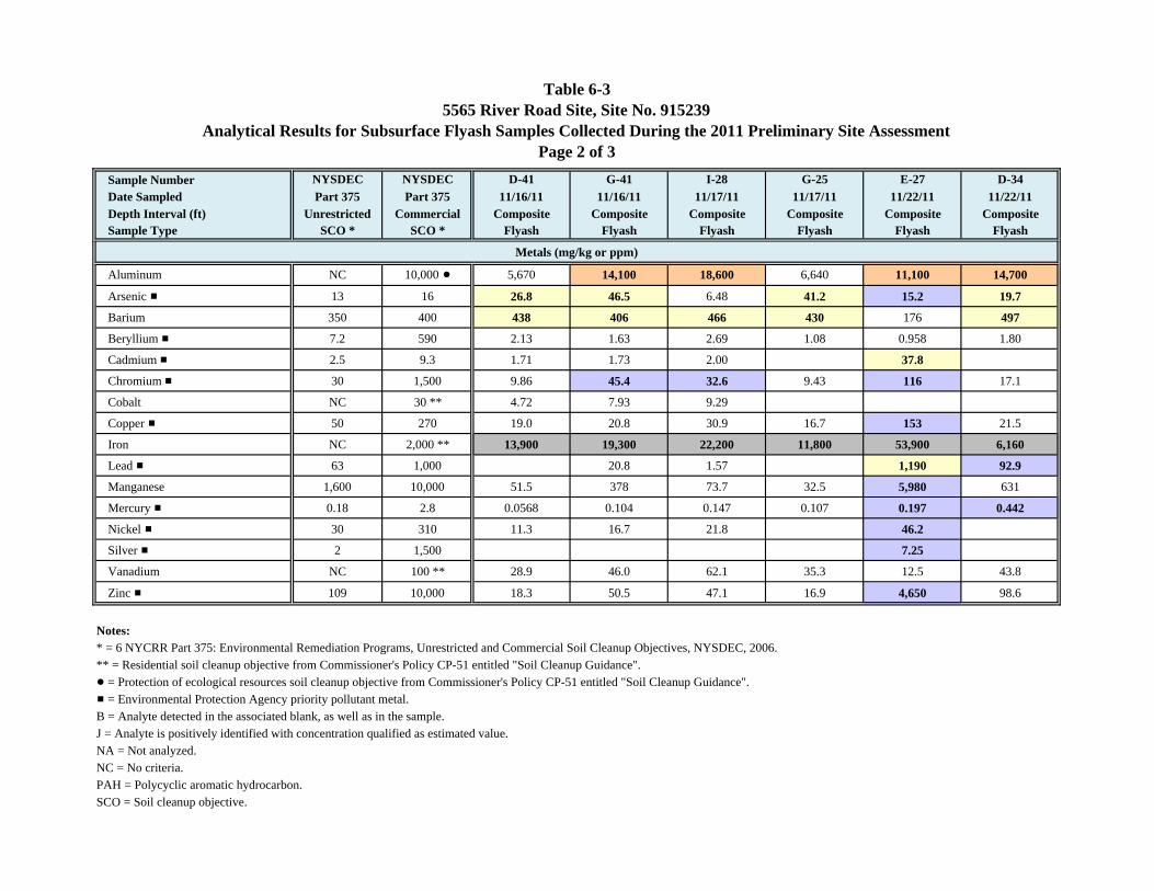
Table 6-35565 River Road Site, Site No. 915239
Analytical Results for Subsurface Flyash Samples Collected During the 2011 Preliminary Site AssessmentPage 2 of 3
Sample Number NYSDEC NYSDEC D-41 G-41 I-28 G-25 E-27 D-34Date Sampled Part 375 Part 375 11/16/11 11/16/11 11/17/11 11/17/11 11/22/11 11/22/11Depth Interval (ft) Unrestricted Commercial Composite Composite Composite Composite Composite CompositeSample Type SCO * SCO * Flyash Flyash Flyash Flyash Flyash Flyash
Aluminum NC 10,000 ! 5,670 14,100 18,600 6,640 11,100 14,700
Arsenic # 13 16 26.8 46.5 6.48 41.2 15.2 19.7
Barium 350 400 438 406 466 430 176 497
Beryllium # 7.2 590 2.13 1.63 2.69 1.08 0.958 1.80
Cadmium # 2.5 9.3 1.71 1.73 2.00 37.8
Chromium # 30 1,500 9.86 45.4 32.6 9.43 116 17.1
Cobalt NC 30 ** 4.72 7.93 9.29
Copper # 50 270 19.0 20.8 30.9 16.7 153 21.5
Iron NC 2,000 ** 13,900 19,300 22,200 11,800 53,900 6,160
Lead # 63 1,000 20.8 1.57 1,190 92.9
Manganese 1,600 10,000 51.5 378 73.7 32.5 5,980 631
Mercury # 0.18 2.8 0.0568 0.104 0.147 0.107 0.197 0.442
Nickel # 30 310 11.3 16.7 21.8 46.2
Silver # 2 1,500 7.25
Vanadium NC 100 ** 28.9 46.0 62.1 35.3 12.5 43.8
Zinc # 109 10,000 18.3 50.5 47.1 16.9 4,650 98.6
Notes:* = 6 NYCRR Part 375: Environmental Remediation Programs, Unrestricted and Commercial Soil Cleanup Objectives, NYSDEC, 2006.** = Residential soil cleanup objective from Commissioner's Policy CP-51 entitled "Soil Cleanup Guidance".! = Protection of ecological resources soil cleanup objective from Commissioner's Policy CP-51 entitled "Soil Cleanup Guidance".# = Environmental Protection Agency priority pollutant metal.B = Analyte detected in the associated blank, as well as in the sample.J = Analyte is positively identified with concentration qualified as estimated value.NA = Not analyzed.NC = No criteria.PAH = Polycyclic aromatic hydrocarbon.SCO = Soil cleanup objective.
Metals (mg/kg or ppm)
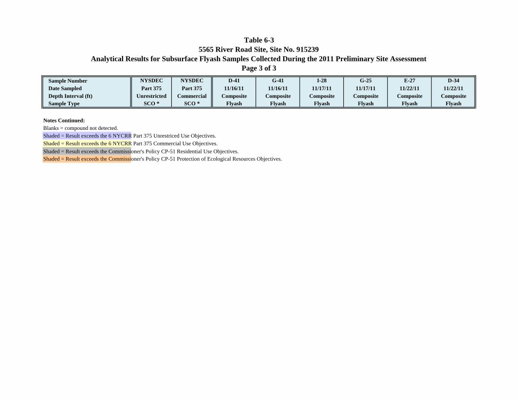
Table 6-35565 River Road Site, Site No. 915239
Analytical Results for Subsurface Flyash Samples Collected During the 2011 Preliminary Site AssessmentPage 3 of 3
Sample Number NYSDEC NYSDEC D-41 G-41 I-28 G-25 E-27 D-34Date Sampled Part 375 Part 375 11/16/11 11/16/11 11/17/11 11/17/11 11/22/11 11/22/11Depth Interval (ft) Unrestricted Commercial Composite Composite Composite Composite Composite CompositeSample Type SCO * SCO * Flyash Flyash Flyash Flyash Flyash Flyash
Notes Continued:Blanks = compound not detected.Shaded = Result exceeds the 6 NYCRR Part 375 Unrestriced Use Objectives.Shaded = Result exceeds the 6 NYCRR Part 375 Commercial Use Objectives.Shaded = Result exceeds the Commissioner's Policy CP-51 Residential Use Objectives.Shaded = Result exceeds the Commissioner's Policy CP-51 Protection of Ecological Resources Objectives.
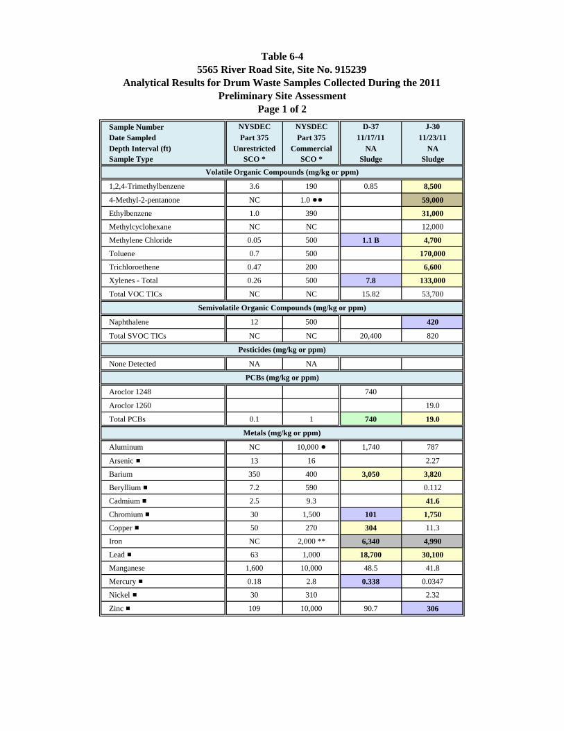
Table 6-45565 River Road Site, Site No. 915239
Analytical Results for Drum Waste Samples Collected During the 2011Preliminary Site Assessment
Page 1 of 2Sample Number NYSDEC NYSDEC D-37 J-30Date Sampled Part 375 Part 375 11/17/11 11/23/11Depth Interval (ft) Unrestricted Commercial NA NASample Type SCO * SCO * Sludge Sludge
1,2,4-Trimethylbenzene 3.6 190 0.85 8,500
4-Methyl-2-pentanone NC 1.0 !! 59,000
Ethylbenzene 1.0 390 31,000
Methylcyclohexane NC NC 12,000
Methylene Chloride 0.05 500 1.1 B 4,700
Toluene 0.7 500 170,000
Trichloroethene 0.47 200 6,600
Xylenes - Total 0.26 500 7.8 133,000
Total VOC TICs NC NC 15.82 53,700
Naphthalene 12 500 420
Total SVOC TICs NC NC 20,400 820
None Detected NA NA
Aroclor 1248 740
Aroclor 1260 19.0
Total PCBs 0.1 1 740 19.0
Aluminum NC 10,000 ! 1,740 787
Arsenic # 13 16 2.27
Barium 350 400 3,050 3,820
Beryllium # 7.2 590 0.112
Cadmium # 2.5 9.3 41.6
Chromium # 30 1,500 101 1,750
Copper # 50 270 304 11.3
Iron NC 2,000 ** 6,340 4,990
Lead # 63 1,000 18,700 30,100
Manganese 1,600 10,000 48.5 41.8
Mercury # 0.18 2.8 0.338 0.0347
Nickel # 30 310 2.32
Zinc # 109 10,000 90.7 306
Volatile Organic Compounds (mg/kg or ppm)
Semivolatile Organic Compounds (mg/kg or ppm)
Pesticides (mg/kg or ppm)
PCBs (mg/kg or ppm)
Metals (mg/kg or ppm)
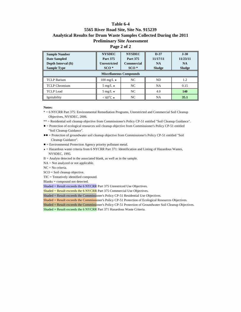
Table 6-45565 River Road Site, Site No. 915239
Analytical Results for Drum Waste Samples Collected During the 2011Preliminary Site Assessment
Page 2 of 2Sample Number NYSDEC NYSDEC D-37 J-30Date Sampled Part 375 Part 375 11/17/11 11/23/11Depth Interval (ft) Unrestricted Commercial NA NASample Type SCO * SCO * Sludge Sludge
TCLP Barium 100 mg/L ’ NC ND 1.2
TCLP Chromium 5 mg/L ’ NC NA 0.15
TCLP Lead 5 mg/L ’ NC 4.0 140
Ignitability < 60oC ’ NC NA 35.1
Notes:* = 6 NYCRR Part 375: Environmental Remediation Programs, Unrestricted and Commercial Soil Cleanup Objectives, NYSDEC, 2006.** = Residential soil cleanup objective from Commissioner's Policy CP-51 entitled "Soil Cleanup Guidance".! = Protection of ecological resources soil cleanup objective from Commissioner's Policy CP-51 entitled "Soil Cleanup Guidance".!! = Protection of groundwater soil cleanup objective from Commissioner's Policy CP-51 entitled "Soil Cleanup Guidance".# = Environmental Protection Agency priority pollutant metal.’ = Hazardous waste criteria from 6 NYCRR Part 371: Identification and Listing of Hazardous Wastes, NYSDEC, 1995.B = Analyte detected in the associated blank, as well as in the sample.NA = Not analyzed or not applicable.NC = No criteria.SCO = Soil cleanup objective.TIC = Tentatively identified compound.Blanks = compound not detected.Shaded = Result exceeds the 6 NYCRR Part 375 Unrestriced Use Objectives.Shaded = Result exceeds the 6 NYCRR Part 375 Commercial Use Objectives.Shaded = Result exceeds the Commissioner's Policy CP-51 Residential Use Objectives.Shaded = Result exceeds the Commissioner's Policy CP-51 Protection of Ecological Resources Objectives.Shaded = Result exceeds the Commissioner's Policy CP-51 Protection of Groundwater Soil Cleanup Objectives.Shaded = Result exceeds the 6 NYCRR Part 371 Hazardous Waste Criteria.
Miscellaneous Compounds
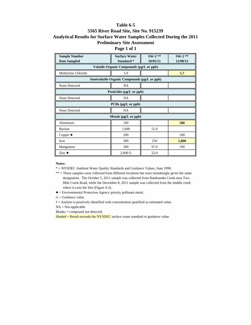
Table 6-55565 River Road Site, Site No. 915239
Analytical Results for Surface Water Samples Collected During the 2011Preliminary Site Assessment
Page 1 of 1Sample Number Surface Water SW-2 ** SW-2 **Date Sampled Standard * 10/05/11 12/08/11
Methylene Chloride 5.0 5.7
None Detected NA
None Detected NA
None Detected NA
Aluminum 100 280
Barium 1,000 51.0
Copper # 200 100
Iron 300 250 1,600
Manganese 300 97.0 190
Zinc # 2,000 G 22.0
Notes:* = NYSDEC Ambient Water Quality Standards and Guidance Values, June 1998.** = These samples were collected from different locations but were mistakengly given the same designation. The October 5, 2011 sample was collected from Rattlesnake Creek near Two Mile Creek Road, while the December 8, 2011 sample was collected from the middle creek where it exits the Site (Figure 4-3).# = Environmental Protection Agency priority pollutant metal.G = Guidance value.J = Analyte is positively identified with concentration qualified as estimated value.NA = Not applicable.Blanks = compound not detected.Shaded = Result exceeds the NYSDEC surface water standard or guidance value.
Volatile Organic Compounds (µg/L or ppb)
Semivolatile Organic Compounds (µg/L or ppb)
Pesticides (µg/L or ppb)
PCBs (µg/L or ppb)
Metals (µg/L or ppb)
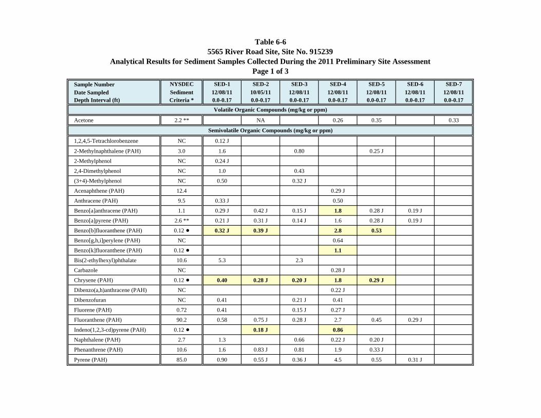
Table 6-65565 River Road Site, Site No. 915239
Analytical Results for Sediment Samples Collected During the 2011 Preliminary Site AssessmentPage 1 of 3
Sample Number NYSDEC SED-1 SED-2 SED-3 SED-4 SED-5 SED-6 SED-7Date Sampled Sediment 12/08/11 10/05/11 12/08/11 12/08/11 12/08/11 12/08/11 12/08/11Depth Interval (ft) Criteria * 0.0-0.17 0.0-0.17 0.0-0.17 0.0-0.17 0.0-0.17 0.0-0.17 0.0-0.17
Acetone 2.2 ** NA 0.26 0.35 0.33
1,2,4,5-Tetrachlorobenzene NC 0.12 J
2-Methylnaphthalene (PAH) 3.0 1.6 0.80 0.25 J
2-Methylphenol NC 0.24 J
2,4-Dimethylphenol NC 1.0 0.43
(3+4)-Methylphenol NC 0.50 0.32 J
Acenaphthene (PAH) 12.4 0.29 J
Anthracene (PAH) 9.5 0.33 J 0.50
Benzo[a]anthracene (PAH) 1.1 0.29 J 0.42 J 0.15 J 1.8 0.28 J 0.19 J
Benzo[a]pyrene (PAH) 2.6 ** 0.21 J 0.31 J 0.14 J 1.6 0.28 J 0.19 J
Benzo[b]fluoranthene (PAH) 0.12 ! 0.32 J 0.39 J 2.8 0.53
Benzo[g,h,i]perylene (PAH) NC 0.64
Benzo[k]fluoranthene (PAH) 0.12 ! 1.1
Bis(2-ethylhexyl)phthalate 10.6 5.3 2.3
Carbazole NC 0.28 J
Chrysene (PAH) 0.12 ! 0.40 0.28 J 0.20 J 1.8 0.29 J
Dibenzo(a,h)anthracene (PAH) NC 0.22 J
Dibenzofuran NC 0.41 0.21 J 0.41
Fluorene (PAH) 0.72 0.41 0.15 J 0.27 J
Fluoranthene (PAH) 90.2 0.58 0.75 J 0.28 J 2.7 0.45 0.29 J
Indeno(1,2,3-cd)pyrene (PAH) 0.12 ! 0.18 J 0.86
Naphthalene (PAH) 2.7 1.3 0.66 0.22 J 0.20 J
Phenanthrene (PAH) 10.6 1.6 0.83 J 0.81 1.9 0.33 J
Pyrene (PAH) 85.0 0.90 0.55 J 0.36 J 4.5 0.55 0.31 J
Volatile Organic Compounds (mg/kg or ppm)
Semivolatile Organic Compounds (mg/kg or ppm)
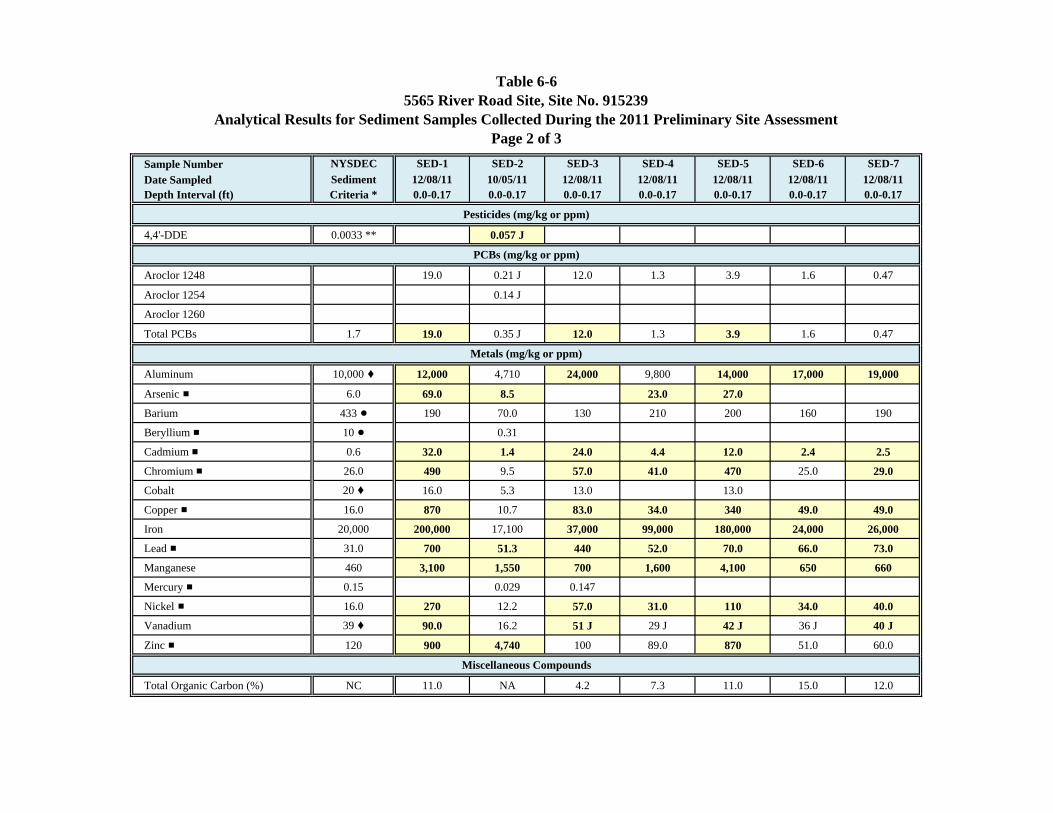
Table 6-65565 River Road Site, Site No. 915239
Analytical Results for Sediment Samples Collected During the 2011 Preliminary Site AssessmentPage 2 of 3
Sample Number NYSDEC SED-1 SED-2 SED-3 SED-4 SED-5 SED-6 SED-7Date Sampled Sediment 12/08/11 10/05/11 12/08/11 12/08/11 12/08/11 12/08/11 12/08/11Depth Interval (ft) Criteria * 0.0-0.17 0.0-0.17 0.0-0.17 0.0-0.17 0.0-0.17 0.0-0.17 0.0-0.17
4,4'-DDE 0.0033 ** 0.057 J
Aroclor 1248 19.0 0.21 J 12.0 1.3 3.9 1.6 0.47
Aroclor 1254 0.14 J
Aroclor 1260
Total PCBs 1.7 19.0 0.35 J 12.0 1.3 3.9 1.6 0.47
Aluminum 10,000 ‚ 12,000 4,710 24,000 9,800 14,000 17,000 19,000
Arsenic # 6.0 69.0 8.5 23.0 27.0
Barium 433 ! 190 70.0 130 210 200 160 190
Beryllium # 10 ! 0.31
Cadmium # 0.6 32.0 1.4 24.0 4.4 12.0 2.4 2.5
Chromium # 26.0 490 9.5 57.0 41.0 470 25.0 29.0
Cobalt 20 ‚ 16.0 5.3 13.0 13.0
Copper # 16.0 870 10.7 83.0 34.0 340 49.0 49.0
Iron 20,000 200,000 17,100 37,000 99,000 180,000 24,000 26,000
Lead # 31.0 700 51.3 440 52.0 70.0 66.0 73.0
Manganese 460 3,100 1,550 700 1,600 4,100 650 660
Mercury # 0.15 0.029 0.147
Nickel # 16.0 270 12.2 57.0 31.0 110 34.0 40.0
Vanadium 39 ‚ 90.0 16.2 51 J 29 J 42 J 36 J 40 J
Zinc # 120 900 4,740 100 89.0 870 51.0 60.0
Total Organic Carbon (%) NC 11.0 NA 4.2 7.3 11.0 15.0 12.0
Miscellaneous Compounds
Pesticides (mg/kg or ppm)
PCBs (mg/kg or ppm)
Metals (mg/kg or ppm)
Table 6-65565 River Road Site, Site No. 915239
Analytical Results for Sediment Samples Collected During the 2011 Preliminary Site AssessmentPage 3 of 3
Sample Number NYSDEC SED-1 SED-2 SED-3 SED-4 SED-5 SED-6 SED-7Date Sampled Sediment 12/08/11 10/05/11 12/08/11 12/08/11 12/08/11 12/08/11 12/08/11Depth Interval (ft) Criteria * 0.0-0.17 0.0-0.17 0.0-0.17 0.0-0.17 0.0-0.17 0.0-0.17 0.0-0.17
Notes:* = NYSDEC Technical Guidance for Screening Contaminated Sediments, January 1999. Sediment criteria calculated using a total organic carbon content of 8.85%. Sediment criteria given are for the protection of benthic aquatic life from chronic toxicity (organics) and the lowest effect level (metals) unless otherwise noted.** = 6 NYCRR Part 375: Environmental Remediation Programs, Soil Cleanup Objectives for the Protection of Ecological Resources, NYSDEC, 2006.! = Sediment criteria for the protection of human health bioaccumulation. ‚ = Protection of ecological resources soil cleanup objective from Commissioner's Policy CP-51 entitled "Soil Cleanup Guidance", NYSDEC, 2010.# = Environmental Protection Agency priority pollutant metal.J = Analyte is positively identified with concentration qualified as estimated value.NA = Not analyzed.NC = No criteria.PAH = Polycyclic aromatic hydrocarbon.Blanks = compound not detected.Shaded = Result exceeds the NYSDEC sediment criteria.
APPENDICES (APPENDICES DELETED
DUE TO SIZE CONSTRAINTS)