Embed Size (px)
DESCRIPTION
Preparing for the Tokai Earthquake. Mark Simpson Multicultural Affairs Division. Today’s Schedule. 11:15am~12:00pm Earthquake Presentation and Video No Earthquake Truck.. Further English Information: http://www.e-quakes.pref.shizuoka.jp/center/guidebook/english/index.html - PowerPoint PPT Presentation
Citation preview

Preparing for the Tokai Earthquake
Mark SimpsonMulticultural Affairs Division

Today’s Schedule
11:15am~12:00pm
Earthquake Presentation and Video
No Earthquake Truck..
Further English Information:
http://www.e-quakes.pref.shizuoka.jp/center/guidebook/english/index.html
Main source of information (Japanese):http://www.pref.shizuoka.jp/bousai/4higaisoutei/shiryou.html

Mechanisms of an Earthquake
Tectonic plates cover the surface of the Earth 15 major plates 4 plates lie under Japan (and 3 meet in Shizuoka
Prefecture)

Mechanisms of an Earthquake
Tectonic plates can move up to 10cm a year Energy is released when plates bump and slide

Earthquake Measurements
Richter Scale (1-10) Represents an
earthquake's overall energy and size.
Japanese Scale of Seismic Intensity (1-7) Represents the size of
tremors that happen at a specific location.
0 Cannot feel tremors
1 Slight tremors if indoors
2 Tremors if indoors
3 Tremors if indoors, people may be frightened
4 Almost all who are sleeping will be awoken
Weak 5 Some will have difficulty moving around
Strong 5 Most will have difficulty moving around
Weak 6 Difficult to remain standing
Strong 6 Impossible to stand; must crawl to move
7 Impossible to control any movements
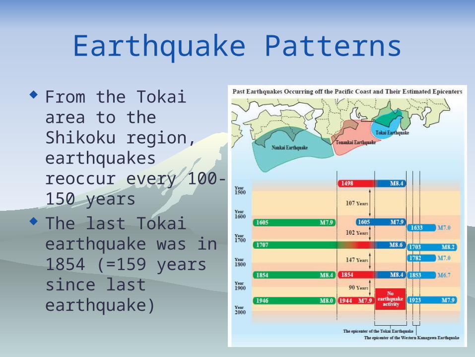
Earthquake Patterns
From the Tokai area to the Shikoku region, earthquakes reoccur every 100-150 years
The last Tokai earthquake was in 1854 (=159 years since last earthquake)

Historic Earthquakes

August 11, 2009
Magnitude 6.5 Seismic Intensity of weak 6 in Izu City,
Makinohara, Yaizu, and Omaezaki Strong 5, weak 5, or 4 in most of Shizuoka
Prefecture Tsunami of 60cm off the coast of Yaizu (6
minutes after the initial quake) Not related to the predicted Tokai Earthquake

August 11, 2009 (5:07a.m.)

August 1, 2011
Magnitude 6.1 Seismic Intensity of weak 5 in Shizuoka City,
Shimizu and Ito Seismic Intensity of 3 or 4 in most of
prefecture 13 injured and 27 houses damaged No tsunami generated Not related to the predicted Tokai Earthquake

August 1, 2011 (11:58p.m.)

The Main Earthquakes
Based on a quake at middle of night in winter
Category/Location Suruga/Nankai Trough Sagami Trough
Level 1 Tokai EarthquakeTokai/Tonankai EQTokai/Tonankai/Nankai
M8 Kanto Quake
Level 2 Nankai Trough Superquake
M8.2 Kanto Quake
Sagami Trough Level 1 Level 2
Shindo 7 Area 42km2 109km2
1cm or more tsunami 7.4km2 21.1km2
2m or more tsunami 1.1km2 4.3km2
Houses collapsed/burned 14,000 21,000
Deaths 3,000 6,000
Number of deaths from tsunami
2,900 5,700
Nankai Trough Level 1(Tokai Earthquake)
Level 2(Nankai Superquake)
Shindo 7 Area 344km2 344 to 732km2
1cm or more tsunami 28.8km2 158km2
2m or more tsunami 9.0km2 68.5km2
Houses collapsed/burned 260,000 300,000
Deaths 16,000 105,000 ⇒ 14,000
Number of deaths from tsunami
9,000 96,000

What is actually going on?
Eurasian Plate Philippine Sea Plate

What is actually going on?

Can it be predicted?
Use strain gauges and GPS altimeters 14 Volume strain gauges 8 Multi-component strain gauges 197 GPS facilities


Types of strain gauge
● Volume strain gauge ▲ ◆ Multi-component strain gauge

What can we tell with GPS?

Tokai Advisory/Warning

When an Earthquake Occurs
Stay calm Protect yourself Turn off your gas Secure an exit Stay away from windows or heavy objects

After an earthquake
Stay calm and be aware of aftershocks If in a low lying area, IMMEDIATELY seek
higher ground Fill your bathtub if possible Turn off your electricity at the mains Grab your emergency kit Head to your nearest evacuation centre
-BUT leave a note on your door explaining where you are!!!

Emergency Kit

Stockpile Items

Safety Measures Do not place large objects where you sleep Secure large objects (cabinets, televisions,
refrigerators) if possible Protective film on glass doors and windows
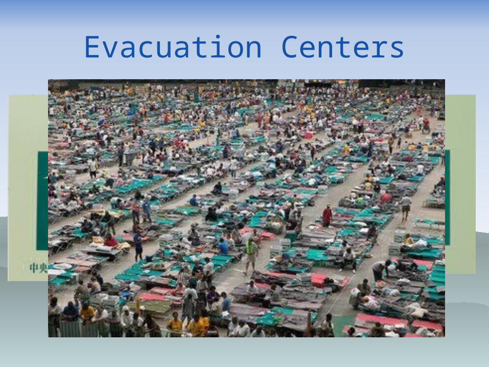
Evacuation Centers

Tsunami Evacuation Centers

Dengon Dial
Activated after a disaster Call 171, then 1, then your phone number to
record a message Message length 30 seconds, up to 10 Call 171, then 2, then their phone number to
listen to up to 10 recorded messages Need a land line phone number

Tsunami Tidal Waves
Tidal waves of up to 33min are expected to hit Shizuoka Prefecture before the shaking even subsides
Evacuate to high ground IMMEDIATELY following a large earthquake!

Tsunami Tidal Waves

Tsunami Arrival Time

Liquefaction
Large area of Shizuoka Prefecture to be affected
52% of Fukuroi City at risk Places closer to water have greatest risk

Tokai – Tonankai – Nankai
Tokai – At any moment Tonankai - 10% within 10 years
60% within 30 years80-90% within 50 years
Nankai – 10% within 10 years40% within 30 years60% within 50 years
(2004 est.)

Advanced Warning System

March 15, 2011 (10:31p.m.)
Magnitude 6.4, Depth of 14km. Seismic Intensity of strong 6 in Fujinomiya
City Seismic Intensity 3-5 in most of prefecture No tsunami generated Not related to the predicted Tokai Earthquake

Eruption possibility?
All 5 mag. 9+ quakes of 2nd half of 20th century resulted in a major eruption with 3 years.
A magma pocket is thought to be situated 15km beneath Fujinomiya.
Continuous flow of water for months after. New fault discovered capable of Mag. 7 directly
under Mt. Fuji – more research needed.

Other types of natural disasters
Typhoons Landslides Nuclear related? Keikaku Teiden (Scheduled Blackouts)

www.facebook.com/infoshizuoka.eng