Embed Size (px)
Citation preview

Presented by Mission Foundation’s Community Health Enhancement Program,
Tortoise & Hare, and Quality Forward

TThe Walking Guide toBuncombe County was
created to provide for you acomprehensive guide toBuncombe County’s walkingtrails. These many trails offeropportunities for healthfulrecreation and appreciation ofculturally, historically, andenvironmentally significantareas. They are valuable for theirenhancement of the community,both aesthetically andeconomically, and as a means tobring people together. Thesewalks provide ampleopportunities for recreation andexercise. In addition, they offertransportation alternatives that
About the Walking Guide toAsheville & Buncombe County
influence our personal wellnessand the wellness of ourenvironment by reducing trafficcongestion and improving airand water quality.
This guide is by no means anall-inclusive list of the walks thatBuncombe County has to offer.We have chosen to highlight17 walks that are easy to accessand that showcase some ofAsheville’s beautiful parks andneighborhoods. Pedestrians areencouraged to strike out andexplore other walks in the area,tailoring each excursion to fittheir needs. We wish you thebest in your walking adventures!
About the Walking Guide toAsheville & Buncombe County

Pedestrian Safety Tips
BE VISIBLE. The more visible youare, the safer you will be. Wearlight-colored or reflectiveclothing, especially in stormyweather or at night. Carry aflashlight at night to see and beseen.
BE ALERT at intersections. Makesure that motorists have seenyou before you step off the curb.Do not assume that a motoristwill stop – you have a lot more tolose! Cross streets atintersections.
Driveway and alley crossingsrequire extra attention. Oftenmotorists do not expect oranticipate pedestrians. Becautious at path intersections.
BE CONSIDERATE on multi-usepaths. These paths are availablefor many uses and many users –including runners, in-line skaters,bicyclists, and pedestrians. Walkto the right side of multi-usepaths, allowing room for othersto pass you on the left. Dogsmust be on a leash. Whenseparate pedestrian paths areavailable, use them.
Look for unusual obstacles.Uneven sidewalks and debris aresometimes difficult to see,especially at night or in stormyweather.
Health Benefits
of Walking
Strengthens your heart
Increases the efficiencyof your lungs in using
oxygen
Improves endurance forcoping with everyday
activities
Cuts down on your riskof heart disease
Lowers your resting pulserate as well as your
blood pressure
Burns calories
Relaxes tense muscles andincreases the production
of endorphins
Reduces stress and anxiety
Promotes bettersleep habits
Strengthens bones,decreasing your chance
of osteoporosis

1 Riverside Cemetery2 Urban Trail3 Lake Louise4 UNCA’s Botanical Gardens &
Weaver Blvd.5 Kimberly Ave. & Griffing Blvd.
Rose Garden6 Beaver Lake & Bird Sanctuary
7 Big Ivy Community Club8 Lake Tomahawk9 Charles D. Owen Park10 Warren Wilson College
Trails11 Lake Julian12 Swannanoa River Greenway,
Thompson St.
*This location map is not to scaleand is only intended as anapproximation for the locations ofthe walks. For more detaileddirections, consult a local map orcall Quality Forward at 828.254.1776.
13 Bent Creek ExperimentalForest, the North CarolinaArboretum and Bent CreekPark & Garden
14 Buncombe County Sports Park15 French Broad River Parks16 Malvern Hills Park17 Leicester Elementary School
Other Walks
Walks Through
Scenic Neighborhoods
Beverly Hills Subdivision
Kenilworth Neighborhood
Malvern Hills Subdivision
West Asheville Neighborhoods
Biltmore Forest
Montford Neighborhood
Kimberly Neighborhood
Grove Park Neighborhood
Walks with Historical Sites
AB-Tech Community College
Downtown Urban Trail
Montford Community
Walks for Aerobic Pacing
Asheville Mall
River Ridge Shopping Center
UNCA Track
Biltmore Square Mall
Area high school tracks

Asheville Amblersc/o Dennis Michele
828.628.4343
Asheville Track Clubc/o Wayne Stanko
828.253.8781
Mall Walkersc/o Amy Smialowicz
Care Partners828.277.4800 x4640
Carolina Mountain Clubc/o Donald E. Walton
828.298.5084
Healthy Buncombec/o Terri March828.250.5047
Strive Not to Drivec/o Linda Giltz
Land-of-the-Sky Regional Council828.251.6622
Asheville Parks & Recc/o Katy Palombi
828.254.5561
Bikeway & Pedestrian Task Force
c/o Jeff Burns828.259.5534
Buncombe County Parks& Recreation828.298.6118
Buncombe County’s
Walking Associations
& Park Contacts
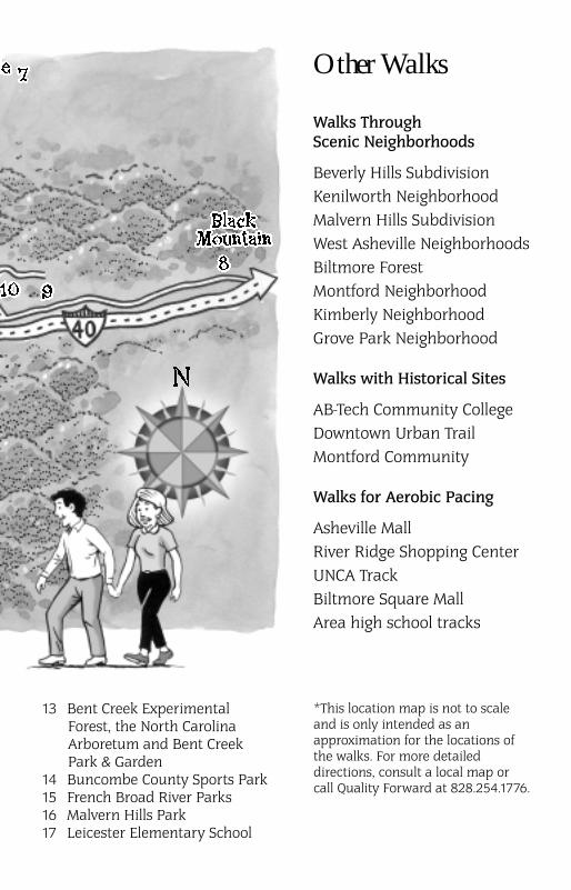
Riverside Cemetery
Riverside Cemetery offers thewalker a stroll through history aswell as beautiful views of themountaintops. Located in theMontford Historic District,Riverside boasts magnificent oldtrees and monuments, dating tothe early 1800s, strewn about thegrassy hillsides. The cemeteryhas ample shade, stone benches,and paved pathways windingthrough 87 acres. Be on thelookout for the gravestones ofIsaac Dickson, O. Henry, ThomasWolfe, and many other notablehistoric figures!
Length 1 mileDifficulty ModerateDirections Heading away fromdowntown on Montford Ave.,take a left onto Chestnut St. Takea right onto Pearson and thentake a left onto Birch St. This willtake you through the gates.
Urban Trail
The Urban Trail is a walk throughdowntown Asheville thathighlights architecture, historicalsights, and lively public spacesunique to the area. Take note ofthe sculptures and plaques thatdefine the trail and honor thepeople and events that haveshaped Asheville’s history. Pinkgranite markers embedded inthe sidewalk display icons forfive periods of the city’ssocial history.
Length 1.7 milesDifficulty EasyDirections Strike out on yourown downtown and look for themarkers or purchase an UrbanTrail map at one of theselocations: the Arts Council Office,(11 Biltmore Ave.), Pack Place,the Asheville Art Museum, theChamber of Commerce, orQuality Forward.
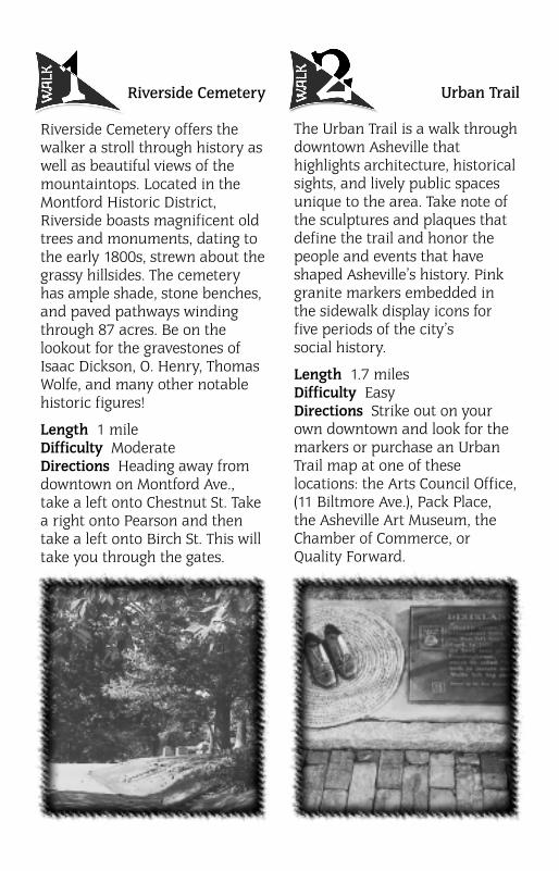
Lake Louise
On the North end of BuncombeCounty, in Weaverville, liesbeautiful Lake Louise. A gravelpath leads you around the shoresof the entire lake as well asthrough the picnic and play area.On any given day, you will seepeople fishing and enjoying thefamily picnic and playgroundfacilities while a host of otherswalk and jog on the sunny path.A fountain in the middle of thelake sprays a continuous streamof water that the ducks seemto love!
Length .6 milesDifficulty EasyDirections Go north on Hwy. 25(Merrimon Ave.) – it will turn intoBusiness 19-23 out of town – allthe way to Weaverville. LakeLouise will be on your left abouta mile from the town limits.

UNCA’s
Botanical Gardens
& Weaver Boulevard
The Botanical Gardens atUNC-Asheville are on a 10-acrepreserve south of campus.Featuring thousands of labeledplants and trees native to theSouthern Appalachians, thegardens are a refuge for wildlifeand a source of enjoyment forcommunity walkers. Much of the10 acres is landscaped withnative flora displayed in theirnatural setting. During yourwalk, you can stroll over woodenbridges and rest on the shadedbenches or at the picnic tables.Along the length of WeaverBoulevard runs a paved
multi-use trail that joins theBotanical Gardens withMerrimon Avenue.
Length .5 mile loop inBotanical Gardens, .5 milesalong Weaver Blvd.Difficulty EasyDirections Head north onHwy. 25 (Merrimon Ave.) out ofdowntown. Take a left at a lightonto Weaver Blvd. Along theright side of Weaver Blvd. runsone walking trail. After the trafficcircle in front of UNCA, theBotanical Gardens will be onthe right.

Kimberly Avenue &
Griffing Boulevard
Rose Garden
Located just north of downtown,this walk takes you through oneof Asheville’s oldest and mostbeautiful neighborhoods. You willcatch glimpses of the Grove ParkInn and golf course, beautifularchitecture, and hundreds ofrose bushes that bloombrilliantly in spring and summer.The sidewalks of KimberlyAvenue, often bustling with avidpedestrians, are lined with largetrees that provide shade.
Length 2.1 milesDifficulty ModerateDirections Park along KimberlyAve. (heading north). Begin yourwalk by taking a right onCountry Club Rd., a right onGrovewood Rd., left on LynnwoodRd., right on Griffing Blvd., lefton Blackwood Rd., crossKimberly Ave., left on ManettaRd., left on Gracelyn, and righton Kimberly Ave.
Beaver Lake
& Bird Sanctuary
Just north of downtown you willfind Beaver Lake, a 67-acre lakethat has provided recreationalopportunities in the LakeviewPark neighborhood since thedamming of Beaver Creek in1921. The walk around this lakewill afford you beautiful views ofthe surrounding mountains,sunny, grassy picnic spots, andthe company of people fishingand canoeing. A gravel path willtake you part of the way aroundthe lake and the Hwy. 25(Merrimon Ave.) sidewalk willtake you south to the birdsanctuary. The adjoining BeaverLake Bird Sanctuary offersopportunities to spot many birdsin the area. With some luck, youmay spot a Warbling Vireo orhear its raspy song.
Length .7 miles Difficulty EasyDirections Head north onHwy. 25 (Merrimon Ave.). Thelake will be on your left after theroad turns to two lanes. The birdsanctuary will be on the left justbefore you reach the lake. Lookfor stone pillars at the entranceof two driveways. Here you willfind the sanctuary parking lot.

Big Ivy
Community Club
In Barnardsville, at the Big IvyCommunity Club, is a dirtwalking path that leads you by aswimming pool, picnic area, ballfield, resource center, and aplayground that Quality Forwardhelped build. You may also catcha glimpse of the restored CarsonCabin from the path.
Length .3 milesDifficulty EasyDirections Take 19-23 north tothe Barnardsville/Jupiter exit.Make a right onto Hwy. 197 anddrive about 6 miles. Make a rightonto Dillingham Rd. Go 1.5 miles.On the left will be the resourcecenter.

Lake Tomahawk
Lake Tomahawk, in BlackMountain, offers a well-lit levelpath for safe strolling in theevening or daytime. Adjacent tothe lake are open, lighted tenniscourts and a children’splayground. You will also find acovered picnic pavilion,horseshoe pits, an outdoor stage,and fishing piers. Benches alongthe path invite you to rest afteryour walk and identify the peaksof the spectacular Seven Sistersmountains.
Length .55 milesDifficulty EasyDirections Head east on US 70.Just before Black Mountain, takea left onto Craigmont Rd. nearthe CVS pharmacy. Take a rightonto Tomahawk Rd. The lake willbe on your right and parking isjust beyond the lake.

Charles
D. Owen Park
This facility provides a scenicwalk around a pond in thebeautiful Swannanoa Valley. Partof the walk runs along the dambetween the pond and theSwannanoa River, an ideal spotfor bird-watching. In addition,you will find baseball fields,basketball courts, restrooms, aplayground, picnic tables, twolarge pavilions with fireplacesand grills for your excursion.
Length .3 milesDifficulty EasyDirections Take I-40 East toexit 55. At the end of ramp, turnleft and travel to US 70 East.Turn right on US 70 East, go1.7 miles and take a left ontoWarren Wilson College Rd. Travel2.5 miles. You will see the signto the park on the right.
Warren Wilson
College Trails
These trails offer the walker avariety of exercise opportunities,from challenging hikes to easystrolls. They will lead youthrough 1,000 acres of woodland,managed forests, pastures, andstreams. You can also catchglimpses of the bustle of collegelife. There are a few markedmulti-use trails for bikers. Pick upa trail map at the administrationbuilding for details on trails anddirections to trail heads.
Length Over 25 miles of trails,all varying in lengthDifficulty Easy, Moderate, andDifficultDirections Drive east on US 70.Take a left onto Warren WilsonCollege Rd. Several trail headsbegin off of this road and someembark from campus.
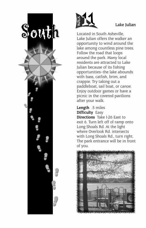
Lake Julian
Located in South Asheville,Lake Julian offers the walker anopportunity to wind around thelake among countless pine trees.Follow the road that loopsaround the park. Many localresidents are attracted to LakeJulian because of its fishingopportunities–the lake aboundswith bass, catfish, brim, andcrappie. Try taking out apaddleboat, sail boat, or canoe.Enjoy outdoor games or have apicnic in the covered pavilionsafter your walk.
Length .5 milesDifficulty EasyDirections Take I-26 East toexit 6. Turn left off of ramp ontoLong Shoals Rd. At the lightwhere Overlook Rd. intersectswith Long Shoals Rd., turn right.The park entrance will be in frontof you.

Swannanoa River
Greenway,
Thompson Street
A short jaunt from BiltmoreVillage is a lovely walk along theSwannanoa River. QualityForward has worked tolandscape and clean up thisgreenway for the well-being ofthe river and forthe community’s aestheticenjoyment. A mulched trail runsalong part of the greenway.Walkers can continue to walk thelength of the greenway on thegrass or road after the trail ends.
Length 1 mile (entire greenway)Difficulty EasyDirections From downtownAsheville, take Hwy. 25 South.Just before you reach BiltmoreVillage and the train tracks, takea left onto Thompson St. Thegreenway trail and river areimmediately on your left.
(1) NC Arboretum
(2) Bent Creek
Experimental Forest
(3) Bent Creek Park & Garden
The North Carolina Arboretum hasits own landscaped paths that willimmerse you in the botanicalheritage of the SouthernAppalachians. Bent CreekExperimental Forest, located withinPisgah National Forest, offers manywooded multi-use trails for theoutdoor enthusiast. Lake Powhatanis also located within this forest andhas a sandy beach. Nearby, you willfind a one-mile wood-mulched pathin Bent Creek Park and Garden.Neighbors have worked withQuality Forward to put a walkingpath around a new playground.
Length Miles of walking spreadover 20 trailsDifficulty Easy, Moderate, andDifficultDirections From I-26, take Hwy. 191,(1) 2 miles past Biltmore Square Mall,turn right into the NC Arboretumentrance at the Blue Ridge Parkway.(Parking Fee) (2) 1.5 miles from theMall, the parking areas (free) for theBent Creek trails are along WesleyBranch Rd. (off of Hwy. 191) headingtowards Lake Powhatan. (3) For theBent Creek Neighborhood Park andGarden, from Hwy. 191, take a righton Wesley Branch Rd., right onBent Creek Ranch Rd., left onSummerglen, and left onDonnybrook. The park will be onyour left.

Buncombe County
Sports Park
A new addition to Asheville, thisextensive sports complex has agravel walking path that runsalong the perimeter of thefacility and throughout. The flatpath will lead you by a coveredpavilion, volleyball court,multiple soccer fields, aplayground, and all of the sportsaction! Quality Forward hasworked with local schools,churches, and scout troops tolandscape the complex with treesfor shade, beauty and erosioncontrol.
Length .6 miles around outer loopDifficulty EasyDirections Take I-40 West to theEnka-Candler exit. Take a right offexit ramp. Go through next lightjust before McDonald’s. Take a rightonto Acton Circle, a left at 4-waystop onto Sand Hill Rd., and a rightinto the park between Sand HillVenable School and the BuncombeCommunity School West.
French Broad
River Parks
These three adjacent parks aresome of Asheville’s newest andmost frequently used. The14-acre French Broad River Parkis located along the banks of theriver and offers paved walkingpaths and a quarter-mile trackfor both pedestrians andbicyclists. In addition, within theboundary of the track, there is aroller hockey rink, full basketballcourt, sand volleyball courts, anda fenced playground. The pavedwalking path winds by thebaseball and soccer field, anopen grassy area for Frisbees andkite-flying, and a lawn-bowlingcourt. Just a quarter-mile east ofthis park is the Amboy RoadPark. Here you will find a pavedwalking path that runs along theriver. Shaded grassy areas andwooden piers overlooking theriver make this an ideal picniclocation after your walk. At theeast end of this park, and justacross Amboy Road, is the DogPark, an extension of the FrenchBroad River Park. Here you cancontinue your walk or let yourdog get some exercise. This areaalso has covered picnic pavilionsand river overlooks.
Length Approximately 3 miles ofpaths between the three parks Difficulty Easy
Continued

Directions From Hwy. 25, takeMeadow Rd. near BiltmoreVillage. Turn left on Amboy Rd.at light. The Dog Park will be
Continued from previous page
Leicester
Elementary School
West of Asheville, off of LeicesterHighway, you will find a pavedwalking path at LeicesterElementary. This walk is locatedin an open, grassy field thatallows ample sunshine to warmyou throughout your stroll. Thepath wraps around the newplayground that Quality Forwardvolunteers helped construct.
Length .25 milesDifficulty EasyDirections From downtownAsheville, head west on PattonAve. (Business 19-23). Take a rightonto Leicester Hwy. at the light byIngles. Follow this highway8.5 miles and take a right onGilbert Rd. The school will be onyour left.
Malvern Hills Park
This lovely park in the heart ofWest Asheville has a wide, pavedpath winding among its otherrecreational features. Childrenwill love the playground andopen grassy spaces. The wholefamily can enjoy the pool andrecreation house in the summer,two lighted tennis courts, onelarge covered picnic pavilion,grills, a wooden bridge, and largetrees that provide ample shade.
Length .5 milesDifficulty EasyDirections Heading west onPatton Ave. (Business 19-23), takea left onto Rumbough Ave. Aftercrossing Sulphur Springs Rd., thepark will be on your right.
immediately on the right.Parking for the Amboy Rd. Parkwill be your first left, and parkingfor the French Broad River Parkwill be 1 mile down on your left.

Quality Forward would like to thank Mission Foundation’s Community Health Enhancement Program
and Tortoise & Hare for sponsoring The Walking Guide to Asheville & Buncombe County
Sponsors
Suite 145 • One Town Square • Asheville, NC 28803Take I-26 E to exit 37 (old exit 6) • Biltmore Park
828.681.5325
www.thrunning.com
Our qualified staff will take the time to fit you with the proper shoe.
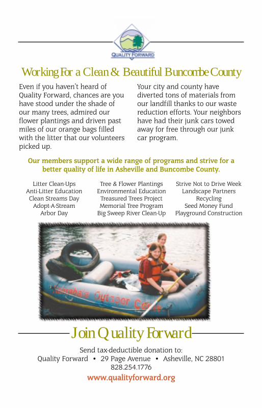
Even if you haven’t heard ofQuality Forward, chances are youhave stood under the shade ofour many trees, admired ourflower plantings and driven pastmiles of our orange bags filledwith the litter that our volunteerspicked up.
Your city and county havediverted tons of materials fromour landfill thanks to our wastereduction efforts. Your neighborshave had their junk cars towedaway for free through our junkcar program.
Litter Clean-Ups Anti-Litter Education Clean Streams Day
Adopt-A-StreamArbor Day
Tree & Flower PlantingsEnvironmental Education
Treasured Trees ProjectMemorial Tree Program
Big Sweep River Clean-Up
Strive Not to Drive WeekLandscape Partners
RecyclingSeed Money Fund
Playground Construction
Join Quality ForwardSend tax-deductible donation to:
Quality Forward • 29 Page Avenue • Asheville, NC 28801828.254.1776
www.qualityforward.org
Our members support a wide range of programs and strive for abetter quality of life in Asheville and Buncombe County.
Working For a Clean & Beautiful Buncombe County