Embed Size (px)
Citation preview

ISoCaRP 15th Young Planning Professionals’ Report, Bilbao, Spain, 2005
41
Proposals on site
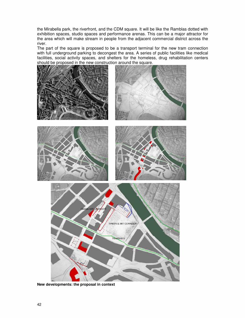
Activities proposed The proposal is to develop the CMD square into a major activity hub by introducing creative and support activities. The school will be relocated and the space available will be land-scaped into a river plaza overlooking the river. The proposal is to develop a series of floating decks on the river which will extend to the municipal market thereby activating the riverfront. The art museum in the basement of the school will be retained and the activities will be consolidated by support activities on the adjacent lots. Some new construction around the square will add an incubation centre, galleries, media centers etc. There is also a proposal for an extension of the art department of the university on the edge of the Mirabella Park with a proposal to link it up to the Bilbao Arte on the riverfront by a green art corridor. This is an open space network linking all the residual open spaces with
42
the Mirabella park, the riverfront, and the CDM square. It will be like the Ramblas dotted with exhibition spaces, studio spaces and performance arenas. This can be a major attractor for the area which will make stream in people from the adjacent commercial district across the river. The part of the square is proposed to be a transport terminal for the new tram connection with full underground parking to decongest the area. A series of public facilities like medical facilities, social activity spaces, and shelters for the homeless, drug rehabilitation centers should be proposed in the new construction around the square.
New developments: the proposal in context
ISoCaRP 15th Young Planning Professionals’ Report, Bilbao, Spain, 2005
43
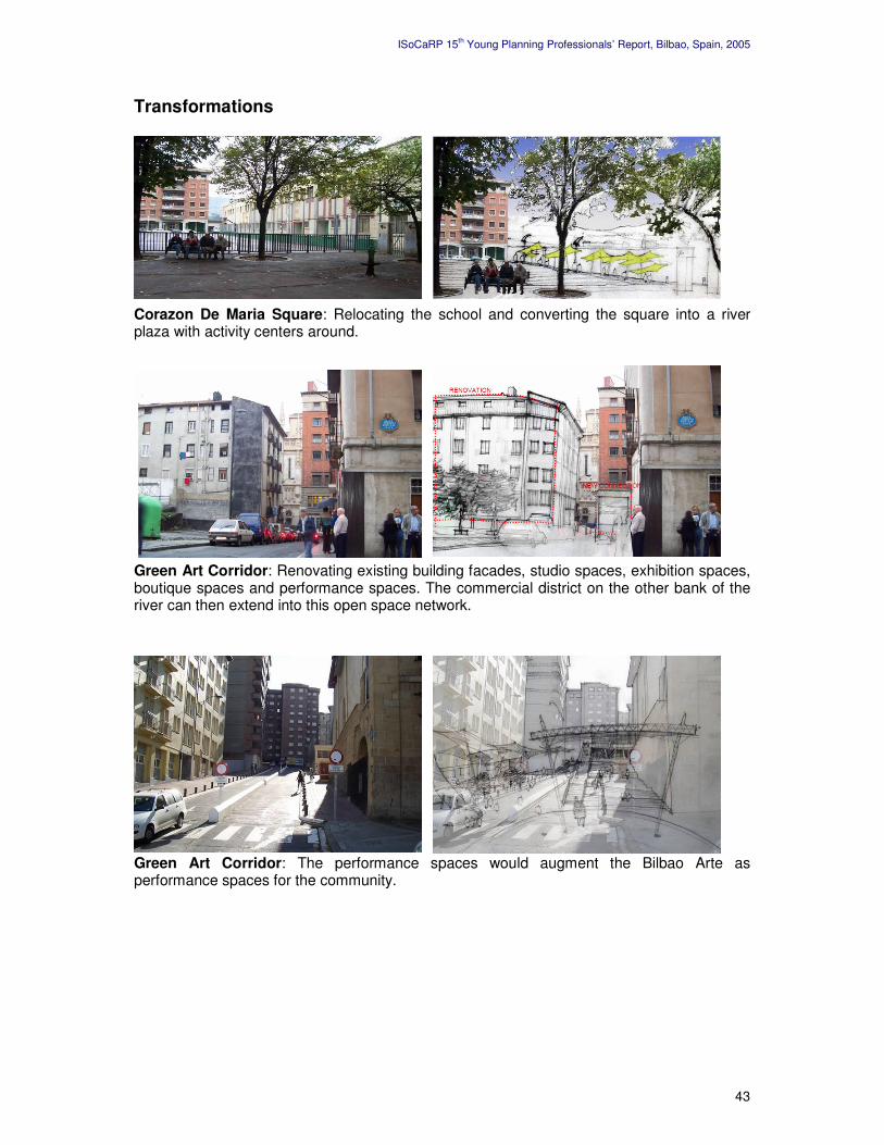
Transformations Corazon De Maria Square: Relocating the school and converting the square into a river plaza with activity centers around. Green Art Corridor: Renovating existing building facades, studio spaces, exhibition spaces, boutique spaces and performance spaces. The commercial district on the other bank of the river can then extend into this open space network.
Green Art Corridor: The performance spaces would augment the Bilbao Arte as performance spaces for the community.

44
Management plan Most of the property is believed to be private. Sufficient rehabilitation is to be provided to induce development. The school proposal is already under consideration by the authorities and compensation packages are believed to be already in place. The green art corridor requires minimum intervention into the built fabric. The demolitions can be compensated by Transfer of Development Rights (TDR) to other blocks in the same area. Wherever there is a requirement to free up private ownership at the groundfloor level for public access, a similar area will be allowed to be built on higher floors in the same property. To activate the green art corridor some building facades have to be redone where a suitable structural system can be devised. In order to raise funds for the project it might be essential to sell FAR in the development and later on put a levy on the parking facility. Conclusion It is believed that the development induced by tramways, the art university and the new river square will help to bring in people into the area, make it safer, provide new economic activities and help in an overall uplift of the social condition of the area. The model adopted in Al Raval and in the Pompidou center has been successful in delivering social justice to their respective areas. Similar logic has already been successful in Bilbao> Thus these inter-ventions will hopefully assist in the social improvement of the area.
Green Art Corridor: Activity network for the new art university to the river plaza.
Corazon De Maria Square: New transport terminal, underground parking and weekly flea market.

ISoCaRP 15th Young Planning Professionals’ Report, Bilbao, Spain, 2005
45
5. The Cantera Square and its Surroundings Contents Introduction Problems of the area Our proposals Concluding remarks
Evrim Ozkan (Turkey) Tolga Islam (Turkey) Maria Villalobos (Venezuela) Alvaro Cerezo (Spain)

46
Introduction The definition of the area Our study area, the La Cantera Square region, is located at the outer edge of the river. There is a large park on the north; the San Fransisco Street, one of the main axis that provides connection with the rest of the city, on the south, and old and dilapidated housing stock on the west and east side of the area. The park located on a vast land on the upper level is the most important environmental amenity in the area. It is also important to mention that the area above the Park is one of the remaining development areas of Bilbao. Starting point We have started our study by identifying the problems of the area and continued by using appropriate urban design tools to solve these problems and create a better and more pleasant environment for the local residents of the neighborhood and the residents and visitors of the city. Problems of the Area In our study area, we have identified problems related with accessibility, security, image and quality of life and classified them into two broad groups: problems related with accessibility and those related with image. In terms of accessibility, the La Cantera Square has two types of problems: accessibility with the Park (above) and accessibility with the river (below). The first problem is created by a physical barrier: the gap created by the 10 meters of wall between the La Cantera Square (at the bottom) and the Park (at the top) cuts the relation between the two levels. The square, currently, has no direct connections to the Park (the stairs, which look old and unsound, are closed for public use).
This gap of 10 meters between the Square and the Park does not only create physical separation. The gap also draws a sharp border between two different socio-economic groups: the rich above the park and the poor at the bottom. The middle and upper-middle classes live in the high-rise buildings located on the slopes of the park (the upper level) whereas lower classes, together with drug dealers and prostitutes, are living in the dilapidated housing stock at the lower level. Accessibility of the Square to and from the River is also problematic. Among the five study areas, La Cantera Square region is the one that is most far away from the river. Thus, the

ISoCaRP 15th Young Planning Professionals’ Report, Bilbao, Spain, 2005
47
link between the Square and the river, an important environmental amenity, is weak, both visually (despite the high altitude there are no viewpoints of the River or the land mark buildings like the Guggenheim or Euskalduna) and physically (there are no direct routes to the river). The poor or “bad” image of the area (a social rather than a physical barrier) also contributes to the problems of accessibility between the Square and the River. There is a general public opinion that the area is a “dangerous” and unsafe location (during our site visit, we were strictly warned by our local guides not to grow the distance from the group as it might be very dangerous). The presence of criminal and illegal social groups such as drug dealers and prostitutes are the main underlying reasons of this bad image. Other factors such as lack of open spaces (at the level of Square), lack of social and cultural activities that would attract neighboring residents and visitors, the old and dilapidated housing stock, and lower socio-economic profile of the residents are also factors that contributes to this “bad” image. Our Proposal
After defining the problem areas, we have proposed the following solutions in order to mitigate the current conditions. The ramp or the “gathering slope”:
� Our main concern was to solve the problems of accessibility. Our first and foremost proposal has been the creation of a ramp, which we defined as the “gathering slope” that connects the La Cantera Square with the Park both physically and visually.
� By creating activities at both levels, we tried to make a flow of people to both directions (from the square to the park and vice versa). The “gathering slope” will then be a meeting point between the two levels…
� The slope may also play a role to connect the rich up, with the poor down, helping to mitigate the problems caused by the years of segregation.
� The feeling that it is part of the topography

48
� Very wide � Openness � Increase the feeling of security by the users � Apart from the “gathering slope”, we put additional connecting elements like
elevators and stairs. The connection to the San Francisco Street (and so to the River) Our second accessibility problem to overcome was to provide an easier connection between the La Cantera Square and the river, the center of activity. Regarding the absence of any direct routes and distance to the river, we aimed to establish the connection to the river over a “reference square”, the San Francisco Square. In order to accomplish this, we have pedestrianized the Cantalojas Street, the axis that goes down to San Fransisco Street and reaches San Fransisco Square. New activity units, including those open for 24 hours (7/24 activities), are located on the two sides of the pedestrianized axis in order to increase its attractiveness and guarantee security. New Spaces for Activities The area definitely lacks social and cultural activities that can help to attract the attention of neighboring communities and visitors. The absence of these activities is both an outcome of and a reason for the bad image the neighborhood has. In order to overcome this problem, we have offered the following uses for the area: artist studios, playgrounds for kids, sports activities, study rooms, cafes, bars, restaurants, community center, dorms and hostels. These uses will enhance the image of the neighborhood, increase the quality of life, bring liveliness and help to mitigate the security-based problems in the region. Moreover, the flow of people will definitely create an increase in the economic activity, which will in turn create new employment opportunities for the local people. Open Spaces We have identified the density of building stock and lack of adequate open spaces at the level of La Cantera Square as a problem. The connection of the La Cantera Square with the upper level by the “gathering slope” will open the Park to the use of the people living around the square. We have also created open spaces for different kinds of activities (recreation, sports, etc.) in the area. Concluding Remarks Our main concern was to create a better environment for the local residents, the inhabitants of the city and the visitors, by connecting the La Cantera Square region with the River. We have identified a bunch of interwoven problems in terms of accessibility, image, security, quality of life etc. and tried to use the appropriate urban design tools to overcome them. This integration of La Vieja neighborhood with the city will complete the missing part of a wider urban regeneration process taking place city-wide, which started and is symbolized by the Guggenheim Museum. There is a probability that this integration will give a better chance to the inhabitants of the La Vieja region to benefit from the positive aspects of these wider regeneration processes. There is, however, another possible scenario, in which these regeneration processes lead to the gentrification of the La Vieja district as a whole. In this very probable scenario, the current low-income residents of the La Vieja are displaced by the arrival of more affluent newcomers and the whole area turns into an upper class district. It is, therefore, one of the shortcomings of our group (and other groups perhaps), that we took no real measures to prevent or mitigate these (very) possible negative effects. What will happen to those living in La Vieja after its transformation remains an important question to be answered.

ISoCaRP 15th Young Planning Professionals’ Report, Bilbao, Spain, 2005
49
ANNEXES

50

ISoCaRP 15th Young Planning Professionals’ Report, Bilbao, Spain, 2005
51
List of Participants Miguel Alonso Flamarique Travesia Vuelta del Castillo 1, 5 A 31007 PAMPLONA Spain [email protected] Izaskun Aseguinolaza Braga Universidad de Navarra Dpto Urbanismo C/Puio 4-2 A, Gipuzkua 20009 SAN SEBASTIAN Spain [email protected] Arch. Jon Asúa Aberasturi Alda Mazarrero 35, 7-B 48009 BILBAO Spain [email protected] Sanhita Bandyopadhyay Institute of Social Sciences Micro Planning 16/425 Shanti Kunj Behind D3 Vasant Kunj 110070 NEW DELHI India [email protected] Sybren van den Busken Municipality of Amsterdam City-Center - Urban Planning & Policy Zoutkeetsplein 74 1013 LD AMSTERDAM The Netherlands [email protected] Barbara Carbone Calle Blas de Otero 1 - 3 C 48014 BILBAO Spain [email protected] Alvaro Cerezo Ibarrondo Alonso Hernandez & asociados arquitectos Grupo norte S.L. Alameda Mazarredo 47, 5º 48009 BILBAO Spain [email protected]
Arif Yasin Chohan The University of Hong Kong Centre of Urban Planning & Environmen-tal Management 8th Floor, Knowles Building Pokfulam Road HONG KONG [email protected] Graig Gilbert London Borough of Hackney, Dept. Environment, Dorothe Hodgkin House 12 Reading Lane E8 IHJ LONDON United Kingdom [email protected] Deddy Halim Tarumanagara University Urban & Regional Planning Jl. Letjend S. Parman #1 Grogol, Jakarta Barat 11440 JAKARTA Indonesia [email protected] Ambreen Iqbal C-649, Lala Rukh WAH CANTT Pakistan [email protected] Guneet Kaur City Plan Services Level 1, 364 Kent Street SYDNEY NSW 2000 Australia/India [email protected] Dong Li Key Lab of Systems Ecology Reseach Centre Eco-Environm. Sciences The Chinese Academy of Sciences 18, Shuangging Road, Haidian District 100085 BEIJING, China [email protected] Ana-Sophia Mateus Dominohaus Am Echazufer 24 72764 REUTLINGEN Germany [email protected]

52
Evrim Özkan Yildiz Technical University Atifbey Sok. Gökdeniz Sitesi 45/7 Altunizade-Usküdar ISTANBUL Turkey [email protected] Arunava Sarkar 36, Post Office Road P.O. Purbaputtiary KOLKATA-93 India [email protected]
Maria Villalobos Hernandez City of New York Dept. of City Planning 22 Reade Street Suite 6W 10007-1216 NEW YORK United States of America [email protected]
Jessica Webster 27 Blue Spruce Lane L3T 3W8 THORNHILL ONTARIA Canada [email protected] Tolga Yslam Yildiz Technical University Bayar Cad. Selale Sok. Murat Apt. 22/7 ISTANBUL Turkey [email protected]

ISoCaRP 15th Young Planning Professionals’ Report, Bilbao, Spain, 2005
53
Presentation of MOST - Management of Social Transformations
MOST is a UNESCO programme that promotes international, comparative and policy-relevant research on contemporary social transformations and issues of global importance. Created in 1994, it aims to:
- further understanding of social transformations;
- establish sustainable links between social science researchers and decision-makers;
- strengthen scientific, professional and institutional capacities, particularly in develop-ing countries;
- encourage the design of research-anchored policy.
The MOST programme is directed by an Intergovernmental Council and an independent Scientific Steering Committee, and works closely with MOST National Liaison Committees. It is coordinated by the MOST Secretariat at UNESCO headquarters in Paris.
MOST projects and activities focus on issues such as multicultural and multi-ethnic societies, urban development, globalisation and governance.
Additionally, MOST contributes to the United Nations system-wide priorities, such as poverty eradication, governance and indigenous peoples.
The work of MOST
Increasing and sharing knowledge MOST produces and exchanges knowledge on major contemporary social transformations, via international research networks, expert groups, meetings, conferences, workshops, publications, discussion forums and the MOST Clearing House (Internet).
From research to policy The programme measures the impact of research on policy, conducts policy-relevant case studies, provides expertise in development initiatives, and shares information on how to design research-anchored policy.
Capacity-building and training The MOST programme provides training material including pedagogical tools and CD-ROMs; holds training workshops and summer schools in partnership with national institutions and other United Nations agencies; strengthens the institutional and scientific capacity in developing countries through UNESCO/MOST Chairs; and runs a PhD award competition for young researchers from developing countries and countries in transition.
For up-to-date information on meetings, upcoming events, current projects and activities, publications and on-line studies, visit the MOST Clearing House: http://www.unesco.org/most

54
Presentation of ISoCaRP ISoCaRP is a global association of experienced professional planners. It was founded in 1965 in a bid to bring together recognised and highly qualified planners in an international network. The ISoCaRP network consists of both individual and institutional members of more than 70 countries (It has members from countries all over the world). ISoCaRP is a non-governmental organisation recognised by the UN, UNCHS and the Council of Europe and has a formal consultative status with UNESCO. The objectives of ISoCaRP include the improvement of planning practice through the creation of a global and active network of planners. ISoCaRP encourages the exchange between planners, promotes the profession in all aspects, stimulates research, improves education and training, increases information and awareness on major planning issues. City- and Regional Planners act in spatial processes and are consultants to key decision-makers. Their task is to propose or support spatial interventions and plans on behalf of the society in general or specific actors. Planners combine knowledge, science, design and strategy and are used to work in joint ventures and multi-disciplinary teams. The association’s main event is the annual congress, which focuses on an international planning theme. The congress takes place in a different country every year, preferably on a different continent. ISoCaRP also organizes smaller scale seminars and publishes reports and other professional documents. It is represented at major international planning events. Admission of members Please see ISoCaRP website: www.isocarp.org/ ISoCaRP Congresses since 1995
2006 - Istanbul/Turkey Cities between Integration and Disintegration -Opportuni-ties and Challenges
2005 - Bilbao/Spain Spaces for the creative Economy 2004 - Geneva/Switzerland Management of Urban Regions - Experiences and new Intervention Policies 2003 - Cairo/Egypt Planning in a more globalised and competitive World 2002 - Athens/Greece The Pulsar Effect coping with peaks, troughs and repeats in the demand cycle 2001 - Utrecht/Netherlands ‘Honey, I shrunk the Space’ - Planning in the Information
Age 2000 - Cancún/Mexico People’s Empowerment in Planning – Citizens as actors
in managing their habitat 1999 - Gelsenkirchen/Germany The Future of industrial Regions - Regional Strategies and local Action towards Sustainability 1998 - Azores/Portugal Land and Water: Integrated planning for a sustainable
future 1997 - Ogaki/Japan Risk Assessment and Management: Planning for an
uncertain future 1996 - Jerusalem/Israel Migration and the global Economy: Planning responses to disintegrating patterns and frontiers 1995 - Sydney/Australia Planning and Mediation in Urban Planning