Embed Size (px)
Citation preview
PROPOSED GENEX KIDSTON CONNECTION PROJECT
Corridor Selection Report
PREPARED BY
QUEENSLAND ELECTRICITY TRANSMISSION CORPORATION LIMITED
(ACN 078 849 233) trading as “POWERLINK”
Version: 6.0
Proposed Genex Kidston Connection Project - Corridor Selection Report
Current version 07/03/2017 SECURITY CLASSIFICATION Page 43 of 140
HARDCOPY IS UNCONTROLLED © Powerlink Queensland
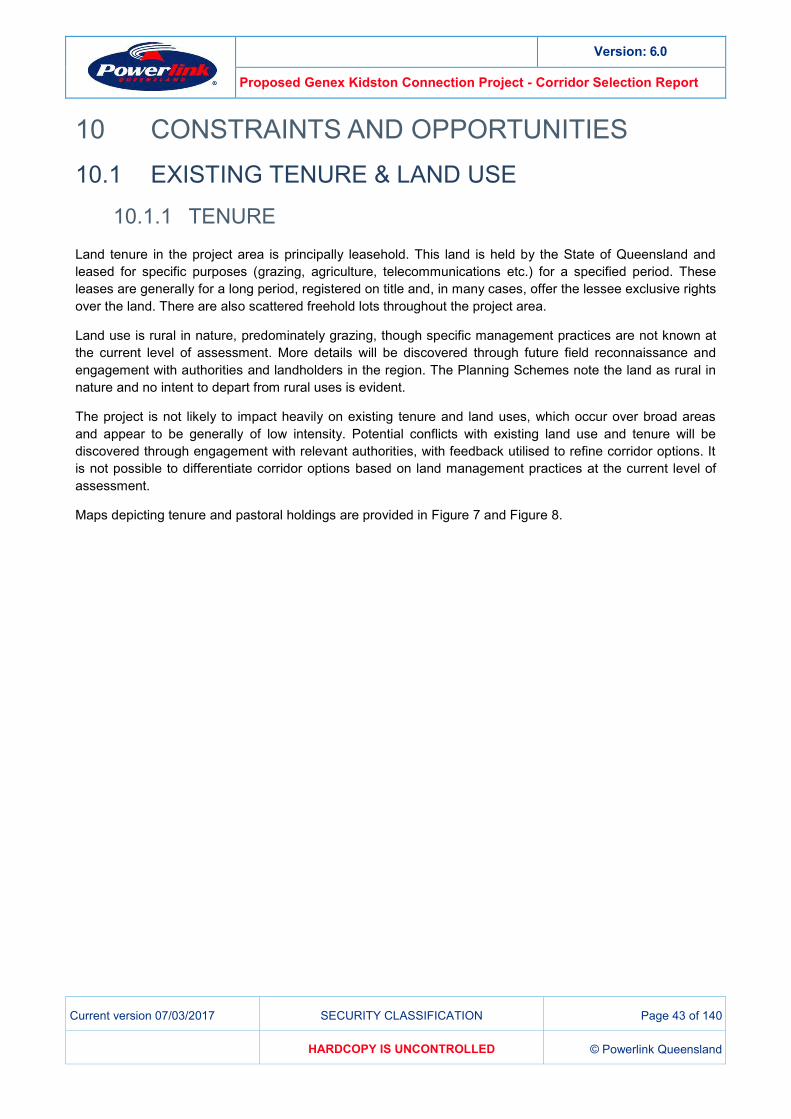
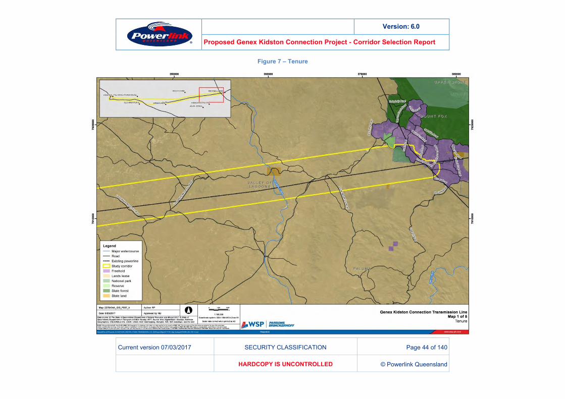
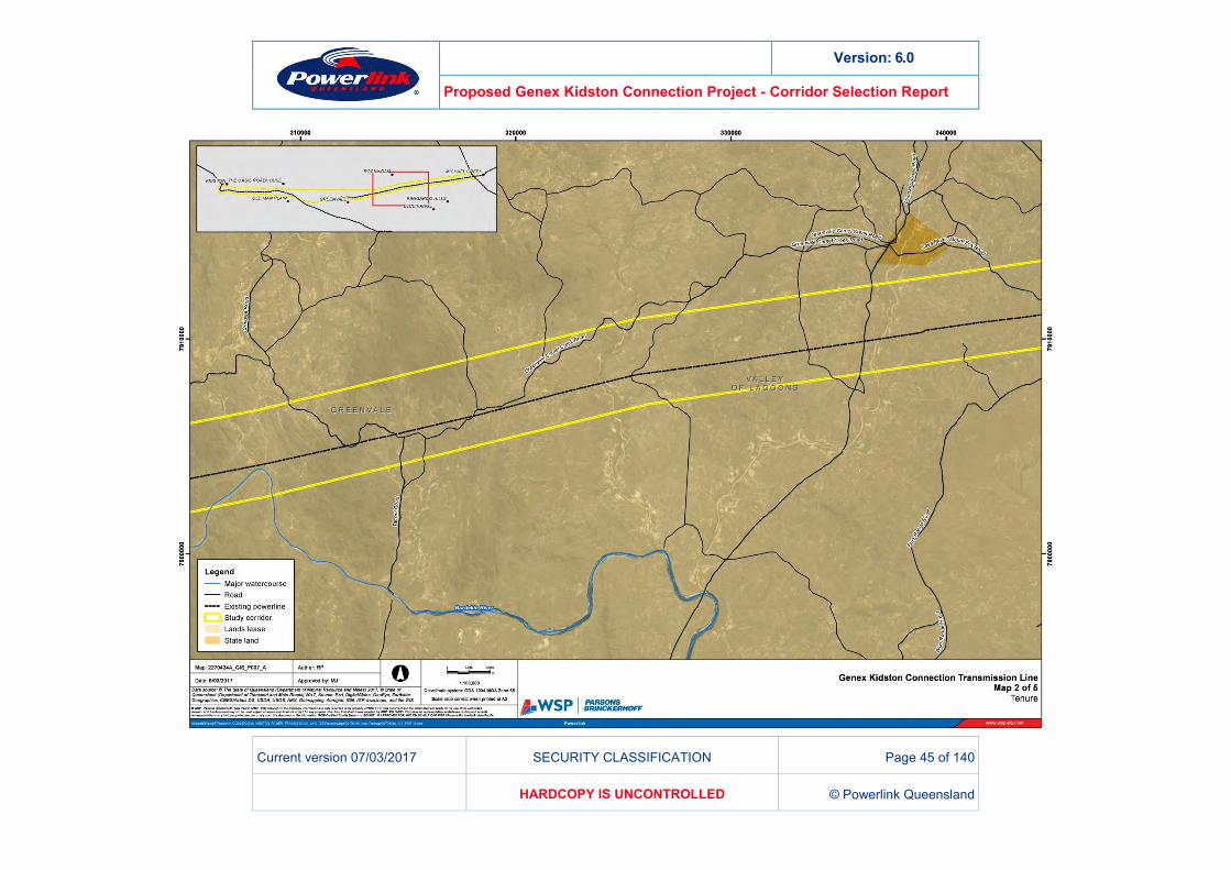
10 CONSTRAINTS AND OPPORTUNITIES EXISTING TENURE & LAND USE 10.1
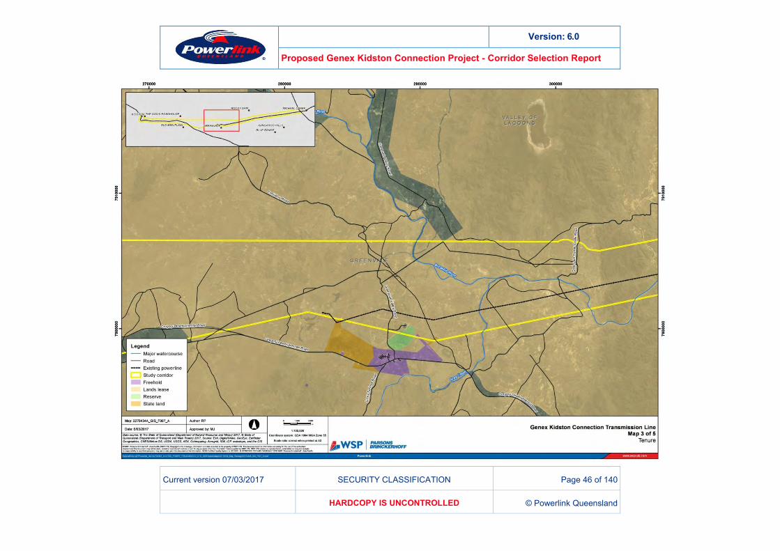
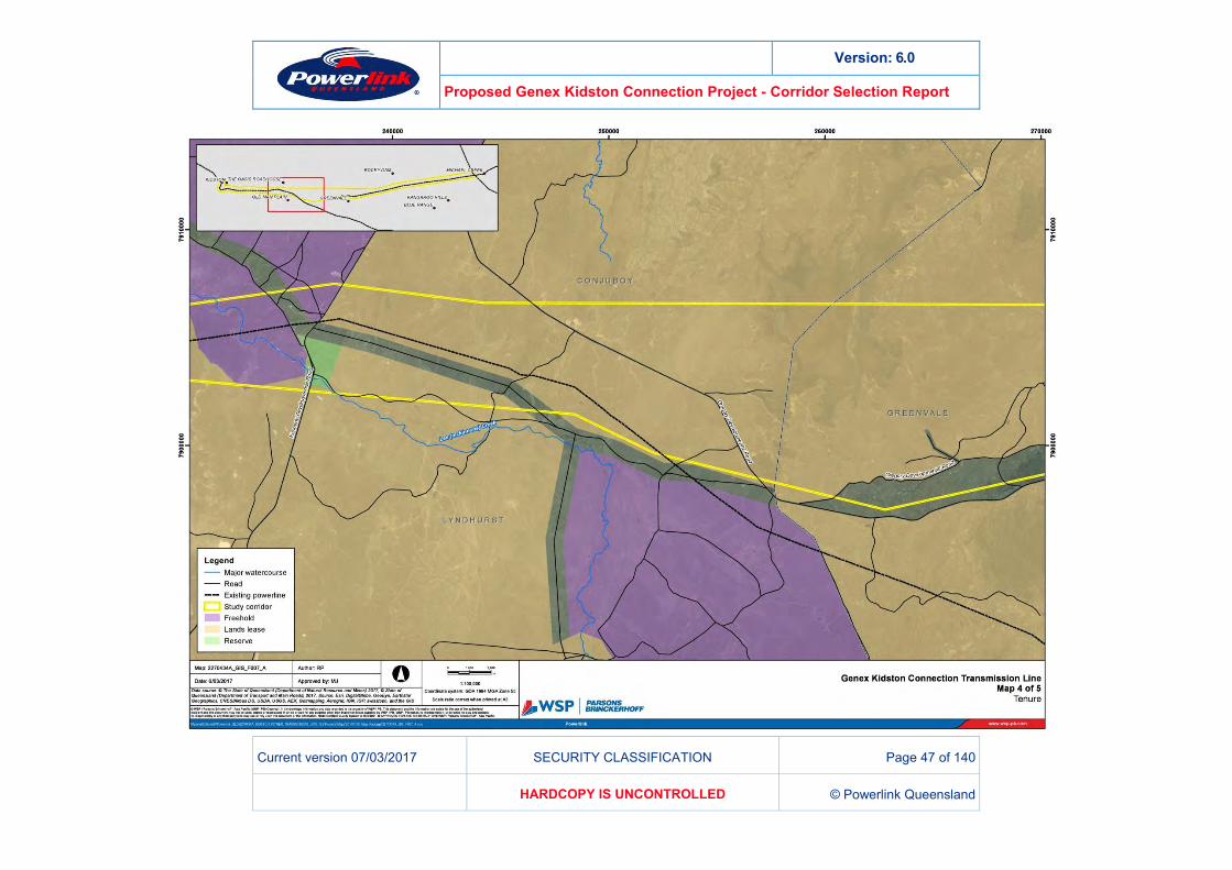
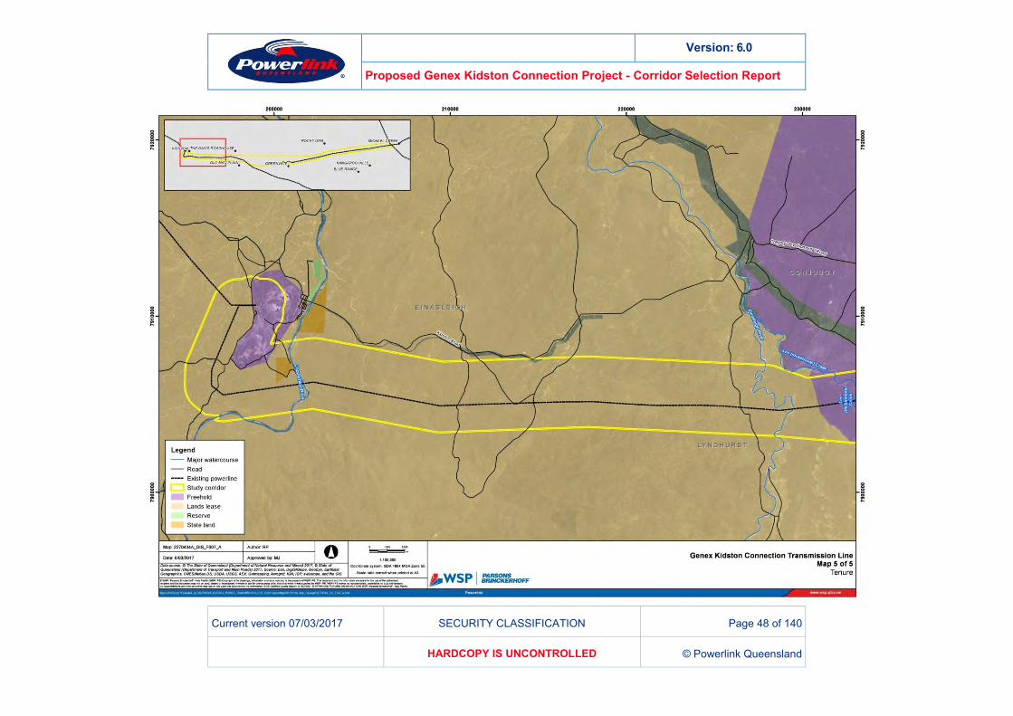
TENURE 10.1.1Land tenure in the project area is principally leasehold. This land is held by the State of Queensland and leased for specific purposes (grazing, agriculture, telecommunications etc.) for a specified period. These leases are generally for a long period, registered on title and, in many cases, offer the lessee exclusive rights over the land. There are also scattered freehold lots throughout the project area.
Land use is rural in nature, predominately grazing, though specific management practices are not known at the current level of assessment. More details will be discovered through future field reconnaissance and engagement with authorities and landholders in the region. The Planning Schemes note the land as rural in nature and no intent to depart from rural uses is evident.
The project is not likely to impact heavily on existing tenure and land uses, which occur over broad areas and appear to be generally of low intensity. Potential conflicts with existing land use and tenure will be discovered through engagement with relevant authorities, with feedback utilised to refine corridor options. It is not possible to differentiate corridor options based on land management practices at the current level of assessment.
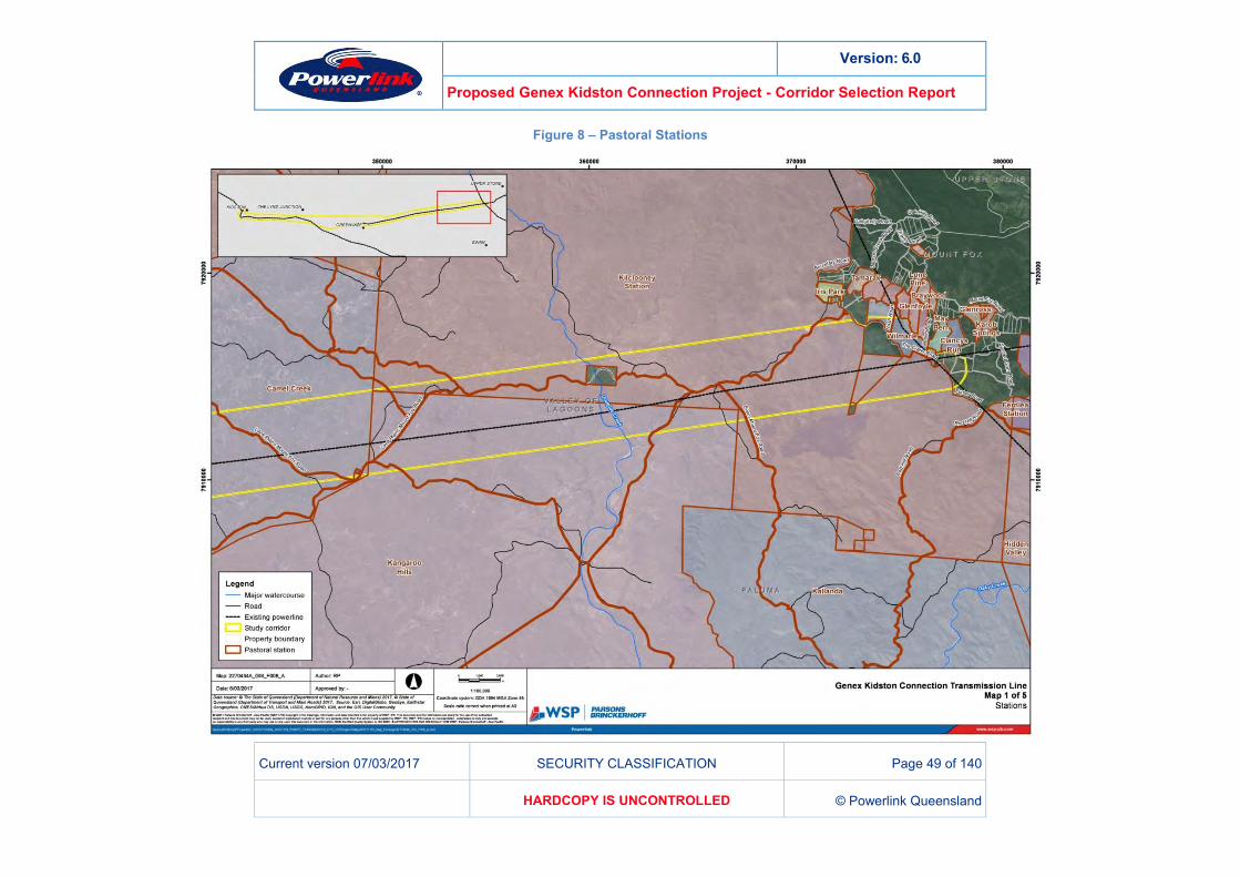
Maps depicting tenure and pastoral holdings are provided in Figure 7 and Figure 8.
Version: 6.0
Proposed Genex Kidston Connection Project - Corridor Selection Report
Current version 07/03/2017 SECURITY CLASSIFICATION Page 44 of 140
HARDCOPY IS UNCONTROLLED © Powerlink Queensland
Figure 7 – Tenure
Version: 6.0
Proposed Genex Kidston Connection Project - Corridor Selection Report
Current version 07/03/2017 SECURITY CLASSIFICATION Page 45 of 140
HARDCOPY IS UNCONTROLLED © Powerlink Queensland
Version: 6.0
Proposed Genex Kidston Connection Project - Corridor Selection Report
Current version 07/03/2017 SECURITY CLASSIFICATION Page 46 of 140
HARDCOPY IS UNCONTROLLED © Powerlink Queensland
Version: 6.0
Proposed Genex Kidston Connection Project - Corridor Selection Report
Current version 07/03/2017 SECURITY CLASSIFICATION Page 47 of 140
HARDCOPY IS UNCONTROLLED © Powerlink Queensland
Version: 6.0
Proposed Genex Kidston Connection Project - Corridor Selection Report
Current version 07/03/2017 SECURITY CLASSIFICATION Page 48 of 140
HARDCOPY IS UNCONTROLLED © Powerlink Queensland
Version: 6.0
Proposed Genex Kidston Connection Project - Corridor Selection Report
Current version 07/03/2017 SECURITY CLASSIFICATION Page 49 of 140
HARDCOPY IS UNCONTROLLED © Powerlink Queensland
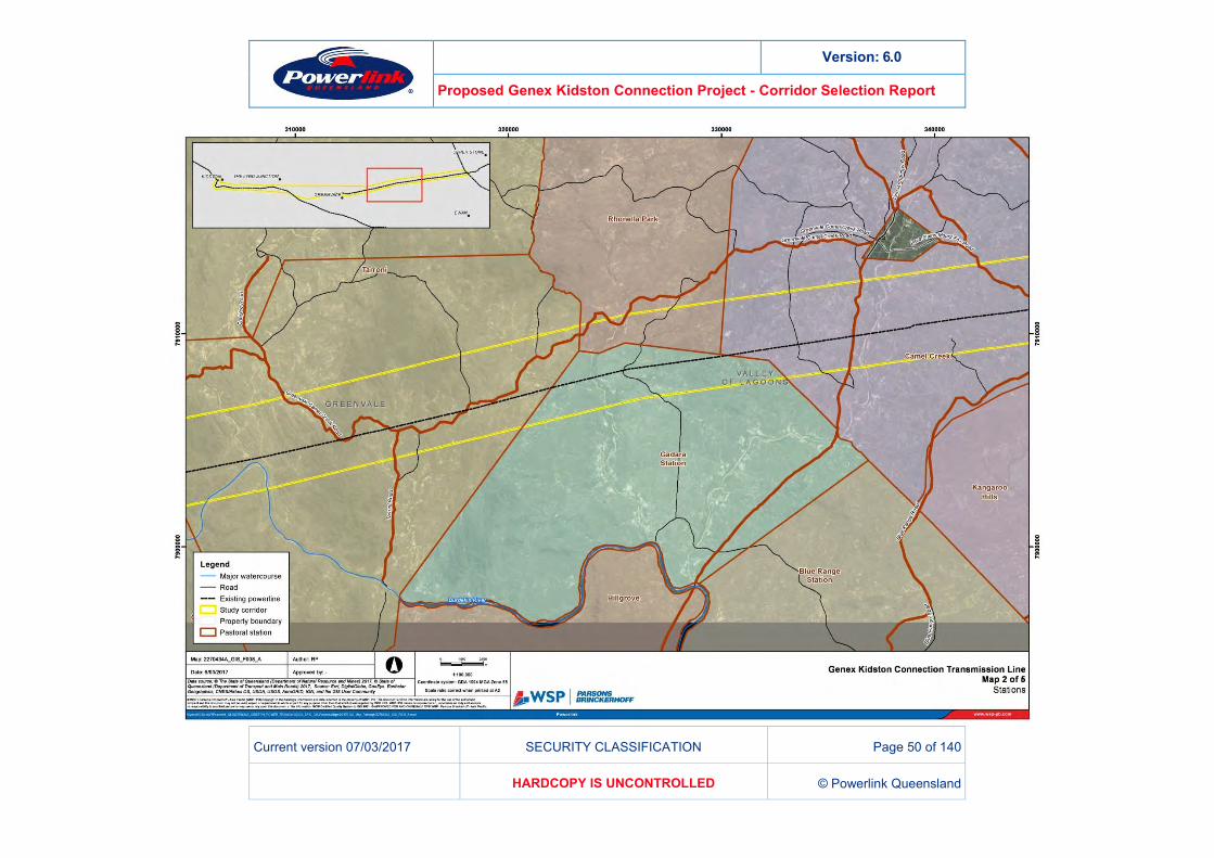
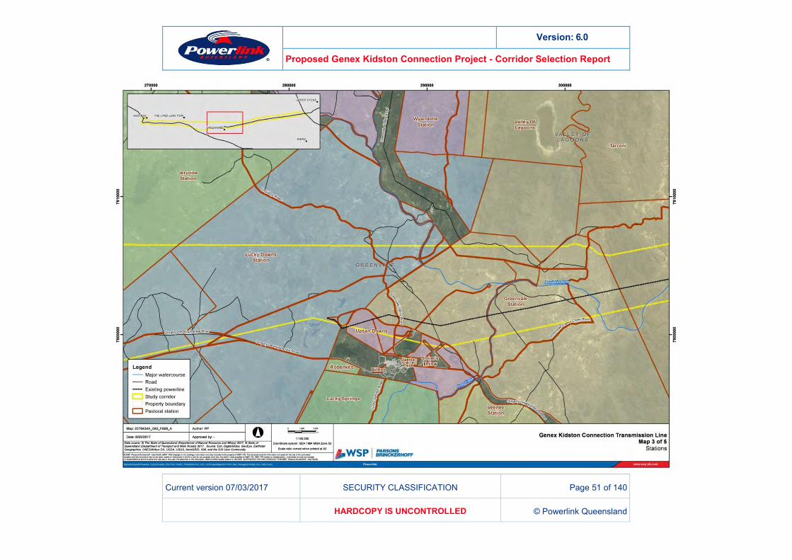
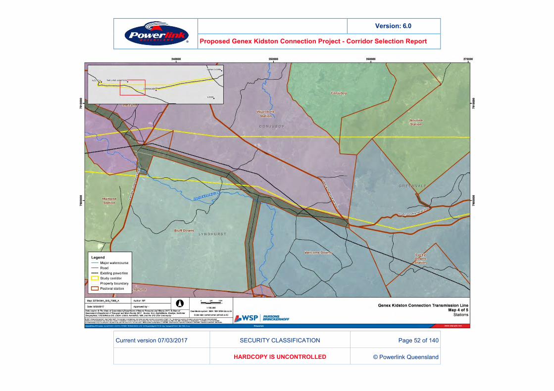
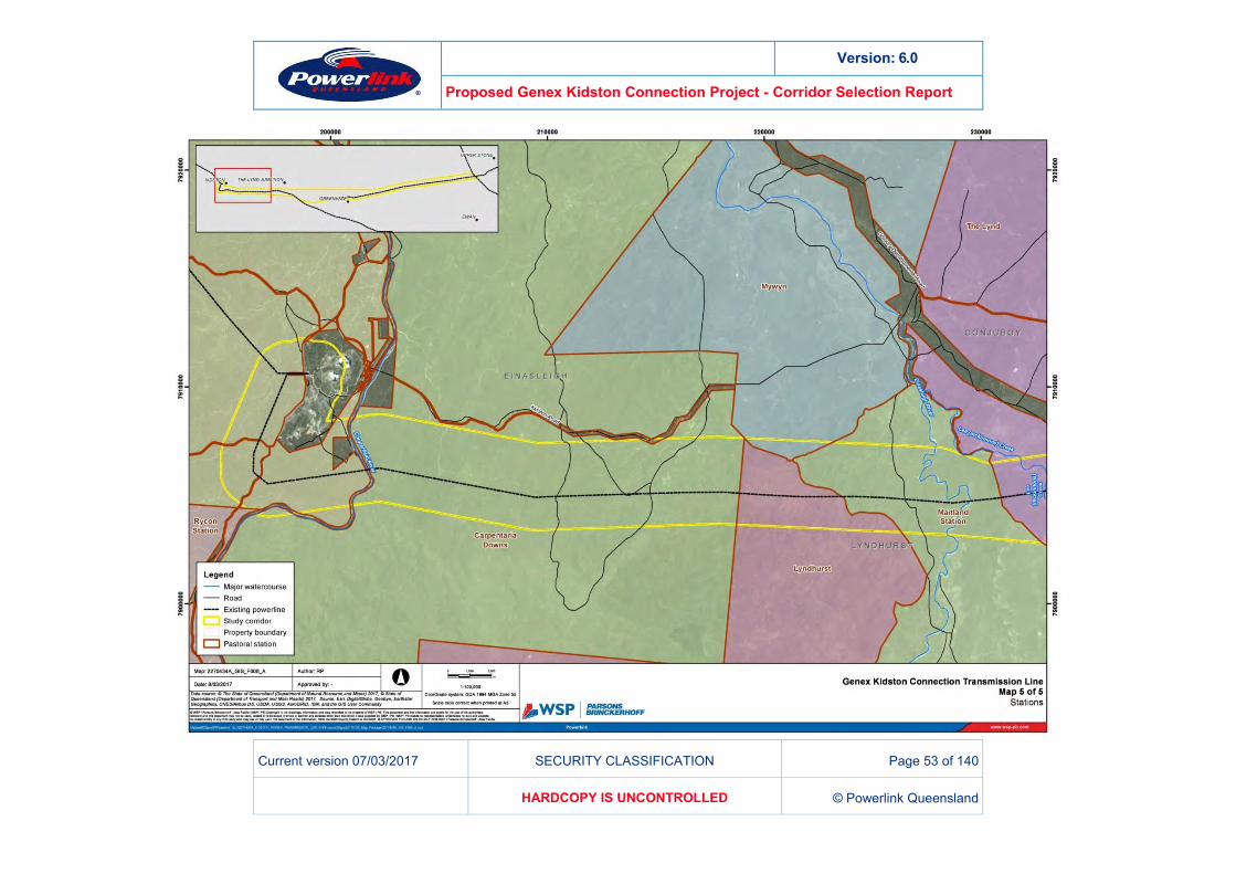
Figure 8 – Pastoral Stations
Version: 6.0
Proposed Genex Kidston Connection Project - Corridor Selection Report
Current version 07/03/2017 SECURITY CLASSIFICATION Page 50 of 140
HARDCOPY IS UNCONTROLLED © Powerlink Queensland
Version: 6.0
Proposed Genex Kidston Connection Project - Corridor Selection Report
Current version 07/03/2017 SECURITY CLASSIFICATION Page 51 of 140
HARDCOPY IS UNCONTROLLED © Powerlink Queensland
Version: 6.0
Proposed Genex Kidston Connection Project - Corridor Selection Report
Current version 07/03/2017 SECURITY CLASSIFICATION Page 52 of 140
HARDCOPY IS UNCONTROLLED © Powerlink Queensland
Version: 6.0
Proposed Genex Kidston Connection Project - Corridor Selection Report
Current version 07/03/2017 SECURITY CLASSIFICATION Page 53 of 140
HARDCOPY IS UNCONTROLLED © Powerlink Queensland
Version: 6.0
Proposed Genex Kidston Connection Project - Corridor Selection Report
Current version 07/03/2017 SECURITY CLASSIFICATION Page 54 of 140
HARDCOPY IS UNCONTROLLED © Powerlink Queensland
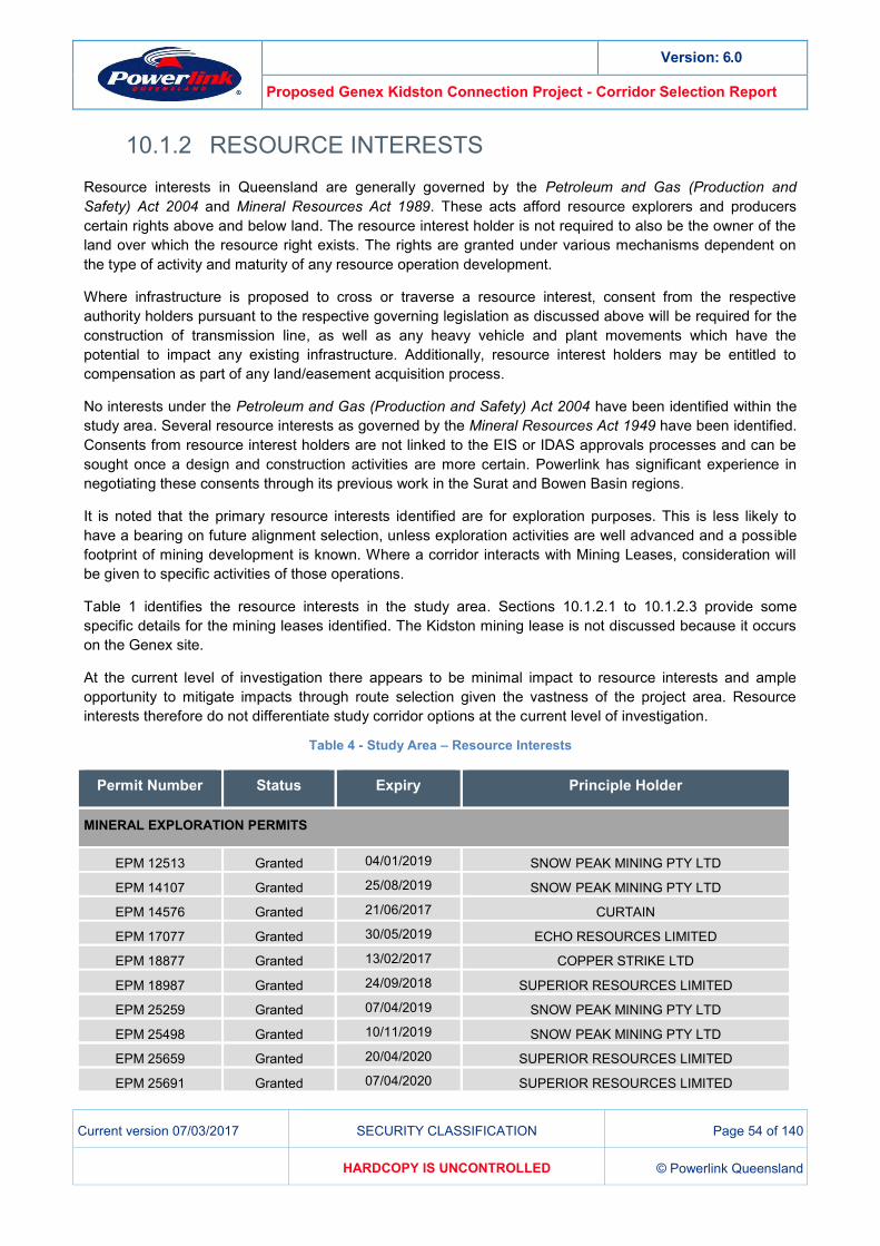
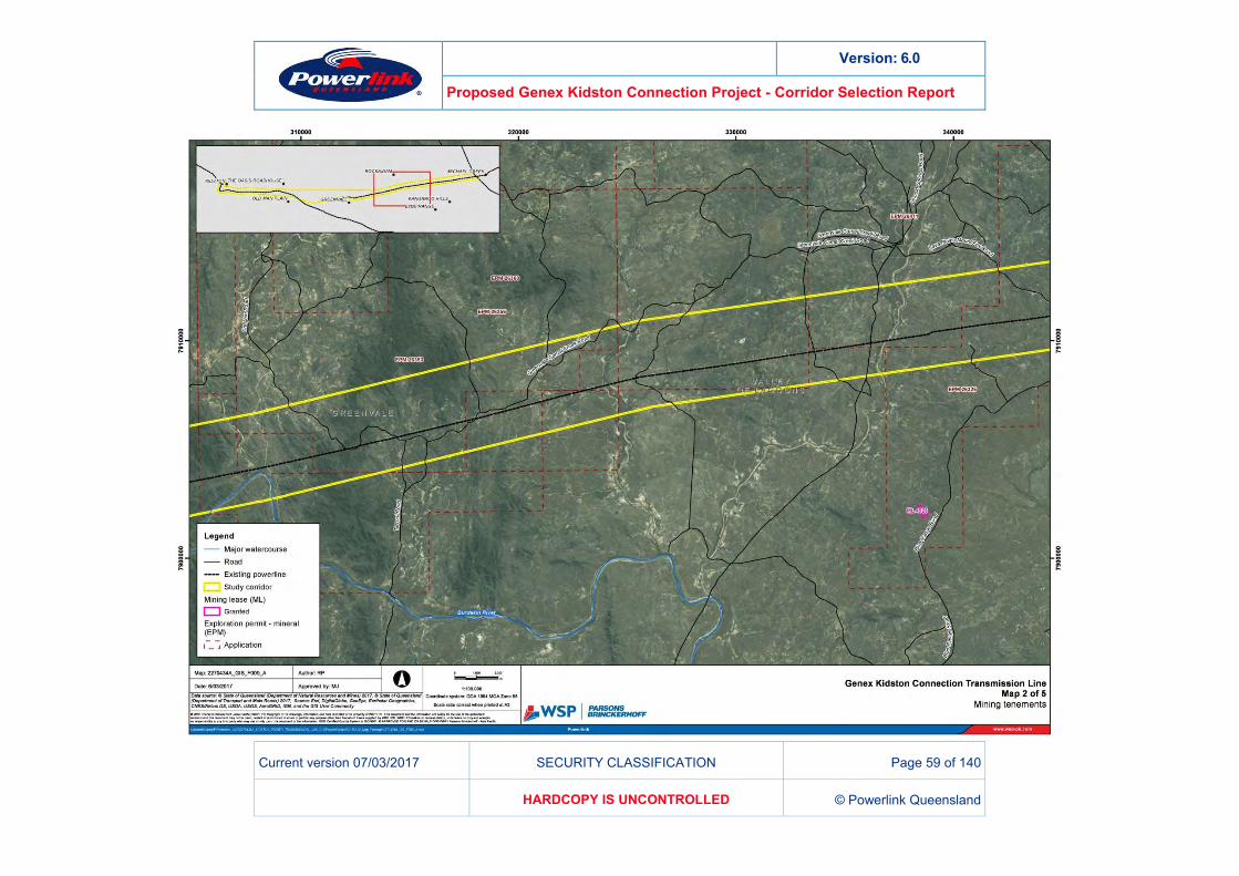
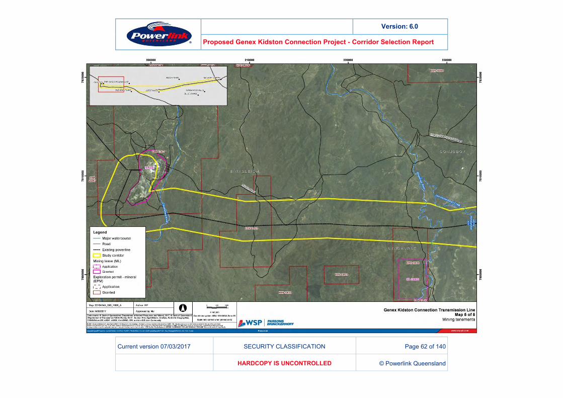
RESOURCE INTERESTS 10.1.2Resource interests in Queensland are generally governed by the Petroleum and Gas (Production and Safety) Act 2004 and Mineral Resources Act 1989. These acts afford resource explorers and producers certain rights above and below land. The resource interest holder is not required to also be the owner of the land over which the resource right exists. The rights are granted under various mechanisms dependent on the type of activity and maturity of any resource operation development.
Where infrastructure is proposed to cross or traverse a resource interest, consent from the respective authority holders pursuant to the respective governing legislation as discussed above will be required for the construction of transmission line, as well as any heavy vehicle and plant movements which have the potential to impact any existing infrastructure. Additionally, resource interest holders may be entitled to compensation as part of any land/easement acquisition process.
No interests under the Petroleum and Gas (Production and Safety) Act 2004 have been identified within the study area. Several resource interests as governed by the Mineral Resources Act 1949 have been identified. Consents from resource interest holders are not linked to the EIS or IDAS approvals processes and can be sought once a design and construction activities are more certain. Powerlink has significant experience in negotiating these consents through its previous work in the Surat and Bowen Basin regions.
It is noted that the primary resource interests identified are for exploration purposes. This is less likely to have a bearing on future alignment selection, unless exploration activities are well advanced and a possible footprint of mining development is known. Where a corridor interacts with Mining Leases, consideration will be given to specific activities of those operations.
Table 1 identifies the resource interests in the study area. Sections 10.1.2.1 to 10.1.2.3 provide some specific details for the mining leases identified. The Kidston mining lease is not discussed because it occurs on the Genex site.
At the current level of investigation there appears to be minimal impact to resource interests and ample opportunity to mitigate impacts through route selection given the vastness of the project area. Resource interests therefore do not differentiate study corridor options at the current level of investigation.
Table 4 - Study Area – Resource Interests
Permit Number Status Expiry Principle Holder
MINERAL EXPLORATION PERMITS
EPM 12513 Granted 04/01/2019 SNOW PEAK MINING PTY LTD
EPM 14107 Granted 25/08/2019 SNOW PEAK MINING PTY LTD
EPM 14576 Granted 21/06/2017 CURTAIN
EPM 17077 Granted 30/05/2019 ECHO RESOURCES LIMITED
EPM 18877 Granted 13/02/2017 COPPER STRIKE LTD
EPM 18987 Granted 24/09/2018 SUPERIOR RESOURCES LIMITED
EPM 25259 Granted 07/04/2019 SNOW PEAK MINING PTY LTD
EPM 25498 Granted 10/11/2019 SNOW PEAK MINING PTY LTD
EPM 25659 Granted 20/04/2020 SUPERIOR RESOURCES LIMITED
EPM 25691 Granted 07/04/2020 SUPERIOR RESOURCES LIMITED
Version: 6.0
Proposed Genex Kidston Connection Project - Corridor Selection Report
Current version 07/03/2017 SECURITY CLASSIFICATION Page 55 of 140
HARDCOPY IS UNCONTROLLED © Powerlink Queensland
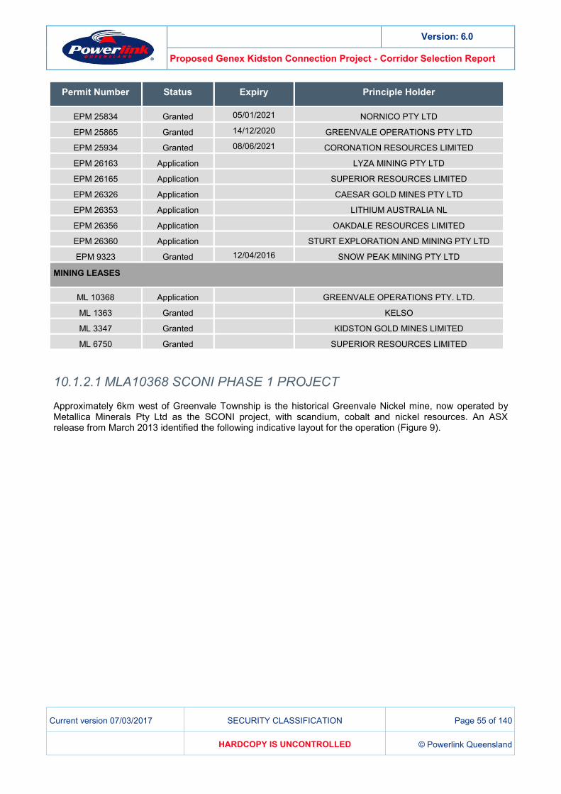
Permit Number Status Expiry Principle Holder
EPM 25834 Granted 05/01/2021 NORNICO PTY LTD
EPM 25865 Granted 14/12/2020 GREENVALE OPERATIONS PTY LTD
EPM 25934 Granted 08/06/2021 CORONATION RESOURCES LIMITED
EPM 26163 Application LYZA MINING PTY LTD
EPM 26165 Application SUPERIOR RESOURCES LIMITED
EPM 26326 Application CAESAR GOLD MINES PTY LTD
EPM 26353 Application LITHIUM AUSTRALIA NL
EPM 26356 Application OAKDALE RESOURCES LIMITED
EPM 26360 Application STURT EXPLORATION AND MINING PTY LTD
EPM 9323 Granted 12/04/2016 SNOW PEAK MINING PTY LTD
MINING LEASES
ML 10368 Application GREENVALE OPERATIONS PTY. LTD.
ML 1363 Granted KELSO
ML 3347 Granted KIDSTON GOLD MINES LIMITED
ML 6750 Granted SUPERIOR RESOURCES LIMITED
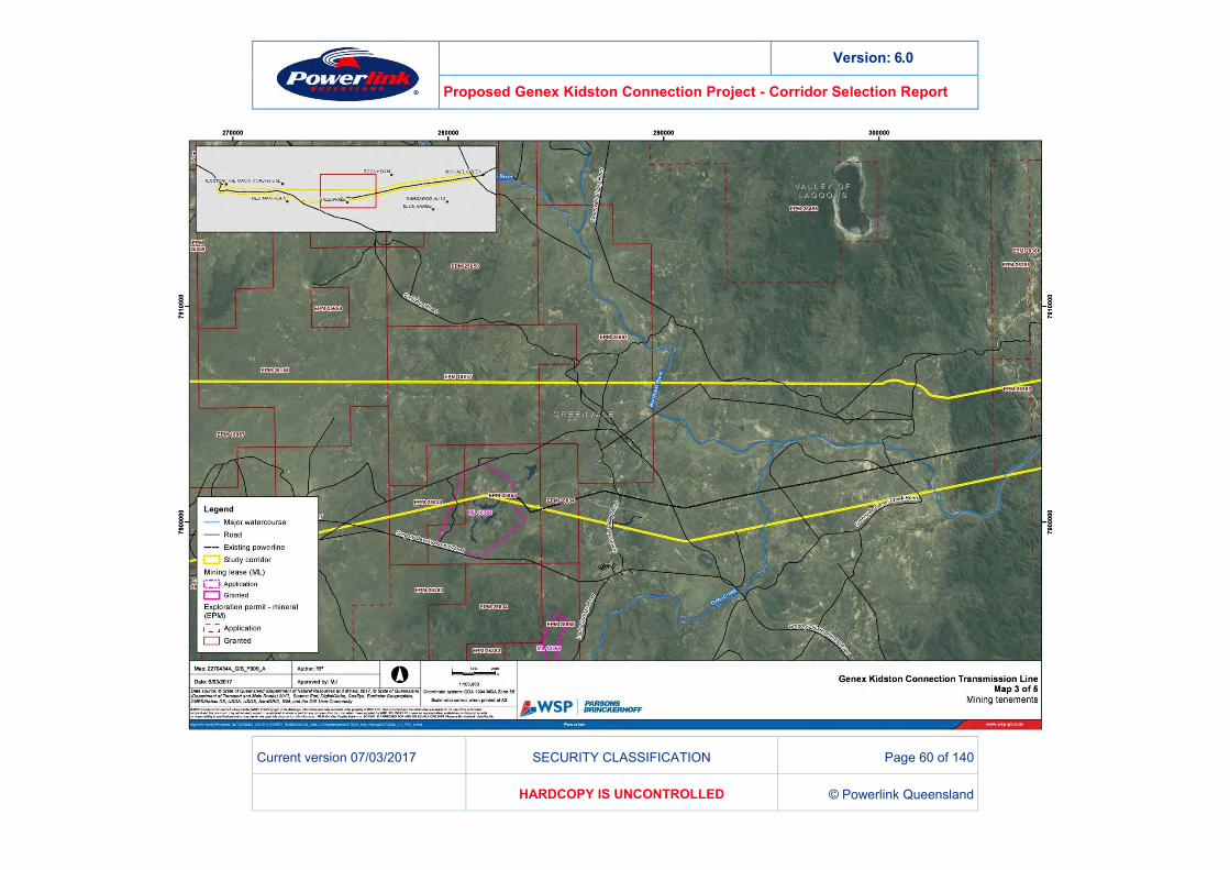
10.1.2.1 MLA10368 SCONI PHASE 1 PROJECT
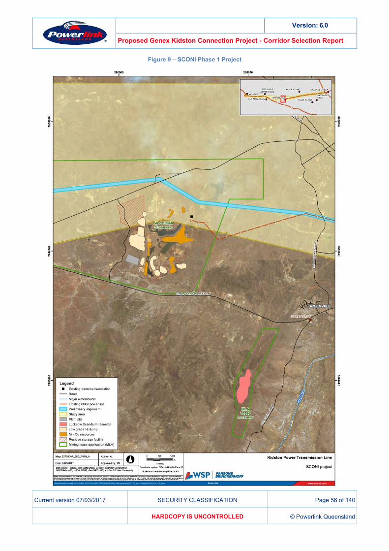
Approximately 6km west of Greenvale Township is the historical Greenvale Nickel mine, now operated by Metallica Minerals Pty Ltd as the SCONI project, with scandium, cobalt and nickel resources. An ASX release from March 2013 identified the following indicative layout for the operation (Figure 9).
Version: 6.0
Proposed Genex Kidston Connection Project - Corridor Selection Report
Current version 07/03/2017 SECURITY CLASSIFICATION Page 56 of 140
HARDCOPY IS UNCONTROLLED © Powerlink Queensland
Figure 9 – SCONI Phase 1 Project
Version: 6.0
Proposed Genex Kidston Connection Project - Corridor Selection Report
Current version 07/03/2017 SECURITY CLASSIFICATION Page 57 of 140
HARDCOPY IS UNCONTROLLED © Powerlink Queensland
The existing 66kV Ergon transmission line can be seen in Figure 9, representing the general path of study corridor option C. Metallica Minerals commenced the EIS process, lodging an initial advice statement and drafting a Terms of Reference consistent with the Environmental Protection Act 1994 in 2012 and 2013 respectively. The process has not been continued and is now registered as a withdrawn EIS process on the Department of Environment and Heritage Protection website, with the proponent voluntarily concluding the EIS process in 20153. There appears to be sufficient room between the resource areas to site a transmission line. Powerlink provided written project information to Metallica Minerals about its study corridor investigations in early 2017 and invited Metallica to participate in further discussions if desired.
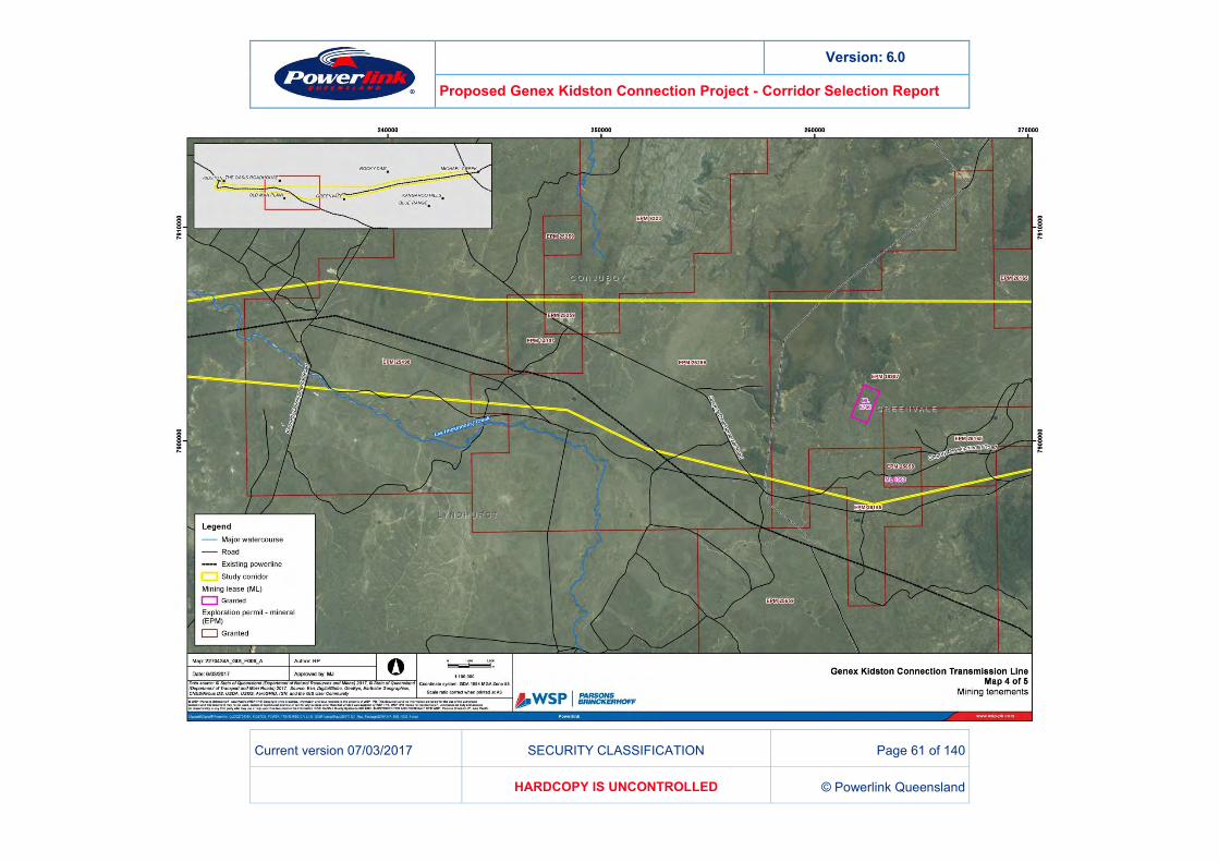
10.1.2.2 ML6750 ‘ONE MILE’
ML6750 is known as One Mile and based on exploratory drilling that contains low-grade copper, gold, zinc and silver values. Powerlink provided written project information to the One Mile about its study corridor investigations in early 2017 and invited them to participate in further discussions if desired.
10.1.2.3 ML1363 ‘LUCKY DIP’
ML1363 is an older permit, lodged in 1966. Few details are recorded against the permit and it is very small at only 2 hectares. No contact details could be identified for the permit. Given its diminutive size and the vastness of the surrounding project area, the permit is readily avoided if necessary.
3 https://www.ehp.qld.gov.au/management/impact-assessment/eis-processes/concluded.html

Version: 6.0
Proposed Genex Kidston Connection Project - Corridor Selection Report
Current version 07/03/2017 SECURITY CLASSIFICATION Page 58 of 140
HARDCOPY IS UNCONTROLLED © Powerlink Queensland
Figure 10 – Mining Interests
Version: 6.0
Proposed Genex Kidston Connection Project - Corridor Selection Report
Current version 07/03/2017 SECURITY CLASSIFICATION Page 59 of 140
HARDCOPY IS UNCONTROLLED © Powerlink Queensland
Version: 6.0
Proposed Genex Kidston Connection Project - Corridor Selection Report
Current version 07/03/2017 SECURITY CLASSIFICATION Page 60 of 140
HARDCOPY IS UNCONTROLLED © Powerlink Queensland
Version: 6.0
Proposed Genex Kidston Connection Project - Corridor Selection Report
Current version 07/03/2017 SECURITY CLASSIFICATION Page 61 of 140
HARDCOPY IS UNCONTROLLED © Powerlink Queensland
Version: 6.0
Proposed Genex Kidston Connection Project - Corridor Selection Report
Current version 07/03/2017 SECURITY CLASSIFICATION Page 62 of 140
HARDCOPY IS UNCONTROLLED © Powerlink Queensland
Version: 6.0
Proposed Genex Kidston Connection Project - Corridor Selection Report
Current version 07/03/2017 SECURITY CLASSIFICATION Page 63 of 140
HARDCOPY IS UNCONTROLLED © Powerlink Queensland
DEVELOPMENT APPLICATIONS 10.1.3A list of active development applications is published online by the Hinchinbrook Shire and Charters Towers Regional councils. The address of each of the development applications was searched to determine whether any are likely to occur in the project area. No applications were identified in or near to the study area.
Existing development applications are not published on the Etheridge Shire Council website. Etheridge Shire Council attended the stakeholder workshop in November 2016 and no conflicting developments were noted at that time or in subsequent engagement with Council.
ENCUMBERANCES 10.1.4Few easements exist in the vicinity of the project, limited to existing Powerlink and Ergon power lines. These easements do not pose a constraint to the project. A number of strata rights exist across the project area. The exact nature of the land uses associated with these rights is unknown, though they appear to occur over state lands and stock routes.
Engagement during the impact assessment stage will be required to determine the specific nature of the many strata rights observed. These encumbrances do not serve to differentiate study corridor options at the current level of assessment and are considered low risk to the overall development of the proposed Genex Kidston Connection transmission line.
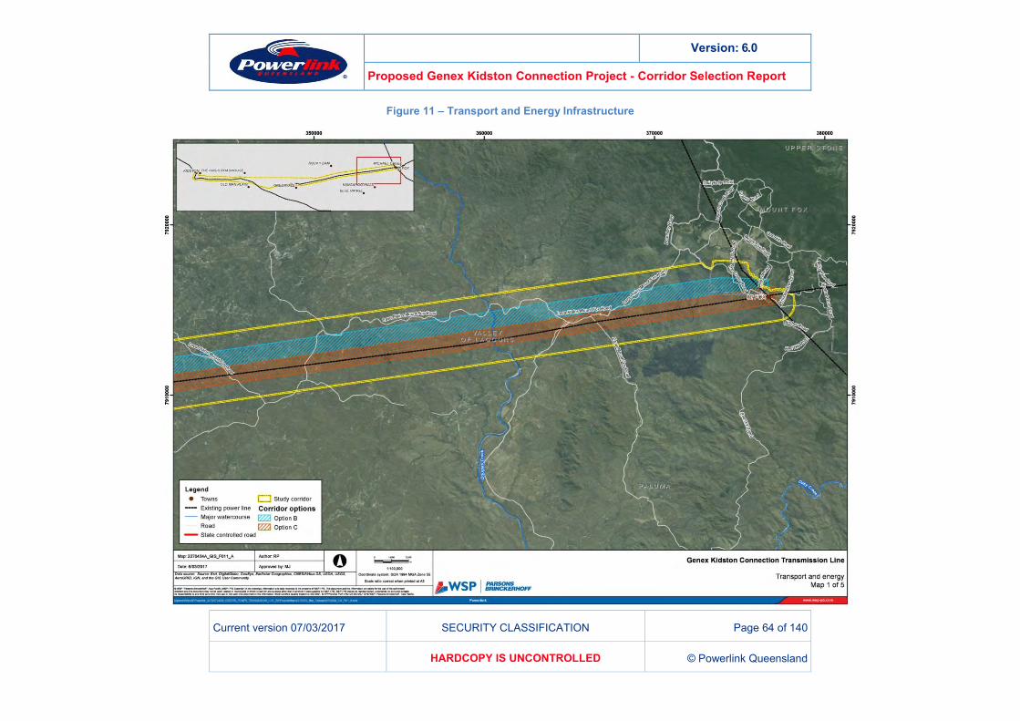
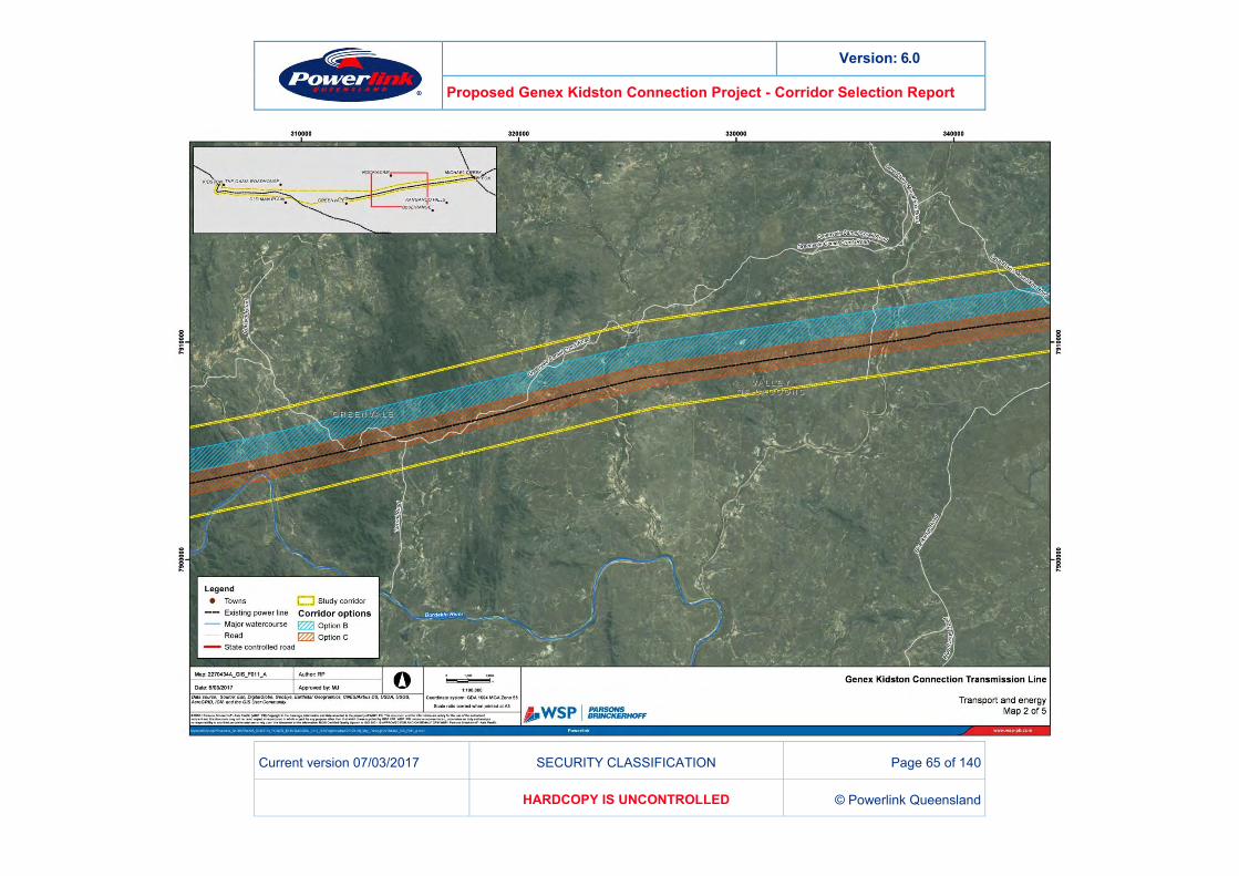
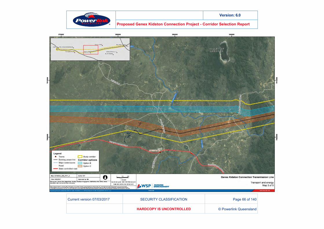
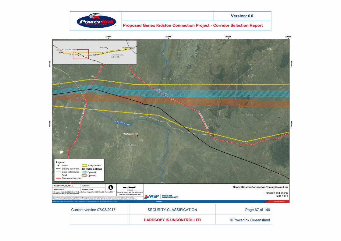
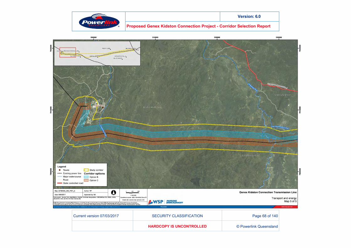
EXISTING INFRASTRUCTURE 10.1.5The project area contains little existing major infrastructure. Major roads include the Gregory and Kennedy Developmental Roads, which are intersected in the vicinity of Conjuboy. The proposed transmission line will be able to safely span over these roads.
Similarly the roads are unlikely to offer significant opportunity for co-location because they emanate from locations that offer insufficient access to the electrical transmission network and traverse through the populated areas in the region, such as Greenvale.
Existing Ergon transmission lines are noted, running parallel to the southernmost corridor option from Mt Fox to Greenvale and from an area around Conjuboy to Kidston. These lines operate at transmission voltages (66kV and 132kV). Existing cleared corridors for the Ergon lines may offer co-location opportunities for a new transmission corridor.
Co-location is beneficial in grouping together large, linear disturbances to the natural landscape. Fragmentation of vegetation is kept to a single area, minimising breaks in ecological connectivity in the area. Further benefits are derived in the potential for common access tracks, minimising both physical and social disturbance in the region.
A number of small private airstrips, as well as larger facilities at Greenvale and Kidston were noted during travel through the study area. All corridor options are likely to be proximal to airstrips and potential impacts to airstrips and aerial activities such as mustering will be an important consideration in subsequent impact assessments. Airstrips do not serve to differentiate corridor options at the current level of investigation.
Figure 11 identifies existing infrastructure throughout the project area.
Version: 6.0
Proposed Genex Kidston Connection Project - Corridor Selection Report
Current version 07/03/2017 SECURITY CLASSIFICATION Page 64 of 140
HARDCOPY IS UNCONTROLLED © Powerlink Queensland
Figure 11 – Transport and Energy Infrastructure
Version: 6.0
Proposed Genex Kidston Connection Project - Corridor Selection Report
Current version 07/03/2017 SECURITY CLASSIFICATION Page 65 of 140
HARDCOPY IS UNCONTROLLED © Powerlink Queensland
Version: 6.0
Proposed Genex Kidston Connection Project - Corridor Selection Report
Current version 07/03/2017 SECURITY CLASSIFICATION Page 66 of 140
HARDCOPY IS UNCONTROLLED © Powerlink Queensland
Version: 6.0
Proposed Genex Kidston Connection Project - Corridor Selection Report
Current version 07/03/2017 SECURITY CLASSIFICATION Page 67 of 140
HARDCOPY IS UNCONTROLLED © Powerlink Queensland
Version: 6.0
Proposed Genex Kidston Connection Project - Corridor Selection Report
Current version 07/03/2017 SECURITY CLASSIFICATION Page 68 of 140
HARDCOPY IS UNCONTROLLED © Powerlink Queensland
Version: 6.0
Proposed Genex Kidston Connection Project - Corridor Selection Report
Current version 07/03/2017 SECURITY CLASSIFICATION Page 69 of 140
HARDCOPY IS UNCONTROLLED © Powerlink Queensland
COMMUNITY BENEFITS 10.1.6The project potentially provides a range of benefits, including:
Supporting a major renewable energy project
Supporting both the Commonwealth Renewable Energy Target and State planning intent
Supporting the diversification of Queensland’s electricity generation mix
Creation of jobs during the construction period and for ongoing operation. The benefits of renewable energy projects are widespread and supported by legislation and policy. Employment generated during the construction period is likely to be of regional and local benefit. Because the proposed transmission line is approximately 200km long, it is likely the opportunity for project-related employment will occur across a broad geographic area and flow-on effects to small business will be equally wide spread.
Consultation will occur with relevant authorities regarding strategies to maximise community benefits should the project proceed to the next phase in the assessment process. All corridors provide similar community benefits.
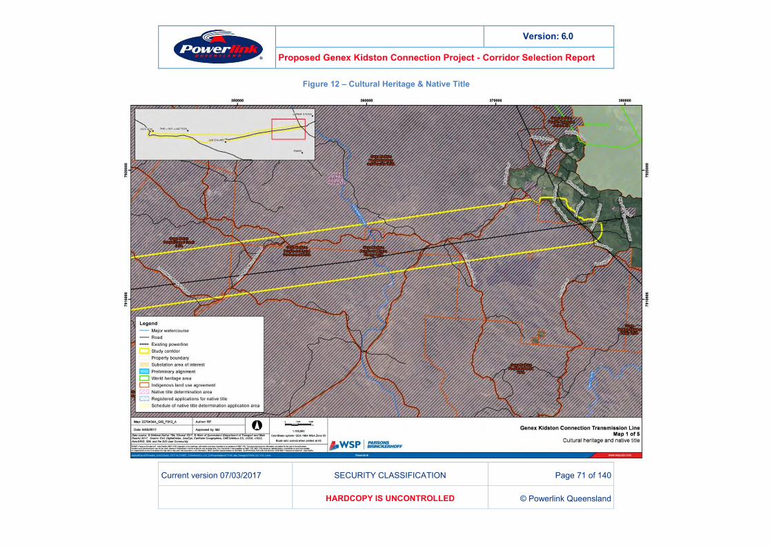
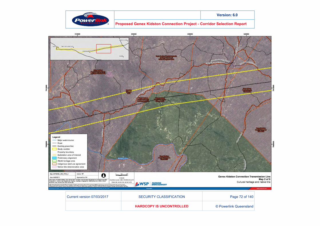
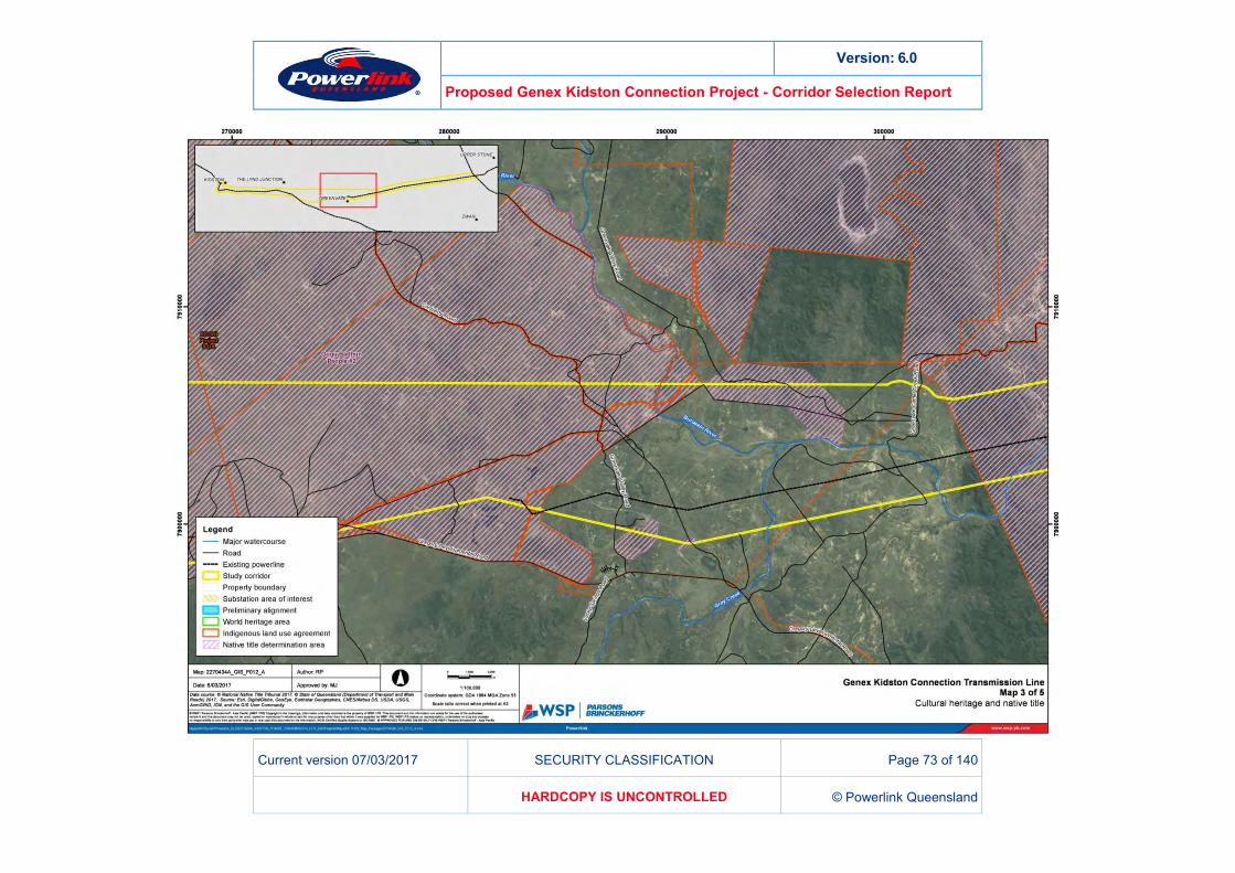
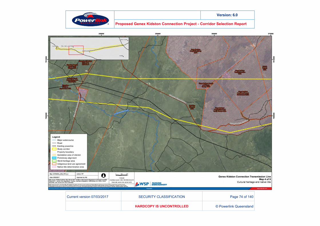
CULTURAL HERITAGE AND NATIVE TITLE 10.2
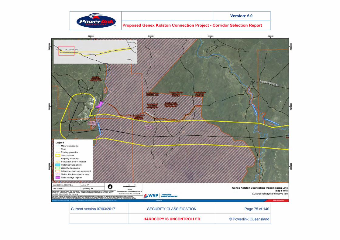
ABORIGINAL CULTURAL HERITAGE 10.2.1A search of the Department of Aboriginal and Torres Strait Islander Partnerships (DATSIP) database identifies three Aboriginal Parties whose Native Title determination areas are intersected by the study corridor.
Gugu Badhum People #3
Ewamian People #2
Ewamian People #3. Activities to be carried out during the clearing and construction phase for transmission lines are typically assessed as Category 5 of the Duty of Care guideline under the Aboriginal Cultural Heritage Act 2003 (ACHA) i.e. ground disturbing activities within a greenfield site. Powerlink’s strategy to meet its Duty of Care (s23 ACHA) is through the negotiation of a formal agreement or Cultural Heritage Management Plan (CHMP) with each of the relevant Aboriginal Parties and conducting its land clearing and construction activities in accordance with that agreements or CHMP. This typically includes a detailed cultural heritage survey. Powerlink has established processes for, and significant experience in the management of cultural heritage in transmission line development and working closely with Aboriginal parties. The processes of other development or constructing organisations are not discussed in this CSR.
Version: 6.0
Proposed Genex Kidston Connection Project - Corridor Selection Report
Current version 07/03/2017 SECURITY CLASSIFICATION Page 70 of 140
HARDCOPY IS UNCONTROLLED © Powerlink Queensland
EUROPEAN CULTURAL HERITAGE 10.2.2A search of the Queensland Heritage Register (DEHP) found one listing within proximity to the project. The Kidston State Battery and Township is classified as a State heritage place, however is not located within any of the three corridors. Historical heritage is therefore not an influencing factor in differentiating between possible corridors at the present level of assessment.
NATIVE TITLE 10.2.3The study area discussed in this report intersects the following Native Title determinations:
Gugu Badhum People #3
Ewamian People #2
Ewamian People #3.
The acquisition of an easement for the transmission line would be a ‘future act’ under the Native Title Act 1993 (C’th) and therefore requires that Native Title interests are addressed. To the extent that an easement acquisition and construction of infrastructure affects Native Title, Powerlink typically utilises section 24KA of the Native Title Act 1993 (C’th), which applies to facilities for services to the public, to validate the act and ‘supress’ Native Title over the easement for the ‘lifetime’ of the infrastructure.
On the basis that any proposed alignment within the project area would intersect the above determination areas, Native title compliance would not significantly differentiate between corridor options at present. Powerlink has established processes for, and significant experience in the management of Native Title in transmission line development. The processes of other development or constructing organisations are not discussed in this CSR.
Figure 12 depicts the Native Title determinations that intersect the project area.
Version: 6.0
Proposed Genex Kidston Connection Project - Corridor Selection Report
Current version 07/03/2017 SECURITY CLASSIFICATION Page 71 of 140
HARDCOPY IS UNCONTROLLED © Powerlink Queensland
Figure 12 – Cultural Heritage & Native Title
Version: 6.0
Proposed Genex Kidston Connection Project - Corridor Selection Report
Current version 07/03/2017 SECURITY CLASSIFICATION Page 72 of 140
HARDCOPY IS UNCONTROLLED © Powerlink Queensland
Version: 6.0
Proposed Genex Kidston Connection Project - Corridor Selection Report
Current version 07/03/2017 SECURITY CLASSIFICATION Page 73 of 140
HARDCOPY IS UNCONTROLLED © Powerlink Queensland
Version: 6.0
Proposed Genex Kidston Connection Project - Corridor Selection Report
Current version 07/03/2017 SECURITY CLASSIFICATION Page 74 of 140
HARDCOPY IS UNCONTROLLED © Powerlink Queensland
Version: 6.0
Proposed Genex Kidston Connection Project - Corridor Selection Report
Current version 07/03/2017 SECURITY CLASSIFICATION Page 75 of 140
HARDCOPY IS UNCONTROLLED © Powerlink Queensland
Version: 6.0
Proposed Genex Kidston Connection Project - Corridor Selection Report
Current version 07/03/2017 SECURITY CLASSIFICATION Page 76 of 140
HARDCOPY IS UNCONTROLLED © Powerlink Queensland
VISUAL AMENITY 10.3The transmission line has the potential to be visible from some residences, local government controlled roads, State controlled roads and Girringun National Park. The infrastructure has the potential to be visible from the following locations:
Local residences
Mt Fox Crater
Girringun National Park
The Crater Road
Lava Plains Mt Fox Road
Kangaroo Hills Road
Ewan Mt Fox Road
Valley of Lagoons Road
Craiglee Road
Conjuboy Road
Runs along Gregory Development Road
Kennedy Development Road
Unnamed Roads.
Visual amenity can be described as comprising two elements: a near field view, comprising the immediate and permanent amenity as visible from a fixed point (e.g. residences); and a far field view, comprising a more transient visual impact from a further distance (e.g. seen from a vehicle at a road crossing point). The severity of the impact depends on the proximity to the subject (in this instance the substation structure) and the amount of time that the structures are visible.
Visual amenity impacts will be assessed in detail in subsequent approval processes. Further engagement with potentially affected stakeholders and landholders would also occur, informed by the engagement undertaken as part of this CSR.
Visual exposure to the transmission line may be either avoidable or of minimal impact given the vast and expansive nature of the surrounding environment and the ability to carefully site transmission structures. Where exposure is not avoidable and a measurable impact is likely to occur, alternative mitigations will be investigated.
Powerlink has significant experience in the assessment, mitigation and management of visual amenity associated with transmission lines.
Version: 6.0
Proposed Genex Kidston Connection Project - Corridor Selection Report
Current version 07/03/2017 SECURITY CLASSIFICATION Page 77 of 140
HARDCOPY IS UNCONTROLLED © Powerlink Queensland
ELECTRIC AND MAGNETIC FIELDS (EMF) 10.4EMF readings at the edge of an easement for a 275kV transmission line are generally similar to those encountered by people in their daily activities at home or at work (e.g. a similar reading to what experienced using a typical electrical appliance or power tool). At about 100 metres from the line, the level of EMF is so small that it typically cannot be measured.
Powerlink has undertaken an EMF assessment for the proposed Genex Kidston Connection transmission line, taking into consideration the expected maximum capacity of the line based on both the hydro and solar generation facility in full operation. This technical assessment has confirmed that both the electric field and magnetic field strength for the proposed line will be below international guidelines.
AIR AND NOISE 10.5The nearest town to any of the draft corridor options is Greenvale (population 150), some 2km from the nearest corridor. The nearest population centre to the project area is Ingham (approximately 40km north-east of Mt Fox, population 4,706). With regard to air and noise, minimal to negligible impacts on population centres would be expected. Any impact to individual residences will require detailed consideration in any subsequent impact assessment phases, with only a very small number of properties proximal to all corridor options.
Additionally, during construction and operation of any transmission line, the environmental duty of care and compliance with the respective Environmental Protection Policies for Air and Noise management must be demonstrated. Measures contained within these policies would be applicable to any project and do not serve to differentiate corridors.
TRAFFIC 10.6Given the low-density nature of the surrounding environment, it is unlikely that major disruptions to the road network will be required. The requirement for road interruptions (or disturbance to other transport modes) and road improvements will be investigated during subsequent impact assessments and in consultation with relevant authorities.
Traffic impacts do not differentiate corridor options at the current level of assessment.
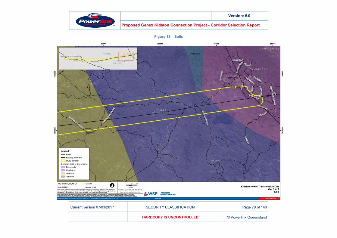
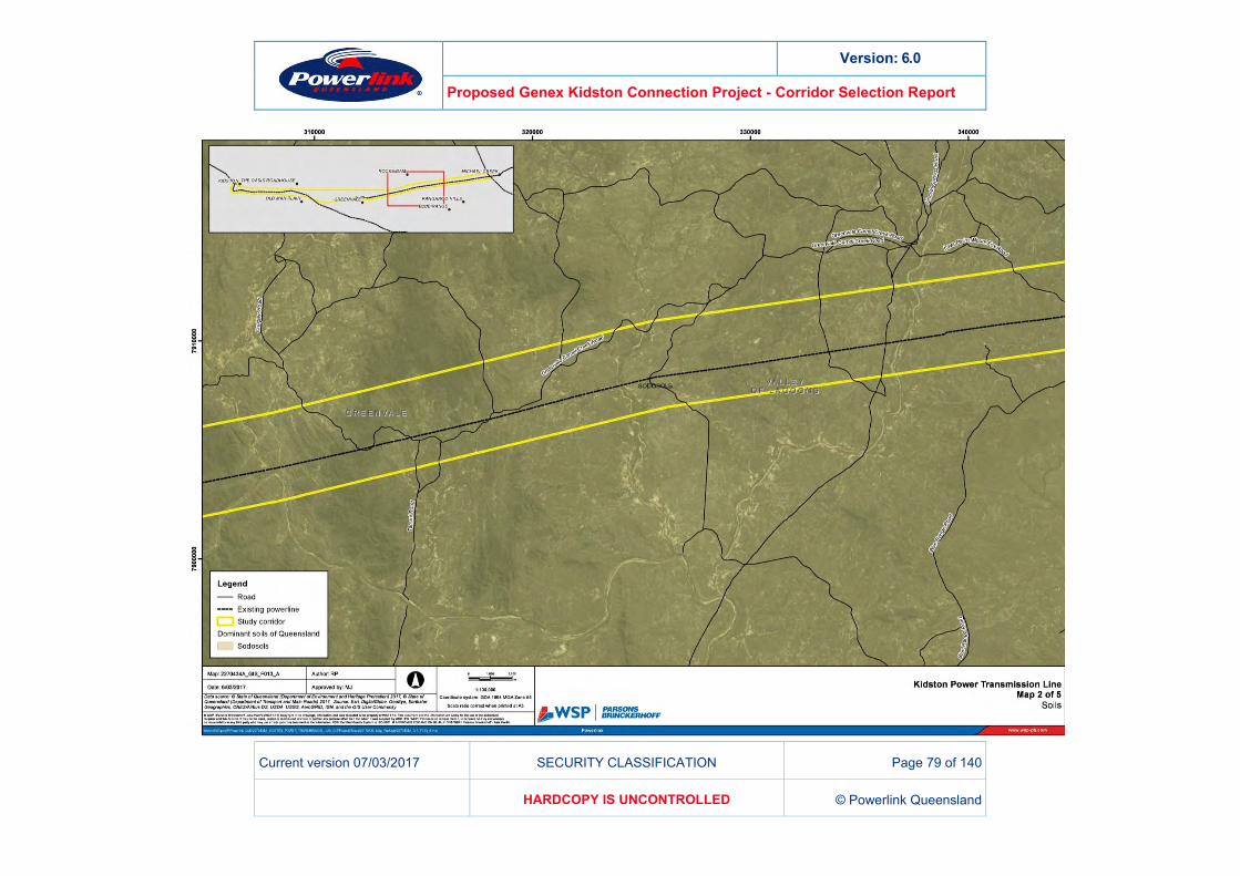
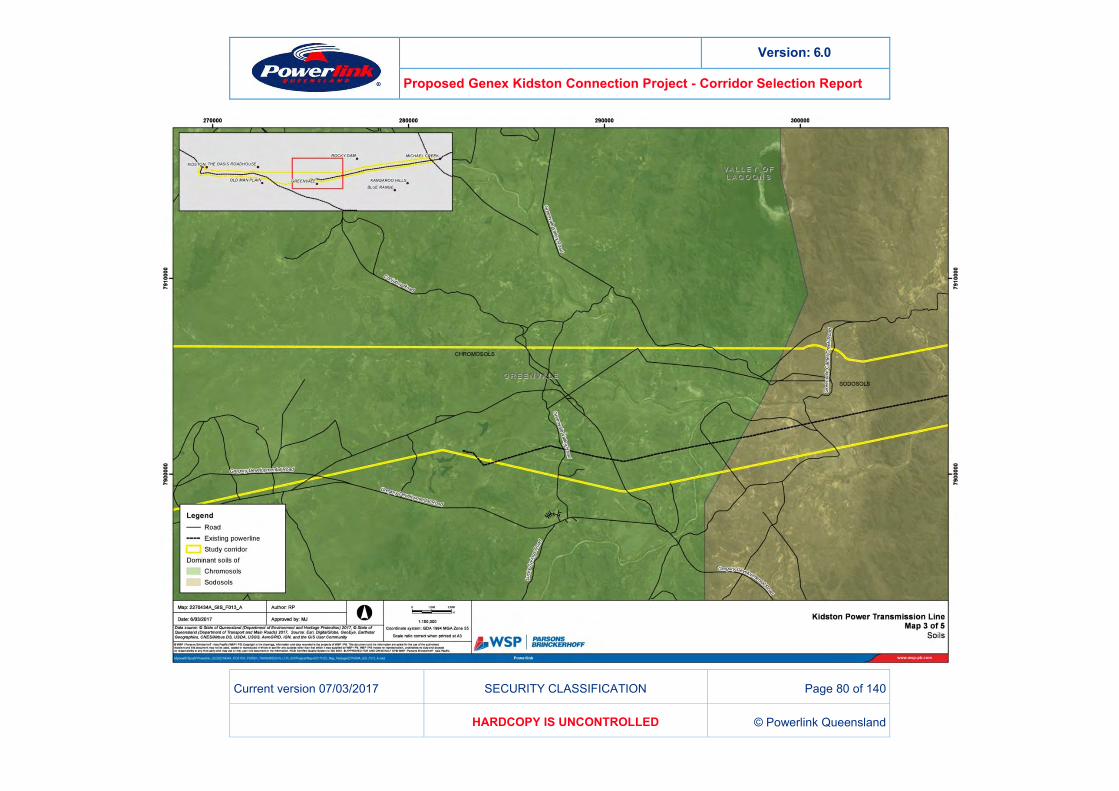
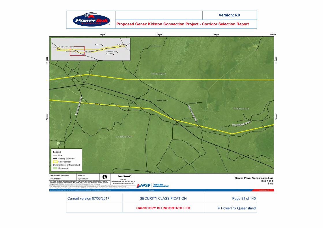
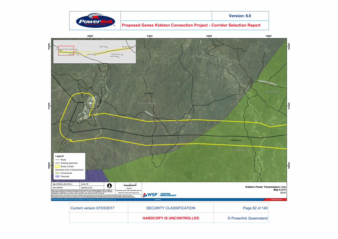
TOPOGRAPHY, GEOLOGY & SOILS 10.7The topography of the project area ranges from flat low-lying land to steep crossings of multiple ranges (including the Great Dividing Range). Elevation ranges from 400-800m AHD. All corridor options will be required to cross the Great Dividing Range (100km west of Mt Fox). Range crossings have been identified as a key constraint and guide the general direction of the corridor options to minimise associated constructability issues.
All draft corridor options traverse mainly chromosol and sodosol soil types (Figure 13). There is a very low probability of encountering acid sulphate soils (ASS) along any of the corridors as they mainly occur on coastal land that has elevations below 5m AHD. ASS are also required to be considered on land that is below 20m AHD. Both conditions are not relevant to this project.
A detailed assessment of acid sulphate soils and other highly reactive soils will be undertaken as part of future approvals processes and geotechnical investigations undertaken as part of the design phase.
Version: 6.0
Proposed Genex Kidston Connection Project - Corridor Selection Report
Current version 07/03/2017 SECURITY CLASSIFICATION Page 78 of 140
HARDCOPY IS UNCONTROLLED © Powerlink Queensland
Figure 13 – Soils
Version: 6.0
Proposed Genex Kidston Connection Project - Corridor Selection Report
Current version 07/03/2017 SECURITY CLASSIFICATION Page 79 of 140
HARDCOPY IS UNCONTROLLED © Powerlink Queensland
Version: 6.0
Proposed Genex Kidston Connection Project - Corridor Selection Report
Current version 07/03/2017 SECURITY CLASSIFICATION Page 80 of 140
HARDCOPY IS UNCONTROLLED © Powerlink Queensland
Version: 6.0
Proposed Genex Kidston Connection Project - Corridor Selection Report
Current version 07/03/2017 SECURITY CLASSIFICATION Page 81 of 140
HARDCOPY IS UNCONTROLLED © Powerlink Queensland
Version: 6.0
Proposed Genex Kidston Connection Project - Corridor Selection Report
Current version 07/03/2017 SECURITY CLASSIFICATION Page 82 of 140
HARDCOPY IS UNCONTROLLED © Powerlink Queensland
Version: 6.0
Proposed Genex Kidston Connection Project - Corridor Selection Report
Current version 07/03/2017 SECURITY CLASSIFICATION Page 83 of 140
HARDCOPY IS UNCONTROLLED © Powerlink Queensland
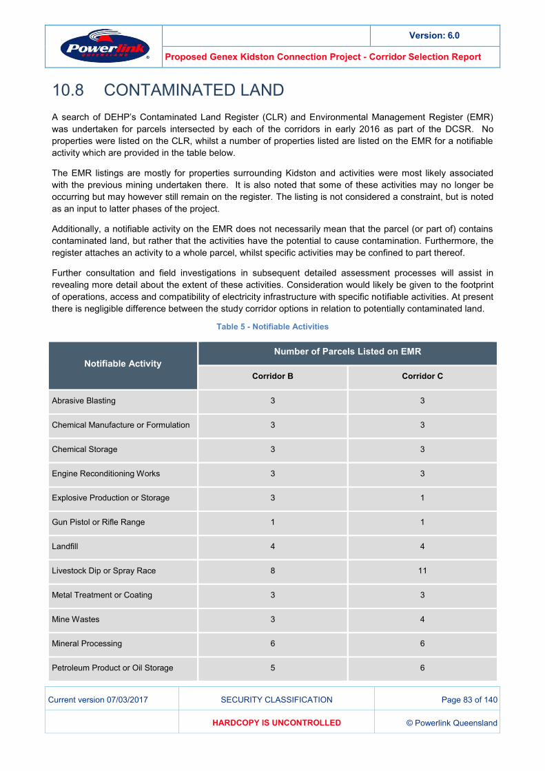
CONTAMINATED LAND 10.8A search of DEHP’s Contaminated Land Register (CLR) and Environmental Management Register (EMR) was undertaken for parcels intersected by each of the corridors in early 2016 as part of the DCSR. No properties were listed on the CLR, whilst a number of properties listed are listed on the EMR for a notifiable activity which are provided in the table below.
The EMR listings are mostly for properties surrounding Kidston and activities were most likely associated with the previous mining undertaken there. It is also noted that some of these activities may no longer be occurring but may however still remain on the register. The listing is not considered a constraint, but is noted as an input to latter phases of the project.
Additionally, a notifiable activity on the EMR does not necessarily mean that the parcel (or part of) contains contaminated land, but rather that the activities have the potential to cause contamination. Furthermore, the register attaches an activity to a whole parcel, whilst specific activities may be confined to part thereof.
Further consultation and field investigations in subsequent detailed assessment processes will assist in revealing more detail about the extent of these activities. Consideration would likely be given to the footprint of operations, access and compatibility of electricity infrastructure with specific notifiable activities. At present there is negligible difference between the study corridor options in relation to potentially contaminated land.
Table 5 - Notifiable Activities
Notifiable Activity Number of Parcels Listed on EMR
Corridor B Corridor C
Abrasive Blasting 3 3
Chemical Manufacture or Formulation 3 3
Chemical Storage 3 3
Engine Reconditioning Works 3 3
Explosive Production or Storage 3 1
Gun Pistol or Rifle Range 1 1
Landfill 4 4
Livestock Dip or Spray Race 8 11
Metal Treatment or Coating 3 3
Mine Wastes 3 4
Mineral Processing 6 6
Petroleum Product or Oil Storage 5 6
Version: 6.0
Proposed Genex Kidston Connection Project - Corridor Selection Report
Current version 07/03/2017 SECURITY CLASSIFICATION Page 84 of 140
HARDCOPY IS UNCONTROLLED © Powerlink Queensland
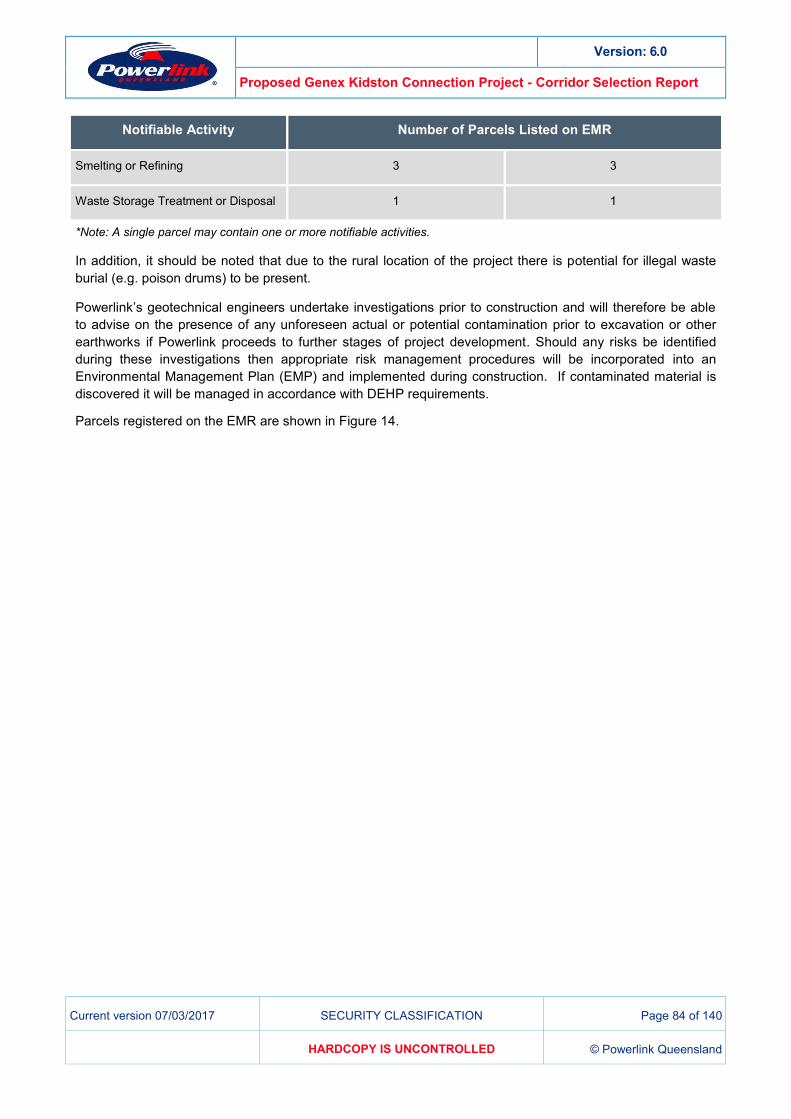
Notifiable Activity Number of Parcels Listed on EMR
Smelting or Refining 3 3
Waste Storage Treatment or Disposal 1 1
*Note: A single parcel may contain one or more notifiable activities.
In addition, it should be noted that due to the rural location of the project there is potential for illegal waste burial (e.g. poison drums) to be present.
Powerlink’s geotechnical engineers undertake investigations prior to construction and will therefore be able to advise on the presence of any unforeseen actual or potential contamination prior to excavation or other earthworks if Powerlink proceeds to further stages of project development. Should any risks be identified during these investigations then appropriate risk management procedures will be incorporated into an Environmental Management Plan (EMP) and implemented during construction. If contaminated material is discovered it will be managed in accordance with DEHP requirements.
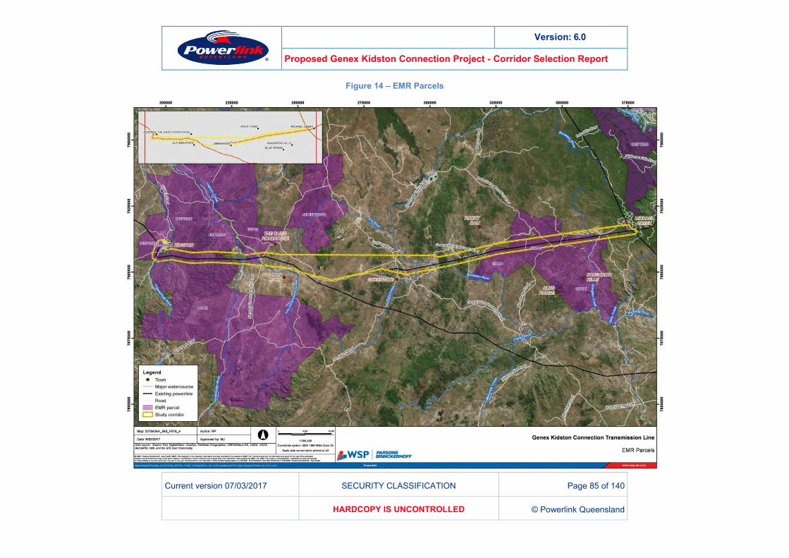
Parcels registered on the EMR are shown in Figure 14.
Version: 6.0
Proposed Genex Kidston Connection Project - Corridor Selection Report
Current version 07/03/2017 SECURITY CLASSIFICATION Page 85 of 140
HARDCOPY IS UNCONTROLLED © Powerlink Queensland
Figure 14 – EMR Parcels
Version: 6.0
Proposed Genex Kidston Connection Project - Corridor Selection Report
Current version 07/03/2017 SECURITY CLASSIFICATION Page 86 of 140
HARDCOPY IS UNCONTROLLED © Powerlink Queensland
UNEXPLODED ORDINANCE 10.9Unexploded ordinance mapping is noted in the far eastern extent of the study area at Mt Fox. The mapping notes the use of the area for training purposes post World War II.
Unexploded ordinance mapping is broad and will not differentiate corridor options at the current level of assessment. The potential presence of unexploded ordinance will be assessed in more detail in subsequent phases of the project, supported by field verification studies as required.
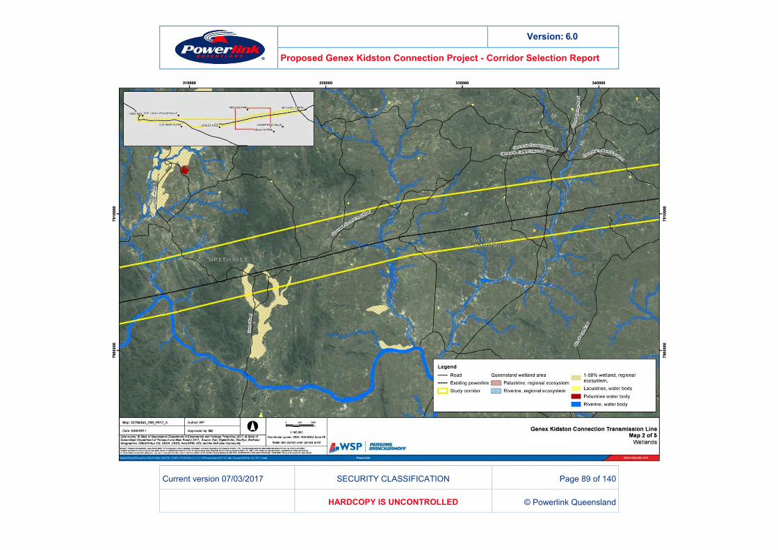
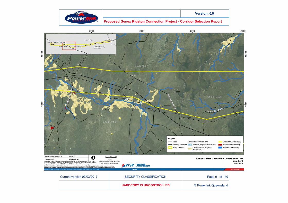
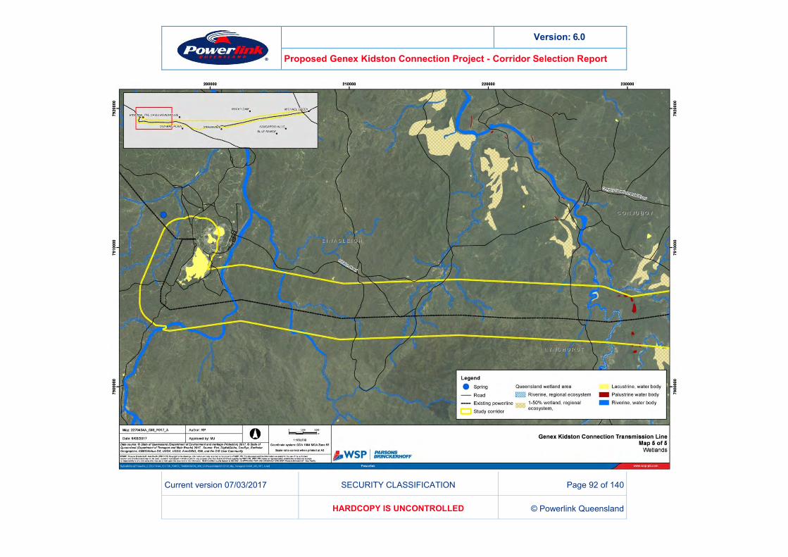
HYDROLOGY AND WATER QUALITY 10.10The topography within the project area ranges from flat low-lying land to steep crossings of multiple ranges (including the Great Dividing range) with elevation ranging from 400-800m AHD.
Each of the study corridor options cross the following major watercourses within the Burdekin River Basin:
Douglas Creek
Camel Creek
Burdekin River.
Each of the study corridor options cross the following major watercourses within the Gilbert River Basin:
Einasleigh River
Lee (McKinnons) Creek
Gray Creek (Option C only)
Copperfield River.
All study corridor options cross potential flood-prone areas west of the Gregory Development Road to Kidston. These areas are associated with the Copperfield and Einasleigh Rivers.
The likelihood of impacting hydrology and water quality characteristics of waterways within the project area is considered low as the infrastructure can usually be designed to span over constraints without the need to clear or disturb beds and banks. Alluvial soils on the banks and approaches to watercourses are generally of a loamy sand nature, prone to erosion and dispersion when disturbed.
Riparian vegetation performs a vital role in times of flood, reducing flow velocities, resisting channel erosion, anchoring streamside top soil, and helping to trap and retain water borne top soil washed from upstream. Through transmission line design and careful use of topography it is possible to locate the infrastructure on high points to elevate the lines over streamside vegetation and minimise clearing of riparian vegetation.
General ground disturbance associated with the construction of transmission structures and access tracks within the corridors has limited potential to result in sediment entering waterways. Where possible, existing access roads with established and maintained erosion and control measures (culverts and spoon drains) would be used, minimising vegetation clearing and disturbance to soil structures. Option C offers the greatest apparent advantage in this regard, reducing clearing requirement through co-location and allowing shared access via existing maintenance tracks.

Version: 6.0
Proposed Genex Kidston Connection Project - Corridor Selection Report
Current version 07/03/2017 SECURITY CLASSIFICATION Page 87 of 140
HARDCOPY IS UNCONTROLLED © Powerlink Queensland
The suitability of the existing tracks to enable construction machinery to access sites will be assessed through future field reconnaissance and there may be repair and minor upgrades of tracks and crossings required.
Further assessment of impacts and mitigation measures will be undertaken as part of future detailed impact assessments and would be subject to further engagement with the relevant landholders and stakeholders.

Version: 6.0
Proposed Genex Kidston Connection Project - Corridor Selection Report
Current version 07/03/2017 SECURITY CLASSIFICATION Page 88 of 140
HARDCOPY IS UNCONTROLLED © Powerlink Queensland
Figure 15 – Wetlands
Version: 6.0
Proposed Genex Kidston Connection Project - Corridor Selection Report
Current version 07/03/2017 SECURITY CLASSIFICATION Page 89 of 140
HARDCOPY IS UNCONTROLLED © Powerlink Queensland

Version: 6.0
Proposed Genex Kidston Connection Project - Corridor Selection Report
Current version 07/03/2017 SECURITY CLASSIFICATION Page 90 of 140
HARDCOPY IS UNCONTROLLED © Powerlink Queensland
Version: 6.0
Proposed Genex Kidston Connection Project - Corridor Selection Report
Current version 07/03/2017 SECURITY CLASSIFICATION Page 91 of 140
HARDCOPY IS UNCONTROLLED © Powerlink Queensland
Version: 6.0
Proposed Genex Kidston Connection Project - Corridor Selection Report
Current version 07/03/2017 SECURITY CLASSIFICATION Page 92 of 140
HARDCOPY IS UNCONTROLLED © Powerlink Queensland