Embed Size (px)
Citation preview
7 Duke Street Cromarty Ross-shire IV11 8YH Tel / Fax: 01381 600491
Mobile: 07834 693378 Email: [email protected] Web: www.hi-arch.co.uk
VAT No. 838 7358 80 Registered in Scotland no. 262144 Registered Office: 10 Knockbreck Street, Tain, Ross-shire IV19 1BJ
Highland Archaeology Services Ltd Bringing the Past and Future Together
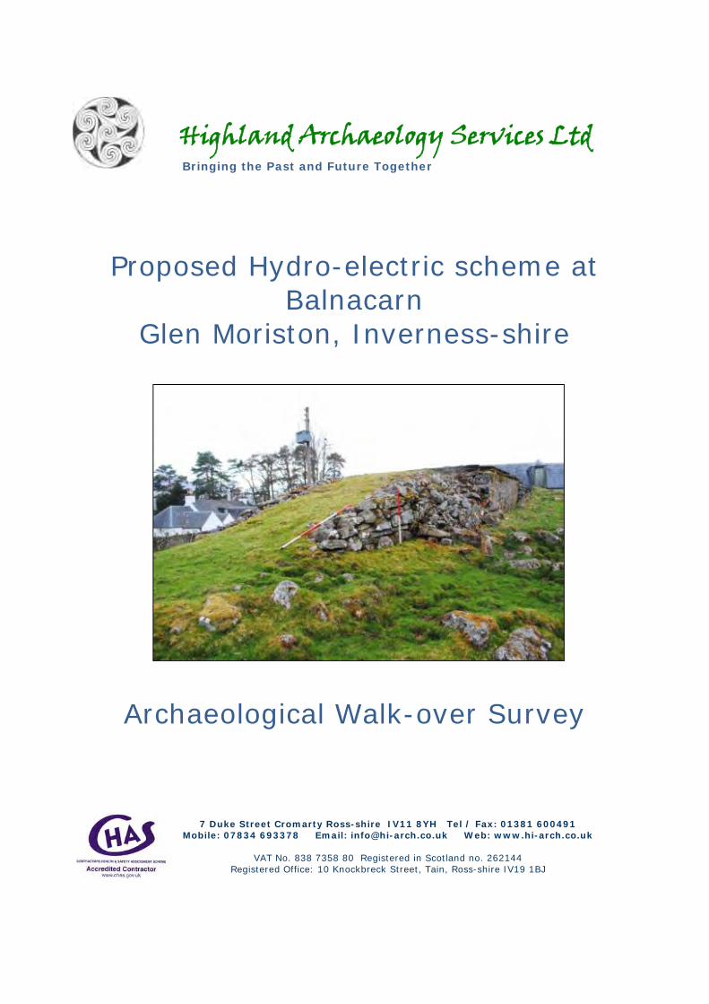
Proposed Hydro-electric scheme at Balnacarn
Glen Moriston, Inverness-shire
Archaeological Walk-over Survey

Balnacarn, Glen Moriston Walk-over Survey May 2010
1
Proposed Hydro-electric scheme at Balnacarn
Glen Moriston, Inverness-shire
Archaeological Walk-over Survey
Report No. HAS100601
Site Code HAS-GMN10
Client Dulas Hydro
Location (NGR) NH 2737 1318
Planning Ref N/A
Date/ revision 19/05/2010
Authors John Wood Mary Peteranna Lynn Fraser
Summary An archaeological walk-over survey was carried out on May 10, 2010 in Glen Moriston on behalf of Dulas Hydro Generation Ltd to assess the nature and extent of any archaeology along the proposed pipeline routes for two hydro-electric schemes. Six sites of archaeological interest were recorded within close proximity to the Balnacarn pipeline route.

Balnacarn, Glen Moriston Walk-over Survey May 2010
2
Contents Policy and project background ............................................................................................................................ 2 Site location, topography and geology ................................................................................................................ 3 Archaeological and historical background .......................................................................................................... 6 Methodology ....................................................................................................................................................... 6
Desk-based assessment .................................................................................................................................... 6 Survey .............................................................................................................................................................. 7
Results ................................................................................................................................................................. 8 Desk-based assessment .................................................................................................................................... 8 Walkover Survey ........................................................................................................................................... 10
Recommendations and conclusions ................................................................................................................... 15 References ......................................................................................................................................................... 16 Appendix 1 Index of Archaeological Features ............................................................................................. 21 Appendix 2 Index of Photographs ................................................................................................................ 23
Illustrations Figure 1 Survey location .................................................................................................................................... 4 Figure 2 Balnacarn proposed hydro scheme ....................................................................................................... 5 Figure 3 First edition 6-inch OS map showing Balnacarn (1871) at the proposed pipeline entry point ............ 7 Figure 4 Locations of archaeological sites recorded by walk-over survey......................................................... 9 Figure 5 Sketch - S facing elevation of sluice (Site 1) ..................................................................................... 10 Figure 6 Plan 5: Overall plan of situation of dam and lade (Site 1) ................................................................. 11 Figure 7 North-facing profile of dam inner wall face (Site 1) .......................................................................... 12 Figure 8 Site 1 Mill dam and lade (Site 1) .................................................................................................... 13 Figure 9 Sketch plans: Site 3 (left); Site 4 (right) ............................................................................................ 14 Plate 1 Dam and lade (Site 1) ............................................................................................................................ 17 Plate 2 Site 1: Sluice and gate (top), remains of above-ground lade (bottom) ................................................. 18 Plate 3 Remains of bothy / fold (Site 3) ........................................................................................................... 19 Plate 4 Drystone building (Site 4) .................................................................................................................... 19 Plate 5 Cairn (Site 5) ........................................................................................................................................ 20 Plate 6 Ramp (Site 6) ........................................................................................................................................ 20
Acknowledgements Fieldwork was carried out by Lynn Fraser and Mary Peteranna. The report was edited by John Wood. Fieldwork mapping is reproduced by permission of Landmark Information Group, RoCAS license #LIG1044. Background mapping has been reproduced by permission of the Ordnance Survey under HAS license 100043217. The site condition codes have been adopted from Martin Wildgoose (AALS) with permission.
Policy and project background

Balnacarn, Glen Moriston Walk-over Survey May 2010
3
The purpose of the archaeological walkover survey was to identify and record the location and nature of any previously unrecorded archaeological features visible on the surface, whilst assessing any potential adverse impacts prior to development of the sites. The Electricity Act 19891, as amended by the Utilities Act 20002, requires Electricity companies to preserve ‘amenity’ including the cultural heritage, and to minimise impacts of new infrastructure works. The wider planning and policy framework includes the Highland Council’s Structure Plan3, and the Scottish Government’s Scottish Planning Policy SPP 23: Planning and the Historic Environment (2008)4. The fundamental principles underpinning the above policies are set out in Passed to the Future: Historic Scotland’s Policy for the Sustainable Management of the Historic Environment (2002)5 and the Burra Charter (Australia ICOMOS 1999).6
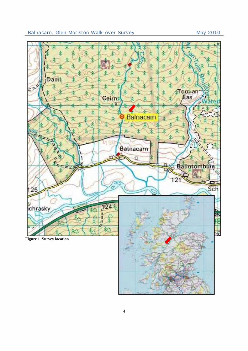
Site location, topography and geology Glen Moriston is located eight miles northwest of Fort Augustus in Inverness-shire in the Highlands of Scotland. It is situated between Loch Cluanie and Kintail to the west and Invermoriston on Loch Ness to the east. Both of the proposed pipeline routes run alongside tributaries of the River Moriston, commencing on river terraces of improved land but rising steeply over boulder-covered hillsides, which today show little evidence of past improvement. Figure 1 shows the proposed location of the Balnacarn and Achlain pipeline routes. The proposed Balnacarn route commences at a small farmstead, NGR NH 2734 1317 at 144m OD and runs northward close to the Allt Baile nan Carn to NGR NH 2743 1466 at 296m OD. The south-facing slopes comprised open grass and heather hillside rising to more steeply sloping tracts of conifer plantation and interspersed with rough grass, bracken and heather over bedrock outcrops and extensive amounts of stone. The Allt Baile nan Carn is a tributary of the River Moriston.
1 http://www.opsi.gov.uk/ACTS/acts1989/ukpga_19890029_en_1 2 http://www.opsi.gov.uk/acts/acts2000/en/ukpgaen_20000027_en_1 3 http://www.highland.gov.uk/yourenvironment/planning/developmentplans/structureplan/thehighlandstructureplan.htm 4 http://www.scotland.gov.uk/Publications/2008/10/28135841/0 5 www.historic-scotland.gov.HHER #EHG1113, EHG1368uk/pasttofuture.pdf 6 http://www.icomos.org/australia/burra.html
Balnacarn, Glen Moriston Walk-over Survey May 2010
4
Figure 1 Survey location

Balnacarn, Glen Moriston Walk-over Survey May 2010
5
Figure 2 Balnacarn proposed hydro scheme Courtesy of Dulas Hydro Generation
Balnacarn, Glen Moriston Walk-over Survey May 2010
6
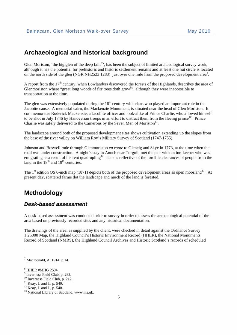
Archaeological and historical background Glen Moriston, ‘the big glen of the deep falls7’, has been the subject of limited archaeological survey work, although it has the potential for prehistoric and historic settlement remains and at least one hut circle is located on the north side of the glen (NGR NH2523 1283) just over one mile from the proposed development area8. A report from the 17th century, when Lowlanders discovered the forests of the Highlands, describes the area of Glenmoriston where “great long woods of firr trees doth grow9”, although they were inaccessible to transportation at the time. The glen was extensively populated during the 18th century with clans who played an important role in the Jacobite cause. A memorial cairn, the Mackenzie Monument, is situated near the head of Glen Moriston. It commemorates Roderick Mackenzie, a Jacobite officer and look-alike of Prince Charlie, who allowed himself to be shot in July 1746 by Hanoverian troops in an effort to distract them from the fleeing prince10. Prince Charlie was safely delivered to the Camerons by the Seven Men of Moriston11. The landscape around both of the proposed development sites shows cultivation extending up the slopes from the base of the river valley on William Roy’s Military Survey of Scotland (1747-1755). Johnson and Boswell rode through Glenmoriston en route to Glenelg and Skye in 1773, at the time when the road was under construction. A night’s stay in Anoch near Torgoil, met the pair with an inn-keeper who was emigrating as a result of his rent quadrupling12. This is reflective of the forcible clearances of people from the land in the 18th and 19th centuries. The 1st edition OS 6-inch map (1871) depicts both of the proposed development areas as open moorland13. At present day, scattered farms dot the landscape and much of the land is forested.
Methodology
Desk-based assessment A desk-based assessment was conducted prior to survey in order to assess the archaeological potential of the area based on previously recorded sites and any historical documentation. The drawings of the area, as supplied by the client, were checked in detail against the Ordnance Survey 1:25000 Map, the Highland Council’s Historic Environment Record (HHER), the National Monuments Record of Scotland (NMRS), the Highland Council Archives and Historic Scotland’s records of scheduled
7 MacDonald, A. 1914: p.14.
8 HHER #MHG 2594. 9 Inverness Field Club, p. 283. 10 Inverness Field Club, p. 212. 11 Keay, J. and J., p. 540. 12 Keay, J. and J., p. 540. 13 National Library of Scotland, www.nls.uk.
Balnacarn, Glen Moriston Walk-over Survey May 2010
7
monuments and listed buildings. Aerial photographs were checked and the map collections of the National Library of Scotland were studied. Other literary sources were also consulted.
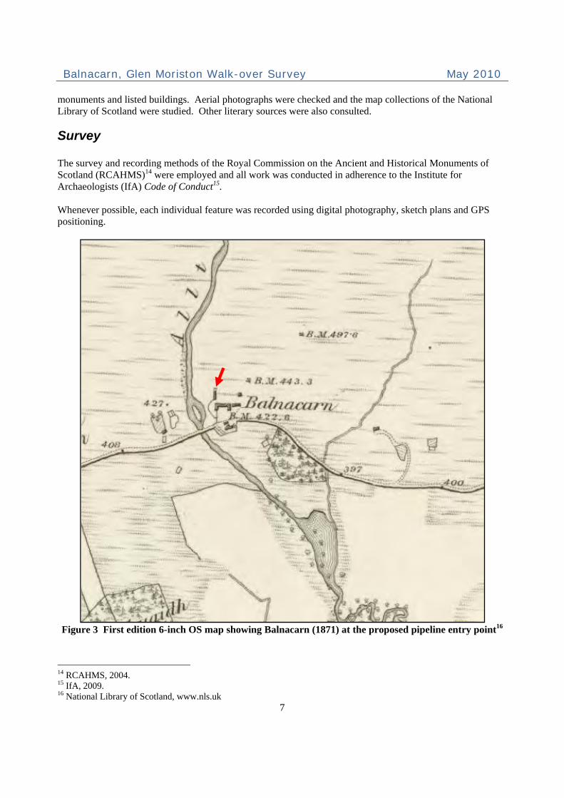
Survey The survey and recording methods of the Royal Commission on the Ancient and Historical Monuments of Scotland (RCAHMS)14 were employed and all work was conducted in adherence to the Institute for Archaeologists (IfA) Code of Conduct15. Whenever possible, each individual feature was recorded using digital photography, sketch plans and GPS positioning.
Figure 3 First edition 6-inch OS map showing Balnacarn (1871) at the proposed pipeline entry point16
14 RCAHMS, 2004. 15 IfA, 2009. 16 National Library of Scotland, www.nls.uk

Balnacarn, Glen Moriston Walk-over Survey May 2010
8
Results
Desk-based assessment
The Inverness Archive was visited on 5 May 2010 and the offices of the Highland Council Historic Environment Record (HHER) were visited on 7 May 2010 where HHER records, RAF aerial photographs, the National Monuments Record of Scotland (NMRS) and historical cartography was consulted.
The proposed pipeline route commences at Balnacarn farmstead, situated at the base of a tributary river known by the same name, Allt Baile nan Carn, and follows a route northward close to the river. The OS First edition 6-inch map shows the area as general unforested heathland17.
Roy’s Map of Scotland 1745-1763 Balnacarn Roy’s Map depicts the site of Balnacarn within an extensively populated valley along the River Moriston and at the bases of tributaries with cultivation up the hillslopes, although not extending to the area of the survey. Craskie A township referred to as ‘Craskie’ is referred to on Roy’s Map. This corresponds with Balnacarn Township (or Cnon nan Sailthean), HHER#MHG2593 / SAM #11482, which is located 200m west of Balnacarn farmstead. First Edition 6-inch OS Map Sheet The 1st edition 6-inch OS map18 shows four buildings within the survey area to the north side of the road at Balnacarn farmstead: two roofed buildings (steadings) next to the road, a third square roofed building to the northeast of the steadings and a fourth roofed building with an unroofed structure to its north side located northwest of the steadings. This corresponds with HHER entry #MHG23079.
Second Edition OS Map 1904 Sheet Balnacarn township is shown as three unroofed buildings and one roofed on the north side of the road and two roofed buildings and one enclosure to the south of the road. HHER #MHG 23079 Township at Balnacarn NH 2730 1310 A township consisting of 6 roofed buildings, 1 part-roofed, 2 unroofed and 1 unroofed of two compartments (a building with two enclosures) was depicted on the 1st edition 6-inch OS map19 and four roofed and five unroofed buildings and four enclosures were shown in the current 1974 OS 1:10000 map. HHER #MHG 2593 Balnacarn, Township 550m WSW of, Scheduled Monument 11482 NH 2680 1290 17 National Library of Scotland, www.nls.uk 18 National Library of Scotland, www.nls.uk 19 Inverness-shire (Sheet LXVII), 1874.

Balnacarn, Glen Moriston Walk-over Survey May 2010
9
Dating to the 18th, 19th and 20th centuries, a township located at 75m OD consisted of low footings or at least fourteen structures (including a well-preserved kiln-barn), clearance cairns, tracks, enclosures and a pond. It is also called Cnoc Nan Sailthean. This lies west of and outside the present project area Cairn A cairn was noted on the current OS digital mapping of the site at NH 2729 1402 at 250m OD. There was no record of this on the HHER, or on the 1st/2nd edition OS maps.
Figure 4 Locations of archaeological sites recorded by walk-over survey

Balnacarn, Glen Moriston Walk-over Survey May 2010
10
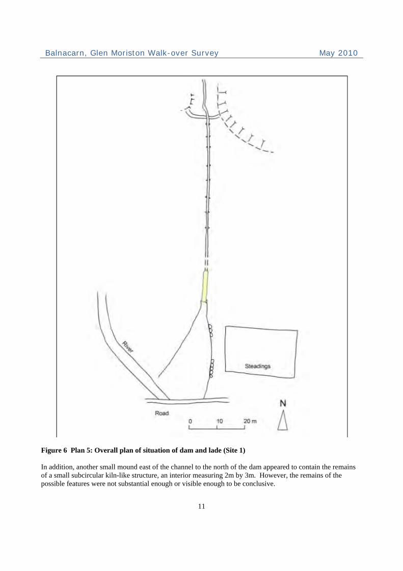
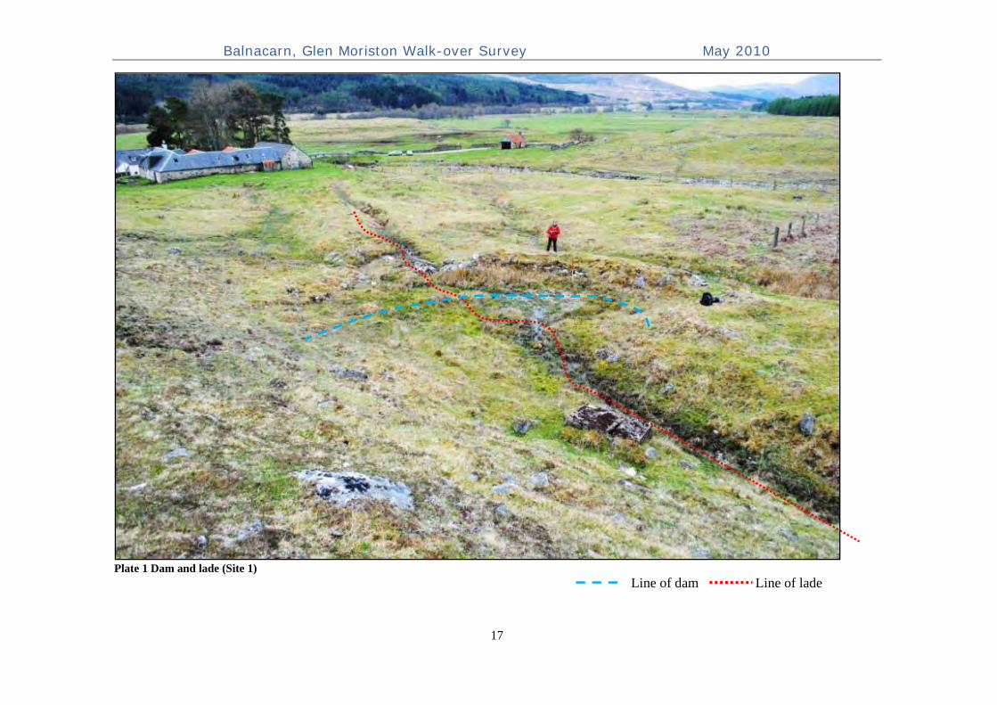
Walkover Survey An archaeological walkover survey of the pipeline route was carried out on 10 May 2010. The weather was partly cloudy with some wintry squalls. Six sites of archaeological interest were identified close to the pipeline route. Further details of these are provided in Appendix 1 below. Site 1 Dam and lade NH 2731 1322 The remains of a partially revetted drystone dam, pond and lade The site consisted of the remains of a semicircular wall of drystone construction revetted into a grass-covered mound to the west (8m long x 1-2m wide) and a stone mound (4m long, 1m wide) built up against a steep hillside to the east. The walling, bisected by a 0.7m wide sluice, formed a dam to pond water from a diverted channel of the Allt Baile nan Carn. The remains of a wooden sluice gate were still visible at the centre of the sluice with a slabbed base at a depth of 1.0m below the top of the walling.
Figure 5 Sketch - S facing elevation of sluice (Site 1)
Balnacarn, Glen Moriston Walk-over Survey May 2010
11
Figure 6 Plan 5: Overall plan of situation of dam and lade (Site 1) In addition, another small mound east of the channel to the north of the dam appeared to contain the remains of a small subcircular kiln-like structure, an interior measuring 2m by 3m. However, the remains of the possible features were not substantial enough or visible enough to be conclusive.

Balnacarn, Glen Moriston Walk-over Survey May 2010
12
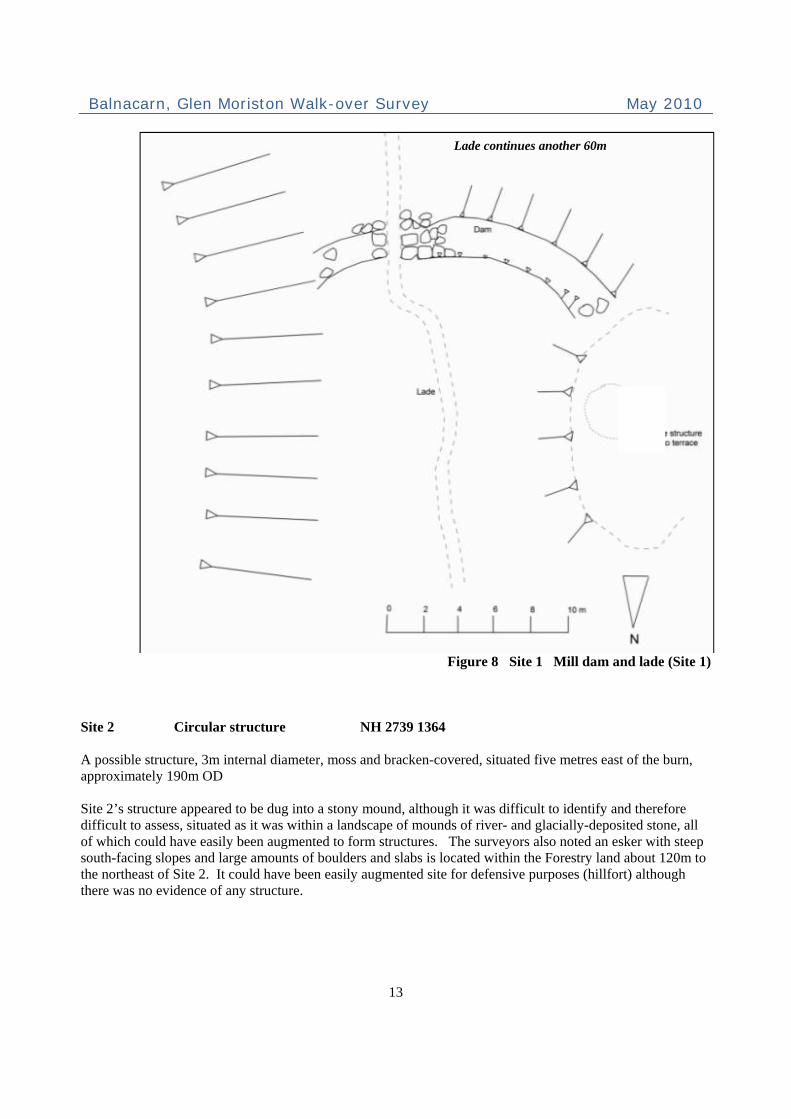
A dugout lade (0.6m wide) to channel the diverted water course continues visibly for approximately fifteen metres north of the sluice, beyond which there is no visible trace of its connection to the burn. A stone- and turf-built mound approximately 1.5m wide by 0.5m high extends the lade for twenty-five metres southward from the sluice where it disappears for a few metres and then reappears as an above ground curvilinear section of drystone walling approximately 0.75m high and 12m long with a covering of concrete. This probably reflects an area of terrain where the lade could not be dug into the ground (due to bedrock outcrops), and therefore had been constructed above ground, possibly originally containing a wooden lade structure. The lade runs on a N-S alignment from approximately 140m OD to 130m OD. A further five metres southward, two areas of walling (3m and 4m in length) are revetted into a terrace on the east side of the lade (between the lade and the steadings) and indicate a widening of the channel and could reflect where a mill wheel had once been sited. There were no other remains of a wheelhouse or wheel structure. The dam and lade clearly relate a former water mill, of which no conclusive remains could be found on the site. However, two areas of revetted walling at the base of the steadings offer a possible site for the mill wheel. Another possible site is depicted on the First edition 6-inch OS map, which shows a roofed building with an unroofed structure on its north side in the area between the dam and present steading (see Figure 2 above). There were no visible remains of this structure on the ground although it is possible that it had been washed out from river flooding or simply removed completely from the site. In addition, the First edition OS map does not depict a dam site or mill which suggests that the site was constructed after the 1870s.
Figure 7 North-facing profile of dam inner wall face (Site 1)
Balnacarn, Glen Moriston Walk-over Survey May 2010
13
Figure 8 Site 1 Mill dam and lade (Site 1)
Site 2 Circular structure NH 2739 1364 A possible structure, 3m internal diameter, moss and bracken-covered, situated five metres east of the burn, approximately 190m OD Site 2’s structure appeared to be dug into a stony mound, although it was difficult to identify and therefore difficult to assess, situated as it was within a landscape of mounds of river- and glacially-deposited stone, all of which could have easily been augmented to form structures. The surveyors also noted an esker with steep south-facing slopes and large amounts of boulders and slabs is located within the Forestry land about 120m to the northeast of Site 2. It could have been easily augmented site for defensive purposes (hillfort) although there was no evidence of any structure.
Lade continues another 60m

Balnacarn, Glen Moriston Walk-over Survey May 2010
14
Site 3 Drystone building NH 2739 1368 A rectangular drystone building with square internal corners, more rubble at the north end A small house or bothy, the only visible feature is an entrance on the west side. The moss- and heather-covered walls were situated at the base of a terrace at 195m OD on a south-facing slope. It was located within a small, fairly level grass- and bracken-covered area that could have been cultivated on a very small scale. There were no visible enclosures or boundaries although the house is situated to the east of the burn at the base of a natural terrace on a south-facing slope and thus benefitted from a sheltered position. It was probably a seasonally occupied building. (See sketch (Fig 10) and Plate 4 below)
Site 4 Drystone building NH 2755 1404 A small bothy or sheepfold with heather- and bracken-covered drystone walling 2m by 2.5m with square corners and the remains of an enclosure to then northwest side The structure is shown on the present OS mapping, with a possible enclosure. It was constructed on top of bedrock and scree on a plateau at 240m OD. The small structure would have been useful for a temporary bothy or sheepfold about 850m up the hillside from Balnacarn farmstead. (See sketch, Fig 10 above and plate 5 below) Site 5 Cairn / Monument NH 2729 1402 Finely-constructed drystone cairn or monument, 1.75m high, base width of 2.2m and top width of 0.5m From a distance, the sturdy structure appears more like a monument. Up close, it apparent that the structure is covered in large lichen and is more than a cairn built by hill walkers, as the present OS map would suggest.
Figure 9 Sketch plans: Site 3 (left); Site 4 (right)

Balnacarn, Glen Moriston Walk-over Survey May 2010
15
The viewshed from its location has extensive coverage westward up the glen to Kintail and eastward along the glen. The structure is not shown on the Second Edition OS map (1904), so it is likely that this was a monument erected within the 20th century. One local resident of the glen believes that the structure is a memorial monument built near the site of a WWII-era plane crash20. See Plate 6 below. Site 6 Stone-built ramp NH 2742 1317 A turf-covered drystone ramp, for accessing a ruined steading used for manure storage. This interesting feature reflects a 20th century re-use of a ruined steading. The ramp was constructed to allow large vehicles to access over the walls of the structure for tipping manure or dung into it for storage. See plate 7 below.
Recommendations and conclusions Although nine features of archaeological interest were identified along the two proposed pipeline routes, they should be not be difficult to safeguard as they are scattered, compact individual features. Consideration of their locations should be taken when designing further site layout and road access. Where necessary buffer zones should be established and marked on the ground to ensure they are undamaged. If damage proves unavoidable in any case the sites affected should be carefully recorded before they are destroyed. Site 1, the dam and lade, is situated within the line of the proposed route. We recommend re-routing the pipeline if possible by at least twenty metres to the east side to avoid these structures. Site 6, the ramp, is situated at the east end of the Balnacarn steading buildings, which are located at the point of road access for the pipeline route. The placement of the road access appears to bisect the group of steadings, which appears to be feasible without causing any damage to these structures. The other archaeological sites (2-5) situated along the proposed pipeline are considered to be safely out of the way of the line of the route. However, we recommend that prior to commencement of site works any sites close to access routes or other areas of possible disturbance should be identified to the contractors and marked using high visibility tape or similar. An exclusion (buffer) zone for any machinery of at least 10m should be maintained around each site.
20 Girvan, A. Pers. corr.: 20-5-10.
Balnacarn, Glen Moriston Walk-over Survey May 2010
16
References Gazeteer for Scotland. www.scottish-places.info. Girvan, Annie. Personal telephone correspondence, 20 May 2010. Highland Council Archaeology Unit. Development Guidance. Http://www.highland.gov.uk/yourenvironment/conservation/archaeology/developmentguidance.htm. Highland Council Archaeology Unit. Highland Historic Environment Record (HHER). Http://her.highland.gov.uk. Institute for Archaeologists (IfA). 2009. By-laws of the Institute for Archaeologists: Code of Conduct: Reading, IfA. Inverness Field Club and Harris, Paul. The Hub of the Highlands, The Centenary Volume of Inverness Field Club 1875-1975. The Albyn Press, Edinburgh: 1975. Keay, John and Keay, Julia. Collins Encyclopedia of Scotland. Harper Collins, London: 1994. MacDonald, Alexander, 1914. Story and Song from Loch Ness-side. Inverness: Northern Counties Newspaper & Printing & Publishing Co Ltd, p.14. National Library of Scotland. First Edition 6-inch Ordnance Survey map, Inverness-shire, Sheet LXVII (1871). National Library of Scotland. www.nls.uk. Roy, William. Military Survey of Scotland 1747-1755. Royal Commission on the Ancient and Historical Monuments of Scotland (RCAHMS). April 2004. Survey and Recording Policy.
Balnacarn, Glen Moriston Walk-over Survey May 2010
17
Plate 1 Dam and lade (Site 1)
Line of dam Line of lade

Balnacarn, Glen Moriston Walk-over Survey May 2010
18
Plate 2 Site 1: Sluice and gate (top), remains of above-ground lade (bottom)

Balnacarn, Glen Moriston Walk-over Survey May 2010
19
Plate 3 Remains of bothy / fold (Site 3)
Plate 4 Drystone building (Site 4)

Balnacarn, Glen Moriston Walk-over Survey May 2010
20
Plate 5 Cairn (Site 5)
Plate 6 Ramp (Site 6)

Balnacarn, Glen Moriston Walk-over Survey May 2010
21
Appendix 1 Index of Archaeological Features
No. Type Description Dimensions
(m) Period Condition Location
Photo No.
1 Dam and
lade
Turf- and grass-covered remains of a drystone dam, sluice and lade for a water mill no longer visible, situated on south-facing slope from 138m OD at dam to 130m OD at end of lade; Dam: well-built and revetted into earth mound (8m long, 1-2m wide, 1m high) to west side of sluice; rubble construction (4.5m long, 1m wide, 0.5-1.0m high) abutting hillslope to east side of sluice; Sluice: 0.7m wide up to 1m high between dressed stone blocks, and slabbed base; Lade, orientated N-S approximately 0.6m wide: dugout remains of lade begins approximately 15m to the north of the sluice, after passing through stone built sluice it runs through stone and earth mound approx. 49m to above-ground drystone lade 17m long;
Dam: 13 long x 1.0-
2.0 wide, up to 1.0 high; lade 66m
long, internal width
approx. 0.6, max height
above ground
0.75; sluice 1.0 high x 0.7 wide
Post-medieval,
19th century?
Degraded NH 2731 1322
1-9
2
Circular building or
natural stone mound
Low remains of moss- and bracken-covered stone footings of possible circular structure or natural feature; situated at 190 OD on a south-facing slope in close proximity to numerous mounds of naturally deposited stones and boulders
3.0 diameter, 0.5 high
Unknown Very
degraded NH 2739 1364 -
3 Drystone building
Small, rectangular moss- and bracken-covered drystone building 4.5m x 2m, situated at 195 OD on south-facing slope at the base of a slope; entrance located on west side of the building; no visible enclosure or other associated buildings although a small area of land around the structure appears to have been improved
2.0 x 4.5 internal, 0.5
high
Post-medieval
Degraded NH 2739 1368 10-12

Balnacarn, Glen Moriston Walk-over Survey May 2010
22
No. Type Description Dimensions
(m) Period Condition
Photo
No.
4 Drystone building
Roughly square heather- and bracken-covered drystone bothy or sheepfold, internal width 2.0m x 2.5m surviving up to 1.5m high; partial remains of an enclosure with 4.0m interior width to west side of building; situated at 240m OD, on a plateau of bedrock outcrop
2.0 x 2.5, up to 1.5
high; enclosure approx 4m in length, 0.75 high
Post-medieval
Degraded NH 2755 1404 13, 14
5 Cairn /
Monument
Finely constructed lichen-covered drystone monument up to 1.75m in height; built on top of bedrock outcrop at 250m OD with a commanding position E-W across the glen; probably erected near to the site of and in memory of a WWII-era plane crash
1.75 high, 2.2 base
width, 0.5 top width
Post-medieval
Well-preserved
NH 2729 1402 14, 15
6 Ramp
Turf-covered drystone ramp with rubble fill leading from track over walls of ruinous steading; functions as a store for manure / silage; located next to road at the Balnacarn steadings
6 x 2.5, up to 1.5 high
20th century
Well-preserved
NH 2742 1317 17

Balnacarn, Glen Moriston Walk-over Survey May 2010
23
Appendix 2 Index of Photographs
No. Direction
Facing Location
Site #
Site Type Notes Taken
By Date
1 S NH 7333
3284 1
Dam and lade
Partially revetted drystone dam wall and sluice somewhat obscured by reeds and grass
MKP 10/05/2010
2 SW NH 7333
3284 1
Dam and lade
Remains of drystone dam and lade orientated N-S running to the right side of the existing steading
MKP 10/05/2010
3 SW NH 7333
3284 1
Dam and lade
Remains of partly revetted drystone dam and lade running through mound orientated N-S running to the right side of the steading, towards the river
MKP 10/05/2010
4 NW NH 7333
3284 1
Dam and lade
Remains of drystone wall revetted into earthen mound, forming a dam
MKP 10/05/2010
5 NNE NH 7333
3284 1
Dam and lade
Dam sluice opening and remains of wooden sluice gate for egress of water into lade
MKP 10/05/2010
6 NNE NH 7333
3284 1
Dam and lade
Dam sluice opening and wooden remains of gate for egress of water into mill lade
MKP 10/05/2010
7 NNE NH 7321
3153 1
Dam and lade
Remains of revetted drystone walling south of lade termination; possible location of a water mill wheel expected in association with the dam and lade; dam location in upper left of photo
MKP 10/05/2010
8 N NH 7321
3153 1
Dam and lade
Southern end of remains of above-ground drystone lade structure, covered in concrete; may have once contained wooden lade
MKP 10/05/2010
9 N NH 7314
3227 1
Dam and lade
Remains of stone/earth mound dugout for mill lade, facing dam in upper left of photo
MKP 10/05/2010
10 NNW NH 7396
3685 3
Drystone building
Remains of drystone rectangular building, 4.5m x 2m, orientated N-S, with entrance on west side
MKP 10/05/2010
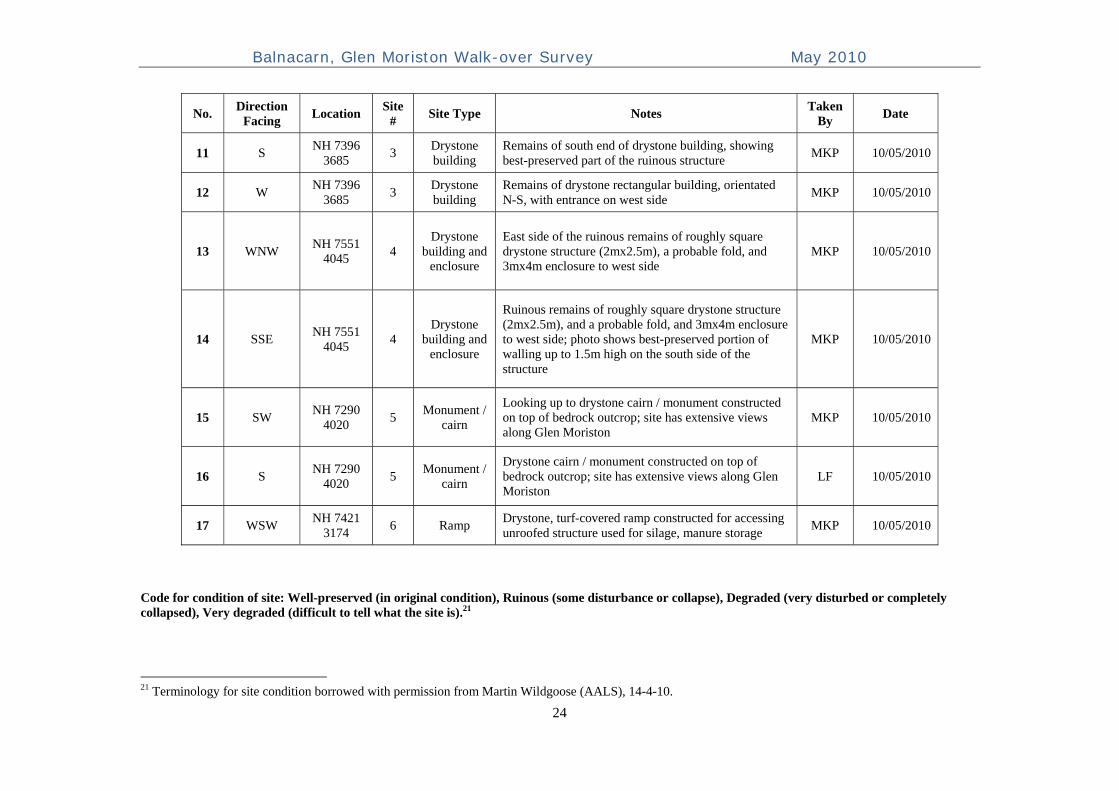
Balnacarn, Glen Moriston Walk-over Survey May 2010
24
No. Direction
Facing Location
Site #
Site Type Notes Taken
By Date
11 S NH 7396
3685 3
Drystone building
Remains of south end of drystone building, showing best-preserved part of the ruinous structure
MKP 10/05/2010
12 W NH 7396
3685 3
Drystone building
Remains of drystone rectangular building, orientated N-S, with entrance on west side
MKP 10/05/2010
13 WNW NH 7551
4045 4
Drystone building and
enclosure
East side of the ruinous remains of roughly square drystone structure (2mx2.5m), a probable fold, and 3mx4m enclosure to west side
MKP 10/05/2010
14 SSE NH 7551
4045 4
Drystone building and
enclosure
Ruinous remains of roughly square drystone structure (2mx2.5m), and a probable fold, and 3mx4m enclosure to west side; photo shows best-preserved portion of walling up to 1.5m high on the south side of the structure
MKP 10/05/2010
15 SW NH 7290
4020 5
Monument / cairn
Looking up to drystone cairn / monument constructed on top of bedrock outcrop; site has extensive views along Glen Moriston
MKP 10/05/2010
16 S NH 7290
4020 5
Monument / cairn
Drystone cairn / monument constructed on top of bedrock outcrop; site has extensive views along Glen Moriston
LF 10/05/2010
17 WSW NH 7421
3174 6 Ramp
Drystone, turf-covered ramp constructed for accessing unroofed structure used for silage, manure storage
MKP 10/05/2010
Code for condition of site: Well-preserved (in original condition), Ruinous (some disturbance or collapse), Degraded (very disturbed or completely collapsed), Very degraded (difficult to tell what the site is).21
21 Terminology for site condition borrowed with permission from Martin Wildgoose (AALS), 14-4-10.