Embed Size (px)
Citation preview

Proposed McDonald's Convenience Restaurant
84-86 High Street, Wallan
Transport Impact Assessment
Client // McDonald's Australia Limited
Office // VIC
Reference // 15M1909000
Date // 02/02/16
This co
pied d
ocum
ent is
mad
e ava
ilable
for th
e sole
purpo
se
of en
ablin
g its
cons
iderat
ion &
revie
w as pa
rt of a
plan
ning
proce
ss un
der th
e Plan
ning a
nd E
nviro
nmen
t Act
1987
.
The do
cumen
t mus
t not
be us
ed fo
r any
purpo
se w
hich m
ay
breac
h any
copy
right.

© GTA Consultants (GTA Consultants (VIC) Pty Ltd) 2015
The information contained in this document is confidential and
intended solely for the use of the client for the purpose for which it has
been prepared and no representation is made or is to be implied as
being made to any third party. Use or copying of this document in
whole or in part without the written permission of GTA Consultants
constitutes an infringement of copyright. The intellectual property
contained in this document remains the property of GTA Consultants.
Melbourne | Sydney | Brisbane
Canberra | Adelaide | Perth
Gold Coast | Townsville
TIA
/RSA
MA
- V
IC (
140918 v
7.1
0)
Proposed McDonald's Convenience Restaurant
84-86 High Street, Wallan
Transport Impact Assessment
Issue: B 02/02/16
Client: McDonald's Australia Limited
Reference: 15M1909000
GTA Consultants Office: VIC
Quality Record
Issue Date Description Prepared By Checked By Approved By Signed
A-Dr 20/08/15 Draft Justin Gale Chris Greenland Simon Davies
A 25/08/15 Final Justin Gale Chris Greenland Simon Davies
B-Dr 22/01/16 Revised Draft Justin Gale Chris Greenland Simon Davies
B 02/02/16 Revised Final Justin Gale Chris Greenland Simon Davies
This co
pied d
ocum
ent is
mad
e ava
ilable
for th
e sole
purpo
se
of en
ablin
g its
cons
iderat
ion &
revie
w as pa
rt of a
plan
ning
proce
ss un
der th
e Plan
ning a
nd E
nviro
nmen
t Act
1987
.
The do
cumen
t mus
t not
be us
ed fo
r any
purpo
se w
hich m
ay
breac
h any
copy
right.

15M1909000 // 02/02/16
Transport Impact Assessment // Issue: B
Proposed McDonald's Convenience Restaurant, 84-86 High Street, Wallan
Table of Contents
1. Introduction 1
1.1 Background 1
1.2 Development Proposal 1
1.3 Subject Site 2
1.4 Purpose of this Report 3
1.5 References 4
2. Sustainable Transport Considerations 5
2.1 Bicycle Parking & Associated Facilities 5
2.2 Pedestrian Connectivity 7
3. Car Parking Provision 8
3.1 Statutory Car Parking Requirements 8
3.2 Disabled (BCA) Car Parking Requirements 8
4. Car Parking Layout 9
4.1 Design Standards 9
4.2 Drive-Thru Operation 9
5. Loading & Waste Collection 11
5.1 Statutory Requirements 11
5.2 Proposed Provision and Adequacy of Loading Area 11
5.3 Layout 11
5.4 Refuse Collection 11
6. Traffic Impact 12
6.1 Traffic Generation 12
6.2 Traffic Distribution and Assignment 12
6.3 Traffic Impact 14
7. Conclusion 18
Appendices
A: Existing Conditions
B: Electronic Swept Path Assessments (Access)
C: Electronic Swept Path Assessments (Drive-Thru)
D: Electronic Swept Path Assessments (Loading Vehicle)
E: SIDRA Intersection Results (Existing)
This co
pied d
ocum
ent is
mad
e ava
ilable
for th
e sole
purpo
se
of en
ablin
g its
cons
iderat
ion &
revie
w as pa
rt of a
plan
ning
proce
ss un
der th
e Plan
ning a
nd E
nviro
nmen
t Act
1987
.
The do
cumen
t mus
t not
be us
ed fo
r any
purpo
se w
hich m
ay
breac
h any
copy
right.

15M1909000 // 02/02/16
Transport Impact Assessment // Issue: B
Proposed McDonald's Convenience Restaurant, 84-86 High Street, Wallan
F: SIDRA Intersection Results (Post Development)
Figures
Figure 1.1: Subject Site and its Environs (Aerial) 2
Figure 1.2: Subject Site and its Environs (Melways) 3
Figure 6.1: Weekday AM Peak Hour Site Generated Traffic Volumes (Including Non-Link
Diverted Trips) 13
Figure 6.2: Weekday PM Peak Hour Site Generated Traffic Volumes (Including Non-Link
Diverted Trips) 14
Figure 6.3: Post-Development AM Peak Hour Traffic Volumes 15
Figure 6.4: Post-Development PM Peak Hour Traffic Volumes 16
Tables
Table 2.1: Statutory Requirement for Bicycle Facilities 5
Table 3.1: Statutory Car Parking Requirements 8
Table 6.1: High Street/Queen Street Intersection – Existing Operation in AM and PM Peak15
Table 6.2: High Street/Queen Street Intersection – Post-Development Operation in AM
and PM Peak 16
Table 6.3: Queen Street/Site Access Intersection – Post-Development Operation in AM
and PM Peak 17
This co
pied d
ocum
ent is
mad
e ava
ilable
for th
e sole
purpo
se
of en
ablin
g its
cons
iderat
ion &
revie
w as pa
rt of a
plan
ning
proce
ss un
der th
e Plan
ning a
nd E
nviro
nmen
t Act
1987
.
The do
cumen
t mus
t not
be us
ed fo
r any
purpo
se w
hich m
ay
breac
h any
copy
right.

15M1909000 // 02/02/16
Transport Impact Assessment // Issue: B
Proposed McDonald's Convenience Restaurant, 84-86 High Street, Wallan 1
1. Introduction
1.1 Background
A planning permit is currently being sought for a proposed McDonald’s convenience restaurant
on land located at 84-86 High Street in Wallan.
A planning permit application was lodged with Mitchell Shire Council (PLP218/15) and upon
review, Council issued a Request for Further Information (RFI) dated 28 September 2015. Those
matters relevant to traffic and transport have been reproduced below:
“1. An amended planning report that provides consideration against proposed Amendment
C108 to they [sic] Mitchell Planning Scheme. In particular, consideration should be given to how
the proposal implements the objectives of the Wallan Structure Plan 1.
3. Any pedestrian connectivity within and around the site with connections to Hadfield Park and
the broader Wallan retail centre.”
The Applicant has now prepared amended plans to satisfy the above requests for further
information. This report has been prepared with regard for these amended plans and supersedes
the previous GTA report (dated 25/8/15).
1.2 Development Proposal
It is proposed to provide a total of 46 on-site car parking spaces including two disabled spaces2.
It should be noted that this subsequently results in one additional on-site car parking space when
compared to the previous scheme.
It is also proposed to provide a total of 114 seats, including 96 internal dining seats and 18 party
room seats, resulting in a total food consumption area of approximately 215sqm.
Vehicular access to the site is proposed via a new access point to Queen Street to the south
western corner of the site which provides the greatest offset from the High Street / Queen Street
intersection.
It is proposed to provide a total of 4 bicycle parking spaces for visitors, with a secure area for staff
bicycle parking also proposed to be provided on-site within the corral area.
A loading area of approximately 50sqm is proposed to be located on-site. Vehicle access to this
loading area is provided via the new site access point to Queen Street. The loading bay has
been designed to cater for a 14m McDonald’s loading truck to enter, circulate and exit the site in
a forward direction. An internal loading management plan is recommended to manage heavy
vehicle access into and out of the loading area as discussed later in this report.
1 Whilst this item is does not relate specifically to traffic and transport, it should be noted that the required reconfiguration of the site
layout resulted in modifications to the vehicular access, car park layout, internal accessway, loading and drive thru operation.
These items are addressed in Sections 4 and 5 of this report.
2 This provision does not include the waiting bay associated with the drive-thru facility.
1
This co
pied d
ocum
ent is
mad
e ava
ilable
for th
e sole
purpo
se
of en
ablin
g its
cons
iderat
ion &
revie
w as pa
rt of a
plan
ning
proce
ss un
der th
e Plan
ning a
nd E
nviro
nmen
t Act
1987
.
The do
cumen
t mus
t not
be us
ed fo
r any
purpo
se w
hich m
ay
breac
h any
copy
right.

15M1909000 // 02/02/16
Transport Impact Assessment // Issue: B
Proposed McDonald's Convenience Restaurant, 84-86 High Street, Wallan 2
1.3 Subject Site
The subject site is located at 84-86 High Street in Wallan. The site of 3,323sqm has a frontage of
77.61m to Queen Street and 40.03m to High Street (Northern Highway). High Street is located within
a Road Zone 1.
The site is located within a Commercial 2 Zone and is currently vacant. A number of existing
sealed pedestrian paths are located in the site’s vicinity, including a path along the western
boundary of the site that connects to the High Street/Queen Street signalised intersection and a
path alongside the west of Bentinck Street to the east of the adjacent site.
Information provided to GTA indicates that the existing land owner also owns the adjacent site to
the east, which has most recently been used as a medical centre, and will continue to be used
separately from the subject site.
The surrounding properties generally include a mix of retail, commercial and residential land uses,
with Hadfield Park located to the south of the site.
The location of the subject site, adjacent site and the surrounding environs are shown in Figure 1.1
and Figure 1.2.
Figure 1.1: Subject Site and its Environs (Aerial)
Source: www.nearmap.com.au
Subject Site
Adjacent Site
(same land owner)
This co
pied d
ocum
ent is
mad
e ava
ilable
for th
e sole
purpo
se
of en
ablin
g its
cons
iderat
ion &
revie
w as pa
rt of a
plan
ning
proce
ss un
der th
e Plan
ning a
nd E
nviro
nmen
t Act
1987
.
The do
cumen
t mus
t not
be us
ed fo
r any
purpo
se w
hich m
ay
breac
h any
copy
right.

15M1909000 // 02/02/16
Transport Impact Assessment // Issue: B
Proposed McDonald's Convenience Restaurant, 84-86 High Street, Wallan 3
Figure 1.2: Subject Site and its Environs (Melways)
(Reproduced with Permission from Melway Publishing Pty Ltd)
Further details regarding the subject site and the surrounding transport network are provided in
Appendix A.
1.4 Purpose of this Report
GTA Consultants was originally commissioned by McDonald’s Australia Limited in August 2015 to
undertake a transport impact assessment of the proposed development and has been retained
to review the abovementioned Council RFI and subsequently undertake a revised transport
impact assessment of the amended proposed development.
The report sets out an assessment of the anticipated parking, traffic and transport implications of
the proposed development, including consideration of:
i the adequacy of the proposed pedestrian, bicycle and public transport access
arrangements to the site
ii the adequacy of the proposed bicycle parking arrangements in terms of supply
(quantum) and layout
iii the adequacy of the proposed car parking provision
iv the adequacy of the proposed car park layout
v the adequacy of the proposed arrangements for loading and waste collection
vi the acceptability of the traffic impacts of the proposed development, including the
need for mitigating road works and appropriate vehicular access.
Subject Site
This co
pied d
ocum
ent is
mad
e ava
ilable
for th
e sole
purpo
se
of en
ablin
g its
cons
iderat
ion &
revie
w as pa
rt of a
plan
ning
proce
ss un
der th
e Plan
ning a
nd E
nviro
nmen
t Act
1987
.
The do
cumen
t mus
t not
be us
ed fo
r any
purpo
se w
hich m
ay
breac
h any
copy
right.

15M1909000 // 02/02/16
Transport Impact Assessment // Issue: B
Proposed McDonald's Convenience Restaurant, 84-86 High Street, Wallan 4
1.5 References
In preparing this report, reference has been made to the following:
Plans for the proposed development prepared by Richmond + Ross Architects, Plan No.
A002, Revision J, dated 19 January 2016
Wallan Structure Plan (to confirm there are no empirical requirements to be met)
Mitchell Planning Scheme (to ascertain the necessary requirements)
Australian Standard / New Zealand Standard, Parking Facilities (AS2890)
traffic surveys undertaken by GTA Consultants as referenced in the context of this report
an inspection of the site and its surrounds
other documents as nominated.
This co
pied d
ocum
ent is
mad
e ava
ilable
for th
e sole
purpo
se
of en
ablin
g its
cons
iderat
ion &
revie
w as pa
rt of a
plan
ning
proce
ss un
der th
e Plan
ning a
nd E
nviro
nmen
t Act
1987
.
The do
cumen
t mus
t not
be us
ed fo
r any
purpo
se w
hich m
ay
breac
h any
copy
right.

15M1909000 // 02/02/16
Transport Impact Assessment // Issue: B
Proposed McDonald's Convenience Restaurant, 84-86 High Street, Wallan 5
2. Sustainable Transport Considerations
2.1 Bicycle Parking & Associated Facilities
2.1.1 Overview
Clause 52.34 of the Mitchell Planning Scheme seeks to encourage cycling as a mode of travel
through the provision of appropriate bicycle parking and associated facilities. The discussion and
analysis presented below examines these requirements.
2.1.2 Statutory Requirements
Bicycle Parking Provision
Statutory requirements for the provision of bicycle parking are set out in Clause 52.34 of the
Mitchell Planning Scheme. Based on this, the statutory requirements for the provision of bicycle
facilities for the development proposal are set out in Table 2.1.
Table 2.1: Statutory Requirement for Bicycle Facilities
Use Size Statutory Rate Statutory Requirement
Employee Visitor/Shopper Employee Visitor/Shopper
Convenience
Restaurant 214.5sqm[1]
1 to each 25sqm of
floor area available
to the public
2 spaces 9 spaces 2 spaces
Total 11 spaces
[1] As calculated in the ‘Food Consumption Area’ on Richmond+Ross Drawing No. A101 (indoor dining area and party room).
Table 2.1 indicates that the proposal has a statutory bicycle parking requirement of 11 bicycle
spaces, including nine employee spaces and two visitor spaces. It is also noted Clause 52.34 of
the Mitchell Scheme states that employee bicycle parking should be provided in a bicycle locker
or secure compound.
Proposed Provision
Having regard to the proposed development, GTA consider that the employee bicycle parking
requirement is high in this instance and likely bicycle parking demands will be far less, consistent
with many other McDonald’s restaurants in Victoria.
Notwithstanding, there is potential for the secure employee bicycle parking area to be located
within the corral area to meet any staff bicycle parking demands, which is consistent with other
McDonald’s restaurants and considered appropriate to satisfy the employee parking demand.
In addition, the proposed provision of four customer spaces adjacent to the play land area
exceeds the statutory visitor requirement.
In this instance, the proposed on-site bicycle parking provision of four visitor spaces and
adequate storage for employee spaces in the corral satisifes the statutory requirement.
Associated Facilities
In addition to the requirement for bicycle parking, Clause 52.34-3 of the Mitchell Planning
Scheme requires 1 shower for the first 5 employee bicycle parking spaces and 1 shower for each
subsequent 10 employee bicycle parking spaces (if 5 or more employee bicycle parking spaces
are required).
2
This co
pied d
ocum
ent is
mad
e ava
ilable
for th
e sole
purpo
se
of en
ablin
g its
cons
iderat
ion &
revie
w as pa
rt of a
plan
ning
proce
ss un
der th
e Plan
ning a
nd E
nviro
nmen
t Act
1987
.
The do
cumen
t mus
t not
be us
ed fo
r any
purpo
se w
hich m
ay
breac
h any
copy
right.

15M1909000 // 02/02/16
Transport Impact Assessment // Issue: B
Proposed McDonald's Convenience Restaurant, 84-86 High Street, Wallan 6
Application of the above rates to the statutory employee bicycle parking requirement of nine
bicycle spaces indicates that the proposal also generates a statutory requirement of one change
room/shower.
2.1.3 Decision Guidelines
The Mitchell Planning Scheme outlines a number of guidelines to be considered for permit
applications to reduce or waive the statutory bicycle parking requirement (including the statutory
requirement relating to change rooms/showers), including (but not limited to):
“The location of the proposed land use and the distance a cyclist would need to travel
to reach the land.
The users of the land and their opportunities for bicycle travel.
The opportunities for sharing of bicycle facilities by multiple uses, either because of
variation of bicycle parking demand over time or because of efficiencies gained from
the consolidation of shared bicycle facilities.
Any relevant bicycle parking strategy or equivalent.”
These guidelines are discussed as follows.
Given the site has a requirement to provide nine employee bicycle spaces, it therefore generates
a statutory requirement to provide one shower and one change room. With respect to this
requirement, it is proposed that the statutory requirement for a shower be waived in this instance,
as per Clause 52.34-2 of the Mitchell Planning Scheme for the following reasons:
Unlike professional workplaces such as an office whereby staff are required to work for
long periods in office attire, McDonald’s staff generally work for shorter periods of time
in a fast-paced environment.
The proposed convenience restaurant will predominantly employ younger people from
the surrounding residential area. As such, employees who ride a bicycle are expected
to travel a relatively short distance (as opposed to commuter cyclists who generally
travel greater distances) and therefore do not necessitate a need to shower before
work.
McDonald’s restaurants generally do not provide employee showers due to the number
of junior employees working at each store and the limited need for these facilities.
Indeed, information provided by McDonald’s indicates that as of 2013, of the 222
restaurants in Victoria, only two have shower facilities.
Having regard to the above information, it is considered appropriate to waive the statutory
requirement for a shower facility for the development, noting that male and female staff change
rooms are provided.
2.1.4 Adequacy of Bicycle Parking/Facilities Provision
On the basis of the discussion and analysis presented above, the proposed on-site bicycle
parking provision and no on site shower/change room facility is considered to be appropriate
and sufficient.
This co
pied d
ocum
ent is
mad
e ava
ilable
for th
e sole
purpo
se
of en
ablin
g its
cons
iderat
ion &
revie
w as pa
rt of a
plan
ning
proce
ss un
der th
e Plan
ning a
nd E
nviro
nmen
t Act
1987
.
The do
cumen
t mus
t not
be us
ed fo
r any
purpo
se w
hich m
ay
breac
h any
copy
right.

15M1909000 // 02/02/16
Transport Impact Assessment // Issue: B
Proposed McDonald's Convenience Restaurant, 84-86 High Street, Wallan 7
2.2 Pedestrian Connectivity
In accordance with RFI item no. 3 reproduced in Section 1.1 of this report, the following
pedestrian infrastructure is proposed to be constructed to connect the site to the existing
pedestrian network in the vicinity:
A 1.8m wide pedestrian path along the northern side of Queen Street, connecting High
Street to the west and Bentick Street to the east.
A 1.8m wide pedestrian path connecting the west frontage of the site (that can be
used to gain access to the store entrance) to the existing High Street footpath.
The provision of these pedestrian paths is expected to provide improved connectivity between
the site and the greater pedestrian network, including connection to the existing signalised
crossing at the High Street/Queen Street intersection and the associated improved accessibility to
Hadfield Park to the south.
This co
pied d
ocum
ent is
mad
e ava
ilable
for th
e sole
purpo
se
of en
ablin
g its
cons
iderat
ion &
revie
w as pa
rt of a
plan
ning
proce
ss un
der th
e Plan
ning a
nd E
nviro
nmen
t Act
1987
.
The do
cumen
t mus
t not
be us
ed fo
r any
purpo
se w
hich m
ay
breac
h any
copy
right.

15M1909000 // 02/02/16
Transport Impact Assessment // Issue: B
Proposed McDonald's Convenience Restaurant, 84-86 High Street, Wallan 8
3. Car Parking Provision
3.1 Statutory Car Parking Requirements
Statutory requirements for the provision of car parking are set out in Clause 52.06 of the Mitchell
Planning Scheme, with parking rates specified in Table 1 to Clause 52.06-5. An assessment of the
statutory parking requirements for the development proposal is set out in Table 3.1.
Table 3.1: Statutory Car Parking Requirements
Use Patrons[1] Statutory Parking Rate Statutory Parking Requirement
Convenience
Restaurant 114 0.3 spaces per patron permitted 34 spaces
Total 34 spaces
[1] The number of patrons within the McDonald’s tenancy has been conservatively calculated as the total number of dining seats
(indoor dining area and party room).
The above assessment anticipates the development proposal has statutory requirement of
34 spaces.
In this instance, the proposed on-site parking provision of 46 car spaces exceeds the statutory
parking requirement and is considered appropriate.
It is noted that an empirical assessment based on data collected by GTA Consultants and a
number of other traffic engineering consultancies of 34 convenience restaurants including
McDonald’s restaurants suggests a peak parking rate of 0.35 spaces per indoor dining seat3.
Adopting the above rate would anticipate a peak parking demand of 34 spaces for this store,
consistent with the statutory requirement.
3.2 Disabled (BCA) Car Parking Requirements
In addition to the statutory car parking requirements in the Planning Scheme, the Building Code
of Australia (BCA) outlines requirements for the provision of car parking for people with disabilities.
An assessment of the BCA disabled car parking requirements for the development proposal
indicates that one disabled parking space is required to be provided (i.e. 1 space for every 50
car parking spaces or part thereof for up to 1,000 car parking spaces).
In this instance, the two proposed on-site disabled car parking spaces exceed the BCA
requirement and is therefore considered adequate.
3 Excludes party room seats.
3
This co
pied d
ocum
ent is
mad
e ava
ilable
for th
e sole
purpo
se
of en
ablin
g its
cons
iderat
ion &
revie
w as pa
rt of a
plan
ning
proce
ss un
der th
e Plan
ning a
nd E
nviro
nmen
t Act
1987
.
The do
cumen
t mus
t not
be us
ed fo
r any
purpo
se w
hich m
ay
breac
h any
copy
right.

15M1909000 // 02/02/16
Transport Impact Assessment // Issue: B
Proposed McDonald's Convenience Restaurant, 84-86 High Street, Wallan 9
4. Car Parking Layout
4.1 Design Standards
The proposed parking layout has been assessed in respect to the relevant Design Standards set
out in Clause 52.06 of the Mitchell Planning Scheme. A summary of compliance is set out below:
Accessways
It is proposed to construct a new vehicle access point to Queen Street along the
southern boundary of the site, approximately 80m east of the High Street/Queen Street
intersection. This double width 6.6m wide crossover provides full turning movements at
the site access.
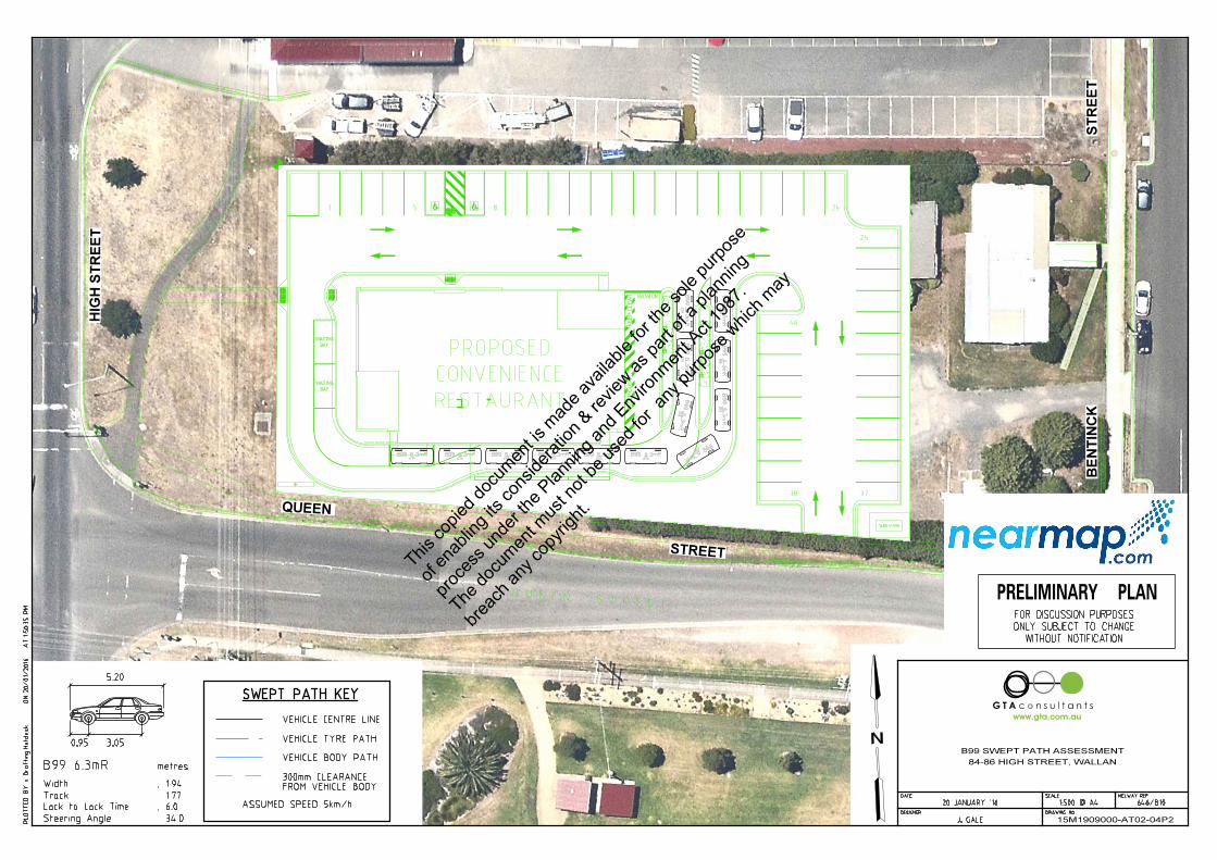
GTA has undertaken an electronic swept path assessment for two Austroads 99th
percentile design vehicles to simultaneously pass one another at the site access point.
As shown in Appendix B of this report (GTA Drawing No. 15M1909000-AT01-01P2), ingress
and egress movements can be achieved simultaneously.
The two access aisles within the car park measure 6.6m wide and 7.2m wide
respectively which exceed the minimum requirements of the Planning Scheme.
A turnaround area is proposed at the end of the car park in the northeast corner of the
site. Provision of this turnaround area will ensure vehicles can enter, circulate and exit
the site in forwards direction in the unlikely instance that all car spaces are occupied.
Car Parking Spaces
All regular car parking spaces measure a minimum 5.4m long and 2.6m wide accessed
via a minimum 6.6m wide aisle. These dimensions exceed the minimum requirements of
the Planning Scheme and are considered to be appropriate.
The two disabled car parking spaces measure 5.4m long and 2.4m wide and have a
shared zone 5.4m long and 2.4m wide adjacent both spaces (containing a bollard).
These spaces are designed in accordance with Australian/New Zealand Standard for
Off-Street Parking for People with Disabilities (AS/NZS 2890.6-2009) and are considered
to be appropriate.
4.2 Drive-Thru Operation
4.2.1 Operation
The drive-thru is proposed to contain two order points, one cashier point and two servery points,
with a minimum drive-thru accessway width of 3.0m. As such, this facility is considered
appropriate for the proposed development for efficiently managing drive-thru traffic.
In addition, GTA has undertaken electronic swept path analysis that demonstrates that an
Austroads 99th percentile design vehicle can adequately enter the drive-thru, circulate around a
stationary vehicle at the western servery point and/or waiting bay and circulate to exit to Queen
Street.
For reference, this assessment is presented in Appendix C of this report (GTA Drawing No’s.
15M1909000-AT01-02P2 and 15M1909000-AT01-03P2).
4
This co
pied d
ocum
ent is
mad
e ava
ilable
for th
e sole
purpo
se
of en
ablin
g its
cons
iderat
ion &
revie
w as pa
rt of a
plan
ning
proce
ss un
der th
e Plan
ning a
nd E
nviro
nmen
t Act
1987
.
The do
cumen
t mus
t not
be us
ed fo
r any
purpo
se w
hich m
ay
breac
h any
copy
right.
15M1909000 // 02/02/16
Transport Impact Assessment // Issue: B
Proposed McDonald's Convenience Restaurant, 84-86 High Street, Wallan 10
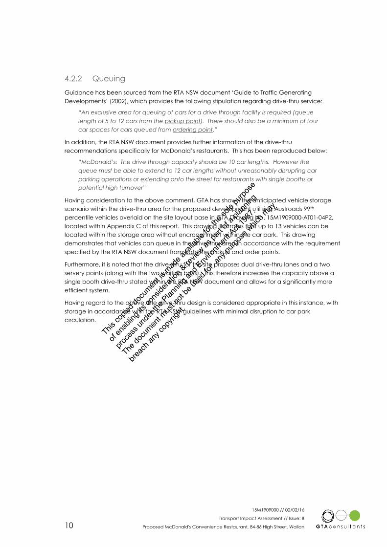
4.2.2 Queuing
Guidance has been sourced from the RTA NSW document ‘Guide to Traffic Generating
Developments’ (2002), which provides the following stipulation regarding drive-thru service:
“An exclusive area for queuing of cars for a drive through facility is required (queue
length of 5 to 12 cars from the pickup point). There should also be a minimum of four
car spaces for cars queued from ordering point.”
In addition, the RTA NSW document provides further information of the drive-thru
recommendations specifically for McDonald’s restaurants. This has been reproduced below:
“McDonald’s: The drive through capacity should be 10 car lengths. However the
queue must be able to extend to 12 car lengths without unreasonably disrupting car
parking operations or extending onto the street for restaurants with single booths or
potential high turnover”
Having consideration to the above comment, GTA has shown the anticipated vehicle storage
scenario within the drive-thru area for the proposed development utilising Austroads 99th
percentile vehicles overlaid on the site layout base in GTA Drawing No. 15M1909000-AT01-04P2,
located within Appendix C of this report. This drawing illustrates that up to 13 vehicles can be
located within the storage area without encroachment within the car park. This drawing
demonstrates that vehicles can queue in the drive-thru area in accordance with the requirement
specified by the RTA NSW document from both the pickup and order points.
Furthermore, it is noted that the drive-thru for this site proposes dual drive-thru lanes and a two
servery points (along with the two waiting bays). This therefore increases the capacity above a
single booth drive-thru stated within the RTA NSW document and allows for a significantly more
efficient system.
Having regard to the above, the drive-thru design is considered appropriate in this instance, with
storage in accordance with the RTA NSW guidelines with minimal disruption to car park
circulation.
This co
pied d
ocum
ent is
mad
e ava
ilable
for th
e sole
purpo
se
of en
ablin
g its
cons
iderat
ion &
revie
w as pa
rt of a
plan
ning
proce
ss un
der th
e Plan
ning a
nd E
nviro
nmen
t Act
1987
.
The do
cumen
t mus
t not
be us
ed fo
r any
purpo
se w
hich m
ay
breac
h any
copy
right.

15M1909000 // 02/02/16
Transport Impact Assessment // Issue: B
Proposed McDonald's Convenience Restaurant, 84-86 High Street, Wallan 11
5. Loading & Waste Collection
5.1 Statutory Requirements
Clause 52.07 of the Mitchell Planning Scheme is applicable where buildings or works are
constructed for the manufacture, servicing, storage or sale of goods or materials.
The Clause anticipates the development proposal has a statutory requirement of a loading area
of 27.4sqm.
5.2 Proposed Provision and Adequacy of Loading Area
A loading area of approximately 50sqm is located to the immediate east of the building. This
provision exceeds the statutory requirements and is therefore considered adequate.
5.3 Layout
The McDonald’s loading vehicle will access the loading area in a forward direction from Queen
Street and reverse into the loading area. Once loading is complete, the vehicle will then exit the
site to Queen Street in a forward direction.
The loading area has been designed to exceed Planning Scheme requirements and its
accessibility by vehicles of a size up to and including 14m McDonald’s trucks has been confirmed
via swept path assessment. The results of this swept path assessment are shown in Appendix D of
this report (GTA Drawing Nos. 15M1909000-AT01-05P2 and 15M1909000-AT01-06P2).
It is noted that in performing this manoeuvre, approximately four car spaces to the north of the
loading area are required to be vacant. A loading management plan is recommended to be
prepared by the Applicant to provide detail on how these car parking spaces will be managed.
It is expected that removable bollards (or similar) could be placed in these spaces by staff to
physically prevent vehicles accessing them during the early morning period prior to any
scheduled morning loading activity.
The temporary ‘loss’ of up to four spaces during loading activity is not expected to impact on car
parking availability as the balance of car parking spaces (42 spaces) would still exceed the
statutory requirement for the development (34 spaces). In addition, loading activity is expected
to occur outside of typical store peak periods when car parking demand is lower (i.e. the early
morning).
5.4 Refuse Collection
The proposal incorporates a dedicated area for bin storage area located in the corral area. It is
understood that the bins will be collected from this area by a private waste collection contractor.
5
This co
pied d
ocum
ent is
mad
e ava
ilable
for th
e sole
purpo
se
of en
ablin
g its
cons
iderat
ion &
revie
w as pa
rt of a
plan
ning
proce
ss un
der th
e Plan
ning a
nd E
nviro
nmen
t Act
1987
.
The do
cumen
t mus
t not
be us
ed fo
r any
purpo
se w
hich m
ay
breac
h any
copy
right.

15M1909000 // 02/02/16
Transport Impact Assessment // Issue: B
Proposed McDonald's Convenience Restaurant, 84-86 High Street, Wallan 12
6. Traffic Impact
6.1 Traffic Generation
An estimate of the traffic generation of the proposed development was made with reference to
recent surveys undertaken by GTA Consultants of several existing McDonald’s convenience
restaurants. The data suggests an average weekday AM and PM peak hour traffic generation of
approximately 170 vehicle movements per hour.
6.2 Traffic Distribution and Assignment
The directional distribution and assignment of traffic generated by the proposed development
will be influenced by a number of factors, including the:
i configuration of the arterial road network in the immediate vicinity of the site
ii existing operation of intersections providing access between the local and arterial road
network
iii distribution of households in the vicinity of the site
iv likely distribution of employee’s residences in relation to the site
v configuration of access points to the site.
Having consideration to the above and based on the existing turning movement data for the
High Street/Queen Street intersection, the following directional distributions have been assumed
in each weekday peak hour:
AM Peak
High Street (north) 50% arriving and 30% departing
High Street (south) 30% arriving and 50% departing
Queen Street (east) 5%
Queen Street (west) 15%.
PM Peak
High Street (north) 30% arriving and 50% departing
High Street (south) 50% arriving and 30% departing
Queen Street (east) 5%
Queen Street (west) 15%.
In addition, a 50:50 directional split of traffic (i.e. the ratio between the inbound and outbound
traffic movements) has been assumed.
6.2.1 Characteristic Trip Types
An important characteristic of the traffic generation for the proposed convenience restaurant is
the different types of trips which may occur. These different trip types correspond to:
‘Primary Trips’
‘Link-diverted Trips’
‘Non-link-diverted Trips’
6
This co
pied d
ocum
ent is
mad
e ava
ilable
for th
e sole
purpo
se
of en
ablin
g its
cons
iderat
ion &
revie
w as pa
rt of a
plan
ning
proce
ss un
der th
e Plan
ning a
nd E
nviro
nmen
t Act
1987
.
The do
cumen
t mus
t not
be us
ed fo
r any
purpo
se w
hich m
ay
breac
h any
copy
right.

15M1909000 // 02/02/16
Transport Impact Assessment // Issue: B
Proposed McDonald's Convenience Restaurant, 84-86 High Street, Wallan 13
Primary trips and link-diverted trips involve a vehicle either making a special trip or a modification
of the route to an existing trip. Non-link-diverted trips, on the other hand, correspond to those
trips which do not involve a diversion from the route that would otherwise have been taken, or in
other words are trips generated by passing traffic. The important distinction here is that it is only
primary trips and link-diverted trips which impact upon the external road network. Non-link-
diverted trips are already present on the adjacent road network, and although these trips need
to be considered in the design of access driveways, turning lanes and so on, they do not
constitute additional traffic per se.
A significant proportion of traffic is anticipated to access the site during the road network peak
hour as non-link-diverted trips and as such, it is anticipated that few new trips would be
generated along High Street. In this respect, reference is made to the ‘RTA NSW – Guide to Traffic
Generating Developments’ which in respect to McDonald’s convenience restaurants states the
following:
“The proportion of passing trade is typically about 35%. This discount should be taken into
account in assessing external traffic impact.”
The below assessment therefore assumes that 35% of traffic movements will be from existing
external road traffic on High Street.
Based on the above, Figure 6.1 and Figure 6.2 have been prepared to show the estimated
marginal increase in turning movements during the AM and PM peak hour in the vicinity of the
subject site.
Figure 6.1: Weekday AM Peak Hour Site Generated Traffic Volumes (Including Non-Link Diverted Trips)
0 =
13 " 0 -15 43 81 = 81 4
0 ? 8 $ 9 0 " 8 9
: # ; < 26 < 4
0 -9 26 ! 13 ! 0
> 43
AM PEAK HOUR
SITE GENERATED TRAFFIC
(LESS PASSER BY TRAFFIC)
Hig
h S
tree
t (N
ort
her
n H
wy)
Subject
Site
Queen Street
This co
pied d
ocum
ent is
mad
e ava
ilable
for th
e sole
purpo
se
of en
ablin
g its
cons
iderat
ion &
revie
w as pa
rt of a
plan
ning
proce
ss un
der th
e Plan
ning a
nd E
nviro
nmen
t Act
1987
.
The do
cumen
t mus
t not
be us
ed fo
r any
purpo
se w
hich m
ay
breac
h any
copy
right.

15M1909000 // 02/02/16
Transport Impact Assessment // Issue: B
Proposed McDonald's Convenience Restaurant, 84-86 High Street, Wallan 14
Figure 6.2: Weekday PM Peak Hour Site Generated Traffic Volumes (Including Non-Link Diverted Trips)
6.3 Traffic Impact
6.3.1 Existing Conditions
The operation of the intersection of High Street and Queen Street has been assessed using SIDRA
INTERSECTION 6.14, a computer based modelling package which calculates intersection
performance.
The commonly used measure of intersection performance is referred to as the Degree of
Saturation (DOS). The DOS represents the flow-to-capacity ratio for the most critical movement
on each leg of the intersection. For signalised intersections, a DOS of around 0.95 has been
typically considered the ‘ideal’ limit, beyond which queues and delays increase
disproportionately5.
Table 6.1 presents a summary of the existing operation of the intersection (based on the traffic
volumes shown in Figure A.7 and Figure A.8 in Appendix A), with full results presented in Appendix
E of this report.
4 Program used under license from Akcelik & Associates Pty Ltd.
5 SIDRA INTERSECTION adopts the following criteria for Level of Service assessment:
Level of Service Intersection Degree of Saturation (DOS)
Unsignalised Intersection Signalised Intersection Roundabout
A Excellent <=0.60 <=0.60 <=0.60
B Very Good 0.60-0.70 0.60-0.70 0.60-0.70
C Good 0.70-0.80 0.70-0.90 0.70-0.85
D Acceptable 0.80-0.90 0.90-0.95 0.85-0.95
E Poor 0.90-1.00 0.95-1.00 0.95-1.00
F Very Poor >=1.0 >=1.0 >=1.0
0 =
13 " 0 -9 26 81 = 81 4
0 ? 8 $ 9 0 " 8 9
: # ; < 43 < 4
0 -15 43 ! 13 ! 0
> 26
PM PEAK HOUR
SITE GENERATED TRAFFIC
(LESS PASSER BY TRAFFIC)
Hig
h S
tree
t (N
ort
her
n H
wy)
Subject
Site
Queen Street
This co
pied d
ocum
ent is
mad
e ava
ilable
for th
e sole
purpo
se
of en
ablin
g its
cons
iderat
ion &
revie
w as pa
rt of a
plan
ning
proce
ss un
der th
e Plan
ning a
nd E
nviro
nmen
t Act
1987
.
The do
cumen
t mus
t not
be us
ed fo
r any
purpo
se w
hich m
ay
breac
h any
copy
right.
15M1909000 // 02/02/16
Transport Impact Assessment // Issue: B
Proposed McDonald's Convenience Restaurant, 84-86 High Street, Wallan 15
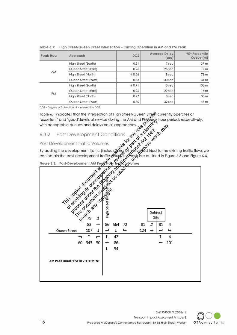
Table 6.1: High Street/Queen Street Intersection – Existing Operation in AM and PM Peak
Peak Hour Approach DOS Average Delay
(sec)
95th Percentile
Queue (m)
AM
High Street (South) 0.31 7 sec 37 m
Queen Street (East) 0.26 26 sec 17 m
High Street (North) # 0.56 8 sec 78 m
Queen Street (West) 0.53 30 sec 31 m
PM
High Street (South) # 0.71 8 sec 108 m
Queen Street (East) 0.26 29 sec 16 m
High Street (North) 0.27 8 sec 30 m
Queen Street (West) 0.70 32 sec 47 m
DOS – Degree of Saturation, # - Intersection DOS
Table 6.1 indicates that the intersection of High Street/Queen Street currently operates at
‘excellent’ and ‘good’ levels of service during the AM and PM peak hour periods respectively,
with acceptable queues and delays on all approaches.
6.3.2 Post Development Conditions
Post Development Traffic Volumes
By adding the development traffic (including non-link diverted trips) to the existing traffic flows we
can obtain the post-development traffic volumes. These are outlined in Figure 6.3 and Figure 6.4.
Figure 6.3: Post-Development AM Peak Hour Traffic Volumes
79 =
83 " 86 564 72 81 = 81 4
107 ? 8 $ 9 124 " 8 9
: # ; < 42 < 4
60 343 50 ! 86 ! 101
> 54
AM PEAK HOUR POST DEVELOPMENT
Hig
h S
tree
t (N
ort
her
n H
wy)
Subject
Site
Queen Street
This co
pied d
ocum
ent is
mad
e ava
ilable
for th
e sole
purpo
se
of en
ablin
g its
cons
iderat
ion &
revie
w as pa
rt of a
plan
ning
proce
ss un
der th
e Plan
ning a
nd E
nviro
nmen
t Act
1987
.
The do
cumen
t mus
t not
be us
ed fo
r any
purpo
se w
hich m
ay
breac
h any
copy
right.

15M1909000 // 02/02/16
Transport Impact Assessment // Issue: B
Proposed McDonald's Convenience Restaurant, 84-86 High Street, Wallan 16
Figure 6.4: Post-Development PM Peak Hour Traffic Volumes
Post Development Traffic Impact
The impact of the development traffic upon intersections in the vicinity of the site immediately
was assessed using SIDRA INTERSECTION 6. On the basis of the turning movement estimates
presented above, Table 6.2 and Table 6.3 presents a summary of the anticipated future
operation of the nominated intersections following the full development of the site. Detailed
results of this analysis are provided in Appendix F of this report.
Table 6.2: High Street/Queen Street Intersection – Post-Development Operation in AM and PM Peak
Peak Hour Approach DOS Average Delay
(sec)
95th Percentile
Queue (m)
AM
High Street (South) 0.35 11 sec 44 m
Queen Street (East) 0.30 23 sec 26 m
High Street (North) # 0.71 13 sec 104 m
Queen Street (West) 0.44 25 sec 30 m
PM
High Street (South) # 0.84 18 sec 163 m
Queen Street (East) 0.35 25 sec 20 m
High Street (North) 0.34 12 sec 41 m
Queen Street (West) 0.46 25 sec 42 m
DOS – Degree of Saturation, # - Intersection DOS
Table 6.2 indicates that post development, the intersection of High Street/Queen Street will
contain ‘good’ levels of service in both the AM and PM peak hours.
Critically, it should be noted that as the vehicle crossover to Queen Street is proposed to be
located approximately 80m east of the High Street/Queen Street intersection, Table 6.2 indicates
that the 95th percentile queue on the Queen Street (east approach) is not expected to extend
back to the access point with a 95th percentile queue length of 26m during the AM peak hour.
114 =
114 " 61 303 41 81 = 81 4
107 ? 8 $ 9 165 " 8 9
: # ; < 75 < 4
104 788 91 ! 82 ! 113
> 37
PM PEAK HOUR POST DEVELOPMENT
Hig
h S
tree
t (N
ort
her
n H
wy)
Subject
Site
Queen Street
This co
pied d
ocum
ent is
mad
e ava
ilable
for th
e sole
purpo
se
of en
ablin
g its
cons
iderat
ion &
revie
w as pa
rt of a
plan
ning
proce
ss un
der th
e Plan
ning a
nd E
nviro
nmen
t Act
1987
.
The do
cumen
t mus
t not
be us
ed fo
r any
purpo
se w
hich m
ay
breac
h any
copy
right.

15M1909000 // 02/02/16
Transport Impact Assessment // Issue: B
Proposed McDonald's Convenience Restaurant, 84-86 High Street, Wallan 17
Table 6.3: Queen Street/Site Access Intersection – Post-Development Operation in AM and PM Peak
Peak Hour Approach DOS Average Delay
(sec)
95th Percentile
Queue (m)
AM
Queen Street (East) 0.06 0 sec 0 m
Site Access (North) 0.09 6 sec 2 m
Queen Street (West) # 0.11 2 sec 0 m
PM
Queen Street (East) 0.06 0 sec 0 m
Site Access (North) 0.09 7 sec 2 m
Queen Street (West) # 0.14 2 sec 0 m
DOS – Degree of Saturation, # - Intersection DOS
Table 6.3 indicates that post development the intersection of Queen Street/Site Access is
expected to operate at an ‘excellent’ level of service under AM and PM peak hour conditions
with minimal queues and delays on all approaches.
As described earlier, a DOS of around 0.95 for signalised intersections and 0.90 for unsignalised
intersections has traditionally been considered the practical limit beyond which intersection
performance is unsatisfactory, as beyond this value queues and delays increase
disproportionately. On this criterion, the calculated DOS for both intersections suggest that they
can be expected to operate satisfactorily following full development of the site.
This co
pied d
ocum
ent is
mad
e ava
ilable
for th
e sole
purpo
se
of en
ablin
g its
cons
iderat
ion &
revie
w as pa
rt of a
plan
ning
proce
ss un
der th
e Plan
ning a
nd E
nviro
nmen
t Act
1987
.
The do
cumen
t mus
t not
be us
ed fo
r any
purpo
se w
hich m
ay
breac
h any
copy
right.
15M1909000 // 02/02/16
Transport Impact Assessment // Issue: B
Proposed McDonald's Convenience Restaurant, 84-86 High Street, Wallan 18
7. Conclusion
Based on the analysis and discussion presented within this report, the following conclusions are
made:
i The proposed development generates a statutory parking requirement of 34 car
parking spaces. Surveys of several other McDonald’s restaurants also indicate a peak
car parking demand of approximately 34 car parking spaces can be expected.
ii The proposed supply of 46 spaces exceeds the statutory requirement and the
anticipated peak car parking demand, and is considered to be appropriate.
iii The proposed car parking layout is consistent with the dimensional requirements as set
out in the Mitchell Planning Scheme and/or Australian/New Zealand Standards for Off
Street Car Parking (AS/NZS2890.1:2004 and AS/NZS2890.6:2009).
iv The proposed provision of two new sealed pedestrian paths (each 1.8m wide) is
expected to provide improved connectivity between the site and the greater
pedestrian network, including connection to the existing signalised crossing at the High
Street/Queen Street intersection and the associated improved accessibility to Hadfield
Park to the south.
v It is proposed to provide four visitor bicycle parking spaces as well as additional storage
for staff bicycle spaces within the corral area.
vi Change room facilities are proposed to be provided for staff. However, a shower is not
considered necessary given the relatively short distances employees generally travel
and the type of work undertaken.
vii The provision of loading exceeds the statutory requirement and is considered adequate
for the development.
viii A loading management plan is recommended to be prepared by the Applicant to
physically prevent vehicles accessing the adjacent four on-site parking spaces prior to
any scheduled loading activity.
ix The site is expected to generate up to 170 vehicle movements in any weekday peak
hour.
x There is adequate capacity in the surrounding road network to cater for the traffic
generated by the proposed development.
7
This co
pied d
ocum
ent is
mad
e ava
ilable
for th
e sole
purpo
se
of en
ablin
g its
cons
iderat
ion &
revie
w as pa
rt of a
plan
ning
proce
ss un
der th
e Plan
ning a
nd E
nviro
nmen
t Act
1987
.
The do
cumen
t mus
t not
be us
ed fo
r any
purpo
se w
hich m
ay
breac
h any
copy
right.

15M1909000 // 02/02/16
Transport Impact Assessment // Issue: B
Proposed McDonald's Convenience Restaurant, 84-86 High Street, Wallan
Appendix A
Existing Conditions
Ap
pe
nd
ix A
This co
pied d
ocum
ent is
mad
e ava
ilable
for th
e sole
purpo
se
of en
ablin
g its
cons
iderat
ion &
revie
w as pa
rt of a
plan
ning
proce
ss un
der th
e Plan
ning a
nd E
nviro
nmen
t Act
1987
.
The do
cumen
t mus
t not
be us
ed fo
r any
purpo
se w
hich m
ay
breac
h any
copy
right.

15M1909000 // 02/02/16
Transport Impact Assessment // Issue: B
Proposed McDonald's Convenience Restaurant, 84-86 High Street, Wallan
A.1 Road Network
A.1.1 Adjoining Roads
High Street (Northern Highway)
High Street functions as a primary arterial road (under VicRoads jurisdiction) and is located within
a Road Zone (Category 1) in the Mitchell Planning Scheme. It is a two-way road aligned in a
north-south direction and generally configured with a 2-lane, 15 metre wide carriageway set
within a 55 metre wide road reserve (approx.).
High Street carries approximately 15,700 vehicles per day6 and is shown in Figure A.1 and A.2.
Figure A.1: High Street (Looking North) Figure A.2: High Street (Looking South)
Queen Street
Queen Street functions as a local street (Council controlled). It is a two-way road aligned in an
east-west direction and configured with a 2-lane, 7 metre wide carriageway set within a 20 metre
wide road reserve (approx.).
Queen Street carries approximately 2,500 vehicles per day7 and is shown in Figure A.3 and A.4.
Figure A.3: Queen Street (Looking East) Figure A.4: Queen Street (Looking West)
6 Based on weeklong pneumatic tube counts commissioned by McDonald’s Australia Limited for High Street (south of Queen Street
from 16-22 October 2014.
7 Based on weeklong SCATS traffic volume data obtained from VicRoads for a weeklong period (between 15 -21 March 2015) at the
High Street/Queen Street signalised intersection.
This co
pied d
ocum
ent is
mad
e ava
ilable
for th
e sole
purpo
se
of en
ablin
g its
cons
iderat
ion &
revie
w as pa
rt of a
plan
ning
proce
ss un
der th
e Plan
ning a
nd E
nviro
nmen
t Act
1987
.
The do
cumen
t mus
t not
be us
ed fo
r any
purpo
se w
hich m
ay
breac
h any
copy
right.

15M1909000 // 02/02/16
Transport Impact Assessment // Issue: B
Proposed McDonald's Convenience Restaurant, 84-86 High Street, Wallan
Bentinck Street
Bentinck Street functions as a local street (Council controlled). It is a two-way road aligned in a
north-south direction and configured with a 2-lane, 7 metre wide carriageway set within a 20
metre wide road reserve (approx.).
Bentinck Street is shown in Figure A.5 and A.6.
Figure A.5: Bentinck Street (Looking North) Figure A.6: Bentinck Street (Looking South)
Other Roads
Other roads within the vicinity of the site include Wellington Street, Watson Street and Windham
Street.
A.1.2 Surrounding Intersections
Key intersections in the vicinity of the site include:
High Street (Northern Highway) / Queen Street (signalised X-intersection)
Queen Street / Bentinck Street (unsignalised X-intersection).
A.1.3 Traffic Volumes
GTA Consultants obtained weeklong SCATS traffic volume data from VicRoads (15-21 March
2015) for the High Street (Northern Highway)/Queen Street signalised intersection to determine
the existing peak hour traffic volumes in the vicinity of the site. In addition, GTA also undertook
sample traffic movement counts at the intersection to determine the directional split of traffic in
shared detector lanes.
The AM and PM peak hour traffic volumes are shown in Figure A.7 and Figure A.8, respectively.
This co
pied d
ocum
ent is
mad
e ava
ilable
for th
e sole
purpo
se
of en
ablin
g its
cons
iderat
ion &
revie
w as pa
rt of a
plan
ning
proce
ss un
der th
e Plan
ning a
nd E
nviro
nmen
t Act
1987
.
The do
cumen
t mus
t not
be us
ed fo
r any
purpo
se w
hich m
ay
breac
h any
copy
right.

15M1909000 // 02/02/16
Transport Impact Assessment // Issue: B
Proposed McDonald's Convenience Restaurant, 84-86 High Street, Wallan
Figure A.7: Existing AM Peak Hour Traffic Volumes
Figure A.8: Existing PM Peak Hour Traffic Volumes
79 =
70 " 86 564 30 0 = 0 0
107 ? 8 $ 9 124 " 8 9
: # ; < 16 < 0
60 343 24 ! 73 ! 101
> 12
AM PEAK HOUR TRAFFIC VOLUMES
Time: 8:00am-9:00am
Subject
Site
Queen Street
Hig
h S
tree
t (N
ort
her
n H
wy)
114 =
101 " 61 303 16 0 = 0 0
107 ? 8 $ 9 165 " 8 9
: # ; < 32 < 0
104 788 48 ! 70 ! 113
> 11
PM PEAK HOUR TRAFFIC VOLUMES
Time: 5:15pm-6:15pm
Hig
h S
tree
t (N
ort
her
n H
wy)
Subject
Site
Queen Street
This co
pied d
ocum
ent is
mad
e ava
ilable
for th
e sole
purpo
se
of en
ablin
g its
cons
iderat
ion &
revie
w as pa
rt of a
plan
ning
proce
ss un
der th
e Plan
ning a
nd E
nviro
nmen
t Act
1987
.
The do
cumen
t mus
t not
be us
ed fo
r any
purpo
se w
hich m
ay
breac
h any
copy
right.

15M1909000 // 02/02/16
Transport Impact Assessment // Issue: B
Proposed McDonald's Convenience Restaurant, 84-86 High Street, Wallan
A.2 Safety Assessment
A review of the reported casualty accident history for the roads and intersections adjoining the
subject site has been sourced from VicRoads CrashStats accident database. This database
records all accidents causing injury that have occurred in Victoria since 1987 (as recorded by
Victorian Police) and categorises these accidents as follows:
Fatal injury: at least one person was killed in the accident or died within 30 days as a
result of the accident.
Serious injury: at least one person was sent to hospital as a result of the accident.
Other injury: at least one person required medical treatment as a result of the accident.
A summary of the accidents in the vicinity of the site for the last available five year period
January 2009 to December 2013) is presented in Table A.1.
Table A.1: Casualty Accident History
Location Accident No.
Fatality Serious Injury Other Injury
Nearby Intersections
High Street / Queen Street - - 1
Source: VicRoads
Table A.1 indicates that one casualty accident has been recorded in the last available five year
period in the vicinity of the site. It should also be noted that no accidents have been reported on
Queen Street in the vicinity of the proposed site access points.
A.3 Sustainable Transport Infrastructure
A.3.1 Public Transport
Figure A.9 shows the subject site in relation to the existing bus route within its vicinity.
This co
pied d
ocum
ent is
mad
e ava
ilable
for th
e sole
purpo
se
of en
ablin
g its
cons
iderat
ion &
revie
w as pa
rt of a
plan
ning
proce
ss un
der th
e Plan
ning a
nd E
nviro
nmen
t Act
1987
.
The do
cumen
t mus
t not
be us
ed fo
r any
purpo
se w
hich m
ay
breac
h any
copy
right.

15M1909000 // 02/02/16
Transport Impact Assessment // Issue: B
Proposed McDonald's Convenience Restaurant, 84-86 High Street, Wallan
Figure A.9: Public Transport Map
A.3.2 Pedestrian Infrastructure
Formal pedestrian paths within the vicinity of the site are located as follows:
Both sides of High Street to the north of the High Street/Queen Street intersection8
Both sides of Queen Street to the west of the High Street/Queen Street intersection
Eastern side of High Street to the south of the High Street/Queen Street intersection
Southern side of Queen Street to the east of the High Street/Queen Street intersection.
Signalised pedestrian crossing points are located on all approaches of the High Street/Queen
Street intersection.
A.3.3 Cycle Infrastructure
On-road bicycle lanes currently exist on both sides of High Street providing cyclist connection
north-south adjacent the site. The southbound bicycle lane on High Street is provided in Figure
A.10.
8 It is noted that the pedestrian path on the eastern side of High Street provides connection between the signalised pedestrian
crossing (High Street/Queen Street) and the Hotel only.
Subject Site
This co
pied d
ocum
ent is
mad
e ava
ilable
for th
e sole
purpo
se
of en
ablin
g its
cons
iderat
ion &
revie
w as pa
rt of a
plan
ning
proce
ss un
der th
e Plan
ning a
nd E
nviro
nmen
t Act
1987
.
The do
cumen
t mus
t not
be us
ed fo
r any
purpo
se w
hich m
ay
breac
h any
copy
right.

15M1909000 // 02/02/16
Transport Impact Assessment // Issue: B
Proposed McDonald's Convenience Restaurant, 84-86 High Street, Wallan
Figure A.10: Bicycle Lane located on High Street
A.4 Kilmore-Wallan Bypass
On 11 March 2015, the Victorian Government announced that the ‘Western Option’ is the
confirmed route for the future Kilmore-Wallan Bypass.
It is understood that the abovementioned bypass has been planned to alleviate north-south
through movements on Northern Highway (High Street) between Wallan South and Kilmore North
by allowing these vehicles to utilise the Hume Highway. As such, it is expected that traffic
volumes on Northern Highway (High Street) will decrease following construction of the bypass.
Having regard to the above, the traffic analysis contained in this report is considered to be
conservative on the high side as it assesses current through traffic volumes that are expected to
decrease over time.
This co
pied d
ocum
ent is
mad
e ava
ilable
for th
e sole
purpo
se
of en
ablin
g its
cons
iderat
ion &
revie
w as pa
rt of a
plan
ning
proce
ss un
der th
e Plan
ning a
nd E
nviro
nmen
t Act
1987
.
The do
cumen
t mus
t not
be us
ed fo
r any
purpo
se w
hich m
ay
breac
h any
copy
right.

15M1909000 // 02/02/16
Transport Impact Assessment // Issue: B
Proposed McDonald's Convenience Restaurant, 84-86 High Street, Wallan
Appendix B
Electronic Swept Path Assessments (Access)
Ap
pe
nd
ix B
This co
pied d
ocum
ent is
mad
e ava
ilable
for th
e sole
purpo
se
of en
ablin
g its
cons
iderat
ion &
revie
w as pa
rt of a
plan
ning
proce
ss un
der th
e Plan
ning a
nd E
nviro
nmen
t Act
1987
.
The do
cumen
t mus
t not
be us
ed fo
r any
purpo
se w
hich m
ay
breac
h any
copy
right.

PL
OTTE
D B
Y :
Draftin
g.H
otdesk
ON
20/01/
2016
AT
1:41:27 P
M
GTA onsultantsc
www.gta.com.au
DATE
DESIGNER
SCALE
DRAWING NO.
RESTAURANT
CONVENIENCE
PROPOSED
Q U E E N S T R E E T
1
SUBSTATION
BAY
WAITING
BAY
WAITING
245 8
25
3738
46
KE
EP C
LE
AR
KE
EP C
LE
AR
NO ENTRY
B99 6.3mR
GTA(c) 2014 Transoft Solutions, Inc. All rights reserved.
B99 6.3
mR
GTA
(c) 2014 Transoft Solutions, Inc. All rights reserved.
B99 6.3
mR
GTA
(c)
2014 T
rans
oft
Soluti
ons, I
nc.
All
righ
ts r
eser
ved.
B99 6.3mRGTA
(c) 2014 Transoft Solutions, Inc. All rights reserved.
B99 6.3mRGTA
(c) 2014 Transoft Solutions, Inc. All rights reserved.
B99 6.3
mR
GTA
(c) 2014 Transoft Solutions, Inc. All rights reserved.
PRELIMINARY PLAN
WITHOUT NOTIFICATION
ONLY SUBJECT TO CHANGE
FOR DISCUSSION PURPOSES
MELWAY REF
QUEEN
STREET
BE
NTIN
CK
ST
RE
ET
15M1909000-AT02-01P2
646/B101:500 @ A4
SWEPT PATH KEY
ASSUMED SPEED 5km/h
FROM VEHICLE BODY300mm CLEARANCE
VEHICLE BODY PATH
VEHICLE TYRE PATH
VEHICLE CENTRE LINE
84-86 HIGH STREET, WALLAN
B99 SWEPT PATH ASSESSMENT
Lock to Lock Time
Width
Track
:
:
:
metresB99 6.3mR
6.0
1.77
1.94
3.050.95
5.20
Steering Angle 34.0:
20 JANUARY '16
J. GALE
HIG
H S
TR
EE
T
This co
pied d
ocum
ent is
mad
e ava
ilable
for th
e sole
purpo
se
of en
ablin
g its
cons
iderat
ion &
revie
w as pa
rt of a
plan
ning
proce
ss un
der th
e Plan
ning a
nd E
nviro
nmen
t Act
1987
.
The do
cumen
t mus
t not
be us
ed fo
r any
purpo
se w
hich m
ay
breac
h any
copy
right.

15M1909000 // 02/02/16
Transport Impact Assessment // Issue: B
Proposed McDonald's Convenience Restaurant, 84-86 High Street, Wallan
Appendix C
Electronic Swept Path Assessments (Drive-Thru)
Ap
pe
nd
ix C
This co
pied d
ocum
ent is
mad
e ava
ilable
for th
e sole
purpo
se
of en
ablin
g its
cons
iderat
ion &
revie
w as pa
rt of a
plan
ning
proce
ss un
der th
e Plan
ning a
nd E
nviro
nmen
t Act
1987
.
The do
cumen
t mus
t not
be us
ed fo
r any
purpo
se w
hich m
ay
breac
h any
copy
right.

PL
OTTE
D B
Y :
Draftin
g.H
otdesk
ON
20/01/
2016
AT
1:41:44 P
M
GTA onsultantsc
www.gta.com.au
DATE
DESIGNER
SCALE
DRAWING NO.
RESTAURANT
CONVENIENCE
PROPOSED
Q U E E N S T R E E T
1
SUBSTATION
BAY
WAITING
BAY
WAITING
245 8
25
3738
46
KE
EP C
LE
AR
KE
EP C
LE
AR
NO ENTRY
B99 6.3
mR
GTA
(c) 2014 Transoft Solutions, Inc. All rights reserved.
B99 6.3mRGTA
(c) 2014 Transoft Solutions, Inc. All rights reserved.
B99 6.3mR
GTA(c) 201
4 Transoft Solu
tions, Inc. All r
ights reserved.
B99 6.3
mR
GTA
(c) 2014 Transoft Solutions, Inc. All rights reserved.
B99 6.3mRGTA
(c) 2014 Transoft Solutions, Inc. All rights reserved.
B99 6.3
mR
GTA
(c) 2014 Transoft Solutions, Inc. All rights reserved.
PRELIMINARY PLAN
WITHOUT NOTIFICATION
ONLY SUBJECT TO CHANGE
FOR DISCUSSION PURPOSES
MELWAY REF
QUEEN
STREET
BE
NTIN
CK
ST
RE
ET
15M1909000-AT02-02P2
646/B101:500 @ A4
SWEPT PATH KEY
ASSUMED SPEED 5km/h
FROM VEHICLE BODY300mm CLEARANCE
VEHICLE BODY PATH
VEHICLE TYRE PATH
VEHICLE CENTRE LINE
84-86 HIGH STREET, WALLAN
B99 SWEPT PATH ASSESSMENT
Lock to Lock Time
Width
Track
:
:
:
metresB99 6.3mR
6.0
1.77
1.94
3.050.95
5.20
Steering Angle 34.0:
20 JANUARY '16
J. GALE
HIG
H S
TR
EE
T
This co
pied d
ocum
ent is
mad
e ava
ilable
for th
e sole
purpo
se
of en
ablin
g its
cons
iderat
ion &
revie
w as pa
rt of a
plan
ning
proce
ss un
der th
e Plan
ning a
nd E
nviro
nmen
t Act
1987
.
The do
cumen
t mus
t not
be us
ed fo
r any
purpo
se w
hich m
ay
breac
h any
copy
right.

PL
OTTE
D B
Y :
Draftin
g.H
otdesk
ON
20/01/
2016
AT
1:42:4
9 P
M
GTA onsultantsc
www.gta.com.au
DATE
DESIGNER
SCALE
DRAWING NO.
RESTAURANT
CONVENIENCE
PROPOSED
Q U E E N S T R E E T
1
SUBSTATION
BAY
WAITING
BAY
WAITING
245 8
25
3738
46
KE
EP C
LE
AR
KE
EP C
LE
AR
NO ENTRY
B99 6.3mRGTA
(c) 2014 Transoft Solutions, Inc. All rights reserved.
B99 6.3mRGTA
(c) 2014 Transoft Solutions, Inc. All rights reserved.
B99 6.3
mR
GT
A
(c)
2014 T
rans
oft
Soluti
ons, I
nc.
All
righ
ts r
eser
ved.
B99 6.3mRGTA
(c) 2014 Transoft Solutions, Inc. All rights reserved.
B99 6.3
mR
GT
A
(c)
2014 T
rans
oft
Soluti
ons, I
nc.
All
righ
ts r
eser
ved.
PRELIMINARY PLAN
WITHOUT NOTIFICATION
ONLY SUBJECT TO CHANGE
FOR DISCUSSION PURPOSES
MELWAY REF
QUEEN
STREET
BE
NTIN
CK
ST
RE
ET
15M1909000-AT02-03P2
646/B101:500 @ A4
SWEPT PATH KEY
ASSUMED SPEED 5km/h
FROM VEHICLE BODY300mm CLEARANCE
VEHICLE BODY PATH
VEHICLE TYRE PATH
VEHICLE CENTRE LINE
84-86 HIGH STREET, WALLAN
B99 SWEPT PATH ASSESSMENT
Lock to Lock Time
Width
Track
:
:
:
metresB99 6.3mR
6.0
1.77
1.94
3.050.95
5.20
Steering Angle 34.0:
20 JANUARY '16
J. GALE
HIG
H S
TR
EE
T
This co
pied d
ocum
ent is
mad
e ava
ilable
for th
e sole
purpo
se
of en
ablin
g its
cons
iderat
ion &
revie
w as pa
rt of a
plan
ning
proce
ss un
der th
e Plan
ning a
nd E
nviro
nmen
t Act
1987
.
The do
cumen
t mus
t not
be us
ed fo
r any
purpo
se w
hich m
ay
breac
h any
copy
right.
PL
OTTE
D B
Y :
Draftin
g.H
otdesk
ON
20/01/
2016
AT
1:50:3
5 P
M
GTA onsultantsc
www.gta.com.au
DATE
DESIGNER
SCALE
DRAWING NO.
RESTAURANT
CONVENIENCE
PROPOSED
Q U E E N S T R E E T
1
SUBSTATION
BAY
WAITING
BAY
WAITING
245 8
25
3738
46
KE
EP C
LE
AR
KE
EP C
LE
AR
NO ENTRY
B99 6.3mRGTA
(c) 2014 Transoft Solutions, Inc. All rights reserved.
B99 6.3mRGTA
(c) 2014 Transoft Solutions, Inc. All rights reserved.
B99 6.3mRGTA
(c) 2014 Transoft Solutions, Inc. All rights reserved.
B99 6.3mRGTA
(c) 2014 Transoft Solutions, Inc. All rights reserved.
B99 6.3mRGTA
(c) 2014 Transoft Solutions, Inc. All rights reserved.
B99 6.3mRGTA
(c) 2014 Transoft Solutions, Inc. All rights reserved.
B99 6.3
mR
GTA
(c) 2014 Transoft Solutions, Inc. All rights reserved.
B99 6.3
mR
GTA
(c) 2014 Transoft Solutions, Inc. All rights reserved.
B99 6.3
mR
GTA
(c) 2014 Transoft Solutions, Inc. All rights reserved.
B99 6.3
mR
GTA
(c) 2014 Transoft Solutions, Inc. All rights reserved.
B99 6.3
mR
GTA
(c) 2014 Transoft Solutions, Inc. All rights reserved.
B99 6.3
mR
GTA
(c) 2014 Transoft Solutions, Inc. All rights reserved.
B99 6.3mR
GTA(c) 2014 Transoft Solutions, Inc. All rights reserved.
PRELIMINARY PLAN
WITHOUT NOTIFICATION
ONLY SUBJECT TO CHANGE
FOR DISCUSSION PURPOSES
MELWAY REF
QUEEN
STREET
BE
NTIN
CK
ST
RE
ET
15M1909000-AT02-04P2
646/B101:500 @ A4
SWEPT PATH KEY
ASSUMED SPEED 5km/h
FROM VEHICLE BODY300mm CLEARANCE
VEHICLE BODY PATH
VEHICLE TYRE PATH
VEHICLE CENTRE LINE
84-86 HIGH STREET, WALLAN
B99 SWEPT PATH ASSESSMENT
Lock to Lock Time
Width
Track
:
:
:
metresB99 6.3mR
6.0
1.77
1.94
3.050.95
5.20
Steering Angle 34.0:
20 JANUARY '16
J. GALE
HIG
H S
TR
EE
T
This co
pied d
ocum
ent is
mad
e ava
ilable
for th
e sole
purpo
se
of en
ablin
g its
cons
iderat
ion &
revie
w as pa
rt of a
plan
ning
proce
ss un
der th
e Plan
ning a
nd E
nviro
nmen
t Act
1987
.
The do
cumen
t mus
t not
be us
ed fo
r any
purpo
se w
hich m
ay
breac
h any
copy
right.
15M1909000 // 02/02/16
Transport Impact Assessment // Issue: B
Proposed McDonald's Convenience Restaurant, 84-86 High Street, Wallan
Appendix D
Electronic Swept Path Assessments (Loading Vehicle)
Ap
pe
nd
ix D
This co
pied d
ocum
ent is
mad
e ava
ilable
for th
e sole
purpo
se
of en
ablin
g its
cons
iderat
ion &
revie
w as pa
rt of a
plan
ning
proce
ss un
der th
e Plan
ning a
nd E
nviro
nmen
t Act
1987
.
The do
cumen
t mus
t not
be us
ed fo
r any
purpo
se w
hich m
ay
breac
h any
copy
right.

RESTAURANT
CONVENIENCE
PROPOSED
Q U E E N S T R E E T
1
SUBSTATION
BAY
WAITING
BAY
WAITING
245 8
25
3738
46
KE
EP C
LE
AR
KE
EP C
LE
AR
NO ENTRY
MC
D-
14
m
SE
MI
GTA-
VIC
(c)
2014
Tra
nsoft
Solutio
ns, In
c.
All
rights re
serv
ed.
MCD-14m SEMIGTA-VIC
(c) 2014 Transoft Solutions, Inc. All rights reserved.MCD-14m SEMI
GTA-VIC
(c) 2014 Transoft Solutions, Inc. All rights reserved.
MCD-14m SEMIGTA-VIC
(c) 2014 Transoft Solutions, Inc. All rights reserved.
PL
OTTE
D B
Y :
Draftin
g.H
otdesk
ON
20/01/
2016
AT
1:43:2
9 P
M
GTA onsultantsc
www.gta.com.au
DATE
DESIGNER
SCALE
DRAWING NO.
PRELIMINARY PLAN
WITHOUT NOTIFICATION
ONLY SUBJECT TO CHANGE
FOR DISCUSSION PURPOSES
MELWAY REF
QUEEN
STREET
BE
NTIN
CK
ST
RE
ET
84-86 HIGH STREET, WALLAN
14m SEMI SWEPT PATH ASSESSMENT
15M1909000-AT02-05P2
Steering Angle
Lock to Lock Time
Articulating Angle
MCD-14m SEMI
Trailer Track
Tractor Track
Trailer Width
Tractor Width
3.401.70
meters
2.50
2.50:
2.50
2.50
:
:
:
0.15
0.92 5.86
2.56 9.11
:
:
:6.0
44.6
70.0646/B101:500 @ A4
SWEPT PATH KEY
ASSUMED SPEED 5km/h
FROM VEHICLE BODY500mm CLEARANCE
VEHICLE BODY PATH
VEHICLE TYRE PATH
VEHICLE CENTRE LINE
MANAGED DURING LOADING OPERATION
CARPARKING SPACES TO BE INTERNALLY
20 JANUARY '16
J. GALE
HIG
H S
TR
EE
T
This co
pied d
ocum
ent is
mad
e ava
ilable
for th
e sole
purpo
se
of en
ablin
g its
cons
iderat
ion &
revie
w as pa
rt of a
plan
ning
proce
ss un
der th
e Plan
ning a
nd E
nviro
nmen
t Act
1987
.
The do
cumen
t mus
t not
be us
ed fo
r any
purpo
se w
hich m
ay
breac
h any
copy
right.

RESTAURANT
CONVENIENCE
PROPOSED
Q U E E N S T R E E T
1
SUBSTATION
BAY
WAITING
BAY
WAITING
245 8
25
3738
46
KE
EP C
LE
AR
KE
EP C
LE
AR
NO ENTRY
MCD-14m SEMI
GTA-VIC(c) 2014 Transoft Solutions, Inc. All rights reserved.
MC
D-
14
m
SE
MI
GTA-
VIC
(c)
2014
Tra
nsoft
Solutio
ns, In
c.
All
rights re
serv
ed.
PL
OTTE
D B
Y :
Draftin
g.H
otdesk
ON
20/01/
2016
AT
1:43:5
9 P
M
GTA onsultantsc
www.gta.com.au
DATE
DESIGNER
SCALE
DRAWING NO.
PRELIMINARY PLAN
WITHOUT NOTIFICATION
ONLY SUBJECT TO CHANGE
FOR DISCUSSION PURPOSES
MELWAY REF
QUEEN
STREET
BE
NTIN
CK
ST
RE
ET
84-86 HIGH STREET, WALLAN
14m SEMI SWEPT PATH ASSESSMENT
15M1909000-AT02-06P2
Steering Angle
Lock to Lock Time
Articulating Angle
MCD-14m SEMI
Trailer Track
Tractor Track
Trailer Width
Tractor Width
3.401.70
meters
2.50
2.50:
2.50
2.50
:
:
:
0.15
0.92 5.86
2.56 9.11
:
:
:6.0
44.6
70.0646/B101:500 @ A4
SWEPT PATH KEY
ASSUMED SPEED 5km/h
FROM VEHICLE BODY500mm CLEARANCE
VEHICLE BODY PATH
VEHICLE TYRE PATH
VEHICLE CENTRE LINE
MANAGED DURING LOADING OPERATION
CARPARKING SPACES TO BE INTERNALLY
20 JANUARY '16
J. GALE
HIG
H S
TR
EE
T
This co
pied d
ocum
ent is
mad
e ava
ilable
for th
e sole
purpo
se
of en
ablin
g its
cons
iderat
ion &
revie
w as pa
rt of a
plan
ning
proce
ss un
der th
e Plan
ning a
nd E
nviro
nmen
t Act
1987
.
The do
cumen
t mus
t not
be us
ed fo
r any
purpo
se w
hich m
ay
breac
h any
copy
right.

15M1909000 // 02/02/16
Transport Impact Assessment // Issue: B
Proposed McDonald's Convenience Restaurant, 84-86 High Street, Wallan
Appendix E
SIDRA Intersection Results (Existing)
Ap
pe
nd
ix E
This co
pied d
ocum
ent is
mad
e ava
ilable
for th
e sole
purpo
se
of en
ablin
g its
cons
iderat
ion &
revie
w as pa
rt of a
plan
ning
proce
ss un
der th
e Plan
ning a
nd E
nviro
nmen
t Act
1987
.
The do
cumen
t mus
t not
be us
ed fo
r any
purpo
se w
hich m
ay
breac
h any
copy
right.

LANE SUMMARY
Site: AM Peak Existing
High St/Queen St - AM Peak ExistingSignals - Fixed Time Isolated Cycle Time = 60 seconds (User-Given Cycle Time)
Lane Use and Performance
Demand Flows 95% Back of QueueCap.
Deg.Satn
LaneUtil.
AverageDelay
Level ofService
Lane Config
Lane Length
Cap.Adj.
Prob. Block.Total HV Veh Dist
veh/h % veh/h v/c % sec m m % %South: High Street
Lane 1 65 0.0 1145 0.057 100 10.4 LOS B 0.8 5.3 Short 35 0.0 NA
Lane 2 373 2.0 1187 0.314 100 5.9 LOS A 5.2 36.9 Full 500 0.0 0.0
Lane 3 26 0.0 460 0.057 100 16.4 LOS B 0.5 3.2 Short 40 0.0 NA
Approach 464 1.6 0.314 7.1 LOS A 5.2 36.9
East: Queens Street
Lane 1 92 0.0 355 0.260 100 24.3 LOS C 2.4 16.9 Full 500 0.0 0.0
Lane 2 17 0.0 181 0.096 100 32.7 LOS C 0.5 3.4 Short 30 0.0 NA
Approach 110 0.0 0.260 25.7 LOS C 2.4 16.9
North: High Street
Lane 1 646 1.9 11541
0.559 100 7.5 LOS A 11.0 77.9 Full 500 0.0 0.0
Lane 2 93 0.0 713 0.131 100 13.2 LOS B 1.4 9.7 Short 40 0.0 NA
Approach 739 1.7 0.559 8.2 LOS A 11.0 77.9
West: Queen Street
Lane 1 162 0.0 348 0.465 100 27.7 LOS C 4.4 31.1 Full 500 0.0 0.0
Lane 2 116 0.0 218 0.534 100 33.0 LOS C 3.4 23.8 Short 45 0.0 NA
Approach 278 0.0 0.534 29.9 LOS C 4.4 31.1
Intersection 1591 1.2 0.559 12.9 LOS B 11.0 77.9
Level of Service (LOS) Method: Delay (HCM 2000).
Lane LOS values are based on average delay per lane.
Intersection and Approach LOS values are based on average delay for all lanes.
SIDRA Standard Delay Model is used. Control Delay includes Geometric Delay.
Gap-Acceptance Capacity: SIDRA Standard (Akçelik M3D).
HV (%) values are calculated for All Movement Classes of All Heavy Vehicle Model Designation.
1 Reduced capacity due to a short lane effect. Short lane queues may extend into the adjacent full-length lanes. Some upstream delays at entry to short lanes are not included.
SIDRA INTERSECTION 6.1 | Copyright © 2000-2015 Akcelik and Associates Pty Ltd | sidrasolutions.comOrganisation: GTA CONSULTANTS | Processed: Thursday, 20 August 2015 11:07:40 AMProject: P:\15M1900-1999\15M1909000 - McDonald's Wallan\Modelling\150820sid-15M1909000-High&Queen.sip6
This co
pied d
ocum
ent is
mad
e ava
ilable
for th
e sole
purpo
se
of en
ablin
g its
cons
iderat
ion &
revie
w as pa
rt of a
plan
ning
proce
ss un
der th
e Plan
ning a
nd E
nviro
nmen
t Act
1987
.
The do
cumen
t mus
t not
be us
ed fo
r any
purpo
se w
hich m
ay
breac
h any
copy
right.

LANE SUMMARY
Site: PM Peak Existing
High St/Queen St - PM Peak ExistingSignals - Fixed Time Isolated Cycle Time = 60 seconds (User-Given Cycle Time)
Lane Use and Performance
Demand Flows 95% Back of QueueCap.
Deg.Satn
LaneUtil.
AverageDelay
Level ofService
Lane Config
Lane Length
Cap.Adj.
Prob. Block.Total HV Veh Dist
veh/h % veh/h v/c % sec m m % %South: High Street
Lane 1 107 0.0 1176 0.091 100 10.1 LOS B 1.2 8.5 Short 35 0.0 NA
Lane 2 812 2.0 11481
0.708 100 7.5 LOS A 15.2 107.9 Full 500 0.0 0.0
Lane 3 49 0.0 799 0.062 100 11.8 LOS B 0.7 4.6 Short 40 0.0 NA
Approach 969 1.7 0.708 8.0 LOS A 15.2 107.9
East: Queens Street
Lane 1 84 0.0 323 0.259 100 25.3 LOS C 2.2 15.6 Full 500 0.0 0.0
Lane 2 33 0.0 137 0.240 100 36.7 LOS D 1.0 7.0 Short 30 0.0 NA
Approach 116 0.0 0.259 28.5 LOS C 2.2 15.6
North: High Street
Lane 1 329 1.9 1217 0.270 100 5.5 LOS A 4.3 30.2 Full 500 0.0 0.0
Lane 2 63 0.0 348 0.181 100 20.0 LOS C 1.3 9.2 Short 40 0.0 NA
Approach 392 1.6 0.270 7.8 LOS A 4.3 30.2
West: Queen Street
Lane 1 222 0.0 317 0.700 100 31.0 LOS C 6.7 46.9 Full 500 0.0 0.0
Lane 2 110 0.0 206 0.535 100 33.9 LOS C 3.3 22.9 Short 45 0.0 NA
Approach 332 0.0 0.700 32.0 LOS C 6.7 46.9
Intersection 1809 1.2 0.708 13.7 LOS B 15.2 107.9
Level of Service (LOS) Method: Delay (HCM 2000).
Lane LOS values are based on average delay per lane.
Intersection and Approach LOS values are based on average delay for all lanes.
SIDRA Standard Delay Model is used. Control Delay includes Geometric Delay.
Gap-Acceptance Capacity: SIDRA Standard (Akçelik M3D).
HV (%) values are calculated for All Movement Classes of All Heavy Vehicle Model Designation.
1 Reduced capacity due to a short lane effect. Short lane queues may extend into the adjacent full-length lanes. Some upstream delays at entry to short lanes are not included.
SIDRA INTERSECTION 6.1 | Copyright © 2000-2015 Akcelik and Associates Pty Ltd | sidrasolutions.comOrganisation: GTA CONSULTANTS | Processed: Thursday, 20 August 2015 11:07:41 AMProject: P:\15M1900-1999\15M1909000 - McDonald's Wallan\Modelling\150820sid-15M1909000-High&Queen.sip6
This co
pied d
ocum
ent is
mad
e ava
ilable
for th
e sole
purpo
se
of en
ablin
g its
cons
iderat
ion &
revie
w as pa
rt of a
plan
ning
proce
ss un
der th
e Plan
ning a
nd E
nviro
nmen
t Act
1987
.
The do
cumen
t mus
t not
be us
ed fo
r any
purpo
se w
hich m
ay
breac
h any
copy
right.

15M1909000 // 02/02/16
Transport Impact Assessment // Issue: B
Proposed McDonald's Convenience Restaurant, 84-86 High Street, Wallan
Appendix F
SIDRA Intersection Results (Post Development)
Ap
pe
nd
ix F
This co
pied d
ocum
ent is
mad
e ava
ilable
for th
e sole
purpo
se
of en
ablin
g its
cons
iderat
ion &
revie
w as pa
rt of a
plan
ning
proce
ss un
der th
e Plan
ning a
nd E
nviro
nmen
t Act
1987
.
The do
cumen
t mus
t not
be us
ed fo
r any
purpo
se w
hich m
ay
breac
h any
copy
right.
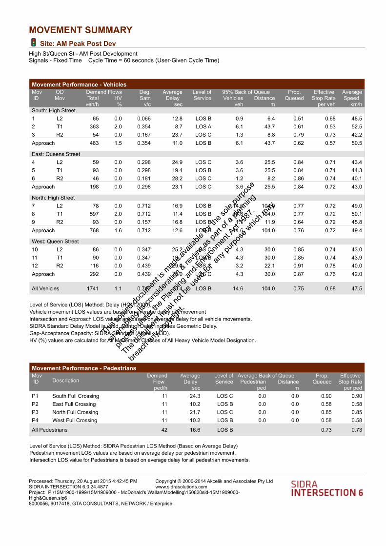
MOVEMENT SUMMARY
Site: AM Peak Post Dev
High St/Queen St - AM Post DevelopmentSignals - Fixed Time Cycle Time = 60 seconds (User-Given Cycle Time)
Movement Performance - Vehicles
Demand Flows 95% Back of QueueMovID
ODMov
Deg.Satn
AverageDelay
Level ofService
Prop. Queued
Effective Stop Rate
AverageSpeed Total HV Vehicles Distance
veh/h % v/c sec veh m per veh km/hSouth: High Street
1 L2 65 0.0 0.066 12.8 LOS B 0.9 6.4 0.51 0.68 48.5
2 T1 363 2.0 0.354 8.7 LOS A 6.1 43.7 0.61 0.53 52.5
3 R2 54 0.0 0.167 23.7 LOS C 1.3 8.8 0.79 0.73 42.2
Approach 483 1.5 0.354 11.0 LOS B 6.1 43.7 0.62 0.57 50.5
East: Queens Street
4 L2 59 0.0 0.298 24.9 LOS C 3.6 25.5 0.84 0.71 43.4
5 T1 93 0.0 0.298 19.4 LOS B 3.6 25.5 0.84 0.71 44.3
6 R2 46 0.0 0.181 28.2 LOS C 1.2 8.2 0.86 0.74 40.1
Approach 198 0.0 0.298 23.1 LOS C 3.6 25.5 0.84 0.72 43.0
North: High Street
7 L2 78 0.0 0.712 16.9 LOS B 14.6 104.0 0.77 0.72 49.0
8 T1 597 2.0 0.712 11.4 LOS B 14.6 104.0 0.77 0.72 50.1
9 R2 93 0.0 0.157 16.8 LOS B 1.7 11.9 0.64 0.72 45.8
Approach 768 1.6 0.712 12.6 LOS B 14.6 104.0 0.76 0.72 49.4
West: Queen Street
10 L2 86 0.0 0.347 25.2 LOS C 4.3 30.0 0.85 0.74 43.0
11 T1 90 0.0 0.347 19.7 LOS B 4.3 30.0 0.85 0.74 43.9
12 R2 116 0.0 0.439 29.0 LOS C 3.2 22.1 0.91 0.78 40.0
Approach 292 0.0 0.439 25.0 LOS C 4.3 30.0 0.87 0.76 42.0
All Vehicles 1741 1.1 0.712 15.4 LOS B 14.6 104.0 0.75 0.68 47.5
Level of Service (LOS) Method: Delay (HCM 2000).
Vehicle movement LOS values are based on average delay per movement
Intersection and Approach LOS values are based on average delay for all vehicle movements.
SIDRA Standard Delay Model is used. Control Delay includes Geometric Delay.
Gap-Acceptance Capacity: SIDRA Standard (Akçelik M3D).
HV (%) values are calculated for All Movement Classes of All Heavy Vehicle Model Designation.
Movement Performance - Pedestrians
Average Back of QueueMovID Description
DemandFlow
AverageDelay
Level ofService
Prop. Queued
Effective Stop RatePedestrian Distance
ped/h sec ped m per ped
P1 South Full Crossing 11 24.3 LOS C 0.0 0.0 0.90 0.90
P2 East Full Crossing 11 10.2 LOS B 0.0 0.0 0.58 0.58
P3 North Full Crossing 11 21.7 LOS C 0.0 0.0 0.85 0.85
P4 West Full Crossing 11 10.2 LOS B 0.0 0.0 0.58 0.58
All Pedestrians 42 16.6 LOS B 0.73 0.73
Level of Service (LOS) Method: SIDRA Pedestrian LOS Method (Based on Average Delay)
Pedestrian movement LOS values are based on average delay per pedestrian movement.
Intersection LOS value for Pedestrians is based on average delay for all pedestrian movements.
Processed: Thursday, 20 August 2015 4:42:45 PMSIDRA INTERSECTION 6.0.24.4877
Copyright © 2000-2014 Akcelik and Associates Pty Ltdwww.sidrasolutions.com
Project: P:\15M1900-1999\15M1909000 - McDonald's Wallan\Modelling\150820sid-15M1909000-High&Queen.sip68000056, 6017418, GTA CONSULTANTS, NETWORK / Enterprise
This co
pied d
ocum
ent is
mad
e ava
ilable
for th
e sole
purpo
se
of en
ablin
g its
cons
iderat
ion &
revie
w as pa
rt of a
plan
ning
proce
ss un
der th
e Plan
ning a
nd E
nviro
nmen
t Act
1987
.
The do
cumen
t mus
t not
be us
ed fo
r any
purpo
se w
hich m
ay
breac
h any
copy
right.

MOVEMENT SUMMARY
Site: PM Peak Post Dev
High St/Queen St - PM Post DevelopmentSignals - Fixed Time Cycle Time = 60 seconds (User-Given Cycle Time)
Movement Performance - Vehicles
Demand Flows 95% Back of QueueMovID
ODMov
Deg.Satn
AverageDelay
Level ofService
Prop. Queued
Effective Stop Rate
AverageSpeed Total HV Vehicles Distance
veh/h % v/c sec veh m per veh km/hSouth: High Street
1 L2 107 0.0 0.108 13.0 LOS B 1.6 10.9 0.52 0.69 48.3
2 T1 797 2.0 0.841 18.7 LOS B 22.9 163.3 0.86 0.90 45.9
3 R2 94 0.0 0.150 16.8 LOS B 1.7 11.8 0.64 0.72 45.8
Approach 998 1.6 0.841 17.9 LOS B 22.9 163.3 0.80 0.86 46.2
East: Queens Street
4 L2 38 0.0 0.240 24.6 LOS C 2.9 20.2 0.82 0.69 43.9
5 T1 85 0.0 0.240 19.0 LOS B 2.9 20.2 0.82 0.69 44.8
6 R2 77 0.0 0.350 31.1 LOS C 2.2 15.1 0.92 0.76 38.8
Approach 200 0.0 0.350 24.8 LOS C 2.9 20.2 0.86 0.72 42.1
North: High Street
7 L2 42 0.0 0.338 14.2 LOS B 5.8 41.1 0.61 0.55 50.8
8 T1 303 2.0 0.338 8.6 LOS A 5.8 41.1 0.61 0.55 52.0
9 R2 63 0.0 0.263 28.0 LOS C 1.6 11.4 0.87 0.75 40.2
Approach 408 1.5 0.338 12.2 LOS B 5.8 41.1 0.65 0.58 49.7
West: Queen Street
10 L2 118 0.0 0.463 26.0 LOS C 5.9 41.6 0.88 0.77 42.6
11 T1 118 0.0 0.463 20.5 LOS C 5.9 41.6 0.88 0.77 43.4
12 R2 110 0.0 0.392 28.6 LOS C 2.9 20.6 0.90 0.78 40.1
Approach 345 0.0 0.463 24.9 LOS C 5.9 41.6 0.89 0.77 42.0
All Vehicles 1952 1.1 0.841 18.6 LOS B 22.9 163.3 0.79 0.77 45.6
Level of Service (LOS) Method: Delay (HCM 2000).
Vehicle movement LOS values are based on average delay per movement
Intersection and Approach LOS values are based on average delay for all vehicle movements.
SIDRA Standard Delay Model is used. Control Delay includes Geometric Delay.
Gap-Acceptance Capacity: SIDRA Standard (Akçelik M3D).
HV (%) values are calculated for All Movement Classes of All Heavy Vehicle Model Designation.
Movement Performance - Pedestrians
Average Back of QueueMovID Description
DemandFlow
AverageDelay
Level ofService
Prop. Queued
Effective Stop RatePedestrian Distance
ped/h sec ped m per ped
P1 South Full Crossing 11 24.3 LOS C 0.0 0.0 0.90 0.90
P2 East Full Crossing 11 10.2 LOS B 0.0 0.0 0.58 0.58
P3 North Full Crossing 11 21.7 LOS C 0.0 0.0 0.85 0.85
P4 West Full Crossing 11 10.2 LOS B 0.0 0.0 0.58 0.58
All Pedestrians 42 16.6 LOS B 0.73 0.73
Level of Service (LOS) Method: SIDRA Pedestrian LOS Method (Based on Average Delay)
Pedestrian movement LOS values are based on average delay per pedestrian movement.
Intersection LOS value for Pedestrians is based on average delay for all pedestrian movements.
Processed: Thursday, 20 August 2015 4:56:25 PMSIDRA INTERSECTION 6.0.24.4877
Copyright © 2000-2014 Akcelik and Associates Pty Ltdwww.sidrasolutions.com
Project: P:\15M1900-1999\15M1909000 - McDonald's Wallan\Modelling\150820sid-15M1909000-High&Queen.sip68000056, 6017418, GTA CONSULTANTS, NETWORK / Enterprise
This co
pied d
ocum
ent is
mad
e ava
ilable
for th
e sole
purpo
se
of en
ablin
g its
cons
iderat
ion &
revie
w as pa
rt of a
plan
ning
proce
ss un
der th
e Plan
ning a
nd E
nviro
nmen
t Act
1987
.
The do
cumen
t mus
t not
be us
ed fo
r any
purpo
se w
hich m
ay
breac
h any
copy
right.
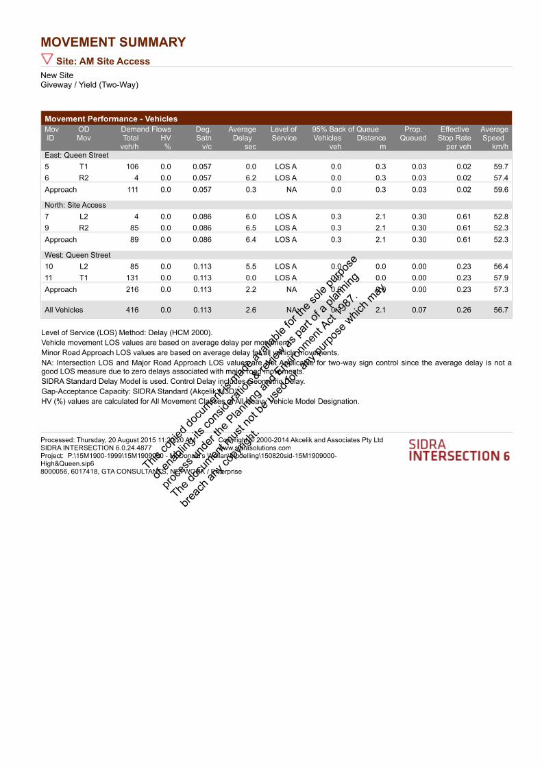
MOVEMENT SUMMARY
Site: AM Site Access
New SiteGiveway / Yield (Two-Way)
Movement Performance - Vehicles
Demand Flows 95% Back of QueueMovID
ODMov
Deg.Satn
AverageDelay
Level ofService
Prop. Queued
Effective Stop Rate
AverageSpeed Total HV Vehicles Distance
veh/h % v/c sec veh m per veh km/hEast: Queen Street
5 T1 106 0.0 0.057 0.0 LOS A 0.0 0.3 0.03 0.02 59.7
6 R2 4 0.0 0.057 6.2 LOS A 0.0 0.3 0.03 0.02 57.4
Approach 111 0.0 0.057 0.3 NA 0.0 0.3 0.03 0.02 59.6
North: Site Access
7 L2 4 0.0 0.086 6.0 LOS A 0.3 2.1 0.30 0.61 52.8
9 R2 85 0.0 0.086 6.5 LOS A 0.3 2.1 0.30 0.61 52.3
Approach 89 0.0 0.086 6.4 LOS A 0.3 2.1 0.30 0.61 52.3
West: Queen Street
10 L2 85 0.0 0.113 5.5 LOS A 0.0 0.0 0.00 0.23 56.4
11 T1 131 0.0 0.113 0.0 LOS A 0.0 0.0 0.00 0.23 57.9
Approach 216 0.0 0.113 2.2 NA 0.0 0.0 0.00 0.23 57.3
All Vehicles 416 0.0 0.113 2.6 NA 0.3 2.1 0.07 0.26 56.7
Level of Service (LOS) Method: Delay (HCM 2000).
Vehicle movement LOS values are based on average delay per movement
Minor Road Approach LOS values are based on average delay for all vehicle movements.
NA: Intersection LOS and Major Road Approach LOS values are Not Applicable for two-way sign control since the average delay is not a good LOS measure due to zero delays associated with major road movements.
SIDRA Standard Delay Model is used. Control Delay includes Geometric Delay.
Gap-Acceptance Capacity: SIDRA Standard (Akçelik M3D).
HV (%) values are calculated for All Movement Classes of All Heavy Vehicle Model Designation.
Processed: Thursday, 20 August 2015 11:20:20 AMSIDRA INTERSECTION 6.0.24.4877
Copyright © 2000-2014 Akcelik and Associates Pty Ltdwww.sidrasolutions.com
Project: P:\15M1900-1999\15M1909000 - McDonald's Wallan\Modelling\150820sid-15M1909000-High&Queen.sip68000056, 6017418, GTA CONSULTANTS, NETWORK / Enterprise
This co
pied d
ocum
ent is
mad
e ava
ilable
for th
e sole
purpo
se
of en
ablin
g its
cons
iderat
ion &
revie
w as pa
rt of a
plan
ning
proce
ss un
der th
e Plan
ning a
nd E
nviro
nmen
t Act
1987
.
The do
cumen
t mus
t not
be us
ed fo
r any
purpo
se w
hich m
ay
breac
h any
copy
right.

MOVEMENT SUMMARY
Site: PM Site Access
New SiteGiveway / Yield (Two-Way)
Movement Performance - Vehicles
Demand Flows 95% Back of QueueMovID
ODMov
Deg.Satn
AverageDelay
Level ofService
Prop. Queued
Effective Stop Rate
AverageSpeed Total HV Vehicles Distance
veh/h % v/c sec veh m per veh km/hEast: Queen Street
5 T1 119 0.0 0.064 0.0 LOS A 0.0 0.3 0.03 0.02 59.7
6 R2 4 0.0 0.064 6.3 LOS A 0.0 0.3 0.03 0.02 57.4
Approach 123 0.0 0.064 0.3 NA 0.0 0.3 0.03 0.02 59.6
North: Site Access
7 L2 4 0.0 0.090 6.1 LOS A 0.3 2.2 0.34 0.63 52.7
9 R2 85 0.0 0.090 6.7 LOS A 0.3 2.2 0.34 0.63 52.2
Approach 89 0.0 0.090 6.7 LOS A 0.3 2.2 0.34 0.63 52.2
West: Queen Street
10 L2 85 0.0 0.135 5.5 LOS A 0.0 0.0 0.00 0.20 56.7
11 T1 174 0.0 0.135 0.0 LOS A 0.0 0.0 0.00 0.20 58.2
Approach 259 0.0 0.135 1.8 NA 0.0 0.0 0.00 0.20 57.7
All Vehicles 472 0.0 0.135 2.3 NA 0.3 2.2 0.07 0.23 57.0
Level of Service (LOS) Method: Delay (HCM 2000).
Vehicle movement LOS values are based on average delay per movement
Minor Road Approach LOS values are based on average delay for all vehicle movements.
NA: Intersection LOS and Major Road Approach LOS values are Not Applicable for two-way sign control since the average delay is not a good LOS measure due to zero delays associated with major road movements.
SIDRA Standard Delay Model is used. Control Delay includes Geometric Delay.
Gap-Acceptance Capacity: SIDRA Standard (Akçelik M3D).
HV (%) values are calculated for All Movement Classes of All Heavy Vehicle Model Designation.
Processed: Thursday, 20 August 2015 11:23:32 AMSIDRA INTERSECTION 6.0.24.4877
Copyright © 2000-2014 Akcelik and Associates Pty Ltdwww.sidrasolutions.com
Project: P:\15M1900-1999\15M1909000 - McDonald's Wallan\Modelling\150820sid-15M1909000-High&Queen.sip68000056, 6017418, GTA CONSULTANTS, NETWORK / Enterprise
This co
pied d
ocum
ent is
mad
e ava
ilable
for th
e sole
purpo
se
of en
ablin
g its
cons
iderat
ion &
revie
w as pa
rt of a
plan
ning
proce
ss un
der th
e Plan
ning a
nd E
nviro
nmen
t Act
1987
.
The do
cumen
t mus
t not
be us
ed fo
r any
purpo
se w
hich m
ay
breac
h any
copy
right.

Melbourne
A Level 25, 55 Collins Street
PO Box 24055
MELBOURNE VIC 3000
P +613 9851 9600
Brisbane
A Level 4, 283 Elizabeth Street
BRISBANE QLD 4000
GPO Box 115
BRISBANE QLD 4001
P +617 3113 5000
Adelaide
A Suite 4, Level 1, 136 The Parade
PO Box 3421
NORWOOD SA 5067
P +618 8334 3600
Townsville
A Level 1, 25 Sturt Street
PO Box 1064
TOWNSVILLE QLD 4810
P +617 4722 2765
Sydney
A Level 6, 15 Help Street
CHATSWOOD NSW 2067
PO Box 5254
WEST CHATSWOOD NSW 1515
P +612 8448 1800
Canberra
A Tower A, Level 5,
7 London Circuit
Canberra ACT 2600
P +612 6243 4826
Gold Coast
A Level 9, Corporate Centre 2
Box 37, 1 Corporate Court
BUNDALL QLD 4217
P +617 5510 4800
F +617 5510 4814
Perth
A Level 27, 44 St Georges Terrace
PERTH WA 6000
P +618 6361 4634
www.gta.com.au www.gta.com.au
This co
pied d
ocum
ent is
mad
e ava
ilable
for th
e sole
purpo
se
of en
ablin
g its
cons
iderat
ion &
revie
w as pa
rt of a
plan
ning
proce
ss un
der th
e Plan
ning a
nd E
nviro
nmen
t Act
1987
.
The do
cumen
t mus
t not
be us
ed fo
r any
purpo
se w
hich m
ay
breac
h any
copy
right.