Embed Size (px)
Citation preview

22-1
SECTION 22
PUBLIC HEALTH APPLICATIONS
OF REMOTE SENSING
by
Charles E. Fuller, D.V.M., M.P.H.Chief, Public Health EcologyPreventive Medicine Division
Medical Research & Operations DirectorateNASA Manned Spacecraft Center
Houston, Texas 77058
INTRODUCTION Cg Rby\g
Since August 1970, a small staff from the Medical Research andOperations Directorate working with the Science & Applications Direc-torate at the Manned Spacecraft Center has studied the feasibility ofusing remote sensing in public health applications. Technical assis-tance to this Public Health Ecology group has been received from theUniversity of Texas School of Public Health at Houston, and from munic-ipal, county, state, and regional government officials. Theoreticalevaluations, and practical applications of remote-sensor data have beendiscussed with representatives from the above groups in addition tothose from the U.S. Public Health Service, the Pan American HealthOrganization, the World Health Organization, and the Food and Agricul-ture Organization of the United Nations. All discussions have beendirected toward potential applications on a pilot study scale.
This Public Health Ecology group has embarked on a three-fold pro-gram of research and development. This overall program entails:
First, a program designed to develop and increase awareness in thePublic Health Sector of the potential of NASA's remote sensing capabil-ities for the solutions of public health problems currently engagingthese agencies.
Second, a program designed to develop and increase a universityand public health sector applied research program into those publichealth problems which might be most amenable to solution by the appli-cation of remote sensing technology.
And third, a program designed to develop and increase an in-housecapability to examine, develop and apply remote sensing applications tothe solutions of public health problems.
https://ntrs.nasa.gov/search.jsp?R=19720021672 2018-06-10T02:39:20+00:00Z

22-2
PROGRAM OBJECTIVES
The Public Health Ecology group is encouraged that it will findsignificant scientific correlations between disease, water, air andurban degradation, and natural disasters as they show relationshipsto other observed phenomenon such as indicator species, crown signa-tures of trees, and evidence of other reliable symbiotic relationships.
Of these four areas of endeavor, animal or insect-borne diseaseshave received the greatest emphasis. These diseases are caused byorganisms whose life cycles depend on insect vectors or animal hoststhat have a unique and often critical dependency on specific componentsof the biosphere for their perpetuation and transmission.
Primary reasons for the stubborn persistence of these diseases inour society lies in our lack of understanding and our inability to dealeffectively with the interrelationships between man and his physical andbiological environment. Remote sensing can provide the investigatorwith the unique perspective and a different kind of knowledge needed todeal more effectively with these diseases.
The key to this sought after new capability is to determine thosehighly reliable sensor detectable characteristics which are to a highdegree mutually exclusive, all inclusive and replicable when addressingvector-borne disease phenomenon or medical zoology problems.
SUPPORTING RESEARCH AND TECHNOLOGY
Contracts to assist in the accomplishment of this work, as seen inFigure 1, have been awarded to the University of Texas School of PublicHealth at Houston. This graduate school, one of eighteen in the nationthat provides Masters and Ph.D. level training to physicians, veteri-narians, dentists, bioenvironmental engineers and other graduate levelparamedical people, has also received a contract to assist the PublicHealth Ecology group in a study of respirable and suspended air-borneparticulates.
The basic technique is dependent on contrast imagery. Since sus-pended particulates scatter light waves of a wavelength equal to thatof the suspended particulate diameter the image contrast at that wave-length is reduced. Furthermore, the amount of reduction of that con-trast has been successfully correlated to the size, size distributionand total weight of suspended particulates in the air environment.Thus, the method requires a passive detector system which will measure

22-3
the amount of scattered light at a particular wavelength or family ofwavelengths and a ground truth capability with which to correlateresults.
The particulate itself may be harmful to the body or may act as acarrier of substances absorbed upon their surface. The capability tomonitor such a hazard would represent a real contribution to communityhealth.
Another study to evaluate the capability of remote sensing indelimiting regions meaningful to urban public health investigators hasbeen initiated at the University of Texas.
This program requires the use of remote sensing to examine thecapability for prediction and assessment of socio-economic spatial dis-tribution and those related ecological facets which exert a marked in-fluence on health and health-related activities.
Another contract was just awarded to the University of Texas Schoolof Public Health to investigate the usefulness of remote sensing imageryto identify and quantify specific water pollution parameters that willcontribute to the resolution of water degradation problems of publichealth importance.
Another contract was recently awarded to the Office of Environmentalstudies, The University of West Florida to conduct an investigation ofthose botanic species or vegetative communities which have a strongrelationship with certain diseases.
PUBLIC HEALTH ECOLOGY PROJECTS
The following specific projects resulting from situations ofopportunity have been initiated in the last seven months.
As the epidemic of Venezuelan equine encephalitis crossed theMexican border and spread through Texas counties in July and August,1971, as seen in Figure 2, NASA provided low and high altitude aerialphotography and health experts trained in remote sensing to a coopera-tive program with the Public Health Service Center for Disease Controland the University of Texas School of Public Health at Houston.
Currently, detailed research is underway to determine the habitatof Culex auinauefasciatus, as seen in Figure 3, the mosquito vector ofSt. Louis encephalitis virus in the Houston area. Studies of thismosquito are indicative that in most cases, as seen in Figure 4, thehabitat can be associated with effluent from septic tank overflow intocollection ditches that are common in the Houston area because of thehigh water table and the soil conditions. These collecting ditches as

22-4
seen in Figure 5, constitute 1600 miles of collecting ditches in HarrisCounty which run into larger ditches as seen in Figure 6, which all runinto Galveston Bay.
NASA aircraft provided thermal scanner data, color infrared, colorand multiband camera coverage over approximately 12 miles of theseditches containing septic water along Little York Road in north Houston.
As seen in Figure 7, ten test sites were surveyed for physical,chemical, microbiological and entomological characteristics at thetime of the flight. This study is still underway.
A project in support of the U.S. Public Health Service Center forDisease Control, Atlanta, Georgia, was initiated in mid-July 1971. Anexplosive outbreak of anthrax caused the death of more than 500 cattleand numerous other animals in Ascension Parish, Louisiana. This appliedresearch project uses remote sensing to determine the environmentalconditions that are conducive to this soil-borne disease outbreak. NASAremote-sensing aircraft have been flown on missions over areas that arehighly endemic for the disease.
Final spatial and numerical mortality data concerning the AscensionParish Anthrax Project in Louisiana has just been received from thePublic Health Service Center for Disease Control in Atlanta. This willbe transferred as overlay information to color coded soils type mapoverlays as seen in Figure 8, to the special purpose semi-controlledcolor infrared mosaic being prepared by the Mapping Sciences Branch.The study has already revealed that essentially no deaths due to anthraxwere observed in soil type 7, seen in orange at the northern part of theparish.
This investigation will permit correlative interpretation of NASAremote-sensing data of farms where anthrax exists. Color and color-infrared aerial photography of the epidemic area is now being analyzedin a retrospective epidemiologic study of this test site. The objectiveis to learn what determinants of anthrax infection can be detected andmeasured from the air so that aircraft may be used to rapidly evaluatepotential for an anthrax outbreak or to determine the natural geographicor physical barriers of an epidemic.
High altitude color infrared aerial photography has been useful toscientists studying the habitat of endemic strains of Venezuelanencephalitis virus as seen in Figure 9, along the southern coast ofFlorida. It has been particularly difficult from the ground to deter-mine the salt-water/fresh-water interface as seen in Figure 10, thatprovides the proper environment for vegetation hammocks in whichencephalitis vector mosquitoes (Culex atratus) commonly breed.
Late in September a low altitude mission was conducted with theNP3A over a 200 acre test plot as seen in Figure 11, between LakesPontchartrain and St. Catherine northeast of New Orleans with color,

22-5
color infrared and multiband sensor and film combinations in a jointinvestigation of the feasibility of using remote sensing to recognizethe ecological set necessary to produce salt marsh mosquito populations.
The New Orleans Mosquito Control Districts three years of baselineentomological, vegetative, aquatic, and meteorological data has showncertain heterogeneous vegetative communities to be empirically butstrongly related to salt marsh mosquito populations. Heterogeneousvegetative communities are even difficult to assess using color infra-red photography as seen in Figure 12.
Major botanical communities in the New Orleans Mosquito ControlDistrict Test Site area have been identified and inventoried and arenow being compared with multiband photography which has been subjectedto edge and color enhancement as a function of emulsion density.
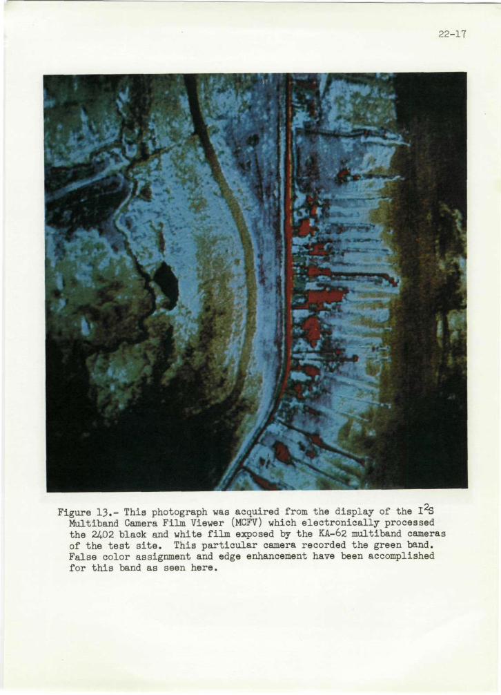
The results of the mission are now being processed by severalinterpretive means. One of these methods is by simultaneously pro-cessing by electronic means three photographic negatives of the sameview which records different wavelength portions of visible light. Theprocess enhances the ease of identifying the different vegetative com-munities and very sharply delineates edge effects and community inter-faces by assigning false colors to differentiate subtle density differ-ences. Figure 13 shows the test site frame in the green band, Figure14 in the red band, and Figure 15, in the near infrared band. As seenin Figure 16, only when the red band and the near infrared band arecombined with decreasing density slices are the most subtle differencesmarkedly observed which reveal even the most minor vegetative communitiesand interface differences.
The importance of this capability is recognized when one observesthat approximately 90 percent of the production of Aedes sollicitansmosquito is dependent on the same ecological set that provides supportfor the Bacopa vegetative community in the New Orleans area.

000ULI
mmqm
ULU
x I'
Z
0
0 m
U
J
Im
0 -
0ZdLU
D
II
LU
la
o~en~
_
.J
00I--
,)
t LLI
I
.
III7I- I .
U)>L
L:r
-.I
-
_IIO
a0_JUI
UL
00I
-'-I
0
'La
I
,o
0H
h
0o 0d
.0
k .0na 04D
0 54
a PC
D0
-I H
5-4.0
0h
ko
-P0
0 D
.00D ,
P 4-4
22-6
mi
00ULL
0
I--JCa-lL
0000L
L
I--
a-
zUm IIIICLU
u)
LU
z0I-LU
zoI-0e zLiuIs
Figure 2.- As the epidemic of Venezuelan equine encephalitis crossed the Mexican border and spread through Texas counties in July and August, 1971, NASA provided low and high altitude aerial photography over a test site in the Flour Bluff section of Corpus Christi, Texas. This activity supported a cooperative program with the Public Health Service Center for Disease Control and the University of Texas School of Public Health at Houston.
COUNTIES WITH CONFIRMED HUMAN
AND EQUINE** CASES OF
VENEZUELAN EQUINE ENCEPHALITIS
TEXAS - JULY-AUGUST 1971
i
i i i
0 100 SCALE OF MILES
\
\
\
^ ̂
t \
COUNTIES WITH CONFIRMED \ ^ / HUMAN AND EQUINE CASES * V ^ r
COUNTIES WITH CONFIRMED HUMAN CASES
COUNTIES WITH CONFIRMED EQUINE** CASES
* * A CONFIRMED EQUINE CASE IS DETERMINED BY EITHER ONE OF THE FOLLOWING: (1) AN ISOLATE FROM AN UN-VACCINATED HORSE IDENTIFIED AS VEE BY THE CF TEST OR (2) AN ISOLATE FROM A VACCINATED HORSE OR FROM ONE WITH AN UNKNOWN VACCINATION HISTORY WHICH WAS IDENTIFIED AS VEE BY THE CF TEST AND PROVEN VIRULENT FOR GUINEA PIGS OR WEANLING MICE
[\3

ro rv> i Oo
Figure 3.- Culex quinquefasciatus is the mosquito vector of St. Louis encephalitis virus in the Houston area. This mosquito which breeds almost entirely in ditches which contain effluent from septic tanks in the Houston area, caused an epidemic of St. Louis encephalitis in 196̂ .. Control of this disease vector is mandatory.

NASA S-71-25437
I
(UMh
Figure J+-- The effluent from septic tanks in thousands of adjacent homes, unable to percolate thru the hard pan, flows thru pipes to openings near these collecting ditches. In this figure we see septic tank effluent running from a pipe opening in front of the trees in the front yard of this house.
ro ro I

-71-38225
ro i
Figure 5.- This collecting ditch is representative of some 1,600 miles of collecting ditches in Harris County. Approximately $900,000 are required each year to find and control Culex quinquefasciatus larvae in Harris County, Houston, Texas.

22-11
tog
Figure 6.- Large ditches such as seen here collect the run off from ditches seen in Figure 5, and channel it to courses which eventually reach Galveston Bay. Culex mosquitoes breed in these larger courses as well as smaller ones provided they contain organic wastes.

22
-12
l!

.22-13
Figure 8.- Color coded soils type map overlays of Ascension Parish, Louisiana, as seen here, as well as mortality, morbidity, soil pH, and soil anthrax organism identification data, will be compared with special purpose semi-controlled infrared mosaics being prepared from data obtained in September 1971, by the NASA NP3A aircraft. This investigation will permit correlative interpretation of NASA remote sensing data with epidemiologic data.
GENERAL SOIL MAP
ASCENSION PARISH L O U I S I A N A
S. DEPARTMENT OF AGRICULTURE
SOIL CONSERVATION SERVICE
ALEXANDRIA. LOUISIANA
JULY 11, 1M1
UMM SOttiOF THI RECENT MtSSUUPPl R O T T O M I A M D
fcUUVIAL lAffOV MftHUM Tt lTURID. »*TTURI
, COMMERCE MHOOM
I COMMERCE MHOON UNOULATIMC
, . N
•.
• • r A • •
A'
• „«*l..,.t..,»t,,U, ;.,»..,.,
P I zt*?y. • j M U4ARKCT LJNDUL*riHC
r — — i MARK IT S - A - F
KJILV 0 * THt LOISSIAL T I t IT AC t
^ ^ M CALMOUM OU- - I I *
; v.V.*.. T,V,, ".
as^sns
IvSHs: l~~~\ i iAMIRETTE I I I R U
• • " tT ALLUVIAL LAHOJ

22-11+
Figure 9.- This color infrared photograph of the south Florida littoral zone acquired at 20,000 meters by NASA remote sensing aircraft readily illustrates the salt water-fresh water influence and interface.
,jNP»»
Figure 10.- The ecotone provided by the interface seen in Figure 9, provides the proper environment for for vegetation hammocks in which encephalitis vector mosquitoes (Culex atratus) commonly breed.

1-72-Ia IM
hck)
SWI Com) Obstructions
wells and pipeline
ft v Alligator Point \^\'
ro ro i H VJl
Figure 11.- The area outlined between Lakes Pontchartrain and St. Catherine includes a 200 acre test site of the New Orleans Mosquito Control District. Three years of baseline entomological, vegetative, aquatic and meteorlogical data has been acquired by that group.

22-16
Figure 12.- This color infrared photograph acquired from ektachrome color infrared 2UU3 film from 770 meters with the NASA NP3A aircraft, illustrates approximately 100 acres of the 200 acre New Orleans Mosquito Control District test site. Several vegetation types can be observed.
22-17
Figure 13.- This photograph was acquired from the display of the 1 % Multlband Camera Film Viewer (MCFV) which electronically processed the 24.02 black and white film exposed by the KA-62 multiband cameras of the test site. This particular camera recorded the green band. False color assignment and edge enhancement have been accomplished for this band as seen here.

22-18
Figure H.- This photograph, acquired by the same means as that seen in Figure 13, was derived from the KA-62 multiband camera that exposed the 2402 film in the red band.

22-19
Figure 15.- This photograph acquired by the same means as that seen in Figures 13 and 14, was derived from the multiband camera that exposed the 24.02 film in the near infrared band.

Figure 16.- This photograph acquired by the same means as the proceeding three, was derived by adding the red and near infrared bands. This process enhances the ease of identifying the different vegetative communities and sharply delineates edge effects and community interfaces by assigning false colors to differentiate subtle density differences.