Embed Size (px)
Citation preview

New York City Department of Transportation
Presented to Community Board 4 Transportation Committee on March 1, 2016
Queens Boulevard 74th St to Eliot Ave
Proposed Corridor Safety Improvements
2016

Operational Project Limits
Operational
Project 3
Operational
Project 2: 2016
Operational
Project 1: 2015
DOT continues to work
with CB2 and monitor
area for potential issues,
including traffic delays
and safety conditions
2

• October 2015: Introduction and Workshop Notification to Community Board 4 Full Board
• November 2015: Operational Project 2 Safety Workshop
• February 2016: Briefing with Queens Center Mall
• March 2016: Briefing with Elected Officials
• March 2016: Presentation to Community Board 4 Transportation Committee
• March 2016: Briefing to Community Board 4 Full Board
• April 2016: Presentation to CB4 Full Board and vote
• June 2016: Proposed Operational Project 2 Implementation Start
• FY18: Great Streets Capital Construction Phase 1 Start
Project Timeline
3

Operational Project 2: 74th St to Eliot Ave
Queens
Center
Mall
2016 Project Limits
M
R
Queens
Place Mall
4

Vision Zero Priority
Queens Pedestrian Safety Action Plan: Priority Map
2016 Limits
• Queens Blvd (7.2 miles):
• Vision Zero Priority Corridor with
19 total and 12 pedestrian fatalities
(2010-2014)
• Queens Blvd – 74th St to Eliot Ave
(1.2 miles):
• 4 Vision Zero Priority Intersections:
• Albion Ave
• Broadway/Grand Ave
• 55th Ave
• Woodhaven Blvd/59th Ave
• Fatalities: 5 total and 4 pedestrian
(2010 – present)
5

Safety Data – 74th St to Eliot Ave
Total
injuries
2010-2014
Severe
Injuries
+ Fatalities*
2010-2014
21 pedestrian KSI (killed or severely injured)
is twice as high as rest of Queens Blvd
with service road geometry
Majority of pedestrians (54%) hit at intersections, while
crossing with the signal
• Only 22% hit crossing against the signal
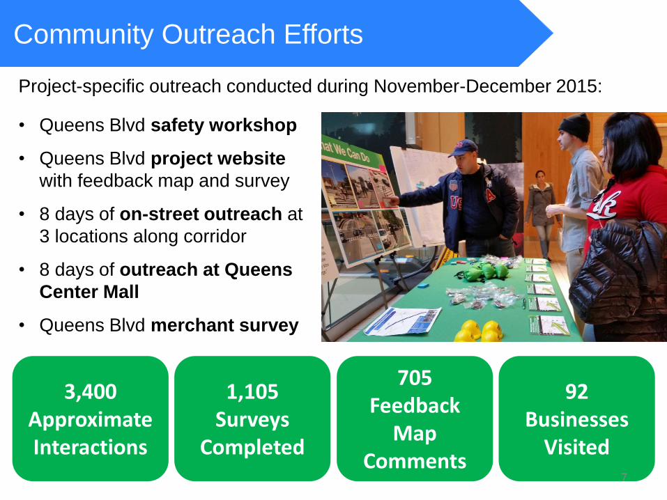
Community Outreach Efforts
Project-specific outreach conducted during November-December 2015:
• Queens Blvd safety workshop
• Queens Blvd project website
with feedback map and survey
• 8 days of on-street outreach at
3 locations along corridor
• 8 days of outreach at Queens
Center Mall
• Queens Blvd merchant survey
3,400 Approximate Interactions
1,105 Surveys
Completed
92 Businesses
Visited
705 Feedback
Map Comments
7
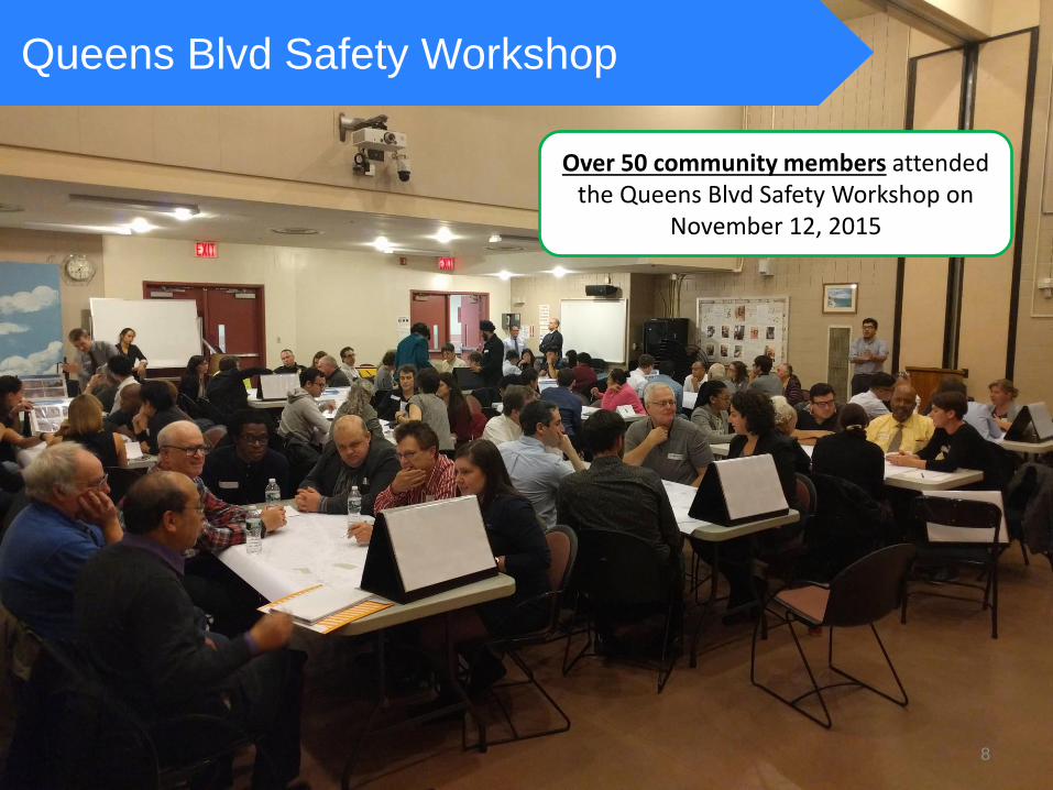
Queens Blvd Safety Workshop
Over 50 community members attended the Queens Blvd Safety Workshop on
November 12, 2015
8
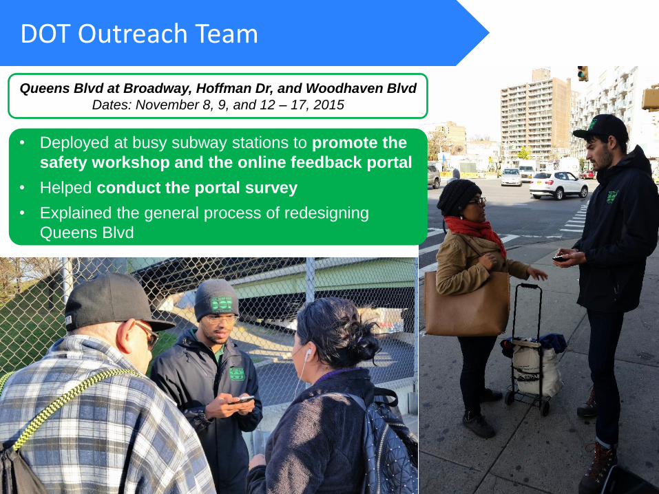
DOT Outreach Team
• Deployed at busy subway stations to promote the
safety workshop and the online feedback portal
• Helped conduct the portal survey
• Explained the general process of redesigning
Queens Blvd
Queens Blvd at Broadway, Hoffman Dr, and Woodhaven Blvd
Dates: November 8, 9, and 12 – 17, 2015

Proposal
DOT Outreach Team
Visited all the businesses along the project
corridor to ask about commercial delivery
patterns, double-parking observations, and
basic background information
Queens Blvd Merchant Survey
Date: December 14, 2015

Proposal
DOT Outreach Team
• Received 631 map
comments supporting
street improvements
• Conducted 632 origin/
destination surveys
Queens Center Mall
Dates: December 6 –13, 2015

www.nycdotfeedbackportals.nyc/queens-blvd
74 map comments 473 surveys completed
Queens Blvd website included:
• Interactive feedback map
• User survey
• Project and outreach updates
Queens Blvd Project Website
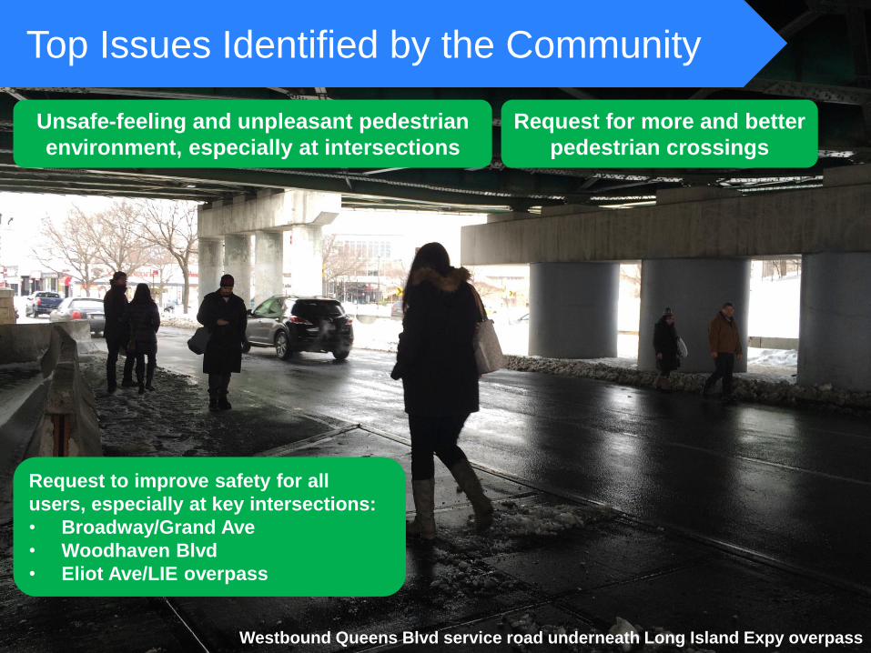
Top Issues Identified by the Community
Request to improve safety for all
users, especially at key intersections:
• Broadway/Grand Ave
• Woodhaven Blvd
• Eliot Ave/LIE overpass
Westbound Queens Blvd service road underneath Long Island Expy overpass
Unsafe-feeling and unpleasant pedestrian
environment, especially at intersections
Request for more and better
pedestrian crossings

Top Issues Identified by the Community
Westbound Queens Blvd at Albion Ave, looking west
Requests for continuation
of 2015 project
Unsafe-feeling and
uncomfortable to bike
Over 250 cyclists using
Queens Blvd per day (data collected 7a-7p July 2015)

Buses are often blocked by taxis and other
vehicles from pulling over curbside at bus
stops forcing passengers into the street
Westbound Queens Blvd in front of Queens Center Mall, looking east
Top Issues Identified by the Community
Misuse of service roads and curb,
especially near the malls

Design Principles / Project Goals
1. Calm the service roads
2. Keep main line moving (preserve existing lanes)
3. Accommodate all road users and enhance the sense of place
4. Reduce roadway shopping
16

Design Principles / Project Goals
5. Design based on crash history
6. Complete pedestrian network and connect neighborhoods
7. Eliminate highway-like design features
17

Key Design Features Continue 2015 design with
pedestrian path and bike
lane along medians
18

Key Design Features: Stop-Controlled Transition
Continue use of
stop right /left
turn at transitions
within 2016 limits
Before
After
Outreach Finding:
More drivers use slips
to switch back and
forth to fastest moving
travel lanes than for
access to side streets
and local businesses
Safer for
drivers,
cyclists, and
pedestrians
At some
locations,
daylight for
safe turns
19

Benefits of Stop-Controlled Transition Lane
Stop-controlled transition lanes
create safer transition points
and allow for continuation of
pedestrian and bicycle path
Turns between mainline and service
road prohibited at intersections
Shifting transitions to intersections
(like at Eastern and Ocean Pkwys)
increases conflicts for all users and
potentially increases crashes
Existing movements
Additional movements
if transitions allowed
at intersections
20
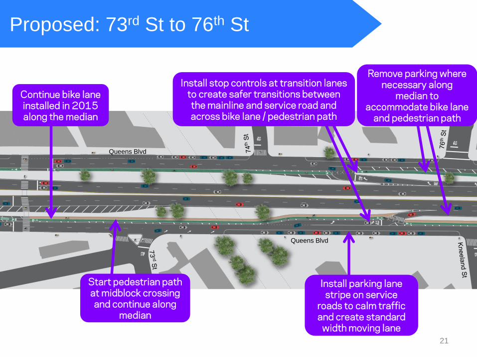
Proposed: 73rd St to 76th St
Install parking lane stripe on service
roads to calm traffic and create standard
width moving lane
Start pedestrian path at midblock crossing and continue along
median
Continue bike lane installed in 2015 along the median
Install stop controls at transition lanes to create safer transitions between the mainline and service road and across bike lane / pedestrian path
Remove parking where necessary along
median to accommodate bike lane
and pedestrian path
Queens Blvd
Queens Blvd
21

Proposed: Albion Ave/Hillyer St
Close low volume transition lane close
to intersection to reduce conflicts
Extend median tips with paint to shorten crossing
distances and expand pedestrian refuge
Install mall-to-mall crosswalks to expand pedestrian network
and visually tighten wide intersections
Remove underutilized meters for half block between Hillyer
St and 51st Ave and convert to regular on-street parking
Queens Blvd
Queens Blvd
Alb
ion A
ve
22
8
67

Proposed: 51st Ave
Install stop control on transition
Extend median tips and adjust
crosswalks
Extend left turn bay to prevent vehicles making left turns from blocking
through traffic
Install stop control on transition
Install mall-to-mall crosswalks
Queens Blvd
Queens Blvd
Remove underutilized meters between Codwise Pl and Goldsmith St and
convert to regular on-street parking
23
3 65

Proposed: Van Loon St – Broadway/Grand Ave
Install stop
control on transition
Install mall-to-mall crosswalks
Install right turn lane and install Leading Pedestrian
Interval (LPI) for north crosswalk to give
pedestrians a head start
Add parking on north curb between
Reeder St and Van Loon St (currently No
Standing Anytime)
Extend median
tips
Remove capacity on service roads
east of Broadway to calm traffic and reduce speeding
Install painted
curb extension
Queens Blvd
Queens Blvd
Ban low volume, redundant left turns from Queens Blvd onto Van Loon St to
reduce conflict at a narrow intersection and expand pedestrian refuge
Peak hour volume: 53 (EB), 37 (WB) 24
5
100
1 34

Proposed: 55th Ave – 57th Ave
Install stop control on transitions
Install mall-to-mall crosswalk on south
side at 57th Ave
Mark two lanes on eastbound service road to separate vehicles
continuing on Queens Blvd and vehicles turning onto Hoffman Dr
Pedestrian path stops at
57th Ave
Expand pedestrian space around island to shorten crossing
distance
Extend median tips and install mall-to-
mall crosswalks
25
2 87
4
56
3 51

Proposed: 90th St – Woodhaven Blvd
Signalize and install right turn lane to 90th St and install
painted curb extensions to create safer pedestrian crossing
Ban left turn from eastbound Queens Blvd
onto northbound Woodhaven Blvd
(peak hour volume: 115)
Move taxi stand between 90th St
and 57th Ave
Signalize transition from mainline to service road
to accommodate high volumes crossing bike
lane to service road
Install stop control for
transition to mainline
Install two-way bike lane on overpass
connecting eastbound and westbound lanes
(without removing lanes on Woodhaven)
Bike lanes continue against both medians to Woodhaven Blvd
Queens Blvd
Woodhaven B
lvd
59
th A
ve
Queens Center Mall
26
9 174
Install BUS ONLY markings for bus
stop in front of mall

Proposed: Woodhaven Blvd – Eliot Ave
Expand pedestrian space
on overpass
Continue bike lane via two-way path on eastbound service road that accommodates cyclists without removing
lanes at westbound approach to Woodhaven Blvd
Install pedestrian
actuated signal at entrance ramp to LIE
Install sharrows and bicycle markings to direct
cyclists to two-way path on eastbound service road
Install new crosswalks on west side of Eliot Ave to
accommodate pedestrian desire line
Install new crosswalk to create shorter,
more direct crossing
Install painted space with granite blocks
under LIE overpass to allow pedestrians and cyclists to more easily
cross Queens Blvd
Woodhaven B
lvd
59
th A
ve
27
2 23
Sub
way

Metered parking on curb
Free parking on median (between 74th St
and Broadway)
• Street cleaning along median 6:30-7am
everyday except Sunday
Findings from parking study:
• Few vehicles park on Queens Blvd
overnight
• Same vehicles are parked all day along
median (very little turnover during
school/business hours)
• Curbside metered parking underutilized
Free parking on
median vs metered
parking on curb
No vehicles park on
median overnight
Parking Usage Study
28

Parking Changes
19 spaces
Only 50% of median in this section
has parking spaces
Existing Median Parking Regulations:
Red = no existing parking spaces
Green = existing parking spaces
29
Parking changes are limited to
west of Broadway/Grand Ave

19 spaces
Create +50 free parking
spaces along curb
+10 spaces Currently: No Standing Anytime
+20 spaces Currently: Metered parking
+10 spaces Currently: Metered parking
+10 spaces Currently: Construction
30
138 – 50 = 88 net loss Parking changes do not fully eliminate
available spaces:
• Median only has daytime demand
• Very little turnover on median
• Significant available curbside space
Parking Changes

Benefits of Safety Proposal
• Calm service roads and reduce speeding
• Expand pedestrian network and shorten
crossing distances
• Allow for safe, convenient bicycle travel
• Creates predictable movements
Pedestrian Path and Bicycle Lane
Median Tips and Mall-to-Mall Crossings
• Shorten crossing distances
• Create new crossings
• Visually tighten wide intersections
• Allow for safer vehicle transitions between
mainline and service road
• Allow for pedestrian path and bike lane
• Reduce highway-like feel
Stop-Controlled Transition Lanes
31
Before: Queens Blvd at 58th St
After: Queens Blvd at 58th St

Benefits of Safety Proposal
• Replaces underutilized
meters with free on-street
parking
• Adds additional curbside
parking where possible
• Discourages vehicles from
blocking buses
Bus Stop Markings at
Woodhaven Blvd
Parking Changes
Traffic Signals and Timing
Changes
• Provide safer pedestrian
crossings
32
After: Queens Blvd at 50th St
After After: Queens Blvd at 59th St

www.nyc.gov/dot Thank
You
Contact: Queens Borough Commissioner’s Office at 212-839-2510 or [email protected]