Embed Size (px)
Citation preview
Terms of Reference for an Environmental Impact Statement
Queensland Curtis LNG Project (QCLNG)
Released: Under Part (4) of the Queensland State Development and Public Works Organisation Act 1971 And Under Part 8 of the Commonwealth Environment Protection and Biodiversity Conservation Act 1999
Terms of Reference – Queensland Curtis LNG Project (QCLNG) ii
Table of Contents ABBREVIATIONS........................................................................................................................................ 1
PREFACE..................................................................................................................................................... 3
1. PROJECT BACKGROUND ..................................................................................................................... 3
2. THE PROJECT .................................................................................................................................... 3
3. THE PROPONENTS ............................................................................................................................. 6
4. ADMINISTRATIVE PROCEDURES FOR THESE TERMS OF REFERENCE....................................................... 6
5. CONSULTATION ON THE TERMS OF REFERENCE .................................................................................. 8
PROPOSED DEVELOPMENT AREAS..................................................................................................... 10
PART A—INFORMATION AND ADVICE ON PREPARATION OF THE EIS........................................... 11
1 INTRODUCTION ................................................................................................................................ 11
2 EIS OBJECTIVE ................................................................................................................................ 11
3 GENERAL EIS GUIDELINES ............................................................................................................... 12
4 STAKEHOLDER CONSULTATION ......................................................................................................... 14
5 GENERAL EIS FORMAT..................................................................................................................... 15
PART B—SPECIFIC REQUIREMENTS: CONTENTS OF THE EIS......................................................... 15
EXECUTIVE SUMMARY................................................................................................................................ 15
GLOSSARY OF TERMS................................................................................................................................ 16
1 INTRODUCTION..................................................................................................................................... 16
1.1 PROJECT PROPONENT...................................................................................................................... 16
1.2 PROJECT DESCRIPTION .................................................................................................................... 16
1.2.1 Relationship to other projects ............................................................................................... 16
1.3 PROJECT OBJECTIVES AND SCOPE .................................................................................................... 17
1.4 PROJECT NEED, COSTS AND BENEFITS .............................................................................................. 17
1.4.1 Need for the project .............................................................................................................. 17
1.4.2 Costs and benefits of the project .......................................................................................... 17
1.5 ALTERNATIVES TO THE PROJECT....................................................................................................... 17
1.6 THE ENVIRONMENTAL IMPACT ASSESSMENT PROCESS ....................................................................... 18
1.6.1 Methodology of the EIS ........................................................................................................ 18
1.6.2 Objectives of the EIS ............................................................................................................ 18
1.6.3 Submissions.......................................................................................................................... 18
1.7 PUBLIC CONSULTATION PROCESS ..................................................................................................... 18
1.8 PROJECT APPROVALS ...................................................................................................................... 19
1.8.1 Relevant legislation and policy requirements ....................................................................... 19
1.8.2 Planning process and standards .......................................................................................... 20
Terms of Reference – Queensland Curtis LNG Project (QCLNG) iii
1.9 ACCREDITED PROCESS FOR CONTROLLED ACTIONS UNDER COMMONWEALTH LEGISLATION ................. 21
2 DESCRIPTION OF THE PROJECT........................................................................................................ 23
2.1 LOCATION........................................................................................................................................ 23
2.1.1 Regional context ................................................................................................................... 23
2.1.2 Local context......................................................................................................................... 23
2.2 CONSTRUCTION............................................................................................................................... 24
2.2.1 LNG facility construction ....................................................................................................... 24
2.2.2 Gas transmission pipeline construction ................................................................................ 28
2.2.3 Coal seam gas field expansion construction activities ......................................................... 30
2.3 OPERATION ..................................................................................................................................... 31
2.4 REHABILITATION AND DECOMMISSIONING .......................................................................................... 32
2.4.1 Coal seam gas field .............................................................................................................. 32
2.4.2 Gas transmission pipeline..................................................................................................... 32
2.4.3 LNG facility ............................................................................................................................ 32
2.5 INFRASTRUCTURE REQUIREMENTS.................................................................................................... 32
2.5.1 Energy.................................................................................................................................. 33
2.5.2 Water supply and management............................................................................................ 33
2.5.3 Transport............................................................................................................................... 35
2.5.4 Workforce and accommodation............................................................................................ 36
2.5.5 Telecommunications............................................................................................................. 37
2.5.6 Stormwater and Sewerage ................................................................................................... 37
2.5.7 Air and noise emissions........................................................................................................ 38
2.6 WASTE MANAGEMENT ...................................................................................................................... 38
2.6.1 Solid waste disposal ............................................................................................................. 38
2.6.2 Liquid waste .......................................................................................................................... 38
3. ENVIRONMENTAL VALUES AND MANAGEMENT OF IMPACTS..................................................... 40
3.1 CLIMATE.......................................................................................................................................... 42
3.2 LAND............................................................................................................................................... 43
3.2.1 Topography and geomorphology.......................................................................................... 43
3.2.2 Geology and Soils................................................................................................................. 43
3.2.3 Land use and infrastructure .................................................................................................. 45
3.2.4 Visual amenity....................................................................................................................... 47
3.2.5 Land contamination .............................................................................................................. 49
3.3 NATURE CONSERVATION .................................................................................................................. 49
3.3.1 Sensitive environmental areas.............................................................................................. 51
Terms of Reference – Queensland Curtis LNG Project (QCLNG) iv
3.3.2 Terrestrial flora...................................................................................................................... 53
3.3.3 Terrestrial fauna.................................................................................................................... 56
3.3.4 Aquatic flora and fauna......................................................................................................... 57
3.3.5 Marine Flora and Fauna ....................................................................................................... 59
3.4 WATER RESOURCES ........................................................................................................................ 61
3.4.1 Surface waterways and groundwater ................................................................................... 61
3.4.2 Coastal environment............................................................................................................. 65
3.5 AIR ................................................................................................................................................. 67
3.5.1 Greenhouse gas emissions .................................................................................................. 71
3.5.2 Greenhouse gas abatement....................................................................................................... 72
3.5.3 Climate change adaptation ...................................................................................................... 73
3.6 NOISE AND VIBRATION...................................................................................................................... 73
3.7 WASTE............................................................................................................................................ 75
3.7.1 Waste generation.................................................................................................................. 75
3.7.2 Waste management.............................................................................................................. 75
3.8 TRANSPORT .................................................................................................................................... 76
3.8.1 Transport methods and routes.............................................................................................. 76
3.8.2 Road infrastructure alterations.............................................................................................. 80
3.9 CULTURAL HERITAGE ....................................................................................................................... 80
3.9.1 Indigenous Cultural heritage................................................................................................. 80
3.9.2 Non-Indigenous cultural heritage.......................................................................................... 80
3.10 CUMULATIVE IMPACTS.................................................................................................................. 82
4. SOCIAL VALUES AND MANAGEMENT OF IMPACTS .................................................................... 83
Community health and safety.............................................................................................................. 84
5. IMPACTS ON STATE AND LOCAL ECONOMIES AND MANAGEMENT OF THOSE IMPACTS...... 86
6. HAZARD AND RISK.............................................................................................................................. 87
Hazard and risk assessment............................................................................................................... 87
Emergency management plan ............................................................................................................ 89
7. ENVIRONMENTAL MANAGEMENT PLANS........................................................................................ 90
8. CONCLUSION AND RECOMMENDATIONS........................................................................................ 91
9. REFERENCES....................................................................................................................................... 91
10. RECOMMENDED APPENDICES........................................................................................................ 92
10.1 FINAL TERMS OF REFERENCE FOR THIS EIS .................................................................................. 92
10.2 CROSS- REFERENCE WITH TERMS OF REFERENCE ......................................................................... 92
10.3 DEVELOPMENT APPROVALS.......................................................................................................... 92

Terms of Reference – Queensland Curtis LNG Project (QCLNG) v
10.4 STUDY TEAM ............................................................................................................................... 92
10.5 CONSULTATION REPORT .............................................................................................................. 92
10.6 TECHNICAL DATA AND BASELINE STUDIES...................................................................................... 92
10.7 LIST OF PROPONENT COMMITMENTS ............................................................................................. 93
10.8 EPBC ACT REPORT..................................................................................................................... 93
Terms of Reference – Queensland Curtis LNG Project (QCLNG) 1
Abbreviations The following abbreviations have been used in this document:
ACH Act Aboriginal Cultural Heritage Act 2003 (Qld)
AHD Australian height datum
CAMBA China-Australia Migratory Bird Agreement
ANZECC Australian and New Zealand Environment and Conservation Council
GPC Gladstone Ports Corporation
CHMP Cultural Heritage Management Plan
CO2 Carbon dioxide
CG The Coordinator-General of the State of Queensland
CSG Coal seam gas
CQSS2 Central Queensland Strategy for Sustainability – 2004 and Beyond
DEEDI Qld Department of Employment, Economic Development & Innovation
DERM Qld Department of the Environment & Resource Management
DEWHA Australian Department of Environment, Water, Heritage and the Arts
DLGSR Queensland Department of Local Government, Sport and Recreation
DIP Queensland Department of Infrastructure and Planning
DME Former Qld Department of Mines and Energy – now part of DEEDI
DMR Former Qld Department of Main Roads – now part of DTM
DNRW Former Qld Department of Natural Resources and Water – now part of DERM
DPI&F Former Qld Department of Primary Industries and Fisheries – now part of DEEDI
DTM Qld Department of Transport & Main Roads
EIS Environmental Impact Statement, as defined by Part 4 of the State Development and Public Works Organisation Act 1971
EMP Environmental management plan
EP Act Environmental Protection Act 1994 (Qld)
Terms of Reference – Queensland Curtis LNG Project (QCLNG) 2
EPA Former Qld Environmental Protection Agency – now part of DERM
EPBC Act Environment Protection and Biodiversity Conservation Act 1999 (Cth)
EPP Environmental Protection Policy
EPSD Commonwealth Environment Protection (Sea Dumping) Act 1981
ERA Environmentally relevant activity
GQAL Good Quality Agricultural Land in State Planning Policy 1/92: Development and the Conservation of Agricultural Land.
IAS Initial Advice Statement, as defined by Part 4 of the State Development and Public Works Organisation Act 1971
IPA Integrated Planning Act 1997 (Qld)
JAMBA Japan-Australia Migratory Bird Agreement
LAT Lowest Astronomical Tide
Mtpa Million tonnes per annum
MNES Matters of National Environmental Significance
NCA Nature Conservation Act 1992 (Qld)
NODGDM National Assessment Guidelines for Dredging (2009)
NOx Oxides of nitrogen
NTRB Native Title Representative Body
QCLNG project Queensland Curtis LNG Project
SDPWO Act State Development and Public Works Organisation Act 1971 (Qld)
SPP 1/03 State Planning Policy 1/03 Mitigating the Adverse Impacts of Flood, Bushfire and Landslide
TAL Tonnes axle loading
ToR Terms of Reference as defined by Part 4 of the State Development and Public Works Organisation Act 1971
Terms of Reference – Queensland Curtis LNG Project (QCLNG) 3
Preface 1. Project background Queensland has abundant coal seam gas resources which have been developed to supply fuel for domestic power generation. With increasing reserves being proven the potential to supply gas to the export market in the form of Liquefied Natural Gas (LNG) has developed and a number of companies are examining the potential to liquefy coal seam gas for shipment overseas. Queensland Gas Company Limited (QGC) is proposing to develop a Liquefied Natural Gas (LNG) export facility at Gladstone in Central Queensland, Australia. The facility will allow QCLNG to commercialise QGC’s Surat Basin coal seam gas (CSG) resources. Phase 1 of the Project will construct a facility to produce three to four million tonnes per annum (Mtpa) of LNG, with the potential for future expansion to twelve Mtpa. The facility will be developed on Curtis Island (in the North China Bay area) which lies within the Gladstone Ports limits. The North China Bay site is in close proximity to the industrial deepwater berths in the port of Gladstone1. The project will source gas from QGC’s CSG fields around the Miles area of the Surat Basin, with gas being transported to the Curtis Island LNG facility via a subsurface 380 km gas transmission pipeline(s).
2. The project The project is predicted to cost approximately A$8 billion for Phase 1 and to generate at the peak of the four year construction period approximately 3600 jobs and sustain around 820 jobs during operation. The project will consist of the following key components:
• CSG field development–expansion of fields by two sets of around 1500 wells
• gas transmission pipeline construction–a network in the Surat Basin, a collector pipeline to the Fairview area for a third train, and a transmission pipeline to Gladstone
• LNG liquefaction and export facility development for three trains on Curtis Island.
The QCLNG project will consist of: • Project Infrastructure – to be developed by the proponent; and • Ancillary Infrastructure – to be developed by other parties.
Project infrastructure is as follows with the EPBC referral numbers referenced; Coal seam gas field development (EPBC 2008/4398) QGC Limited owns and operates a number of CSG fields in the Miles area with a development program to have approximately 250 operating wells supplying the domestic market by 2010. These fields and further lateral extensions will be developed and expanded to provide sufficient gas supply to the LNG facility. To accommodate this gas demand, existing gas field activities will require significant expansion of well development, in-field compression, processing plant, associated water management, land access and ancillary infrastructure. Integral to this field development is the investigation of environmentally2, economically and socially responsible water processing and beneficial 1 Maritime Safety Queensland 2 DERM (EPA)
Terms of Reference – Queensland Curtis LNG Project (QCLNG) 4
reuse options for the associated water. The project will require approximately 600 production wells by the end of 2013 and up to 1500 wells over the minimum 20-year operation of the project for the first LNG train. The second LNG train will require an additional 1500 wells to be added over the life of the Project. The lateral pipeline to the Fairview area which is part of this Project will act as a collector for gas from fields in that area.
In addition to operationally related infrastructure, the EIS should consider the impact on environmental values of all exploration activities relating to the expansion of the CSG field such as drilling of appraisal wells, collection and flaring of gas, and associated water management3. Gas transmission corridor and pipeline (EPBC 2008/4399) A 380km main pipeline will link the QGC gas fields to the LNG plant, sized to ultimately supply gas for three LNG trains but with an initial capability of transporting 600 terajoules per day (TJ)/day (TJ = 1012 J) of gas to supply the first LNG train. The design for the full three-train capacity in the pipeline will be provided by larger diameter sections, looping (doubling sections of the line in constricted areas) or other measures to supply gas for 12 Mtpa LNG production.
The transmission pipeline crossing from the mainland4 to Curtis Island will consider a range of crossing locations and installation techniques including horizontal directional drilling, laying the pipe on the seabed or in a trench in the seabed. The Queensland Government is currently undertaking a Corridor Study with a possible State Development Area being declared for a pipeline route into the Curtis Island LNG precinct. The aim will be to optimise the land utilisation and minimise disruption to the industrial area. The EIS will consider this study in determining pipeline routes for the QCLNG project pipeline. LNG liquefaction and export facility (EPBC 2008/4402) The proposed 3 train LNG facility will be located on Curtis Island in the North China Bay area, which is situated approximately 5 km north-east of the City of Gladstone. The LNG facility components may include, but are not limited to:
• metering
• inlet separation / filtration / treatment to remove pipeline debris and liquids
• gas treatment to remove major components within the gas stream that are detrimental to the process of liquefaction of natural gas, including carbon dioxide, water and other contaminants
• up to three refrigeration and liquefaction trains
• LNG storage tank(s) with vapour recovery
• utilities including water, fuel systems, control systems and power generation
3 DERM (EPA) 4 Maritime Safety Queensland
Terms of Reference – Queensland Curtis LNG Project (QCLNG) 5
• flares including a plant flare, tank flare, and/or jetty flare
• marine facilities including a LNG tanker loading jetty and operations wharves at Gladstone and Curtis Island to be used for construction and operations purposes
• supporting facilities (e.g. construction accommodation, and roads ).
Ancillary infrastructure In addition to the project infrastructure developed by the proponent, the QCLNG project may also require development of several components of ancillary infrastructure which may be constructed and operated by parties other than the Proponent. Separate approval processes and environmental impact statements are already being undertaken for these ancillary components or may ultimately be undertaken by other parties separately from this EIS. These ancillary infrastructure may include:
• options for construction and operations access from Gladstone to Curtis Island
• development of shipping channels, swing basins and berth pockets for use by LNG ships (EPBC 2008/4406)
• developments and infrastructure for the beneficial use of associated water produced from the gas field development
Access (construction and operations) to Curtis Island Options for access to Curtis Island for construction and operations of the LNG liquefaction and export facility include:
• a bridge linking Curtis Island (Laird Point area) with the mainland (Friend Point area) (EPBC 2008/4400) and a new access road on the western side of Curtis Island (EPBC2008/4404), as well as on the mainland linking the bridge (EPBC 2008/4403) with the existing regional road network. The development of bridge and roads infrastructure is currently being proposed to be undertaken by Santos Limited and is detailed in its EIS for the Gladstone LNG Project (GLNG) which has been lodged with the Queensland Government.
• marine barge and ferry operations operating between purpose-built terminals at Gladstone and at Curtis Island.
Shipping Channel, Swing Basin & Berths The operation of the LNG liquefaction and export facility will also require dredging of berths and a swing basin adjacent the export jetty (EPBC 20084401) and a new shipping channel to connect it to the existing Targinnie channel in Gladstone Harbour (EPBC 2008/4406). The development of this infrastructure is currently being proposed to be undertaken by the Gladstone Ports Corporation (GPC). The GPC lodged an Initial Advice Statement and proposes to undertake an EIS for its Western Port Strategic Dredging and Disposal Project which includes the development of berths, a swing basin and the channel extension to be utilised by the QCLNG project. Other Beneficial Water Use Developments This ToR for the EIS requires the proponent to describe options for and to assess the production, storage treatment and potential beneficial use options for the associated water produced from the gas field development.
Terms of Reference – Queensland Curtis LNG Project (QCLNG) 6
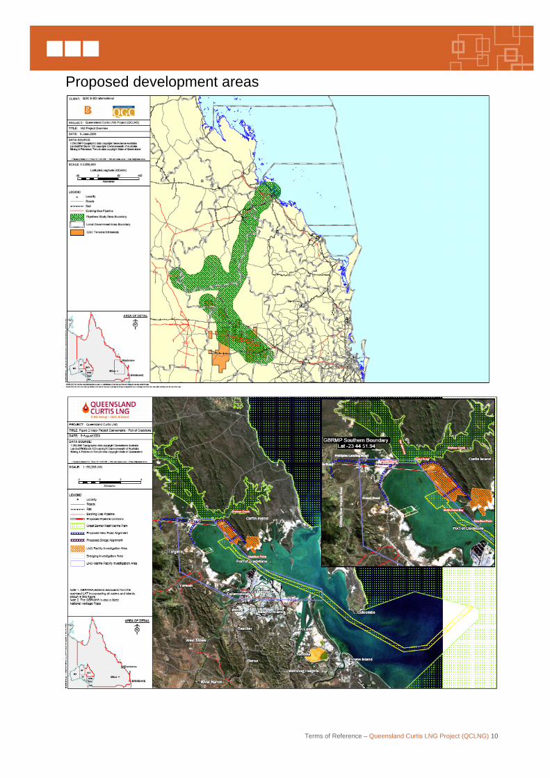
However, there are a number of options for beneficial use of the water. Other options involving the potential commercial beneficial use of the associated water which involve ancillary infrastructure or developments outside the project scope are not detailed in these terms of reference. Should projects be proposed by the proponent or other parties utilising the associated water for alternative beneficial uses, these projects and infrastructure will be subject to environmental and planning approval requirements outside and separate to the EIS for the QCLNG project. A map of the proposed development areas is shown at the end of this preface.
3. The proponent The proponent for the Queensland Curtis LNG Project (QCLNG) is Queensland Gas Company Limited (QGC). QGC is a wholly owned subsidiary of the BG Group plc (BG) following a successful merger with BG’s Australian operating company BG International Limited earlier this year.
BG is a top-10 publicly listed company on the London Stock Exchange with a market capitalisation of more than £41.5 billion (A$85.3 billion), as of June 2008. BG operates worldwide throughout the gas supply chain in exploration and production, power, transmission and distribution, and LNG, and has interests in 27 countries. In 2007, BG sold more than 3.5 million tonnes of LNG into the Asia-Pacific market and BG has recently been selected by the Energy Market Authority of Singapore to supply up to 3 million tonnes per annum of LNG to the Singaporean market for a period of up to 20 years.
The acquisition of QGC by BG provides BG with an integrated energy company in Australia combining QGC’s gas exploration, production and electricity generation assets with BG’s international experience and expertise in LNG development, marketing, shipping and sales. Following the further acquisition of interests in Roma Petroleum, Victoria Petroleum and Pure Energy by BG and their integration into QGC, it currently leases over 7500 km2 in the gas-rich Surat Basin and has long-term contracts to supply growing volumes of coal seam gas to the domestic market.
4. Administrative procedures for these terms of reference On 3 June 2008, the proponent prepared and lodged an initial advice statement (IAS) for the project with the Coordinator-General (CG). The IAS provides an outline of the proposed project, including the project rationale and its potential impacts. On 4 July 2008, the CG declared the project to be a ‘significant project for which an EIS is required’, pursuant to s.26 (1) (a) of the State Development Public Works Organisation Act 1971 (SDPWO Act). Matters considered by the CG in making this declaration included information in the initial advice statement (IAS) prepared by QGC, the level of investment necessary for the project, employment opportunities provided by the project, potential impacts on the environment, potential effects on relevant infrastructure and the significance of the project to the region and state. The declaration initiates the statutory environmental impact assessment procedure of Part 4 of the SDPWO Act 1971, which requires the proponent to prepare an environmental impact statement (EIS). The first step in the impact assessment process has been the development of terms of reference (ToR) for the preparation of an EIS. The process involved the formulation of draft ToR which were made available for public and government agency comment. The CG considered all comments received on the draft ToR in finalising the ToR.
Terms of Reference – Queensland Curtis LNG Project (QCLNG) 7
The Environmental Protection and Biodiversity Conservation Act 1999 (EPBC Act) has also been triggered with nine EPBC referrals relating to project components. All have been declared controlled actions under the EPBC Act. As such they require approval and assessment under the EPBC Act. They have consecutive EPBC numbers EPBC 2008/4398 to EPBC 2008/4406. The proposals were determined to be controlled actions on the basis of World Heritage and National Heritage Places (except for the coal seam gas field referral), Listed threatened species and communities and Listed migratory species. The Shipping activities referral (EPBC 2008/4405), in addition to these controlling matters, also was determined to be a controlled action on the basis of the Commonwealth marine area.
Because a component of the project, Shipping Activities, involves Commonwealth jurisdiction the Australian Government has determined that a Commonwealth EIS, a level of assessment parallel to that required by Queensland is the appropriate level of assessment. Cooperation between the Queensland and Australian Governments will enable a single assessment document to be prepared to meet the requirements of both jurisdictions and for the harmonisation of process timelines. At the conclusion of the assessment process, separate State and Australian Government approvals will be considered by the Coordinator-General and the Australian Government minister.
Approval under the Commonwealth Environment Protection (Sea Dumping) Act 1981 (EPSD Act) may be required for the dredging and loading of dredged material and its disposal offshore. The loading and dumping activity was also designated under Section 160 of the EPBC Act for assessment. The EIS is also to be scoped to meet the requirements of the EPSD Act5.
Once the ToR are finalised, QGC will prepare an EIS addressing the ToR. When the EIS meets the requirements of the Queensland and the Australian Governments, a public notice will be placed in relevant newspapers. The notice will state where copies of the EIS can be viewed or purchased, the submission period and where submissions should be sent. QGC may be required to prepare a supplementary report to the EIS to address specific matters raised in submissions. QGC will be required by the Department of the Environment, Water, Heritage and the Arts (DEWHA), which is coordinating the environmental assessment process on behalf of the Australian Government to prepare a supplementary EIS to address comments submitted on the EIS. (Note this is a requirement of the EPBC Act, Section 104). At the end of the EIS phase, the CG will prepare a report assessing the EIS and other material, in accordance with section 35 of the SDPWO Act. The CG Report will include an assessment and conclusion about the environmental effects of the project, and any associated mitigation measures. Material that will be assessed includes: the EIS, properly made submissions, other submissions accepted by the CG, and any other material the CG considers relevant to the project; such as a supplementary report, comments and advice from advisory agencies and other entities, technical reports, and legal advice. The CG Report will be provided to QGC and relevant assessment managers for any approvals required for the project.
5 DEWHA
Terms of Reference – Queensland Curtis LNG Project (QCLNG) 8
The project involves proposed petroleum authorities to prospect, petroleum lease(s), pipeline licence(s) and/or petroleum facility licence(s) under the Petroleum and Gas (Production and Safety) Act 2004 (Qld). The CG Report for the project may state conditions for the proposed lease or licence in accordance with Part 4, Division 6A of the SDPWO Act. If such conditions are included in the CG Report, the CG will give the minister administering the Act, under which the lease or licence is proposed to be granted, a copy of the CG Report. The project involves a development approval for a material change of use under the development scheme for the Gladstone State Development Area, as assessed by the CG in accordance with the SDPWO Act. A material change of use for an environmentally relevant activity and all development permits will be assessed under the Integrated Planning Act 1997. In accordance with Part 4, Division of the SDPWO Act, the CG Report may also state for the assessment managers one or more of the following:
• the conditions that must be attached to the development approval
• that the development approval must be for part only of the development
• that the approval must be a preliminary approval only.
Alternatively, the CG Report must state for the assessment manager(s) that:
• there are no conditions or requirements for the Project
• the application for the development approval is refused.
At the conclusion of the EIS process DEWHA will prepare a recommendation report evaluating the matters of National Environmental Significance addressed in the EIS for the Commonwealth Environment Minister to assist him to make a decision on the approval of the project and any conditions that may be applied. The final decision will be publicly notified on the DEWHA website at http://www.environment.gov.au/epbc/.
5. Consultation on the Terms of Reference On 1 November 2008, advertisements were placed in The Weekend Australian, Brisbane Courier Mail and Gladstone Observer newspapers inviting public comment on the project’s draft ToR. The advisement was also placed in the Dalby Herald on 4 November 2008. Release of the draft ToR was also notified on DIP’s website from which the draft ToR could be downloaded. Hard copies of the draft ToR were also publicly available for inspection at the offices of the Gladstone Regional Council and the other councils along the pipeline route.
The period for receipt of submissions closed on 12 December 2008. A total of twenty-one (21) submissions were received, including fourteen (14) from Australian and Queensland Government agencies, three (3) from local government authorities, one (1) from a private company and three (3) from private residents. Copies of all submissions were forwarded to QGC. The content of all submissions has been reviewed and considered by the CG in finalising the ToR for the EIS for the Project. Amendments to the draft ToR, which have arisen from recommendations made in submissions, are referenced in this document as footnotes. Contact details for any further enquiries are:
Terms of Reference – Queensland Curtis LNG Project (QCLNG) 9
EIS Project Manager Queensland Curtis LNG Project (QCLNG) Significant Projects Coordination Department of Infrastructure and Planning PO Box 15009 CITY EAST QLD 4002 Tel: (07) 3234 0518 Fax: (07) 3225 8282 Email: [email protected]
or
Assessment Officer – Queensland Curtis LNG Project Mining Section Department of the Environment, Water, Heritage and the Arts GPO Box 787 CANBERRA ACT 2601
The ToR are presented in two broad categories:
• Part A—Information and advice on the preparation of the EIS
• Part B—Specific requirements: Content of the EIS.
Terms of Reference – Queensland Curtis LNG Project (QCLNG) 10
Proposed development areas
Terms of Reference – Queensland Curtis LNG Project (QCLNG) 11
Part A—Information and advice on preparation of the EIS 1 Introduction These ToR are for an EIS for the Queensland Curtis LNG Project proposed by Queensland Gas Company Limited (QGC). The ToR have been prepared in accordance with the requirements of sections 29 and 30 of the SDPWO Act and section 101 of the EPBC Act. The objective of the ToR is to identify those matters that should be addressed in the EIS. The ToR are based on the outline of the proposed project provided in the IAS and the Commonwealth referrals. While QGC has identified preferred fields for the supply of gas and a preferred location for the LNG liquefaction and export facility, the EIS will also address environmental impacts associated with feasible alternative sites capable of meeting the proposal’s objectives. In order to clarify the nature and level of investigations that are envisaged in the ToR, QGC should consult further with relevant government bodies (known as advisory agencies), peak organisations and community interest groups as necessary during the preparation of the EIS. The ToR should not be interpreted as excluding from consideration any matters that: are currently unforeseen, may arise during ongoing scientific studies or may arise from any changes in the nature of the project during the preparation of the EIS, the community consultation process and associated documentation. Culturally sensitive information should not be disclosed in the EIS or any associated documents and the disclosure of any such information should only be in accordance with the arrangements negotiated with the traditional custodians. Confidential information to be taken into consideration in making a decision on the EIS should be marked as such and be included as a separate attachment to the main report. The EIS should address, as a minimum, the requirements as set out in these ToR.
2 EIS objective The objective of the EIS is to ensure that potential environmental, social and economic impacts of the project are identified and assessed and, where possible, state how any adverse impacts would be avoided. Direct, indirect and cumulative impacts must be fully examined and addressed. The project should be based on sound environmental protection and management criteria. The EIS should be a self-contained and comprehensive document that provides sufficient information for an informed decision on the potential impacts of the project, and the management measures employed to mitigate adverse impacts. The following groups require the EIS to provide them with particular information: Affected persons—(groups or persons with rights or interests in land, as defined under s.38 of the Environmental Protection Act 1994 (EP Act)): an outline of the effects of the proposed project on that land, including access arrangements. Interested persons—(groups or persons as defined under s.43(3)(b) of the EP Act): a basis for understanding the project, prudent and feasible alternatives, affected environmental
Terms of Reference – Queensland Curtis LNG Project (QCLNG) 12
values, potential impacts that may occur and measures to mitigate potential adverse impacts. Advisory agencies—a framework for decision makers to assess the environmental aspects of the project, with respect to legislative and policy provisions, who will, based on that information, make an informed decision on whether the project should proceed or not and if so, on what conditions, if any. The Australian Government Minister for the Environment, Heritage and the Arts—information to determine the extent of potential impacts of the project on matters of national environmental significance, in particular the controlling provisions under the EPBC Act:
• ss 12 and s.15a (world heritage)
• ss 15b and s.15c (natural heritage places)
• ss 18 and s.18a (listed threatened species and communities)
• ss 20 and 20a (listed migratory species)
• ss 23 and 24A (Commonwealth marine areas).
EPSD Act – Information to determine the impacts on the environment through the dredging and dumping of dredged material offshore.6
The proponent: a mechanism by which the potential environmental impacts of the project are identified and understood, including information to support the development of management measures, such as an environmental management plan, to mitigate the effects of adverse environmental impacts of the development.
The proponent is required to address the TOR to the satisfaction of the Coordinator-General and DEWHA before the EIS is made publicly available. It should be noted that evaluation of the EIS is not undertaken until public notification is completed and all relevant material, including additional information or comment about the EIS and the project is available.
Completion of the EIS in accordance with the final ToR does not mean the project will be approved.
3 General EIS guidelines The EIS is to provide stakeholders with sufficient information to understand the type and nature of the project, the potential environmental, social and economic impacts, and the measures proposed by the proponent to mitigate adverse impacts on the natural, built and social environment. It should be recognised that the Australian, State and Local Governments, special interest groups and the general public will have an interest in the EIS. All phases of the project should be described in the EIS including pre-construction, construction, operation and decommissioning, including final rehabilitation. Direct, indirect and to the extent possible, cumulative impacts should be identified and assessed with respect to the environmental values of the project area. Specifically the EIS provides:
• an executive summary of the potential environmental impacts of the project
6 DEWHA
Terms of Reference – Queensland Curtis LNG Project (QCLNG) 13
• an overview of the proponent and its existing operations
• a description of the entire project, including associated infrastructure requirements
• a description of feasible alternatives capable of substantially meeting the proposal’s objectives
• an outline of the various approvals required for the project to proceed
• descriptions of the existing environment, particularly where this is relevant to the assessment of impacts
• measures for avoiding, minimising, managing and monitoring adverse impacts, including a statement of commitment to implement the measures
• an outline of the environmental record of the person proposing to take the action, including details of any proceedings under a Commonwealth, State or Territory Law for the protection of the environment or the conservation and sustainable use of natural resources7
• rigorous assessment of the risks of adverse and beneficial environmental impacts arising from the project and relevant alternatives on environmental, social and economic values, relative to the ‘no project’ scenario
• any information derived from baseline and predictive studies, the required extent of which will be commensurate to risks
• a description of stakeholder consultation undertaken
• responses to issues raised during public and stakeholder consultation.
The main EIS document needs to be supported by appendices containing relevant data, technical reports and other sources of the EIS analysis. In preparing the EIS, the approach to be adopted requires that:
• predictions of environmental impacts are based on scientifically supported studies
• the EIS is to present all technical data, sources or authority and other information used to assess impacts
• the methods used to undertake any specialist studies are outlined, together with any relevant assumptions and professional or scientific judgements
• the scientific reliability of investigations and predictions is indicated, including the estimated degree of certainty or, if possible, statistical confidence wherever appropriate
• proposed measures to mitigate and manage identified issues are described and evaluated
• residual impacts that are not quantifiable are described qualitatively, in as much detail as reasonably practicable.
The assessment of environmental impacts needs to encompass both potential impacts on, and uncertain risks to, the environment. The level of investigation of potential impacts or
7 DEWHA
Terms of Reference – Queensland Curtis LNG Project (QCLNG) 14
particular risks needs to be proportionate to both the severity of the potential consequences of possible events and the likelihood of those events occurring. Specific types of relevant impacts requiring investigation are set out in Part B. However, the EIS will need to address other issues or aspects that may emerge during the investigations and preparation of the EIS. The EIS should state the criteria adopted in assessing the proposed project and its impacts, such as compliance with relevant legislation, policies, standards, community acceptance and maximisation of environmental benefits and minimisation of risks. The level of analysis and detail in the EIS should reflect the level of significance of the expected impacts on the environment. Any prudent and feasible alternatives should be discussed and treated in sufficient detail and reasons for selection of the preferred option should be clearly identified. Where possible, information provided in the EIS should be clear, logical, objective and concise, so that non-technical persons may easily understand it. Where appropriate, text should be supported by maps and diagrams. Throughout the EIS factual information contained in the document should be referenced8. Where applicable, aerial photography and/or digital information (e.g. of Project site, pipeline and road corridors) should be presented. The terms ‘detail’ and ‘discuss’ should be taken to include both quantitative and qualitative matters as practicable and meaningful. Similarly, adverse and beneficial effects should be presented in quantitative and/or qualitative terms as appropriate. Should QGC require any information in the EIS to remain confidential, this should be clearly indicated and separate information should be prepared on these matters. The term ‘Project’ includes all activities undertaken on lands covered by the proposed CSG fields, pipeline corridors (water and gas), compression station facilities, LNG facility and any right-of-way necessary for construction purposes and supporting infrastructure associated with the project. Ultimately, it is the proponent’s responsibility to ensure that adequate studies are undertaken and reported.
4 Stakeholder consultation The proponent must undertake a comprehensive and inclusive program of consultation with government agencies, key stakeholders and interested parties. The consultation program must provide stakeholders with the opportunity to obtain information about the project, to raise issues and express their concerns, and to receive feedback on how the proponent intends to address the issues and mitigate adverse impacts of the project. Consultation with advisory agencies should be the principal forum for identifying legislation, regulations, policies and guidelines relevant to the project and EIS process. Where appropriate, information bulletins can be used to disseminate information to a wider audience. These bulletins can also be used to inform stakeholders of the proponent’s progress in the EIS process and on specific investigations.
8 DERM (EPA)
Terms of Reference – Queensland Curtis LNG Project (QCLNG) 15
The proponent is encouraged to provide opportunities for the general public to obtain information about, and comment on, the project through public information sessions.
5 General EIS format The EIS should be written in a format matching the ToR or include guidelines (preferably as an appendix) describing how the EIS responds to the ToR. There should be clear demarcation between material in the EIS that refers to the separate project components (gas field, gas pipeline, bridge and infrastructure to Curtis Island, LNG plant and port facility development, shipping activites) to allow assessment agencies and other readers to differentiate the project components. The EIS documentation is to include appendices containing:
• a copy of the final ToR
• a list of persons, interest groups and agencies consulted during the EIS
• a list of advisory agencies consulted with an appropriate contact
• the names of, and work done by, all personnel involved in the preparation of the EIS.
Maps, diagrams and other illustrative material should be included in the EIS to assist in the interpretation of the information. The EIS should be produced on A4-size paper capable of being photocopied, with maps and diagrams on A4 or A3 size. The EIS should also be produced on CD ROM in ADOBE®PDF format. All compression must be down-sampled to 72 dpi (or ppi). PDF documents should be no larger than 2 MB in size. Text size and graphics files included in the PDF document should be of sufficient resolution to facilitate reading and enable legible printing. The EIS should also be produced in a format suitable for placement on the internet. Part B—Specific requirements: Contents of the EIS The EIS report should include the following sections, but need not be limited to these sections or structure.
Executive summary The executive summary should be written as a separable document, able to be reproduced on request and distributed to interested parties, who may not wish to read or purchase the EIS as a whole. The executive summary should use plain English and avoid the use of jargon and esoteric terms. The structure of the executive summary should generally follow that of the EIS, but focus on key issues and conclusions9 to enable the reader to obtain a clear understanding of the Project and its potential adverse and beneficial environmental, social and economic impacts and the management measures to be implemented by QGC to mitigate adverse impacts. The executive summary should include:
• the title of the project
9 DERM (EPA)
Terms of Reference – Queensland Curtis LNG Project (QCLNG) 16
• name and contact details for the proponent and a discussion of previous projects undertaken by the proponent and its commitment to effective environmental management
• a concise statement of the aims and objectives of the project
• the legal framework, decision-making authorities and advisory agencies
• an outline of the background to and need for the project, including the consequences of not proceeding with the project
• an outline of the alternative options considered and reasons for the selection of the proposed development option
• a brief description of the project (pre-construction, construction and operational activities) and the existing environment, utilising visual aids where appropriate
• an outline of the principal environmental impacts predicted and the proposed environmental management strategies (including waste minimisation and management) and commitments to minimise the significance of these impacts
• clear maps of the proposed project location.
Glossary of terms A glossary of technical terms and acronyms should be provided.
1 Introduction The introduction should clearly explain the purpose of the EIS, to whom it is directed and contain an overview of the structure of the document.
1.1 Project proponent This section should describe the relevant experience of QGC, including nature and extent of business activities, and environmental history, including the environmental policies of BG Group plc and QGC Ltd.
1.2 Project description This section should provide a brief description of the key elements of the project including the coal seam gas field development plan, gas transmission corridor and LNG facility, as well as associated infrastructure requirements with specific locations illustrated on maps.
1.2.1 Relationship to other projects This section should describe how the project relates to other relevant existing or proposed projects, where details of such proposed projects are provided by the DIP to QGC or otherwise published. In particular, mention should be made of any expansion of facilities at the Port of Gladstone advised by the DIP or otherwise published, and any interdependency between these projects and Queensland Curtis LNG Project. In particular, the section should refer to the relationship between the project and other LNG export projects planned for the Gladstone region and to existing CSG field activities such as petroleum activities or coal extraction.
Terms of Reference – Queensland Curtis LNG Project (QCLNG) 17
1.3 Project objectives and scope This section should provide a statement of the objectives of the proposal and a brief outline of the events leading up to the proposal’s formulation. Information should be provided on the envisaged time scale for implementation, project life and actions already undertaken within the project areas.
1.4 Project need, costs and benefits
1.4.1 Need for the project The EIS should describe the justification for the project in a local, regional, state and national context. This section should also describe:
• expected local, regional, state and10 national benefits
• the project’s technical feasibility
• the rationale and justification for the project in relation to any relevant published or DIP advised policy or regulatory framework.
1.4.2 Costs and benefits of the project This section should summarise:
• the economic costs and benefits to other industries and the wider community, Queensland and Australia arising from the project
• regional social impacts including employment, skills development and any workforce accommodation issues arising from the project.
1.5 Alternatives to the project The EIS should describe any prudent and feasible conceptual, technological and locality alternatives to the project, or specific elements of the project (e.g. alternative usages for CSG, pipeline routes, LNG facility locations11). The consequences of not proceeding with the project must also be discussed. Alternatives should be discussed in sufficient detail to enable an understanding of the reasons for preferring certain options and courses of action and rejecting others (e.g. Curtis Island as the preferred location)12. Compliance with government policy should be included in this discussion. Reasons for selecting preferred options should be delineated in terms of technical, commercial, social and natural environment aspects. In particular, the principals of Ecologically Sustainable Development (ESD) and sustainable development should be included. This information is required to assess why the scope of the proposal and to ensure that the ESD principles and sustainable development aspects have been considered and incorporated during the scoping and planning of the proposal. This discussion of alternatives is to include a review of onshore and offshore alternatives (e.g. current spoil disposal area) and the potential location(s) for disposal or reuse of the dredge spoil (as per the requirements of the National Assessment Guidelines for Dredging (Australian Governmmnet, 2009).
10 DERM (EPA) 11 DERM (EPA) 12 DERM (EPA)
Terms of Reference – Queensland Curtis LNG Project (QCLNG) 18
1.6 The environmental impact assessment process
1.6.1 Methodology of the EIS This section should provide an outline of the approvals process, including the environmental impact assessment process, and any associated licence or permit application processes. It should include information on the relevant stages of the approvals process, statutory and public consultation requirements and any interdependencies that exist between the approvals sought. This section should also make clear the objectives of the EIS process under the SDPWO Act and the EPBC Act, development approval under IPA and EP Act, the development scheme for the Gladstone State Development Area in accordance with the SDPWO Act, and the issuing of environmental authorities under the Petroleum and Gas (Production and Safety) Act 2004 and development approvals under IPA and EP Act. This section should include a description of the impact assessment process steps and timings and decisions to be made for relevant stages of the project. In particular, this section should outline mechanisms in the process for public input. It should be noted that it is necessary for the proponent to undertake public consultation as part of the impact assessment process.
1.6.2 Objectives of the EIS This section should provide a statement of the objectives of the environmental impact assessment process, detail how the relevant legislation will be addressed and highlight that the EIS is the key environmental document for providing advice to decision makers considering approvals for the project. It should be highlighted that the purpose of the EIS is to:
• provide public information on the need for, and likely environmental, economic and social impacts of the project
• set out acceptable standards and levels of impacts (both beneficial and adverse) on environmental values
• demonstrate how environmental impacts can be managed through the protection and enhancement of the environmental values
• demonstrate the relationship of environmental management, planning documentation, conditions, approvals and environmental authorities to the project.
1.6.3 Submissions Interested and affected persons should be made aware of how and when submissions on the EIS will be addressed and taken into account in the decision-making process. The EIS should inform the readers on:
• how to make submissions
• what form the submissions should take
• when submissions must be made.
1.7 Public consultation process This section should outline the public consultation process that has taken place during EIS preparation and the results of such consultation. It should outline any further opportunities for public input on the EIS.
Terms of Reference – Queensland Curtis LNG Project (QCLNG) 19
The public consultation program should provide opportunities to encourage and facilitate active community involvement. The public consultation process should identify broad issues of concern to local community and interest groups at all stages including project planning, construction, commissioning, operations and final decommissioning. The key objectives of the consultation program should be to:
• inform the different interest groups about the project proposal
• seek an understanding of interest group concerns about the proposal
• explain the impact assessment research methodology, and how public input might influence the final recommendations for the project
• provide an understanding of the regulatory approval process
• seek local information and input into the project.
The public consultation program should be incorporated into the EIS and provide ongoing opportunities for community involvement, feedback and education. Details should be provided on programs for information sessions, public or interest group meetings, production of regular summary information and updates on any other consultation mechanisms for encouraging and facilitating active public consultation. A list of affected persons and interested stakeholders, which includes information on consultation with each party, should be included. Any indigenous component of the public consultation program should be guided by engagement that:
• is geographically specific
• uses appropriate language and media
• takes into account the communication skill level of participants.
In particular, the EIS should describe:
• QGC’s program for communicating and consulting with the public and stakeholder groups during the course of the EIS preparation and include the information provided and the methods for engaging with local stakeholders in the assessment of social and economic impacts
• the outcomes of consultation undertaken as part of specific impact studies, the issues and suggestions of stakeholders or members of the public (by theme and source, rather than individually) and the response made by QGC in the context of either the EIS studies or the refined proposal.
1.8 Project approvals
1.8.1 Relevant legislation and policy requirements This section should identify the principal development approvals for the project, and specify the legislation and policies controlling the approvals process. Reference should be made to the Environmental Protection Act 1994, State Development and Public Works Organisation Act 1971, Transport Infrastructure Act 1994, Integrated Planning Act 1997, Petroleum and Gas (Production and Safety) Act 2004, Fisheries Act 1994, Vegetation Management Act 1999, Coastal Protection and Management Act 1995, Nature Conservation Act 1992, Marine Parks Act 2004 and other relevant Queensland laws, State Planning Policies and Water Resource Plans. Any requirements of the Commonwealth EPBC Act 1999, EP(SD)
Terms of Reference – Queensland Curtis LNG Project (QCLNG) 20
Act 198113, Native Title Act 1993 or other relevant Commonwealth legislation should also be included. The additional processes for application/ amendment of other authorities, along with opportunities for public participation should also be described. The EIS should state all the approvals required for the gas and petroleum components including those associated with the expansion of the gas fields proposed to supply the project, including:
• Environmental authorities (petroleum activities) required for the expansion of the CSG fields on the relevant petroleum authorities (such as, Authorities to Prospect (ATPs), Petroleum Lease (PLs) and Pipeline Licences(PPLs));
• Environmental authorities (petroleum activities) required for the construction and operation of the gas transmission pipeline on the relevant petroleum pipeline licence; and
• Environmental authorities (petroleum activities) required for the construction and operation of the LNG plant and other gas related facilities on relevant petroleum facility licences (PFL)14.
The Transport Infrastructure Act 1994, the Transport Planning and Coordination Act 1994, the Transport Operations (Road Use Management) Act 1995 and the DTM 'Guidelines for Assessment of Road Impacts of Development Proposals' should guide the proponent when considering the impacts or mitigation measures for transport infrastructure and operations. Local Government planning controls, local laws and policies applying to the project should be described, and a list provided of the approvals required for the project (including those related to the conduct of prescribed environmentally relevant activities) and the expected program for approval of applications. This information is required to assess how the legislation applies to the proposal, which agencies have jurisdiction, and whether the proposed impact assessment process is appropriate.
1.8.2 Planning process and standards This section should discuss the project’s consistency with existing land uses or long-term policy framework/s for the project area (e.g. as reflected in local and regional plans such as the central Queensland Strategy for Sustainability 2004 and beyond), and with legislation, standards, codes or guidelines available to monitor and control operations on site. This section should refer to all relevant state and regional planning policies and should include:
• any planning controls, by-laws and policies relating to the study area/s and adjacent lands
• details of all licences, planning and environmental approvals required or previously granted
• regional strategies or plans that relate to the study area/s or proposal (existing or in preparation)
13 DEWHA 14 DERM (EPA)
Terms of Reference – Queensland Curtis LNG Project (QCLNG) 21
• relationship to other significant developments (existing or proposed) in the study area/s or surrounding areas (where details of such proposed developments are provided by the DIP to QGC or otherwise published).
This should include an assessment of the project’s consistency with the development scheme for the Gladstone State Development Area, the Gladstone Ports Corporation Land Use Plan, as well as the Gladstone Regional Council and other relevant local authority planning schemes. This information is required to demonstrate how the proposal conforms to state, regional and local plans for the area to demonstrate the minimising of environmental impacts through strategy planning for multi-user infrastructure and services. In preparing the EIS, QGC should make reference to the Natural Resource Management Plan accredited by the Queensland and Australian Governments under the National Action Plan for Salinity and Water Quality and the Natural Heritage Trust for the respective catchments, where activities are planned. Reference should also be made to the appropriate regional planning frameworks, such as CQA New Millennium. It is recommended that QGC consults with the regional NRM bodies that would have a broad range of NRM interests in the project component areas.
1.9 Controlled actions under Commonwealth Legislation On 8 August 2008 QGC lodged nine separate EPBC referrals to cover the project’s components:
• EPBC 2008/4398 – Development of existing coal seam gas fields
• EPBC 2008/4399 – Pipeline network
• EPBC 2008/4400 – Bridge construction connecting mainland & Curtis Island
• EPBC 2008/4401 – LNG marine facilities
• EPBC 2008/4402 – LNG plant and onshore facilities
• EPBC 2008/4403 – Mainland road and bridge approach
• EPBC 2008/4404 – Curtis Island road
• EPBC 2008/4405 – Shipping activity assoc with QLD Curtis LNG Project
• EPBC 2008/4406 – Swing basin and channel dredging On 15 September 2008, the Minister determined that all nine referrals constitute ‘controlled actions’ as having potential for significant impact on matters of national environmental significance (MNES). The Minister has further determined that environmental assessment of MNES is to be undertaken in accordance with Part 8 of the EPBC Act to be administered by the Commonwealth Department of the Environment, Water, Heritage and the Arts (DEWHA).
Following consultation between DIP and DEWHA, it was agreed that the environmental impact assessments under the SDPWOA and EPBC Act be conducted in parallel, based on one TOR and one EIS study and report that would satisfy the requirements of both jurisdictions.
A stand-alone report should be provided as an appendix (10.8) that fully addresses the issues relevant to the controlling provisions, with sub-sections for each of the EPBC referrals. The report should follow the following template outline:
Terms of Reference – Queensland Curtis LNG Project (QCLNG) 22
• title of EPBC referral and number
• description of the project
• explanation of the infrastructure the referral relates to
• description of proposed action (as it would impact on MNES)
• description of the affected environment relevant to the controlling provisions (i.e. describe the features of the environment that are MNES protected under the EPBC Act)
• assessment of impacts on MNES and mitigation measures
• conclusions
• references.
Since lodgement of these referrals some ancillary infrastructure has been proposed to be assessed in other impact assessment processes. Where a controlled action is not to be covered by this EIS the proponent should outline the basis of the referral and provide advice on the alternative environmental assessment process that is being undertaken for that controlled action.
Terms of Reference – Queensland Curtis LNG Project (QCLNG) 23
2 Description of the project This section should describe the project and its components addressing construction, operation and decommissioning stages (including rehabilitation). Details should include:
• design parameters for aspects of the project that may impact upon any endangered and threatened species
• a program covering activities relating to design, construction, commissioning and operating activities
• an outline of any major transport routes impacted on by the supply of construction materials, equipment and personnel involved in the construction process.
Maps or figures showing the position of features or boundaries should use the GDA94 datum. The GDA94 datum should also be used in the text to describe the locations of any features (such as discharge points) or boundaries that may be relevant to subsequent approvals.
2.1 Location
2.1.1 Regional context The national and regional context of the proposed project should be described and illustrated on maps at suitable scales. A map should be included at an appropriate scale that identifies the entire project footprint including LNG facility, gas transmission pipeline corridor, and coal seam gas fields and associated infrastructure. The maps should also illustrate:
• boundaries of local government areas
• cadastral boundaries
• location and purpose of any proposed easements
• clearly legible designated vehicle routes to service the pipeline within the road network and traversing private property.
2.1.2 Local context The location for each component of the project should be described in detail in the local context. The location of the port, local shipping routes in the port limits15, areas within the port where construction is to take place, the area to be dredged, potential spoil disposal sites, and surrounding areas should be illustrated in maps at suitable scales. Maps should show the precise location of the project area, and in particular:
• the location and boundaries of the project footprint, including the boundaries (existing and proposed) of petroleum leases, pipeline licences and petroleum facility licences
• the location and boundaries of land tenures (in place or proposed) to which the project area is or will be subject
• any mining and petroleum exploration leases in the region
• planning scheme zonings
15 Maritime Safety Queensland
Terms of Reference – Queensland Curtis LNG Project (QCLNG) 24
• features of state and national environmental significance
• existing and proposed infrastructure including urban development areas, other LNG facilities, public access limits to the proposed bridge and road works
• the location and justification of any proposed buffer areas or buffer zones within and surrounding the project working areas
• the extent of vegetation clearing.
These features could be overlain on a rectified air photo or satellite enlargement to illustrate components of the project in relation to the natural and built features of the area.
2.2 Construction
2.2.1 LNG facility construction The extent and nature of the construction of the LNG facility should be described. The description should include the type and methods of construction, the construction equipment to be used and the items to be transported onto the construction site. Any staging of the project should be described and illustrated showing site boundaries, development sequencing and timeframes. The estimated numbers of people to be employed in the construction phase (including a labour histogram) should also be provided, with a brief description of where those people may be accommodated and/or how they will be transported to the site.
2.2.1.1 Onshore construction The description of the extent and nature of the project’s onshore construction phase should include:
• type and methods of construction
• the equipment to be used for the construction of the above
• details on any temporary facility impacts on port infrastructure and areas within the port’s limits during and prior to the construction of the bridge, particularly impacts of sea traffic on the port’s operations and the movement of people , equipment and material
• the items of plant and equipment to be transported to the site for construction, including delivery methods, storage areas, and quarantine requirements16
• the volume of materials to be transported to the site, the location of the supply, method of and route for transport
• availability of Police for large load escort services17
• extent of surface disturbance
• the expected length of the onshore construction phase, and staging of the proposal, with illustration/s showing site boundaries, development sequencing and timeframes.
16 Gladstone Ports Corporation 17 Queensland Police
Terms of Reference – Queensland Curtis LNG Project (QCLNG) 25
A development permit will be required (subsequent to the EIS) for works which are located on State coastal land within the Curtis Coast Coastal Management District. Accordingly, detailed concept plans, consistent with the DERM guideline ‘Operational work on State coastal land’ are required for works within the coastal management district.
2.2.1.2 Road infrastructure works The extent and nature of proposed road and bridge works and impacts upon existing road networks should be described in line with the study scope area determined following discussions with DIP and other nominated parties. The description should include:
• the type, scale and method of construction of the bridge and road works
• the management of the traffic during the construction phase
• the location of temporary access to the site from the existing road network during the onshore and offshore construction phase
• justification of the preferred road infrastructure route
• the specific construction techniques used on tidal islands to protect marine habitats and impacts on the Great Barrier Reef Coast Marine Park.
The extent and impacts of the road bridge access to Curtis Island on recreational small craft and any commercial access into the Narrows and Graham Creek area need to be identified and mitigation measures should be described18.
2.2.1.3 Coastal/marine construction The extent and nature of the project’s coastal and marine construction phase and components should be described. For each component that includes off-shore activities (e.g. LNG facility jetty/wharf and transmission pipeline marine crossing) the description should include:
• the type and methods of construction for the coastal/marine works, including module unloading methodology and proposed landing sites
• details of any temporary marine infrastructure such as buoys and beacons19, (including dredging requirements)
• the equipment to be used for the construction of the above and the method of construction
• the launching area for marine equipment
• the volume of materials to be transported to the site
• the items to be transported to the site for construction
• the expected length of the offshore construction phase, and staging of the project.
Tidal works will require a resource allocation and a development approval under the Coastal Protection and Management Act 1995. Drawings indicating the type, location and extent of the tidal works proposed (e.g. areas to be dredged, the jetty and wharf structures, and any works proposed to be attached to the jetty and wharf) are required. Design and construction standards are summarised in the DERM’s Operational Policy ‘Building and engineering standards for tidal works.
18 Gladstone Ports Corporation 19 Maritime Safety Queensland
Terms of Reference – Queensland Curtis LNG Project (QCLNG) 26
2.2.1.4 Dredging and dredged material disposal The methods proposed for the dredging of any unloading landings for the construction phase, the new berth pocket, swing basin, apron and channel or upgrades of other channels within the Gladstone port should be described in line with the study scope area determined following discussions with DIP and other nominated parties, and should include:
• the type and method of dredging proposed
• the dredge equipment, including any marine flora and fauna protection measures proposed
• pipelines or vessels used to transfer the spoil from the dredge site to the disposal site, including pump stations and dewatering requirements20
• the expected length and timing of the dredging campaign
• the amount of dredged material to be relocated and planned relocation sites
• Evaluation of sea disposal and alternatives and waste minimisation
• Potential impacts to the marine environment as a result of the dredging and disposal
• Details of any previous Sea Dumping Permits applied for including dates and volumes
• Figures showing the dredging and disposal area(s)21
• An environmental management plan for dredging
• a plan of the land to be reclaimed, drawn to an appropriate scale, showing the following information:
− the boundary of the land to be reclaimed defined by metes and bounds, tied to real property boundaries
− the location of the line of mean high water spring tide and highest astronomical tide in relation to the area of reclamation
− existing levels of the land and proposed final levels of reclamation in relation to the lowest astronomical tide (LAT) or Australian Height Datum (AHD)
− location of marine plants and existing and proposed bunds
− typical cross section across the land to be reclaimed showing the proposed finished levels and method of protecting the seaward boundary of the reclamation from erosion.
The method, location and issues associated with the disposal of dredged material should be described including:
• the characteristics of the dredged material disposal area(s) proposed including the history of the site and the predicted fate of the material after disposal
• management of the dredged material during the loading of the dredged material
• the physical and chemical qualities of the dredged material in accordance with the National Assessment Guidelines for Dredging.
20 DERM (EPA) 21 DEWHA
Terms of Reference – Queensland Curtis LNG Project (QCLNG) 27
• modelling of sediment plumes, including information on the model studies and results22
• future use of the dredged material disposal area(s), including the proposed rehabilitation measures or strategy
• management of the dredged material disposal area(s) during disposal operations
• management of introduced marine pests and ballast water
• proposed monitoring during and after dumping including turbidity and water quality monitoring23
• for land-based dredge spoil disposal, a detailed assessment, with appropriate staging plans, to demonstrate that the quality of the water discharged from dredge spoil disposal areas will meet standards necessary to achieve water quality objectives and therefore maintain receiving water environmental values throughout the period of dredge spoil disposal on land. Consideration should be given to:
− quantities of tail water likely to be generated from dredging activities
− the settling rate of fine sediments from all dredge material types
− the residence time within settling ponds prior to discharge (related to dredge pumping rate, ratio of solids to water in spoil, settling rates, available capacity of the disposal and settling areas, potential bulking factor, intensity and duration of rainfall events with consideration given to the worst case scenario for these factors)
− source of material for bunds and bund wall stability
− measures to limit channelling and sediment re-suspension in settling ponds
− measures to limit erosion and sediment re-suspension in discharge channels
− contingency measures in the event that discharge limits are exceeded.
Note: Dredging with disposal of spoil on land above mean high water springs (MHWS) in the GSDA may require a further material change of use from the CG under the SDPWO Act, as well as an allocation of quarry material or dredge management plan, under the provisions of the Coastal Protection and Management Act 1995, prior to application for tidal works approval under the Integrated Planning Act 1997. Detailed information on dredge management could be supplied subsequent to the EIS but only if all material is to be disposed of on land. As dredging will be carried out within the Great Barrier Reef World Heritage Area (but outside the Marine Park), should disposal of dredged material at sea be the recommended option, the disposal is likely to occur within the Great Barrier Reef World Heritage Area and potentially in the Great Barrier Reef Marine Park. As such, the potential impacts on World Heritage values and impacts on park values and management should be described.
22 Maritime Safety Queensland 23 DEWHA
Terms of Reference – Queensland Curtis LNG Project (QCLNG) 28
2.2.2 Gas transmission pipeline construction The extent and nature of the construction of the gas transmission pipeline should be described. The description should include the type and methods of construction, including specialised methods such as crossing waterways24, the construction equipment to be used and the items to be transported onto the construction site. Any staging of the project should be described and illustrated showing site boundaries, development sequencing and timeframes. The estimated numbers of people to be employed in the construction phase should also be provided with a brief description of where those people may be accommodated and/or how they will be transported to the site. Reference should be made to AS2885 and the Australian Pipeline Industry Association Code of Environmental Practice, which documents the approach that should be taken when determining the optimal route selection as well as engineering standards that must be applied to the construction.
2.2.2.1 Route selection process and description of proposed route This section should describe the route selection process used to identify the proposed route and any feasible alternatives. It should describe the decision-making process that led to the nomination of the proposed route, and describe the proposed route in a travelogue format, listing key features encountered by the proposed route from start to end and key issues to be addressed in the impact assessment. Route selection should identify options for crossing the various watercourses identified on the proposed corridor and specify construction methods intended for each crossing, with a view to minimising impacts on watercourses and riparian lands25. Justification should be provided for selecting a route that traverses the conservation estate (e.g. National Park, State Forest, conservation park or nature refuge).
2.2.2.2 Co-location opportunities Opportunities may exist for efficiency gains and the mitigation of environmental and property impacts through the location of other proposed linear infrastructure in, near or parallel to the gas corridor. The EIS should describe the implications of locating other forms of linear infrastructure within or near the gas corridor, including the separation of existing pipelines in terms of reliability of supply and potential impacts on biodiversity. Conversely, the benefits of the proposed pipeline being located within existing cuts should be detailed. Where co-location may be likely, the EIS should consider opportunities to coordinate or enhance any of the impact mitigation strategies proposed for the gas corridor through cooperation with other proponents in the locality. In particular, the potential implications of any infrastructure co-location on gas corridor width and alignment should be described. QGC should identify any known existing or planned proposed projects, where details of such proposed projects are provided by the DIP to QGC (or otherwise published) within the vicinity of the gas investigation corridor. However, it is the responsibility of the individual proponents of other linear infrastructure projects to provide the required information to the
24 DEEDI (DPI&F) 25 DERM (DNRW)
Terms of Reference – Queensland Curtis LNG Project (QCLNG) 29
proponent. DIP can, at the proponent’s request, assist with the facilitation of meetings with known proponents of other linear infrastructure in the project area. Attention should be given to any Council Planning Schemes that address co-location (e.g. draft Central Highlands Regional Council’s Consolidated Planning Scheme) to identify possible co-location opportunities. 2.2.2.3 Gas transmission pipeline specifications This section should provide a detailed description of the proposed gas transmission pipeline(s) including ancillary infrastructure. The pipeline should be described with reference to the following:
• maps of the preferred route location
• potential location and/or frequency of cathodic protection points, compressor stations, block valves (isolation points), and any other project facilities and linkages to existing gas pipelines
• expected design parameters (e.g. pipe grade, design life, wall thickness, depth of cover, and other information as deemed relevant)
• criteria for design and location of any temporary or permanent access crossings;
• corridor widths and access requirements along the route, including the long-term cleared corridor width as well as the width required for construction and location of new corridor access tracks. Corridor widths should be designed to minimise impacts on natural resources (including potential loss of vegetation and GQAL). Any widths greater than 10-15m along the pipeline route should be justified26
• engineering design concepts and pipeline management principles, including an explanation of the differing impacts between piled and trenched pipe trenched methods on tidal areas
• testing activities that would involve transfer of water along the pipeline, and the measures that would be taken to ensure that no organisms (e.g. pest species) were transferred with the water27
• requirements for the construction right of way
• location of temporary and permanent above-ground infrastructure
• detailed design and construction considerations for any river, creek or stream crossings28
• location of existing infrastructure that might be affected by construction and operation of the pipeline
• construction program for the project.
2.2.2.4 Gas transmission pipeline coastal/marine works The extent and nature of the Project’s transmission pipeline marine crossing coastal and marine areas should include:
26 DERM (DNRW) 27 DEEDI (DPI&F) 28 DERM (EPA)
Terms of Reference – Queensland Curtis LNG Project (QCLNG) 30
• the type and methods of construction for the coastal/marine works, including module unloading methodology and proposed landing sites
• details of any temporary marine infrastructure (including dredging requirements)
• the equipment to be used for the construction of the above and the method of construction
• the launching area for marine equipment
• the volume of materials to be transported to the site
• the items to be transported to the site for construction
• the expected length of the offshore construction phase, and staging of the project.
2.2.2.5 Pipeline Compression facilities This section should provide possible locations for compression facilities and29 a description and layout of a typical compression facility site. 2.2.2.6 Pre-Construction activities A description of the pre-construction activities should be set out in this section, including any upgrading of existing infrastructure or construction of new infrastructure such as camps or dams. In addition, details should be provided from a whole-of-project perspective of the quantity of material required for ancillary construction activities and bedding materials for the pipeline from quarries, pits and extraction areas for sand and gravel. This section should also describe the proposed management of cleared trees (following removing of millable timber) in relation to waste management (i.e. vegetation – chipped or ground to assist in rehabilitation or soil stabilisation).
2.2.2.7 Construction activities The full extent and nature of the project’s pipeline construction phase should be described. The description should include the quantities, specifications and potential sources of construction materials (including their proposed haulage routes); pipeline spread activities (i.e. details on the workforce and equipment required) and construction techniques.
2.2.2.8 Road infrastructure works The extent and nature of proposed road and bridge works and impacts upon existing road networks should be described in line with the study scope area determined following discussions with DIP and other nominated parties. The description should include:
• the type, scale and method of construction for the construction and access road works
• the management of the traffic during the construction phase and during maintenance/ access operations along the pipeline corridor
• the location of temporary and permanent access to the site from the existing road network.
2.2.3 Coal seam gas field expansion construction activities The extent and nature of the construction of the coal seam gas field development should be described. The description should include the type and methods of construction, the
29 DERM (EPA)
Terms of Reference – Queensland Curtis LNG Project (QCLNG) 31
construction equipment and resources to be used and the items to be transported onto the construction site. Any staging of the project should be described and illustrated showing well sites, power supply, water and gas collecting systems, service access tracks and roadways, site boundaries, development sequencing and timeframes. Proposed engineering structures for the storage, transport, treatment and use of associated water should be described, including design standard objectives. The estimated numbers of people to be employed in the construction phase should also be provided, with a brief description of where those people may be accommodated and/or how they will be transported to the site. This section should include a description of the proponent’s overall approach to impact assessment of CSG field activities, including Phase 1 assessment work being undertaken as part of this Queensland Curtis LNG Project EIS, and later phase assessment work, which will be undertaken post this EIS, once development well locations are more firmly known. This section should describe the sources of gas that the proponent intends to access for later stages of the project, such as wells held by BG and QGC, farm in arrangements, purchase from other tenement holders, etc. The approach to changes in coal permeability as the fields are expanded away from the most productive areas should be described. Methods to enhance the permeability and the likely environmental impacts of these methods should be described30.
2.2.3.1 Compression facilities This section should provide possible locations for compression facilities and31 a description and layout for construction of a typical compression facility.
2.3 Operation This section should describe the gas field, transmission pipeline and LNG facility operation and maintenance activities. The location and nature of the operational processes to be used at the CSG field, transmission pipeline and the LNG facility should be described in the text and illustrated with maps, diagrams and artistic impressions as required. Operational issues to be described should include, but may not be limited to:
• a description of plant and equipment to be employed, including surface markers for underground infrastructure
• chemicals to be used
• the progressive increase and final project capacity
• transport requirements (road, rail and shipping)
• maintenance dredging and dredge material disposal including frequency, estimated volumes and locations of dredged material disposal area(s)
• hours of operation
• the estimated number of people to be employed
30 Linc Energy 31 DERM (EPA)
Terms of Reference – Queensland Curtis LNG Project (QCLNG) 32
• security requirements.
Concept and layout plans should be provided highlighting proposed buildings, structures, plant and equipment. The nature, sources, location and quantities of materials to be handled, including the storage of raw materials, should be described. Indicative process flow-sheets should be provided showing material balances for the processing plant, and the anticipated rates of inputs, along with similar data on products, wastes and recycle streams32. The proposed methods and facilities to be used for CSG and LNG storage and transfer of product should be described and shown on plans at an appropriate scale. This section should include a discussion of any environmental design features of these facilities, including bunding of storage facilities, collection and recycling of product boil-off and management of planned unit/plant shutdown events.
2.4 Rehabilitation and decommissioning This section should describe the strategies and methods for decommissioning the project components, including progressive and final rehabilitation of land disturbed by the project.
2.4.1 Coal seam gas field The means of decommissioning the coal seam gas field, both from the construction and operational phases, in terms of the removal or making safe of equipment, structures and buildings should be described, and the methods proposed for the rehabilitation of the affected areas should be given. This includes a description of the decommissioning of all test and production wells/bores33. Final rehabilitation of the gas field development sites should be discussed in terms of ongoing land use suitability, timing and sequencing of rehabilitation including progressive rehabilitation management of any residual contaminated land (including sites that may be affected by storage or spillage from associated water and other chemicals brought to the surface by drilling34) and any other land management issues.
2.4.2 Gas transmission pipeline Details should be provided on how the pipeline and ancillary equipment, including buildings and structures, would be removed or made safe if left in-situ.
2.4.3 LNG facility The means of decommissioning the LNG facility, both from the construction and operational phases, in terms of the removal or making safe of plant, equipment, structures and buildings should be described, and the methods proposed for the rehabilitation of the affected areas should be given. Final rehabilitation of the site should be discussed in terms of ongoing land use suitability, management of any residual contaminated land and any other land management issues.
2.5 Infrastructure requirements Arrangements for the transport and storage of plant, equipment, products, raw materials, wastes and personnel during both the construction and operational phases of the project should be described. The description should address the use of existing infrastructure
32 DERM (EPA) 33 DERM (DNRW) 34 Dalby Regional Council
Terms of Reference – Queensland Curtis LNG Project (QCLNG) 33
facilities and requirements for the construction, upgrading or relocation of any transport, energy or services related infrastructure. This section should also identify opportunities to share infrastructure with other proposed LNG projects in the locality including gas and water feed pipelines, compressor stations, water treatment plants, product storage tanks, cryogenic product and boil-off gas return pipeline and ship loader facilities. The potential benefits and disadvantages should be discussed.
2.5.1 Energy The EIS should describe energy requirements/demands for the project, including electricity, natural gas, and/or solid and liquid fuel requirements for the construction and operational phases of the project. The locations of any registered easements should be shown on the infrastructure plan. Energy conservation should be briefly described in the context of any Australian, State and Local Government policies. Timeframes should also be provided for the anticipated dates for the commencement of construction of supply facilities, testing and final commissioning. This section of the EIS should include details on energy demand and annual consumption.
2.5.2 Water supply and management The EIS should provide information on water usage by the project. In particular, information should be provided on the demand for raw and treated water for the various processes and the proposed and optional sources of water (e.g. bores, any surface storage such as dams and weirs, municipal water supply pipelines) for construction and operation aspects of the project. Details on the estimated rates of supply from each source (average and maximum rates) should be included. Details on daily, seasonal and/or peak operational requirements should include:
• quality of water required, including strategies to prevent contamination
• quantity of water required including
− maximum hourly and daily demand
− mean daily demand,
− total annual consumption
• any additional water supply infrastructure
• requirements for fire-fighting or other emergency services.
A determination of potable water demand and supply requirements for each phase of the project should be made, including existing town water supply to meet such requirements. Sources of water for pipeline testing other than town water should be assessed35. Any on-site water storage and treatment proposals for use by the workforce should be described. To assist in this assessment a water balance is required to account for the estimated usage of water. An assessment of the capability of the water network to provide the necessary demand should include:
35 Dalby Regional Council

Terms of Reference – Queensland Curtis LNG Project (QCLNG) 34
• current and projected raw and treated water consumption and storage
• contingency plans for planned and non-planned supply failures
• projected dates for increased raw and treated water supplies.
2.5.2.1 Associated Water The EIS should review the management of associated water in QGC’s CSG field development area in terms of the DERM Operational Policy ‘Management of water produced in association with petroleum activity (associated water)’ and the DIP Policy ‘Queensland Coal Seam Gas Water Management Policy’. The EIS should clearly address the management and remediation of existing evaporation ponds36. In particular, the EIS should clearly investigate each method of management as well as investigating the potential beneficial reuses of associated water. The preferred management method should be identified after taking into consideration environmental, social, technical, economic and regulatory constraints. The EIS should clearly document and provide sufficient information to justify the preferred approach. The identification of potential end uses of associated water should be discussed in sufficient detail on:
• regulatory considerations
• water quality constraints and treatment options
• development of a risk management framework, with agreement obtained from the DERM and other local stakeholders
• monitoring and review.
In relation to the management of associated water using containment facilities, specific reference should be made to the:
• infrastructure for storage and/or treatment of associated water and requirements for delivery to beneficial users of treated water
• management requirements regulating safe use of treated water by beneficial users
• alternative disposal methods and uses of treated water
• design of suitable containment facilities (e.g. dams)
• disposal of residual saline waste materials
• rehabilitation of decommissioned dams containing associated water.
In relation to the extraction of associated water and potential impacts on existing users specific reference should be made to the;
• regulatory considerations (ie, P&G Act obligations and timelines to produce impact reports and monitoring programs)
• baseline water level and water quality data
• monitoring frequency and impact review periods.37
36 DERM (DNRW) and DERM (EPA) 37 DERM (DNRW)
Terms of Reference – Queensland Curtis LNG Project (QCLNG) 35
The EIS should determine the most appropriate methodology to be used for constructing containment facilities that is based on best practice environmental management and engineering principles and include performance measures and rehabilitation criteria.
The EIS should develop an Associated Water Management Plan that will form part of the required Environmental Management Plan for the expansion of the CSG fields. The plan should set specific performance measures or goals to be achieved to maximise the beneficial reuse of associated water and minimise the generation or emissions of potential contaminants to the receiving environment. The plan should state the objectives to be achieved and maintained under the plan:
• state how the objectives are to be achieved and a timetable to achieve the objectives taking into account:
− best practice environmental management
− risks of environmental harm being caused (including soil contamination and loss of residue free status of properties)
• state appropriate performance indicators at time intervals of not more then 12 months
• make provisions for monitoring and reporting compliance with this plan.
2.5.3 Transport This section of the EIS should provide a brief overview of transport requirements including details of transport volumes and routes.
2.5.3.1 Shipping In relation to shipping of LNG, details of the number of ships utilising Gladstone Ports Corporation (GPC) port facilities and travelling beyond in Australian waters38, and their size and frequency should be documented. In particular, changes to any of the following are to be described:
• berthing/departure requirements including weather constraints
• security zones around the vessels both in berth and in transit, together with impacts on other maritime operations
• interaction with other vessels
• scheduling of vessel movement
• channel configuration, including swing basins
• towage requirements, including provision of escort tugs (if necessary) and having the use of LNG vessel dedicated escort tugs39
• pilot requirements
• parameters of vessels to be used
• arrival and departure conditions of the vessels
• anchorage arrangements
38 DEWHA 39 Maritime Safety Queensland
Terms of Reference – Queensland Curtis LNG Project (QCLNG) 36
• access to and from the port, shipping routes to be used by vessels beyond the port in Commonwealth marine waters. These should be indicated in relationship to the GBRMP and to the main shipping channels40
• any other navigational arrangements
• any additional servicing of vessels.
2.5.3.2 Roads Details should be provided on road transportation requirements on public roads for both construction, operational and decommissioning41 phases of the Project including:
• impacts on other transportation routes, specifically marine vessels
• the volume, composition (types and quantities), origin and destination of goods to be moved including construction materials, plant, raw materials, wastes, hazardous materials and finished products
• the volume of traffic generated by workforce personnel, visitors and service vehicles
• details of vehicle traffic and transport of heavy and oversize indivisible loads (including types and composition)
• the proposed transport routes, identifying individual roads where possible42
• the ability of existing transport infrastructure to support the additional demand.
2.5.3.3 Rail43
The EIS should detail the location and lines where the gas transmission pipeline will cross the rail network. A description of the methods to be used when crossing the railway should be provided (e.g. pipe jacking under). This description will identify how continued operation, safety and operational integrity of the rail are maintained.
2.5.4 Workforce and accommodation The EIS should provide information on the number of personnel to be employed, the skills base of the required workforce and the likely sources (i.e. local, regional or other) for the workforce during the construction and operational phases for each aspect of the project. The estimated number of people to be employed during construction and arrangements for their transport to and from the project areas should be provided. In addition, projections of the locations of camps required during construction and on-going maintenance for each aspect of the project. Estimates should be provided according to occupational groupings and variations in the workforce numbers over the duration of the project (e.g. histogram). The information should show anticipated peaks in worker numbers during the construction period. An outline of policies for recruitment of workers (addressing recruitment of local/non-local workers,
40 DEWHA 41 DERM (EPA) 42 Dalby Regionaql Council 43 DTM (Qld Transport)
Terms of Reference – Queensland Curtis LNG Project (QCLNG) 37
business opportunities/ training for indigenous groups) should be included. Provision of specialised skills such maritime sector workforce, e.g. pilots, pilot tender crew should be discussed in light of skills shortages in some workforce sectors44. An accommodation strategy for the construction workforce should be included, which addresses the estimated housing needs of both single and accompanied construction workers. This should include details of the size, location and management of any temporary worker accommodation that will be required either on-site or off-site. Information should include data relating to facilities for:
• food preparation and storage
• ablution facilities
• disease vector and vermin control
• fire safety
• dust and noise control in relation to proximity of camp site to the construction area
• the service personnel required to maintain the camp and the supply of services to each construction camp.
This section should also discuss any usefulness of existing tourist, residential accommodation to make temporary workforce requirements. Approvals required for establishment and operation of such camps should be outlined.
2.5.5 Telecommunications The EIS should provide details of telecommunication requirements, sources and methods, describe any impacts on existing telecommunications infrastructure (such as optical cables, microwave towers, etc) and identify the owners of any existing infrastructure. QGC, as part of establishing its telecommunication systems for the project, could give consideration as to whether these services (e.g. mobile/ internet coverage) could be retained to improve the long-term telecommunication services for landholders and other users in the gas fields and along the pipeline corridor.
2.5.6 Stormwater and Sewerage The EIS should describe the amount and nature of sewage and stormwater generated for onsite or offsite treatment and disposal and the facilities proposed to accommodate these streams. Site layout plans should be provided, which incorporate requirements and conceptual plans for sewage and stormwater management facilities, including descriptions of any discharge requirements for both the construction and operational stages. This should include proposals for drainage structures and dams and an overall site water balance. The topography of the site and adjacent areas should be discussed if any run-off is expected to leave the site. If stormwater drainage systems will discharge or allow discharge across state coastal land within the Curtis Coast Coastal Management District, or propose to discharge to tidal waters, a development permit to undertake operational work within the coastal management district
44 Maritime Safety Queensland
Terms of Reference – Queensland Curtis LNG Project (QCLNG) 38
and/or tidal work will be required. If a development permit is required (subsequent to the EIS) the application will need to contain information in accordance with DERM’s guidelines ‘Operational work on State coastal land’ and ‘Constructing tidal works’. It will be necessary to demonstrate that any changes to the natural wetland hydrology will not result in significant adverse impacts on the adjacent coastal wetlands.
2.5.7 Air and noise emissions The EIS should provide information on air emission sources and in particular, sources of emission of dust particulates and toxic air emissions and greenhouse gases. A description of noise emissions should be provided and include principal noise sources (e.g. flares, wells, compression stations), sensitive noise receptors and any noise abatement measures proposed.
2.6 Waste management The EIS should provide an inventory of solid, liquid and gaseous wastes to be generated during the construction, operational and decommissioning phases of the project. This should include waste stream descriptions (including physical and chemical characteristics), expected generation rates and proposed handling, storage, treatment and disposal methods. For each distinct stage of the project (e.g. construction/site preparation, commissioning, operation and decommissioning), waste management processes and their associated waste streams (i.e. waste outputs: solid, liquid and gaseous), including waste avoidance, reuse, recycling, treatment and disposal efforts should be identified. The processes should cross-reference the relevant sections of the EIS, where the potential impacts and mitigation measures associated with each waste stream are described. Having regard for best practice waste management strategies and the Environmental Protection (Waste) Policy, the proposals for waste avoidance, reuse, recycling, treatment and disposal should be described in the appropriate sub-section. Information should also be provided on the variability, composition and generation rates of waste produced at the project sites. Waste management planning should be detailed especially as to how these concepts have been applied to preventing or minimising environmental impacts at each stage of the proposal. Details on natural resource use efficiency (e.g. energy and water), integrated processing design, co-generation of power and by-product reuse as shown in a material/energy flow analysis should be presented.
2.6.1 Solid waste disposal The proposed location, site suitability, dimensions and volume of any solid waste disposal facility, including its method of construction, should be discussed and illustrated.
2.6.2 Liquid waste A description of the origin, quality and quantity of wastewater (including CSG associated water) and any immiscible liquid waste originating from the project should be presented, including an assessment of volumes and quality of waste from treated associated water, and methods and monitoring of safe disposal. The section should include a description, in general terms, of the sewerage infrastructure required by the project. If it is intended that industrial effluent or relatively large amounts of domestic effluent are to be discharged into existing sewerage systems, an assessment of the capacity of the existing systems to accept the effluent should be provided in Section 3.7 (Waste). For industrial effluent, this should include detail on the physical and chemical

Terms of Reference – Queensland Curtis LNG Project (QCLNG) 39
characteristics of the effluent(s). Refer to the DERM website for guidelines on the detailed information requirements for the regulation of sewage treatment plants. Details of discharge wastewater into Gladstone harbour must identify any potential contaminants likely to impact on approvals for disposal of material from maintenance dredging operations
Terms of Reference – Queensland Curtis LNG Project (QCLNG) 40
3. Environmental values and management of impacts The functions of this section are to:
• describe the existing environmental values of the area which may be affected by the project. Environmental values should be described by reference to background information and studies, which should be included as appendices to the EIS. Environmental values are defined in section 9 of the Environmental Protection Act 1994, environmental protection policies and other documents such as the ANZECC 2000 guidelines and South East Queensland Regional Water Quality Management Strategy. Environmental values may also be derived following recognised procedures, such as described in the ANZECC 2000 guidelines
• describe the potential adverse and beneficial impacts of the project on the identified environmental values. Any likely environmental harm to the environmental values should be described and why the harm cannot be avoided
• describe, to the greatest extent practicable, any cumulative impacts on environmental values caused by the project, either in isolation or by combination with other known existing or planned projects (where details of such proposed projects have been provided to QGC by the DIP or are otherwise published), including from expansion of the existing QGC gas production fields and known production fields operated by other companies
• present environmental protection objectives and the standards and measurable indicators to be achieved
• examine viable alternative strategies for managing impacts. These alternatives should be presented and compared in view of the stated objectives and standards to be achieved. Available techniques, including best practice, to control and manage impacts to the nominated objectives should be discussed
• describe any computational models used to make predictions of impacts and/or outcomes of mitigation measures. The description should address the inputs, assumptions, limitations, sensitivities, accuracy and precision of the models.
This section should detail the environmental protection measures incorporated in the planning, construction, commissioning, operations, decommissioning, rehabilitation and associated works for the project. Measures should prevent, or where prevention is not possible, minimise environmental harm and maximise socio-economic and environmental benefits of the project. Preferred measures should be identified and described in more detail than other alternatives. This section should also address all elements of the environment, such as land, water, coast, air, noise, nature conservation, cultural heritage, social and community, economy, waste, health and safety, hazards and risk, in a way that is comprehensive and clear. In particular, any requirements and recommendations of the Great Barrier Reef Marine Park Authority (GBRMPA) (should be illustrated in a map to an appropriate scale and the value for which the area is listed (for both world heritage and national heritage) be included), relevant state planning policies, environmental protection policies, national environmental protection measures and integrated catchments management plans should also be addressed. QGC should also outline the responsibilities and obligations accepted by Australia in nominating and agreeing to world heritage listing. This could be outlined within the report or as an appendix.
Terms of Reference – Queensland Curtis LNG Project (QCLNG) 41
The EIS should assess the impacts of setup (including survey work), construction, commissioning and operation, potential decommissioning, and rehabilitation of disturbed lands. The impacts associated with potential ongoing maintenance, access and servicing resulting from the development and any other facilities required for the project should also be assessed. Where relevant, this section should discuss environmental offset requirements in accordance with the EPBC Act draft offsets policy (or finalized offsets policy, if applicable) and the Queensland Government Environmental Offsets Policy (QGEOP), taking into account the applicable specific-issue offset policies.er It is recommended that the EIS should generally follow the heading structure shown below. The mitigation measures, monitoring programs, etc, identified in this section of the EIS should be used to develop the EMP for the project (see Section 4). It is recognised that development of the CSG fields will cause many small, discrete disturbances that are spread over a large area and occurring over a 20+ year timeframe. Where appropriate, studies for future field expansions which are as yet not well defined will be staged with Phase 1 studies being reported in the EIS and consisting of:
• preliminary desktop assessments
• reconnaissance field survey
• development of protocols for ongoing detailed assessment as disturbance areas are defined.
The Phase 2 work (post EIS) will include the implementation of the protocols developed in Phase 1. In addition to issues raised in the following sections (mainly Section 3.3), the following issues relating to the controlling provisions under the EPBC Act should be addressed when assessing potential impacts on MNES.
Impact on a listed threatened species or ecological community:
Potential impacts vary depending on whether the species or ecological community is critically endangered, endangered or vulnerable but generally the EIS should address whether the project is likely to:
• lead to long-term decrease in the size of a population or a long term adverse affect on an ecological community
• reduce the species range or extent of occurrence of the ecological community
• fragment an existing population or ecological community
• adversely affect habitat critical to the survival of the species or ecological community
• disrupt the breeding cycle of a population
• modify, destroy, remove, isolate or decrease the availability or quality of habitat to the extent that the species is likely to decline
• modify or destroy abiotic (non-living) factors (such as water, nutrients, or soil) necessary for the ecological community's survival
Terms of Reference – Queensland Curtis LNG Project (QCLNG) 42
• result in invasive species that are harmful to the species or ecological community becoming established
• interfere with the recovery of the species or ecological community.
Impact on a listed migratory species:
With respect to listed migratory species, the EIS should address whether the project is likely to:
• lead to loss or modification of habitat important for migratory species (including fragmentation, altered land use, fire regimes, altered nutrient cycle, altered hydrological cycles etc)
• introduce or establish invasive species
• disrupt species lifecycle (breeding, feeding, migration, roosting etc).
Impact on a Commonwealth Marine area
The EIS should address the potential impacts and mitigation methods relating to the Commonwealth marine area. Also outline any offsets strategy considered for potential impacts.45
3.1 Climate This section should describe the rainfall patterns (including magnitude and seasonal variability of rainfall), air temperatures, humidity, wind (direction and speed) and any other special factors (e.g. temperature inversions) that may affect management of the project, including air quality within the region of the proposal. Extremes of climate (droughts, floods, cyclones including storm tide inundation, etc) should also be discussed with particular reference to water management at the project site. The vulnerability of the project to natural or induced hazards, such as sea level rising due to climate change, floods and bushfires, should also be addressed. The relative frequency and magnitude of these events should be considered together with the risk they pose to management of the project. The EIS should provide an assessment of the project’s vulnerabilities to climate change within the time horizon of the project and describe possible adaptation strategies. The potential impacts due to climatic factors should also be addressed in the relevant sections of the EIS. For example:
• the impacts of rainfall on soil erosion should be addressed in section 3.2.2.1.
• the impacts of storm events on the capacity of waste containment systems (e.g. site bunding/stormwater management and associated water ponds) should be addressed in section 3.4 with regard to contamination of waterways
• in section 3.7 with regard to the design of the waste containment systems
• the impacts of winds, rain, humidity and temperature inversions on air quality should be addressed in section 3.5.
45 DEWHA
Terms of Reference – Queensland Curtis LNG Project (QCLNG) 43
3.2 Land This section describes the existing environment values of the land area that may be affected by the project, including areas disturbed by associated infrastructure. It should also define and describe the objectives and practical measures for protecting or enhancing land-based environmental values, describe how nominated quantitative standards and indicators may be achieved, and how the achievement of the objectives will be measured, monitored and managed.
3.2.1 Topography and geomorphology
Description of environmental values Maps should be provided locating the project in both regional and local contexts. The topography of the Project sites should be detailed with contours at suitable increments shown with respect to AHD. Significant features of the landscape and any environmentally sensitive areas, or areas of a high conservation value, should be included on the maps and discussed. Topographical maps of tidal areas should be of a scale to clearly identify critical tidal levels, including HAT, mean high water spring tide, and lowest astronomical tide.46
Potential impacts and mitigation methods Any measures taken to avoid or minimise impacts on major topographic features should be described. The objectives to be used for the project in re-contouring and landscaping should be described. The extent to which use is made of appropriate native plant species during any landscaping and re-vegetation should be described.
3.2.2 Geology and Soils
Description of environmental values The EIS should provide a description, a map and a series of cross-sections of the geology of the project area, with particular reference to the physical and chemical properties of surface and sub-surface materials and geological structures within the proposed areas of disturbance/ subsidence. Geological properties that may influence: ground stability (including seismic activity, geological faults and associated geological hazards); occupational health and safety; rehabilitation programs; or the quality of wastewater leaving any area disturbed by the proposal should be described. A soil survey of the sites affected by the project should be conducted at a suitable scale, with particular reference to the physical and chemical properties of the materials that will influence erosion potential, storm water run-off quality, rehabilitation and agricultural productivity of the land. Information should also be provided on soil stability and suitability for construction of proposed project facilities. GPS referenced sites should be established in the CSG fields, in areas to be used for storage/treatment of associated water, and in spillage risk sites. An investigation of acid sulfate soils (ASS) should be carried out and a map of ASS occurrence/absence produced, following the Guidelines for sampling and analysis of Lowland Acid Sulfate Soils (ASS) in Queensland 1998 (Revision 4.0) and the State Planning Policy 2/02 Guideline Planning and Managing Development involving Acid Sulfate Soils.
46 DEEDI (DPI&F)
Terms of Reference – Queensland Curtis LNG Project (QCLNG) 44
An assessment of sulfide47 content by depth for proposed disturbances should be carried out, providing a risk assessment according to the treatment categories of the Queensland Acid Sulfate Soil Technical Manual, Soil Management Guidelines. A site specific Acid Sulfate Management Plan should be produced, with management strategies related to the ASS map. Consultation should occur with officers of DERM.48
Landform descriptions and soil profiles should be mapped at a suitable scale and described according to the Australian Soil and Land Survey Field Handbook (McDonald et al, 1990) and Australian Soil Classification (Isbell, 2002). An appraisal of the depth and quality of useable soil should be undertaken. Information should be presented according to the standards required in the Planning Guidelines: the Identification of Good Quality Agricultural Land (DPI, DHLGP, 1993), and the State Planning Policy 1/92: Development and the Conservation of Agricultural Land.
Potential impacts and mitigation methods This section of the EIS should provide information on potential impacts to the land resources and proposed mitigation and management methods to be used for the proposal and should provide information on:
• the need for rock, sand and gravel for construction materials, including any new or expanded quarry and screening operations required to service the project
• the environmental consequences of the excavation and removal of soils from any borrow pits
• measures to ensure that soil erosion does not accelerate in the project area due to construction or maintenance activities
• influence of the time of year of construction on the impact on soils
• management of any contaminated land and potential for contamination from construction and/or operation
• details of erosion control measures and criteria used to assess methods that would minimise or alleviate sedimentation over various terrain types, including waterway beds, banks and adjacent areas
• erosion and sediment control measures to ensure:
− prevention of soil loss in order to maintain land capability/suitability
− reduction of wind-generated dust concentrations
− prevention of significant degradation of local waterways by suspended solids
• An assessment of the load bearing capacity of soils in the marine plain area and a discussion of proposed access road construction methods
• methods of stockpiling and disposal of trench material from excavated streambed, bank, and adjacent areas
• adjustments of the project area and/or rehabilitation measures to minimise impacts on Good Quality Agricultural Land (GQAL)
47 DERM (DNRW) 48 DERM (DNRW)
Terms of Reference – Queensland Curtis LNG Project (QCLNG) 45
• a description of topsoil management, including transport, storage and replacement of topsoil to disturbed areas, and minimisation of topsoil storage times recognising the risk and potential to spread pest (e.g. African lovegrass) and disease to adjoining land uses
• an assessment of the potential for any heavy metals to be released from sorbed geological materials, including potential effects and mitigation methods to reduce any impact.
3.2.2.1 Soil erosion and stability For permanent and temporary landforms, possible qualitative erosion rates and management techniques should be described. For each soil type identified, erosion potential (wind and water) and erosion management techniques should be outlined. An erosion monitoring program, including rehabilitation measures for erosion problems identified during monitoring, should also be outlined. Mitigation strategies should be developed in line with Australian engineering guidelines on erosion and sediment control to achieve acceptable soil loss rates, levels of sediment in rainfall runoff and wind-generated dust concentration. The report should include an assessment of likely erosion and stability effects for all disturbed areas such as:
• areas cleared of vegetation
• stockpiles
• dams, banks and creek crossings
• the plant site, including buildings
• onshore dredge spoil disposal areas
• access roads or other transport corridors.
Methods proposed to prevent or control erosion should be specified and developed with regard to (a) preventing soil loss in order to maintain land capability/suitability, and (b) preventing significant degradation of local waterways by suspended solids. Erosion control measures should be developed into an erosion and sediment control plan for inclusion in the EMP49. Identify and assess the impact of exposure of sodic soils and the subsequent potential for gully erosion. Mitigation measures to limit the impact of gully erosion on surrounding landscapes should also be specified.
3.2.3 Land use and infrastructure
Description of environmental values The EIS should identify the following, with the aid of maps:
• land tenure (including reserves, tenure of special interest such as protected areas and forest reserves, roads, railways, and stock routes)
49 DERM (EPA)
Terms of Reference – Queensland Curtis LNG Project (QCLNG) 46
• land use (urban, residential, industrial, agricultural, GQAL, forestry, recreational, mining exploration tenures, mining leases, mining claims, mineral development licences, extractive industry permits, petroleum authorities)
• areas covered by applications for native title determination, with a description of Native Title Representative Bodies’ (NTRB) boundaries
• information on any known occurrences of economic mineralisation and extractive resources, petroleum and gas deposits within the project area and the potential impact of the project on these operations and associated tenements (e.g. Stuart Shale Oil)
• location of gas and major water pipelines, power lines, telecommunication cables, roads, railways, bridges, airports, airstrips, helipads and any other infrastructure
• the distance of the project from residential and recreational facilities, or other potentially non-compatible land uses, e.g. the distance intensive animal activities such as feedlots and piggeries are from work camps50
• port uses need to be placed into context of Gladstone Port Authority Land Use Plan (GPA 1995), or any subsequent revision of this version
• recreational and commercial fishing activities and values undertaken in proximity to the site and offshore area should be described.
The EIS should identify whether areas that are environmentally sensitive could be affected, directly and indirectly, by the project. Areas sensitive to environmental harm caused by the project can be determined through site-specific environmental impact assessment. In particular, the EIS should indicate if the land affected by the proposal is, or is likely, to become part of the protected area estate, or is subject to any treaty. Consideration should be given to national parks, marine park (State and Commonwealth), conservation parks, declared fish habitat areas, wilderness areas, areas of state significance (scenic coastal landscapes), areas of state significance (natural resources), coastal wetlands, aquatic reserves, heritage/historic areas or items, national estates, world heritage listings and sites covered by international treaties or agreements (e.g. Ramsar, JAMBA, CAMBA), areas of cultural significance and scientific reserves. In addition, the Commonwealth’s EPBC Act should be addressed and a determination should be made whether there are MNES that should be described.
Potential impacts and mitigation methods This section should:
• assess the compatibility of the proposal with surrounding land uses (e.g. mining, underground coal gasification activities, agriculture)51
• describe possible impacts on surrounding land uses and human activities, including impacts to agricultural land/GQAL and forestry and tidal lands (addressing loss of access to land and waterways and tidal lands)
50 DEEDI (DPI&F) 51 Linc Energy
Terms of Reference – Queensland Curtis LNG Project (QCLNG) 47
• fragmentation of sites, increase of fire risk, impacts on on-farm infrastructure (e.g. for irrigation) and loss of productive land for those purposes) as well as residential and industrial uses
• indicate measures to be taken to minimise the project’s footprint and impact on GQAL
• describe strategy and progress in relation to making of Native Title agreements, including NTRBs, consultant selection, traditional owner involvement and related statutory processes
• comment on the suitability for co-location of other publicly published infrastructure services, and/or the separation requirements
• outline the potential issues involved in proximity of the project to electric power transmission lines and electrified rail lines, both at crossing points, where lines run parallel, and where construction and maintenance machinery is used in the vicinity of other infrastructure corridors
• specify possible impacts on, or sterilization of, identified mineral or energy resources and extractive industry deposits, the amount of sterilization (if any) of the deposits resulting from the construction and/or operation of the project and associated infrastructure
• identify if millable timber or quarry resources exist on the CSG fields, pipeline route and LNG plant sites and conduct an assessment of the commercial value of these resources in consultation with and to the satisfying of DERM
• the proposed location of any proposed construction workers’ accommodation should be identified in maps.
3.2.4 Visual amenity
Description of environmental values This section should describe existing landscape features, panoramas and views that have, or could be expected to have, value to the community whether of local, regional, state-wide, national or international significance. In particular, reference should be made to areas of state significance (scenic coastal landscapes) in the Curtis Coast Regional Coastal Management Plan. Information in the form of maps, sections, elevations and photographs are to be used, particularly where addressing the following issues:
• major views, view sheds, existing viewing outlooks, ridgelines and other features contributing to the amenity of the area, including assessment from private residences, Curtis Island National Park, the GBRMP and future transport corridors that service Curtis Island
• identification of elements within the proposal and surrounding area that contribute to their image of the town/city as discussed in any local government strategic plan - city image and townscape objectives and associated maps
• focal points, landmarks (built form or topography), gateways associated with project site and immediate surrounding areas, waterways, and other features contributing to the visual quality of the area and the project site
• character of the local and surrounding areas including character of built form (scale, form, materials and colours) and vegetation (natural and cultural vegetation) directional signage and land use
Terms of Reference – Queensland Curtis LNG Project (QCLNG) 48
• identification of the areas of the project that have the capacity to absorb land use changes without detriment to the existing visual quality and landscape character
• the value of existing vegetation as a visual screen.
Potential impacts and mitigation methods This section should also discuss the visual impact of the construction and operation of the project as it relates to the surrounding landscape on particular panoramas and outlooks. The assessment should address the local and broader visual impacts of the project structures. Appropriate simulations to portray the near views and far views of the completed structures and their surroundings from visually sensitive locations should be utilised. The significance of any clearing of vegetation, from a local amenity, landscape and visual perspective should be discussed. Information should be supplied on the techniques proposed to minimise visual impacts. Special consideration should be given to public roads/ thoroughfares or places of residence, recreation, worship or work which are within the line-of-sight of the project sites. Details of the design and colour of any major structures, buildings or fixed plant and proposed screenings either vegetative or material should be described and discussed where relevant to the minimisation of the visual impacts of the project. The obstruction of sunlight due to the construction of buildings or alteration of landforms should be considered, as well as major illumination or reflection impacts on adjacent properties or roads.
3.2.4.1 Existing light sources Determine the existing light sources within the project site and its immediate surroundings. Of particular interest would be:
• visual aspect at night in relation to the location of the project in a predominantly rural setting and impacts of the LNG facility on marine usage in Gladstone harbour
• vehicular and rail movements at night within the surrounding area
• impacts on port users in the northern section of the Gladstone harbour, in particular navigation of vessels on the North China bay precinct
• proximity of existing light sources to significant receptor areas such as fauna habitats, residential and business establishments.
Potential impacts and mitigation methods An assessment of potential impacts of lighting of the project and means for mitigation of these projects should be undertaken both during the construction and operational phases, with particular reference to:
• alterations to visual impact at night
• potential impact of increase in vehicular and rail traffic in the area
• effects of lighting from night operations and maintenance on residents
• changed habitat conditions for nocturnal fauna and associated impacts.
Terms of Reference – Queensland Curtis LNG Project (QCLNG) 49
3.2.5 Land contamination
Description of environmental values The EIS should describe the possible contamination of land from aspects of the project including spillage, waste, acid generation from exposed sulphuric material, spills at chemical and fuel storage areas, and storage/spillage of associated water or waste from treated water at the CSG fields. A preliminary site investigation (PSI) of the project sites consistent with the DERM’s ’Draft Guidelines for the Assessment and Management of Contaminated Land in Queensland’ should be undertaken to determine background contamination levels. The results of the PSI should be summarised in the EIS and provided in detail in an appendix. Due to the nature and scale of the pipeline and CSG project components the DERM should be consulted to determine the most practicable approach to completing a PSI. If the results of the PSI indicate potential or actual contamination, a detailed site investigation progressively managed in accordance with the stages outlined in Appendix 5 of the Draft Guidelines for the Assessment and Management of Contaminated Land in Queensland should be undertaken. The following information may be required in the EIS:
• mapping of any areas listed on the Environmental Management Register or Contaminated Land Register under the EP Act
• identification of any potentially contaminated sites not on the registers which may need remediation
• a description of the nature and extent of contamination at each site and a remediation plan and validation sampling.
The EIS should address management of any existing or potentially contaminated land in addition to preventing and managing land contamination resulting from project activities. Proponents should consult with the Contaminated Land Section in the DERM regarding study proposals.
Potential impacts and mitigation methods The means of preventing land contamination (within the meaning of the EP Act) should be addressed and methods proposed for preventing, recording, containing and remediating52 any contaminated land outlined. Intentions should be stated concerning the classification (in terms of the Queensland Contaminated Land Register) of any contamination on the land and storage areas after proposal completion.
3.3 Nature conservation This section should detail the existing nature conservation values of the project area and how these have changed over time. The environmental values of nature conservation for the affected area should be described in terms of:
• integrity of ecological processes, including habitats of rare and threatened species
• conservation of resources
52 DERM (EPA)
Terms of Reference – Queensland Curtis LNG Project (QCLNG) 50
• biological diversity, including habitats of rare and threatened species
• integrity of landscapes and places including wilderness and similar natural places
• marine plants under the Fisheries Act 1994
• aquatic and terrestrial ecosystems. A discussion should be presented on the nature conservation values of the areas likely to be affected by the Project. The flora and fauna communities that are rare or threatened, environmentally sensitive localities including the Ramsar sites, National Parks, lakes, waterways, riparian zones, littoral zone53 and adjacent marine environment should be described. The description should include a plant species list, a vegetation map at appropriate scale and an assessment of the significance of native vegetation, from a local and regional and state perspective. The description should indicate any areas of state or regional significance identified in an approved biodiversity planning assessment produced by the DERM (e.g. see the draft ’Regional Nature Conservation Strategy for SEQ 2001-2006‘and the existing Biodiversity Planning Assessment for the Brigalow Belt or the mapping of areas of ecological significance contained within the Draft Maranoa and Districts Regional Plan54). The description should also take into consideration relevant Council Biodiversity Strategies. Reference should be made to legislation and policies of both Australian and Queensland Governments that deal with the identification, protection and recovery of threatened species and ecological communities. All surveys undertaken should be in accordance with recognised best practice, including consideration of advice from the DERM, and should include consideration of seasonality, potential for occurrence of significant species, rarity of species and the sensitivity of the species to disturbance. Survey effort should be sufficient to identify, or adequately extrapolate, the floral and faunal values over the range of seasons, particularly during and following a wet season. The survey should account for the ephemeral nature of watercourses traversing the proposal area, and seasonal variation in fauna populations55. This section should also discuss likely direct and indirect environmental impacts on flora and fauna in both terrestrial and aquatic environments in sensitive areas. The EIS should demonstrate how the project elements, including all access routes and campsites, would comply with the following:
• avoiding or minimising impacts on areas of remnant vegetation and other areas of conservation value
• apply measures to mitigate the impacts of loss of land of conservation values. Where this cannot be achieved consideration should be given to offset.
The boundaries of the areas impacted by the project within or adjacent to an endangered ecological community, including details of potential footprint width should be discussed. Where the project area would impact upon a threatened community, the discussion should
53 DERM (EPA) 54 DERM (EPA) 55 DERM (EPA)
Terms of Reference – Queensland Curtis LNG Project (QCLNG) 51
include reasons for the preferred alignment and the viability of alternatives.
3.3.1 Sensitive environmental areas
Description of environmental values The EIS should identify areas that are environmentally sensitive in proximity to the project. Environmentally sensitive areas should also include areas classified as having national, state, regional or local biodiversity significance, or flagged as important for their integrated biodiversity values. Consideration should be given to nature refuges, national parks, conservation parks, marine parks (State and Commonwealth), world heritage areas and migratory and shorebird habitat, declared fish habitat areas, wilderness areas, aquatic reserves, heritage/historic areas or items, national estates, world heritage listings and sites covered by international treaties or agreements (e.g. Ramsar, JAMBA, CAMBA), areas of cultural significance (see section 3.10) and scientific reserves. The EIS should identify issues relevant to sensitive areas, or areas, which may have, low resilience to environmental change. Areas of special sensitivity include the marine environment and wetlands, wildlife breeding or roosting areas, any significant habitat or relevant bird flight paths for migratory species, bat roosting and breeding caves including existing structures such as adits and shafts, and habitat of threatened plants, animals and communities. The capacity of the environment to assimilate discharges/emissions should be assessed. Project proximity to any biologically sensitive areas should be described.56
The proximity of the project to any environmentally sensitive areas should be shown on a map of suitable scale. Areas regarded as sensitive with respect to flora and fauna have one or more of the following features (and which should be identified, mapped, avoided or effects minimised):
• important habitats of species listed under the Nature Conservation Act 1992 and/or Commonwealth Environment Protection and Biodiversity Conservation Act 1999 as presumed extinct, endangered, vulnerable or rare
• regional ecosystems listed as 'endangered' or 'of concern' under State legislation, and/or ecosystems listed as presumed extinct, endangered or vulnerable under the Commonwealth Environment Protection and Biodiversity Conservation Act 1999
• good representative examples of remnant regional ecosystems or regional ecosystems which are poorly represented in protected areas
• sites listed under international treaties such as Ramsar wetlands and World Heritage areas
• sites containing near threatened or bio-regionally significant species or essential, viable habitat for near threatened or bio-regionally significant species
• sites in, or adjacent to, areas containing important resting, feeding or breeding sites for migratory species of conservation concern listed under the Convention of Migratory Species of Wild Animals, and/or bilateral agreements between Australia and Japan (JAMBA) and between Australia and China (CAMBA)
56 DERM (EPA)
Terms of Reference – Queensland Curtis LNG Project (QCLNG) 52
• sites adjacent to nesting beaches, feeding, resting or calving areas of species of special interest; for example, marine turtles, dugongs and cetaceans
• sites containing common species which represent a distributional limit and are of scientific value or which contains feeding, breeding, resting areas for populations of echidna, koala, platypus and other species of special cultural significance
• sites containing high biodiversity that are of a suitable size or with connectivity to corridors/protected areas to ensure survival in the longer term; such land may contain:
− natural vegetation in good condition or other habitat in good condition (e.g. wetlands)
− degraded vegetation or other habitats that still supports high levels of biodiversity or acts as an important corridor for maintaining high levels of biodiversity in the area
• a site containing other special ecological values, for example, high habitat diversity and areas of high endemism
• ecosystems which provide important ecological functions such as: wetlands of national, state and regional significance; coral reefs; riparian vegetation
• important buffer to a protected area or important habitat corridor between areas
• protected areas which have been proclaimed under the Nature Conservation Act 1992 and Marine Parks Act 1982 or are under consideration for proclamation
• areas of major interest, or critical habitat declared under the Nature Conservation Act 1992 or high nature conservation value areas or areas vulnerable to land degradation under the Vegetation Management Act 1999
• details of the passive impacts (i.e. roads, infrastructure, access, and people) this project will have on the northern area of Curtis Island, in particular Graham Creek.
• sites of palaeontologic significance such as fossil sites
• sites of geomorphologic significance.57
• Essential habitat identified under the Vegetation Management Act 1999 should be included in considerations of sensitive environmental areas in the same way as areas of high nature conservation value areas or areas vulnerable to land degradation under the Vegetation Management Act 1999.58
• As a minimum, Referrable Wetlands (wetlands that are assessable under the Integrated Planning Act 1994, available on the DERM’s Referrable Wetlands layer) should be incorporated. It is suggested, however, that all wetlands (including ephemeral wetlands) be considered as sensitive environmental areas and viewed as such when determining environmental values, potential impacts, and mitigation measures. State forests should be included in the list of environmentally sensitive areas.
• In relation to national heritage places QGC should address the potential impacts (and proposed mitigation) of the project against each value for which the
57 DERM (EPA) 58 DERM (EPA)
Terms of Reference – Queensland Curtis LNG Project (QCLNG) 53
GBRWHA area was listed as world heritage and as a national heritage listed place.
3.3.1.1 Potential impacts and mitigation measures
This section should discuss the following:
• bio-security for pest vectors (pest, weed and disease considerations and strategies should take into account relevant Australian Government, Queensland Government and local council management plans). Describe how works will be done to prevent the spread of invasive species onto and from the development sites59
• the potential impact of the project on species, communities and habitats and features of local, regional or national significance as identified above, including wet heathland, wetlands, eucalypt and melaleuca woodland, mangroves and riparian vegetation
• proposals to mitigate potential impacts (e.g. timing of works, minimise width of disturbance, proposed rehabilitation of in-stream and floodplain disturbances)
• planned rehabilitation of wet heathland, eucalypt and melaleuca woodland, and riparian vegetation communities and any previous experience/experiments rehabilitating these communities
• appropriate mitigation measures for remnant ecosystems that may be affected by the project should refer to the relevant regional vegetation management codes and, if appropriate, the ’Policy for Vegetation Management Offsets (DERM 2007)’
• potential impacts and associated mitigation measures should be discussed further under Section 3.3.4 Aquatic Flora and Fauna, 3.3.5 Marine Flora and Fauna and Section 3.4 Water Resources.
3.3.2 Terrestrial flora
Description of environmental values The section should include mapping of the areas of remnant, disturbed and regrowth regional ecosystems likely to be cleared for the various project areas, and a description of the potential clearing or disturbance of remnant, disturbed and regrowth regional ecosystems where the location of infrastructure and activities cannot be determined for the EIS. Information should include the potential disturbance/clearance of different regional ecosystems associated with alternative pipeline routes that indicate means of reducing impacts/disturbance on important remnant vegetation. Information provided should include details of each Regional Ecosystem (RE), their status, and the area (hectares) of each RE required to be cleared, as well as discussion of the impact that this is likely to have on the sustainability and functionality of remaining RE tracts and biodiversity60. It is recommended that QGC checks the current certified regional ecosystem mapping to ensure that mapping reflects the actual on-ground extent and status of the vegetation. Should discrepancies be
59 DEEDI (DPI&F) 60 DERM (EPA)
Terms of Reference – Queensland Curtis LNG Project (QCLNG) 54
noted, QGC may wish to undertake a map amendment through the Queensland Herbarium or a Property Map of Assessable Vegetation with the DERM.61
A discussion of clearing activities in relation to requirements of the Vegetation Management Act 1999 and associated policies should be included. All assessable vegetation (which may include non-remnant vegetation on State land) should also be identified. Commitments should be given to providing more detailed and accurate information on impacts and mitigation to terrestrial flora throughout the life of the project. Terrestrial vegetation maps at a suitable scale should be provided for the Project area. Mapping should show and discuss:
• current extent (bioregional and catchment) of protected vegetation types of conservation significance within the protected area estate (national parks, conservation parks, designated flora reserves, resource reserves, nature refuges)
• location and abundance of any exotic or weed species
• location and extent of vegetation types using the DERM’s regional ecosystem type descriptions and the DERM’s website (www.epa.gov.qld.au/environment/science/wildlife/) listing the biodiversity status of regional ecosystems
• location of species listed as Protected Plants under the Nature Conservation (Wildlife) Regulation 1994 and subsequent amendments
• any plant communities of cultural, commercial or recreational significance
• areas of re-growth or restoration and remnant vegetation
• any threatened species or communities under the EPBC Act.
Discussion of vegetation map units should include their relationship to regional ecosystems. Sensitive or important vegetation types should be highlighted and their value as habitat for fauna and conservation of specific rare floral and faunal assemblages or community types discussed. The description should contain a review of published information regarding the assessment of the significance of the vegetation to conservation, recreation, scientific, educational and historical interest. The assessment should also include the significance of native vegetation (including re-growth and restored areas in addition to remnant vegetation), from a local, regional, state and national perspective. For a cross-section of each natural vegetation community likely to be significantly impacted by the project, vegetation surveys should be undertaken and should include consideration of seasonality. Surveys should be conducted as follows:
• data compatible with the Queensland Herbarium CORVEG database should be collected across the four assessment tiers in accordance with the vegetation community encountered
61 DERM (DNRW)
Terms of Reference – Queensland Curtis LNG Project (QCLNG) 55
• a list of species present at representative sites covering both proposed and alternative project locations should be recorded
• the relative abundance of plant species present should be recorded
• any plant species of conservation, cultural, commercial or recreational significance should be identified
• vegetation mapping and data should be submitted to the Queensland Herbarium to assist the updating of the CORVEG database
• specimens of species listed as protected plants under the Nature Conservation (Wildlife) Regulation 1994, other than common species, are to be submitted to the Queensland Herbarium for identification and entry into the HERBRECS database.
The location of any horticultural crops in the vicinity of the project area should be shown. Existing information on plant species may be used instead of new survey work provided that the data are derived from surveys consistent with the above methodology. Methodology used for flora surveys should be specified in the appendices to the EIS. Any existing information should be revised and comment provided on whether the areas are degraded, cleared or affected in ways that would affect their environmental value. The occurrence of pest plants (weeds), particularly declared plants under the Land Protection (Land and Stock Route Management) Act 2002, should be shown on a map at an appropriate scale. A weed management strategy will be required to include the provision of surveys for pest plants to occur after significant rainfall events that would allow germination.
Potential impacts and mitigation methods This section should include:
• a discussion of the ability of identified vegetation to withstand any increased pressure resulting from the project and any measures proposed to mitigate potential impacts
• a description of the methods to ensure rapid rehabilitation of disturbed areas following construction, including the species chosen for revegetation which should be consistent with the surrounding associations
• details of any post construction monitoring programs
• a description of methods of minimising the potential for the introduction and/or spread of weeds or plant disease, including:
− identification of the origin of construction materials, machinery and equipment
− vehicle and machinery wash-down and any other hygiene protocols
− staff/operator education program.
• Weed management strategies are required for containing existing weed species (e.g. parthenium and other declared plants) and ensuring no new declared plants are introduced to the area. Reference should be made to the local government authority’s pest management plan when determining control strategies. The strategies for flora should be discussed in the main body of the EIS and provided
Terms of Reference – Queensland Curtis LNG Project (QCLNG) 56
in a working form in a Pest Management Plan as part of the overall EMP for the project.62
3.3.3 Terrestrial fauna
Description of environmental values The terrestrial and riparian fauna occurring in the areas affected by the project should be mapped and described, noting the broad distribution patterns in relation to vegetation, topography and substrate. The description of the fauna present or likely to be present in the areas should include:
• species diversity (i.e. a species list) and abundance of animals, including amphibians, birds, reptiles, mammals and bats
• species that are poorly known but suspected of being rare or threatened
• habitat requirements and sensitivity to changes; including movement corridors and barriers to movement
• the existence of feral or exotic animals
• existence of any listed rare, threatened or otherwise noteworthy species/communities in the study areas, including discussion of range, habitat, breeding, recruitment, feeding and movement requirements, and current level of protection (e.g. any requirements of protected area management plans)63
• use of the areas by migratory birds, and nomadic birds, fish and terrestrial fauna.
A comprehensive vertebrate fauna survey should be undertaken of the project area at a sampling intensity that supports the scale of vegetation mapping (i.e. 1:10 000 or better). The fauna survey should include additional effort on key intact habitats that are most likely to be impacted / disturbed by the project. The design of such a survey could be based on some initial modelling derived from existing species records and information. Surveys should also be undertaken during seasonal / environmental conditions that will maximise the likelihood of detecting priority threatened species within the area64. The DERM’s local district office should be consulted when developing the fauna survey methodology. Apart from the species recorded in the survey, an indicative list of all known and potential species and threatened species in the project area should be provided, by reference to the regional ecosystems within the project area and a 100km buffer, and knowledge of species present in the local bioregion. The EIS should incorporate any existing information sources into any assessment of the terrestrial and riparian fauna with in the project area. In particular, the assessment should draw on information contained within the DERM’s Wildnet database and the Brigalow Belt Biodiversity Planning Assessment.65 The occurrence of fauna of conservation significance should be geo-coded to mapped vegetation units or habitats. The EIS should indicate how well any affected communities are represented and protected elsewhere in the province where the site of the proposal occurs.
62 DERM (EPA) 63 DERM (EPA) 64 DERM (EPA) 65 DERM (EPA)
Terms of Reference – Queensland Curtis LNG Project (QCLNG) 57
Discuss the potential for seasonal changes in these fauna distribution patterns. The EIS should indicate how well any affected communities are represented and protected elsewhere in the sub-region where project sites occur. Site data should be recorded in a format compatible with DERM Wildnet databases.
Potential impacts and mitigation methods This section of the EIS should include:
• impacts the proposal may have on terrestrial fauna, relevant wildlife habitat and other fauna conservation values, including the impact of introduced animals and plants on Curtis Island
• measures to be taken to mitigate the fragmentation of ecosystems and the potential loss of biodiversity associated with the expansion of the CSG fields66
• measures to minimise wildlife capture and mortality (including in the open pipeline trench)
• monitoring of terrestrial fauna health, productivity and biodiversity
• details of the methodology that would be used to assess and handle injuries that may be inflicted on livestock or native fauna as a result of construction or operational works for the project
• methods of minimising the introduction of feral animals and other exotic fauna
• effects of construction activities and disposal of construction wastes on biting insect species or pests and health significance, including measures to prevent increase in these species.
Feral animal management strategies and practices should also be addressed. The study should develop strategies to ensure that the project does not contribute to increased encroachment of a feral animal species. The strategies for both flora and fauna should be discussed in the main body of the EIS and provided in a working form in a Pest Management Plan as part of the overall EMP for the project.67
3.3.4 Aquatic flora and fauna
Description of environmental values The aquatic flora and fauna occurring in the areas affected by the project should be described, noting the patterns and distribution in the waterways and any associated wetland, tidal lands and marine environments. A description of the habitat requirements and the sensitivity of aquatic flora species to changes in flow regime, water levels and water quality in the project areas should be described. This section should encompass non-riverine (palustrine and lacustrine) wetlands, utilising the DERM’s Queensland Wetlands Programme maps for the location and classification of both riverine and non-riverine wetlands. This can be accessed at WetlandInfo www.epa.qld.gov.au/wetlandinfo.
66 DERM (EPA) 67 DERM (EPA)
Terms of Reference – Queensland Curtis LNG Project (QCLNG) 58
The discussion and identification of freshwater the fauna and flora present or likely to be present within and adjacent to the project area at any time during the year should include:
• species diversity and abundance
• any rare or threatened marine species, particularly the dugong and its habitat
• existence of any other listed rare, threatened or otherwise noteworthy species/communities in the study areas, and current level of protection
• fish species, mammals, reptiles, amphibians, birds, crustaceans and aquatic invertebrates or diatoms occurring in the waterways and any associated wetlands and marine environments within the project area
• marine and aquatic (waterway) plants and weeds
• the existence of feral or exotic animals
• marine and aquatic substrate and stream type
• use of wetland and marine habitat by migratory birds, and nomadic birds, fish and terrestrial fauna
• habitat requirements and sensitivity to changes; including movement corridors and barriers to movement
• habitat potentially impacted due to changes in currents in associated wetland and marine environments
• the potential for seasonal changes in flora and fauna distribution patterns
• information from the DERM’s Aquatic Conservation Assessment program for catchments should be incorporated into the identification and assessment of aquatic flora and fauna likely to be impacted within the project area. Consideration should be given to mitigation measures for any aquatic flora and fauna likely to be impacted by the project.68
Potential impacts and mitigation methods This section should include:
• a description of the methods used to mitigate and rehabilitate impacts on tidal lands and waterways
• potential for, and mitigation measures to prevent, the creation of new mosquito and biting midge breeding sites during construction (e.g. in quarries and borrow pits)
• measures that will be taken to avoid or minimise impacts on fish movements along waterways, both during construction of the pipeline and from any of the proposed expansion activities at Surat Basin69
• proposed stream diversions, causeway construction and crossing facilities, stockpiled material and other impediments that would restrict free movement of fish
• measures to avoid fish spawning periods, such as seasonal construction of waterway crossings
68 DERM (EPA) 69 DEEDI (DPI&F)
Terms of Reference – Queensland Curtis LNG Project (QCLNG) 59
• monitoring of aquatic biology health, productivity and biodiversity in areas subject to ongoing direct discharge
• identification of permits/authorities required by the project associated with activities in waterways (e.g. permits under the Fisheries Act 1994 to construct temporary or permanent waterway barriers).
3.3.5 Marine Flora and Fauna If no biota surveys/studies have previously been conducted in and downstream of the project area, the aquatic flora and fauna occurring in the areas affected by the proposal should be described, noting the patterns and distribution in the waterways and/or associated lacustrine and marine environments. The description of the fauna and flora present or likely to be present in the area should include:
• fish species, mammals, reptiles, amphibians, crustaceans and aquatic invertebrates occurring in the waterways within the affected area, and/or those in any associated lacustrine and marine environment
• any rare or threatened marine species, particularly dugongs and turtles and their habitat
• marine plants (as defines under the Fisheries Act 1994)
• marine benthic substrate70
• habitat downstream of the project or potentially impacted due to currents in associated lacustrine and marine environments.
This section should also detail the existing marine flora and fauna and conservation values in the dredging area and potential area of impact within Port Curtis (including mapping) addressing at least the following:
• native and introduced marine flora and fauna
• marine ecosystems
• integrity of ecological processes
• habitats of significance, rare or threatened species
• integrity of natural habitats.
Where possible, environmental thresholds for specific impacts on marine flora and fauna should also be defined having regard to existing environmental values. Flora and fauna species and marine habitats within the study area (particularly hatcheries) should be defined through searches of the appropriate State and Commonwealth databases, review of previous studies and review of aerial photography. Field studies should be undertaken where inadequate information is available to sufficiently describe the marine communities for the purposes of the impact assessment. Specific issues to be highlighted include:
• presence of turtles and marine mammals within the study area (including location of hatcheries and breeding areas)
70 DEEDI (DPI&F)
Terms of Reference – Queensland Curtis LNG Project (QCLNG) 60
• sea floor habitat and benthic macro-invertebrate communities in the vicinity of the spoil ground
• seagrass beds and reef communities and their sensitivity to disturbance or adverse water quality conditions.
A desktop review of information on the turtle and dugong communities of the study area should be undertaken with specific attention paid to any anecdotal or recorded information (including from Turtle Watch) on the populations of these animals frequenting areas potentially impacted by the project and any known nesting sites.
Potential impacts and mitigation measures This section defines and describes the objectives and practical measures for protecting or enhancing nature conservation values, describes how nominated quantitative standards and indicators may be achieved for nature conservation management, and how the achievement of the objectives will be monitored, audited and managed. The EIS should address any actions of the project or likely impacts that require an authority under the Nature Conservation Act 1992, and/or would be assessable development for the purposes of the Vegetation Management Act 1999. Potential impacts on World Heritage values and how these should be managed should be described. Assessment criteria outlined in the Great Barrier Reef Marine Park Regulation 1983 should also be addressed including (as derived from the regulations):
• the objective of the zone in which the proposal is located
• the need to protect the cultural and heritage values held in relation to the marine park by traditional owners and other people
• the likely effect of granting permission on future options for the marine park
• the conservation of the natural resources of the marine park
• the nature and scale of the proposed use in relation to the existing use and amenity, and the future or desirable use and amenity of the relevant area and of nearby areas
• the likely effects of the proposed use on adjoining and adjacent areas, and any possible effects of the proposed use on the environment and the adequacy of safeguards for the environment
• the means of transport for entry into, use within or departure from the zone or designated area and the adequacy of provisions for aircraft or vessel mooring, landing, taking off, parking, loading and unloading
• the arrangements for making good any damage caused to the marine park by the proposed activity
• any other requirements for ensuring the orderly and proper management of the marine park.
The discussion should cover likely direct and indirect environmental harm due to the project on flora and fauna particularly sensitive areas as listed below. Also include human impacts and the control of any domestic animals introduced to the area.
Terms of Reference – Queensland Curtis LNG Project (QCLNG) 61
Strategies for protecting Queensland State marine parks71, the Great Barrier Reef Marine Park and World Heritage Property, and any rare or threatened species should be described, and any obligations imposed by State or Commonwealth legislation or policy or international treaty obligations (i.e. JAMBA, CAMBA) should be discussed. Emphasis should be given to potential environmental harm to benthic and intertidal communities, seagrass beds and mangroves. The potential environmental harm to the ecological values of the area arising from the construction, operation and decommissioning of the project including clearing, salvaging or removal of vegetation should be described, and the indirect effects on remaining vegetation should be discussed. Short-term and long-term effects should be considered with comment on whether the impacts are reversible or irreversible. Mitigation measures and/or offsets should be proposed for adverse impacts. Any departure from no net loss of ecological values should be described. The EIS should propose and describe in detail measures to be taken to avoid and minimise potential adverse impacts of the proposal on nature conservation and biodiversity values. Any potential net loss of environmental values should be identified and quantified. Environmental offsets should be described that would counterbalance the remaining loss of environmental values. Proposed environmental offsets should be consistent with the requirements set out in the specific-issue offset policies under the framework of the Queensland Government Environmental Offset Policy (QGEOP) 200872 and with the EPBC Act draft offsets policy (or finalised aoffsets policy if applicable). Strategies to mitigate identified impacts from the project on flora and fauna in relation to dredging should be described. Specific attention should be paid to the potential for turtles to be injured or captured by the dredge and the potential impacts from reduction in water quality from dredging (and offshore disposal if proposed). Potential mitigation measures should be reviewed and their likely effectiveness presented. The potential environmental harm on flora and fauna due to any alterations to the local surface and ground water environment should be discussed with specific reference to environmental impacts on riparian vegetation or other sensitive vegetation communities. Measures to mitigate the environmental harm to habitat or the inhibition of normal movement, propagation or feeding patterns, and change to food chains should be described. The provision of buffer zones and movement corridors, and strategies to minimise environmental harm on migratory, nomadic and aquatic animals should also be discussed.
3.4 Water resources
3.4.1 Surface waterways and groundwater
Description of environmental values The section of the EIS should provide a description of the existing environment for water resources that may be affected by the project in the context of environmental values as defined in such documents as the EP Act 1994, ANZECC/ARMCANZ (2000) National
71 DERM (EPA) 72 DERM (EPA)
Terms of Reference – Queensland Curtis LNG Project (QCLNG) 62
Water Quality Management Strategy Paper 4:, Australian Water Quality Guidelines for Fresh and Marine Waters and the Queensland DERM (2006) Queensland Water Quality Guidelines (March 2006). This section should also encompass non-riverine (palustrine and lacustrine) wetlands, utilising the DERM’s Queensland Wetlands Programme maps for the location and classification of both riverine and non-riverine wetlands. This can be accessed at WetlandInfo www.epa.qld.gov.au/wetlandinfo. An indication should be provided of the quality and quantity of water resources in the vicinity of the project area. This section should describe:
• existing surface and groundwater in terms of physical, chemical and biological characteristics;
• existing surface drainage patterns, ephemeral water systems, permanent and episodic wetlands, overland flows, history of flooding including extent, levels and frequency and present water uses;
• environmental values of the surface waterways of the affected area in terms of:
− values identified in the EPP (Water)
− physical integrity, fluvial processes and morphology of watercourses, including riparian zone vegetation and form
− hydrology of waterways and groundwater, in particular the interconnectiveness of surface water and aquifers to adjoining features
− existing and other potential (where details have been provided to QGC by the DIP or are otherwise published) surface and groundwater users and holders of Quarry Material Allocation Notices in the Project area
− any Water Resource Plans and Resource Operations Plans relevant to the affected catchments.73
The likely impact of the project on local and regional groundwater sources should be assessed.74 This section should provide a description of groundwater resources in the area in terms of:
• geology/stratigraphy
• Water Resource Plans and Resource Operation Plans relevant to the affected catchments75
• aquifer type - such as confined, unconfined
• depth to and thickness of the aquifers
• process for assessing and monitoring impacts on alluvial aquifers to qualify water levels and salt concentrations
• depth to water level and seasonal changes in levels, if possible
• groundwater flow directions (defined from water level contours)
73 DERM (DNRW) 74 DERM (DNRW) 75 DERM (DNRW)
Terms of Reference – Queensland Curtis LNG Project (QCLNG) 63
• interaction with surface water to the greatest extent possible using existing information
• possible sources of recharge
• vulnerability to pollution.
The environmental values of the groundwater of the affected areas should be described in terms of:
• values identified in the EPP (Water)
• sustainability, including both quality and quantity
• physical integrity, fluvial processes and morphology of groundwater resources.
Potential impacts and mitigation methods This section should assess potential impacts of the project on water resource environmental values identified in the previous section. It should also define and describe the objectives and practical measures for protecting or enhancing water resource environmental values, to describe how nominated quantitative standards and indicators may be achieved, and how the achievement of the objectives will be monitored, assessed and managed. Matters to be addressed should include:
• the potential impacts of managing associated water, particularly from current and future proposed activities including – beneficial uses of treated or untreated water, discharge to grade with or without treatment, direct injection and injection of brine from RO plants
• the potential impacts the proposed project may have on the flow and the quality of surface and ground waters from all phases of the project, with particular reference to their suitability for the current and potential downstream uses and discharge licences
• potential regional impacts of groundwater extraction should be assessed, document and monitored
• potential impacts on springs and base flows as a result of lower potentiometric heads in the target coal seams and adjacent aquifers76
• the potential impacts of surface water flow on existing infrastructure, with reference to the EPP (Water) and the Water Act 2000
• chemical and physical properties of any waste water including stormwater at the point of discharge into natural surface waters, including the potential effects of effluent to flora and fauna
• potential impacts (e.g. salt distribution) on other relevant downstream creeks, if it is proposed to discharge water to the creek system
• risk and potential spread of pest and disease in aquatic and riparian areas associated with discharge into the creek system (e.g. aquatic weeds, feral fish species and parthenium in stream bed/banks)
76 DERM (DNRW)
Terms of Reference – Queensland Curtis LNG Project (QCLNG) 64
• the results of a risk assessment for uncontrolled releases to water due to system or catastrophic failure, implications of such releases for human health and natural ecosystems, and list strategies to prevent, minimise and contain impacts
• an assessment of the potential to contaminate groundwater resources and measures to prevent, mitigate and remediate such contamination
• details of any watercourse crossings and rehabilitation methods.77
In relation to water supply, usage and wastewater disposal, the EIS should assess:
• anticipated flows of water to and from the project areas
• the effects of predictable climatic extremes (droughts, floods) upon the structural integrity of containment walls where dams, weirs or ponds are proposed
• quality of water contained in dams
• the need or otherwise for licensing any dams (including referable dams) or other works/activities, under the Water Act 2000
• The engineering design standards required for containment structures to ensure that they are fit for purpose and achieve best practice in design, construction, operation and decommissioning.
The impact assessment should define the extent of the area within which groundwater resources are likely to be affected by the proposed operations and the significance of the proposal to groundwater depletion or recharge, and propose management options available to monitor and mitigate these effects. The response of the groundwater resource to the progression and finally cessation of the proposal should be described.
An assessment should be undertaken of the impact of the proposal on the local ground water regime caused by the altered porosity and permeability of any land disturbance.
An assessment of the potential to contaminate groundwater resources and measures to prevent, mitigate and remediate such contamination should be discussed.78
The ANZECC/ARMCANZ (2000) National Water Quality Management Strategy Paper 4: Australian Water Quality Guidelines for Fresh and Marine Waters and the Queensland DERM (2006) Queensland Water Quality Guidelines (March 2006) may be used as a reference data for evaluating the effects of various levels of contamination, where no local data is available. Management strategies should be adequately detailed to demonstrate best practice management and that environmental values of receiving waters will be maintained to nominated water quality objectives. Monitoring programs, which will assess the effectiveness of management strategies for protecting water quality during the construction, operation and decommissioning of the project, should be described. GPS referenced site should be established in the CSG fields to measure the quality of potentially impacted surface water and groundwater resources. In the case of groundwater systems, the target aquifer as well as adjacent aquifers will need to be monitored.79
77 DERM (DNRW) 78 DERM (EPA) 79 DERM (DNRW)
Terms of Reference – Queensland Curtis LNG Project (QCLNG) 65
3.4.2 Coastal environment
Description of environmental values This section describes the existing coastal environment, which may be affected by the proposal in the context of coastal values identified in State of the Coastal Zone Reports, State Coastal management Plan and the Curtis Coast Regional Coastal Management Plan and environmental values as defined by the Environmental Protection Act 1994 and environmental protection policies. The Environmental Protection (Water) Policy has a set of default environmental values for waterways that include aquatic ecosystem protection. This section should also identify actions associated with the project that are assessable development within the coastal zone and will require assessment and subsequent approval under the provisions of the Coastal Protection and Management Act 1995.
3.4.2.1 Marine water and sediments Provide baseline information on water quality in the sea and in estuaries below the limit of tidal influence, including heavy metals, acidity, turbidity and oil in water. Discuss the interaction of freshwater flows with marine waters and its significance in relation to marine flora and fauna adjacent to the proposal area.
Describe the environmental values of the coastal seas of the affected area in terms of:
• pH, suspended solids, nitrogen and phosphorous
• values identified in the Environmental Protection (Water) Policy 1997
• the State Coastal Management Plan and the Curtis Coast Regional Coastal Management Plan.
An assessment of physical and chemical characteristics of sediments should be provided in:
• the areas to be dredged within the full extent of development
• if offshore disposal is proposed, the disposal location for dredged material. Information provided should be consistent with DERM requirements (as outlined on the DERM website) for the disposal of dredge spoil.
• the littoral and marine zone adjacent to the project area.80
Any contaminants and implications for management of the dredged material should be described. The description of sediment characteristics should be based on the results of sediment sampling and analysis conducted as per a Sampling and Analysis Plan (SAP) approved under the Environment Protection (Sea Dumping) Act 1981. The chemical and physical characteristics of the material to be dredged, the spoil ground and control sites should be summarised. If the material is to be disposed of in an offshore area, a statement as to the suitability of the sediment for unconfined ocean disposal should be made using the framework within the National Assessment Guidelines for Dredging (Australian Government 2009).
Provide testing of marine sediments near the offshore facilities for coal or other operational contaminants from past operation and examine any environmental impacts that have occurred.
80 DERM (EPA)
Terms of Reference – Queensland Curtis LNG Project (QCLNG) 66
Potential impacts and mitigation measures This section defines and describes the impacts on water quality objectives and practical measures for protecting or enhancing coastal environmental values, to describe how nominated quantitative standards and indicators may be achieved, and how the achievement of the water quality objectives will be monitored, audited and managed. The potential environmental harm caused by the proposal on coastal resources and processes should be described in the context of controlling such effects. The State Planning Policy – Planning and Managing Development involving Acid Sulfate Soils 2002 should be addressed as should the State Coastal Management Plan 2001 and DEEDI Guidelines for Marine Areas.
The role of buffer zones in providing protection against erosion from tidal waters81, sustaining fisheries resources, water quality and the values of coastal wetland systems through maintaining connectivity between coastal and riparian vegetation and estuarine and freshwater reaches of catchments should be discussed. Impacts on water quality due to increased water turbidity and nutrients being brought into the water column from the sediment due to dredging and sea disposal of material, if required, should be addressed and strategies developed to address potential impacts. In addition to the above considerations, the following guidelines and standards should be considered:
• the Environmental Protection (Water) Policy 1997, and any recent or proposed amendments that incorporate recommendations of the National Environment Protection Measures
• ANZECC Australian Water Quality Guidelines for Fresh and Marine Waters (2000)
• amelioration or mitigation measures to address each activity identified to impact on local and regional water quality
• any monitoring of water quality recommended during past dredging activities at the port to ensure environmental values are protected.
The potential impacts of sediment quality on the marine environment should be discussed. This assessment will be guided by the suitability of the dredged sediment for ocean disposal (if proposed) as determined by the framework outlined in the National Ocean Disposal Guidelines for Dredged Material (DEH 2002).
3.4.2.2 Coastal processes Describe the physical processes of the adjacent marine environment, including but not limited to currents, tides, wave action and storm surges. Describe the environmental values of the coastal resources of the affected area in terms of the physical integrity and morphology of landforms created or modified by coastal processes. Assessment should be based on hydrodynamic investigations and include a description of:
• the physical properties of the sediments likely to be dredged
• sediment dynamics and tidal flows and pathway
81 DERM (EPA)
Terms of Reference – Queensland Curtis LNG Project (QCLNG) 67
• existing silt ration patterns
• sediment dynamics at the offshore disposal ground based (if proposed) on the influence of tides, waves, currents and turbidity
• assessment of processes that have occurred at the original spoil ground.
The relationship of these processes to marine flora and fauna, biological processes, recreational and commercial fisheries productivity within the study area should also be discussed. The relationship between currents, wave actions and extreme events (such as cyclones) and how they influence coastal processes should also be discussed.
Potential impacts and mitigation measures The impacts of development of the new berth area (to the full extent of development including the swing basin apron and any new channels required to facilitate the full extent of the development) on hydrodynamic processes within the study area should be described and quantified. In particular, impacts on silt and sediment transport and any implications for maintenance dredge requirements, marine flora and fauna and/or biological processes should be discussed, including generation and migration of turbid plumes. Describe the potential impacts associated with and the frequency of maintenance dredging requirements of the berth and apron area, and the long-term options for disposal of dredge spoil. Consideration needs to be given to the intended size of vessels proposed to access the facility and associated dredging of access channels. Provide details of the capacity and lifespan of existing (including existing approved) reclamation areas to deal with capital and future maintenance dredging to the full extent of development proposed. Information on currents in the region should be used to predict impacts from dredging and disposal and the subsequent impacts on marine environmental values and coastal processes should be assessed.
3.5 Air
Description of environmental values This section should describe the existing air environment, which may be affected by the project, having particular regard for dust particulates and gaseous and odorous compounds. The background levels and sources of suspended particulates, SOx, NOx and any other major constituent of the existing air environment that may be affected by the proposal should be discussed. Sufficient data on local meteorology and ambient levels of pollutants should be collected to provide a baseline for later studies or for the modelling of air quality environmental impact assessment within the air shed. The meteorological parameters should include air temperature, wind speed and direction, atmospheric stability, mixing depth and other parameters necessary for input to the models. Any existing data on local meteorology and ambient levels of pollutants should be gathered. The environmental values of the air shed for the affected areas should be described in terms of the Environmental Protection (Air) Policy 1998 (EPP(Air)).
Potential impacts and mitigation methods The EIS should examine the effects of air emissions during construction, and also during operations on environmental values of the air environment, including human health.
Terms of Reference – Queensland Curtis LNG Project (QCLNG) 68
This section should define and describe the objectives and practical measures for protecting or enhancing environmental values for air, describe how nominated quantitative standards and indicators may be achieved, and how the achievement of the objectives will be monitored, audited and managed. Information should be submitted on the use of new technologies to reduce air emissions from the stack(s) or other emission sources. The objectives for air emissions should be stated in respect of relevant standards (stack and ground level concentrations), relevant emission guidelines, and any relevant legislation, and the emissions modelled using a recognised atmospheric dispersion model. The potential for interaction between the emissions from the processing plant, and emissions in the air shed, and the likely environmental harm from any such interaction, should also be detailed. Where appropriate, the predicted ground level concentrations in nearby areas should be provided. These predictions should be made for both normal and expected maximum emission conditions and the worst case meteorological conditions should be identified and modelled where necessary. Ground level predictions should be made at any residential, industrial and agricultural developments believed to be sensitive to the effects of predicted emissions. The techniques used to obtain the predictions should be referenced, and key assumptions and data sets explained. Consideration should also be given to referencing of current DERM and Queensland Health studies being undertaken on the Gladstone air shed and the community reference group on the Clean Air for Gladstone Project.82
The assessment of the proposal’s impact on air quality should include at least the following matters:
• the accurate description of the activities carried out on the site and the surrounding environment
• process flow diagram clearly showing all unit operations to be carried out on the premises, detailed discussion of all unit operations, and detailed lists of all process inputs and outputs
• description of all pollution control equipment and pollution control techniques employed on the premises and the features of the proposal designed to suppress or minimise emissions, including dusts and odours; and compare the proposed technologies against the best available control technologies (e.g. low NOx burners and catalysts for controlling CO and VOC)
• describe the back up measures to be incorporated that will act in the event of failure of primary measures to minimise the likelihood of plant upsets and adverse air impacts
• conduct air emission inventory of the proposed site for all potential point, line, area and volume sources including fugitive emissions of dusts and odours. Provide a complete list of emissions to the atmosphere including but not limited to those substances, where relevant, listed in table 1. Present the concentrations at standard temperature and pressure, and provide the mass emission rate, exit velocity, volume flow rate and temperature at exit. Also, specify oxygen content of the flue gases.
82 DERM (EPA)
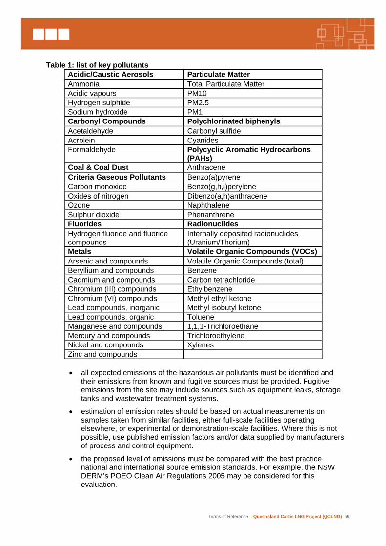
Terms of Reference – Queensland Curtis LNG Project (QCLNG) 69
Table 1: list of key pollutants
Acidic/Caustic Aerosols Particulate Matter Ammonia Total Particulate Matter Acidic vapours PM10 Hydrogen sulphide PM2.5 Sodium hydroxide PM1 Carbonyl Compounds Polychlorinated biphenyls Acetaldehyde Carbonyl sulfide Acrolein Cyanides Formaldehyde Polycyclic Aromatic Hydrocarbons
(PAHs) Coal & Coal Dust Anthracene Criteria Gaseous Pollutants Benzo(a)pyrene Carbon monoxide Benzo(g,h,i)perylene Oxides of nitrogen Dibenzo(a,h)anthracene Ozone Naphthalene Sulphur dioxide Phenanthrene Fluorides Radionuclides Hydrogen fluoride and fluoride compounds
Internally deposited radionuclides (Uranium/Thorium)
Metals Volatile Organic Compounds (VOCs) Arsenic and compounds Volatile Organic Compounds (total) Beryllium and compounds Benzene Cadmium and compounds Carbon tetrachloride Chromium (III) compounds Ethylbenzene Chromium (VI) compounds Methyl ethyl ketone Lead compounds, inorganic Methyl isobutyl ketone Lead compounds, organic Toluene Manganese and compounds 1,1,1-Trichloroethane Mercury and compounds Trichloroethylene Nickel and compounds Xylenes Zinc and compounds
• all expected emissions of the hazardous air pollutants must be identified and
their emissions from known and fugitive sources must be provided. Fugitive emissions from the site may include sources such as equipment leaks, storage tanks and wastewater treatment systems.
• estimation of emission rates should be based on actual measurements on samples taken from similar facilities, either full-scale facilities operating elsewhere, or experimental or demonstration-scale facilities. Where this is not possible, use published emission factors and/or data supplied by manufacturers of process and control equipment.
• the proposed level of emissions must be compared with the best practice national and international source emission standards. For example, the NSW DERM’s POEO Clean Air Regulations 2005 may be considered for this evaluation.
Terms of Reference – Queensland Curtis LNG Project (QCLNG) 70
• undertake an impact assessment with relevant inputs of emissions and local meteorology to an air dispersion model to provide estimates of the likely impacts on the surrounding environment. The model inputs should be as detailed as possible, reflecting any variation of emissions with time and including at least a full year of representative hourly meteorological data. The model input parameters must be based on the actual stack conditions for the licence conditions. Provide stack parameters such as stack height, diameter, temperature, exit velocity and volume flow rate83. Estimate ground level concentration (GLC) at the nearest sensitive receptor(s) based on 1-hour average for maximum (99.9 percentile) and 99.5 percentile values. Results of the dispersion modelling must be presented as concentration contour plots and frequency contour plots. The predicted average ground level concentration should be made for both normal and expected maximum emission conditions and the worst case meteorological conditions should be identified and modelled where necessary. Ground level predictions should be made at any residential, industrial and agricultural developments believed to be sensitive to the effects of predicted emissions. The techniques used to obtain the predictions should be referenced, and key assumptions and data sets explained.
• describe the background ambient air concentration from the existing sources in the airshed and evaluate the cumulative impact on the receiving environment. Address both acute and cumulative impacts by considering the project in conjunction with existing and known future emission sources within the region. Describe air shed management and the contribution of the project to air shed capacity in view of existing and future users of the air shed for assimilation and dispersion of emissions.
• the assessment of proposed levels of emissions of dust, fumes and odours should include emissions during both normal and upset conditions. Consideration should be given to the range of potential upset condition scenarios and the air emissions that may be generated as a result.
• identify ‘worst case’ emissions that may occur at start-up, shut-down or during other ‘upset’ operating conditions. If these emissions are significantly higher than those for normal operations, it will be necessary to evaluate the worst-case impact as a separate exercise to determine whether the planned buffer distance between the facility and neighbouring sensitive receptors will be adequate.
• if odour is an issue, conduct odour impact assessment using the criteria described in the Queensland DERM Guideline of “Odour Impact Assessment from Developments”. The guideline sets out various approaches to assess potential impacts from developments proposals. Guidance provides the use of air dispersion modelling as a tool to predict ground level odour concentrations and comparison must be made with guideline values to determine the likelihood of adverse odour impacts.
• the averaging period for ground level concentrations of pollutants that are modelled should be consistent with the relevant averaging periods for air quality indicators and goals in the Environmental Protection Policy (Air) 1997 and the National Environmental Protection Measure (NEPM) Air. For example, the modelling of sulphur dioxide must be conducted for 10-minutes, 1-hour, 24-hours and annual averaging periods.
83 DERM (EPA)
Terms of Reference – Queensland Curtis LNG Project (QCLNG) 71
• modelled air quality concentrations at the “most exposed existing or likely future off-site sensitive receptors” must be compared with the appropriate national and international ambient air quality standards including the Environmental Protection (Air) Policy 1998 and the National Environmental Protection Council (Ambient Air Quality) Measure.
• for the assessment of chemical species not listed in EPP (Air), the design criteria prescribed by the Victorian Government State Environment Protection Policy (Air Quality Management, 2001), based on odour or toxicity classification could be utilised.
• the human health risk associated with emissions from the facility of all hazardous or toxic pollutants should be assessed whether they are or are not covered by the National Environmental Protection Council (Ambient Air Quality) Measure or the Environmental Protection (Air) Policy 1998.
• where there is no single atmospheric dispersion model that is able to handle the different atmospheric dispersion characteristics exhibited in the proposal area (e.g. sea breezes, strong convection, terrain features, temperature inversions and pollutant re-circulation), a combination of acceptable models will need to be applied.
• the limitations and accuracy of the applied atmospheric dispersion models should be discussed. The air quality modelling results should be discussed in light of the limitations and accuracy of the applied models.
• describe air shed management and the contribution of the proposal to air shed capacity in view of existing and future users of the air shed for assimilation and dispersion of emissions.
• evaluate the extent to which nitrogen oxides and volatile organic compounds emissions from the proposal and existing emission sources within the region will contribute to the generation of photochemical smog.
• evaluate the extent to which sulphur dioxide emissions from the proposal and existing emission sources within the region will contribute to the generation of acidification of atmospheric condensation such as rain and dew.
3.5.1 Greenhouse gas emissions
Description of environmental values This section of the EIS should:
• estimate the projected annual Scope 1 emissions, where ‘Scope 1 emissions’ means direct emissions of greenhouse gases from sources within the boundary of the facility and as a result of the facility’s activities
• estimate the projected annual Scope 2 emissions, where ‘Scope 2 emissions’ means emissions of greenhouse gases from the production of electricity, heat or steam that the facility will consume, but that are physically produced by another facility
• briefly describe the method used to estimate the greenhouse gas emissions.
The emissions may be estimated using the methodology contained in the National Greenhouse Accounts (NGA) Factors, Department of Climate Change (January 2008), or the most recent version.
Terms of Reference – Queensland Curtis LNG Project (QCLNG) 72
Potential impacts and mitigation measures This section must describe the comprehensive inventory of annual greenhouse gas (GHG) emissions that will be anticipated from the project and identify the contribution of the range of GHG mitigation measures incorporated in the plant design. These include but are not limited to the addition of waste heat recovery and additional vapour recovery for ship loading, the use of high efficiency gas turbines and/or compressors and the use of low BTU fuel. Review the greenhouse offsets (if any) and presents these with options to be considered. The assessment of the proposal’s greenhouse inventory should include at least the following matters:
• provide an inventory of projected annual emissions for each relevant greenhouse gas, both on-site and off-site attributable to the project, and with total emissions expressed in ‘CO2 equivalent’ terms
• estimate emissions from upstream activities associated with the proposed project, including fossil fuel based electricity consumed
• briefly describe method(s) by which estimates were made
• present CO2 equivalents emissions as a percentage of Queensland’s and Australia’s annual greenhouse gas emissions
• the intended measures to avoid, minimise or offset greenhouse emissions, including any sink-enhancement activities
• an analysis of comparable technologies, processes and equipment to demonstrate the degree to which the selected option minimises emissions
• an identification of accountabilities
• intended audit and critical review procedures.
The section must include a comprehensive greenhouse gas reduction strategy for the plant that include (but not limited to) items such as: the company’s policy on greenhouse gas emissions, an energy efficiency program, a continuous improvement program and better control systems, and action plans for cost effective mitigation measures employed in the design of the project.
3.5.2 Greenhouse gas abatement This section of the EIS should assess greenhouse gas abatement measures. It should include):
• a description of the proposed measures (alternatives and preferred) to minimise greenhouse gas emissions directly resulting from activities of the project
• an assessment of how the preferred measures minimise emissions and improve energy efficiency
• an indication of how the project’s energy consumption and emissions compare with the relevant sector of industry
• identify opportunities to reduce energy purchased and review opportunities to use renewable energy sources
• sufficient flexibility to take account of any future changes to legislation and policy in this regard and any future relevant emissions trading scheme.
Terms of Reference – Queensland Curtis LNG Project (QCLNG) 73
Whilst recognising that the EIS process will identify environmental aspects and appropriate mitigation options, the environmental management plan in the EIS should include a specific module to address greenhouse abatement. That module should include:
• commitments to the abatement of greenhouse gas emissions from the project with details of the intended objectives, measures and performance standards to avoid, minimise and control emissions
• commitment to energy efficiency opportunity assessment and technology review, including undertaking periodic energy assessments with a view to progressively improving energy efficiency
• voluntary initiatives such as the national Greenhouse Challenge Plus program
• commitments to monitor, assess and report on greenhouse emissions from relevant activities and the success of mitigation measures in accordance with the National Greenhouse and Energy Reporting Act 2007.
3.5.3 Climate change adaptation Climate change, through alterations to weather patterns and rising sea level, has the potential to impact in the future on developments designed now. Most developments involve the transfer to, or use by, a proponent of a community resource in one form or another, such as the granting of a non-renewable resource or the approval to discharge pollutants to air, water or land. Therefore, it is important that the project design be adaptive to climate change so that community resources are not depreciated by projects that would be abandoned or require costly modification before their potential to provide a full return to the community is realised. Consequently, the EIS should provide an assessment of the project’s vulnerabilities to climate change and describe possible adaptation strategies for the activity including:
• a risk assessment of how changing patterns of rainfall and hydrology, temperature, extreme weather and sea level (where appropriate) may affect the viability and environmental management of the project.
• the preferred and alternative adaptation strategies to be implemented; and
• commitments to undertaking, where practicable, a cooperative approach with government, other industry and other sectors to address adaptation to climate change.
It is recognised that predictions of climate change and its effects have inherent uncertainties, and that a balance must be found between the costs of preparing for climate change and the uncertainty of outcomes. However, proponents should use their best efforts to incorporate adaptation to climate change in their EIS and project design.84
3.6 Noise and vibration
Description of environmental values The EIS should describe the existing environmental values that may be affected by noise and vibration from project activities. If project activities could adversely impact on the noise environment, baseline monitoring should be undertaken at a selection of noise sensitive sites affected by the proposal. Noise sensitive places in relation to the project should be
84 DERM (EPA)
Terms of Reference – Queensland Curtis LNG Project (QCLNG) 74
identified on a map at a suitable scale. The results of any baseline monitoring of noise and vibration in the proposed vicinity of the proposal should be described. The daily variation of existing noise levels at nearby sensitive sites should be monitored and reported in the EIS, with particular regard given to detailing variations at different periods of the day and night, including seasonal variations. Monitoring methods should adhere to relevant DERM guidelines and Australian Standards, and any relevant requirements of the Environmental Protection (Noise) Policy 1997 (EPP (Noise)). Comments should be provided on any current activities near the project areas that may cause a background level of noise and ground vibration (e.g. other industry, railway, major roads, etc.) Assessment should be made of the potential emission of low-frequency noise (noise with significant components below 200Hz) from major items of equipment and plant. If necessary, measures should be described for reducing the intensity of these components. Reference should be made to the DERM draft guideline, Assessment of Low Frequency Noise. Potential impacts and mitigation methods The levels of noise generated during construction (including any blasting) and operation of all components of the project should be assessed against current typical background levels. Anticipated noise levels, their timing and duration, should be considered in conjunction with the sensitivity of receptors. An estimate should be made of the cumulative noise level at the fenced boundaries of the project, particularly in the proximity of compressor stations and LNG facility, and at the boundaries of existing land uses likely to be affected by noise from the project. This estimate should include noise from construction, operation and from transport movements.
Information, including mapped noise contours from a suitable acoustic model, should be submitted based on the proposed generation of noise. The potential environmental harm of noise and vibration at all potentially sensitive places, in particular, any place of work or residence should be quantified in terms of objectives, standards and indicators to be achieved and measurable indicators. Particular consideration should be given to emissions of low-frequency noise; that is, noise with components below 200Hz. The assessment should also include environmental impacts on terrestrial and marine animals and avifauna, particularly migratory species. Proposals to minimise or eliminate these effects should be outlined, including details of any screening, lining, enclosing or bunding of facilities, or timing schedules for construction and operations that would minimise environmental harm and environmental nuisance from noise85.
Off-site transport noise and vibration factors due to road should be described and include a discussion on existing speed zones, scheduled transport movements and industry.
85 DERM (EPA)
Terms of Reference – Queensland Curtis LNG Project (QCLNG) 75
3.7 Waste
3.7.1 Waste generation
Description of environmental values This section should provide technical details of waste generation, treatment, minimisation and management. Sources of waste associated with the construction, operation and decommissioning of the project should be identified and described including:
• the type and amount of wastes produced, including an inventory of solid and liquid (including wastewater and sewage) wastes generated by each stage of the project
• volumes and chemical analysis of wastewater generated by the treatment of associated water for other beneficial uses
• collection, handling, transport and fate of wastes including storage
• market demand for recyclable waste (where appropriate)
• opportunities for waste avoidance, reuse within the project and minimisation techniques
• location, site suitability, dimensions, source and volume of any landfill, including method of construction.
3.7.2 Waste management
Description of environmental values The EIS should provide details of waste management methods, which demonstrate that waste minimisation and cleaner production techniques and designs have been implemented through the selection of processes, equipment and facilities to prevent or minimise environmental impacts. This information should include:
• descriptions of processes, equipment and facilities to be incorporated into the overall project specifically for the purpose of avoiding waste generation, separation of wastewater from solid waste, reusing or recycling wastes, or on-site treatment methods for wastes to lessen their effect on the natural environment
• proposed means for management of wastes produced under circumstances other than as a result of normal project development, including wastes generated during modification (e.g. run-off, chemical cleaning before commissioning), unusual conditions when the facilities are operating (e.g. start-up, maintenance, shut-down) and domestic sewage and refuse
• council waste facilities along the project route and their ability to handle expected waste generation86
• methods to prevent seepage and contamination of groundwater from waste stockpiles
• methods to avoid stormwater contamination by raw materials, wastes or products and present the means of containing, recycling, reusing, treating and disposing of stormwater, having regard for the requirements of the EPP (Water)
86 Dalby Regional Council
Terms of Reference – Queensland Curtis LNG Project (QCLNG) 76
• risk assessment and monitoring procedures for individual sites in relation to the above points.
Stormwater management should also address:
• nominated stormwater discharge points and discharge criteria
• design criteria, diversions, volume and capacity of any retention ponds, process tanks or bunded areas, as well as those reasonable and practicable measures proposed to prevent the likely release of contaminated stormwater to any drain or waters
• potential impacts during extreme rainfall events
• information on the collection, treatment and disposal of contaminated stormwater runoff from the plant and associated materials handling facilities
• details of expected contaminants (e.g. chemical composition, particulates, metals, effluent temperature and pH) in controlled discharges of proposed wastewater and stormwater management systems
• impacts of discharges on potential receiving waters, particularly effects on the downstream environment of stormwater releases (i.e. water – salt balance)
• where solid or liquid wastes are to be disposed of off-site outline the expected disposal strategies.
Details of discharge wastewater into Gladstone harbour must identify any potential contaminants likely to impact on approvals for disposal of material from maintenance dredging operations.
3.8 Transport
3.8.1 Transport methods and routes
Description of environmental values The EIS should provide sufficient assessment of the impacts of project traffic during construction and operations to allow the DTM and Local Governments87 to ascertain its effect on transport safety and efficiency requirements. QGC should fully assess transport-related impacts of the project including sea, rail, road and air, such as:
• road and rail safety issues, for example, ensuring safe access and transition across the construction sites and safety for other transport users
• road use resulting in reduced life of roads/pavements requiring additional or accelerated rehabilitation and maintenance
• routes of ships in transit through port waters and the aligned infrastructure such as navigational aids88
• seasonal considerations such as potential for transport impacts during wet weather
87 Dalby Regional Council 88 Maritime Safety Queensland
Terms of Reference – Queensland Curtis LNG Project (QCLNG) 77
• reduced efficiency of traffic flows along road sections and at intersections along key routes, including regional routes such as the Toowoomba range road89, especially during construction including details on maximum traffic delays
• any impacts to railways and rail open level crossings arising from any project related construction and operational traffic
• impacts on air transport in the gas field region90
• environmental issues relating to transport (e.g. weed management, vegetation clearing in road/rail reserves, dust control and erosion protection).
This section should outline:
• procedures for assessing and agreeing on the scope of required mitigation works with road/rail corridor managers, including any associated works, such as sourcing water and gravel
• strategies to minimise the effects of project transport on existing and future public road or rail corridors
• steps to be taken to prevent access from public roads/rail corridors to the project sites
• strategies to maintain safe access to public road/rail reserves to allow road/rail/pipeline maintenance activities
• process for decommissioning of any temporary access to road/rail reserves, eg, stockpile sites91.
Findings of studies and transport infrastructure impact assessments should be an input into preparing a draft road-use management plan. Conditions of approval for transport management impacts should also be detailed in the EMP (see Section 4.0). Road infrastructure impacts should be assessed according to DTM’s Guidelines for Assessment of Road Impacts of Development (April 2006). Reference should be made to other DTM planning documents and relevant legislation. This section should describe existing transport infrastructure facilities within and adjacent to the project areas. The location and owner/custodians of all tenures, reserves, roads and road reserves, railways and rail reserves, stock route easements, marine traffic and the like, covering the affected land should be shown. The locations and descriptions of relevant existing roads, railways, gas and water pipelines, power lines, telecommunications systems, constructed waterways, and any other infrastructure within the project areas, or likely to be affected by project activities, should be provided. Transport infrastructure also includes the transport operations that utilise that infrastructure. Maps should be provided at an appropriate scale and level of detail. Any environmental values likely to be affected by this infrastructure should be described, in particular, the presence, risk and potential spread of pest and diseases strategies should be presented, taking into account relevant council pest management plans.
89 Toowoomba Regional Council 90 Dalby Regional Council 91 DTM (DMR)

Terms of Reference – Queensland Curtis LNG Project (QCLNG) 78
Potential impacts and mitigation methods This section of the EIS should detail impacts of the project on existing roads, railways, port facilities. This evaluation should include any potential requirements to reschedule existing infrastructure construction, rehabilitation and maintenance programs. Impacts resulting from the transport of plant, equipment, raw materials, wastes and personnel during the construction and operational phases of the project should be described and analysed. The description and analysis should address the capacity of existing facilities to support the requirements and any additional requirements for the construction, upgrading or relocation of any transport related infrastructure required by the project directly and as a result of potential cumulative impacts. The analysis should also address any requirements for new or changed services in road reserves. Special reference should be made to any relationship between road works undertaken as part of the project and works proposed in DTM’s Roads Implementation Program where details of such works are provided by the DIP to QGC or otherwise published. Potential road impacts of the project should be described and assessed according to DTM’s Guidelines for Assessment of Road Impacts of Development (April 2006). Any proposed new infrastructure provision or requirements to mitigate impacts of development on State-controlled roads should be in accordance with DTM’s Road Planning and Design Manual. The EIS should also discuss the results of consultation with the relevant district and regional officers of DTM and local government regarding the potential impacts of the project on the road network. Where reference is made to the planning schemes of the relevant local governments, it is suggested that this also include any publicly available draft planning schemes. This section should also address how transport elements and impacts of the project, taking into account publicly published or DIP advised future demand growth, (including the potential impact of other major infrastructure and industrial projects in the nearby area) relate to DTM’s existing transport strategies for the Central Queensland area and the future infrastructure needs of this area as presented in State Government documents, including: Statements of Intent for Road Link Development; Gladstone Integrated Regional Transport Plan 2001 – 2030; and Capricornia Integrated Regional Transport Plan 2004 – 2030. It is also necessary to make reference to publicly published or DIP advised planning schemes of the relevant local governments. The EIS should specifically document and analyse various road access and road use options to facilitate the construction and operation of the project and to mitigate the impacts on the road system. Consultation should take place with the DTM and other government infrastructure agencies (for example, GPC, QR and CG) as well as the Gladstone Regional Council and other relevant local governments with respect to developing an integrated approach with this and other existing or planned projects (whether publicly published or advised by DIP) known to QGC.
Terms of Reference – Queensland Curtis LNG Project (QCLNG) 79
The Regional Harbour Master Gladstone should be consulted regarding maritime issues relating to the movement and loading of LNG tankers and any barge operations. The EIS should discuss the results of the consultation.
3.8.1.1 Shipping Describe current vessels utilising the port and in the Commonwealth Marine area92, their size, shipping movements, anchorages, access to/from the port and navigational arrangements.
Potential impacts and mitigation methods In regard to increased shipping volumes, the following should be specifically addressed:
• potential for introduction of exotic organisms from increased shipping rates
• ballast water management arrangements - including Australian Quarantine and Inspection Service (AQIS) mandatory arrangements and agency contingency planning
• management of ship waste, in particular quarantine waste, domestic garbage, oil and sewage
• potential risk of spills and their management93
• potential foreshore damaged caused by LNG tanker and tug activities
• potential for increased vessel strike to marine species94
• potential impacts on existing shipping activity.
Additional marine transport issues that should be considered include the potential of the proposal to impact on recreational craft.
3.8.1.2 Road and rail Describe the current road and rail networks and intersections of the surrounding region and specify current traffic volumes. The current rail operations occurring during the project construction phase should also be described. This description should identify whether they comprise 24 hours a day/ seven day a week, and the number and types of services per day (e.g. coal, general freight, passenger services).
Potential impacts and mitigation methods The EIS should provide sufficient information and analysis to make an independent assessment of how the state-controlled and local government road and rail networks will be affected throughout the duration of the project. The potential impact on stakeholders and management of those impacts should be detailed. A range of alternatives should be assessed with respect to road infrastructure to serve the construction and operation. Details should be provided on the potential impacts of alterations to the existing road network and possible interruptions to traffic as a result of these alterations. Details should be provided on the impacts on environmental values of any new roads or road realignments.
92 DEWHA 93 DEWHA 94 DEWHA
Terms of Reference – Queensland Curtis LNG Project (QCLNG) 80
Information about road impacts and proposed measures for dealing with those impacts should be prepared by the proponent in close consultation with the relevant local Regional and district offices of the DTM and other relevant councils. QGC is to consider DTM’s published plans for future upgrades for the road network which may impact the study area. QGC should also provide information on product spill contingency plans and the adequacy of equipment and facilities to deal with possible spills for the transport nodes of the proposal. The EIS should outline details of any potential impacts on existing or proposed pedestrian and cycle networks as advised by DIP or otherwise publicised.
3.8.2 Road infrastructure alterations
Description of environmental values The EIS should detail proposed alterations to road infrastructure occasioned by the project. This includes road realignments, grade separated crossings, level crossings, road upgrades and resurfacing, bridges, access roads, and associated civil works. A traffic analysis should be presented to indicate the impacts or improvements to traffic flows and capacity both during construction and after completion. Particular attention should be paid to:
• requirements for access to road/rail corridors during construction, including emergency access
• methods to be adopted to ensure safety and avoid obstruction to other road/rail users during construction
• proposed traffic management arrangements and plans
• capacity and safety improvements as a result of road infrastructure alterations.
3.9 Cultural heritage This section should address issues raised by the Aboriginal Cultural Heritage Act 2003 (ACH Act) and the Queensland Heritage Act 1992 (QHA). To appropriately manage both cultural heritage areas, separate cultural heritage studies will be required to describe indigenous and non-indigenous cultural heritage. This will result in separate cultural heritage management strategies being prepared to provide a management tool for future construction, operation and closure of the project or an element of it.
3.9.1 Indigenous Cultural heritage
Description of environmental values This section should describe the existing Aboriginal cultural heritage values that may be affected by the project and the environmental values of the cultural landscapes of the affected area in terms of the physical and cultural integrity of the landforms.
3.9.2 Non-indigenous cultural heritage This section should describe the existing non-indigenous cultural heritage values that may be affected by the project. A strategy should be prepared to identify heritage assets, provide a management tool for identified heritage sites, recommend protection strategies, provide for a method of reporting discoveries made and ensure that obligations under the Queensland Heritage Act 1992 are met. Any cultural heritage study must be conducted by a suitably qualified expert and will require:
Terms of Reference – Queensland Curtis LNG Project (QCLNG) 81
• the chief executive of the DERM is to be notified if an historical archaeological artefact, that is an important source of information about an aspect of Queensland history, is found during the course of the study
• a systematic survey of the proposed development area to locate and record non-indigenous cultural heritage places
• significance assessment of any cultural heritage sites/places located
• the impact of the proposed development on cultural heritage values
• a report of work done which includes background research, relevant environmental data and methodology, as well as results of field surveys, significance assessment and recommendations.
The study should include findings of consultation with:
• DEHWA concerning the Register of the National Estate, Commonwealth Heritage list and National Heritage list
• DERM regarding the Queensland Heritage Register and other information regarding places of potential non-indigenous cultural heritage significance
• the DERM regarding the Indigenous Site Database
• any local government heritage register
• any existing literature available from Queensland Government sources or provided to QGC by local community groups/organisations relating to the affected areas
• liaison with relevant community groups/organisations (e.g. local historical societies) concerning:
− places of non-indigenous cultural heritage significance
− opinion regarding significance of any cultural heritage places located or identified.
Investigations and consultation should be undertaken in such manner and detail as to satisfy statutory responsibilities and duties of care, including those under the Queensland Heritage Act 1992 and the ACH Act, and the Australian Aboriginal and Torres Strait Islander Heritage Protection Act 1984.
Potential impacts and mitigation methods This section defines and describes the objectives and practical measures for protecting or enhancing cultural heritage environmental values, describes how nominated quantitative standards and indicators may be achieved for cultural heritage management, and how the achievement of the objectives will be monitored, assessed and managed. To the greatest extent practicable, significant heritage areas should be avoided by the project. The EIS should provide an assessment of likely effects on sites of non-indigenous or indigenous cultural heritage value, including but not limited to the following:
• description of the significance of artefacts, items or places of conservation or cultural heritage values likely to be affected by the project and their values at a local, regional and national level
• recommended means of mitigating any negative impact on cultural heritage values and enhancing any positive impacts.
Terms of Reference – Queensland Curtis LNG Project (QCLNG) 82
In the absence of a native title agreement the preparation of a Cultural Heritage Management Plan (CHMP) should be initiated during the EIS process. Completion of the approved CHMP will ensure that the project meets the Aboriginal cultural heritage duty of care imposed by the ACH Act.
If a CHMP has not been approved by the time of submission of the EIS to the CG then the following should be provided:
• an outline of the draft CHMP, subject to any confidential provisions, outlining the position of the endorsed cultural heritage parties
• details of the proposed steps and timeframes for seeking ratification of the CHMP
• Preparation of the CHMP must comply with the requirements of the ACH Act.
Impacts on Aboriginal cultural heritage sites, objects or values in the vicinity of the project should be managed under approved CHMPs developed specifically for the project. The CHMPs will provide a process for the management of Aboriginal cultural heritage places (including subsurface) at the project sites. It is usual practice for the CHMPs to be based on information contained in archaeological and/or anthropological reports on the survey area and cultural heritage survey reports and/or information from the relevant Aboriginal parties. The CHMPs should address and include the following:
• a process for including Aboriginal people associated with the development areas in protection and management of Aboriginal cultural heritage
• processes for mitigation, management and protection of identified cultural heritage sites and objects in the project areas, including associated infrastructure developments, both during the construction and operational phases of the project
• provisions for the management of the accidental discovery of cultural material, including burials
• a clear recording process to assist initial management and recording of accidental discoveries
• the development of a cultural heritage awareness program to be incorporated into contractor/employee manual as well as induction manual. This is to be in the form of a plain language, short document which is easy for contactors and staff ‘on the ground’ to understand
• a conflict resolution process.
The development of the CHMPs should be negotiated between the proponent and the relevant Aboriginal parties.
3.10 Cumulative impacts
The purpose of this section is to provide a clear and concise summary of the cumulative impacts detailed in prior sections, and to provide a description of these cumulative impacts both in isolation and in combination with other known, existing or proposed project(s) (where details of such proposed projects have been provided to QGC by the DIP or are otherwise published), to the greatest extent practicable. The methodology which has been used to determine the cumulative impacts of the project should also be presented, detailing the range of variables considered, including where applicable, relevant baseline or other criteria upon which the incremental aspects of the project have been assessed.
Terms of Reference – Queensland Curtis LNG Project (QCLNG) 83
4. Social values and management of impacts Description of social values This section describes the existing social values that may be affected by the project. The social amenity and use of the project areas and adjacent areas for rural, agriculture, forestry, fishing, recreation, industrial, educational or residential purposes should be described. Consideration should be given to:
• community infrastructure and services, access and mobility;
• population and demographics of the affected community;
• local community values, vitality and lifestyles;
• recreational, cultural, leisure and sporting facilities and activities in relation to the affected area;
• recreational and commercial fishers;
• health, emergency services and educational facilities;
• on farm activities near the proposed activities;
• number of properties directly affected by the project; and
• number of landowner families directly affected by the project, but also families of workers either living on the property or workers where the property is their primary employment.
Describe the social values for the affected area in terms of:
• the integrity of social conditions, including amenity and liveability, harmony and well being, sense of community, access to recreation, and access to social and community services and infrastructure; and
• public health and safety.
Information should also be provided on the existing housing market, and include a description of such issues as size of private rental market, vacancy rates, average rents, availability and cost of residential housing in the area and the availability of land for residential development purposes. This section should also detail the existing social and economic environment. Issues to be addressed include:
• key characteristics of potentially affected communities in the project area, with community profiles, including:
− mapping of rural properties, croplands and grazing areas;
− population and demographics of the affected community (including size, age structure, gender composition, residency;
− workforce characteristics, including types of skills or occupations and availability both for construction and operation phases of the Project;
− identification of existing labour force and unemployment statistics;
− health, emergency services and educational facilities; and
− other community services and facilities (e.g. recreational, cultural, leisure and sporting facilities);
Terms of Reference – Queensland Curtis LNG Project (QCLNG) 84
• accommodation, with an emphasis on:
− the size of the private rental market in the area;
− the vacancy rate and price of rental accommodation, including assessment of seasonal fluctuations;
− the availability and typical cost of housing for purchase in the area; and
− the level of, and demand for, social housing in the area;
• housing and other land uses:
− constraints and opportunities for new housing construction or other land uses in the vicinity of the project area, including the potential for growth of the urban area to encroach on the project site; and
− land areas for residential purposes including available serviced residential lots, land under development and undeveloped broad acre land that is appropriately zoned;
• the character and basis of the local and regional economies;
• a description of large scale industrial developments and their effects in the region.
Community health and safety This section of the EIS should define and describe the objectives for protecting or enhancing community health and safety values. It should detail any impacts of the project during construction and operation on the health and safety of the community, workforce, suppliers and other stakeholders, in terms of health, safety and quality of life from factors such as: air emissions, odour, dust, pests, traffic noise and vibration, waste and water. This includes health and safety matters associated with onsite and offsite workforce accommodation. It should include details of:
• compliance with relevant Health and Safety legislation
• security arrangements
• emergency plans and safety management strategies, as well as corroboration of the effectiveness of such systems
• details of on-site emergency response capabilities (e.g. on-site paramedic or first-aid officer), for both the construction and operational phases of the project, which should include personnel trained for fire suppression and containment, rescue and first aid
• the risk assessment conclusions reached and the level of off-site risk from the proposed developments, and
• the location and nature of sensitive sites including, but not limited to, residences and schools.
• An assessment should be made of any areas where mosquitoes may breed (e.g. areas with poor drainage or where water ponds) and mitigation measures developed to prevent the harbourage and breeding of mosquitoes and other pests of public health significance.
• The EIS should include a discussion on the site planning, management, mitigation and monitoring of potential pest impacts by considering Division 2 of Part 8 of the Health Regulation 1996. This section should draw on the
Terms of Reference – Queensland Curtis LNG Project (QCLNG) 85
information in Queensland Health’s Guidelines to Minimise Mosquito and Biting Midge Problems in New Development Areas (March 2002).
Potential impacts and mitigation methods This section defines and describes the objectives and practical measures for protecting or enhancing social values, describes how nominated quantitative standards and indicators may be achieved for social impacts management, and how the achievement of the objectives will be measured, monitored and managed. The social impact assessment of the project should consider the information gathered in the community consultation program and the analysis of the existing socio-economic environment, and describe the project’s impact, both beneficial and adverse, on the local community. The impacts of the project on local and regional residents, community services and recreational activities are to be analysed and discussed for all stages of the development. The nature and extent of the community consultation program are to be described and a summary of the results incorporated in the EIS. The social impact assessment should include sufficient data to enable state authorities, such as Queensland Health and Education Queensland, to plan for the continuing provision of public services in the region of the project. QGC should consult the relevant management units of the state authorities, and summarise the results of the consultations in the EIS. These impacts should be considered both at a regional and local level. Attention should be paid to:
• impacts on demographic, social, cultural and economic profiles;
• impacts on local residents, current land uses and existing lifestyles and enterprises;
• impacts on local and state labour markets, with regard to the source of the workforce:
− this information is to be presented according to occupational groupings of the workforce;
− the impacts of both construction and operational workforces and associated contractors on housing demand/ availability, community services and community cohesion is to be addressed;
− the capability of the existing housing stock, including rental accommodation, to meet any additional demands created by the project is to be discussed. This should include, to the greatest extent practicable, description of the cumulative impacts on environmental values caused by the proposed project, in isolation or in combination with other known or proposed projects (where details of such proposed projects are provided by DIP to QGC or otherwise published).
• comment should be made on how much service revenue and work from the project (e.g. provisioning, catering and site maintenance) would be likely to flow to existing communities in the area of the project, particularly if a fly-in, fly-out workforce is proposed;
• impacts on local residents’ values and aspirations; and
• in regard to affected indigenous and non-indigenous communities respectively, particular attention should be paid to the effects on:
Terms of Reference – Queensland Curtis LNG Project (QCLNG) 86
− the ability of both indigenous and non-indigenous people, to live in accordance with their own values and priorities;
− the use of and access to culturally important areas and landscapes;
− the access to existing human and commercial services and housing;
− the ability to participate in regional and local employment and training opportunities; and
− the new project workforce and their families.
The social and community impacts of the project should be addressed, incorporating any stakeholder concerns about adverse impacts to the natural, social, economic or built environment. Relevant strategies and resources that will be committed to address expected impacts should be outlined. The potential impact on the amenity of adjacent areas used for commercial and recreational fishing, boating/yachting (as a result of jetty exclusion zones), cropping, grazing, forestry, recreation, industry, education, aesthetics, scientific or residential purposes should be discussed. Also, the implications of the proposal on potential future developments in the local area, including constraints on surrounding land. Cumulative social impacts The cumulative social impacts on the community, brought about by this project together with other concurrent existing projects or proposed projects (where details of such proposed projects have been provided to QGC by the DIP or are otherwise published) must also be carried out in consultation with the Department of Communities and via a cumulative Social Impact Assessment (SIA). Reference to CQSS2 3.9 Social- target and indicators for viable town and communities should also be considered when undertaking the assessments. Particular attention should be paid to:
• the increase in population in the region brought about by the construction and operational workforces and the resulting implications for the provision of government and other services
• the availability of accommodation for the project’s workforce and the possible cumulative impact on the housing and rental market
• the proposed long-term and post use of any workers’ village constructed for the project
• the development of a demographic profile of the region and the associated sufficiency of current infrastructure and services
• the development of a community consultation management plan that promotes
• an active role for impacted communities.
5. Impacts on state and local economies and management of those impacts. The general economic benefits/ impacts from the project should be described, including:
Terms of Reference – Queensland Curtis LNG Project (QCLNG) 87
• the relative significance of this proposal in the local and regional economic context
• the extent to which local and other Australian goods and services will be used
• the short and long-term beneficial (e.g. job creation) and adverse (e.g. competition with local small business) impacts that are likely to result from the development
• the potential needs for skills training in the new LNG industry, including maritime handling skills95
• the need for any additional infrastructure provision by government to support the Project
• implications for future development in the locality (including constraints on surrounding land uses and existing industry)
• the potential impact of the project on the domestic gas market and domestic gas prices, including the ability of the power generation sector to meet government emission targets and gas-power level targets.
The economic impacts of the project could be discussed in the context of the CQSS2 3.8 – Economy – Aspirational targets and on-ground actions to explain the predicted cumulative and intergenerational impacts and proposed monitoring and mitigation measures. Any new skills and training to be introduced in relation to the project should be identified. Adequate provision should be made for apprenticeship and worker training schemes. The EIS should indicate the occupational skill groups required and potential skill shortages anticipated.
6. Hazard and risk
Hazard and risk assessment The EIS should identify all legislation, standards and codes of practice in relation to the transport storage and handling of hazardous materials and in particular dangerous cargos in port areas. A risk assessment consistent with Australian / New Zealand Standard for Risk Management AS2885, AS4360:2004 and/or a comparable international standard shall be conducted. The study must assess risks during the construction, operational and decommissioning phases of the LNG facility. These risks are to be assessed in quantitative terms where possible.
• A preliminary hazard identification exercise should be conducted in order to identify the nature and scale of hazards which might occur during the construction and operation of the project. This would be expected to include hazards involving:
• construction accidents
95 Maritime Safety Queensland
Terms of Reference – Queensland Curtis LNG Project (QCLNG) 88
• pipeline, processing unit or storage vessel rupture or loss of containment, and explosions and fires associated with such incidents (resulting in supply reliability issues)
• release of liquid gaseous or particulate pollutants or any other hazardous material used, produced or stored on the site
• marine collision
• spills of materials during ship loading
• the potential for breaching of LNG vessel’s hulls and the resulting breach size and spill rate
• the extent of thermal dispersion and resulting hazard/ignition zones following accidental or deliberate spillage (e.g. 35 kWm2 and 5kWm2 analysis); and natural events such as cyclones, earthquakes, bushfires or local flooding.
In particular, detailed risk assessments associated with marine operational activities, while LNG vessels are at berth, during loading and during vessel movements within the port limits, are undertaken to identify all risks and mitigation measures required to ensure that operational activities associated with LNG vessels do not impact on other operational activities within the port. This assessment should consider growth in shipping in Gladstone port considering the various projects proposed for the port.96
A set of representative incident scenarios should be selected. This set should include credible event scenarios (e.g. a catastrophic failure of a processing unit and the consequential explosion zone). This will require an evaluation of the likelihood of each scenario occurring in order to calculate the level of risk in surrounding areas due to the presence of the facility. The risk analysis should include fatality and serious injury consequences, and present individual fatality risk contours at 0.5, 1, 5, 10, and 50 x 10-6 per year and injury risk contours at 10 and 50 x 10-6 per year. Risk contours should be presented on a suitably scaled location map. In addition, detailed risk assessment of the plant and associated operational activities should be undertaken to identify risks and mitigation measures to ensure containment within the site boundaries, so as not to impact on future industrial development on adjacent industrial land. Any identified impact on the project should also be extended to determine the resultant impact on the surrounding areas and community. Cumulative Risk The risk analysis is to address the potential impacts that may occur on the normal on-site day-to-day activities during the construction and/or operation of the facilities. Furthermore, QGC must determine the level of change that may result on the risk contours of other relevant existing or proposed industrial facilities (where details of such proposed facilities are provided by the DIP to QGC or otherwise published) in the area as a result of the proposed project. Individual risk criteria should be used to limit risks to individual workers and members of the public. Societal risk criteria should be used to limit risk to the affected population as a whole.
96 Maritime Safety Queensland
Terms of Reference – Queensland Curtis LNG Project (QCLNG) 89
Any changes to operating or storage procedures that would reduce the possibility of these events occurring, or reduce the severity of the events should they occur, are to be identified and adopted where appropriate. Draft risk management plans are to be presented for construction and operational phases of the project. The acceptability of the risk on-site and to surrounding land uses should be assessed by referring to nationally-adopted risk criteria presented in the New South Wales Department of Urban Affairs and Planning’s Hazardous Industry Planning Advisory Paper No. 4 "Risk Criteria for Land Use Safety Planning". Details of the methodology and results of each step described above should be presented in the EIS.
Emergency management plan Preliminary information on the design and operation of proposed safety/contingency systems to address terrorist attack, marine collision minimisation, fire prevention/protection, leak detection/ minimisation, release of contaminants, and emergency shutdown systems and procedures should be presented for the whole project. In addition, an assessment of businesses that may be affected in the event of an emergency should be undertaken, including strategies to mitigate the impact on these businesses. A description of the emergency planning procedure to be adopted, and a copy of the emergency plans and procedures developed to date should be included. The development of emergency planning and response procedures is to be determined in consultation with regional emergency service providers. An outline of the proposed emergency management procedures is to be provided (including evacuation plans) for the range of situations identified in the above risk assessment as providing measurable risks, including strategies to deal with contingencies such as hydrocarbon/ oil spills and natural disasters during operations. In regard to fires, the EIS should address:
• fire management systems to ensure the retention on site of fire water or other fire suppressants used to combat emergency incidents
• building fire safety measures for any construction or permanent accommodation
• details of any emergency response plans and bushfire mitigation plans under the SPP 1/03
• on-site fire fighting equipment provided and the level of training of staff who will be tasked with emergency management activities
• detailed maps showing the plant outline, potential hazardous material stores, incident control points, fire fighting equipment, etc
• an outline of any dangerous goods stores associated with the plant operations, including fuel storage and emergency response plans.
The EIS should present outlines of emergency planning and response strategies to deal with relevant incidents above, which have been determined in consultation with State and regional emergency service providers. The EIS should present plans for involvement of the relevant State agencies (such as the Queensland Ambulance Service, Queensland Fire and rescue Service and Emergency
Terms of Reference – Queensland Curtis LNG Project (QCLNG) 90
Management Queensland) in relation to emergency medical response and transport and first aid matters.
7. Environmental management plans This section of the EIS should present environmental management plans (EMPs) developed for the project. It is expected that all EMPs will, where relevant, be prepared in accordance with the DERM Guideline Preparing Environmental Management Plans. The EMPs should be developed from the preceding information in the EIS. An EMP should provide life-of-proposal control strategies in accordance with agreed performance criteria for specified acceptable levels of environmental harm. In addition, EMPs should identify:
• potential impacts on environmental values
• mitigation strategies
• relevant monitoring
• appropriate indicators and performance criteria
• provisions for review and continuous improvement97
• reporting requirements
• appropriate corrective actions, should an undesirable impact or unforeseen level of impact occur.
The aims of an EMP are to provide:
• commitments by QGC to practical and achievable strategies and design standards (performance specifications) for the management of the project to ensure that environmental requirements are specified and complied with
• an integrated plan for comprehensive monitoring and control of impacts
• local, State and Australian Government authorities, stakeholders and QGC with a common focus for approvals conditions and compliance with policies and conditions
• the community with evidence that the environmental management of the project is acceptable. The recommended structure of each element of the EMP is:
97 DEWHA
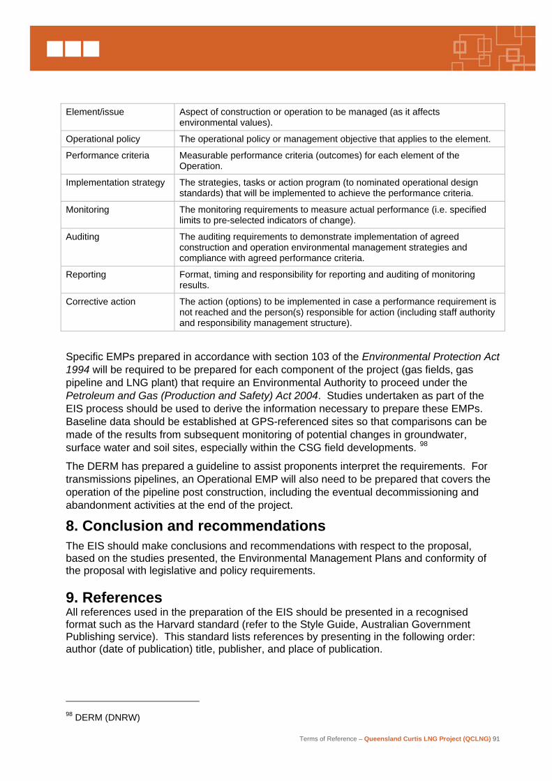
Terms of Reference – Queensland Curtis LNG Project (QCLNG) 91
Element/issue Aspect of construction or operation to be managed (as it affects
environmental values).
Operational policy The operational policy or management objective that applies to the element.
Performance criteria Measurable performance criteria (outcomes) for each element of the Operation.
Implementation strategy The strategies, tasks or action program (to nominated operational design standards) that will be implemented to achieve the performance criteria.
Monitoring The monitoring requirements to measure actual performance (i.e. specified limits to pre-selected indicators of change).
Auditing The auditing requirements to demonstrate implementation of agreed construction and operation environmental management strategies and compliance with agreed performance criteria.
Reporting Format, timing and responsibility for reporting and auditing of monitoring results.
Corrective action The action (options) to be implemented in case a performance requirement is not reached and the person(s) responsible for action (including staff authority and responsibility management structure).
Specific EMPs prepared in accordance with section 103 of the Environmental Protection Act 1994 will be required to be prepared for each component of the project (gas fields, gas pipeline and LNG plant) that require an Environmental Authority to proceed under the Petroleum and Gas (Production and Safety) Act 2004. Studies undertaken as part of the EIS process should be used to derive the information necessary to prepare these EMPs. Baseline data should be established at GPS-referenced sites so that comparisons can be made of the results from subsequent monitoring of potential changes in groundwater, surface water and soil sites, especially within the CSG field developments. 98
The DERM has prepared a guideline to assist proponents interpret the requirements. For transmissions pipelines, an Operational EMP will also need to be prepared that covers the operation of the pipeline post construction, including the eventual decommissioning and abandonment activities at the end of the project.
8. Conclusion and recommendations The EIS should make conclusions and recommendations with respect to the proposal, based on the studies presented, the Environmental Management Plans and conformity of the proposal with legislative and policy requirements. 9. References All references used in the preparation of the EIS should be presented in a recognised format such as the Harvard standard (refer to the Style Guide, Australian Government Publishing service). This standard lists references by presenting in the following order: author (date of publication) title, publisher, and place of publication.
98 DERM (DNRW)

Terms of Reference – Queensland Curtis LNG Project (QCLNG) 92
10. Recommended appendices
10.1 Final terms of reference for this EIS The finalised terms of reference should be included as an Appendix to the EIS.
10.2 Cross- reference with terms of reference This section provides a cross reference of the findings of the relevant sections of the EIS, where the potential impacts and mitigation measures associated with the project are described, with the corresponding sections of the terms of reference. A list of all commitments made by the proponent in the EIS should be provided, together with a reference to the relevant section in the EIS.
10.3 Development approvals A list should be provided of the development approvals, permits such as those for heavy loads99, marine parks approvals and environmental authorities for petroleum and gas activities required for the Project to proceed.
10.4 Study team The qualifications and experience of the study team and specialist sub-consultants should be provided.
10.5 Consultation report A list of advisory agencies should be provided in a summary consultation report, which should also list the Australian, State and Local Government agencies consulted, and the individuals and groups of community stakeholders consulted. A summary of the issues raised by these groups, and the means by which the issues have been addressed, should be provided in the text of the EIS. The discussion should include the methodology used in the community consultation program, including criteria for identifying stakeholders and the communication methods used. Information about identifying interested and/or affected persons (as defined by the EP Act 1994) should be included.
10.6 Technical data and baseline studies Relevant supporting data and information generated from specialist studies undertaken as part of the EIS are to be included as appendices. These studies may include:
• geology • soil survey and land suitability, use and capability • waterway hydrology and groundwater • flora and fauna • air quality, noise and vibration • transport and traffic • housing and accommodation • social, and socio-economic impacts • hazard and risk.
99 DMR
Terms of Reference – Queensland Curtis LNG Project (QCLNG) 93
10.7 List of proponent commitments A list of all commitments made by the proponent in the EIS should be provided, together with a reference to the relevant section in the EIS.
10.8 EPBC Act report This section should be provided as a stand alone chapter that fully addresses the issues relevant to the controlling provisions, with sub-section for each of the EPBC referrals. The report should be constructed along the lines of the following:
• title of EPBC referral and number
• description of the Project
• explanation of the infrastructure the referral relates too
• description of proposed action (as it would impact on MNES)
• description of the affected environment relevant to the controlling provisions (i.e. describe the features of the environment that are MNES protected under the EPBC Act)
• assessment of impacts on MNES and mitigation measures
• environmental record of the person proposing to take the action100
• conclusions
• references.
QGC should also, in relation to action which have national heritage places as a controlling provision, address the potential impacts (and proposed mitigation) of the project against each value for which the GBRWHA area was listed as world heritage and as a national heritage listed place.
100 DEWHA