Embed Size (px)
Citation preview
Journal of Tropical Forest Science 17 (3): 355-365 (2005) ctfTJ5D
RAINFALL INTERCEPTION AND PARTITIONING INAFROMONTA}..{E RAIN FORESTS OF THE EASTERN ARCMOUNTAINS, TANZANIA: IMPLICATIONS FOR WATERCONSERVATION
P. I{. T. Munishi
Departmmt of Fwest Biolog, Faatlty of Foratry and Nature Conservation, Sokoine University ofAgrianlture, Box 3010 Mmogmq Tanzania
&
T. H. Shear
DEartuntnt of Foratry, College of Natural Resourus, North Carokna State Uniaersity, Ralcigh NC27595, USA
Rzceiaed May 2003
MUNISHI, P. I( T. & SHEA& T. H. 2005. Rainfall interception and partitioning inafromontane rain forests of the Eastern Arc Mountains, Tanzania: implications forwater conservation. The aboveground components of the hydrologic cycle of rain forestare important processes that determine the hydrologic behaviour and dynamics ofthese ecosystems. Precipitation, throughfall, stem flow, canopy interception andstreamflowwere measured and modelled in two afromontane rain forests of the EasternArc Mountains of Tanzania. Measurements were made daily for 50 months in theUlugurus and 56 months in the Usambaras. Throughfall was 76% of the gross rainfallin the Usambaras and 79Vo in the Ulugurus. Stemflow was less than 2Vo of rainfall.Both parameters were correlated with gross rainfall (r2 = 0.97, 0.99, 0.86 and 0.94).Canopyinterception was 22Vo of ratnfallfor the Usambarasand2D7o for the Ulugurus.Streamflowwas best modelled using five months running mean rainfall in the Ulugurus(r = 0.67) and three to four months in the Usambaras (r = 0.72). A high proportion ofthe gross rainfall is delivered as net precipitation. There is effective partitioning ofrainfall on the forest canopy providing reasonable dumping effect of rainstorms. Theslow response in streamflow to rainfall events shows the efficiency of the forests tomitigate storm water impacts and thus ensuring continuous water supply. Further studiesin effects offorest harvesting on water yield are pertinent to enable adequate planningof forest utilization.
Key words: Throughfall - stemflow - interception - streamflow - afromontane - rainforest - eastern arc mountains
MUNISHI, P. I{. T. & SHEA& T. H. 2005. Pemintasan hujan dan pemetakan di hutanhujan hujan gunung Afrika di Pergunungan Ark Timur' Tanzania: implikasi bagipemuliharaan air. Komponen atas tanah kitar hidrologi hutan hujan merupakan prosespenting yang menentukan sifat serta dinamik hidrologi ekosistem ini. Curahan, jatuhtelus, aliran batang, pemintasan kanopi dan aliran sungai di dua hutan hujan gunung
*E-mail: pmunishi2)} 1 @y ahoo. com

356 Journal of Tropical Forest Scimce 17 (3) : 355-365 ( 2005 )
Afrika yang terletak di Pergunungan Ark Timur, Tanzania disukat dan dibuat model.Bacaan diambil setiap hari selama 50 bulan di Uluguru dan 56 bulan di Usambara. DiUsambara,jatuh telus adalah 76Vo daipadajumlah hujan kasar sementara di Uluguru,jumlahnya ialahT9Vo. Niran batang adalah kurang daripada2Vo jumlah hujan. Kedua-dua parameter ini berkorelasikan denganjumlah hujan kasar (l = 0.97,0.99,0.86 dan0.94). Pemintasan kanopi ialah 22Vo daripada jumlah hujan di Usambara dan diUluguru, jumlahnya ialah 20Vo. Di Uluguru aliran sungai paling baik dimodelmenggunakan purata hujan untuk lima bulan berturut-turut, tetapi memadai bagitiga hingga empat bulan di Usambara (r = 0.72) . Sebahagian besarjumlah hujan kasarturun sebagai curahan bersih. Terdapat pemetakan hujan yang berkesan di atas kanopihutan dan ini memberi kesan campakan yang agak baik terhadap hujan ribut. Tindakbalas aliran sungai yang perlahan terhadap hujan menunjukkan keberkesanan hutanmengurangkan impak air hujan ribut lantas memastikan bekalan air yang berterusan.K{ian lanjut tentang kesan penebangan hutan terhadap penghasilan air adalah pentinguntuk membolehkan r:rncang:rn bagi penggunaan hutan dibuat dengan baik.
Introduction
In Tanzania there is a general view that forest vegetation on mountains (montaneforests) secure continuous supply of water. In other words presence of montaneforests means constant supply of water during the dry season. This is contrzrry tomany studies of the influence of forests on water yield (e.g. Bosch 1982, Bosch &Hewlett 1982, Shiklomanov & Krestovsky 1988). These studies showed an increasein water yield when forest was removed. Mountains are of vital importance to theglobe as a source of water, typically having higher rates of precipitation thansurrounding lowlands. Montane forests play an important role in the water cycleincluding the capture of atmospheric moisture, storage of water in and beneathcanopies, and release to streams (Price & Butt 2000). In semiarid and arid reg"ions,more tha.n 90% of river flow comes from forested mountains (Price & Butt 2000).
To argue for forest conservation for water protection, one should be able todemonstrate the positive effects of a forest on streamflow as opposed to otherIanduses or non-forested lands. One approach is a paired watershed experimentin which runoff and rainfall are monitored in selected catchments for specificperiods around a planned alteration in landuse. Alternatively, long-term monitoringof a deforested watershed and the effects of forest regrowth on water flow can alsobe used. Estimates of runoff coefficients of forested and non-forested land can beused to assess the effects of forests on surface runoff generation. High runoffcoefficients mean larger amounts of surface runoff and lower base flows.
The hydrology of a forest ecosystem is complex, and several processes determinethe paths ofwater movementbefore itreaches the streams. These processes includeprecipitation, interception, throughfall, stemflow, evaporation and runoff. In mostof the tropics, rainfall is the major water input into a catchment. Fog condensationand horizontal precipitation may contribute considerable amount of water inputin mountain forest ecosystems and coastal environments.
The amount of interception depends on the ability of the forest to collect andretain rainfall (interception capacity), storm size and intensity, evaporation rate,vegetation type and density, and canopyheight, form and age (e.g. Shiklomanov&Krestovsky 1988). Although interception is not a major factor in most hydrologic

Journal of Tropical Forest Science L7 (3): 355-365 (2005) 357
calculations, it is believed to affect the water balance of montane forest ecosystems.On the other hand, throughfall and stemflow form the net precipitation that has apotential to enter the soil, recharge the ground water and generate stream flow(Owens 2002).
The Eastern Arc Mountains harbour hydrologically important vegetation inTanzania. Most of these forests are gazetted forest reserves in mountainous areasthat are managed for their role as major sources of water. We are developing anevaluation of the hydrologic values of the Eastern Arc mountain forests. This workwill ultimately include intensive long-term assessments of streamflow and effectsof forest management, reforestation and partial harvesting in these areas. Themajor objectives of this study were to evaluate the aboveground processes of thehydrologic cycle of these catchments, namely, precipitation, throughfall, stemflow,canopyinterception and streamflow, and to analyse their relationships in two forests.
Materials and methods
Study sites
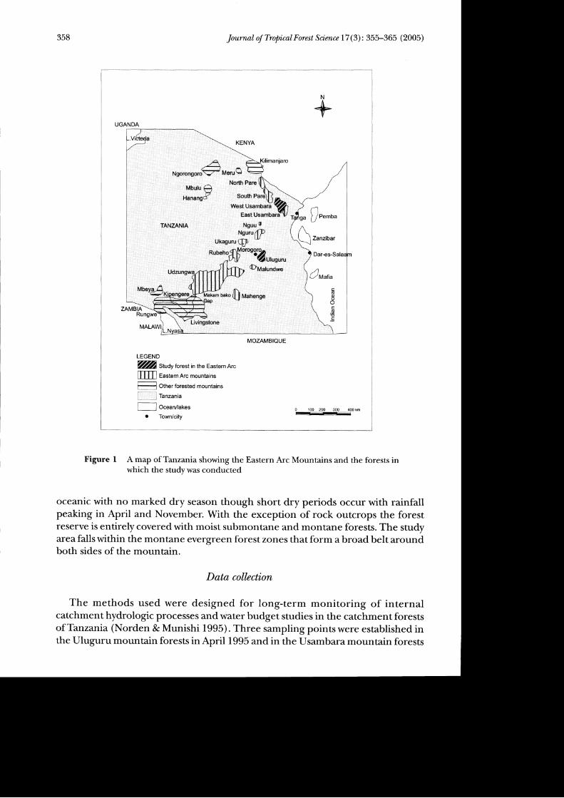
The Eastern Arc Mountains from southern Tanzania to southern Kenya run as arange of crystalline mountains near the Indian Ocean coast of Tanzaniaand Kenya(8" 51' S, 34o 49' E to 3o 2' S, 38o 20'E). The ancient crystalline rocks are part of thePre-Cambrian Mozambique belt composed of highly metamorphosed sedimentsand minor intrusive igneous bodies that originated from block faulting datingback to the Karoo period approximately 300 million years ago (Lovett 1996).
The western Usambara Mountains (Figure 1) are in the northern part of therange (4" 25'-5" 07'S, 38o 10'-38o 35'E). The climate of the Usambaras is oceanicwith bimodal rainfall partly determined by their proximity to the Indian Oceanand the equator. Rainfall peaks in April and November. The mean annual rainfallmaximum is 2000 mm in the wettest areas falling to less than 600 mm in the rainshadow areas. The study site, Mazumbai forest reserve, is on the wetter side of thisrange. The monthly rainfall averages > 50 mm and the mean annual rainfall is
1300 mm. The Usambara Mountains are composed of late Pre-Cambrian rocks ofthe Usagara system, metamorphic rocks of the gneiss type. The area contains twohighland soil types, namely, the Humic Ferrisols in the drier areas and HumicFerralitic soils in the more humid and wet areas. Moist forests occur from 150 to2285 m elevation, on the wetter eastern, southern and northern sides of themountains.
The Uluguru north forest reserve (Figure l) covers a steep summit ridge andthe northern half of the Uluguru Mountains between Morogoro town and theMgeta-Bunduki depression, within an altitude range of 1000 to 2340 m. The soilsare acidic lithosols and ferralitic red, yellow and brown latosols that have developedover Pre{ambrian granulite, gneiss and migmatite rocks. In the study area, a north-west to north-east facing slope (on the Bondwa summit at2200 m), hornblende-pyroxene granulites are dominant with injections of granite and gneiss as well as
some basic intrusions. Mean annual rainfall ranges from 1200-4000 mm yeart,and temperatures range from 15-22 oC. Rainfall and temperature are
358 Journal of Tropical Forest Science 17 (3): 355-365 (2005)
+UGANDA
LEGEND
[m Eastern Arc mountains
F= Other forested mountains
L_ ] Tanzania
o Town/city0 100 2OO 300 400 km
-Figure I A map of Tanzania showing the Eastern Arc Mountains and the forests inwhich the study was conducted
oceanic with no marked dry season though short dry periods occur with rainfallpeaking in April and November. With the exception of rock outcrops the forestreserve is entirely covered with moist submontane and montane forests. The studyarea falls within the montane evergreen forest zones that form a broad belt aroundboth sides of the mountain.
Data collzction
The methods used were designed for long-term monitoring of internalcatchment hydrologic processes and water budget studies in the catchment forestsofTanzania (Norden & Munishi 1995). Three samplingpointswere established inthe Uluguru mountain forests in April 1995 and in the Usambara mountain forests
i;b*Tff$o'"s:?[b:*;;*
afia
(uoooC.gEc

Journal of Tropical Forest Science 17 (3): 355-365 (2005) 359
in April 1999. Though subjectively selected, the sites were established to representas much as possible the different parts of the forests with respect to altitude foreststructure andexposure. The distance between sites in the same forest was at leastone kilometer.
In evaluating the relationship between rainfall and streamflow in the Usambaras,a longer period rainfall and streamflow data set (199G-1993) was used in order toavoid possible errors that may result from short period measurements. The rainfalidata in these analyses were from ordinary standard rain gauge, 13 cm orifice,diameter and a circumference of 40 cm. installed within the watershed. This dataset did not have corresponding throughfall and stemflow measurements.
A total of 30 troughs were placed under the forest canopy in three selected sitesin each forest. The size of trough used in the Ulugurus was 100 x 25 cm, with acollecting arqa of 2500 cm2 while in the Usambaras, the size was 75 x 20 cm andcollecting area, 1500 cm2.
In each area, two troughs similar to those inside the forests were placed in openareas outside the forests to measure gross rainfall. All troughs were placed in fixedpositions, 75 cm above the soil surface with their long axis perpendicular to theslope direction (Huljes et al. 1990). They were attached to supporting woodenframes and installed at a slanting angle to enable water to flow into funnels that ledinto sealed plastic containers.
Stemflowwas collected from 10 (five at each site) randomly selected trees withdiameters of 18-60 cm at breast height (dbh) in the Ulugurus, and nine trees(three at each site) in the Usambaras (25-56 cm dbh). Split plastic tubing was
spirally wrapped firmly at about 1.3 m height of each tree to collect water flowingdown the stem. One end of the tube was attached to the lid of a plastic container,allowing water to drain into the container. Both throughfall and stemflow weremeasured daily. The projected crown areas were estimated for each tree with stemflow measurements. The mean crown area for all trees in each forest was used torepresent the collecting area for stemflow.
Stage heights (water levels) were measured at stream gauging stations withv-shaped 90" weirs established about 1000 m downstream of a stream that drainsthe forests at the experimental sites. In the Ulugurus, stage heights were recordedby an automatic water level (chart type) recorder that gave continuous recordingof water levels. In the Usambaras stage heights were measured from a graduatedstaff installed in the measuring dam and read three times daily, i.e. in the morning,afternoon, and evening at approximately six-hour intervals. The daily water levelwas the average of the three readings.
Data analyses
The average daily gross precipitation, throughfall and stemflow volumes were
computed as the total rainfall collected by all troughs or trees divided by the numberof troughs or trees at each site. The monthly totals were computed as the sum ofthe dailyaverages. These monthlytotalswere dividedbythe collectingareas (troughareas for precipitation and throughfall, and crown area for stemflow) to convertthem into precipitation, throughfall, and stemflow per month (in mm). Stage
360 Journal of Tropical Forest Science L7 (3): 355-365 (2005)
heights (cm) were averaged on monthlybasis. Throughfall, stemflow and streamflowsample events were regressed against gross rainfall to evaluate their relationshipsand develop prediction models for throughfall, stemflow and sreamflow from grossrainfall. Paired t-tests were used to evaluate any difference in throughfall andstemflow between experimental sites in the same forest.
Results
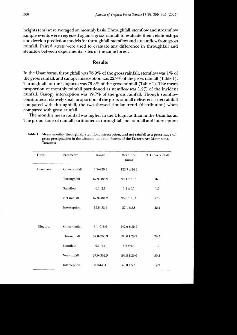
In the Usambaras, throughfallwas 76.9Vo of the gross rainfall, stemflow was l%o ofthe gross rainfall, and canopy interceptionwas 22SVo of the gross rainfall (Table 1) .
Throughfall for the Ulugurus was79.3Vo of the gross rainfall (Table 1). The meanproportion of monthly rainfall partitioned as stemflow was l.ZVo of the incidentrainfall. Canopy interception was 19.7Vo of the gross rainfall. Though stemflowconstitutes a relatively small proportion of the gross rainfall delivered as net rainfallcompared with throughfall, the two showed similar trend (distribution) whencompared with gross rainfall.
The monthly mean rainfall was higher in the Ulugurus than in the Usambaras.The proportions of rainfall partitioned as throughfall, net rainfall and interception
Table I Mean monthly throughfall, stemflow, interception, and net rainfall as a percentage ofgross precipitation in the afromontane rain forests of the Eastern Arc Mountains,Tanzania
Forest Parameter Range Mean + SE
(mm)7o Gross rainfall
Usambara
Uluguru
Gross rainfall
Throughfall
Stemflow
Net rainfall
Interception
Gross rainfall
Throughfall
Stemflow
Net rainfall
Interception
L.9429.3
67.9-183.9
0.1-2.1
67.9-184.2
15.8-32.1
3. 1-916.9
37.0-266.9
0.1-4.4
37.U302.3
0.0-62.4
122.7 + 24.6
94.4+ 21.3
1.2 t 0.1
95.6 + 2L.4
27.1+ 3.8
247.9 + 32.2
196.6 + 29.2
3.2 + 0.5
199.8 + 29.6
48.8 + 5.5
76.9
1.0
77.9
22.r
79.3
r.2
80.5
L9.7

Journal of Tropical Forest Science 17 (3): 355-365 (2005) 361
did not differ much between the two forests (Table 1). Stemflow contributesrelatively small amounts of water (about 7%) to the forest floors in both forests.Table 2 shows that generally, all sites within the same forest had significantdifferences in throughfall and stemflow (p < 0.05). Both throughfall and stemflowshowed similar increasing trends with increasing amount of monthly precipitation.Throughfall and stemflow were relatively more variable with low rainfall events.Low rainfall events were also among those with relatively high amounts ofthroughfall.
Net rainfall is the remainder of the gross rainfall delivered to the forest floorafter canopy interception. This proportion was higher in the Ulugurus than in theUsambaras (Table 1). Canopy interception was higher in the Usambaras despitelower stem density (988 + 376 stems per hr1) than in the Ulugurus (1164 + 397stems per hrl). Both forests had similar diameter distribution (25 !6 cm dbh inthe Usambaras and 22+2 cm in the Ulugurus).
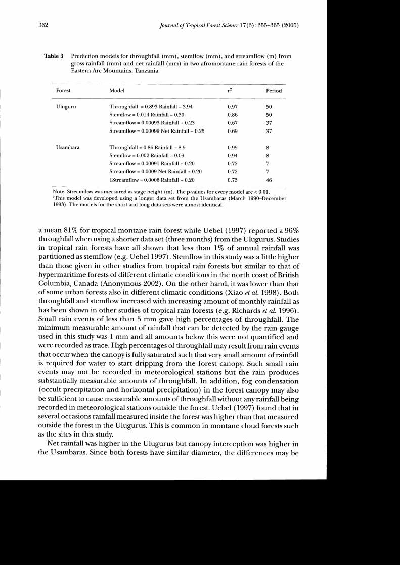
Regression of monthly throughfall and stemflow against gross precipitationshowed a significant linear relationship in both forests (Table 3). Individual monthlymean rainfall events showed no correlation with streamflow. Streamflow was bestmodelled using five year running average rainfall in the Ulugurus and three tofouryears in the Usambaras. Both gross rainfall and netrainfall showed significantlinear relationship with streamflow (p < 0.01) (Table 3). In the Usambaras, theprediction model for streamflow from rainfall developed from a short period ofseven months data set was almost identical to the one developed from a longerperiod of three years (Table 3).
Discussion
The distribution of precipitation followed the long-term distribution patterns typicalof the study sites with bimodal annual rainfall patterns. The average proportionsof the incident rainfall partitioned as throughfall,79.37o for the Ulugurus and76-9% for the Usambaras, are close to those given by other studies for montaneand lowland tropical rain forests; e.g. in a study long enough to account for seasonalvariations in storm patterns and/or vegetation status, Bruijnzeel (1990) reported
Table 2 Paired Ftest (pvalues) showing within forest differences in throughfall and stemflow intwo afromontane rain foress of the Eastern Arc Mountains, Tanzania
Forest Throughfall Stemflow
Usambara
Uluguru
L &2r&32 8c3
| &2l&32 8c3
0.009
0.020
0.004
0.030
0.050
0.410
0.009
0.010
0.003
< 0.001
< 0.001
0.040
362 Journal of Tropical Forest Science 17 (3) : 355-365 (2005)
Table 3 Prediction models for throughfall (mm), stemflow (mm), and streamflow (m) fromgross rainfall (mm) and net rainfall (mm) in two afromontane rain forests of theEastern Arc Mountains. Tanzania
Forest Model Period
Uluguru Throughfall = 0.893 Rainfall - 3.94
Stemflow = 0.014 Rainfall - 0.30
Streamflow = 0.00093 Rainfall + 0.23
Streamflow = 0.00099 Net Rainfall + 0.25
Throughfall = 0.86 Rainfall - 8.5
Stemflow = 0.002 Rainfall - 0.09
Streamflow = 0.00091 Rainfall + 0.20
Streamflow = 0.0009 Net Rainfall + 0.20
lStreamflow = 0.0006 Rainfall + 0.20
0.97
0.86
0.67
0.69
0.99
0.94
0.72
0.72
0.73
50
50
37
37
8
8
I
7
46
Usambara
Note: Streamflowwas measured as stage height (m). The pralues for every model are < 0.01.rThis model was developed using a longer data set from the Usambaras (March l990-December1993). The models for the short and long data sets were almost identical.
a mean 817o for tropical montane rain forest while Uebel (1997) reported ag6Vothroughfallwhen using a shorter data set (three months) from the Ulugurus. Studiesin tropical rain forests have all shown that less than lVo of annual rainfall waspartitioned as stemflow (e.9. Uebel 1997). Stemflow in this studywas a little higherthan those given in other studies from tropical rain forests but similar to that ofhypermaritime forests of different climatic conditions in the north coast of BritishColumbia, Canada (Anonymous 2002). On the other hand, itwas lower than thatof some urban forests also in different climatic conditions (Xiao et aI.1998). Boththroughfall and stemflow increased with increasing amount of monthly rainfall ashas been shown in other studies of tropical rain forests (e.g. Richards et aL.1996).Small rain events of less than 5 mm gave high percentages of throughfall. Theminimum measurable amount of rainfall that can be detected by the rain gaugeused in this study was 1 mm and all amounts below this were not quantified andwere recorded as trace. High percenrages of throughfall mayresultfrom rain eventsthat occur when the canopy is fully saturated such that very small amount of rainfallis required for water to start dripping from the forest canopy. Such small rainevents may not be recorded in meteorological stations but the rain producessubstantially measurable amounts of throughfall. In addition, fog condensation(occult precipitation and horizontal precipitation) in the forest canopy may alsobe sufficient to cause measurable amounts of throughfall without any rainfall beingrecorded in meteorological stations outside the forest. Uebel (1997) found that inseveral occasions rainfall measured inside the forestwas higher than that measuredoutside the forest in the Ulugurus. This is common in montane cloud forests suchas the sites in this study.
Net rainfall was higher in the Ulugurus but canopy interception was higher inthe Usambaras. Since both forests have similar diameter, the differences mav be

Journal of TropicalForest Science 17(3):355-365 (2005) 363
accounted for by storm characteristics, seasonality and probably tree architecturerather than forest structure. Species composition in the Usambaras was differentfrom the Ulugurus and this may account for tree architectural differences.
Due to their close proximity, the differences in stemflow and throughfall betweendifferent experimental sites within the same forest (vegetation type) as observedin this study cannot be explained by differences in rainfall. A relevant explanationis likely to be variations in forest structure, such as number of stem density anddiameter distribution (Spitdehouse 1998, Anonymous 2002). This means that therewere wide site variations in forest structure within individual forests that can greatlyinfluence variations in throughfall and stemflow between different sites. Otherpossible causes may be tree structural and geometrical differenceS, €.8. verticalstratification and branching geometry. Horizontal precipitation may also accountfor the differences since the study sites are at an elevation where horizontalprecipitation is likely to augment the amount of rainfall. Some investigators have
reported less stemflow in large diameter trees compared with small diameter treesin tropical rain forests (e.g. Uebel 1997).
The interception figures observed in this study are higher than those reportedin other studies for tropical rain forests (e.g. Lu & Tang 1995, Asdak et al.I99Ba,b), but are similar to those of a hypermaritime forest in north coast of BritishColumbia (Anonymous 2002) and a mature poplar-pasture vegetation (Guevara-
Escobar et aL.2000).Monthly rainfall ranged from 1.9-429.3 mm and 3.1-916.9 mm in the Usambaras
and Ulugurus respectively. In our analysis the daily rainfall data were lumped intomonthly means, which may cause inconsistency in the results and conclusionsthereof. The characteristics of individual rain events (peak, intensity and intensityprofiles) are likely to be very different in a 'dry' month compared with a 'wet'month and this has a bearing on the mean monthly rainfall. However, suchinconsistencies may be reduced if a long-term data set was used. This study useddata from observations of over 36 months; we considered this to be long enoughto account for seasonal variations in the parameters though longer period datawould increase the precision. The short data set used in the Usambaras helped toconfirm the consistency of rainfall patterns in the region. The similarities betweenthe model from short and long data sets in the Usambaras confirmed the strengthof the correlation between rainfall and streamflow in these forests, irrespective ofrainfall duration. The strong correlation between rainfall, throughfall and stemflowin the two sites indicated that streamflow can adequately be predicted frommeasurements of rainfall where costs for establishment of stream gauging stationsare prohibitive. Such relationships are enhanced by the presence of the forestvegetation. Interception and the manner in which rainfall is partitioned on theforest canopy is a measure to determine the efficiency of a forest ecosystem tomitigate storm water impacts through reduction of runoff volume and delay peakflows. This is an important characteristic ofvegetation biomes managed forwater/soil conservation and this is true for the Eastern Arc forests.

364 Journal of Tropical Forest Science 17 (3): 355-365 (2005)
Conclusions
Canopy interception accounted for at least20Vo of the rainfall in the Eastern Arcforests. On average, more than 70Vo of the incident rainfall is delivered to theforest floor by throughfall. Stemflow delivered about l%. Tl:'e slow response ofstreamflow with storm events is an indication of the potential of these forests tomitigate storm water impacts by reducing runoff volumes and delaying onset ofpeak flows. The prediction models for throughfall, stemflow, and streamflow arethe first to be developed for the forests of the Eastern Arc Mountains of EastAfrica.The present description and modelling of these processes given here, thoughpreliminary are important for future development and testing of water balancemodels, which can help in resource management planning, especially that relatedto changes in landuse and conservation of water resource. The models may also beuseful in similar forest ecosystems elsewhere in the region. Though variations mayexist, the models developed in this study are good approximations where resourceconstraints prevent extensive studies of the aboveground components of thehydrologic cycle.
Acknowledgments
Financial and material support for this work was given by the Sokoine University ofAgriculture, Morogoro,Tanzania, and the Rockefeller Foundation A-DI Program,USA (Grant RF96022 No. 781). We thank the assistance of the late K Kibwana ofKisosa Village, Uluguru Mountains and his group in field data collection.
References
ANolqwous. 2002. Canopy interception in a hlpermaritime forest on the north coast of BritishColumbia. Extension Note No. +9. nnp//wuw.forgou.bc.ca.rni/Research/Extension_Notes/Enote49.pdf.
Asoer, C., Jaruts, P. G. & GenoINcnu, P. V. 1998a. Modeling rainfall interception in unlogged andIogged forest areas of Central Kalimantan, Indonesia. Hyd,rologic andEarth Systems Sci.ences2(2-3):2ll-220.
Asoe& C.,Janus, P. G., GanoINcnN, P. V. & Fnesrn, A. 1998b. Rainfall interception loss in unlogged andlogged forest areas of Central Kalimantan, Indonesia.rlaumal of Hyd.rohg206:237-244.
BoscH,J. M. 1982. Stream flow response to catchment management in South Africa. Pp. 279-254inProceedings of Symposium on Hydrolngical Rcsearch Basin and Their Use in Watn Resource Pl,anning.Sonderh Landeshydrologic, Bern.
Boscu, J. M. & Hmurr, J. D. 1982. A review of catchment experiments to determine the effect ofvegetation changes on water yield and evapotranspiration.rfozmal of Hydrolng 55: T23.
Bnul;Nznrr, L. A.1990. Hydrolng of MoistTropicalFmests andEffeas ofTheirConausion: AState of l(nowtzdgeRnian. UNESCO International Hydrological Programs: Amsterdam.
Gunvena-Esconen, A., Eowenos, N. R. W., MonroN, H. R., Krrup, D. P. & Mecxev, A.D. 2000. Tree wateruse and rainfall partitioning in a mature poplar-pasture system. Tree Physiolng 20: 97-106.
Hugrs, R. W A., Wrnnoe, A. & VnrN, A. W. L. 1990. Rainfall interception in the Tai forest Ivory Coast:application of two simulation models to humid tropical system. Journal of Hydrotog ll4: 259-275.
Lovrrr,J. C. 1996. Elevational and latitudinal changes in tree associations and diversity in the easternarc mountains of Tanzania. Jaumal of Tropical Ecolng 12: 62$-650.

Journal of Tropical Forest Science 17 (3): 355-365 (2005) 365
Lu, S. & TeNc, IL 1995. Study ofrainfall interception characteristics ofnatural hardwood forests inCentral Taiwan. Bullztin of Thiwan Fmest Rtsearch Institute Nan Series I0 (4): 447-457 .
NonnrN, G. L. & MumsHI, P. I( T. 1995. Tht Catchmznt Forest Project Report. Sokoine University ofAgriculture, Morogoro.
Owtr.rs, K M. 2002. Rainfall partitioning within Juniper Communities. Final Report to the TexasWater Resources Institute. Texas Agriculture Experiment Station, Uvalde Research andextension Center. http//znnt Uaald.e.tamu.eduhtalf/keith/T-WRl2002Vo 20 Report. ptlf.
Pnrcn, M. F. & Brrrr, N. (Eos.) 2000. Fmests in Sustainablz Mountain Dnelopment: A Snte-of-I(noulzdgeReport for 2000. CAB International, Wallingford.
Rtcnems, P. W., Wersu, R. P. D., Banut, I. C. & Gru,Ic-Surnr, P. 1996. The Tropical Rain Forests.2ndedition. Cambridge University Press, Cambridge.
SHIxrorr,raNov, A. I. & KRrstovsIv, L O. 1988. The influence of forests on reclamation practice onstream flow and water balance. Pp. 78-82 in Reynolds R. C., & Thompson, B. F. (Eds.) Fmests,
Climate, and Hydrol.og; Rcgional hnpadrs. United Nations University, Tokyo.Surrnuousn, D. L. 1998. Rainfall interception in young and mature coastal conifer forests. Pp. 4044
in Alila, Y (Ed.) Mountains to Sea: Human Interaction uith the Hyd.rolngical Cyclz. Canadian WaterResources Association, Cambridge.
Urrrr-, J. L997 . Thraughfall and Stemflow in a Montane East African Rainforest. Minor Field Study No 16.Swedish University of Agricultural Sciences, Uppsala.
Xreo, Q., McrurnsoN, G. E. SIIrarrapsoN, R.J. & Usrru, S. 1998. Rainfall interception in Sacramento'surban forest. http//unn Gtars.ucd.aais.ed.u/papers/html/xiaoetall998a papnfrhtml.