Embed Size (px)
Citation preview
UMTS Project Partners | Vincent Le Sage
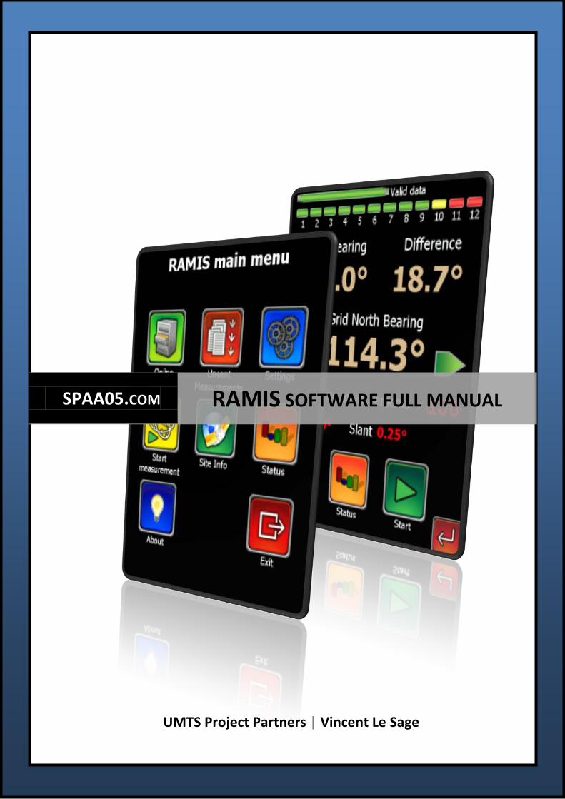
SPAA05.COM RAMIS SOFTWARE FULL MANUAL
SPAA05 RAMIS Software Full Manual
1
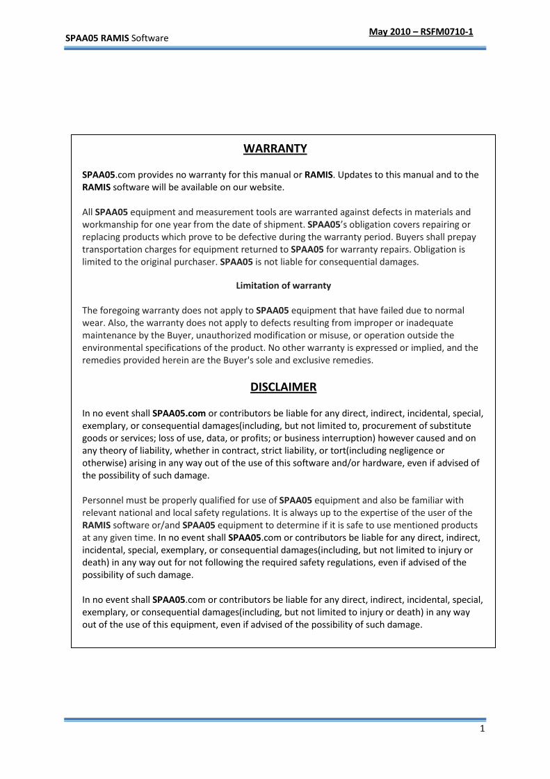
WARRANTY
SPAA05.com provides no warranty for this manual or RAMIS. Updates to this manual and to the RAMIS software will be available on our website. All SPAA05 equipment and measurement tools are warranted against defects in materials and workmanship for one year from the date of shipment. SPAA05’s obligation covers repairing or replacing products which prove to be defective during the warranty period. Buyers shall prepay transportation charges for equipment returned to SPAA05 for warranty repairs. Obligation is limited to the original purchaser. SPAA05 is not liable for consequential damages.
Limitation of warranty
The foregoing warranty does not apply to SPAA05 equipment that have failed due to normal wear. Also, the warranty does not apply to defects resulting from improper or inadequate maintenance by the Buyer, unauthorized modification or misuse, or operation outside the environmental specifications of the product. No other warranty is expressed or implied, and the remedies provided herein are the Buyer's sole and exclusive remedies.
DISCLAIMER
In no event shall SPAA05.com or contributors be liable for any direct, indirect, incidental, special, exemplary, or consequential damages(including, but not limited to, procurement of substitute goods or services; loss of use, data, or profits; or business interruption) however caused and on any theory of liability, whether in contract, strict liability, or tort(including negligence or otherwise) arising in any way out of the use of this software and/or hardware, even if advised of the possibility of such damage. Personnel must be properly qualified for use of SPAA05 equipment and also be familiar with relevant national and local safety regulations. It is always up to the expertise of the user of the RAMIS software or/and SPAA05 equipment to determine if it is safe to use mentioned products at any given time. In no event shall SPAA05.com or contributors be liable for any direct, indirect, incidental, special, exemplary, or consequential damages(including, but not limited to injury or death) in any way out for not following the required safety regulations, even if advised of the possibility of such damage. In no event shall SPAA05.com or contributors be liable for any direct, indirect, incidental, special, exemplary, or consequential damages(including, but not limited to injury or death) in any way out of the use of this equipment, even if advised of the possibility of such damage.
May 2010 – RSFM0710-1
SPAA05 RAMIS Software Full Manual
2
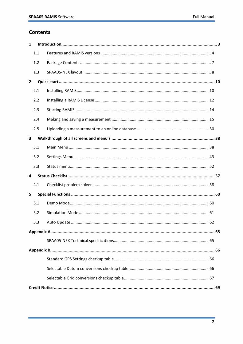
Contents
1 Introduction............................................................................................................................... 3
1.1 Features and RAMIS versions .................................................................................................. 4
1.2 Package Contents .................................................................................................................... 7
1.3 SPAA05-NEX layout.................................................................................................................. 8
2 Quick start ............................................................................................................................... 10
2.1 Installing RAMIS ..................................................................................................................... 10
2.2 Installing a RAMIS License ..................................................................................................... 12
2.3 Starting RAMIS ....................................................................................................................... 14
2.4 Making and saving a measurement ...................................................................................... 15
2.5 Uploading a measurement to an online database ................................................................ 30
3 Walkthrough of all screens and menu’s .................................................................................... 38
3.1 Main Menu ............................................................................................................................ 38
3.2 Settings Menu........................................................................................................................ 43
3.3 Status menu ........................................................................................................................... 52
4 Status Checklist ........................................................................................................................ 57
4.1 Checklist problem solver ....................................................................................................... 58
5 Special Functions ..................................................................................................................... 60
5.1 Demo Mode ........................................................................................................................... 60
5.2 Simulation Mode ................................................................................................................... 61
5.3 Auto Update .......................................................................................................................... 62
Appendix A ..................................................................................................................................... 65
SPAA05-NEX Technical specifications .................................................................................... 65
Appendix B...................................................................................................................................... 66
Standard GPS Settings checkup table .................................................................................... 66
Selectable Datum conversions checkup table ....................................................................... 66
Selectable Grid conversions checkup table ........................................................................... 67
Credit Notice ................................................................................................................................... 69
SPAA05 RAMIS Software Full Manual
3
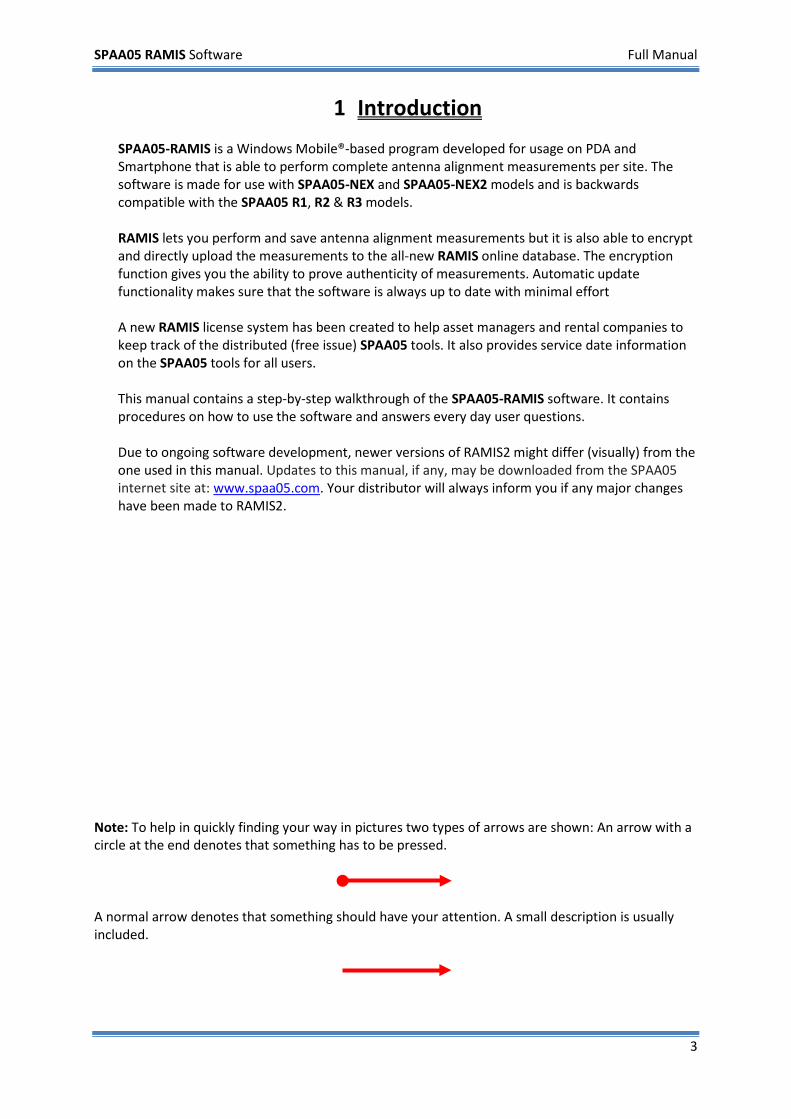
1 Introduction SPAA05-RAMIS is a Windows Mobile®-based program developed for usage on PDA and Smartphone that is able to perform complete antenna alignment measurements per site. The software is made for use with SPAA05-NEX and SPAA05-NEX2 models and is backwards compatible with the SPAA05 R1, R2 & R3 models. RAMIS lets you perform and save antenna alignment measurements but it is also able to encrypt and directly upload the measurements to the all-new RAMIS online database. The encryption function gives you the ability to prove authenticity of measurements. Automatic update functionality makes sure that the software is always up to date with minimal effort A new RAMIS license system has been created to help asset managers and rental companies to keep track of the distributed (free issue) SPAA05 tools. It also provides service date information on the SPAA05 tools for all users. This manual contains a step-by-step walkthrough of the SPAA05-RAMIS software. It contains procedures on how to use the software and answers every day user questions. Due to ongoing software development, newer versions of RAMIS2 might differ (visually) from the one used in this manual. Updates to this manual, if any, may be downloaded from the SPAA05 internet site at: www.spaa05.com. Your distributor will always inform you if any major changes have been made to RAMIS2.
Note: To help in quickly finding your way in pictures two types of arrows are shown: An arrow with a circle at the end denotes that something has to be pressed.
A normal arrow denotes that something should have your attention. A small description is usually included.
SPAA05 RAMIS Software Full Manual
4
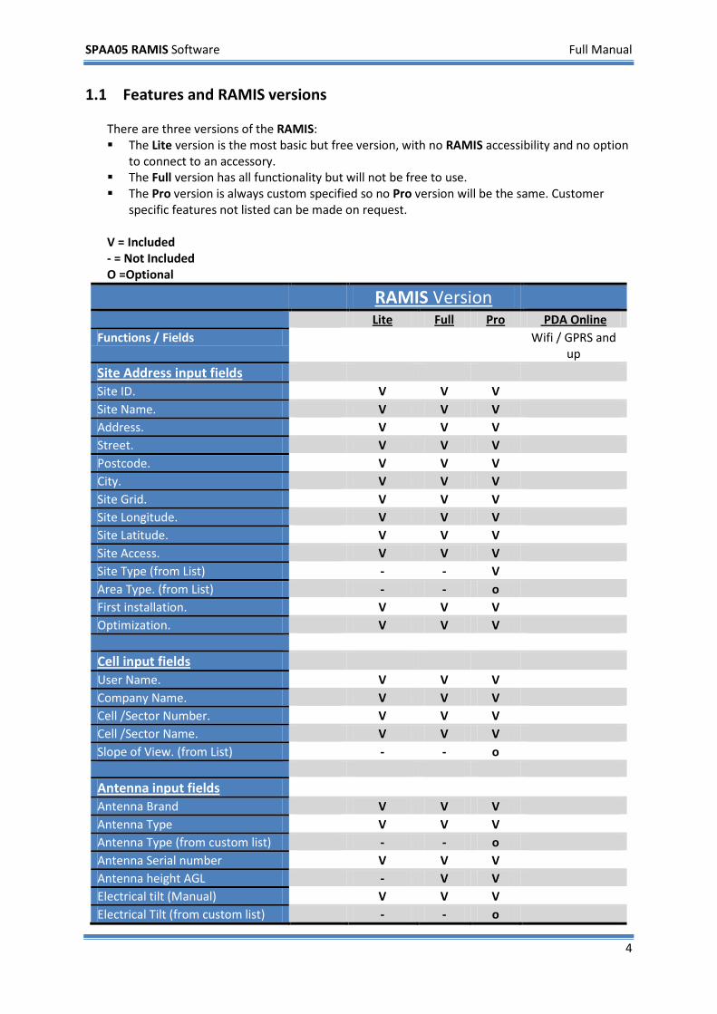
1.1 Features and RAMIS versions There are three versions of the RAMIS: The Lite version is the most basic but free version, with no RAMIS accessibility and no option
to connect to an accessory. The Full version has all functionality but will not be free to use. The Pro version is always custom specified so no Pro version will be the same. Customer
specific features not listed can be made on request. V = Included - = Not Included O =Optional
RAMIS Version Lite Full Pro PDA Online Functions / Fields Wifi / GPRS and
up
Site Address input fields
Site ID. V V V Site Name. V V V Address. V V V Street. V V V Postcode. V V V City. V V V Site Grid. V V V Site Longitude. V V V Site Latitude. V V V Site Access. V V V Site Type (from List) - - V Area Type. (from List) - - o First installation. V V V Optimization. V V V Cell input fields
User Name. V V V Company Name. V V V Cell /Sector Number. V V V Cell /Sector Name. V V V Slope of View. (from List) - - o Antenna input fields
Antenna Brand V V V Antenna Type V V V Antenna Type (from custom list) - - o Antenna Serial number V V V Antenna height AGL - V V Electrical tilt (Manual) V V V Electrical Tilt (from custom list) - - o
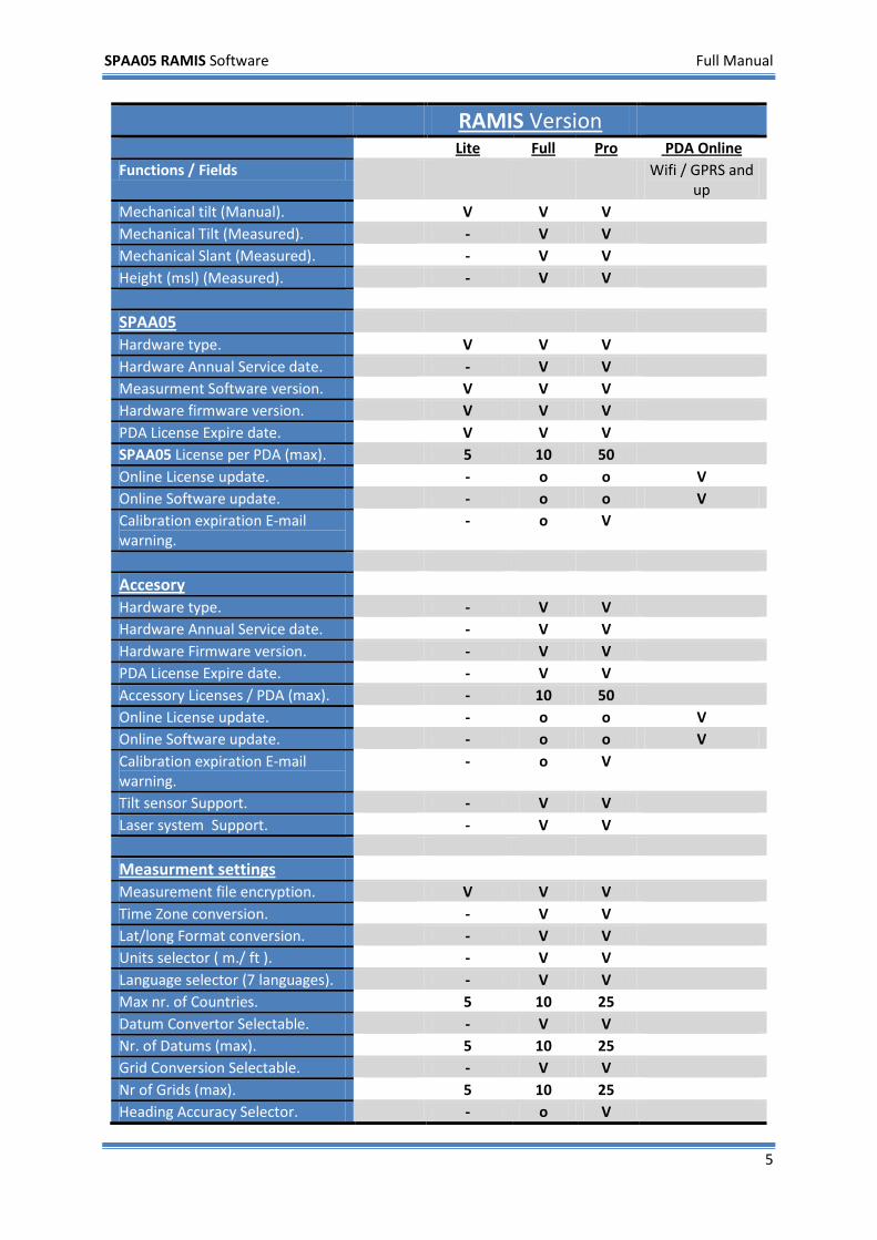
SPAA05 RAMIS Software Full Manual
5
RAMIS Version Lite Full Pro PDA Online Functions / Fields Wifi / GPRS and
up Mechanical tilt (Manual). V V V Mechanical Tilt (Measured). - V V Mechanical Slant (Measured). - V V Height (msl) (Measured). - V V SPAA05
Hardware type. V V V Hardware Annual Service date. - V V Measurment Software version. V V V Hardware firmware version. V V V PDA License Expire date. V V V SPAA05 License per PDA (max). 5 10 50 Online License update. - o o V Online Software update. - o o V Calibration expiration E-mail warning.
- o V
Accesory
Hardware type. - V V Hardware Annual Service date. - V V Hardware Firmware version. - V V PDA License Expire date. - V V Accessory Licenses / PDA (max). - 10 50 Online License update. - o o V Online Software update. - o o V Calibration expiration E-mail warning.
- o V
Tilt sensor Support. - V V Laser system Support. - V V Measurment settings
Measurement file encryption. V V V Time Zone conversion. - V V Lat/long Format conversion. - V V Units selector ( m./ ft ). - V V Language selector (7 languages). - V V Max nr. of Countries. 5 10 25 Datum Convertor Selectable. - V V Nr. of Datums (max). 5 10 25 Grid Conversion Selectable. - V V Nr of Grids (max). 5 10 25 Heading Accuracy Selector. - o V
SPAA05 RAMIS Software Full Manual
6
RAMIS Version Lite Full Pro PDA Online Functions / Fields Wifi / GPRS and
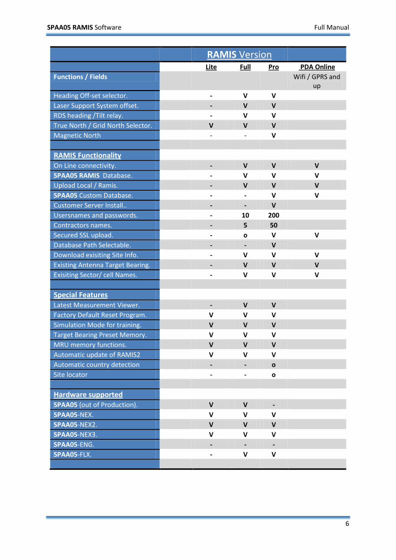
up Heading Off-set selector. - V V Laser Support System offset. - V V RDS heading /Tilt relay. - V V True North / Grid North Selector. V V V Magnetic North - - V RAMIS Functionality
On Line connectivity. - V V V SPAA05 RAMIS Database. - V V V Upload Local / Ramis. - V V V SPAA05 Custom Database. - - V V Customer Server Install.. - - V Usersnames and passwords. - 10 200 Contractors names. - 5 50 Secured SSL upload. - o V V Database Path Selectable. - - V Download exisiting Site Info. - V V V Existing Antenna Target Bearing. - V V V Exisiting Sector/ cell Names. - V V V Special Features
Latest Measurement Viewer. - V V Factory Default Reset Program. V V V Simulation Mode for training. V V V Target Bearing Preset Memory. V V V MRU memory functions. V V V Automatic update of RAMIS2 V V V Automatic country detection - - o Site locator - - o Hardware supported
SPAA05 (out of Production). V V - SPAA05-NEX. V V V SPAA05-NEX2. V V V SPAA05-NEX3. V V V SPAA05-ENG. - - - SPAA05-FLX. - V V
SPAA05 RAMIS Software Full Manual
7
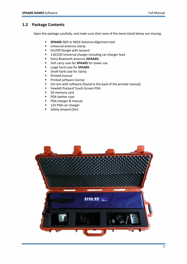
1.2 Package Contents
Open the package carefully, and make sure that none of the items listed below are missing.
SPAA05-NEX or NEX2 Antenna Alignment tool Universal antenna clamp On/Off Dongle with lanyard 110/220 Universal charger including car-charger lead Extra Bluetooth antenna (SPAA05) Soft carry case for SPAA05 for tower use Large hard case for SPAA05 Small hard case for clamp Printed manual Printed software license CD-rom with software (found in the back of the printed manual) Hewlett Packard Touch-Screen PDA SD memory card PDA leather case PDA charger & manual 12V PDA car-charger Safety lanyard (3m)
SPAA05 RAMIS Software Full Manual
8
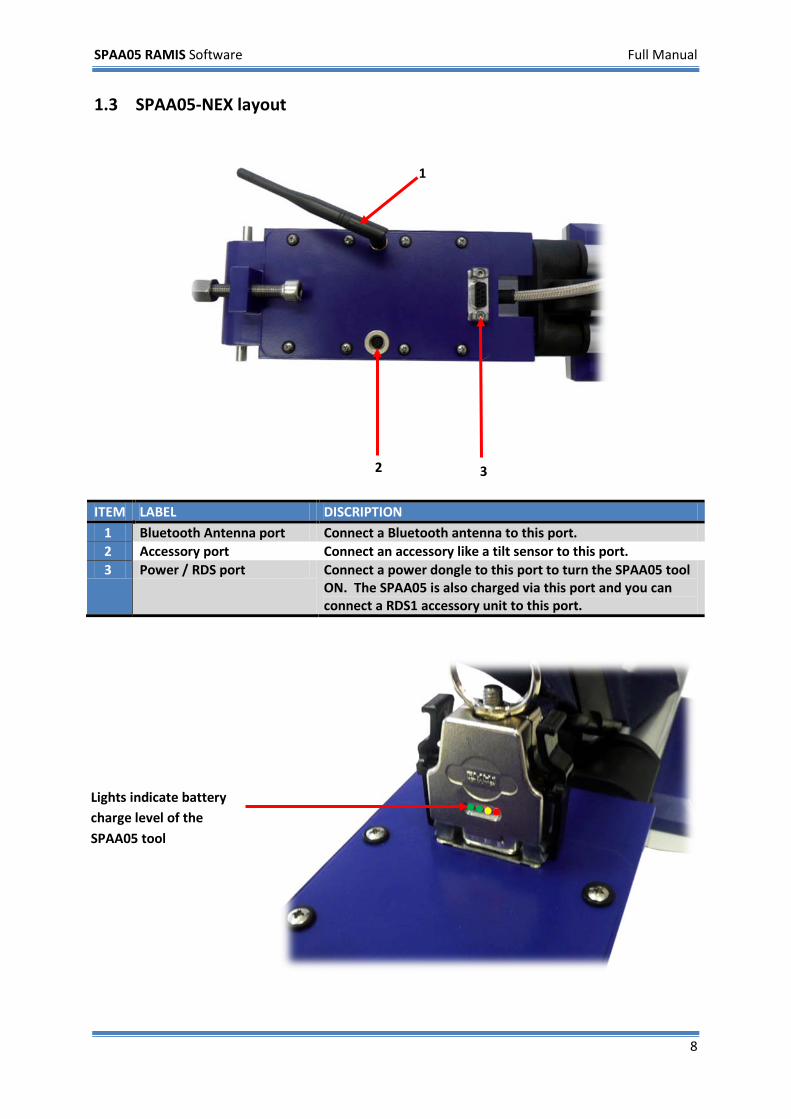
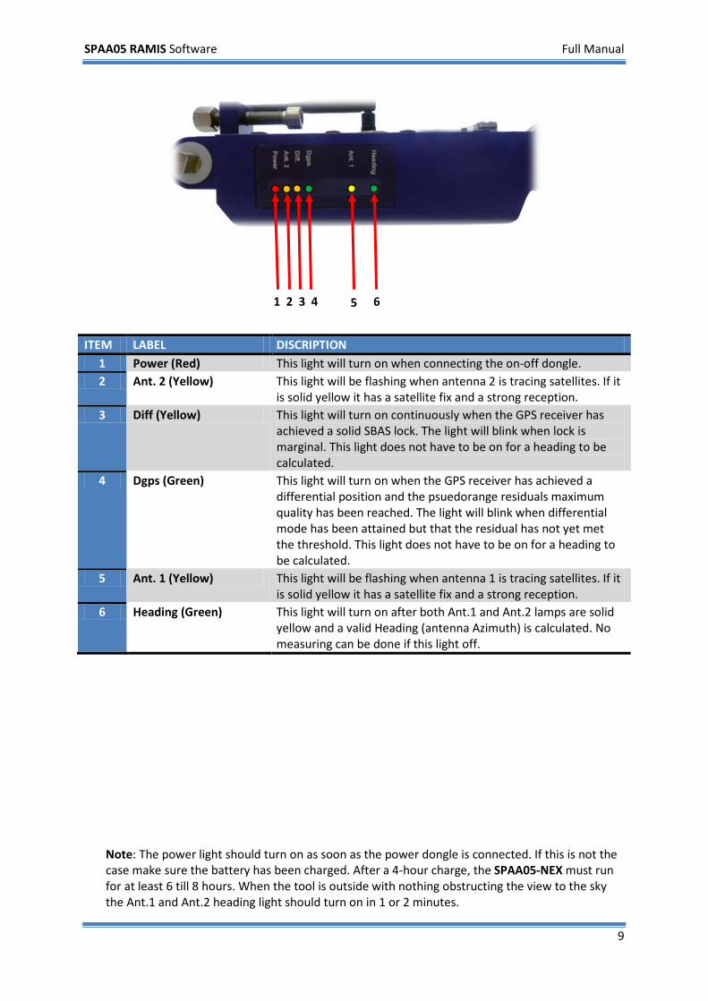
1.3 SPAA05-NEX layout
ITEM LABEL DISCRIPTION 1 Bluetooth Antenna port Connect a Bluetooth antenna to this port. 2 Accessory port Connect an accessory like a tilt sensor to this port. 3 Power / RDS port Connect a power dongle to this port to turn the SPAA05 tool
ON. The SPAA05 is also charged via this port and you can connect a RDS1 accessory unit to this port.
1
2 3
Lights indicate battery charge level of the SPAA05 tool
SPAA05 RAMIS Software Full Manual
9
Note: The power light should turn on as soon as the power dongle is connected. If this is not the case make sure the battery has been charged. After a 4-hour charge, the SPAA05-NEX must run for at least 6 till 8 hours. When the tool is outside with nothing obstructing the view to the sky the Ant.1 and Ant.2 heading light should turn on in 1 or 2 minutes.
ITEM LABEL DISCRIPTION 1 Power (Red) This light will turn on when connecting the on-off dongle. 2 Ant. 2 (Yellow) This light will be flashing when antenna 2 is tracing satellites. If it
is solid yellow it has a satellite fix and a strong reception. 3 Diff (Yellow) This light will turn on continuously when the GPS receiver has
achieved a solid SBAS lock. The light will blink when lock is marginal. This light does not have to be on for a heading to be calculated.
4 Dgps (Green) This light will turn on when the GPS receiver has achieved a differential position and the psuedorange residuals maximum quality has been reached. The light will blink when differential mode has been attained but that the residual has not yet met the threshold. This light does not have to be on for a heading to be calculated.
5 Ant. 1 (Yellow) This light will be flashing when antenna 1 is tracing satellites. If it is solid yellow it has a satellite fix and a strong reception.
6 Heading (Green) This light will turn on after both Ant.1 and Ant.2 lamps are solid yellow and a valid Heading (antenna Azimuth) is calculated. No measuring can be done if this light off.
1 2 3 4 5 6
SPAA05 RAMIS Software Full Manual
10
2 Quick start
2.1 Installing RAMIS
Note: The RAMIS software is pre-installed on every PDA supplied with any new SPAA05 tool. Skip this section and go to section 2.3 - Starting RAMIS - to find out how to start and use the program.
This section is for users installing their version of RAMIS from the enclosed SD memory card. If you want to use ActiveSync® for installing, please follow the Getting Started Guide enclosed with the PDA.
2.1.1 Installing RAMIS
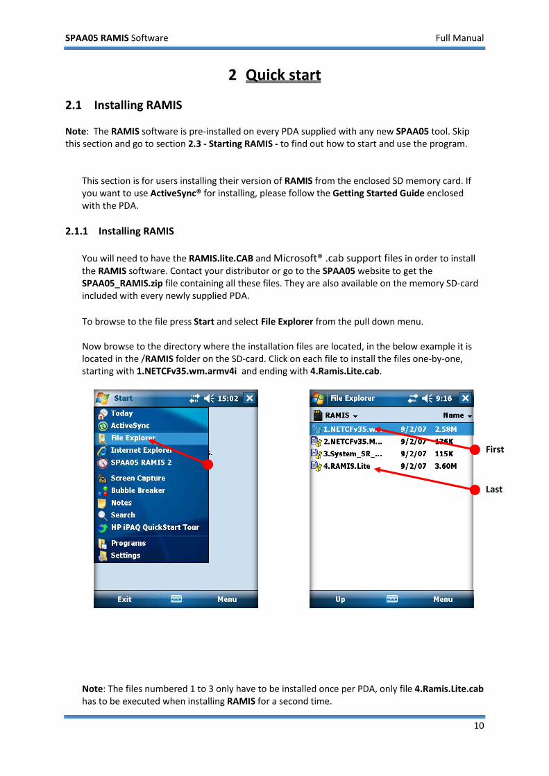
You will need to have the RAMIS.lite.CAB and Microsoft® .cab support files in order to install the RAMIS software. Contact your distributor or go to the SPAA05 website to get the SPAA05_RAMIS.zip file containing all these files. They are also available on the memory SD-card included with every newly supplied PDA. To browse to the file press Start and select File Explorer from the pull down menu. Now browse to the directory where the installation files are located, in the below example it is located in the /RAMIS folder on the SD-card. Click on each file to install the files one-by-one, starting with 1.NETCFv35.wm.armv4i and ending with 4.Ramis.Lite.cab.
Note: The files numbered 1 to 3 only have to be installed once per PDA, only file 4.Ramis.Lite.cab has to be executed when installing RAMIS for a second time.
Last
First
SPAA05 RAMIS Software Full Manual
11
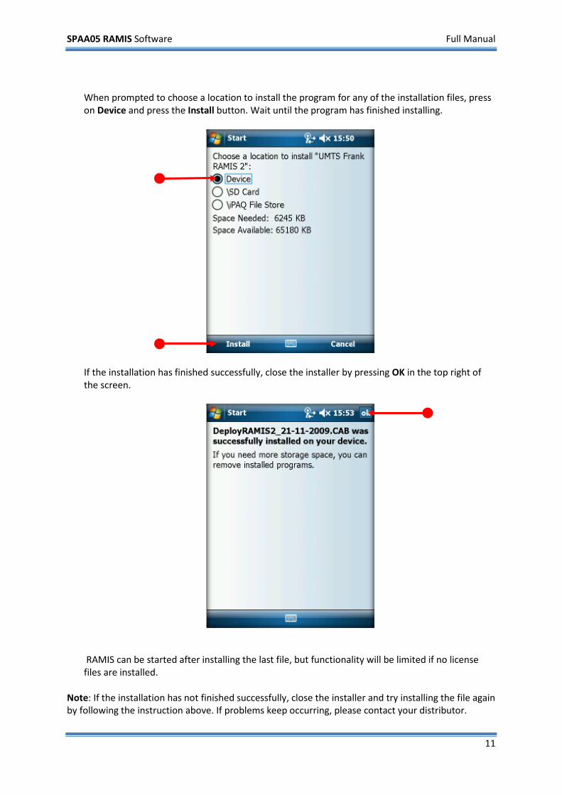
When prompted to choose a location to install the program for any of the installation files, press on Device and press the Install button. Wait until the program has finished installing.
If the installation has finished successfully, close the installer by pressing OK in the top right of the screen.
RAMIS can be started after installing the last file, but functionality will be limited if no license files are installed.
Note: If the installation has not finished successfully, close the installer and try installing the file again by following the instruction above. If problems keep occurring, please contact your distributor.
SPAA05 RAMIS Software Full Manual
12
2.2 Installing a RAMIS License You will need to have a license file installed on the PDA to fully use the RAMIS software. No live measurements can be made without correctly installed license files. Your distributor supplies new and updated license files. The new RAMIS license system helps asset managers and rental companies to keep track of the distributed (free issue) SPAA05 tools and to verify expiry of annual calibration dates. There are three types of licenses: PDA-SPAA05 licenses, feature licenses and accessories licenses. Any newly supplied PDA will have the licenses pre-installed. If a license is missing or has expired, contact your distributor or request a new one from the SPAA05 website.
A PDA license is required to perform measurements and connect to SPAA05 devices. A PDA license is named like license_2GH38S2911.dat. The string 2GH38S2911 is the PDA ID number.
A feature license determines the RAMIS version (Pro, Full or Lite) and available features. A feature license is named license_features.dat.
An accessory license is required to use accessories, like tilt sensors. An accessory license is named license_accessory.dat.
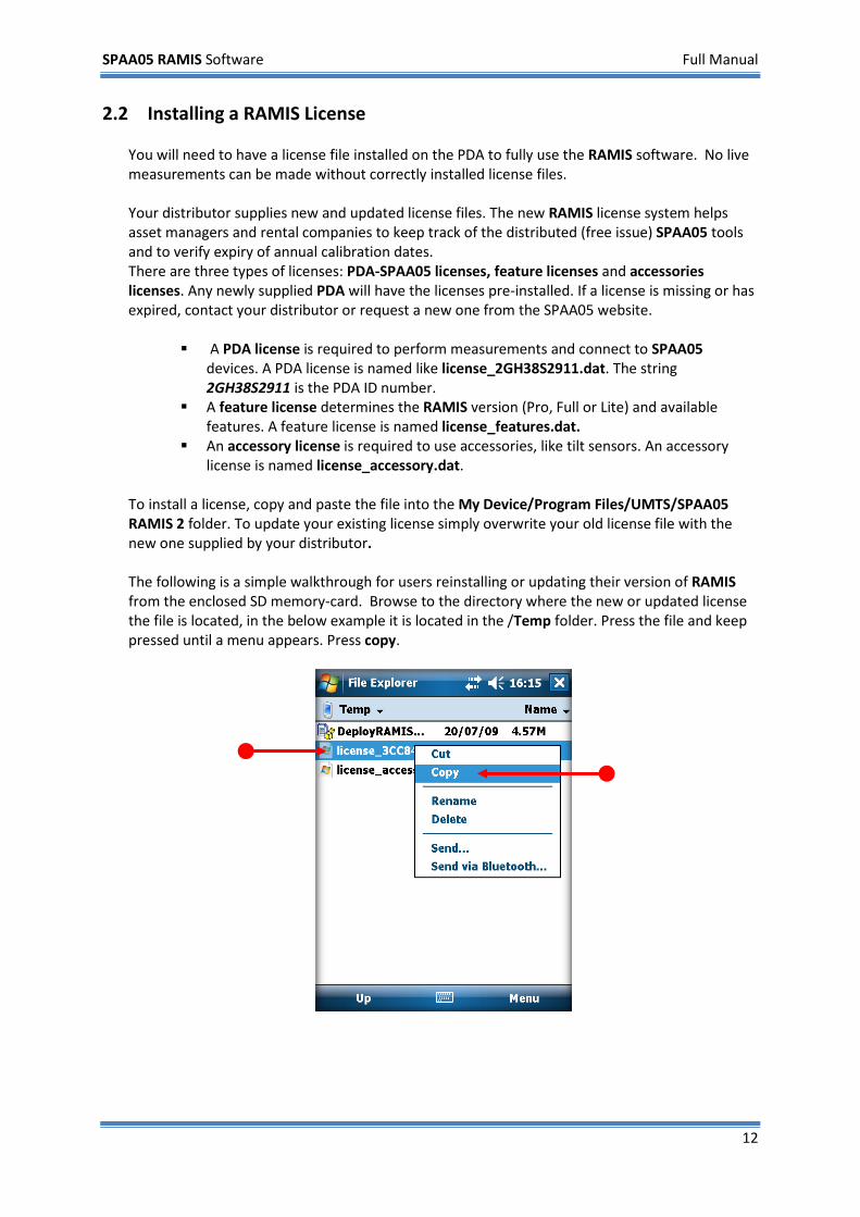
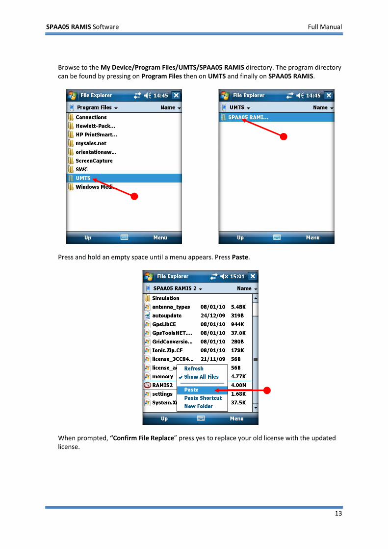
To install a license, copy and paste the file into the My Device/Program Files/UMTS/SPAA05 RAMIS 2 folder. To update your existing license simply overwrite your old license file with the new one supplied by your distributor. The following is a simple walkthrough for users reinstalling or updating their version of RAMIS from the enclosed SD memory-card. Browse to the directory where the new or updated license the file is located, in the below example it is located in the /Temp folder. Press the file and keep pressed until a menu appears. Press copy.
SPAA05 RAMIS Software Full Manual
13
Browse to the My Device/Program Files/UMTS/SPAA05 RAMIS directory. The program directory can be found by pressing on Program Files then on UMTS and finally on SPAA05 RAMIS.
Press and hold an empty space until a menu appears. Press Paste.
When prompted, “Confirm File Replace” press yes to replace your old license with the updated license.
SPAA05 RAMIS Software Full Manual
14
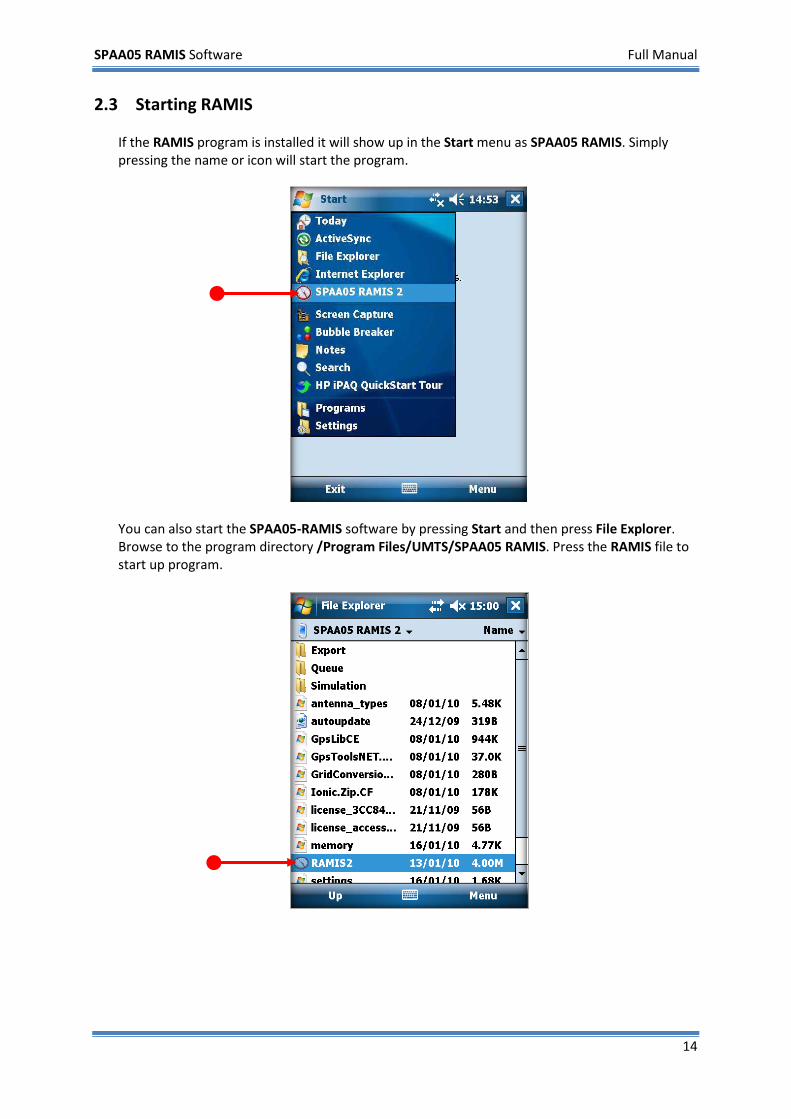
2.3 Starting RAMIS If the RAMIS program is installed it will show up in the Start menu as SPAA05 RAMIS. Simply pressing the name or icon will start the program.
You can also start the SPAA05-RAMIS software by pressing Start and then press File Explorer. Browse to the program directory /Program Files/UMTS/SPAA05 RAMIS. Press the RAMIS file to start up program.
SPAA05 RAMIS Software Full Manual
15
2.4 Making and saving a measurement This section is a step-by-step walkthrough on how to make and save a measurement. The section is written for first time users of the RAMIS software. This walkthrough covers the following:
1) Starting the program. 2) Connecting to the SPAA05 tool. 3) Inputting the site and GPS information. 4) Configuring and starting the measurement. 5) Saving the measurement.
Please refer to chapter 3 for more advanced features of the software.
Note: Before following the instructions make sure the SPAA05 tool is switched ON and is OUTSIDE with a clear view to the sky. Also make sure you have a PIN code ready to enter the program. The PIN code is provided with the license of the SPAA05 tool.
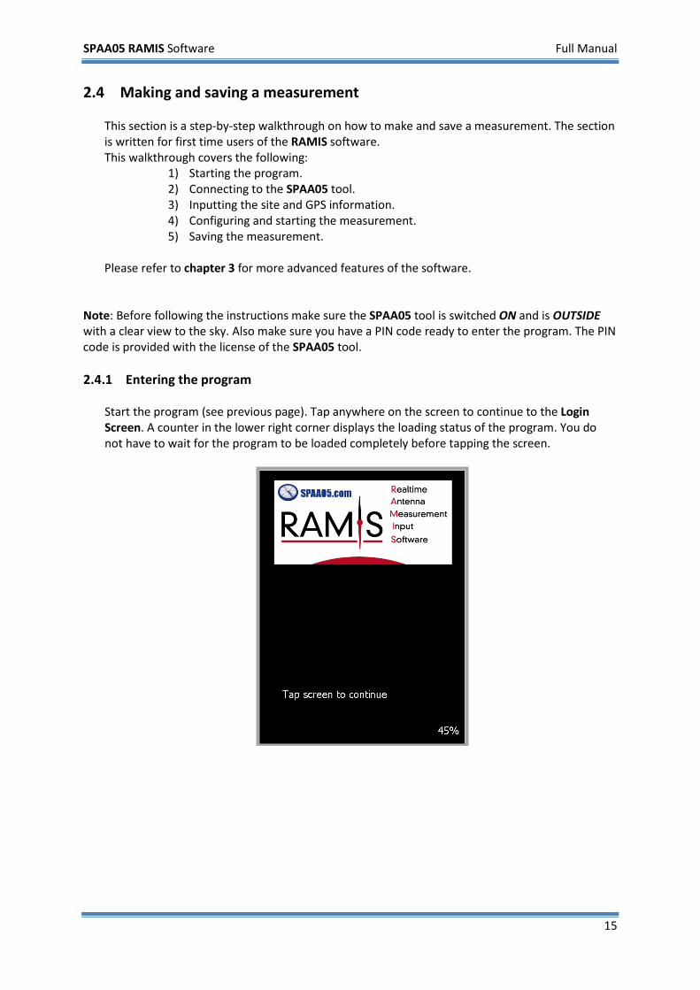
2.4.1 Entering the program
Start the program (see previous page). Tap anywhere on the screen to continue to the Login Screen. A counter in the lower right corner displays the loading status of the program. You do not have to wait for the program to be loaded completely before tapping the screen.
SPAA05 RAMIS Software Full Manual
16
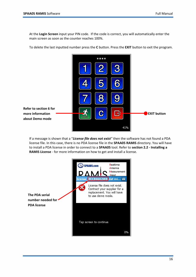
At the Login Screen input your PIN code. If the code is correct, you will automatically enter the main screen as soon as the counter reaches 100%. To delete the last inputted number press the C button. Press the EXIT button to exit the program.
If a message is shown that a “License file does not exist” then the software has not found a PDA license file. In this case, there is no PDA license file in the SPAA05 RAMIS directory. You will have to install a PDA license in order to connect to a SPAA05 tool. Refer to section 2.2 - Installing a RAMIS License - for more information on how to get and install a license.
EXIT button Refer to section 6 for more information about Demo mode
The PDA serial number needed for PDA license
SPAA05 RAMIS Software Full Manual
17
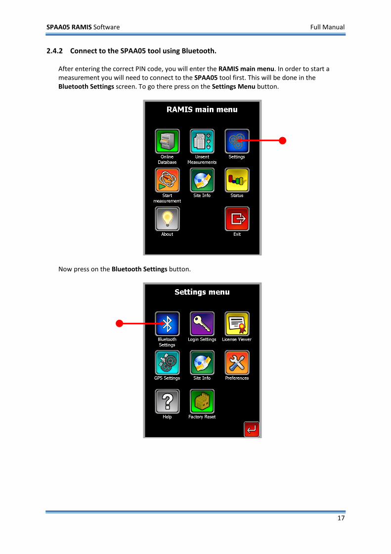
2.4.2 Connect to the SPAA05 tool using Bluetooth. After entering the correct PIN code, you will enter the RAMIS main menu. In order to start a measurement you will need to connect to the SPAA05 tool first. This will be done in the Bluetooth Settings screen. To go there press on the Settings Menu button.
Now press on the Bluetooth Settings button.
SPAA05 RAMIS Software Full Manual
18
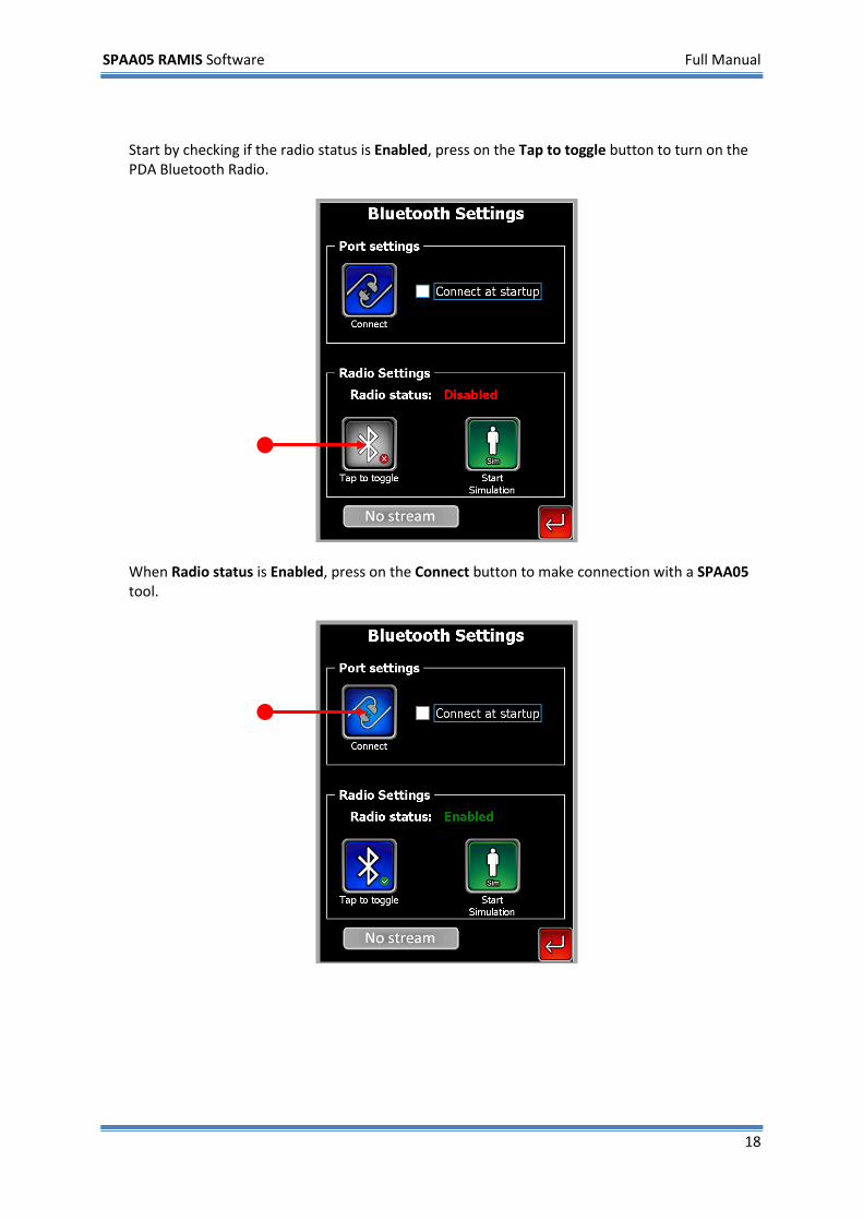
Start by checking if the radio status is Enabled, press on the Tap to toggle button to turn on the PDA Bluetooth Radio.
When Radio status is Enabled, press on the Connect button to make connection with a SPAA05 tool.
SPAA05 RAMIS Software Full Manual
19
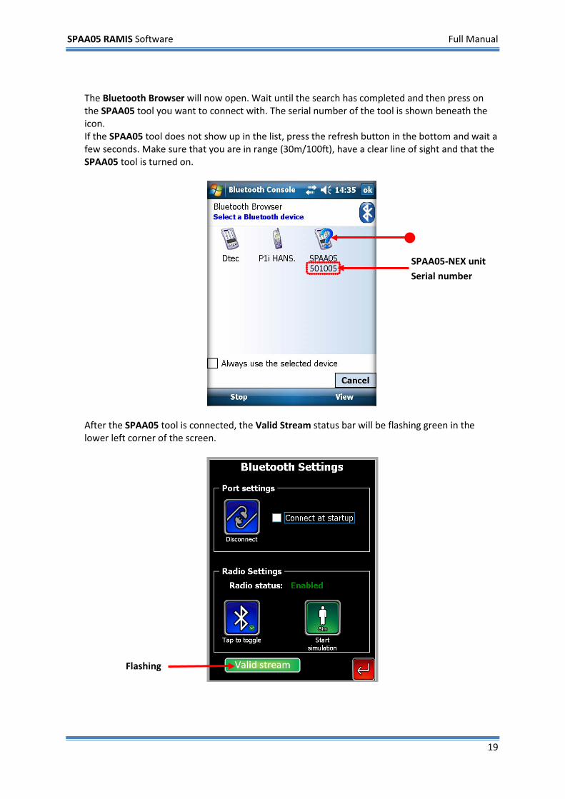
The Bluetooth Browser will now open. Wait until the search has completed and then press on the SPAA05 tool you want to connect with. The serial number of the tool is shown beneath the icon. If the SPAA05 tool does not show up in the list, press the refresh button in the bottom and wait a few seconds. Make sure that you are in range (30m/100ft), have a clear line of sight and that the SPAA05 tool is turned on.
After the SPAA05 tool is connected, the Valid Stream status bar will be flashing green in the lower left corner of the screen.
Flashing
SPAA05-NEX unit Serial number
SPAA05 RAMIS Software Full Manual
20
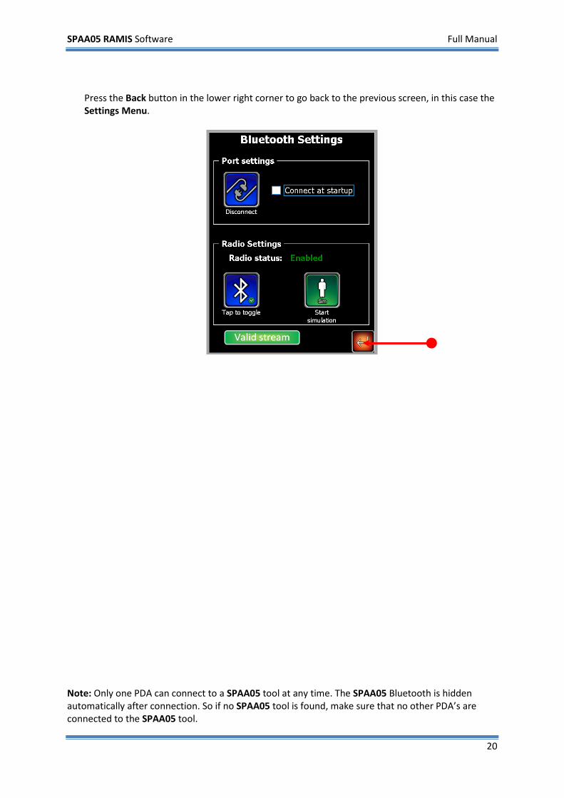
Press the Back button in the lower right corner to go back to the previous screen, in this case the Settings Menu.
Note: Only one PDA can connect to a SPAA05 tool at any time. The SPAA05 Bluetooth is hidden automatically after connection. So if no SPAA05 tool is found, make sure that no other PDA’s are connected to the SPAA05 tool.
SPAA05 RAMIS Software Full Manual
21
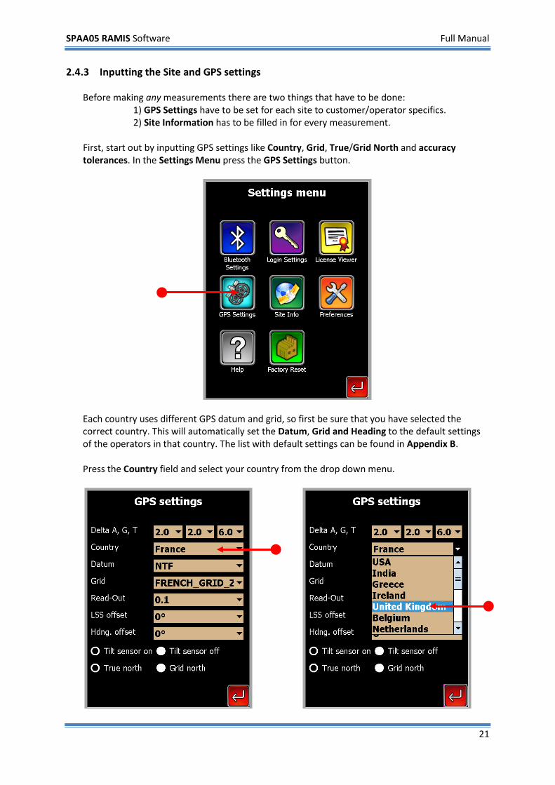
2.4.3 Inputting the Site and GPS settings Before making any measurements there are two things that have to be done:
1) GPS Settings have to be set for each site to customer/operator specifics. 2) Site Information has to be filled in for every measurement.
First, start out by inputting GPS settings like Country, Grid, True/Grid North and accuracy tolerances. In the Settings Menu press the GPS Settings button.
Each country uses different GPS datum and grid, so first be sure that you have selected the correct country. This will automatically set the Datum, Grid and Heading to the default settings of the operators in that country. The list with default settings can be found in Appendix B. Press the Country field and select your country from the drop down menu.
SPAA05 RAMIS Software Full Manual
22
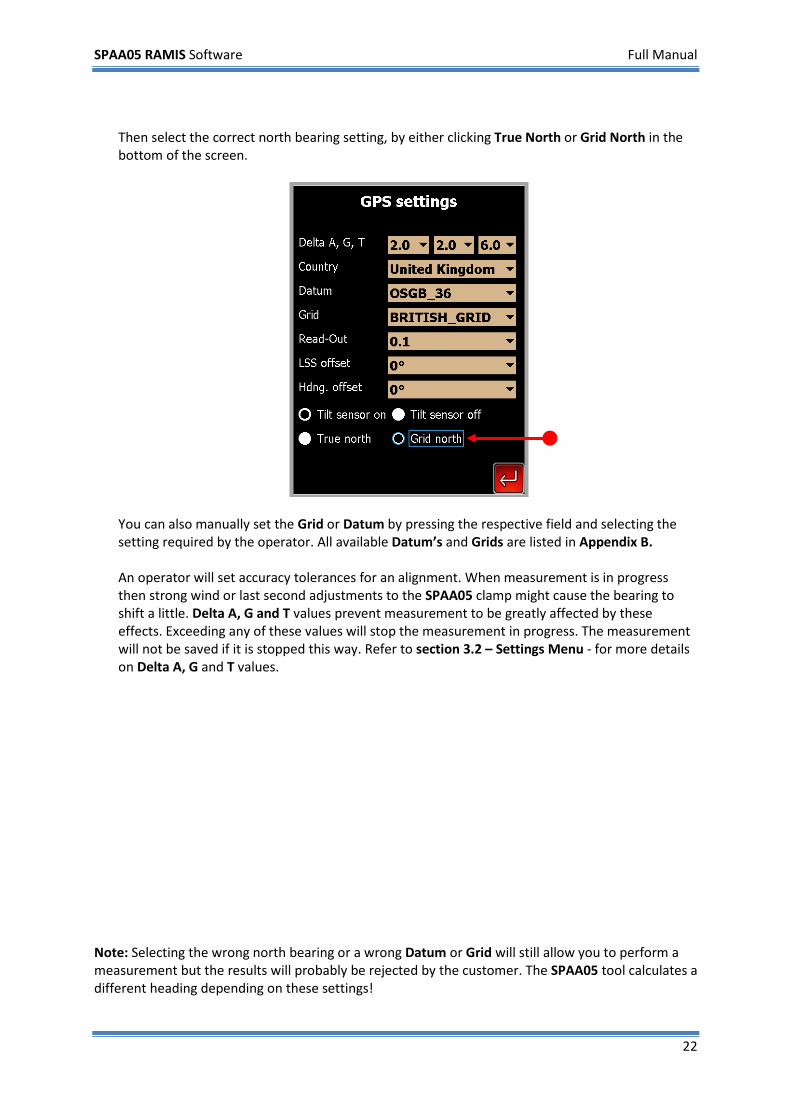
Then select the correct north bearing setting, by either clicking True North or Grid North in the bottom of the screen.
You can also manually set the Grid or Datum by pressing the respective field and selecting the setting required by the operator. All available Datum’s and Grids are listed in Appendix B. An operator will set accuracy tolerances for an alignment. When measurement is in progress then strong wind or last second adjustments to the SPAA05 clamp might cause the bearing to shift a little. Delta A, G and T values prevent measurement to be greatly affected by these effects. Exceeding any of these values will stop the measurement in progress. The measurement will not be saved if it is stopped this way. Refer to section 3.2 – Settings Menu - for more details on Delta A, G and T values.
Note: Selecting the wrong north bearing or a wrong Datum or Grid will still allow you to perform a measurement but the results will probably be rejected by the customer. The SPAA05 tool calculates a different heading depending on these settings!
SPAA05 RAMIS Software Full Manual
23
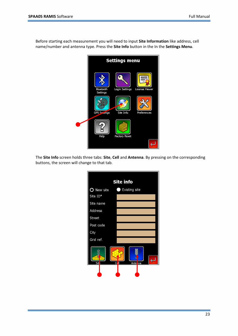
Before starting each measurement you will need to input Site Information like address, cell name/number and antenna type. Press the Site Info button in the In the Settings Menu.
The Site Info screen holds three tabs: Site, Cell and Antenna. By pressing on the corresponding buttons, the screen will change to that tab.
SPAA05 RAMIS Software Full Manual
24
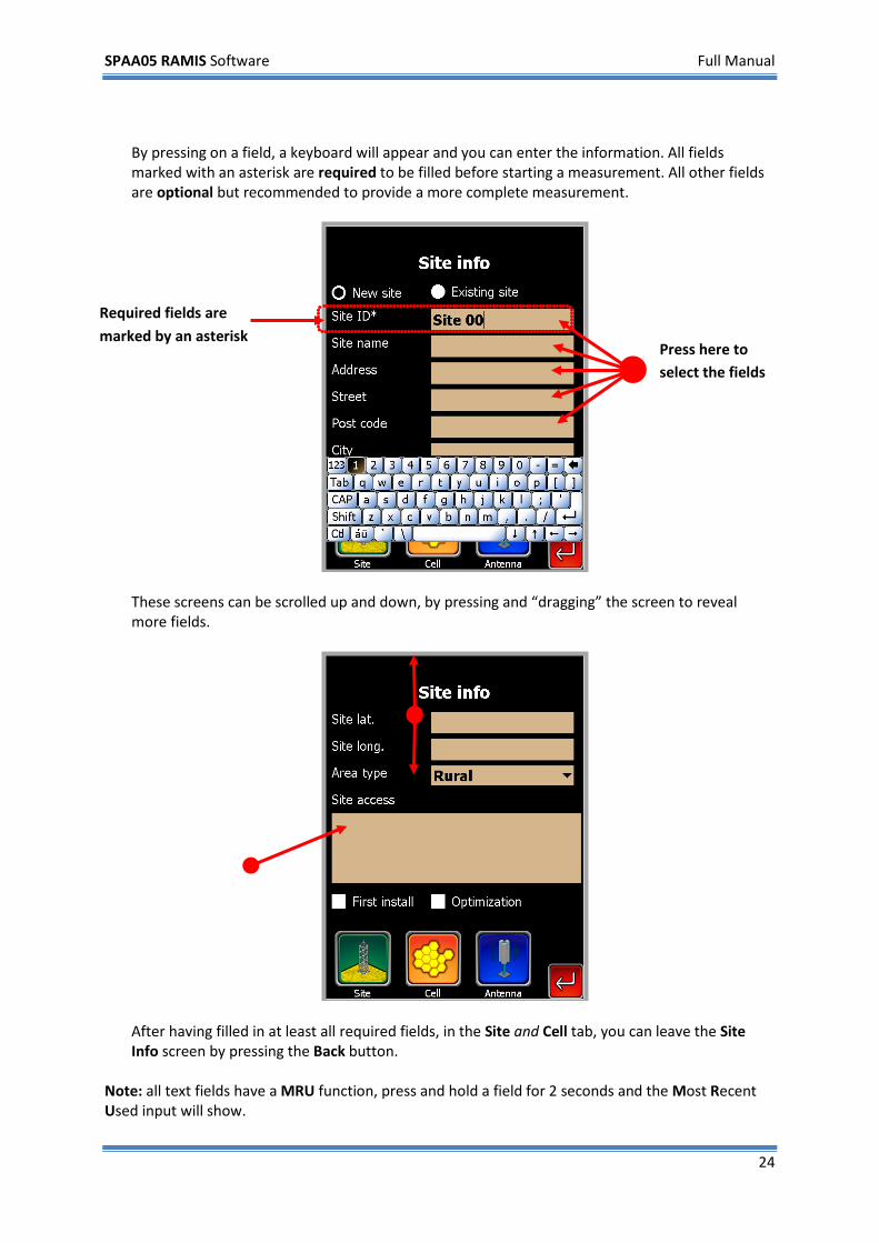
By pressing on a field, a keyboard will appear and you can enter the information. All fields marked with an asterisk are required to be filled before starting a measurement. All other fields are optional but recommended to provide a more complete measurement.
These screens can be scrolled up and down, by pressing and “dragging” the screen to reveal more fields.
After having filled in at least all required fields, in the Site and Cell tab, you can leave the Site Info screen by pressing the Back button.
Note: all text fields have a MRU function, press and hold a field for 2 seconds and the Most Recent Used input will show.
Required fields are marked by an asterisk
Press here to select the fields
SPAA05 RAMIS Software Full Manual
25
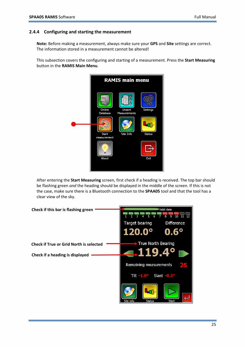
2.4.4 Configuring and starting the measurement Note: Before making a measurement, always make sure your GPS and Site settings are correct. The information stored in a measurement cannot be altered! This subsection covers the configuring and starting of a measurement. Press the Start Measuring button in the RAMIS Main Menu.
After entering the Start Measuring screen, first check if a heading is received. The top bar should be flashing green and the heading should be displayed in the middle of the screen. If this is not the case, make sure there is a Bluetooth connection to the SPAA05 tool and that the tool has a clear view of the sky.
Check if a heading is displayed
Check if this bar is flashing green
Check if True or Grid North is selected
SPAA05 RAMIS Software Full Manual
26
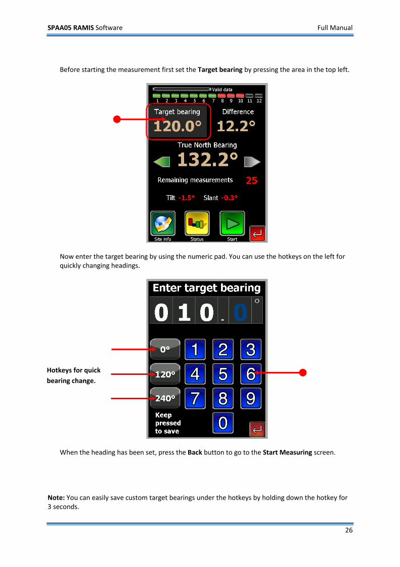
Before starting the measurement first set the Target bearing by pressing the area in the top left.
Now enter the target bearing by using the numeric pad. You can use the hotkeys on the left for quickly changing headings.
When the heading has been set, press the Back button to go to the Start Measuring screen.
Note: You can easily save custom target bearings under the hotkeys by holding down the hotkey for 3 seconds.
Hotkeys for quick bearing change.
SPAA05 RAMIS Software Full Manual
27
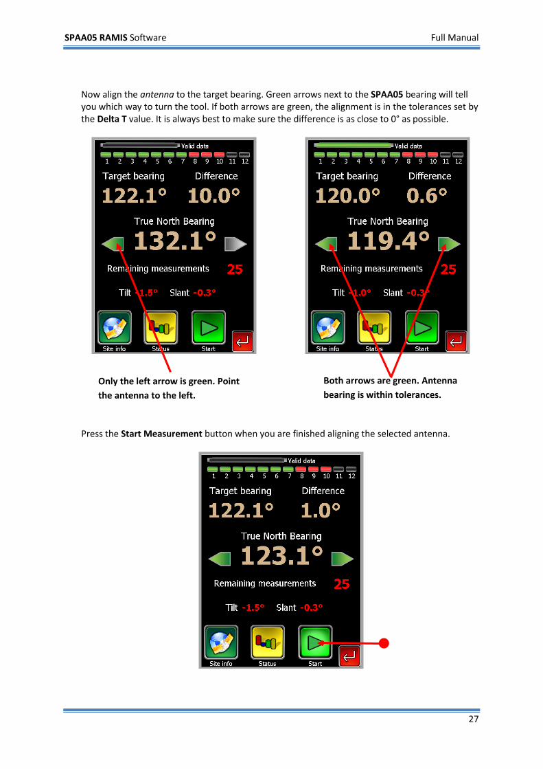
Now align the antenna to the target bearing. Green arrows next to the SPAA05 bearing will tell you which way to turn the tool. If both arrows are green, the alignment is in the tolerances set by the Delta T value. It is always best to make sure the difference is as close to 0° as possible.
Press the Start Measurement button when you are finished aligning the selected antenna.
Both arrows are green. Antenna bearing is within tolerances.
Only the left arrow is green. Point the antenna to the left.
SPAA05 RAMIS Software Full Manual
28
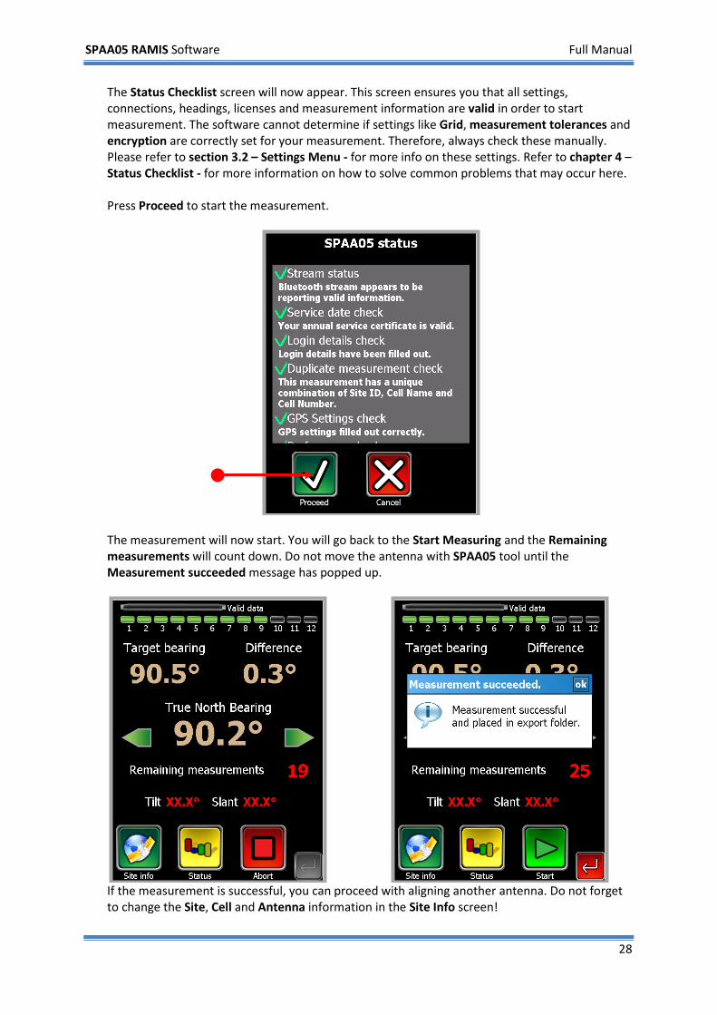
The Status Checklist screen will now appear. This screen ensures you that all settings, connections, headings, licenses and measurement information are valid in order to start measurement. The software cannot determine if settings like Grid, measurement tolerances and encryption are correctly set for your measurement. Therefore, always check these manually. Please refer to section 3.2 – Settings Menu - for more info on these settings. Refer to chapter 4 – Status Checklist - for more information on how to solve common problems that may occur here. Press Proceed to start the measurement.
The measurement will now start. You will go back to the Start Measuring and the Remaining measurements will count down. Do not move the antenna with SPAA05 tool until the Measurement succeeded message has popped up.
If the measurement is successful, you can proceed with aligning another antenna. Do not forget to change the Site, Cell and Antenna information in the Site Info screen!
SPAA05 RAMIS Software Full Manual
29
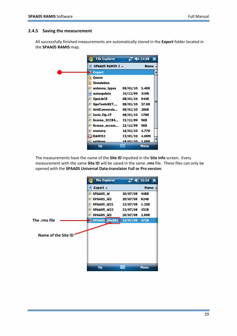
2.4.5 Saving the measurement All successfully finished measurements are automatically stored in the Export folder located in the SPAA05 RAMIS map.
The measurements have the name of the Site ID inputted in the Site Info screen. Every measurement with the same Site ID will be saved in the same .rms file. These files can only be opened with the SPAA05 Universal Data-translator Full or Pro version.
The .rms file
Name of the Site ID
SPAA05 RAMIS Software Full Manual
30
2.5 Uploading a measurement to an online database This section is a step-by-step walkthrough on how to upload a measurement. You can only upload measurements when using either the Full or the Pro version of the RAMIS software. This walkthrough covers the following:
1) Selecting an online database 2) Login to the database 3) Uploading a measurement with RAMIS 2 4) View a measurement in the database
Before using this walkthrough make sure you have read the Making and Saving a measurement and/or know the procedure on how to make a measurement. Also, make sure that the PDA has connection to internet. You will need a valid SPAA05-RAMIS Username, Company and Password to login to your online measurement database. Your company’s database administrator provides this information.
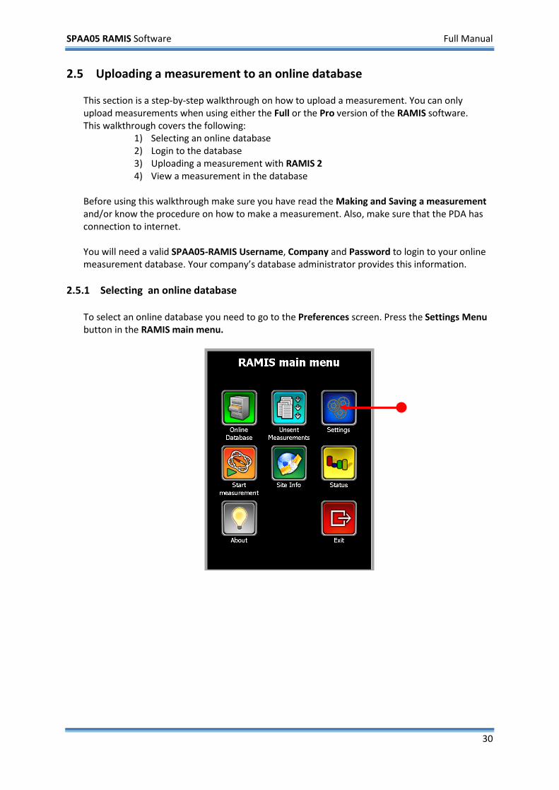
2.5.1 Selecting an online database To select an online database you need to go to the Preferences screen. Press the Settings Menu button in the RAMIS main menu.
SPAA05 RAMIS Software Full Manual
31
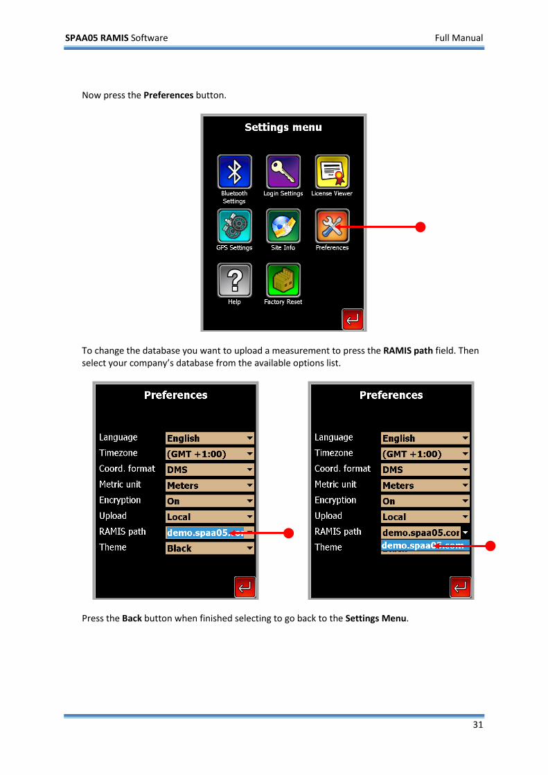
Now press the Preferences button.
To change the database you want to upload a measurement to press the RAMIS path field. Then select your company’s database from the available options list.
Press the Back button when finished selecting to go back to the Settings Menu.
SPAA05 RAMIS Software Full Manual
32
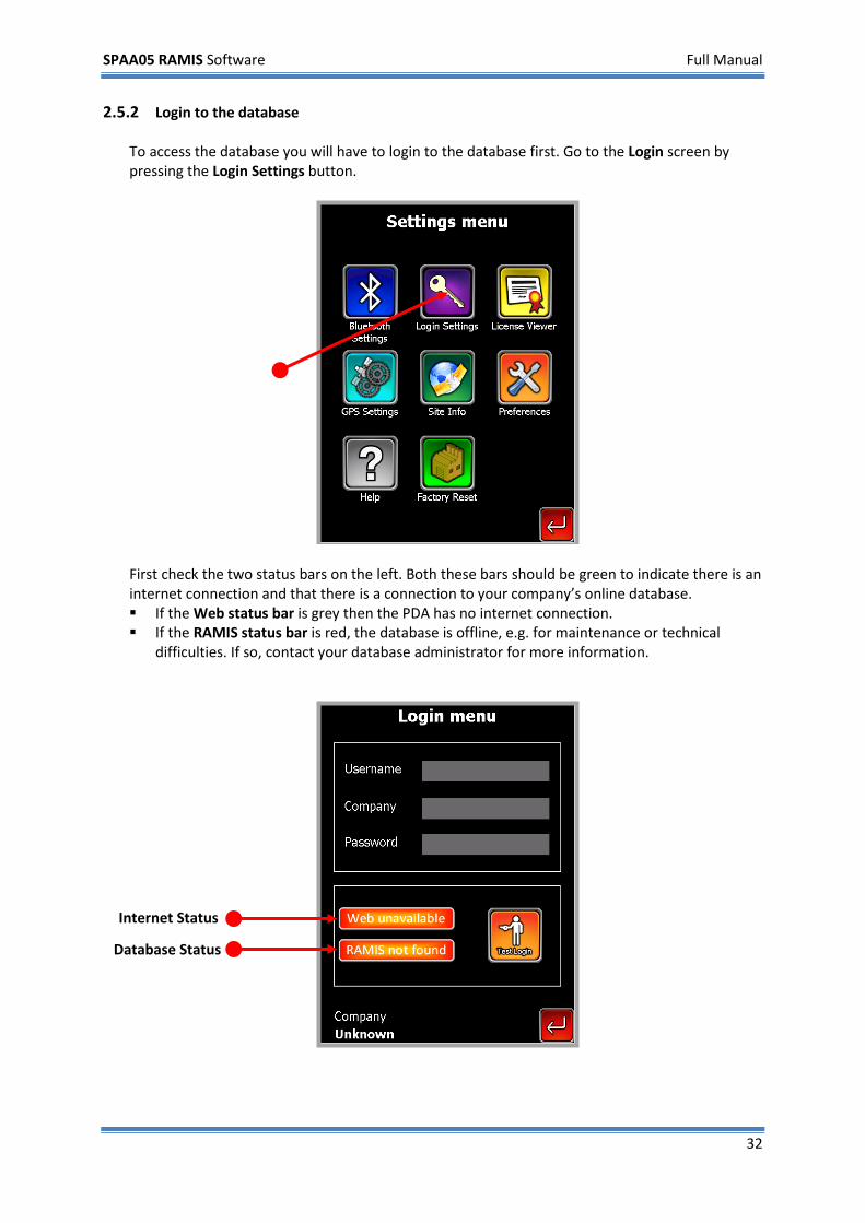
2.5.2 Login to the database To access the database you will have to login to the database first. Go to the Login screen by pressing the Login Settings button.
First check the two status bars on the left. Both these bars should be green to indicate there is an internet connection and that there is a connection to your company’s online database. If the Web status bar is grey then the PDA has no internet connection. If the RAMIS status bar is red, the database is offline, e.g. for maintenance or technical
difficulties. If so, contact your database administrator for more information.
Internet Status
Database Status
SPAA05 RAMIS Software Full Manual
33
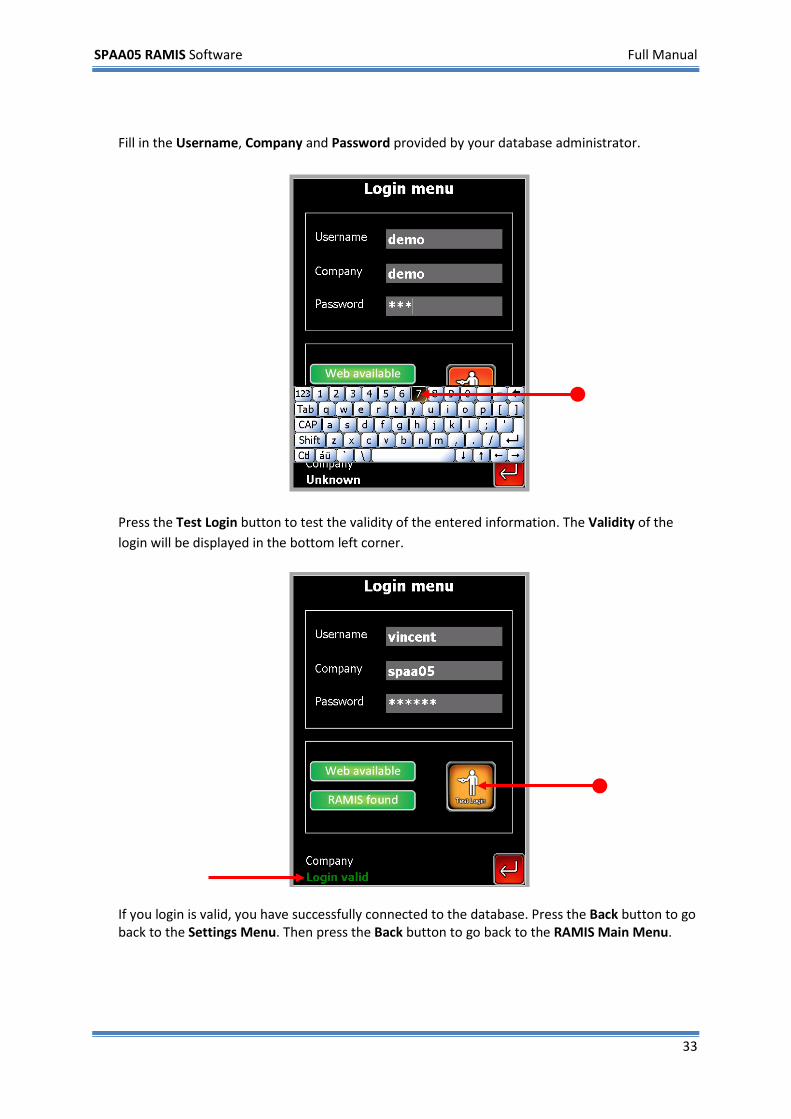
Fill in the Username, Company and Password provided by your database administrator.
Press the Test Login button to test the validity of the entered information. The Validity of the login will be displayed in the bottom left corner.
If you login is valid, you have successfully connected to the database. Press the Back button to go back to the Settings Menu. Then press the Back button to go back to the RAMIS Main Menu.
SPAA05 RAMIS Software Full Manual
34
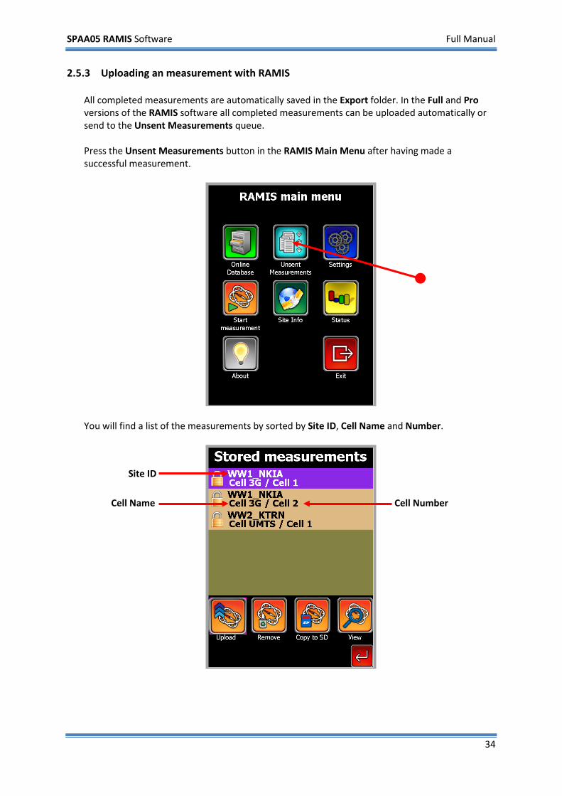
2.5.3 Uploading an measurement with RAMIS All completed measurements are automatically saved in the Export folder. In the Full and Pro versions of the RAMIS software all completed measurements can be uploaded automatically or send to the Unsent Measurements queue. Press the Unsent Measurements button in the RAMIS Main Menu after having made a successful measurement.
You will find a list of the measurements by sorted by Site ID, Cell Name and Number.
Site ID
Cell Name
Cell Number
SPAA05 RAMIS Software Full Manual
35
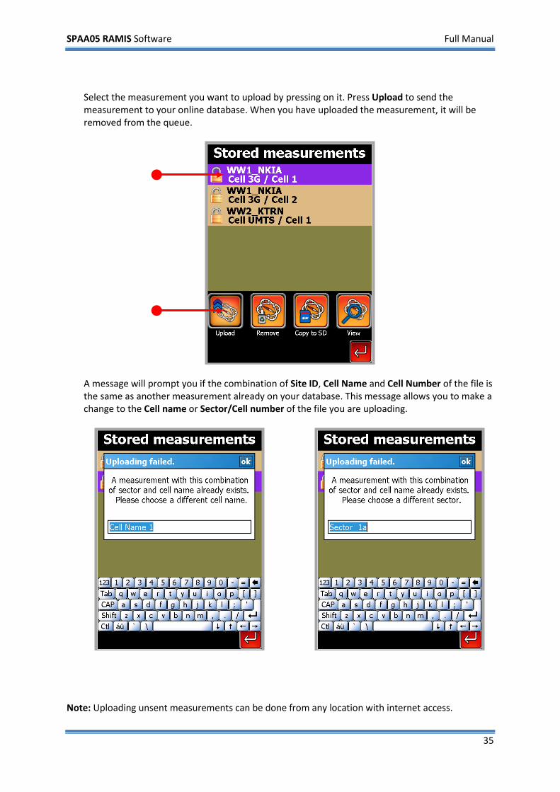
Select the measurement you want to upload by pressing on it. Press Upload to send the measurement to your online database. When you have uploaded the measurement, it will be removed from the queue.
A message will prompt you if the combination of Site ID, Cell Name and Cell Number of the file is the same as another measurement already on your database. This message allows you to make a change to the Cell name or Sector/Cell number of the file you are uploading.
Note: Uploading unsent measurements can be done from any location with internet access.
SPAA05 RAMIS Software Full Manual
36
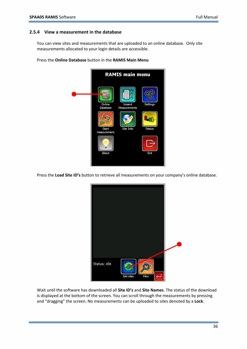
2.5.4 View a measurement in the database You can view sites and measurements that are uploaded to an online database. Only site measurements allocated to your login details are accessible. Press the Online Database button in the RAMIS Main Menu
Press the Load Site ID’s button to retrieve all measurements on your company’s online database.
Wait until the software has downloaded all Site ID’s and Site Names. The status of the download is displayed at the bottom of the screen. You can scroll through the measurements by pressing and “dragging” the screen. No measurements can be uploaded to sites denoted by a Lock.
SPAA05 RAMIS Software Full Manual
37
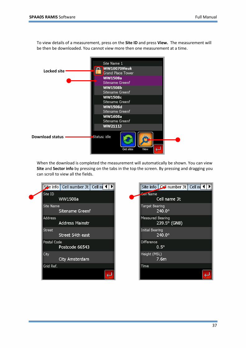
To view details of a measurement, press on the Site ID and press View. The measurement will be then be downloaded. You cannot view more then one measurement at a time.
When the download is completed the measurement will automatically be shown. You can view Site and Sector info by pressing on the tabs in the top the screen. By pressing and dragging you can scroll to view all the fields.
Locked site
Download status
SPAA05 RAMIS Software Full Manual
38
3 Walkthrough of all screens and menu’s This chapter covers all the sections and menus in the RAMIS software. Descriptions of all settings and buttons in the program can be found here. Some sections and settings are not available to the RAMIS Lite version and are only accessible in the Full and Pro versions. These screen sections are denoted by [*].
3.1 Main Menu
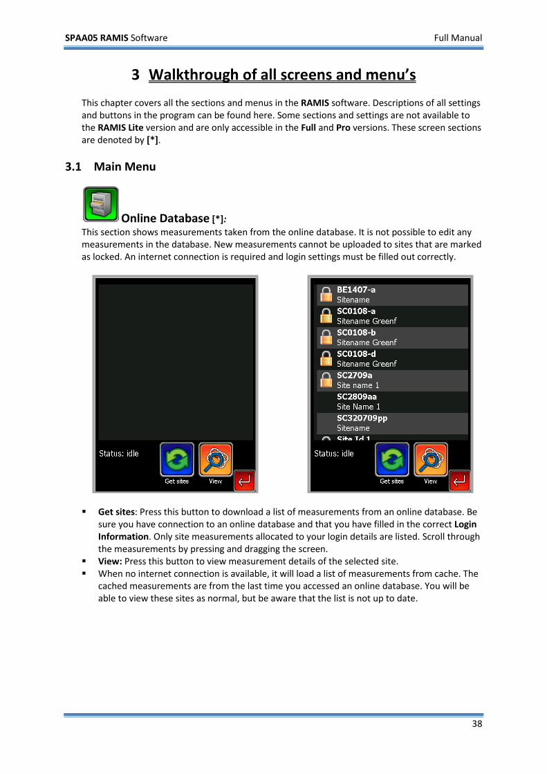
Online Database [*]: This section shows measurements taken from the online database. It is not possible to edit any measurements in the database. New measurements cannot be uploaded to sites that are marked as locked. An internet connection is required and login settings must be filled out correctly.
Get sites: Press this button to download a list of measurements from an online database. Be
sure you have connection to an online database and that you have filled in the correct Login Information. Only site measurements allocated to your login details are listed. Scroll through the measurements by pressing and dragging the screen.
View: Press this button to view measurement details of the selected site. When no internet connection is available, it will load a list of measurements from cache. The
cached measurements are from the last time you accessed an online database. You will be able to view these sites as normal, but be aware that the list is not up to date.
SPAA05 RAMIS Software Full Manual
39
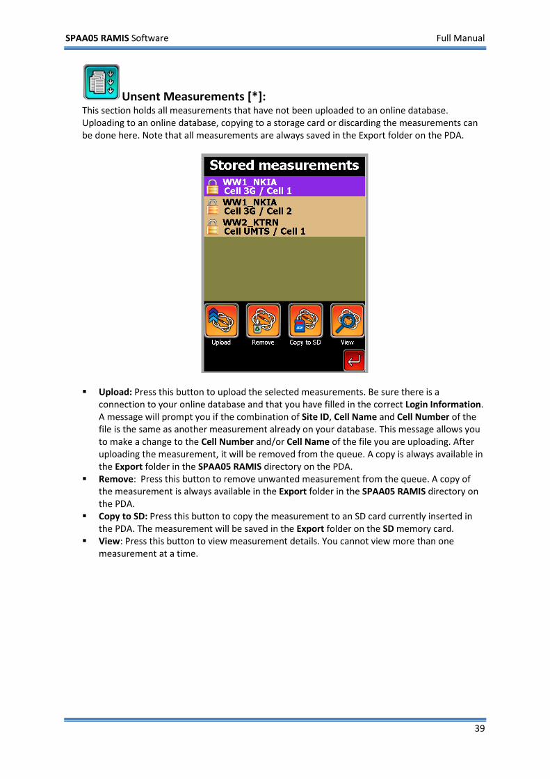
Unsent Measurements [*]: This section holds all measurements that have not been uploaded to an online database. Uploading to an online database, copying to a storage card or discarding the measurements can be done here. Note that all measurements are always saved in the Export folder on the PDA.
Upload: Press this button to upload the selected measurements. Be sure there is a
connection to your online database and that you have filled in the correct Login Information. A message will prompt you if the combination of Site ID, Cell Name and Cell Number of the file is the same as another measurement already on your database. This message allows you to make a change to the Cell Number and/or Cell Name of the file you are uploading. After uploading the measurement, it will be removed from the queue. A copy is always available in the Export folder in the SPAA05 RAMIS directory on the PDA.
Remove: Press this button to remove unwanted measurement from the queue. A copy of the measurement is always available in the Export folder in the SPAA05 RAMIS directory on the PDA.
Copy to SD: Press this button to copy the measurement to an SD card currently inserted in the PDA. The measurement will be saved in the Export folder on the SD memory card.
View: Press this button to view measurement details. You cannot view more than one measurement at a time.
SPAA05 RAMIS Software Full Manual
40
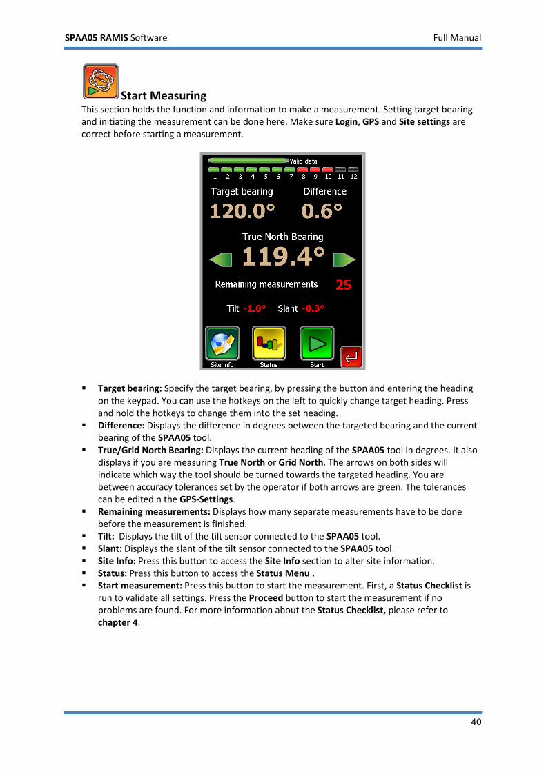
Start Measuring This section holds the function and information to make a measurement. Setting target bearing and initiating the measurement can be done here. Make sure Login, GPS and Site settings are correct before starting a measurement.
Target bearing: Specify the target bearing, by pressing the button and entering the heading
on the keypad. You can use the hotkeys on the left to quickly change target heading. Press and hold the hotkeys to change them into the set heading.
Difference: Displays the difference in degrees between the targeted bearing and the current bearing of the SPAA05 tool.
True/Grid North Bearing: Displays the current heading of the SPAA05 tool in degrees. It also displays if you are measuring True North or Grid North. The arrows on both sides will indicate which way the tool should be turned towards the targeted heading. You are between accuracy tolerances set by the operator if both arrows are green. The tolerances can be edited n the GPS-Settings.
Remaining measurements: Displays how many separate measurements have to be done before the measurement is finished.
Tilt: Displays the tilt of the tilt sensor connected to the SPAA05 tool. Slant: Displays the slant of the tilt sensor connected to the SPAA05 tool. Site Info: Press this button to access the Site Info section to alter site information. Status: Press this button to access the Status Menu . Start measurement: Press this button to start the measurement. First, a Status Checklist is
run to validate all settings. Press the Proceed button to start the measurement if no problems are found. For more information about the Status Checklist, please refer to chapter 4.
SPAA05 RAMIS Software Full Manual
41
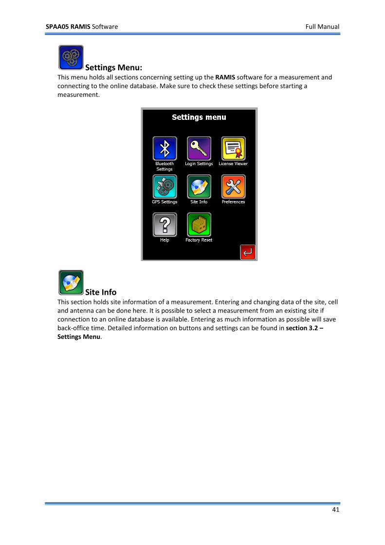
Settings Menu: This menu holds all sections concerning setting up the RAMIS software for a measurement and connecting to the online database. Make sure to check these settings before starting a measurement.
Site Info This section holds site information of a measurement. Entering and changing data of the site, cell and antenna can be done here. It is possible to select a measurement from an existing site if connection to an online database is available. Entering as much information as possible will save back-office time. Detailed information on buttons and settings can be found in section 3.2 – Settings Menu.
SPAA05 RAMIS Software Full Manual
42
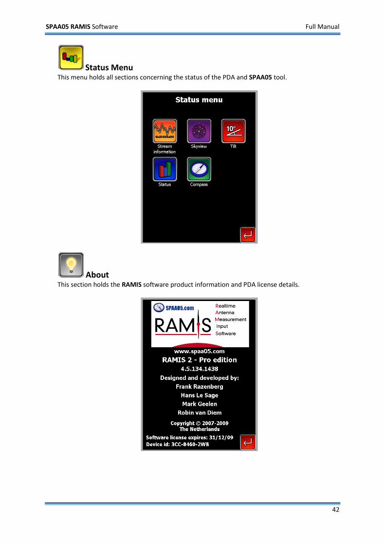
Status Menu This menu holds all sections concerning the status of the PDA and SPAA05 tool.
About This section holds the RAMIS software product information and PDA license details.
SPAA05 RAMIS Software Full Manual
43
3.2 Settings Menu
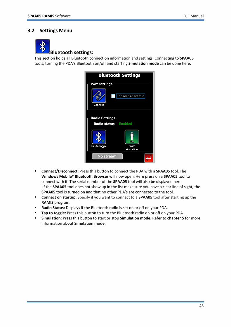
Bluetooth settings: This section holds all Bluetooth connection information and settings. Connecting to SPAA05 tools, turning the PDA’s Bluetooth on/off and starting Simulation mode can be done here.
Connect/Disconnect: Press this button to connect the PDA with a SPAA05 tool. The
Windows Mobile® Bluetooth Browser will now open. Here press on a SPAA05 tool to connect with it. The serial number of the SPAA05 tool will also be displayed here. If the SPAA05 tool does not show up in the list make sure you have a clear line of sight, the SPAA05 tool is turned on and that no other PDA’s are connected to the tool.
Connect on startup: Specify if you want to connect to a SPAA05 tool after starting up the RAMIS program.
Radio Status: Displays if the Bluetooth radio is set on or off on your PDA. Tap to toggle: Press this button to turn the Bluetooth radio on or off on your PDA Simulation: Press this button to start or stop Simulation mode. Refer to chapter 5 for more
information about Simulation mode.
SPAA05 RAMIS Software Full Manual
44
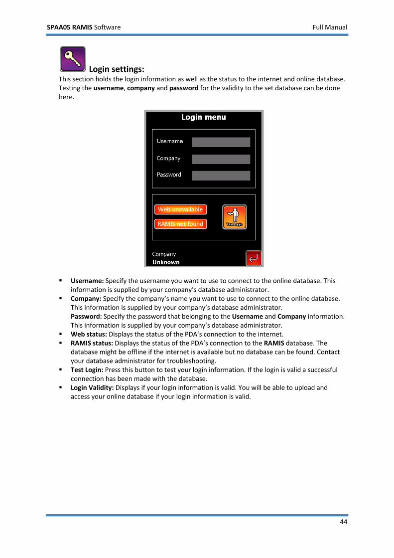
Login settings: This section holds the login information as well as the status to the internet and online database. Testing the username, company and password for the validity to the set database can be done here.
Username: Specify the username you want to use to connect to the online database. This
information is supplied by your company’s database administrator. Company: Specify the company’s name you want to use to connect to the online database.
This information is supplied by your company’s database administrator. Password: Specify the password that belonging to the Username and Company information. This information is supplied by your company’s database administrator.
Web status: Displays the status of the PDA’s connection to the internet. RAMIS status: Displays the status of the PDA’s connection to the RAMIS database. The
database might be offline if the internet is available but no database can be found. Contact your database administrator for troubleshooting.
Test Login: Press this button to test your login information. If the login is valid a successful connection has been made with the database.
Login Validity: Displays if your login information is valid. You will be able to upload and access your online database if your login information is valid.
SPAA05 RAMIS Software Full Manual
45
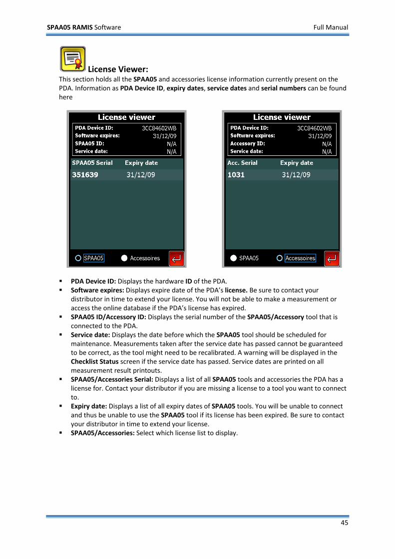
License Viewer: This section holds all the SPAA05 and accessories license information currently present on the PDA. Information as PDA Device ID, expiry dates, service dates and serial numbers can be found here
PDA Device ID: Displays the hardware ID of the PDA. Software expires: Displays expire date of the PDA’s license. Be sure to contact your
distributor in time to extend your license. You will not be able to make a measurement or access the online database if the PDA’s license has expired.
SPAA05 ID/Accessory ID: Displays the serial number of the SPAA05/Accessory tool that is connected to the PDA.
Service date: Displays the date before which the SPAA05 tool should be scheduled for maintenance. Measurements taken after the service date has passed cannot be guaranteed to be correct, as the tool might need to be recalibrated. A warning will be displayed in the Checklist Status screen if the service date has passed. Service dates are printed on all measurement result printouts.
SPAA05/Accessories Serial: Displays a list of all SPAA05 tools and accessories the PDA has a license for. Contact your distributor if you are missing a license to a tool you want to connect to.
Expiry date: Displays a list of all expiry dates of SPAA05 tools. You will be unable to connect and thus be unable to use the SPAA05 tool if its license has been expired. Be sure to contact your distributor in time to extend your license.
SPAA05/Accessories: Select which license list to display.
SPAA05 RAMIS Software Full Manual
46
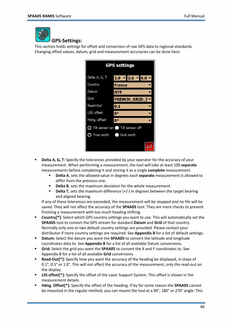
GPS-Settings: This section holds settings for offset and conversion of raw GPS data to regional standards. Changing offset values, datum, grid and measurement accuracies can be done here.
Delta A, G, T: Specify the tolerances provided by your operator for the accuracy of your
measurement. When performing a measurement, the tool will take at least 100 separate measurements before completing it and storing it as a single complete measurement. Delta A, sets the allowed value in degrees each separate measurement is allowed to
differ from the previous one. Delta B, sets the maximum deviation for the whole measurement. Delta T, sets the maximum difference (+/-) in degrees between the target bearing
and aligned bearing. If any of these tolerances are exceeded, the measurement will be stopped and no file will be saved. They will not affect the accuracy of the SPAA05 tool. They are mere checks to prevent finishing a measurement with too much heading shifting.
Country[*]: Select which GPS country settings you want to use. This will automatically set the SPAA05 tool to convert the GPS stream for standard Datum and Grid of that country. Normally only one or two default country settings are provided. Please contact your distributor if more country settings are required. See Appendix B for a list of default settings.
Datum: Select the datum you want the SPAA05 to convert the latitude and longitude coordinates data to. See Appendix B for a list of all available Datum conversions.
Grid: Select the grid you want the SPAA05 to convert the X and Y coordinates to. See Appendix B for a list of all available Grid conversions.
Read-Out[*]: Specify how you want the accuracy of the heading be displayed, in steps of 0.1°, 0.5° or 1.0°. This will not affect the accuracy of the measurement, only the read-out on the display.
LSS offset[*]: Specify the offset of the Laser Support System. This offset is shown in the measurement details.
Hdng. Offset[*]: Specify the offset of the heading. If by for some reason the SPAA05 cannot be mounted in the regular method, you can mount the tool at a 90°, 180° or 270° angle. This
SPAA05 RAMIS Software Full Manual
47
way you can measure as if you would normally with a regular mounted tool. The offset is defined clockwise. This offset is shown in the measurement details.
Tilt sensor on/off: Select the power status of the connected tilt sensor. True/Grid North[*]: Select the north bearing type that the SPAA05 will convert data to. The
bearing type is shown in the measurement details.
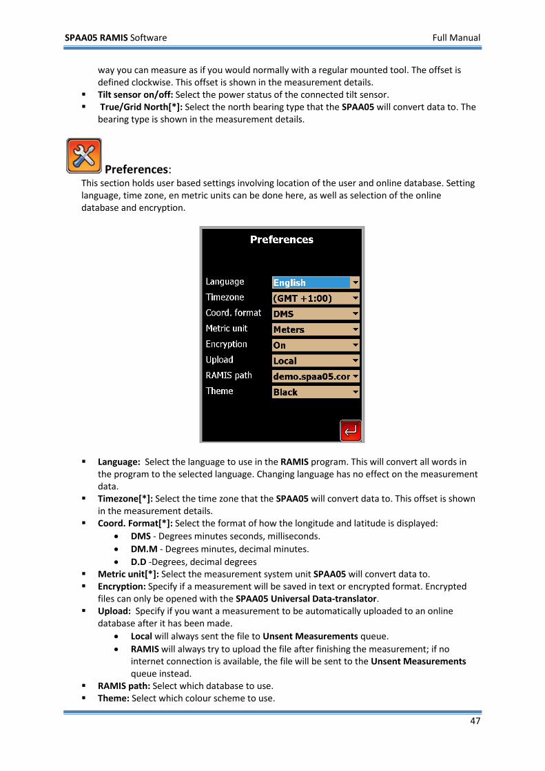
Preferences: This section holds user based settings involving location of the user and online database. Setting language, time zone, en metric units can be done here, as well as selection of the online database and encryption.
Language: Select the language to use in the RAMIS program. This will convert all words in
the program to the selected language. Changing language has no effect on the measurement data.
Timezone[*]: Select the time zone that the SPAA05 will convert data to. This offset is shown in the measurement details.
Coord. Format[*]: Select the format of how the longitude and latitude is displayed: • DMS - Degrees minutes seconds, milliseconds. • DM.M - Degrees minutes, decimal minutes. • D.D -Degrees, decimal degrees
Metric unit[*]: Select the measurement system unit SPAA05 will convert data to. Encryption: Specify if a measurement will be saved in text or encrypted format. Encrypted
files can only be opened with the SPAA05 Universal Data-translator. Upload: Specify if you want a measurement to be automatically uploaded to an online
database after it has been made. • Local will always sent the file to Unsent Measurements queue. • RAMIS will always try to upload the file after finishing the measurement; if no
internet connection is available, the file will be sent to the Unsent Measurements queue instead.
RAMIS path: Select which database to use. Theme: Select which colour scheme to use.
SPAA05 RAMIS Software Full Manual
48
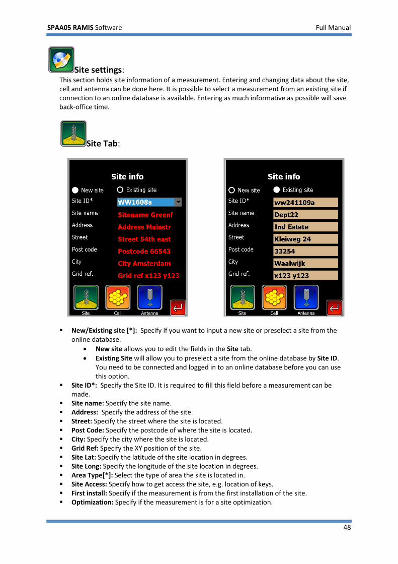
Site settings: This section holds site information of a measurement. Entering and changing data about the site, cell and antenna can be done here. It is possible to select a measurement from an existing site if connection to an online database is available. Entering as much informative as possible will save back-office time.
Site Tab:
New/Existing site [*]: Specify if you want to input a new site or preselect a site from the
online database. • New site allows you to edit the fields in the Site tab. • Existing Site will allow you to preselect a site from the online database by Site ID.
You need to be connected and logged in to an online database before you can use this option.
Site ID*: Specify the Site ID. It is required to fill this field before a measurement can be made.
Site name: Specify the site name. Address: Specify the address of the site. Street: Specify the street where the site is located. Post Code: Specify the postcode of where the site is located. City: Specify the city where the site is located. Grid Ref: Specify the XY position of the site. Site Lat: Specify the latitude of the site location in degrees. Site Long: Specify the longitude of the site location in degrees. Area Type[*]: Select the type of area the site is located in. Site Access: Specify how to get access the site, e.g. location of keys. First install: Specify if the measurement is from the first installation of the site. Optimization: Specify if the measurement is for a site optimization.
SPAA05 RAMIS Software Full Manual
49
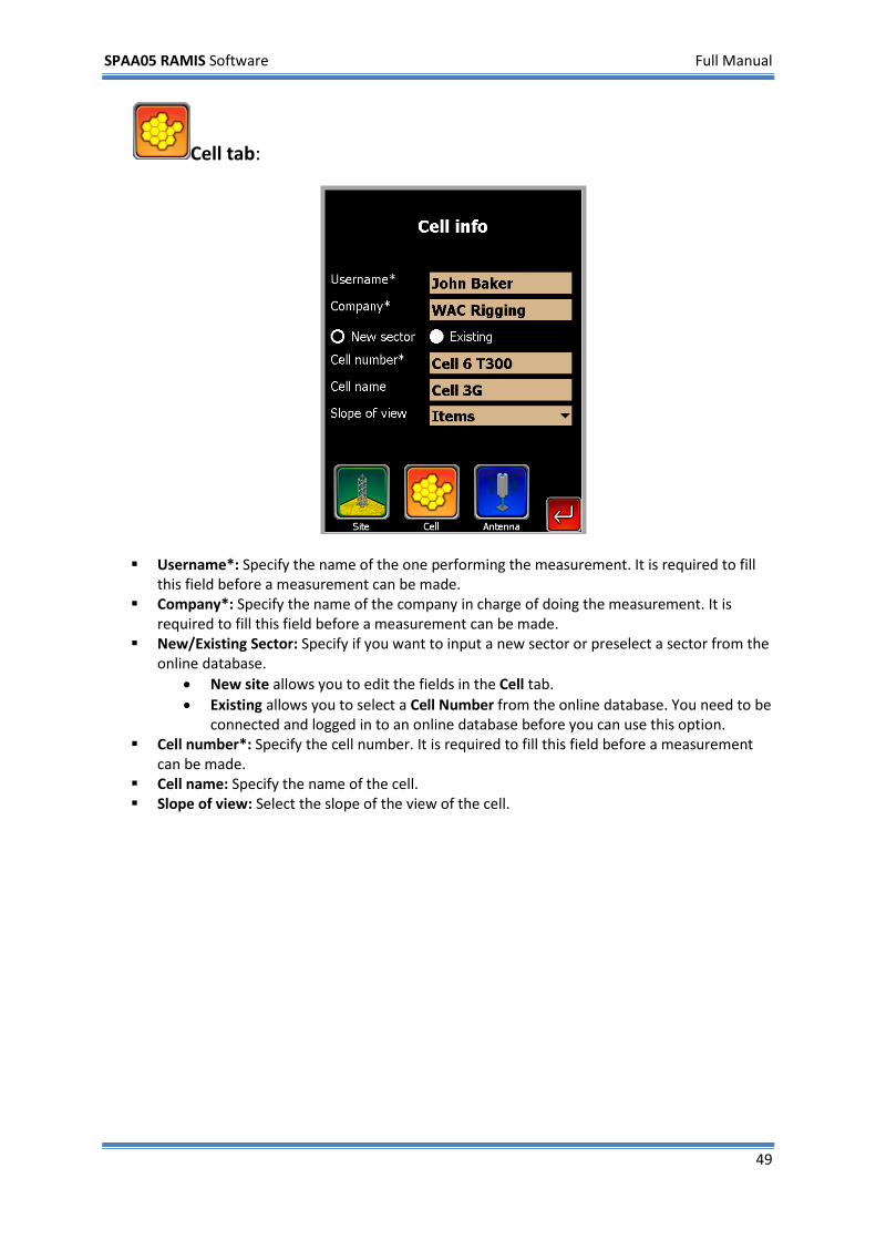
Cell tab:
Username*: Specify the name of the one performing the measurement. It is required to fill
this field before a measurement can be made. Company*: Specify the name of the company in charge of doing the measurement. It is
required to fill this field before a measurement can be made. New/Existing Sector: Specify if you want to input a new sector or preselect a sector from the
online database. • New site allows you to edit the fields in the Cell tab. • Existing allows you to select a Cell Number from the online database. You need to be
connected and logged in to an online database before you can use this option. Cell number*: Specify the cell number. It is required to fill this field before a measurement
can be made. Cell name: Specify the name of the cell. Slope of view: Select the slope of the view of the cell.
SPAA05 RAMIS Software Full Manual
50
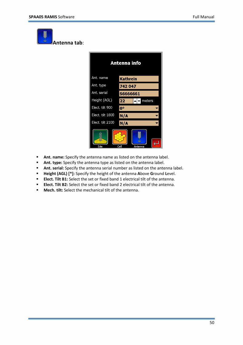
Antenna tab:
Ant. name: Specify the antenna name as listed on the antenna label. Ant. type: Specify the antenna type as listed on the antenna label. Ant. serial: Specify the antenna serial number as listed on the antenna label. Height (AGL) [*]: Specify the height of the antenna Above Ground Level. Elect. Tilt B1: Select the set or fixed band 1 electrical tilt of the antenna. Elect. Tilt B2: Select the set or fixed band 2 electrical tilt of the antenna. Mech. tilt: Select the mechanical tilt of the antenna.
SPAA05 RAMIS Software Full Manual
51
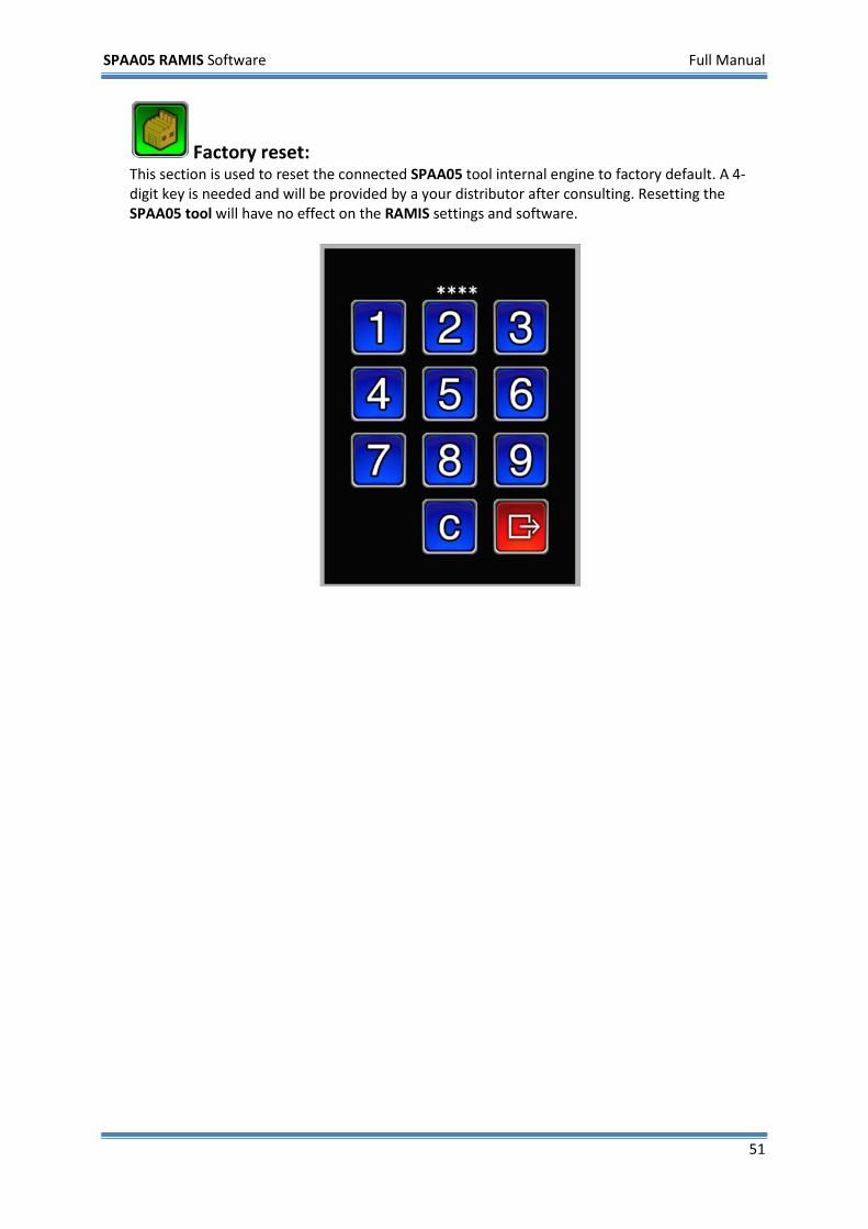
Factory reset: This section is used to reset the connected SPAA05 tool internal engine to factory default. A 4-digit key is needed and will be provided by a your distributor after consulting. Resetting the SPAA05 tool will have no effect on the RAMIS settings and software.
SPAA05 RAMIS Software Full Manual
52
3.3 Status menu
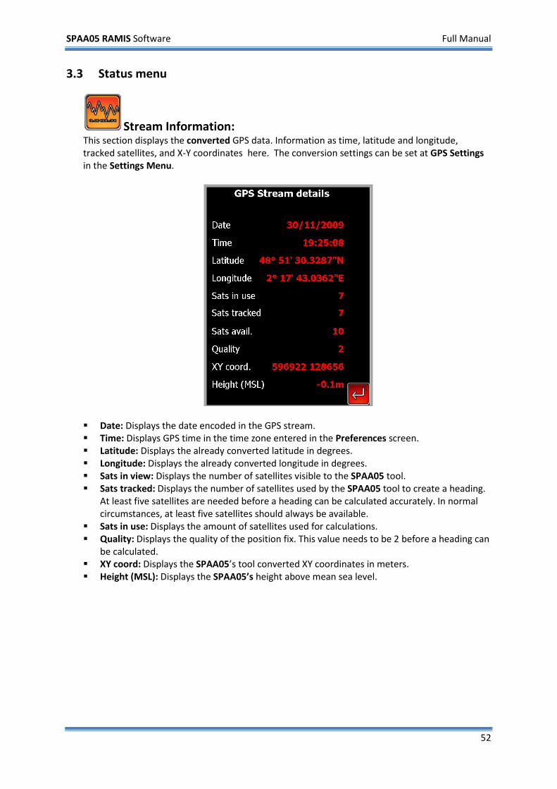
Stream Information: This section displays the converted GPS data. Information as time, latitude and longitude, tracked satellites, and X-Y coordinates here. The conversion settings can be set at GPS Settings in the Settings Menu.
Date: Displays the date encoded in the GPS stream. Time: Displays GPS time in the time zone entered in the Preferences screen. Latitude: Displays the already converted latitude in degrees. Longitude: Displays the already converted longitude in degrees. Sats in view: Displays the number of satellites visible to the SPAA05 tool. Sats tracked: Displays the number of satellites used by the SPAA05 tool to create a heading.
At least five satellites are needed before a heading can be calculated accurately. In normal circumstances, at least five satellites should always be available.
Sats in use: Displays the amount of satellites used for calculations. Quality: Displays the quality of the position fix. This value needs to be 2 before a heading can
be calculated. XY coord: Displays the SPAA05’s tool converted XY coordinates in meters. Height (MSL): Displays the SPAA05’s height above mean sea level.
SPAA05 RAMIS Software Full Manual
53
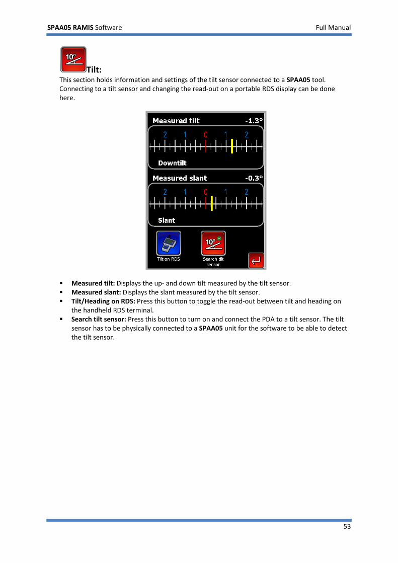
Tilt: This section holds information and settings of the tilt sensor connected to a SPAA05 tool. Connecting to a tilt sensor and changing the read-out on a portable RDS display can be done here.
Measured tilt: Displays the up- and down tilt measured by the tilt sensor. Measured slant: Displays the slant measured by the tilt sensor. Tilt/Heading on RDS: Press this button to toggle the read-out between tilt and heading on
the handheld RDS terminal. Search tilt sensor: Press this button to turn on and connect the PDA to a tilt sensor. The tilt
sensor has to be physically connected to a SPAA05 unit for the software to be able to detect the tilt sensor.
SPAA05 RAMIS Software Full Manual
54
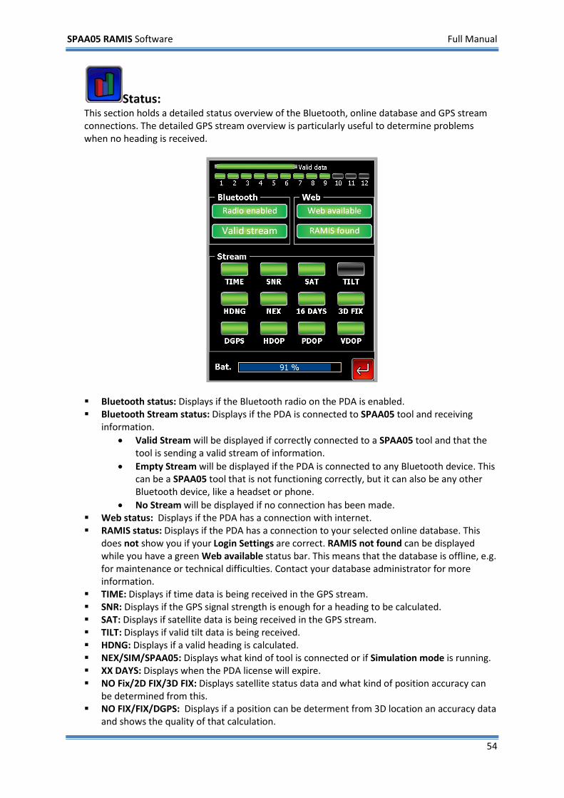
Status: This section holds a detailed status overview of the Bluetooth, online database and GPS stream connections. The detailed GPS stream overview is particularly useful to determine problems when no heading is received.
Bluetooth status: Displays if the Bluetooth radio on the PDA is enabled. Bluetooth Stream status: Displays if the PDA is connected to SPAA05 tool and receiving
information. • Valid Stream will be displayed if correctly connected to a SPAA05 tool and that the
tool is sending a valid stream of information. • Empty Stream will be displayed if the PDA is connected to any Bluetooth device. This
can be a SPAA05 tool that is not functioning correctly, but it can also be any other Bluetooth device, like a headset or phone.
• No Stream will be displayed if no connection has been made. Web status: Displays if the PDA has a connection with internet. RAMIS status: Displays if the PDA has a connection to your selected online database. This
does not show you if your Login Settings are correct. RAMIS not found can be displayed while you have a green Web available status bar. This means that the database is offline, e.g. for maintenance or technical difficulties. Contact your database administrator for more information.
TIME: Displays if time data is being received in the GPS stream. SNR: Displays if the GPS signal strength is enough for a heading to be calculated. SAT: Displays if satellite data is being received in the GPS stream. TILT: Displays if valid tilt data is being received. HDNG: Displays if a valid heading is calculated. NEX/SIM/SPAA05: Displays what kind of tool is connected or if Simulation mode is running. XX DAYS: Displays when the PDA license will expire. NO Fix/2D FIX/3D FIX: Displays satellite status data and what kind of position accuracy can
be determined from this. NO FIX/FIX/DGPS: Displays if a position can be determent from 3D location an accuracy data
and shows the quality of that calculation.
SPAA05 RAMIS Software Full Manual
55
HOR: Displays quality of the horizontal dilution of position. POS: Displays quality of the dilution of position. VERT: Displays quality of the vertical dilution of position. BAT: Displays the battery charge of the PDA internal battery.
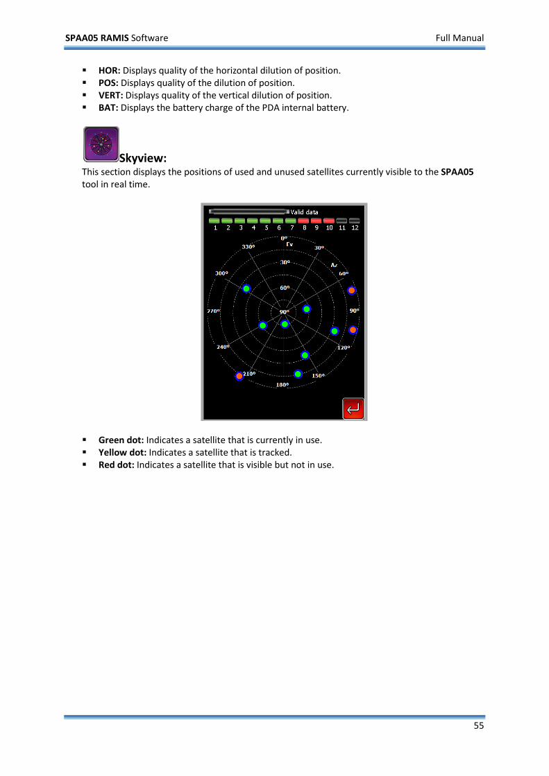
Skyview: This section displays the positions of used and unused satellites currently visible to the SPAA05 tool in real time.
Green dot: Indicates a satellite that is currently in use. Yellow dot: Indicates a satellite that is tracked. Red dot: Indicates a satellite that is visible but not in use.
SPAA05 RAMIS Software Full Manual
56
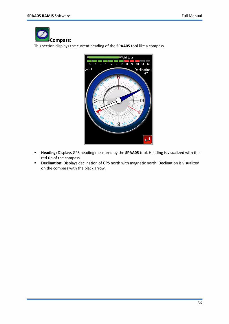
Compass: This section displays the current heading of the SPAA05 tool like a compass.
Heading: Displays GPS heading measured by the SPAA05 tool. Heading is visualized with the red tip of the compass.
Declination: Displays declination of GPS north with magnetic north. Declination is visualized on the compass with the black arrow.
SPAA05 RAMIS Software Full Manual
57
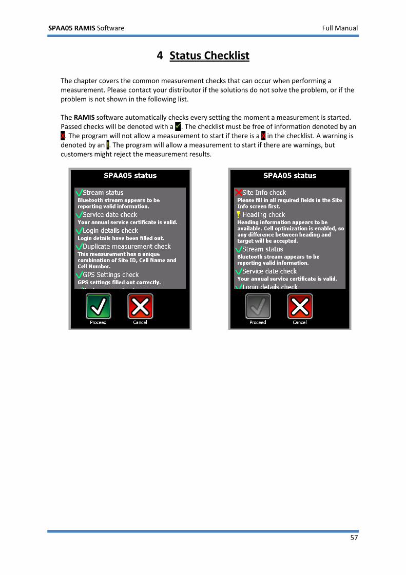
4 Status Checklist The chapter covers the common measurement checks that can occur when performing a measurement. Please contact your distributor if the solutions do not solve the problem, or if the problem is not shown in the following list. The RAMIS software automatically checks every setting the moment a measurement is started. Passed checks will be denoted with a . The checklist must be free of information denoted by an X. The program will not allow a measurement to start if there is a X in the checklist. A warning is denoted by an !. The program will allow a measurement to start if there are warnings, but customers might reject the measurement results.
SPAA05 RAMIS Software Full Manual
58
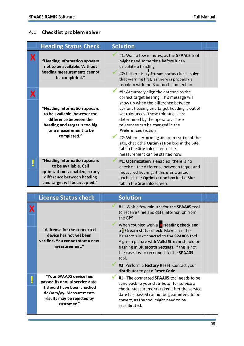
4.1 Checklist problem solver Heading Status Check Solution
X “Heading information appears not to be available. Without
heading measurements cannot be completed.”
#1: Wait a few minutes, as the SPAA05 tool might need some time before it can calculate a heading.
#2: If there is a ! Stream status check; solve that warning first, as there is probably a problem with the Bluetooth connection.
X ”Heading information appears to be available; however the
difference between the heading and target is too big
for a measurement to be completed.”
#1: Accurately align the antenna to the correct target bearing. This message will show up when the difference between current heading and target heading is out of set tolerances. These tolerances are determined by the operator, These tolerances can be changed in the Preferences section
#2: When performing an optimization of the site, check the Optimization box in the Site tab in the Site Info screen. The measurement can be started now.
! “Heading information appears to be available. Cell
optimization is enabled, so any difference between heading and target will be accepted.”
#1: Optimization is enabled, there is no check on the difference between target and measured bearing, if this is unwanted, uncheck the Optimization box in the Site tab in the Site Info screen.
License Status check Solution
X
"A license for the connected device has not yet been
verified. You cannot start a new measurement."
#1: Wait a few minutes for the SPAA05 tool to receive time and date information from the GPS.
When coupled with a X Heading check and a ! Stream status check. Make sure the Bluetooth is connected to the SPAA05 tool. A green picture with Valid Stream should be flashing in Bluetooth Settings. If this is not the case, try to reconnect to the SPAA05 tool.
#3: Perform a Factory Reset. Contact your distributor to get a Reset Code.
! “Your SPAA05 device has passed its annual service date. It should have been checked dd/mm/yy. Measurements results may be rejected by
customer.”
#1: The connected SPAA05 tool needs to be send back to your distributor for service a check. Measurements taken after the service date has passed cannot be guaranteed to be correct, as the tool might need to be recalibrated.
SPAA05 RAMIS Software Full Manual
59
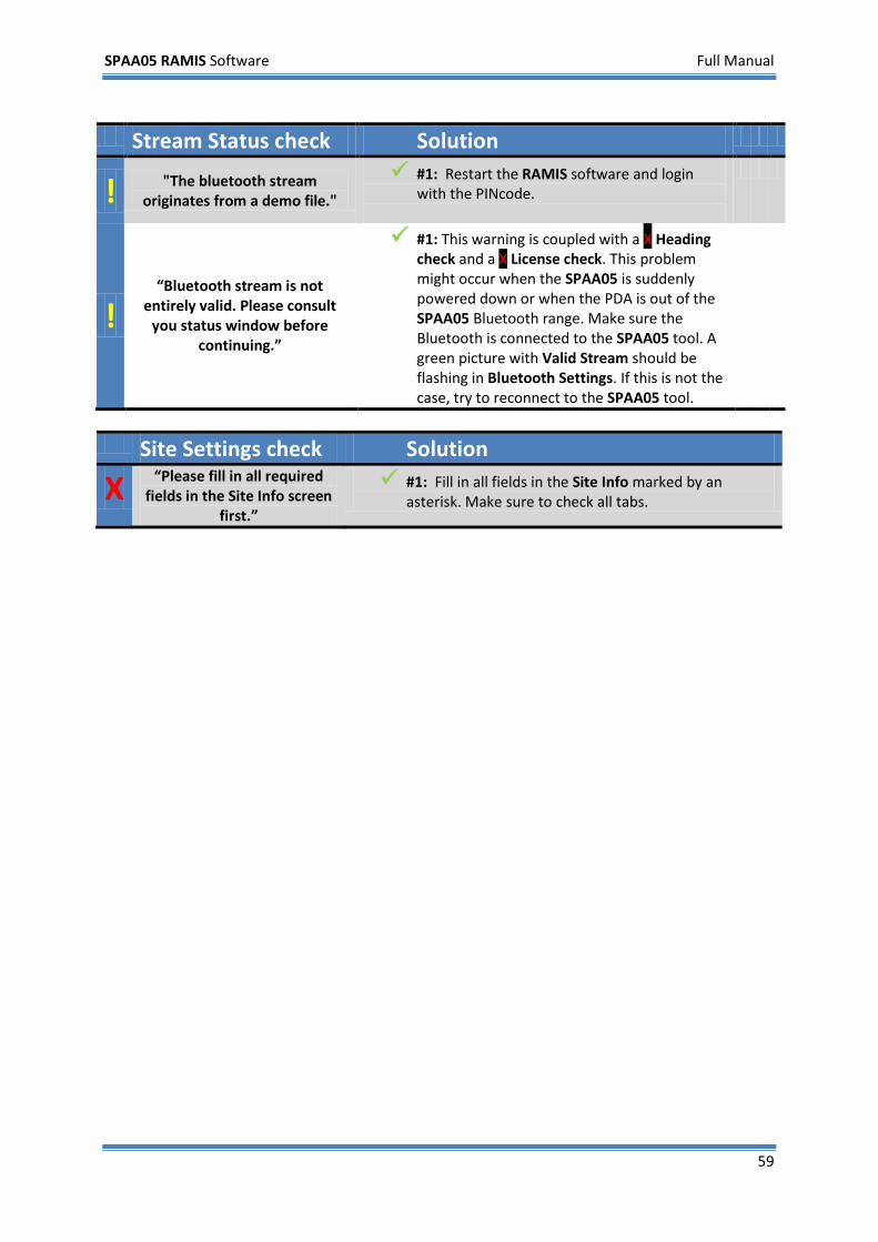
Stream Status check Solution
! "The bluetooth stream originates from a demo file."
#1: Restart the RAMIS software and login with the PINcode.
! “Bluetooth stream is not
entirely valid. Please consult you status window before
continuing.”
#1: This warning is coupled with a X Heading check and a X License check. This problem might occur when the SPAA05 is suddenly powered down or when the PDA is out of the SPAA05 Bluetooth range. Make sure the Bluetooth is connected to the SPAA05 tool. A green picture with Valid Stream should be flashing in Bluetooth Settings. If this is not the case, try to reconnect to the SPAA05 tool.
Site Settings check Solution
X “Please fill in all required fields in the Site Info screen
first.”
#1: Fill in all fields in the Site Info marked by an asterisk. Make sure to check all tabs.
SPAA05 RAMIS Software Full Manual
60
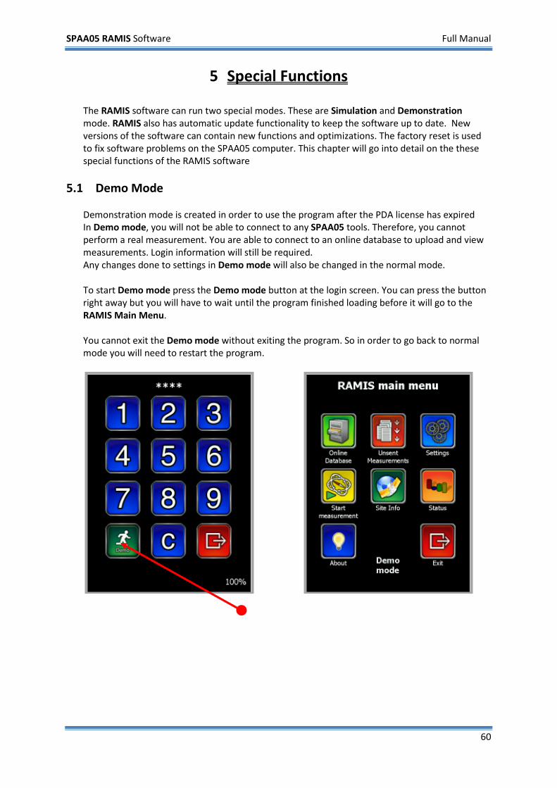
5 Special Functions The RAMIS software can run two special modes. These are Simulation and Demonstration mode. RAMIS also has automatic update functionality to keep the software up to date. New versions of the software can contain new functions and optimizations. The factory reset is used to fix software problems on the SPAA05 computer. This chapter will go into detail on the these special functions of the RAMIS software
5.1 Demo Mode Demonstration mode is created in order to use the program after the PDA license has expired In Demo mode, you will not be able to connect to any SPAA05 tools. Therefore, you cannot perform a real measurement. You are able to connect to an online database to upload and view measurements. Login information will still be required. Any changes done to settings in Demo mode will also be changed in the normal mode. To start Demo mode press the Demo mode button at the login screen. You can press the button right away but you will have to wait until the program finished loading before it will go to the RAMIS Main Menu. You cannot exit the Demo mode without exiting the program. So in order to go back to normal mode you will need to restart the program.
SPAA05 RAMIS Software Full Manual
61
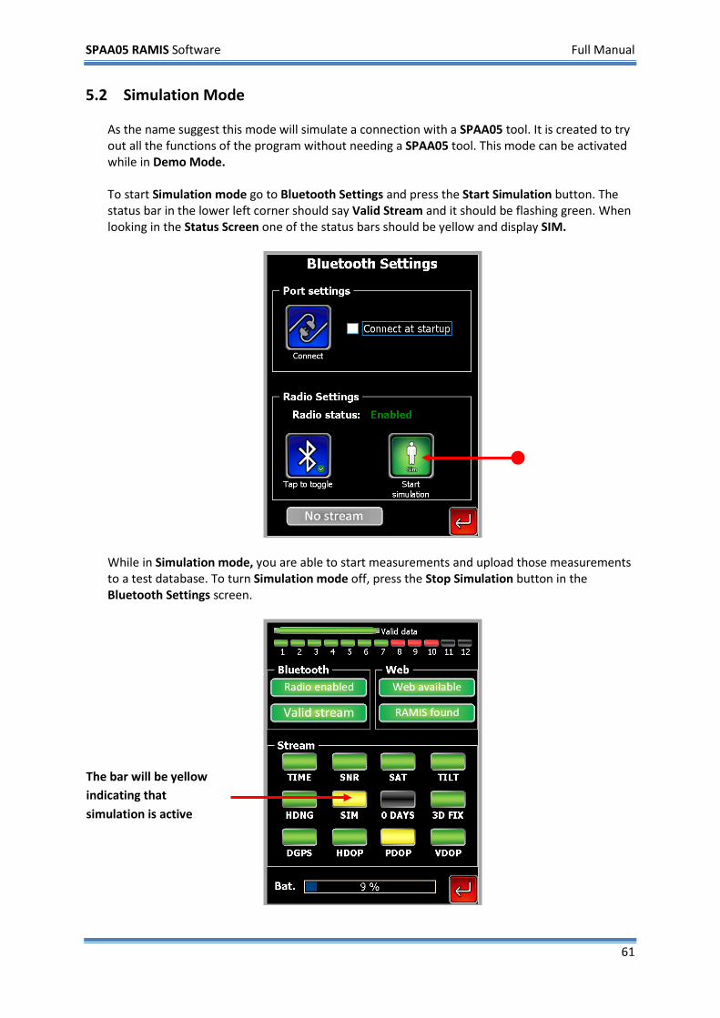
5.2 Simulation Mode As the name suggest this mode will simulate a connection with a SPAA05 tool. It is created to try out all the functions of the program without needing a SPAA05 tool. This mode can be activated while in Demo Mode. To start Simulation mode go to Bluetooth Settings and press the Start Simulation button. The status bar in the lower left corner should say Valid Stream and it should be flashing green. When looking in the Status Screen one of the status bars should be yellow and display SIM.
While in Simulation mode, you are able to start measurements and upload those measurements to a test database. To turn Simulation mode off, press the Stop Simulation button in the Bluetooth Settings screen.
The bar will be yellow indicating that simulation is active
SPAA05 RAMIS Software Full Manual
62
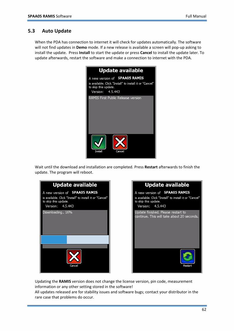
5.3 Auto Update When the PDA has connection to internet it will check for updates automatically. The software will not find updates in Demo mode. If a new release is available a screen will pop-up asking to install the update. Press Install to start the update or press Cancel to install the update later. To update afterwards, restart the software and make a connection to internet with the PDA.
Wait until the download and installation are completed. Press Restart afterwards to finish the update. The program will reboot.
Updating the RAMIS version does not change the license version, pin code, measurement information or any other setting stored in the software! All updates released are for stability issues and software bugs; contact your distributor in the rare case that problems do occur.
SPAA05 RAMIS Software Full Manual
63
Troubleshooting
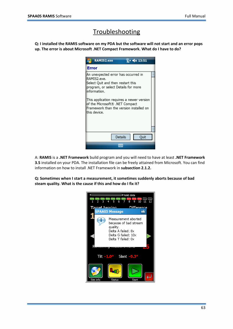
Q: I installed the RAMIS software on my PDA but the software will not start and an error pops up. The error is about Microsoft .NET Compact Framework. What do I have to do?
A: RAMIS is a .NET Framework build program and you will need to have at least .NET Framework 3.5 installed on your PDA. The installation file can be freely attained from Microsoft. You can find information on how to install .NET Framework in subsection 2.1.2. Q: Sometimes when I start a measurement, it sometimes suddenly aborts because of bad steam quality. What is the cause if this and how do I fix it?

SPAA05 RAMIS Software Full Manual
64
A: The SPAA05 tool is probably moving to much during the measurement and exceeding certain tolerance thresholds . This can happen due to strong wind, or quick last second adjustments to the clamp. First try to fasten the tool as best as possible. If that doesn’t work you can try increasing the tolerance values in the GPS Settings. If the problem still occurs, it’s best to come back for measuring when there is less wind, as we then cannot guarantee a correct accuracy. Refer to section 3.2 - GPS settings - for more information on the Delta A, G and T values. Q: My PDA shows 127.8 as bearing whatever I do, it is not recording any movement. A: Your are probably running in Simulation mode. Go to the Bluetooth Settings screen and press on Stop simulation.
SPAA05 RAMIS Software Full Manual
65
Appendix A SPAA05-NEX Technical specifications GPS Receiver 24 channel DIFF/DGPS GPS receiver with WAAS
Accuracy Heading: 0.5° rms Position: 0.6m rms Altitude/Height: 2.0m msl
Power Battery: NiMh 8.4V 2700mAh Battery life: 8 hrs Charge time: 4 hrs
Mechanics Dimensions: length 0.90m / 1.80m* width 0.13m height 0.07m Weight: 2.30kg** Indicators: Power, heading, differential, on-board, receiver 1 and 2
Communications 9p comport on 38400 baud UART Bluetooth™ internal long range class 1 RDS 1/2/3 comport Remote tiltsensor port (proprietary)
Environmental Operating temperature: -10°C to 50°C (14°F to 122°F) Storage temperatur: -40°C to 85°C (40°F to 185°F) Humidity: 95% non-condensing
System output data*** Site information (Name, location, ect.), cell/sector ID, bearing, True/Grid North, measured
and difference), date/time, longitude/latitude, antenna hardware information, SPAA05 hardware and software information
Parts AB-ST2 integrated telescopic boom with 2 GPS antennas and GPS system AC-E1 universal antenna bracket OOD-K1 keycord with on/off dongle Safety lanyard (3m) 12/110/220V charger with exchangeable EU/UK/USA plugs
* contracted / extended
** 3.10kg with AC-E1 clamp *** among other
SPAA05 RAMIS Software Full Manual
66
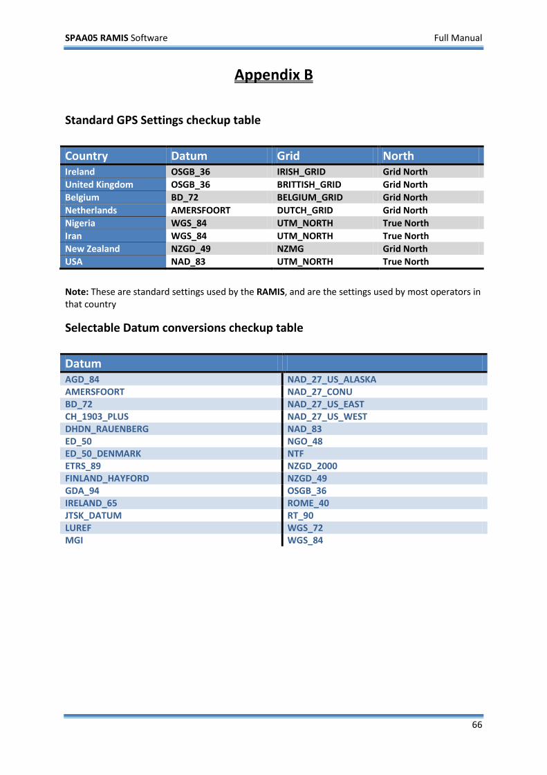
Appendix B
Standard GPS Settings checkup table Country Datum Grid North Ireland OSGB_36 IRISH_GRID Grid North United Kingdom OSGB_36 BRITTISH_GRID Grid North Belgium BD_72 BELGIUM_GRID Grid North Netherlands AMERSFOORT DUTCH_GRID Grid North Nigeria WGS_84 UTM_NORTH True North Iran WGS_84 UTM_NORTH True North New Zealand NZGD_49 NZMG Grid North USA NAD_83 UTM_NORTH True North
Note: These are standard settings used by the RAMIS, and are the settings used by most operators in that country
Selectable Datum conversions checkup table Datum AGD_84 NAD_27_US_ALASKA AMERSFOORT NAD_27_CONU BD_72 NAD_27_US_EAST CH_1903_PLUS NAD_27_US_WEST DHDN_RAUENBERG NAD_83 ED_50 NGO_48 ED_50_DENMARK NTF ETRS_89 NZGD_2000 FINLAND_HAYFORD NZGD_49 GDA_94 OSGB_36 IRELAND_65 ROME_40 JTSK_DATUM RT_90 LUREF WGS_72 MGI WGS_84
SPAA05 RAMIS Software Full Manual
67
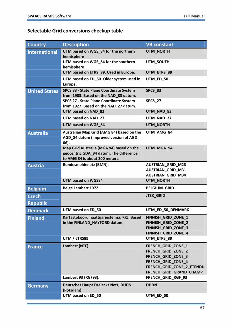
Selectable Grid conversions checkup table
Country Description VB constant International UTM based on WGS_84 for the northern
hemisphere UTM_NORTH
UTM based on WGS_84 for the southern hemisphere
UTM_SOUTH
UTM based on ETRS_89. Used in Europe. UTM_ETRS_89
UTM based on ED_50. Older system used in Europe.
UTM_ED_50
United States SPCS 83 - State Plane Coordinate System from 1983. Based on the NAD_83 datum.
SPCS_83
SPCS 27 - State Plane Coordinate System from 1927. Based on the NAD_27 datum.
SPCS_27
UTM based on NAD_83 UTM_NAD_83
UTM based on NAD_27 UTM_NAD_27
UTM based on WGS_84 UTM_NORTH
Australia Australian Map Grid (AMG 84) based on the AGD_84 datum (improved version of AGD 66).
UTM_AMG_84
Map Grid Australia (MGA 94) based on the geocentric GDA_94 datum. The difference to AMG 84 is about 200 meters.
UTM_MGA_94
Austria Bundesmeldenetz (BMN). AUSTRIAN_GRID_M28 AUSTRIAN_GRID_M31 AUSTRIAN_GRID_M34
UTM based on WGS84 UTM_NORTH
Belgium Belge Lambert 1972. BELGIUM_GRID
Czech Republic
JTSK_GRID
Denmark UTM based on ED_50 UTM_ED_50_DENMARK
Finland Kartastokoordinaattijärjestelmä, KKJ. Based in the FINLAND_HAYFORD datum.
FINNISH_GRID_ZONE_1 FINNISH_GRID_ZONE_2 FINNISH_GRID_ZONE_3 FINNISH_GRID_ZONE_4
UTM / ETRS89 UTM_ETRS_89
France Lambert (NTF). FRENCH_GRID_ZONE_1 FRENCH_GRID_ZONE_2 FRENCH_GRID_ZONE_3 FRENCH_GRID_ZONE_4 FRENCH_GRID_ZONE_2_ETENDU FRENCH_GRID_GRAND_CHAMP
Lambert 93 (RGF93). FRENCH_GRID_RGF_93
Germany Deutsches Haupt Dreiecks Netz, DHDN (Potsdam)
DHDN
UTM based on ED_50 UTM_ED_50
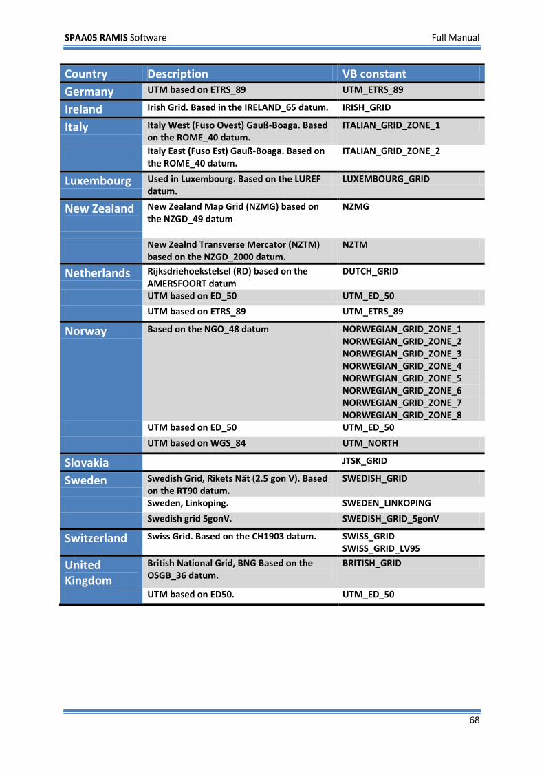
SPAA05 RAMIS Software Full Manual
68
Country Description VB constant Germany UTM based on ETRS_89 UTM_ETRS_89
Ireland Irish Grid. Based in the IRELAND_65 datum. IRISH_GRID
Italy Italy West (Fuso Ovest) Gauß-Boaga. Based on the ROME_40 datum.
ITALIAN_GRID_ZONE_1
Italy East (Fuso Est) Gauß-Boaga. Based on the ROME_40 datum.
ITALIAN_GRID_ZONE_2
Luxembourg Used in Luxembourg. Based on the LUREF datum.
LUXEMBOURG_GRID
New Zealand
New Zealand Map Grid (NZMG) based on the NZGD_49 datum
NZMG
New Zealnd Transverse Mercator (NZTM) based on the NZGD_2000 datum.
NZTM
Netherlands Rijksdriehoekstelsel (RD) based on the AMERSFOORT datum
DUTCH_GRID
UTM based on ED_50 UTM_ED_50
UTM based on ETRS_89 UTM_ETRS_89
Norway Based on the NGO_48 datum NORWEGIAN_GRID_ZONE_1 NORWEGIAN_GRID_ZONE_2 NORWEGIAN_GRID_ZONE_3 NORWEGIAN_GRID_ZONE_4 NORWEGIAN_GRID_ZONE_5 NORWEGIAN_GRID_ZONE_6 NORWEGIAN_GRID_ZONE_7 NORWEGIAN_GRID_ZONE_8
UTM based on ED_50 UTM_ED_50
UTM based on WGS_84 UTM_NORTH
Slovakia JTSK_GRID
Sweden Swedish Grid, Rikets Nät (2.5 gon V). Based on the RT90 datum.
SWEDISH_GRID
Sweden, Linkoping. SWEDEN_LINKOPING
Swedish grid 5gonV. SWEDISH_GRID_5gonV
Switzerland Swiss Grid. Based on the CH1903 datum. SWISS_GRID SWISS_GRID_LV95
United Kingdom
British National Grid, BNG Based on the OSGB_36 datum.
BRITISH_GRID
UTM based on ED50. UTM_ED_50
SPAA05 RAMIS Software Full Manual
69
Credit Notice Copyright Notice
SPAA05.com has prepared this manual for use by SPAA05.com personnel and customers as a guide for the proper installation, operation and maintenance of SPAA05 equipment and computer programs. The drawings, specifications, and information contained herein are the property of SPAA05.com, and any unauthorized use or disclosure of these drawings, specifications, and information is prohibited; they shall not be reproduced, copied, or used in whole or in part as the basis for manufacture or sale of the equipment or software programs without the prior written consent of SPAA05.com.
Trademarks
The SPAA05 logo, the UDT logo, SPAA05®, RAMIS® and RAAM® are trademarks of SPAA05.com. Windows Mobile and Microsoft are either registered trademarks or trademarks of Microsoft Corporation in the United States and/or other countries.
Links SPAA05 Website: http://www.SPAA05.com
SPAA05 Universal Data-translator: http://www.SPAA05.com/udt/
RAMIS online database portal: http://ramis.SPAA05.com
Microsoft Windows ActiveSync: http://www.microsoft.com/windowsmobile
Contact
For a list of resellers and agents of SPAA05.com, please visit our website. Main contact details:
Kleiweg 24, 5145 NB Waalwijk, the Netherlands Telephone: +31 416 565 005 Fax: +31 416 565 006 E-mail: [email protected]

SPAA05 RAMIS Software Full Manual
70
SPAA05 RAMIS Software Full Manual
71
Distributed by:


![Fuentes Agua Superficial Ramis[1]](https://img.pdfslide.net/doc/110x75/54dcbfcb4a7959a8648b4611/fuentes-agua-superficial-ramis1.jpg)