Embed Size (px)
Citation preview

Rare Plant and Vegetation Survey of Seaquest State Park
Pacific Biodiversity InstitutePacific Biodiversity InstitutePacific Biodiversity InstitutePacific Biodiversity Institute

2
3
Rare Plant and Vegetation Survey of Seaquest State Park
Hans M. Smith IV [email protected]
Peter H. Morrison
December 2006
Pacific Biodiversity Institute
P.O. Box 298 Winthrop, Washington 98862
509-996-2490
Recommended Citation Smith, H.M. IV and P.H. Morrison. 2006. Rare Plant and Vegetation Survey of Seaquest State Park. Pacific Biodiversity Institute, Winthrop, Washington. 88 p.
Acknowledgements The photographs in this report are by Hans Smith. Juliet Rhodes completed the data entry and worked on checking data integrity. LeChi Huynh, a conservation science intern at Pacific Biodiversity Institute, edited the report.
Project Funding This project was conducted under a contract with the Washington State Parks and Recreation Commission.

4
Table of Contents Introduction ....................................................................................................................... 5 Survey Routes ................................................................................................................... 5 Vegetation Communities .................................................................................................. 6
Methods............................................................................................................................................ 6 Results.............................................................................................................................................. 6
Examples of Vegetation Community Types .............................................................................. 13 Rare Plant Surveys.......................................................................................................... 26
Methods.......................................................................................................................................... 26 Results............................................................................................................................................ 26
Rare Plants................................................................................................................................. 26 Vascular Plant List for Seaquest State Park.............................................................................. 29
Ecological Condition of Seaquest State Park............................................................... 34 References....................................................................................................................... 38 Appendix A � Field Survey Schedule ............................................................................ 39 Appendix B � Description of Rare Element Status Codes........................................... 40 Appendix C � Ecological Condition Ranking System .................................................. 41 Appendix D � Vegetation Survey Data .......................................................................... 43 Appendix E � Washington Natural Heritage Program Rare Plant Sighting Forms.... 83
5
Introduction Under contract with the Washington State Parks and Recreation Commission Seaquest State Park, located in Cowlitz County, was surveyed for rare plant occurrences and mapped according to vegetation communities by Pacific Biodiversity Institute (PBI). Vegetation data was collected for all the mapped vegetation types. This report summarizes the activities and findings of the contracted work.
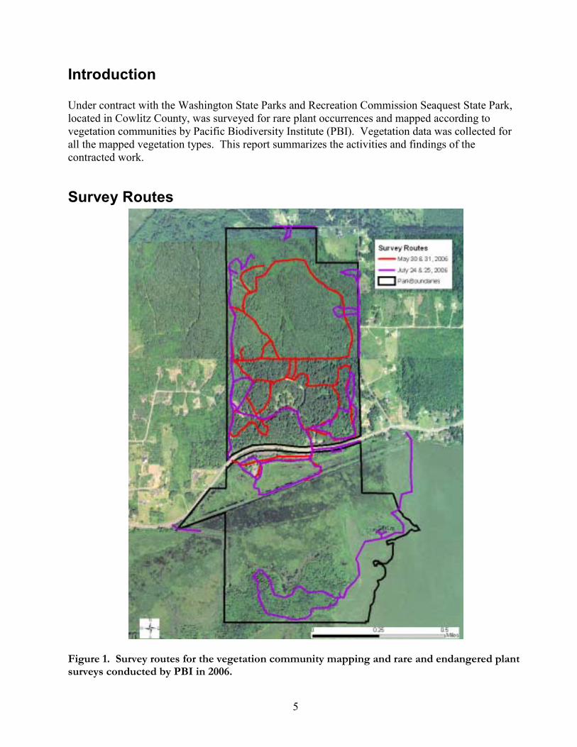
Survey Routes
Figure 1. Survey routes for the vegetation community mapping and rare and endangered plant surveys conducted by PBI in 2006.

6
Vegetation Communities
Methods Vegetation communities within Seaquest State Park were delineated and classified using a combination of field survey and remote sensing techniques. We relied on descriptions from the Washington State Department of Natural Resources (WADNR) late-seral forested plant associations of the Puget Lowland (Chappell 2004), and freshwater wetland vegetation (Kunze 1994). In some cases, the WADNR descriptions were not adequate in describing existing vegetation associations. In these cases, alternative vegetation communities or plant associations were created by PBI or found in alternative reference material. Remote sensing techniques consisted of manually delineating plant associations or mosaics of plant associations in a digital environment. We reviewed orthorectified aerial photography from the 1990s and recent ASTER and LANDSAT Thematic Mapper satellite images for discernable vegetation or landform patterns. We also used high resolution true color ortho-rectified aerial photography obtained from Washington Department of Natural Resources through Washington Department of Fish and Wildlife. Topographic maps, and digital elevation models (DEMs) were also employed to assist the process of vegetation community delineation. The vegetation polygons were created by hand in a GIS by ocular assessment. Field surveys consisted of visiting sites located within the vegetation polygons created during the remote sensing process. At representative sites within a polygon, vegetation data and site descriptions were recorded in a fashion consistent with the �plant community polygon� format provided by the Washington State Parks and Recreation Commission. Further refinements and editing of the vegetation polygon layers were done by hand on hardcopy maps in the field, and later edited digitally in a GIS.
Results We mapped and surveyed 37 vegetation community polygons, comprised of 16 vegetation community types, within Seaquest State Park. Vegetation community polygons are either stand-alone plant associations or mosaics of multiple plant associations. Table 1 lists the plant associations and/or cover types found in Seaquest State Park. See Appendix B for interpretation of �Status� codes. Figures 2 through 5 illustrate the location of the vegetation community polygons. Note that Figure 3 only shows the primary plant associations in each polygon (PA1 in the database). A printout of the complete set of data we collected for each polygon is attached in Appendix D. The ecological condition of each polygon was evaluated according to a simple ranking system described in Appendix C.
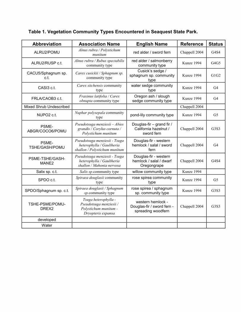
Table 1. Vegetation Community Types Encountered in Seaquest State Park.
Abbreviation Association Name English Name Reference StatusALRU2/POMU Alnus rubra / Polystichum
munitum red alder / sword fern Chappell 2004 G4S4
ALRU2/RUSP c.t. Alnus rubra / Rubus spectabilis community type
red alder / salmonberry community type Kunze 1994 G4G5
CACU5/Sphagnum sp. c.t.
Carex cusickii / Sphagnum sp. community type
Cusick�s sedge / sphagnum sp. community
type Kunze 1994 G1G2
CASI3 c.t. Carex sitchensis community type
water sedge community type Kunze 1994 G4
FRLA/CAOB3 c.t. Fraxinus latifolia / Carex obnupta community type
Oregon ash / slough sedge community type Kunze 1994 G4
Mixed Shrub Undescribed Chappell 2004
NUPO2 c.t. Nuphar polysepala community type pond-lily community type Kunze 1994 G5
PSME-ABGR/COCO6/POMU
Pseudotsuga menziesii � Abies grandis / Corylus cornuta /
Polystichum munitum
Douglas-fir � grand fir / California hazelnut /
sword fern Chappell 2004 G3S3
PSME-TSHE/GASH/POMU
Pseudotsuga menziesii - Tsuga heterophylla / Gaultheria
shallon / Polystichum munitum
Douglas-fir - western hemlock / salal / sword
fern Chappell 2004 G4
PSME-TSHE/GASH-MANE2
Pseudotsuga menziesii - Tsuga heterophylla / Gaultheria
shallon / Mahonia nervosa
Douglas-fir - western hemlock / salal / dwarf
Oregongrape Chappell 2004 G4S4
Salix sp. c.t. Salix sp.community type willow community type Kunze 1994
SPDO c.t. Spiraea douglasii community type
rose spirea community type Kunze 1994 G5
SPDO/Sphagnum sp. c.t. Spiraea douglasii / Sphagnum sp.community type
rose spirea / sphagnum sp. community type Kunze 1994 G3S3
TSHE-PSME/POMU-DREX2
Tsuga heterophylla - Pseudotsuga menziesii / Polystichum munitum -
Dryopteris expansa
western hemlock - Douglas-fir / sword fern -
spreading woodfern Chappell 2004 G3S3
developed Water

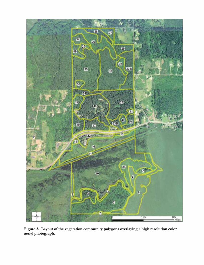
Figure 2. Layout of the vegetation community polygons overlaying a high resolution color aerial photograph.

10
Figure 3. The primary vegetation community types within Seaquest State Park.
11
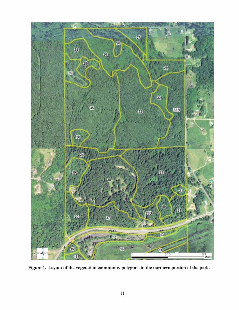
Figure 4. Layout of the vegetation community polygons in the northern portion of the park.

12
Figure 5. Layout of the vegetation community polygons in the southern portion of the park.
13
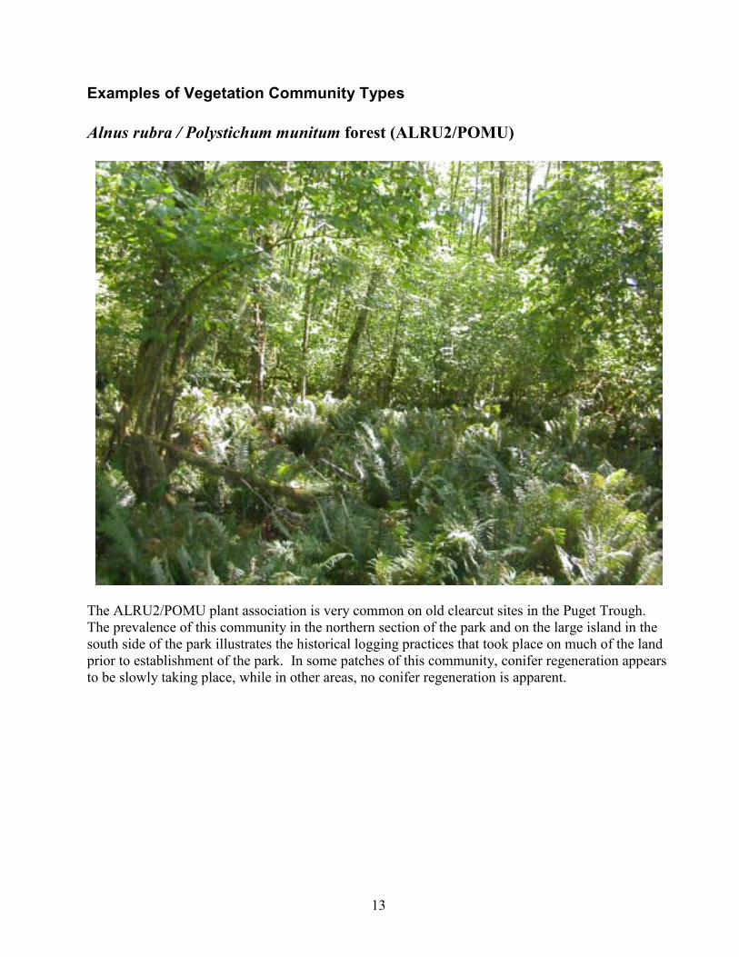
Examples of Vegetation Community Types Alnus rubra / Polystichum munitum forest (ALRU2/POMU)
The ALRU2/POMU plant association is very common on old clearcut sites in the Puget Trough. The prevalence of this community in the northern section of the park and on the large island in the south side of the park illustrates the historical logging practices that took place on much of the land prior to establishment of the park. In some patches of this community, conifer regeneration appears to be slowly taking place, while in other areas, no conifer regeneration is apparent.
14
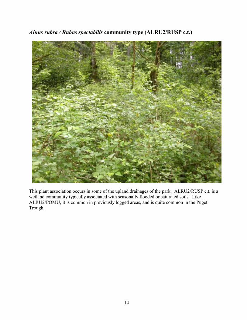
Alnus rubra / Rubus spectabilis community type (ALRU2/RUSP c.t.)
This plant association occurs in some of the upland drainages of the park. ALRU2/RUSP c.t. is a wetland community typically associated with seasonally flooded or saturated soils. Like ALRU2/POMU, it is common in previously logged areas, and is quite common in the Puget Trough.

15
Carex cusickii / Sphagnum sp. community type (CACU5/Sphagnum sp. c.t.)
This is a dominant matrix plant association within the large lake-margin wetlands in the southern part of the park. Within this association, thick mats of buckbean (Menyanthes trifoliata) extend out into the open water of Silver Lake, providing a support structure around which Sphagnum spp. grow. Large scattered patches of Carex cusickii occur within the sprawling mats of buckbean, and other Sphagnum community types as well as minerotrophic wetland community types occur as patches within the buckbean mat matrix. Nearer to the shoreline, Carex cusickii and Carex sitchensis become more dominant than Menyanthes trifoliata, and other species such Cicuta douglasii and Galium trifidum become more prevalent. The Carex cusickii/Sphagnum sp. c.t. is ecotonal between sphagnum bogs and minerotrophic wetlands.
16
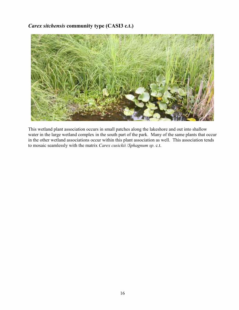
Carex sitchensis community type (CASI3 c.t.)
This wetland plant association occurs in small patches along the lakeshore and out into shallow water in the large wetland complex in the south part of the park. Many of the same plants that occur in the other wetland associations occur within this plant association as well. This association tends to mosaic seamlessly with the matrix Carex cusickii /Sphagnum sp. c.t.
17
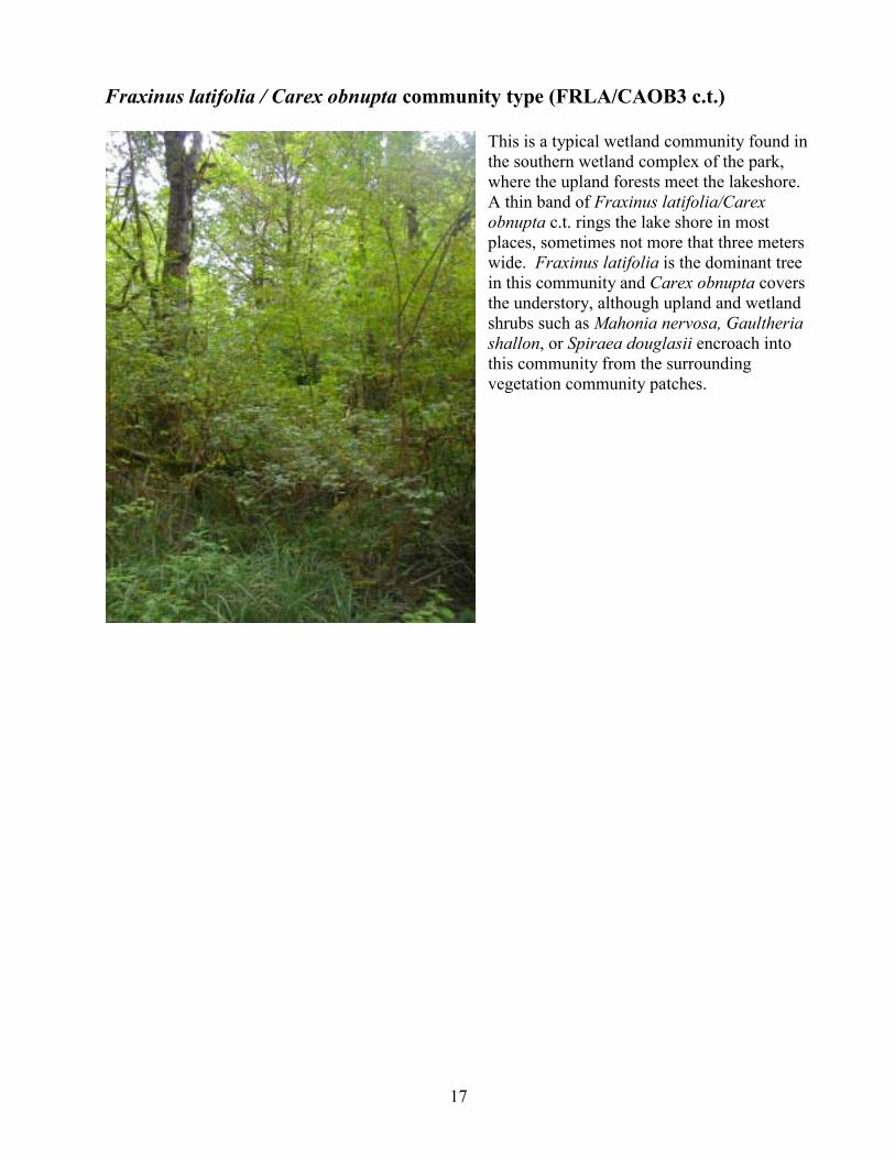
Fraxinus latifolia / Carex obnupta community type (FRLA/CAOB3 c.t.) This is a typical wetland community found in the southern wetland complex of the park, where the upland forests meet the lakeshore. A thin band of Fraxinus latifolia/Carex obnupta c.t. rings the lake shore in most places, sometimes not more that three meters wide. Fraxinus latifolia is the dominant tree in this community and Carex obnupta covers the understory, although upland and wetland shrubs such as Mahonia nervosa, Gaultheria shallon, or Spiraea douglasii encroach into this community from the surrounding vegetation community patches.
18
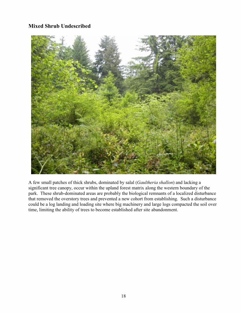
Mixed Shrub Undescribed
A few small patches of thick shrubs, dominated by salal (Gaultheria shallon) and lacking a significant tree canopy, occur within the upland forest matrix along the western boundary of the park. These shrub-dominated areas are probably the biological remnants of a localized disturbance that removed the overstory trees and prevented a new cohort from establishing. Such a disturbance could be a log landing and loading site where big machinery and large logs compacted the soil over time, limiting the ability of trees to become established after site abandonment.
19
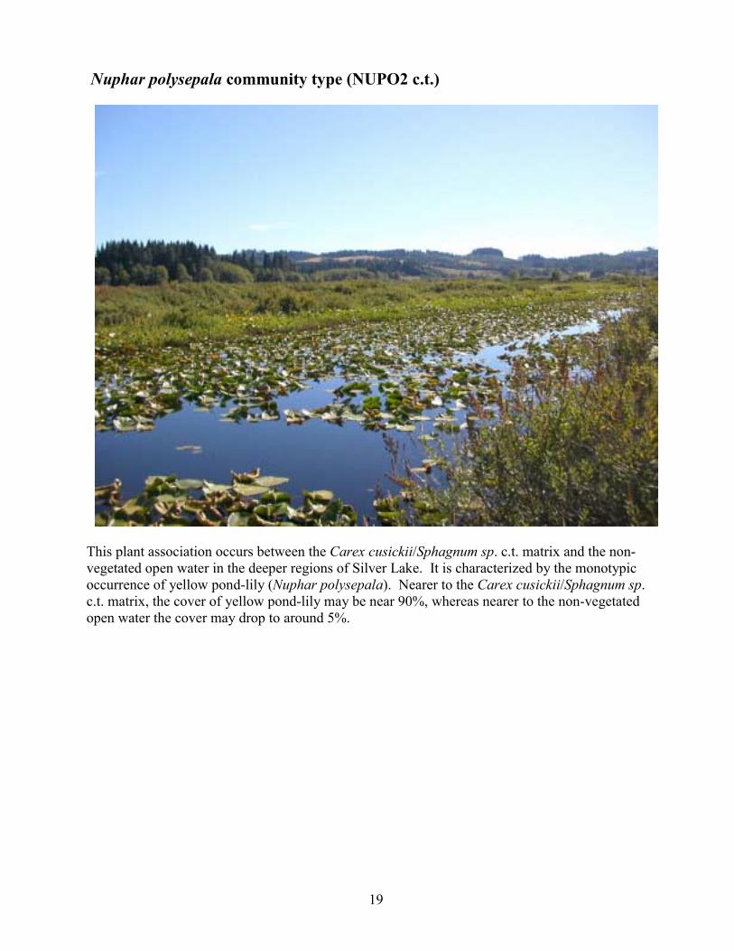
Nuphar polysepala community type (NUPO2 c.t.)
This plant association occurs between the Carex cusickii/Sphagnum sp. c.t. matrix and the non-vegetated open water in the deeper regions of Silver Lake. It is characterized by the monotypic occurrence of yellow pond-lily (Nuphar polysepala). Nearer to the Carex cusickii/Sphagnum sp. c.t. matrix, the cover of yellow pond-lily may be near 90%, whereas nearer to the non-vegetated open water the cover may drop to around 5%.
20
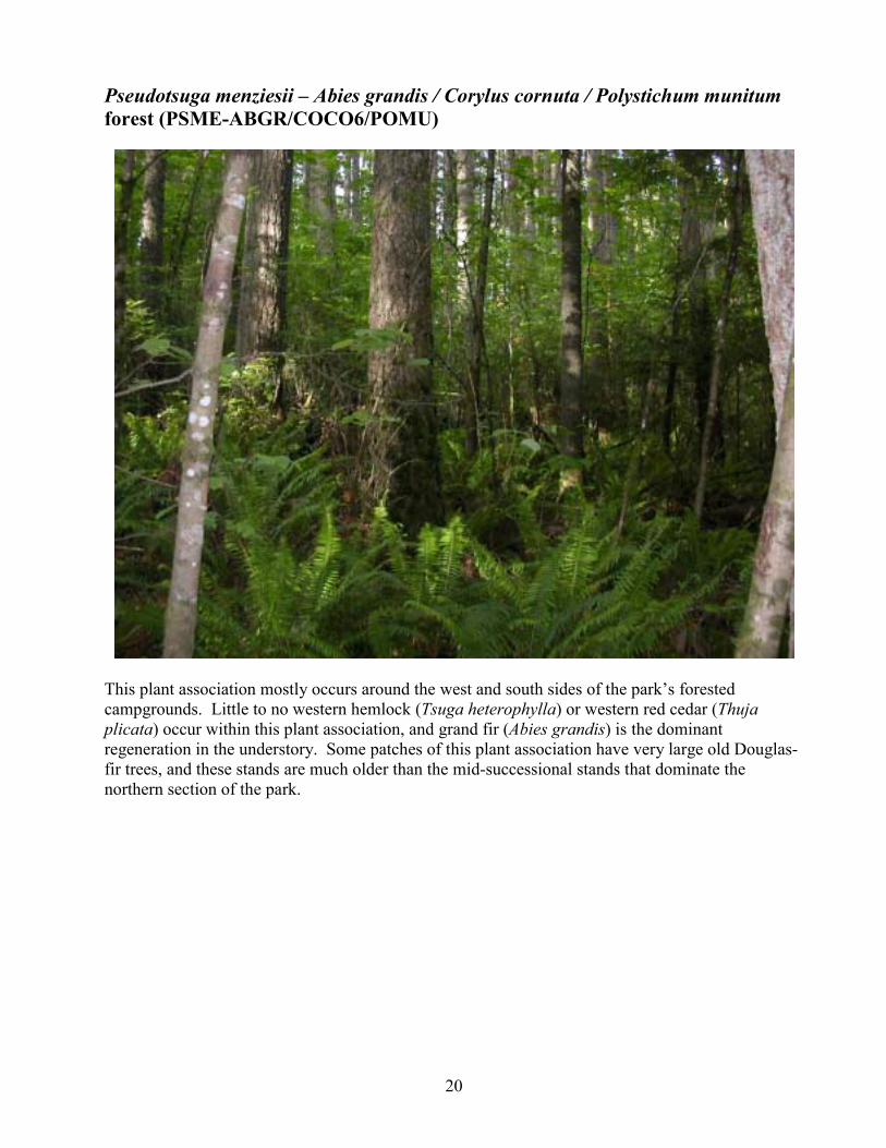
Pseudotsuga menziesii � Abies grandis / Corylus cornuta / Polystichum munitum forest (PSME-ABGR/COCO6/POMU)
This plant association mostly occurs around the west and south sides of the park�s forested campgrounds. Little to no western hemlock (Tsuga heterophylla) or western red cedar (Thuja plicata) occur within this plant association, and grand fir (Abies grandis) is the dominant regeneration in the understory. Some patches of this plant association have very large old Douglas-fir trees, and these stands are much older than the mid-successional stands that dominate the northern section of the park.

21
Pseudotsuga menziesii - Tsuga heterophylla / Gaultheria shallon / Polystichum munitum forest (PSME-TSHE/GASH/POMU)
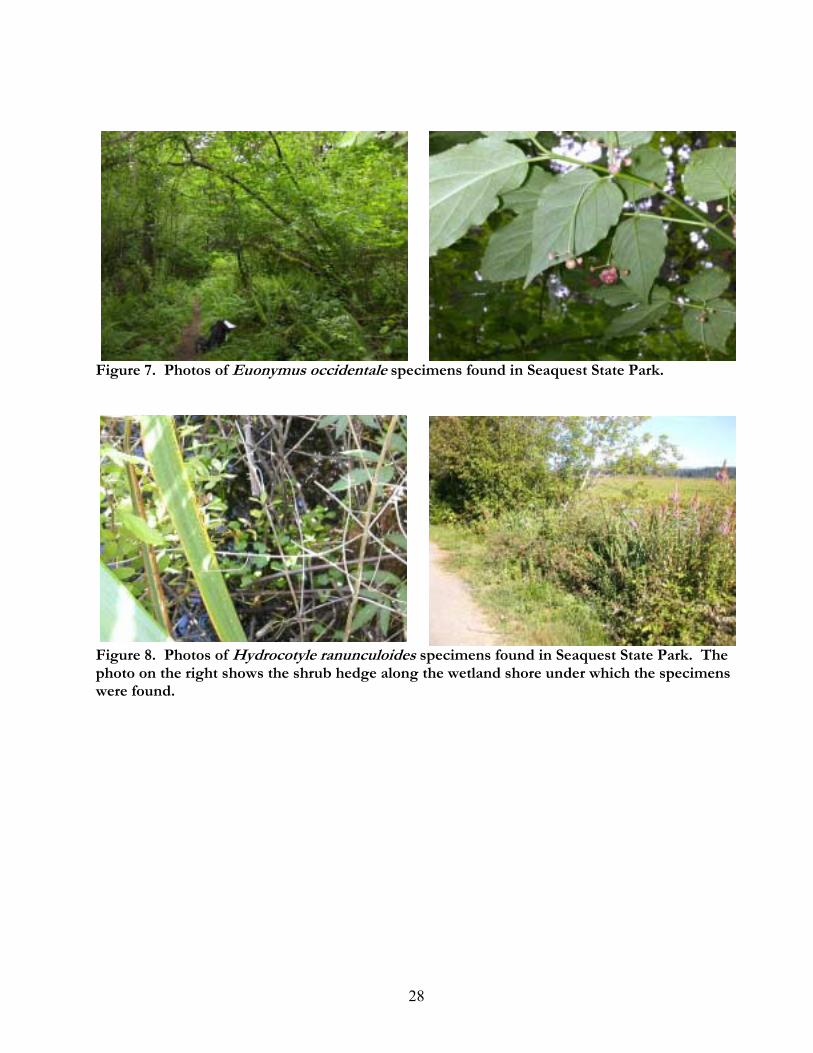
This is a common plant association in the eastern half of the upland forested portion of Seaquest State Park. Western red cedar (Thuja plicata) and Western hemlock (Tsuga heterophylla) are more common tree components in patches of this association, and salal (Gaultheria shallon) occurs throughout the understory mixing in with the typically dominant sword fern (Polystichum munitum). Some late-successional patches of this community occur around the east side of the park�s forested campgrounds. It is in one of these late-successional patches that a small group of the critically endangered Western wahoo (Euonymus occidentale) occurs.
22
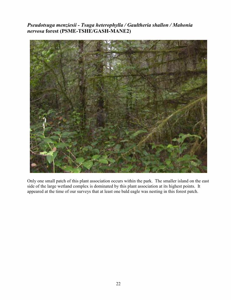
Pseudotsuga menziesii - Tsuga heterophylla / Gaultheria shallon / Mahonia nervosa forest (PSME-TSHE/GASH-MANE2)
Only one small patch of this plant association occurs within the park. The smaller island on the east side of the large wetland complex is dominated by this plant association at its highest points. It appeared at the time of our surveys that at least one bald eagle was nesting in this forest patch.
23
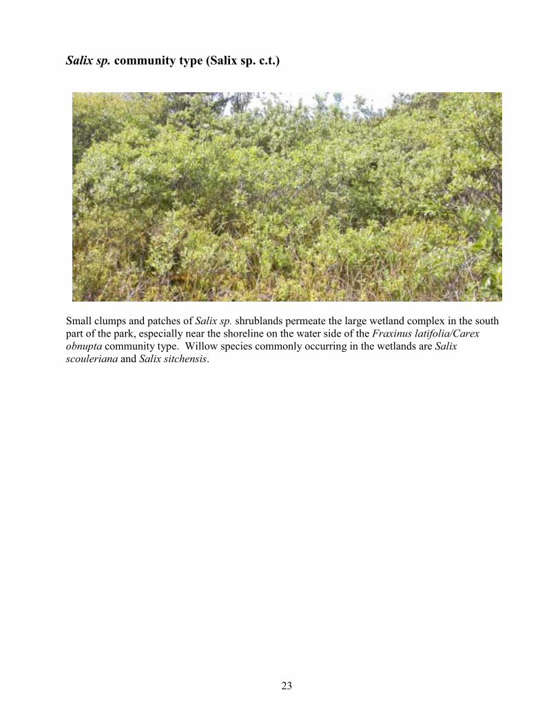
Salix sp. community type (Salix sp. c.t.)
Small clumps and patches of Salix sp. shrublands permeate the large wetland complex in the south part of the park, especially near the shoreline on the water side of the Fraxinus latifolia/Carex obnupta community type. Willow species commonly occurring in the wetlands are Salix scouleriana and Salix sitchensis.
24
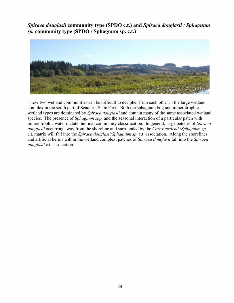
Spiraea douglasii community type (SPDO c.t.) and Spiraea douglasii / Sphagnum sp. community type (SPDO / Sphagnum sp. c.t.)
These two wetland communities can be difficult to decipher from each other in the large wetland complex in the south part of Seaquest State Park. Both the sphagnum bog and minerotrophic wetland types are dominated by Spiraea douglasii and contain many of the same associated wetland species. The presence of Sphagnum spp. and the seasonal interaction of a particular patch with minerotrophic water dictate the final community classification. In general, large patches of Spiraea douglasii occurring away from the shoreline and surrounded by the Carex cusickii /Sphagnum sp. c.t. matrix will fall into the Spiraea douglasii/Sphagnum sp. c.t. association. Along the shorelines and artificial berms within the wetland complex, patches of Spiraea douglasii fall into the Spiraea douglasii c.t. association.
25
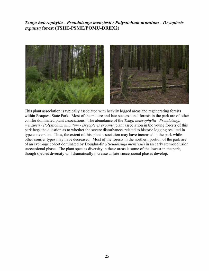
Tsuga heterophylla - Pseudotsuga menziesii / Polystichum munitum - Dryopteris expansa forest (TSHE-PSME/POMU-DREX2)
This plant association is typically associated with heavily logged areas and regenerating forests within Seaquest State Park. Most of the mature and late-successional forests in the park are of other conifer dominated plant associations. The abundance of the Tsuga heterophylla - Pseudotsuga menziesii / Polystichum munitum - Dryopteris expansa plant association in the young forests of this park begs the question as to whether the severe disturbances related to historic logging resulted in type conversion. Thus, the extent of this plant association may have increased in the park while other conifer types may have decreased. Most of the forests in the northern portion of the park are of an even-age cohort dominated by Douglas-fir (Pseudotsuga menziesii) in an early stem-seclusion successional phase. The plant species diversity in these areas is some of the lowest in the park, though species diversity will dramatically increase as late-successional phases develop.

26
Rare Plant Surveys
Methods We visited Seaquest State Park multiple times during the 2006 field season to conduct a rare plant survey. We used the Washington Department of Natural Resources Natural Heritage Program�s (DNR NHP) rare plant list to determine the conservation status of vascular plants encountered in the field. When a plant from the DNR NHP list was located, we used the standard DNR NHP rare plant sighting form to complete field descriptions for the observation. These forms are attached as Appendix E to this report. Field surveys were conducted on May 30 and 31, and July 24 and 25, 2006. During the field surveys, we were equipped with reference literature, rare plant lists for the area, maps showing rare plant locations from previous surveys, and a portable plant identification lab. We looked for rare plants in habitats previously identified as being likely occurrence sites. So as not to miss a rare plant, all vascular plant species encountered during the inventory were identified on site, at base camp in the portable laboratory, or back at our office. Survey routes were determined based on the desire to efficiently cover a large proportion of the park�s area throughout the field season. We surveyed habitats of the park where we felt rare plants were more likely to occur more intensively. Survey routes for the rare plant inventory and rare plant locations were recorded either by hand, on a hardcopy topographic map, or as GPS waypoints and trackpoints, all of which were later compiled into a single GIS data layer (Figure 1).
Results
Rare Plants We located two vascular plants currently listed in the WA DNR NHP rare plant list within Seaquest State Park. The locations of these plants and photos of the specimens are illustrated in Figures 6 � 8. See Appendix E for a full printout of the DNR NHP field sighting forms. See Appendix B for definitions of Status codes. Species Common Name Status Euonymus occidentale Nutt. ex Torr. western burning bush G5-S1-T Hydrocotyle ranunculoides L. f. floating marshpennywort G5-S2-S
27
Figure 6. General locations of rare plants within Seaquest State Park.
Rare plant info redacted. Contact Washington State Parks and Recreation Commission for further information.
28
Figure 7. Photos of Euonymus occidentale specimens found in Seaquest State Park.
Figure 8. Photos of Hydrocotyle ranunculoides specimens found in Seaquest State Park. The photo on the right shows the shrub hedge along the wetland shore under which the specimens were found.

29
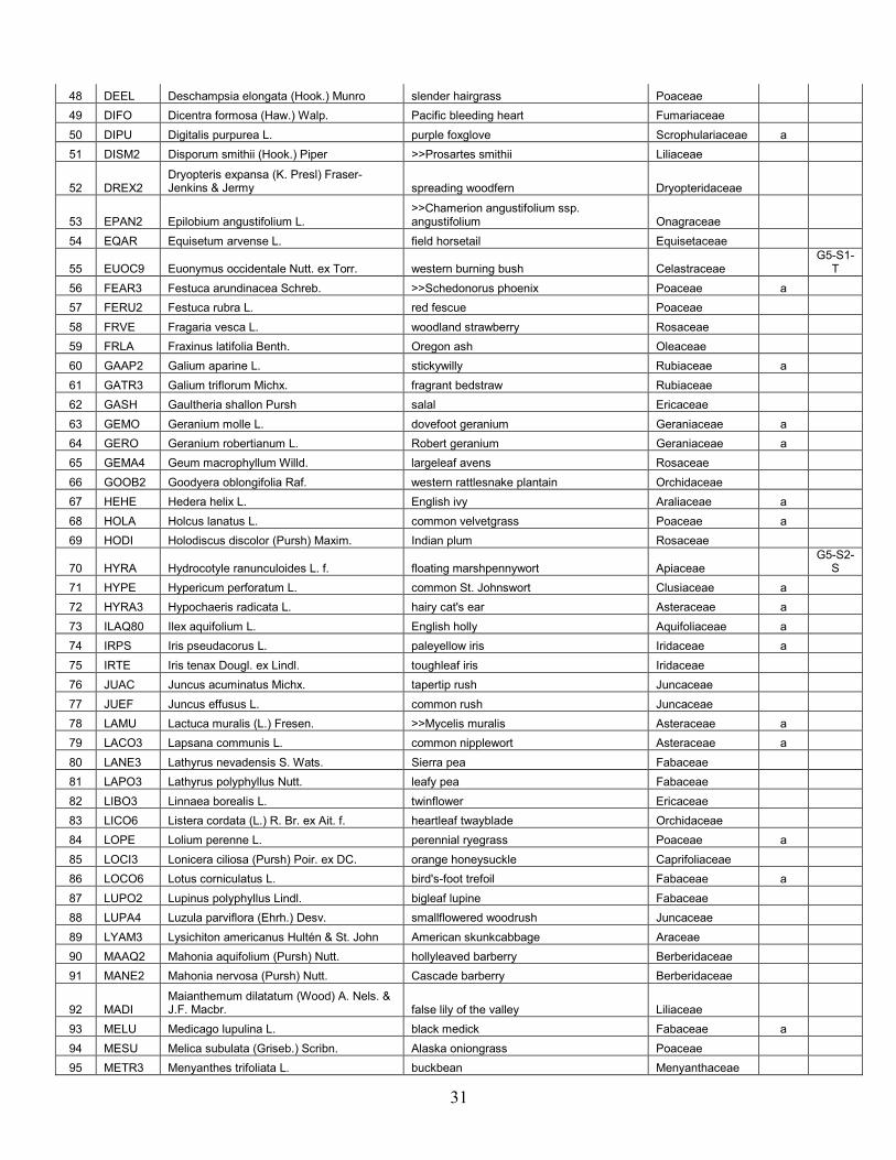
Vascular Plant List for Seaquest State Park A total of 189 vascular plant species were identified during the 2006 surveys at Seaquest State Park. Of these, 60 of the plant species are non-native, accounting for 32% of the total. Key to Vascular Plant Species List �Code�: Four-letter plant code as shown on the USDA PLANTS database. �Alien?�: species that are not native to the park are indicated with an �a� �Status�: Current status listings for WA DNR NHP tracked rare plants. See Appendix B for definitions of Status rankings. �Common Name / Accepted Synonym�: The species list uses Hitchcock and Cronquist, Flora of the Pacific Northwest as the taxonomic authority, as this is still the standard reference for our area. Updated nomenclature or general common names are shown in this column when they exist.

Table 2. Vascular Plant List for Seaquest State Park num Code Scientific Name Common Name/Accepted Synonym Family alien? Status
1 ABGR Abies grandis (Dougl. ex D. Don) Lindl. grand fir Pinaceae 2 ACCI Acer circinatum Pursh vine maple Aceraceae 3 ACMA3 Acer macrophyllum Pursh bigleaf maple Aceraceae 4 ACTR Achlys triphylla (Sm.) DC. sweet after death Berberidaceae 5 ADBI Adenocaulon bicolor Hook. pathfinder Asteraceae 6 AGEX Agrostis exarata Trin. spike bentgrass Poaceae 7 AICA Aira caryophyllea L. silver hairgrass Poaceae a 8 AIPR Aira praecox L. yellow hairgrass Poaceae a 9 ALRU2 Alnus rubra Bong. red alder Betulaceae
10 AMAL2 Amelanchier alnifolia (Nutt.) Nutt. ex M. Roemer Saskatoon serviceberry Rosaceae
11 ANMA Anaphalis margaritacea (L.) Benth. western pearly everlasting Asteraceae 12 ANDE3 Anemone deltoidea Hook. Columbian windflower Ranunculaceae 13 ANOD Anthoxanthum odoratum L. sweet vernalgrass Poaceae a 14 AQFO Aquilegia formosa Fisch. ex DC. western columbine Ranunculaceae 15 ARME Arbutus menziesii Pursh madrone Ericaceae 16 ARMI2 Arctium minus Bernh. lesser burdock Asteraceae a
17 AREL3 Arrhenatherum elatius (L.) Beauv. ex J.& K. Presl tall oatgrass Poaceae a
18 ATFI Athyrium filix-femina (L.) Roth common ladyfern Dryopteridaceae 19 BEPE2 Bellis perennis L. lawn daisy Asteraceae a 20 BLSP Blechnum spicant (L.) Sm. deer fern Blechnaceae 21 BRSY Brachypodium sylvaticum (Huds.) Beauv. slender false brome Poaceae a 22 BRMO2 Bromus mollis auct. non L. [misapplied] >>Bromus hordeaceus ssp. hordeaceus Poaceae a 23 BRPA3 Bromus pacificus Shear Pacific brome Poaceae 24 BRVU Bromus vulgaris (Hook.) Shear Columbia brome Poaceae 25 CASC7 Campanula scouleri Hook. ex A. DC. pale bellflower Campanulaceae 26 CAOL Cardamine oligosperma Nutt. little western bittercress Brassicaceae 27 CACA11 Carex canescens L. silvery sedge Cyperaceae
28 CACU5 Carex cusickii Mackenzie ex Piper & Beattie Cusick's sedge Cyperaceae
29 CADE9 Carex deweyana Schwein. Dewey sedge Cyperaceae 30 CAHE7 Carex hendersonii Bailey Henderson's sedge Cyperaceae 31 CAOB3 Carex obnupta Bailey slough sedge Cyperaceae 32 CAPA14 Carex pachystachya Cham. ex Steud. chamisso sedge Cyperaceae 33 CASI3 Carex sitchensis Prescott ex Bong. >>Carex aquatilis var. dives Cyperaceae 34 CAVE6 Carex vesicaria L. blister sedge Cyperaceae 35 CEGL2 Cerastium glomeratum Thuill. sticky chickweed Caryophyllaceae a 36 CEVU Cerastium vulgatum L. 1762, non 1755 >>Cerastium fontanum ssp. vulgare Caryophyllaceae a 37 CIDO Cicuta douglasii (DC.) Coult. & Rose western water hemlock Apiaceae 38 CIAL Circaea alpina L. small enchanter's nightshade Onagraceae 39 CIAR4 Cirsium arvense (L.) Scop. Canada thistle Asteraceae a 40 COHE2 Collomia heterophylla Dougl. ex Hook. variableleaf collomia Polemoniaceae 41 COMA25 Corallorhiza maculata (Raf.) Raf. summer coralroot Orchidaceae 42 CONU4 Cornus nuttallii Audubon ex Torr. & Gray Pacific dogwood Cornaceae 43 COST4 Cornus stolonifera Michx. >>Cornus sericea ssp. sericea Cornaceae 44 COCO6 Corylus cornuta Marsh. California hazelnut Betulaceae 45 CRCA3 Crepis capillaris (L.) Wallr. smooth hawksbeard Asteraceae a 46 CYSC4 Cytisus scoparius (L.) Link scotchbroom Fabaceae a 47 DAGL Dactylis glomerata L. orchardgrass Poaceae a
31
48 DEEL Deschampsia elongata (Hook.) Munro slender hairgrass Poaceae 49 DIFO Dicentra formosa (Haw.) Walp. Pacific bleeding heart Fumariaceae 50 DIPU Digitalis purpurea L. purple foxglove Scrophulariaceae a 51 DISM2 Disporum smithii (Hook.) Piper >>Prosartes smithii Liliaceae
52 DREX2 Dryopteris expansa (K. Presl) Fraser-Jenkins & Jermy spreading woodfern Dryopteridaceae
53 EPAN2 Epilobium angustifolium L. >>Chamerion angustifolium ssp. angustifolium Onagraceae
54 EQAR Equisetum arvense L. field horsetail Equisetaceae
55 EUOC9 Euonymus occidentale Nutt. ex Torr. western burning bush Celastraceae G5-S1-
T 56 FEAR3 Festuca arundinacea Schreb. >>Schedonorus phoenix Poaceae a 57 FERU2 Festuca rubra L. red fescue Poaceae 58 FRVE Fragaria vesca L. woodland strawberry Rosaceae 59 FRLA Fraxinus latifolia Benth. Oregon ash Oleaceae 60 GAAP2 Galium aparine L. stickywilly Rubiaceae a 61 GATR3 Galium triflorum Michx. fragrant bedstraw Rubiaceae 62 GASH Gaultheria shallon Pursh salal Ericaceae 63 GEMO Geranium molle L. dovefoot geranium Geraniaceae a 64 GERO Geranium robertianum L. Robert geranium Geraniaceae a 65 GEMA4 Geum macrophyllum Willd. largeleaf avens Rosaceae 66 GOOB2 Goodyera oblongifolia Raf. western rattlesnake plantain Orchidaceae 67 HEHE Hedera helix L. English ivy Araliaceae a 68 HOLA Holcus lanatus L. common velvetgrass Poaceae a 69 HODI Holodiscus discolor (Pursh) Maxim. Indian plum Rosaceae
70 HYRA Hydrocotyle ranunculoides L. f. floating marshpennywort Apiaceae G5-S2-
S 71 HYPE Hypericum perforatum L. common St. Johnswort Clusiaceae a 72 HYRA3 Hypochaeris radicata L. hairy cat's ear Asteraceae a 73 ILAQ80 Ilex aquifolium L. English holly Aquifoliaceae a 74 IRPS Iris pseudacorus L. paleyellow iris Iridaceae a 75 IRTE Iris tenax Dougl. ex Lindl. toughleaf iris Iridaceae 76 JUAC Juncus acuminatus Michx. tapertip rush Juncaceae 77 JUEF Juncus effusus L. common rush Juncaceae 78 LAMU Lactuca muralis (L.) Fresen. >>Mycelis muralis Asteraceae a 79 LACO3 Lapsana communis L. common nipplewort Asteraceae a 80 LANE3 Lathyrus nevadensis S. Wats. Sierra pea Fabaceae 81 LAPO3 Lathyrus polyphyllus Nutt. leafy pea Fabaceae 82 LIBO3 Linnaea borealis L. twinflower Ericaceae 83 LICO6 Listera cordata (L.) R. Br. ex Ait. f. heartleaf twayblade Orchidaceae 84 LOPE Lolium perenne L. perennial ryegrass Poaceae a 85 LOCI3 Lonicera ciliosa (Pursh) Poir. ex DC. orange honeysuckle Caprifoliaceae 86 LOCO6 Lotus corniculatus L. bird's-foot trefoil Fabaceae a 87 LUPO2 Lupinus polyphyllus Lindl. bigleaf lupine Fabaceae 88 LUPA4 Luzula parviflora (Ehrh.) Desv. smallflowered woodrush Juncaceae 89 LYAM3 Lysichiton americanus Hultén & St. John American skunkcabbage Araceae 90 MAAQ2 Mahonia aquifolium (Pursh) Nutt. hollyleaved barberry Berberidaceae 91 MANE2 Mahonia nervosa (Pursh) Nutt. Cascade barberry Berberidaceae
92 MADI Maianthemum dilatatum (Wood) A. Nels. & J.F. Macbr. false lily of the valley Liliaceae
93 MELU Medicago lupulina L. black medick Fabaceae a 94 MESU Melica subulata (Griseb.) Scribn. Alaska oniongrass Poaceae 95 METR3 Menyanthes trifoliata L. buckbean Menyanthaceae

32
96 MICA5 Mitella caulescens Nutt. slightstemmed miterwort Saxifragaceae 97 MOSI2 Montia sibirica (L.) T.J. Howell >>Claytonia sibirica var. sibirica Portulacaceae 98 MYOSO Myosotis L. forget-me-not Boraginaceae 99 MYLA Myosotis laxa Lehm. bay forget-me-not Boraginaceae 100 NEPA Nemophila parviflora Dougl. ex Benth. smallflower nemophila Hydrophyllaceae 101 NUPO2 Nuphar polysepala Engelm. >>Nuphar lutea ssp. polysepala Nymphaeaceae
102 OECE Oemleria cerasiformis (Torr. & Gray ex Hook. & Arn.) Landon Indian plum Rosaceae
103 OESA Oenanthe sarmentosa K. Presl ex DC. water parsely Apiaceae 104 OSCH Osmorhiza chilensis Hook. & Arn. >>Osmorhiza berteroi Apiaceae 105 OXTR Oxalis trilliifolia Hook. threeleaf woodsorrel Oxalidaceae 106 PEPA31 Petasites palmatus (Ait.) Gray >>Petasites frigidus var. palmatus Asteraceae 107 PHAR3 Phalaris arundinacea L. reed canarygrass Poaceae a 108 PHCA11 Physocarpus capitatus (Pursh) Kuntze Pacific ninebark Rosaceae 109 PLMA2 Plantago major L. common plantain Plantaginaceae 110 POAN Poa annua L. annual bluegrass Poaceae a 111 POCO Poa compressa L. Canada bluegrass Poaceae a 112 POPR Poa pratensis L. Kentucky bluegrass Poaceae a 113 POTR2 Poa trivialis L. rough bluegrass Poaceae a 114 POHY Polygonum hydropiper L. marshpepper knotweed Polygonaceae a
115 POSA4 Polygonum sachalinense F. Schmidt ex Maxim. giant knotweed Polygonaceae a
116 POGL8 Polypodium glycyrrhiza D.C. Eat. licorice fern Polypodiaceae 117 POMU Polystichum munitum (Kaulfuss) K. Presl swordfern Polypodiaceae
118 POBAT Populus balsamifera L. ssp. trichocarpa (Torr. & Gray ex Hook.) Brayshaw black cottonwood Salicaceae
119 POTR5 Populus tremuloides Michx. quaking aspen Salicaceae 120 POPA14 Potentilla palustris (L.) Scop. >>Comarum palustre Rosaceae 121 PRVU Prunella vulgaris L. common selfheal Lamiaceae
122 PREM Prunus emarginata (Dougl. ex Hook.) D. Dietr. bitter cherry Rosaceae
123 PRLA5 Prunus laurocerasus L. cherry laurel Rosaceae a 124 PSME Pseudotsuga menziesii (Mirbel) Franco Douglas-fir Pinaceae 125 PTAQ Pteridium aquilinum (L.) Kuhn bracken fern Dennstaedtiaceae 126 PYFU Pyrus fusca Raf. >>Malus fusca Rosaceae 127 QUGA4 Quercus garryana Dougl. ex Hook. Oregon white oak Fagaceae 128 RARE3 Ranunculus repens L. creeping buttercup Ranunculaceae a 129 RAUN Ranunculus uncinatus D. Don ex G. Don woodland buttercup Ranunculaceae a 130 RHPU Rhamnus purshiana DC. >>Frangula purshiana Rhamnaceae 131 RIDI Ribes divaricatum Dougl. spreading gooseberry Grossulariaceae 132 ROGY Rosa gymnocarpa Nutt. dwarf rose Rosaceae 133 RONU Rosa nutkana K. Presl Nootka rose Asteraceae 134 RUDI2 Rubus discolor Weihe & Nees >>Rubus armeniacus Rosaceae a 135 RULA Rubus laciniatus Willd. cutleaf blackberry Rosaceae a 136 RULE Rubus leucodermis Dougl. ex Torr. & Gray whitebark raspberry Rosaceae 137 RUPA Rubus parviflorus Nutt. thimbleberry Rosaceae 138 RUSP Rubus spectabilis Pursh salmonberry Rosaceae 139 RUUR Rubus ursinus Cham. & Schlecht. California blackberry Rosaceae 140 RUCR Rumex crispus L. curly dock Polygonaceae a 141 RUOB Rumex obtusifolius L. bitter dock Polygonaceae a 142 SAPR Sagina procumbens L. birdeye pearlwort Caryophyllaceae a 143 SAGE2 Salix geyeriana Anderss. Geyer willow Salicaceae

33
144 SASC Salix scouleriana Barratt ex Hook. Scouler's willow Salicaceae 145 SASI2 Salix sitchensis Sanson ex Bong. Sitka willow Salicaceae 146 SARA2 Sambucus racemosa L. red elderberry Caprifoliaceae 147 SACR2 Sanicula crassicaulis Poepp. ex DC. >>Sagina maxima ssp. crassicaulis Apiaceae 148 SADO5 Satureja douglasii (Benth.) Briq. >>Clinopodium douglasii Lamiaceae 149 SCLA2 Scutellaria lateriflora L. blue skullcap Lamiaceae 150 SEJA Senecio jacobaea L. stinking willie Asteraceae a 151 SETR Senecio triangularis Hook. arrowleaf ragwort Asteraceae 152 SEVU Senecio vulgaris L. old-man-in-the-Spring Asteraceae a
153 SMRA* Smilacina racemosa (L) Desf. >>Maianthemum racemosum ssp. amplexicaule Liliaceae
154 SMST Smilacina stellata (L.) Desf. >>Maianthemum stellatum Liliaceae 155 SODU Solanum dulcamara L. climbing nightshade Solanaceae a 156 SOUL5 Sonchus uliginosus Bieb. >>Sonchus arvensis ssp. uliginosus Asteraceae a 157 SPDO Spiraea douglasii Hook. rose spirea Rosaceae 158 STCO14 Stachys cooleyae Heller >>Stachys chamissonis var. cooleyae Lamiaceae 159 STCA Stellaria calycantha (Ledeb.) Bong. northern starwort Caryophyllaceae 160 STCR2 Stellaria crispa Cham. & Schlecht. curled starwort Caryophyllaceae 161 STME2 Stellaria media (L.) Vill. common chickweed Caryophyllaceae a 162 SYAL Symphoricarpos albus (L.) Blake common snowberry Caprifoliaceae
163 TAOF Taraxacum officinale G.H. Weber ex Wiggers dandelion Asteraceae a
164 TABR2 Taxus brevifolia Nutt. Pacific yew Taxaceae 165 THPL Thuja plicata Donn ex D. Don western red cedar Cupressaceae 166 TITR Tiarella trifoliata L. threeleaf foamflower Saxifragaceae 167 TOME Tolmiea menziesii (Pursh) Torr. & Gray youth on age Saxifragaceae 168 TRLA6 Trientalis latifolia Hook. >>Trientalis borealis ssp. latifolia Primulaceae 169 TRPR2 Trifolium pratense L. red clover Fabaceae a 170 TRRE3 Trifolium repens L. white clover Fabaceae a 171 TROV2 Trillium ovatum Pursh Pacific trillium Liliaceae 172 TRCE2 Trisetum cernuum Trin. >>Trisetum canescens Poaceae 173 TSHE Tsuga heterophylla (Raf.) Sarg. western hemlock Pinaceae 174 TYLA Typha latifolia L. broadleaf cattail Typhaceae 175 URDI Urtica dioica L. nettle Urticaceae 176 UTIN Utricularia inflata Walt. swollen bladderwort Lentibulariaceae a 177 VAPA Vaccinium parvifolium Sm. red huckleberry Ericaceae
178 VAHE Vancouveria hexandra (Hook.) Morr. & Dcne. white insideout flower Berberidaceae
179 VERAT Veratrum L. false hellebore Liliaceae 180 VEAM2 Veronica americana Schwein. ex Benth. American speedwell Scrophulariaceae 181 VEOF2 Veronica officinalis L. common gypsyweed Scrophulariaceae a 182 VESE Veronica serpyllifolia L. thymeleaf speedwell Scrophulariaceae a 183 VIAM Vicia americana Muhl. ex Willd. American vetch Fabaceae 184 VIHI Vicia hirsuta (L.) S.F. Gray tiny vetch Fabaceae a 185 VISA Vicia sativa L. garden vetch Fabaceae a 186 VIMA Vinca major L. bigleaf periwinkle Apocynaceae a 187 VIGL Viola glabella Nutt. pioneer violet Violaceae 188 VISE3 Viola sempervirens Greene evergreen violet Violaceae 189 VUBR Vulpia bromoides (L.) S.F. Gray brome fescue Poaceae a
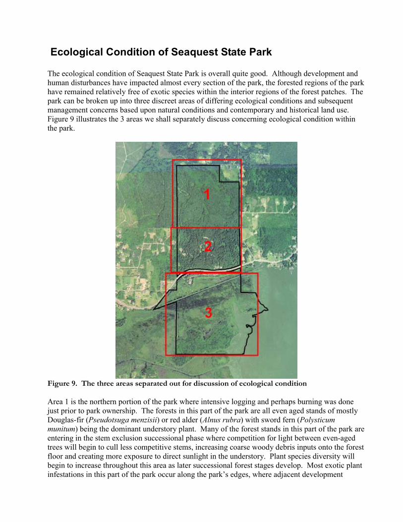
Ecological Condition of Seaquest State Park The ecological condition of Seaquest State Park is overall quite good. Although development and human disturbances have impacted almost every section of the park, the forested regions of the park have remained relatively free of exotic species within the interior regions of the forest patches. The park can be broken up into three discreet areas of differing ecological conditions and subsequent management concerns based upon natural conditions and contemporary and historical land use. Figure 9 illustrates the 3 areas we shall separately discuss concerning ecological condition within the park.
Figure 9. The three areas separated out for discussion of ecological condition Area 1 is the northern portion of the park where intensive logging and perhaps burning was done just prior to park ownership. The forests in this part of the park are all even aged stands of mostly Douglas-fir (Pseudotsuga menzisii) or red alder (Alnus rubra) with sword fern (Polysticum munitum) being the dominant understory plant. Many of the forest stands in this part of the park are entering in the stem exclusion successional phase where competition for light between even-aged trees will begin to cull less competitive stems, increasing coarse woody debris inputs onto the forest floor and creating more exposure to direct sunlight in the understory. Plant species diversity will begin to increase throughout this area as later successional forest stages develop. Most exotic plant infestations in this part of the park occur along the park�s edges, where adjacent development
35
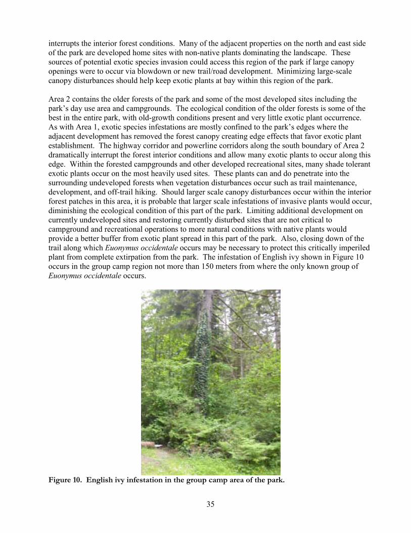
interrupts the interior forest conditions. Many of the adjacent properties on the north and east side of the park are developed home sites with non-native plants dominating the landscape. These sources of potential exotic species invasion could access this region of the park if large canopy openings were to occur via blowdown or new trail/road development. Minimizing large-scale canopy disturbances should help keep exotic plants at bay within this region of the park. Area 2 contains the older forests of the park and some of the most developed sites including the park�s day use area and campgrounds. The ecological condition of the older forests is some of the best in the entire park, with old-growth conditions present and very little exotic plant occurrence. As with Area 1, exotic species infestations are mostly confined to the park�s edges where the adjacent development has removed the forest canopy creating edge effects that favor exotic plant establishment. The highway corridor and powerline corridors along the south boundary of Area 2 dramatically interrupt the forest interior conditions and allow many exotic plants to occur along this edge. Within the forested campgrounds and other developed recreational sites, many shade tolerant exotic plants occur on the most heavily used sites. These plants can and do penetrate into the surrounding undeveloped forests when vegetation disturbances occur such as trail maintenance, development, and off-trail hiking. Should larger scale canopy disturbances occur within the interior forest patches in this area, it is probable that larger scale infestations of invasive plants would occur, diminishing the ecological condition of this part of the park. Limiting additional development on currently undeveloped sites and restoring currently disturbed sites that are not critical to campground and recreational operations to more natural conditions with native plants would provide a better buffer from exotic plant spread in this part of the park. Also, closing down of the trail along which Euonymus occidentale occurs may be necessary to protect this critically imperiled plant from complete extirpation from the park. The infestation of English ivy shown in Figure 10 occurs in the group camp region not more than 150 meters from where the only known group of Euonymus occidentale occurs.
Figure 10. English ivy infestation in the group camp area of the park.
36
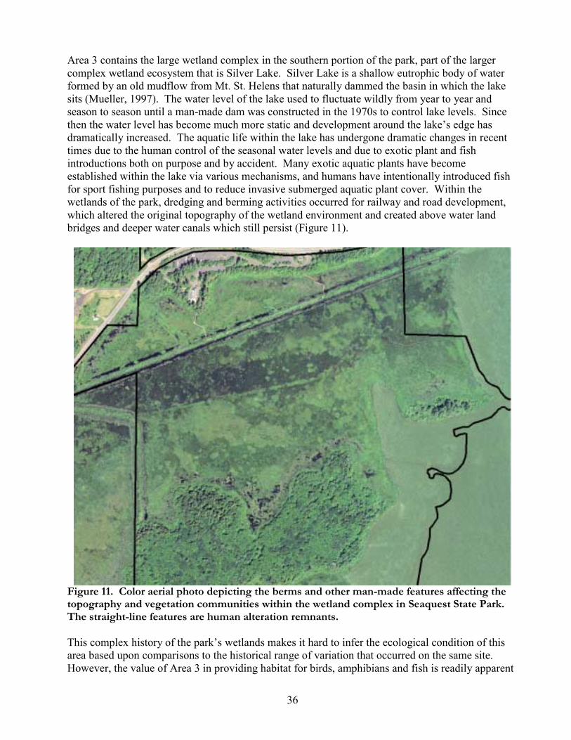
Area 3 contains the large wetland complex in the southern portion of the park, part of the larger complex wetland ecosystem that is Silver Lake. Silver Lake is a shallow eutrophic body of water formed by an old mudflow from Mt. St. Helens that naturally dammed the basin in which the lake sits (Mueller, 1997). The water level of the lake used to fluctuate wildly from year to year and season to season until a man-made dam was constructed in the 1970s to control lake levels. Since then the water level has become much more static and development around the lake�s edge has dramatically increased. The aquatic life within the lake has undergone dramatic changes in recent times due to the human control of the seasonal water levels and due to exotic plant and fish introductions both on purpose and by accident. Many exotic aquatic plants have become established within the lake via various mechanisms, and humans have intentionally introduced fish for sport fishing purposes and to reduce invasive submerged aquatic plant cover. Within the wetlands of the park, dredging and berming activities occurred for railway and road development, which altered the original topography of the wetland environment and created above water land bridges and deeper water canals which still persist (Figure 11).
Figure 11. Color aerial photo depicting the berms and other man-made features affecting the topography and vegetation communities within the wetland complex in Seaquest State Park. The straight-line features are human alteration remnants. This complex history of the park�s wetlands makes it hard to infer the ecological condition of this area based upon comparisons to the historical range of variation that occurred on the same site. However, the value of Area 3 in providing habitat for birds, amphibians and fish is readily apparent

37
regardless of what the historic conditions were like. The wetlands also support a population of Hydrocotyle ranunculoides, a state sensitive aquatic plant. Most of the wetlands within the park are composed of native wetland plants that indicate a generally good ecological condition for the wetland complex. Exotic species controls are not suggested at this time, though continued monitoring of the wetlands for dramatic increases in exotic plants should occur. The upland sites within Area 3, which include the upper portion of the man-made berms and the larger islands are in various states of ecological condition. Large infestations on non-native plants occur along berms, with Himalayan blackberry and reed canary grass as the worst exotic invaders in the un-maintained portions of the berms. Where maintained trails exist along the berms, non-native grasses and herbs are readily established. Along some portions of the berms native plant communities without exotic plants have become established, although this is a less common occurrence. On the two islands natural forest types occur. Logging has occurred on the large island and the subsequent ALRU2/POMU forest patches that dominant the island have periodic infestations on non-native plants. These areas could benefit from restoration activities such as cutting back exotic vines and grasses and planting native conifers and shrubs to encourage forest growth. A number of deer were seen using the large island during our surveys.

38
GIS Products Produced Associated with this report is a polygon layer created by PBI depicting the vegetation community types mapped in Seaquest State Park. The dataset has been converted into ESRI shapefile format and provided to the Washington State Parks and Recreation Commission. Shapefiles depicting rare plant locations have been provided as well. The spatial datasets are complete with metadata meeting FGDC standards. Refer to the associated metadata for descriptions and attribute definitions for each spatial dataset.
References Chappell C.B. 2004. Terrestrial plant associations of the Puget trough ecoregion, Washington. Washington Natural Heritage Program. Washington Department of Natural Resources. Olympia WA. Hitchcock, C.L., Cronquist, A. 1973. Flora of the Pacific Northwest: An Illustrated Manual University of Washington Press, Seattle. Hitchcock, C.L., Cronquist, A., Ownbey, M., Thompson, J.W., 1955. Vascular Plants of the Pacific Northwest University of Washington Press, Seattle. Kunze. L.M. 1994. Preliminary classification of native, low elevation, freshwater wetland vegetation in western Washington. Washington Natural Heritage Program. Washington Department of Natural Resources. Olympia WA. Mueller, K. 1998. 1997 Silver Lake Survey: The forage fish community after removal of aquatic vegetation by grass carp. Washington Department of Fish and Wildlife. 32 p. Western Ecology Working Group of NatureServe. No date. International Ecological Classification Standard: International Vegetation Classification. Terrestrial Vegetation. NatureServe, Boulder, CO.
39
Appendix A � Field Survey Schedule May 30 and 31, 2006 Field Staff: Hans Smith, July 24 and 25, 2006 Field Staff: Hans Smith
40
Appendix B � Description of Rare Element Status Codes Global Rank (GRank) Global Rank characterizes the relative rarity or endangerment of the element world-wide. Two codes (e.g. G1G2) represent an intermediate rank. G1 = Critically imperiled globally (5 or fewer occurrences). G2 = Imperiled globally (6 to 20 occurrences). G3 = Either very rare and local throughout its range or found locally in a restricted range (21 to 100 occurrences). G4 = Apparently secure globally. G5 = Demonstrably secure globally. GH = Of historical occurrence throughout its range. GU = Possibly in peril range-wide but status uncertain. GX = Believed to be extinct throughout former range. GNR = Not yet ranked. Tn = Rarity of an infraspecific taxon. Numbers and codes similar to those for Gn ranks above. Q = Questionable.
State Rank (SRank) State Rank characterizes the relative rarity or endangerment within the state of Washington. Two codes (e.g. S1S2) represents an intermediate rank. S1 = Critically imperiled (5 or fewer occurrences). S2 = Imperiled (6 to 20 occurrences), very vulnerable to extirpation. S3 = Rare or uncommon (21 to 100 occurrences). S4 = Apparently secure, with many occurrences. S5 = Demonstrably secure in state. SA = Accidental in state. SE = An exotic established in state. SH = Historical occurrences only but still expected to occur. SN = Regularly occurring, usually migratory, nonbreeding animals. SU = Unrankable; need more information. SX = Apparently extirpated from the state. SP = Likely to occur or to have occurred but without documentation. SZ = Not of conservation concern (not SE or SA). SNR = Not yet ranked. "B" and "N" qualifiers are used to indicate breeding and nonbreeding status, respectively, of migrant species whose nonbreeding status (rank) may be quite different from their breeding status in the state (e.g. S1B,S4N for a very rare breeder that is a common winter resident).
State Status (StStat) State Status of plant species is determined by the Washington Natural Heritage Program. Factors considered include abundance, occurrence patterns, vulnerability, threats, existing protection, and taxonomic distinctness. Values include: E = Endangered. In danger of becoming extinct or extirpated from Washington. T = Threatened. Likely to become Endangered in Washington. S = Sensitive. Vulnerable or declining and could become Endangered or Threatened in the state. X = Possibly extinct or Extirpated from Washington. P1 = Priority 1. Rare nonvascular plant but with insufficient information to assign another rank. P2 = Priority 2. Nonvascular plant of concern but with insufficient information to assign another rank. R1 = Review group 1. Of potential concern but needs more field work to assign another rank. R2 = Review group 2. Of potential concern but with unresolved taxonomic questions. W = Watch. More abundant and/or less threatened than previously thought.
Federal Status Federal Status under the U.S. Endangered Species Act (USESA) as published in the Federal Register: LE = Listed Endangered. In danger of extinction. LT = Listed Threatened. Likely to become endangered. PE = Proposed Endangered. PT = Proposed Threatened. C = Candidate species. Sufficient information exists to support listing as Endangered or Threatened. SC = Species of Concern. An unofficial status, the species appears to be in jeopardy, but insufficient information to support listing. NL = Not Listed. Used when two portions of a taxon have different federal status.
41
Appendix C � Ecological Condition Ranking System Ecological Condition Ranks When assessing conservation priorities and management decisions, it can be useful to rank natural communities into levels of ecological condition. For example, an unfragmented area with high native species diversity, absence of non-native species and little soil erosion often has greater conservation value than another area in the same habitat type that is fragmented, infested with weeds or has erosion problems. Likewise, areas with a lower ecological condition rank may be targets for restoration activities. The flowing ecological condition ranks were applied to vegetation polygons that were surveyed in this project:
Condition Rank 1. This condition class represents areas that have been altered to the point where the ecological condition often deviates dramatically from baseline conditions found in areas where stressors are much less prevalent. Areas characterized by Condition Class 1 often have high amounts of bare ground and/or non-native plant cover. The structure is often significantly altered from baseline conditions. Often one or more of the structural layers (trees, shrubs, herbs, grasses, mosses & lichens, biotic crust) may be significantly altered or even missing from the community. The composition of native vegetation is skewed toward species that can survive despite regular disturbance. Species diversity of native plants is usually low and native grass species are usually absent or in very low abundance (for a given community type). Evidence of accelerated erosion and soil compaction may be present. Hydrologic alteration may also be present. Significant direct evidence of various stress factors is usually abundant. Rare plant and animal species generally do not occur in this condition class. Condition Rank 2. This condition class represents areas that show a fairly broad range of stress ranging from high to moderately low impact from a variety of stressors. Areas characterized by Condition Class 2 usually have moderate levels of non-native plant cover. The structure of the natural community present in Condition Class 2 areas is often relatively intact when compared to baseline conditions. Usually all structural layers are present, but form and stature may be altered from baseline conditions. Soil surface conditions are often intermediate between those in Condition Class 1 and Condition Class 3. Species diversity of native plants is often moderate for that community. Non-native species are usually present, but not as common or abundant as in Condition Class 1. Native grass species are often present, but usually in low abundance for that community type. Diversity of native grass species is relatively low when compared to baseline conditions. Evidence of accelerated erosion and soil compaction may be present in isolated areas, but is not dramatic or widespread. Hydrologic alteration is absent. Direct signs of stressors may be present, but not widespread or abundant. Rare plant and animal species may be found in this condition class, but are not common. Rare species that are found in this condition class are relatively tolerant of the stressors that are present. Condition Rank 3. This condition class represents areas that show the least stress in the project area and are the closest to representing baseline conditions. Areas characterized by Condition Class 3 have little evidence of non-native plant invasion. The composition and

42
structure of native vegetation in this condition class correspond to the natural ranges of variation characteristic to this habitat type. Old-growth conditions may exist. Species diversity of native plants is often high relative to the community under consideration. Native grass species are usually present and often fairly abundant for the community type. Species diversity of native grass species is also often high. Soil compaction, accelerated erosion and hydrologic alteration are absent. Direct signs of stressors are usually absent. Certain rare species may only exist within this condition class and rare species are generally more common than in the lower condition classes.
43
Appendix D � Vegetation Survey Data Legend: Site = name of locality of map project Polygon = number you put on map Name/Date = your name / day-month-year completed polygon survey Photo roll/number = number of roll (on canister) and number of shot Survey intensity 1 = walked or could see most of polygon (high confidence in survey data) 2 = walked or could see part of polygon interior (moderate confidence) 3 = walked perimeter or could see part of polygon interior (low confidence) 4 = photo interpretation or other remote survey VEGETATION COVER This is canopy cover, i.e. the space between leaves/branches is included in �cover�. Each Life form category canopy cover must be 0-100%. Therefore, the sum of all life forms (layers) can exceed 100%. List most abundant species in each life form category; when trees are cored, note DBH, species, length of core, number of rings counted. TOTAL VEGETATION COVER includes all vascular plants, mosses, lichens and foliose lichens (crustose lichens excluded they are considered rock); this never exceeds 100%. SOIL SURFACE estimate to nearest % the following, the sum of the categories adds to 100% Rock outcrop = exposed bedrock including detached boulders over 1m across Gravel/cobble = large fragments between sand and boulder Bareground = exposed mineral soil Mosses/lichens = nonvascular plant cover on soil Litter = includes logs, branches, and basal area of plants Describe in comments if there is wide variation in any category; note % standing water if it is persistent or characteristic of site. LAND USE - put 0 (zero) if not applicable to site. Logging 1 = unlogged, no evidence of past logging or occasional cut stumps not part of systematic harvest of trees, no or very little impact on stand composition 2 = selectively logged: frequent cut stumps but origin of dominant or co-dominant cohort appears to be natural disturbance 3 = heavy logging disturbance with natural regeneration: many cut stumps that predate the dominant or co-dominant cohort with no tree planting 4 = tree plantation: dominant cohort appears to be planted after clearcutting

44
Stand Age 1 = very young 0-40 yr 2 = young 40-90 yr 3 = mature 90-200 yr 4 = old-growth 200+ yr 5 = young with scattered old trees (2-10 old trees per acre) 6 = mature with scattered old trees Agriculture 1 = active annual cropping 2 = active perennial herbaceous cropping 3 = active woody plant cultivation 4 = fallow, plowed no crops this yr 5 = Federal CRP 6 = other Livestock 1 = active heavy grazing (most forage used to ground soil compaction or churning) 2 = active moderate grazing (25-75% forage used) 3 = active light grazing (lots of last year�s litter left) 4 = no current, heavy past grazing 5 = no current, light past grazing 6 = no obvious sign of grazing Development 1 = actively used facilities 2 = roads 3 = established trails 4 = abandoned facilities 5 = none obvious 6 = multiple types (detail in comments) Wildlife 1 = heavy ungulate use 2 = moderate ungulate use 3 = light to no ungulate use 4 = burrowing animals 5 = active beaver 6 = active porcupine 7 = other, list animal
Recreation Use Severity 1 = heavy use, abundant soil and vegetation displacement off trail/road 2 = moderate use, frequent soil and vegetation displacement off trail/road 3 = light use, little sign of activity off trail/road
45
Recreation Use Primary Type 1 = wheeled 2 = hoofed 3 = pedestrian 4 = combination of above 5 = other
Hydrology 1 = unaltered 2 = altered; dams, dikes, ditches, culverts, etc 3 = not assessed Plant Association (PA) = list all PAs encountered in polygon survey, in comments list source of name if not on provided key. Condition Rank of PA in key or estimate % of Polygon = your estimate Pattern = how PA is distributed in polygon 1 = matrix (most of polygon) 2 = large patches 3 = small patches 4 = clumped, clustered, contiguous 5 = scattered, more or less evenly repeating 6 = linear 7 = other Exotic = primary species observed; secondary species observed. Plot Number = number of any plots established for EO (element occurrence), or other more detail sheets within polygon.
46
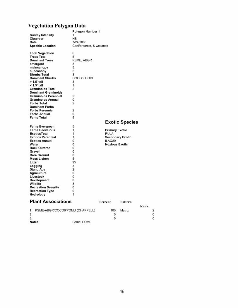
Vegetation Polygon Data Polygon Number 1 Survey Intensity 1 Observer HS Date 7/24/2006 Specific Location Conifer forest, S wetlands
Total Vegetation 6 Trees Total 5 Dominant Trees PSME, ABGR emergent 3 maincanopy 5 subcanopy 2 Shrubs Total 3 Dominant Shrubs COCO6, HODI > 1.5' tall 3 < 1.5' tall 1 Graminoids Total 2 Dominant Graminoids Graminoids Perennial 2 Graminoids Annual 0 Forbs Total 2 Dominant Forbs Forbs Perennial 2 Forbs Annual 0 Ferns Total 5 Exotic Species Ferns Evergreen 5 Ferns Deciduous 1 Primary Exotic ExoticsTotal 1 RULA Exotics Perennial 1 Secondary Exotic Exotics Annual 0 ILAQ80 Water 0 Noxious Exotic Rock Outcrop 0 Gravel 0 Bare Ground 0 Moss Lichen 5 Litter 95 Logging 3 Stand Age 2 Agriculture 0 Livestock 0 Development 0 Wildlife 3 Recreation Severity 0 Recreation Type 0 Hydrology 1
Plant Associations Percent Pattern Rank 1. PSME-ABGR/COCO6/POMU (CHAPPELL) 100 Matrix 2 2. 0 0 3. 0 0 Notes: Ferns: POMU
47
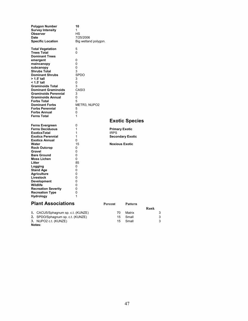
Polygon Number 10 Survey Intensity 1 Observer HS Date 7/25/2006 Specific Location Big wetland polygon.
Total Vegetation 5 Trees Total 0 Dominant Trees emergent 0 maincanopy 0 subcanopy 0 Shrubs Total 3 Dominant Shrubs SPDO > 1.5' tall 3 < 1.5' tall 0 Graminoids Total 3 Dominant Graminoids CASI3 Graminoids Perennial 3 Graminoids Annual 0 Forbs Total 5 Dominant Forbs METR3, NUPO2 Forbs Perennial 5 Forbs Annual 0 Ferns Total 1 Exotic Species Ferns Evergreen 0 Ferns Deciduous 1 Primary Exotic ExoticsTotal 1 IRPS Exotics Perennial 1 Secondary Exotic Exotics Annual 0 Water 15 Noxious Exotic Rock Outcrop 0 Gravel 0 Bare Ground 0 Moss Lichen 0 Litter 85 Logging 0 Stand Age 0 Agriculture 0 Livestock 0 Development 0 Wildlife 0 Recreation Severity 0 Recreation Type 0 Hydrology 1
Plant Associations Percent Pattern Rank 1. CACU5/Sphagnum sp. c.t. (KUNZE) 70 Matrix 3 2. SPDO/Sphagnum sp. c.t. (KUNZE) 15 Small 3 3. NUPO2 c.t. (KUNZE) 15 Small 3 Notes:

48
Polygon Number 11 Survey Intensity 1 Observer Date Specific Location
Total Vegetation 0 Trees Total 0 Dominant Trees emergent 0 maincanopy 0 subcanopy 0 Shrubs Total 0 Dominant Shrubs > 1.5' tall 0 < 1.5' tall 0 Graminoids Total 0 Dominant Graminoids Graminoids Perennial 0 Graminoids Annual 0 Forbs Total 0 Dominant Forbs Forbs Perennial 0 Forbs Annual 0 Ferns Total 0 Exotic Species Ferns Evergreen 0 Ferns Deciduous 0 Primary Exotic ExoticsTotal 0 Exotics Perennial 0 Secondary Exotic Exotics Annual 0 Water 0 Noxious Exotic Rock Outcrop 0 Gravel 0 Bare Ground 0 Moss Lichen 0 Litter 0 Logging Stand Age Agriculture Livestock Development Wildlife Recreation Severity Recreation Type Hydrology
Plant Associations Percent Pattern Rank 1. developed 100 Matrix 1 2. 0 0 3. 0 0 Notes:

49
Polygon Number 12 Survey Intensity 1 Observer Date Specific Location
Total Vegetation 0 Trees Total 0 Dominant Trees emergent 0 maincanopy 0 subcanopy 0 Shrubs Total 0 Dominant Shrubs > 1.5' tall 0 < 1.5' tall 0 Graminoids Total 0 Dominant Graminoids Graminoids Perennial 0 Graminoids Annual 0 Forbs Total 0 Dominant Forbs Forbs Perennial 0 Forbs Annual 0 Ferns Total 0 Exotic Species Ferns Evergreen 0 Ferns Deciduous 0 Primary Exotic ExoticsTotal 0 Exotics Perennial 0 Secondary Exotic Exotics Annual 0 Water 0 Noxious Exotic Rock Outcrop 0 Gravel 0 Bare Ground 0 Moss Lichen 0 Litter 0 Logging Stand Age Agriculture Livestock Development Wildlife Recreation Severity Recreation Type Hydrology
Plant Associations Percent Pattern Rank 1. developed 100 Matrix 1 2. 0 0 3. 0 0 Notes:
50
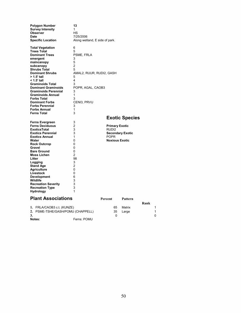
Polygon Number 13 Survey Intensity 1 Observer HS Date 7/25/2006 Specific Location Along wetland, E side of park.
Total Vegetation 6 Trees Total 5 Dominant Trees PSME, FRLA emergent 3 maincanopy 5 subcanopy 2 Shrubs Total 5 Dominant Shrubs AMAL2, RUUR, RUDI2, GASH > 1.5' tall 5 < 1.5' tall 4 Graminoids Total 3 Dominant Graminoids POPR, AGAL, CAOB3 Graminoids Perennial 3 Graminoids Annual 1 Forbs Total 3 Dominant Forbs CENI3, PRVU Forbs Perennial 3 Forbs Annual 1 Ferns Total 3 Exotic Species Ferns Evergreen 3 Ferns Deciduous 2 Primary Exotic ExoticsTotal 3 RUDI2 Exotics Perennial 3 Secondary Exotic Exotics Annual 1 POPR Water 0 Noxious Exotic Rock Outcrop 0 Gravel 0 Bare Ground 0 Moss Lichen 2 Litter 98 Logging 3 Stand Age 2 Agriculture 0 Livestock 0 Development 6 Wildlife 3 Recreation Severity 3 Recreation Type 3 Hydrology 1
Plant Associations Percent Pattern Rank 1. FRLA/CAOB3 c.t. (KUNZE) 65 Matrix 1 2. PSME-TSHE/GASH/POMU (CHAPPELL) 35 Large 1 3. 0 0 Notes: Ferns: POMU

51
Polygon Number 15 Survey Intensity 1 Observer HS Date 7/24/2006 Specific Location Just W of visitor's center.
Total Vegetation 6 Trees Total 6 Dominant Trees PSME, ABGR, FRLA emergent 3 maincanopy 5 subcanopy 3 Shrubs Total 5 Dominant Shrubs COCO6, VAPA, MANE2, GASH > 1.5' tall 5 < 1.5' tall 3 Graminoids Total 2 Dominant Graminoids Graminoids Perennial 2 Graminoids Annual 0 Forbs Total 1 Dominant Forbs Forbs Perennial 1 Forbs Annual 0 Ferns Total 3 Exotic Species Ferns Evergreen 3 Ferns Deciduous 1 Primary Exotic ExoticsTotal 2 HEHE Exotics Perennial 2 Secondary Exotic Exotics Annual 0 ILAQ80 Water 0 Noxious Exotic Rock Outcrop 0 Gravel 0 Bare Ground 0 Moss Lichen 5 Litter 95 Logging 3 Stand Age 2 Agriculture 0 Livestock 0 Development 0 Wildlife 3 Recreation Severity 0 Recreation Type 0 Hydrology 1
Plant Associations Percent Pattern Rank 1. PSME-ABGR/COCO6/POMU (CHAPPELL) 80 Matrix 2 2. FRLA/CAOB3 c.t. (KUNZE) 20 Small 2 3. 0 0 Notes: Ferns: POMU
52
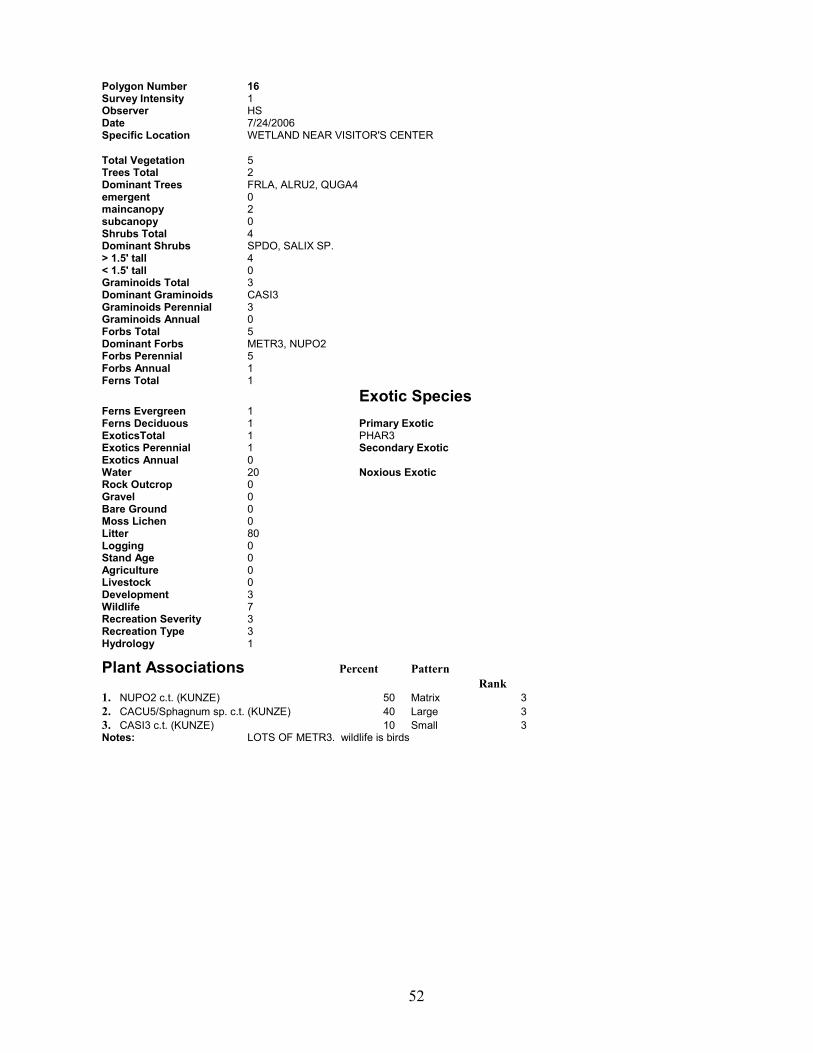
Polygon Number 16 Survey Intensity 1 Observer HS Date 7/24/2006 Specific Location WETLAND NEAR VISITOR'S CENTER
Total Vegetation 5 Trees Total 2 Dominant Trees FRLA, ALRU2, QUGA4 emergent 0 maincanopy 2 subcanopy 0 Shrubs Total 4 Dominant Shrubs SPDO, SALIX SP. > 1.5' tall 4 < 1.5' tall 0 Graminoids Total 3 Dominant Graminoids CASI3 Graminoids Perennial 3 Graminoids Annual 0 Forbs Total 5 Dominant Forbs METR3, NUPO2 Forbs Perennial 5 Forbs Annual 1 Ferns Total 1 Exotic Species Ferns Evergreen 1 Ferns Deciduous 1 Primary Exotic ExoticsTotal 1 PHAR3 Exotics Perennial 1 Secondary Exotic Exotics Annual 0 Water 20 Noxious Exotic Rock Outcrop 0 Gravel 0 Bare Ground 0 Moss Lichen 0 Litter 80 Logging 0 Stand Age 0 Agriculture 0 Livestock 0 Development 3 Wildlife 7 Recreation Severity 3 Recreation Type 3 Hydrology 1
Plant Associations Percent Pattern Rank 1. NUPO2 c.t. (KUNZE) 50 Matrix 3 2. CACU5/Sphagnum sp. c.t. (KUNZE) 40 Large 3 3. CASI3 c.t. (KUNZE) 10 Small 3 Notes: LOTS OF METR3. wildlife is birds

53
Polygon Number 18 Survey Intensity 1 Observer Date Specific Location
Total Vegetation 0 Trees Total 0 Dominant Trees emergent 0 maincanopy 0 subcanopy 0 Shrubs Total 0 Dominant Shrubs > 1.5' tall 0 < 1.5' tall 0 Graminoids Total 0 Dominant Graminoids Graminoids Perennial 0 Graminoids Annual 0 Forbs Total 0 Dominant Forbs Forbs Perennial 0 Forbs Annual 0 Ferns Total 0 Exotic Species Ferns Evergreen 0 Ferns Deciduous 0 Primary Exotic ExoticsTotal 0 Exotics Perennial 0 Secondary Exotic Exotics Annual 0 Water 0 Noxious Exotic Rock Outcrop 0 Gravel 0 Bare Ground 0 Moss Lichen 0 Litter 0 Logging Stand Age Agriculture Livestock Development Wildlife Recreation Severity Recreation Type Hydrology
Plant Associations Percent Pattern Rank 1. developed 100 Matrix 1 2. 0 0 3. 0 0 Notes:
54
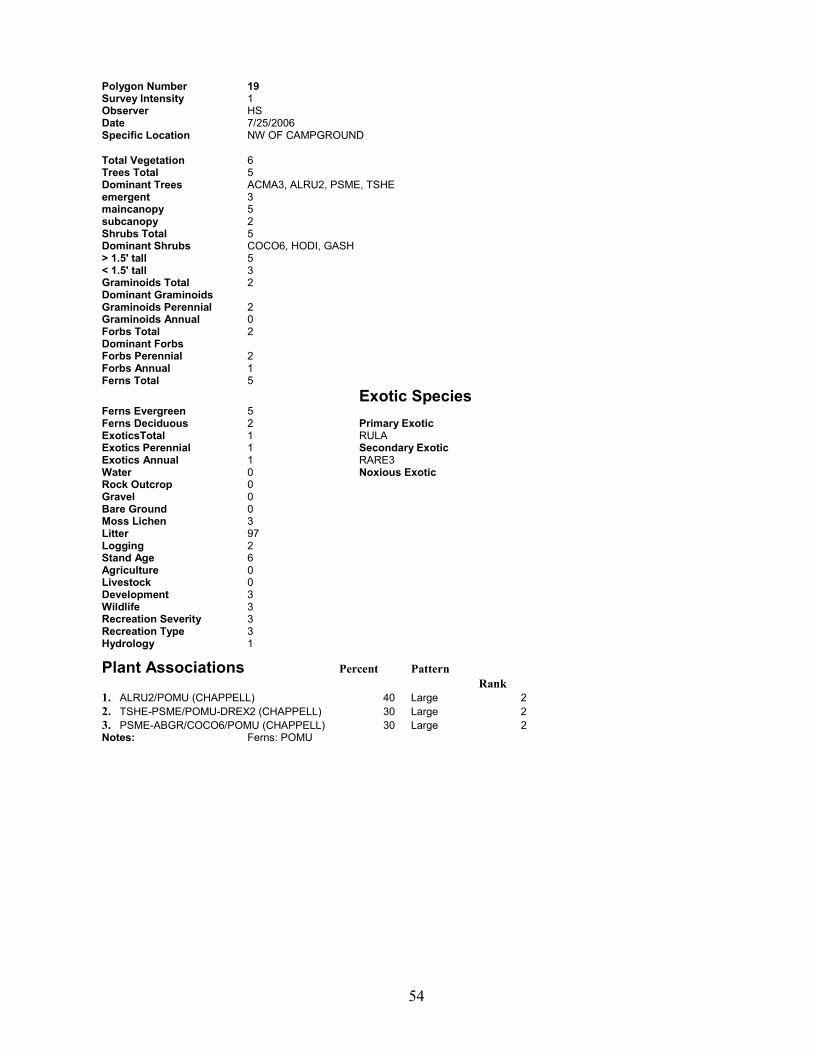
Polygon Number 19 Survey Intensity 1 Observer HS Date 7/25/2006 Specific Location NW OF CAMPGROUND
Total Vegetation 6 Trees Total 5 Dominant Trees ACMA3, ALRU2, PSME, TSHE emergent 3 maincanopy 5 subcanopy 2 Shrubs Total 5 Dominant Shrubs COCO6, HODI, GASH > 1.5' tall 5 < 1.5' tall 3 Graminoids Total 2 Dominant Graminoids Graminoids Perennial 2 Graminoids Annual 0 Forbs Total 2 Dominant Forbs Forbs Perennial 2 Forbs Annual 1 Ferns Total 5 Exotic Species Ferns Evergreen 5 Ferns Deciduous 2 Primary Exotic ExoticsTotal 1 RULA Exotics Perennial 1 Secondary Exotic Exotics Annual 1 RARE3 Water 0 Noxious Exotic Rock Outcrop 0 Gravel 0 Bare Ground 0 Moss Lichen 3 Litter 97 Logging 2 Stand Age 6 Agriculture 0 Livestock 0 Development 3 Wildlife 3 Recreation Severity 3 Recreation Type 3 Hydrology 1
Plant Associations Percent Pattern Rank 1. ALRU2/POMU (CHAPPELL) 40 Large 2 2. TSHE-PSME/POMU-DREX2 (CHAPPELL) 30 Large 2 3. PSME-ABGR/COCO6/POMU (CHAPPELL) 30 Large 2 Notes: Ferns: POMU

55
Polygon Number 2 Survey Intensity 1 Observer hs Date 7/24/2006 Specific Location S wetlands
Total Vegetation 6 Trees Total 6 Dominant Trees ALRU2, ACMA3, PSME, ABGR, TSHE, THPL emergent 2 maincanopy 6 subcanopy 2 Shrubs Total 4 Dominant Shrubs COCO6, ACCI > 1.5' tall 4 < 1.5' tall 2 Graminoids Total 3 Dominant Graminoids BRVU Graminoids Perennial 3 Graminoids Annual 0 Forbs Total 3 Dominant Forbs MOSI2 Forbs Perennial 3 Forbs Annual 0 Ferns Total 5 Exotic Species Ferns Evergreen 5 Ferns Deciduous 2 Primary Exotic ExoticsTotal 1 ILAQ80 Exotics Perennial 1 Secondary Exotic Exotics Annual 0 Water 0 Noxious Exotic Rock Outcrop 0 Gravel 0 Bare Ground 0 Moss Lichen 3 Litter 97 Logging 3 Stand Age 2 Agriculture 0 Livestock 0 Development 0 Wildlife 3 Recreation Severity 0 Recreation Type 0 Hydrology 1
Plant Associations Percent Pattern Rank 1. ALRU2/POMU (CHAPPELL) 55 Matrix 2 2. TSHE-PSME/POMU-DREX2 (CHAPPELL) 40 Large 2 3. Salix sp. c.t. (KUNZE) 5 Small 2 Notes: Ferns: POMU
56
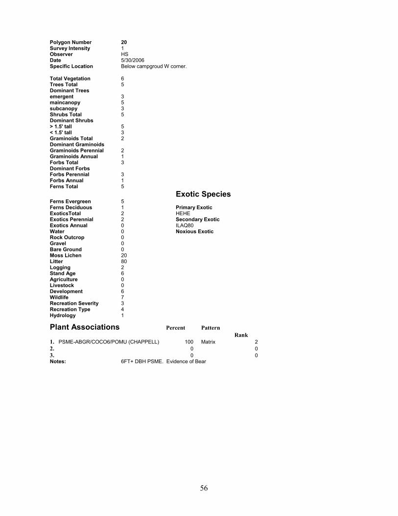
Polygon Number 20 Survey Intensity 1 Observer HS Date 5/30/2006 Specific Location Below campgroud W corner.
Total Vegetation 6 Trees Total 5 Dominant Trees emergent 3 maincanopy 5 subcanopy 3 Shrubs Total 5 Dominant Shrubs > 1.5' tall 5 < 1.5' tall 3 Graminoids Total 2 Dominant Graminoids Graminoids Perennial 2 Graminoids Annual 1 Forbs Total 3 Dominant Forbs Forbs Perennial 3 Forbs Annual 1 Ferns Total 5 Exotic Species Ferns Evergreen 5 Ferns Deciduous 1 Primary Exotic ExoticsTotal 2 HEHE Exotics Perennial 2 Secondary Exotic Exotics Annual 0 ILAQ80 Water 0 Noxious Exotic Rock Outcrop 0 Gravel 0 Bare Ground 0 Moss Lichen 20 Litter 80 Logging 2 Stand Age 6 Agriculture 0 Livestock 0 Development 6 Wildlife 7 Recreation Severity 3 Recreation Type 4 Hydrology 1
Plant Associations Percent Pattern Rank 1. PSME-ABGR/COCO6/POMU (CHAPPELL) 100 Matrix 2 2. 0 0 3. 0 0 Notes: 6FT+ DBH PSME. Evidence of Bear

57
Polygon Number 21 Survey Intensity 1 Observer HS Date 5/31/2006 Specific Location SE corner N of road.
Total Vegetation 6 Trees Total 6 Dominant Trees PSME, ABGR, THPL, TSHE, ACMA3 emergent 2 maincanopy 5 subcanopy 2 Shrubs Total 5 Dominant Shrubs GASH, MANE2, COCO6, ACCI > 1.5' tall 5 < 1.5' tall 3 Graminoids Total 1 Dominant Graminoids Graminoids Perennial 1 Graminoids Annual 0 Forbs Total 2 Dominant Forbs POMU Forbs Perennial 2 Forbs Annual 1 Ferns Total 4 Exotic Species Ferns Evergreen 4 Ferns Deciduous 2 Primary Exotic ExoticsTotal 2 HEHE Exotics Perennial 2 Secondary Exotic Exotics Annual 0 Water 0 Noxious Exotic Rock Outcrop 0 Gravel 0 Bare Ground 0 Moss Lichen 5 Litter 95 Logging 3 Stand Age 5 Agriculture 0 Livestock 0 Development 3 Wildlife 7 Recreation Severity 3 Recreation Type 3 Hydrology 1
Plant Associations Percent Pattern Rank 1. PSME-TSHE/GASH/POMU (CHAPPELL) 80 Matrix 2 2. PSME-ABGR/COCO6/POMU (CHAPPELL) 20 Large 2 3. 0 0 Notes: wildlife is birds

58
Polygon Number 23 Survey Intensity 1 Observer HS Date 5/31/2006 Specific Location NE of camping areas.
Total Vegetation 6 Trees Total 5 Dominant Trees PSME, ABGR, TSHE, ACMA3 emergent 3 maincanopy 5 subcanopy 2 Shrubs Total 5 Dominant Shrubs GASH, COCO6, MANE2, VAPA > 1.5' tall 5 < 1.5' tall 3 Graminoids Total 2 Dominant Graminoids Graminoids Perennial 2 Graminoids Annual 1 Forbs Total 3 Dominant Forbs POMU Forbs Perennial 3 Forbs Annual 1 Ferns Total 5 Exotic Species Ferns Evergreen 5 Ferns Deciduous 2 Primary Exotic ExoticsTotal 1 HEHE Exotics Perennial 1 Secondary Exotic Exotics Annual 0 ILAQ80 Water 0 Noxious Exotic Rock Outcrop 0 Gravel 0 Bare Ground 0 Moss Lichen 4 Litter 96 Logging 2 Stand Age 6 Agriculture 0 Livestock 0 Development 3 Wildlife 7 Recreation Severity 3 Recreation Type 3 Hydrology 1
Plant Associations Percent Pattern Rank 1. PSME-TSHE/GASH/POMU (CHAPPELL) 58 Matrix 2 2. PSME-ABGR/COCO6/POMU (CHAPPELL) 37 Large 2 3. ALRU2/RUSP c.t. (KUNZE) 5 Small 2 Notes: wildlife is birds, bear

59
Polygon Number 23B Survey Intensity 1 Observer HS Date 7/25/2006 Specific Location E SIDE OF PARK, BEHIND RANGER STATION
Total Vegetation 6 Trees Total 5 Dominant Trees PSME, ABGR, ACMA3 emergent 3 maincanopy 5 subcanopy 3 Shrubs Total 5 Dominant Shrubs COCO6, GASH, ACCI > 1.5' tall 5 < 1.5' tall 3 Graminoids Total 1 Dominant Graminoids Graminoids Perennial 1 Graminoids Annual 0 Forbs Total 2 Dominant Forbs Forbs Perennial 2 Forbs Annual 0 Ferns Total 4 Exotic Species Ferns Evergreen 4 Ferns Deciduous 2 Primary Exotic ExoticsTotal 2 HEHE Exotics Perennial 2 Secondary Exotic Exotics Annual 0 SOAU Water 0 Noxious Exotic Rock Outcrop 0 Gravel 0 Bare Ground 0 Moss Lichen 5 Litter 95 Logging 2 Stand Age 6 Agriculture 0 Livestock 0 Development 3 Wildlife 3 Recreation Severity 3 Recreation Type 3 Hydrology 1
Plant Associations Percent Pattern Rank 1. PSME-ABGR/COCO6/POMU (CHAPPELL) 100 Matrix 2 2. 0 0 3. 0 0 Notes: Ferns: POMU. Ivy infestation!

60
Polygon Number 24 Survey Intensity 1 Observer HS Date 5/31/2006 Specific Location W side of park.
Total Vegetation 6 Trees Total 6 Dominant Trees PSME, ABGR, ACMA3 emergent 3 maincanopy 5 subcanopy 2 Shrubs Total 5 Dominant Shrubs COCO6, GASH, MANE2, SYAL > 1.5' tall 5 < 1.5' tall 2 Graminoids Total 1 Dominant Graminoids Graminoids Perennial 1 Graminoids Annual 0 Forbs Total 2 Dominant Forbs POMU Forbs Perennial 2 Forbs Annual 1 Ferns Total 5 Exotic Species Ferns Evergreen 5 Ferns Deciduous 2 Primary Exotic ExoticsTotal 1 ILAQ80 Exotics Perennial 1 Secondary Exotic Exotics Annual 0 VIMA Water 0 Noxious Exotic Rock Outcrop 0 Gravel 0 Bare Ground 0 Moss Lichen 3 Litter 97 Logging 2 Stand Age 6 Agriculture 0 Livestock 0 Development 6 Wildlife 7 Recreation Severity 3 Recreation Type 4 Hydrology 2
Plant Associations Percent Pattern Rank 1. PSME-ABGR/COCO6/POMU (CHAPPELL) 70 Matrix 2 2. PSME-TSHE/GASH/POMU (CHAPPELL) 30 Small 2 3. 0 0 Notes: wildlife is birds

61
Polygon Number 25 Survey Intensity 1 Observer HS Date 5/31/2006 Specific Location N of Sewage Lagoon
Total Vegetation 6 Trees Total 5 Dominant Trees PSME emergent 1 maincanopy 5 subcanopy 1 Shrubs Total 6 Dominant Shrubs GASH, COCO6, HODI > 1.5' tall 6 < 1.5' tall 2 Graminoids Total 1 Dominant Graminoids Graminoids Perennial 1 Graminoids Annual 0 Forbs Total 2 Dominant Forbs PTAQ Forbs Perennial 2 Forbs Annual 1 Ferns Total 3 Exotic Species Ferns Evergreen 1 Ferns Deciduous 3 Primary Exotic ExoticsTotal 1 ILAQ80 Exotics Perennial 1 Secondary Exotic Exotics Annual 0 Water 0 Noxious Exotic Rock Outcrop 0 Gravel 0 Bare Ground 0 Moss Lichen 3 Litter 97 Logging 3 Stand Age 1 Agriculture 0 Livestock 0 Development 6 Wildlife 0 Recreation Severity 0 Recreation Type 3 Hydrology 2
Plant Associations Percent Pattern Rank 1. Mixed Shrub Undescribed (CHAPPELL) 60 Matrix 1 2. PSME-TSHE/GASH/POMU (CHAPPELL) 40 Large 2 3. 0 0 Notes:
62
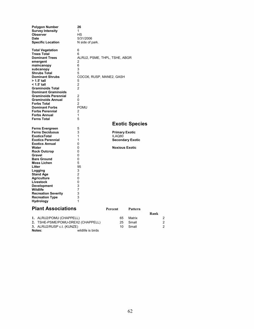
Polygon Number 26 Survey Intensity 1 Observer HS Date 5/31/2006 Specific Location N side of park.
Total Vegetation 6 Trees Total 6 Dominant Trees ALRU2, PSME, THPL, TSHE, ABGR emergent 2 maincanopy 6 subcanopy 3 Shrubs Total 5 Dominant Shrubs COCO6, RUSP, MANE2, GASH > 1.5' tall 5 < 1.5' tall 2 Graminoids Total 2 Dominant Graminoids Graminoids Perennial 2 Graminoids Annual 0 Forbs Total 2 Dominant Forbs POMU Forbs Perennial 2 Forbs Annual 1 Ferns Total 5 Exotic Species Ferns Evergreen 5 Ferns Deciduous 3 Primary Exotic ExoticsTotal 1 ILAQ80 Exotics Perennial 1 Secondary Exotic Exotics Annual 0 Water 0 Noxious Exotic Rock Outcrop 0 Gravel 0 Bare Ground 0 Moss Lichen 5 Litter 95 Logging 3 Stand Age 2 Agriculture 0 Livestock 0 Development 3 Wildlife 7 Recreation Severity 3 Recreation Type 3 Hydrology 1
Plant Associations Percent Pattern Rank 1. ALRU2/POMU (CHAPPELL) 65 Matrix 2 2. TSHE-PSME/POMU-DREX2 (CHAPPELL) 25 Small 2 3. ALRU2/RUSP c.t. (KUNZE) 10 Small 2 Notes: wildlife is birds
63
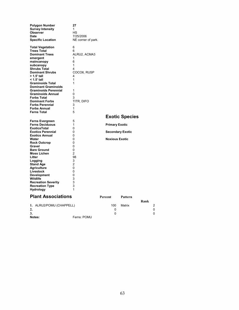
Polygon Number 27 Survey Intensity 1 Observer HS Date 7/25/2006 Specific Location NE corner of park.
Total Vegetation 6 Trees Total 6 Dominant Trees ALRU2, ACMA3 emergent 1 maincanopy 6 subcanopy 1 Shrubs Total 4 Dominant Shrubs COCO6, RUSP > 1.5' tall 4 < 1.5' tall 1 Graminoids Total 1 Dominant Graminoids Graminoids Perennial 1 Graminoids Annual 0 Forbs Total 3 Dominant Forbs TITR, DIFO Forbs Perennial 3 Forbs Annual 1 Ferns Total 5 Exotic Species Ferns Evergreen 5 Ferns Deciduous 1 Primary Exotic ExoticsTotal 0 Exotics Perennial 0 Secondary Exotic Exotics Annual 0 Water 0 Noxious Exotic Rock Outcrop 0 Gravel 0 Bare Ground 0 Moss Lichen 2 Litter 98 Logging 3 Stand Age 2 Agriculture 0 Livestock 0 Development 0 Wildlife 3 Recreation Severity 3 Recreation Type 3 Hydrology 1
Plant Associations Percent Pattern Rank 1. ALRU2/POMU (CHAPPELL) 100 Matrix 2 2. 0 0 3. 0 0 Notes: Ferns: POMU

64
Polygon Number 28 Survey Intensity 1 Observer HS Date 7/25/2006 Specific Location N boundary of park.
Total Vegetation 6 Trees Total 6 Dominant Trees PSME, THPL, ALRU2, TSHE emergent 2 maincanopy 5 subcanopy 3 Shrubs Total 5 Dominant Shrubs ACCI, RUSP > 1.5' tall 5 < 1.5' tall 2 Graminoids Total 1 Dominant Graminoids Graminoids Perennial 1 Graminoids Annual 0 Forbs Total 3 Dominant Forbs TITR, TOME Forbs Perennial 3 Forbs Annual 1 Ferns Total 5 Exotic Species Ferns Evergreen 5 Ferns Deciduous 2 Primary Exotic ExoticsTotal 1 ILAQ80 Exotics Perennial 1 Secondary Exotic Exotics Annual 0 Water 0 Noxious Exotic Rock Outcrop 0 Gravel 0 Bare Ground 0 Moss Lichen 5 Litter 95 Logging 2 Stand Age 3 Agriculture 0 Livestock 0 Development 3 Wildlife 3 Recreation Severity 3 Recreation Type 3 Hydrology 1
Plant Associations Percent Pattern Rank 1. TSHE-PSME/POMU-DREX2 (CHAPPELL) 80 Matrix 2 2. ALRU2/POMU (CHAPPELL) 20 other 2 3. 0 0 Notes: Ferns: POMU
65
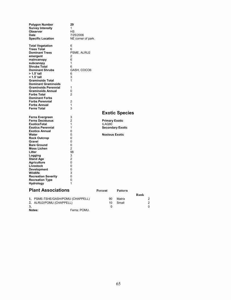
Polygon Number 29 Survey Intensity 1 Observer HS Date 7/25/2006 Specific Location NE corner of park.
Total Vegetation 6 Trees Total 6 Dominant Trees PSME, ALRU2 emergent 2 maincanopy 6 subcanopy 1 Shrubs Total 6 Dominant Shrubs GASH, COCO6 > 1.5' tall 6 < 1.5' tall 3 Graminoids Total 1 Dominant Graminoids Graminoids Perennial 1 Graminoids Annual 0 Forbs Total 2 Dominant Forbs Forbs Perennial 2 Forbs Annual 1 Ferns Total 3 Exotic Species Ferns Evergreen 3 Ferns Deciduous 2 Primary Exotic ExoticsTotal 1 ILAQ80 Exotics Perennial 1 Secondary Exotic Exotics Annual 0 Water 0 Noxious Exotic Rock Outcrop 0 Gravel 0 Bare Ground 0 Moss Lichen 2 Litter 98 Logging 3 Stand Age 2 Agriculture 0 Livestock 0 Development 0 Wildlife 3 Recreation Severity 0 Recreation Type 0 Hydrology 1
Plant Associations Percent Pattern Rank 1. PSME-TSHE/GASH/POMU (CHAPPELL) 90 Matrix 2 2. ALRU2/POMU (CHAPPELL) 10 Small 2 3. 0 0 Notes: Ferns: POMU.

66
Polygon Number 3 Survey Intensity 1 Observer HS Date 7/24/2006 Specific Location S wetlands
Total Vegetation 6 Trees Total 4 Dominant Trees ALRU2, ABGR, FRLA emergent 2 maincanopy 4 subcanopy 1 Shrubs Total 5 Dominant Shrubs SPDO > 1.5' tall 5 < 1.5' tall 1 Graminoids Total 4 Dominant Graminoids CAOB3 Graminoids Perennial 4 Graminoids Annual 0 Forbs Total 2 Dominant Forbs Forbs Perennial 2 Forbs Annual 0 Ferns Total 1 Exotic Species Ferns Evergreen 1 Ferns Deciduous 1 Primary Exotic ExoticsTotal 1 RULA Exotics Perennial 1 Secondary Exotic Exotics Annual 0 Water 0 Noxious Exotic Rock Outcrop 0 Gravel 0 Bare Ground 0 Moss Lichen 0 Litter 100 Logging 3 Stand Age 2 Agriculture 0 Livestock 0 Development 0 Wildlife 3 Recreation Severity 0 Recreation Type 0 Hydrology 1
Plant Associations Percent Pattern Rank 1. SPDO c.t. (KUNZE) 50 Large 2 2. FRLA/CAOB3 c.t. (KUNZE) 50 Large 2 3. 0 0 Notes: Margins of island, seasonally flooded.
67
Polygon Number 30 Survey Intensity 1 Observer HS Date 7/25/2006 Specific Location W SIDE OF PARK.
Total Vegetation 0 Trees Total 0 Dominant Trees emergent 0 maincanopy 0 subcanopy 0 Shrubs Total 0 Dominant Shrubs > 1.5' tall 0 < 1.5' tall 0 Graminoids Total 0 Dominant Graminoids Graminoids Perennial 0 Graminoids Annual 0 Forbs Total 0 Dominant Forbs Forbs Perennial 0 Forbs Annual 0 Ferns Total 0 Exotic Species Ferns Evergreen 0 Ferns Deciduous 0 Primary Exotic ExoticsTotal 0 Exotics Perennial 0 Secondary Exotic Exotics Annual 0 Water 0 Noxious Exotic Rock Outcrop 0 Gravel 0 Bare Ground 0 Moss Lichen 0 Litter 0 Logging Stand Age Agriculture Livestock Development Wildlife Recreation Severity Recreation Type Hydrology
Plant Associations Percent Pattern Rank 1. developed 100 Matrix 1 2. 0 0 3. 0 0 Notes: DISTURBED. WEEDY FIELDS (HOMESTEAD? BURN?) POPR, RULA, CIAR, AGAL.
68
Polygon Number 31 Survey Intensity 1 Observer HS Date 7/25/2006 Specific Location E SIDE OF PARK
Total Vegetation 6 Trees Total 3 Dominant Trees PSME, ACMA3, FRLA emergent 1 maincanopy 3 subcanopy 1 Shrubs Total 6 Dominant Shrubs RUSP, COCO6, SARA2 > 1.5' tall 6 < 1.5' tall 2 Graminoids Total 2 Dominant Graminoids Graminoids Perennial 2 Graminoids Annual 0 Forbs Total 4 Dominant Forbs TITR, OESA Forbs Perennial 4 Forbs Annual 1 Ferns Total 3 Exotic Species Ferns Evergreen 3 Ferns Deciduous 3 Primary Exotic ExoticsTotal 1 RARE3 Exotics Perennial 1 Secondary Exotic Exotics Annual 0 Water 0 Noxious Exotic Rock Outcrop 0 Gravel 0 Bare Ground 0 Moss Lichen 10 Litter 90 Logging 1 Stand Age 3 Agriculture 0 Livestock 0 Development 3 Wildlife 3 Recreation Severity 3 Recreation Type 3 Hydrology 1
Plant Associations Percent Pattern Rank 1. ALRU2/RUSP c.t. (KUNZE) 80 Matrix 2 2. TSHE-PSME/POMU-DREX2 (CHAPPELL) 20 Small 3 3. 0 0 Notes: Ferns: POMU, ATFI

69
Polygon Number 32 Survey Intensity 1 Observer HS Date 7/25/2006 Specific Location E side of park.
Total Vegetation 6 Trees Total 6 Dominant Trees ALRU2 emergent 1 maincanopy 6 subcanopy 1 Shrubs Total 5 Dominant Shrubs COCO6, RUUR > 1.5' tall 5 < 1.5' tall 3 Graminoids Total 1 Dominant Graminoids Graminoids Perennial 1 Graminoids Annual 0 Forbs Total 1 Dominant Forbs Forbs Perennial 1 Forbs Annual 0 Ferns Total 5 Exotic Species Ferns Evergreen 5 Ferns Deciduous 2 Primary Exotic ExoticsTotal 1 ILAQ80 Exotics Perennial 1 Secondary Exotic Exotics Annual 0 Water 0 Noxious Exotic Rock Outcrop 0 Gravel 0 Bare Ground 0 Moss Lichen 3 Litter 97 Logging 3 Stand Age 2 Agriculture 0 Livestock 0 Development 3 Wildlife 3 Recreation Severity 3 Recreation Type 3 Hydrology 1
Plant Associations Percent Pattern Rank 1. ALRU2/POMU (CHAPPELL) 100 Matrix 2 2. 0 0 3. 0 0 Notes: Ferns: POMU.
70
Polygon Number 33 Survey Intensity 1 Observer HS Date 5/31/2006 Specific Location E side of park.
Total Vegetation 6 Trees Total 6 Dominant Trees PSME, TSHE, ALRU2 emergent 1 maincanopy 6 subcanopy 2 Shrubs Total 4 Dominant Shrubs COCO6, MANE2 > 1.5' tall 4 < 1.5' tall 2 Graminoids Total 1 Dominant Graminoids Graminoids Perennial 1 Graminoids Annual 0 Forbs Total 2 Dominant Forbs POMU Forbs Perennial 2 Forbs Annual 1 Ferns Total 5 Exotic Species Ferns Evergreen 5 Ferns Deciduous 2 Primary Exotic ExoticsTotal 2 ILAQ80 Exotics Perennial 2 Secondary Exotic Exotics Annual 0 HEHE Water 0 Noxious Exotic Rock Outcrop 0 Gravel 0 Bare Ground 0 Moss Lichen 2 Litter 98 Logging 3 Stand Age 2 Agriculture 0 Livestock 0 Development 3 Wildlife 7 Recreation Severity 3 Recreation Type 3 Hydrology 1
Plant Associations Percent Pattern Rank 1. TSHE-PSME/POMU-DREX2 (CHAPPELL) 50 Matrix 2 2. PSME-TSHE/GASH/POMU (CHAPPELL) 43 Large 2 3. ALRU2/POMU (CHAPPELL) 7 Small 2 Notes: wildlife is birds

71
Polygon Number 33B Survey Intensity 1 Observer HS Date 7/25/2006 Specific Location E side of park.
Total Vegetation 6 Trees Total 6 Dominant Trees PSME, TSHE emergent 2 maincanopy 6 subcanopy 1 Shrubs Total 4 Dominant Shrubs GASH, COCO6, RUUR > 1.5' tall 4 < 1.5' tall 3 Graminoids Total 1 Dominant Graminoids Graminoids Perennial 1 Graminoids Annual 0 Forbs Total 2 Dominant Forbs Forbs Perennial 2 Forbs Annual 0 Ferns Total 5 Exotic Species Ferns Evergreen 5 Ferns Deciduous 2 Primary Exotic ExoticsTotal 1 HEHE Exotics Perennial 1 Secondary Exotic Exotics Annual 0 ILAQ80 Water 0 Noxious Exotic Rock Outcrop 0 Gravel 0 Bare Ground 0 Moss Lichen 5 Litter 95 Logging 3 Stand Age 2 Agriculture 0 Livestock 0 Development 3 Wildlife 3 Recreation Severity 3 Recreation Type 3 Hydrology 1
Plant Associations Percent Pattern Rank 1. PSME-TSHE/GASH/POMU (CHAPPELL) 70 Matrix 2 2. TSHE-PSME/POMU-DREX2 (CHAPPELL) 30 Large 2 3. 0 0 Notes: Ferns: POMU

72
Polygon Number 34 Survey Intensity 1 Observer HS Date 7/25/2006 Specific Location NW corner of park.
Total Vegetation 6 Trees Total 6 Dominant Trees PSME, ABGR emergent 1 maincanopy 6 subcanopy 2 Shrubs Total 5 Dominant Shrubs GASH, COCO6 > 1.5' tall 5 < 1.5' tall 2 Graminoids Total 1 Dominant Graminoids Graminoids Perennial 1 Graminoids Annual 0 Forbs Total 2 Dominant Forbs Forbs Perennial 2 Forbs Annual 0 Ferns Total 3 Exotic Species Ferns Evergreen 3 Ferns Deciduous 1 Primary Exotic ExoticsTotal 0 Exotics Perennial 0 Secondary Exotic Exotics Annual 0 Water 0 Noxious Exotic Rock Outcrop 0 Gravel 0 Bare Ground 0 Moss Lichen 2 Litter 98 Logging 3 Stand Age 2 Agriculture 0 Livestock 0 Development 0 Wildlife 3 Recreation Severity 0 Recreation Type 0 Hydrology 1
Plant Associations Percent Pattern Rank 1. PSME-ABGR/COCO6/POMU (CHAPPELL) 100 Matrix 2 2. 0 0 3. 0 0 Notes: Ferns: POMU

73
Polygon Number 35 Survey Intensity 1 Observer HS Date 5/31/2006 Specific Location W Side, N region of park.
Total Vegetation 6 Trees Total 6 Dominant Trees PSME, ALRU2 emergent 1 maincanopy 6 subcanopy 1 Shrubs Total 3 Dominant Shrubs COCO6, RUUR, GASH > 1.5' tall 3 < 1.5' tall 1 Graminoids Total 1 Dominant Graminoids Graminoids Perennial 1 Graminoids Annual 0 Forbs Total 3 Dominant Forbs POMU Forbs Perennial 3 Forbs Annual 1 Ferns Total 4 Exotic Species Ferns Evergreen 4 Ferns Deciduous 2 Primary Exotic ExoticsTotal 1 ILAQ80 Exotics Perennial 1 Secondary Exotic Exotics Annual 0 Water 0 Noxious Exotic Rock Outcrop 0 Gravel 0 Bare Ground 0 Moss Lichen 5 Litter 95 Logging 3 Stand Age 2 Agriculture 0 Livestock 0 Development 3 Wildlife 7 Recreation Severity 3 Recreation Type 3 Hydrology 1
Plant Associations Percent Pattern Rank 1. TSHE-PSME/POMU-DREX2 (CHAPPELL) 85 Matrix 2 2. ALRU2/POMU (CHAPPELL) 10 Small 2 3. ALRU2/RUSP c.t. (KUNZE) 5 linear 2 Notes: wildlife is birds
74
Polygon Number 36 Survey Intensity 1 Observer HS Date 7/24/2006 Specific Location N OF BIG ISLAND
Total Vegetation 6 Trees Total 0 Dominant Trees emergent 0 maincanopy 0 subcanopy 0 Shrubs Total 4 Dominant Shrubs SPDO > 1.5' tall 4 < 1.5' tall 0 Graminoids Total 4 Dominant Graminoids CASI3 Graminoids Perennial 4 Graminoids Annual 0 Forbs Total 5 Dominant Forbs METR3, NUPO2, POPA14 Forbs Perennial 5 Forbs Annual 1 Ferns Total 1 Exotic Species Ferns Evergreen 0 Ferns Deciduous 1 Primary Exotic ExoticsTotal 2 IRPS Exotics Perennial 2 Secondary Exotic Exotics Annual 0 Water 0 Noxious Exotic Rock Outcrop 0 Gravel 0 Bare Ground 3 Moss Lichen 0 Litter 97 Logging 0 Stand Age 0 Agriculture 0 Livestock 0 Development 0 Wildlife 7 Recreation Severity 0 Recreation Type 0 Hydrology 1
Plant Associations Percent Pattern Rank 1. CACU5/Sphagnum sp. c.t. (KUNZE) 65 Matrix 3 2. SPDO/Sphagnum sp. c.t. (KUNZE) 25 Small 3 3. NUPO2 c.t. (KUNZE) 10 Small 3 Notes: wildlife is birds, beaver
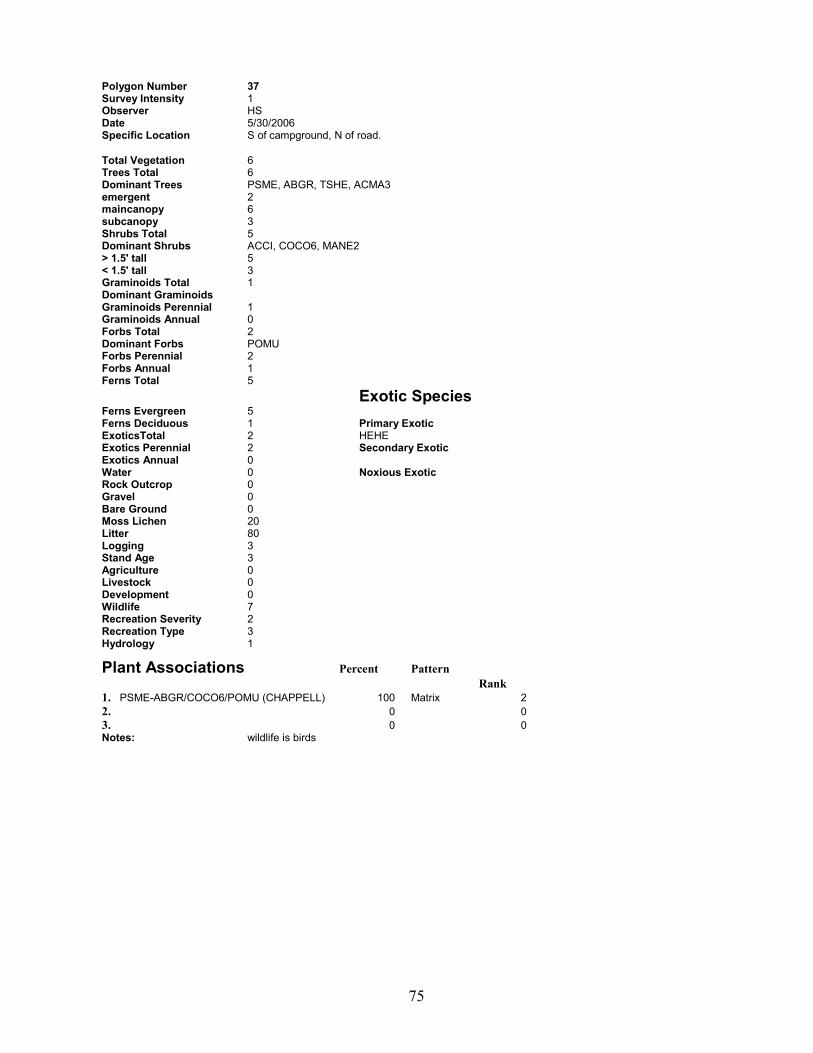
75
Polygon Number 37 Survey Intensity 1 Observer HS Date 5/30/2006 Specific Location S of campground, N of road.
Total Vegetation 6 Trees Total 6 Dominant Trees PSME, ABGR, TSHE, ACMA3 emergent 2 maincanopy 6 subcanopy 3 Shrubs Total 5 Dominant Shrubs ACCI, COCO6, MANE2 > 1.5' tall 5 < 1.5' tall 3 Graminoids Total 1 Dominant Graminoids Graminoids Perennial 1 Graminoids Annual 0 Forbs Total 2 Dominant Forbs POMU Forbs Perennial 2 Forbs Annual 1 Ferns Total 5 Exotic Species Ferns Evergreen 5 Ferns Deciduous 1 Primary Exotic ExoticsTotal 2 HEHE Exotics Perennial 2 Secondary Exotic Exotics Annual 0 Water 0 Noxious Exotic Rock Outcrop 0 Gravel 0 Bare Ground 0 Moss Lichen 20 Litter 80 Logging 3 Stand Age 3 Agriculture 0 Livestock 0 Development 0 Wildlife 7 Recreation Severity 2 Recreation Type 3 Hydrology 1
Plant Associations Percent Pattern Rank 1. PSME-ABGR/COCO6/POMU (CHAPPELL) 100 Matrix 2 2. 0 0 3. 0 0 Notes: wildlife is birds
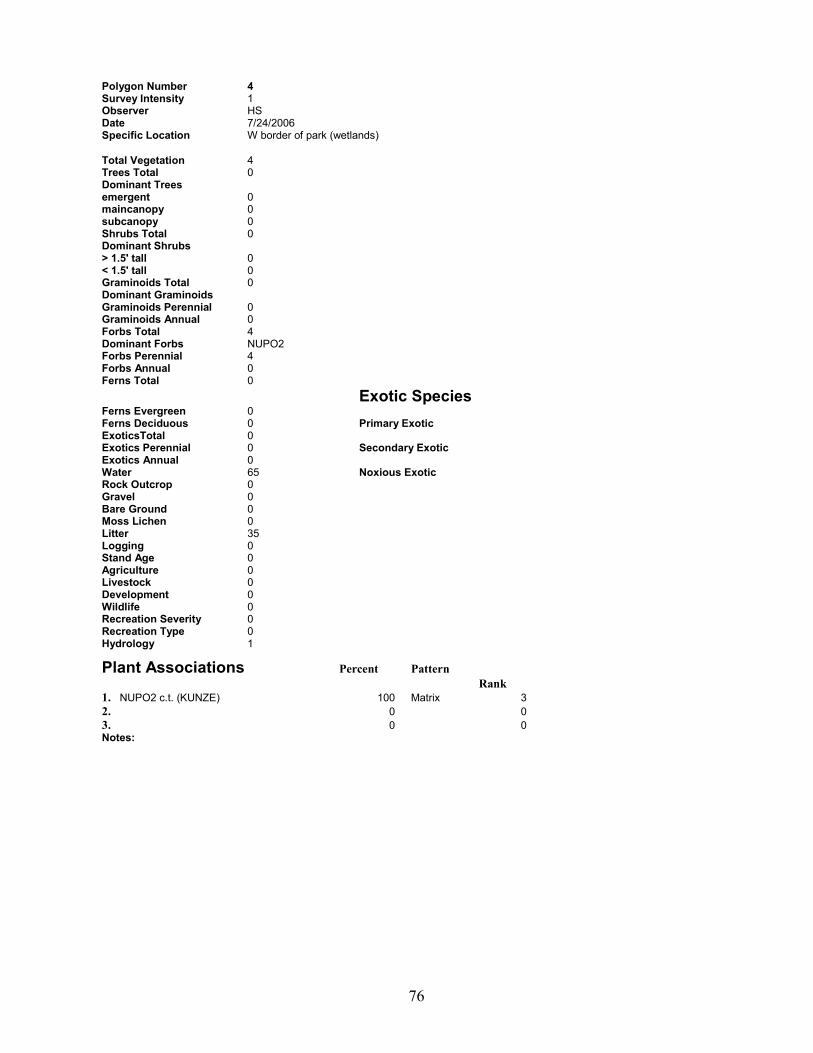
76
Polygon Number 4 Survey Intensity 1 Observer HS Date 7/24/2006 Specific Location W border of park (wetlands)
Total Vegetation 4 Trees Total 0 Dominant Trees emergent 0 maincanopy 0 subcanopy 0 Shrubs Total 0 Dominant Shrubs > 1.5' tall 0 < 1.5' tall 0 Graminoids Total 0 Dominant Graminoids Graminoids Perennial 0 Graminoids Annual 0 Forbs Total 4 Dominant Forbs NUPO2 Forbs Perennial 4 Forbs Annual 0 Ferns Total 0 Exotic Species Ferns Evergreen 0 Ferns Deciduous 0 Primary Exotic ExoticsTotal 0 Exotics Perennial 0 Secondary Exotic Exotics Annual 0 Water 65 Noxious Exotic Rock Outcrop 0 Gravel 0 Bare Ground 0 Moss Lichen 0 Litter 35 Logging 0 Stand Age 0 Agriculture 0 Livestock 0 Development 0 Wildlife 0 Recreation Severity 0 Recreation Type 0 Hydrology 1
Plant Associations Percent Pattern Rank 1. NUPO2 c.t. (KUNZE) 100 Matrix 3 2. 0 0 3. 0 0 Notes:
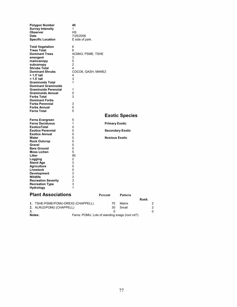
77
Polygon Number 40 Survey Intensity 1 Observer HS Date 7/25/2006 Specific Location E side of park.
Total Vegetation 6 Trees Total 6 Dominant Trees ACMA3, PSME, TSHE emergent 3 maincanopy 5 subcanopy 2 Shrubs Total 4 Dominant Shrubs COCO6, GASH, MANE2 > 1.5' tall 4 < 1.5' tall 3 Graminoids Total 1 Dominant Graminoids Graminoids Perennial 1 Graminoids Annual 0 Forbs Total 3 Dominant Forbs Forbs Perennial 3 Forbs Annual 0 Ferns Total 5 Exotic Species Ferns Evergreen 5 Ferns Deciduous 1 Primary Exotic ExoticsTotal 0 Exotics Perennial 0 Secondary Exotic Exotics Annual 0 Water 0 Noxious Exotic Rock Outcrop 0 Gravel 0 Bare Ground 0 Moss Lichen 5 Litter 95 Logging 2 Stand Age 3 Agriculture 0 Livestock 0 Development 3 Wildlife 3 Recreation Severity 3 Recreation Type 3 Hydrology 1
Plant Associations Percent Pattern Rank 1. TSHE-PSME/POMU-DREX2 (CHAPPELL) 70 Matrix 2 2. ALRU2/POMU (CHAPPELL) 30 Small 2 3. 0 0 Notes: Ferns: POMU. Lots of standing snags (root rot?)
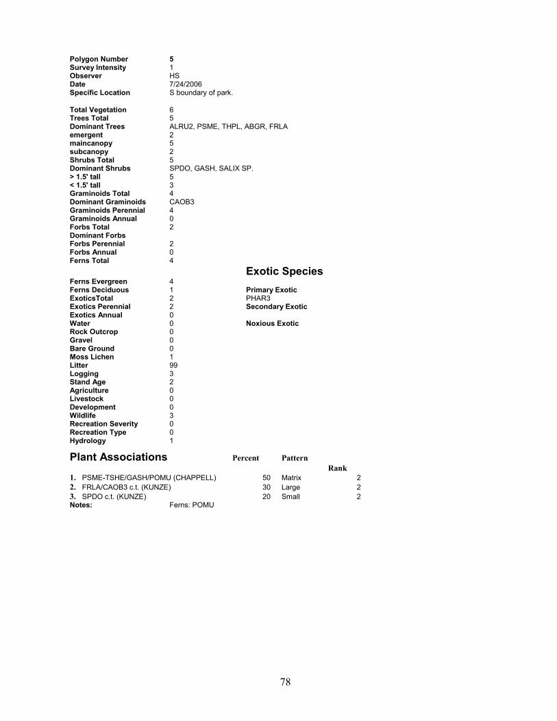
78
Polygon Number 5 Survey Intensity 1 Observer HS Date 7/24/2006 Specific Location S boundary of park.
Total Vegetation 6 Trees Total 5 Dominant Trees ALRU2, PSME, THPL, ABGR, FRLA emergent 2 maincanopy 5 subcanopy 2 Shrubs Total 5 Dominant Shrubs SPDO, GASH, SALIX SP. > 1.5' tall 5 < 1.5' tall 3 Graminoids Total 4 Dominant Graminoids CAOB3 Graminoids Perennial 4 Graminoids Annual 0 Forbs Total 2 Dominant Forbs Forbs Perennial 2 Forbs Annual 0 Ferns Total 4 Exotic Species Ferns Evergreen 4 Ferns Deciduous 1 Primary Exotic ExoticsTotal 2 PHAR3 Exotics Perennial 2 Secondary Exotic Exotics Annual 0 Water 0 Noxious Exotic Rock Outcrop 0 Gravel 0 Bare Ground 0 Moss Lichen 1 Litter 99 Logging 3 Stand Age 2 Agriculture 0 Livestock 0 Development 0 Wildlife 3 Recreation Severity 0 Recreation Type 0 Hydrology 1
Plant Associations Percent Pattern Rank 1. PSME-TSHE/GASH/POMU (CHAPPELL) 50 Matrix 2 2. FRLA/CAOB3 c.t. (KUNZE) 30 Large 2 3. SPDO c.t. (KUNZE) 20 Small 2 Notes: Ferns: POMU

79
Polygon Number 6 Survey Intensity 2 Observer Date Specific Location
Total Vegetation 0 Trees Total 0 Dominant Trees emergent 0 maincanopy 0 subcanopy 0 Shrubs Total 0 Dominant Shrubs > 1.5' tall 0 < 1.5' tall 0 Graminoids Total 0 Dominant Graminoids Graminoids Perennial 0 Graminoids Annual 0 Forbs Total 0 Dominant Forbs Forbs Perennial 0 Forbs Annual 0 Ferns Total 0 Exotic Species Ferns Evergreen 0 Ferns Deciduous 0 Primary Exotic ExoticsTotal 0 Exotics Perennial 0 Secondary Exotic Exotics Annual 0 Water 0 Noxious Exotic Rock Outcrop 0 Gravel 0 Bare Ground 0 Moss Lichen 0 Litter 0 Logging Stand Age Agriculture Livestock Development Wildlife Recreation Severity Recreation Type Hydrology
Plant Associations Percent Pattern Rank 1. Water 100 Matrix 3 2. 0 0 3. 0 0 Notes:
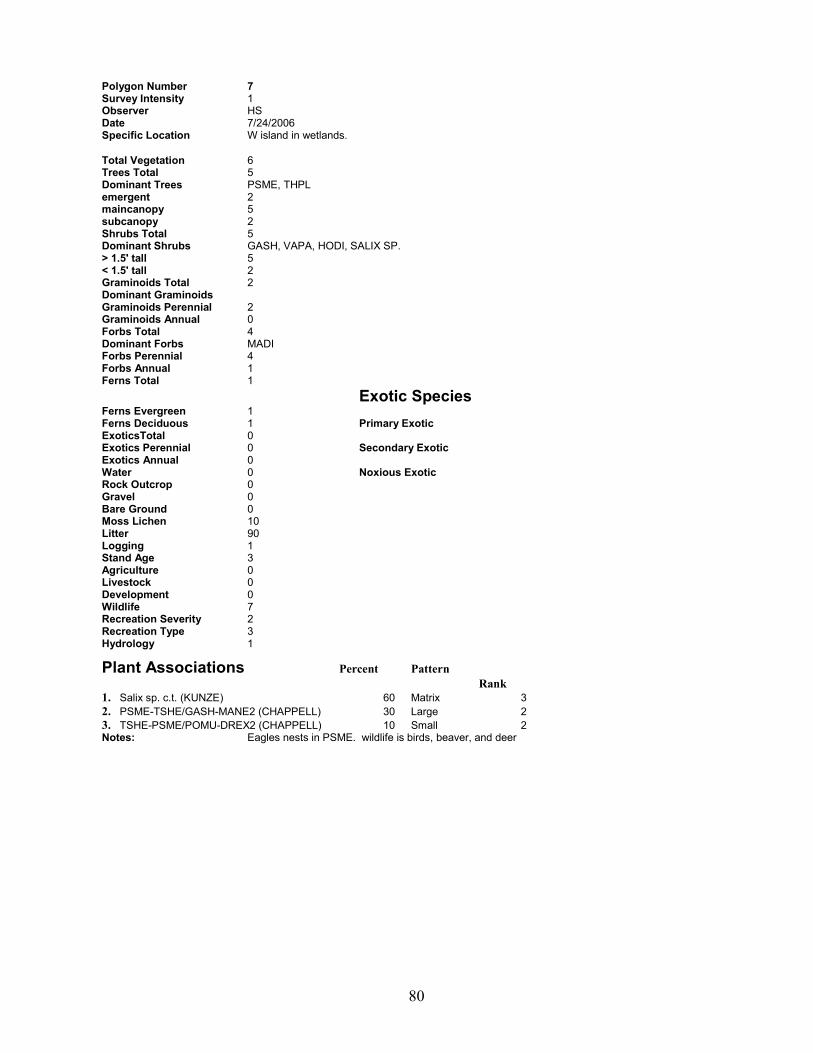
80
Polygon Number 7 Survey Intensity 1 Observer HS Date 7/24/2006 Specific Location W island in wetlands.
Total Vegetation 6 Trees Total 5 Dominant Trees PSME, THPL emergent 2 maincanopy 5 subcanopy 2 Shrubs Total 5 Dominant Shrubs GASH, VAPA, HODI, SALIX SP. > 1.5' tall 5 < 1.5' tall 2 Graminoids Total 2 Dominant Graminoids Graminoids Perennial 2 Graminoids Annual 0 Forbs Total 4 Dominant Forbs MADI Forbs Perennial 4 Forbs Annual 1 Ferns Total 1 Exotic Species Ferns Evergreen 1 Ferns Deciduous 1 Primary Exotic ExoticsTotal 0 Exotics Perennial 0 Secondary Exotic Exotics Annual 0 Water 0 Noxious Exotic Rock Outcrop 0 Gravel 0 Bare Ground 0 Moss Lichen 10 Litter 90 Logging 1 Stand Age 3 Agriculture 0 Livestock 0 Development 0 Wildlife 7 Recreation Severity 2 Recreation Type 3 Hydrology 1
Plant Associations Percent Pattern Rank 1. Salix sp. c.t. (KUNZE) 60 Matrix 3 2. PSME-TSHE/GASH-MANE2 (CHAPPELL) 30 Large 2 3. TSHE-PSME/POMU-DREX2 (CHAPPELL) 10 Small 2 Notes: Eagles nests in PSME. wildlife is birds, beaver, and deer

81
Polygon Number 89 Survey Intensity 1 Observer Date Specific Location
Total Vegetation 0 Trees Total 0 Dominant Trees emergent 0 maincanopy 0 subcanopy 0 Shrubs Total 0 Dominant Shrubs > 1.5' tall 0 < 1.5' tall 0 Graminoids Total 0 Dominant Graminoids Graminoids Perennial 0 Graminoids Annual 0 Forbs Total 0 Dominant Forbs Forbs Perennial 0 Forbs Annual 0 Ferns Total 0 Exotic Species Ferns Evergreen 0 Ferns Deciduous 0 Primary Exotic ExoticsTotal 0 Exotics Perennial 0 Secondary Exotic Exotics Annual 0 Water 0 Noxious Exotic Rock Outcrop 0 Gravel 0 Bare Ground 0 Moss Lichen 0 Litter 0 Logging Stand Age Agriculture Livestock Development Wildlife Recreation Severity Recreation Type Hydrology
Plant Associations Percent Pattern Rank 1. developed 100 Matrix 1 2. 0 0 3. 0 0 Notes:
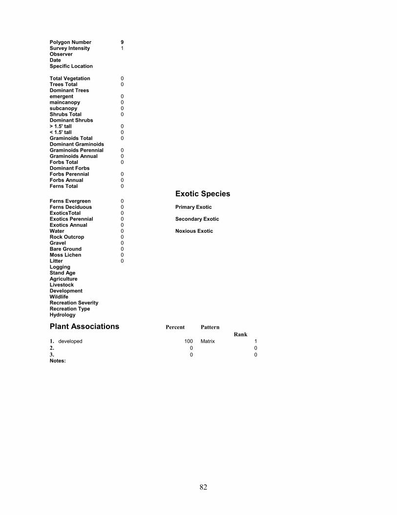
82
Polygon Number 9 Survey Intensity 1 Observer Date Specific Location
Total Vegetation 0 Trees Total 0 Dominant Trees emergent 0 maincanopy 0 subcanopy 0 Shrubs Total 0 Dominant Shrubs > 1.5' tall 0 < 1.5' tall 0 Graminoids Total 0 Dominant Graminoids Graminoids Perennial 0 Graminoids Annual 0 Forbs Total 0 Dominant Forbs Forbs Perennial 0 Forbs Annual 0 Ferns Total 0 Exotic Species Ferns Evergreen 0 Ferns Deciduous 0 Primary Exotic ExoticsTotal 0 Exotics Perennial 0 Secondary Exotic Exotics Annual 0 Water 0 Noxious Exotic Rock Outcrop 0 Gravel 0 Bare Ground 0 Moss Lichen 0 Litter 0 Logging Stand Age Agriculture Livestock Development Wildlife Recreation Severity Recreation Type Hydrology
Plant Associations Percent Pattern Rank 1. developed 100 Matrix 1 2. 0 0 3. 0 0 Notes:
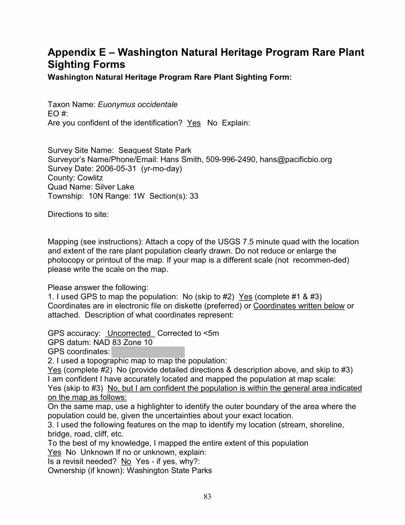
83
Appendix E � Washington Natural Heritage Program Rare Plant Sighting Forms Washington Natural Heritage Program Rare Plant Sighting Form: Taxon Name: Euonymus occidentale EO #: Are you confident of the identification? Yes No Explain: Survey Site Name: Seaquest State Park Surveyor�s Name/Phone/Email: Hans Smith, 509-996-2490, [email protected] Survey Date: 2006-05-31 (yr-mo-day) County: Cowlitz Quad Name: Silver Lake Township: 10N Range: 1W Section(s): 33 Directions to site: Mapping (see instructions): Attach a copy of the USGS 7.5 minute quad with the location and extent of the rare plant population clearly drawn. Do not reduce or enlarge the photocopy or printout of the map. If your map is a different scale (not recommen-ded) please write the scale on the map. Please answer the following: 1. I used GPS to map the population: No (skip to #2) Yes (complete #1 & #3) Coordinates are in electronic file on diskette (preferred) or Coordinates written below or attached. Description of what coordinates represent: GPS accuracy: Uncorrected Corrected to <5m GPS datum: NAD 83 Zone 10 GPS coordinates: 2. I used a topographic map to map the population: Yes (complete #2) No (provide detailed directions & description above, and skip to #3) I am confident I have accurately located and mapped the population at map scale: Yes (skip to #3) No, but I am confident the population is within the general area indicated on the map as follows: On the same map, use a highlighter to identify the outer boundary of the area where the population could be, given the uncertainties about your exact location. 3. I used the following features on the map to identify my location (stream, shoreline, bridge, road, cliff, etc. To the best of my knowledge, I mapped the entire extent of this population Yes No Unknown If no or unknown, explain: Is a revisit needed? No Yes - if yes, why?: Ownership (if known): Washington State Parks

84
Population Size (# of individuals or ramets) or estimate: Approximately 8 plants Population (EO) Data (include population vigor, microhabitat, phenology, etc.): Flat topography, late succesional conifer forest, plants occur along an established trail, population appears healthy, no signs of herbivory or senescence, some plants are flowering. Plant Association: PSME-TSHE/GASH/POMU (Chappell, 2004) Associated Species (include % cover by layer and by individual species for dominants in each layer): Lichen/moss layer: 5% Herb layer: 60% MICA5, POMU, ATFI, Shrub layer(s): 65% COCO6, GASH, MANE2, RUPA Tree layer: 85% PSME, ACMA3 General Description (include description of landscape, surrounding plant communities, land forms, land use, etc.): Flat area along trail with hiking and mountain bike use. Forest is transitioning to late-successional phase. Elevation (ft.): 596 Size (acres): 1/20 Aspect: 0 degrees Slope 2 degrees Photo taken? Yes No Management Comments (exotics, roads, shape/size, position in landscape, hydrology, adjacent land use, cumulative effects, etc.): ILAQ80 is growing nearby � not seemingly a threat. Part of the larger plants are hanging over the trail � they may be accidentally cut during trail maintenance. Off trail hiking could disrupt the population. Protection Comments (legal actions/steps/strategies needed to secure protection for the site): Site is already owned by WA State Parks. Minimize off-trail hiking. Educate any trail maintenance staff/volunteers to identify plant so as not to cut or kill it. Additional Comments (discrepancies, general observations, etc.): Please mail completed form with map: WASHINGTON NATURAL HERITAGE PROGRAM DEPARTMENT OF NATURAL RESOURCES PO BOX 47014, OLYMPIA WA 98504-7014

85
Euonymus occidentale site (red circle)
Rare plant info redacted. Contact Washington State Parks and Recreation Commission for further information.
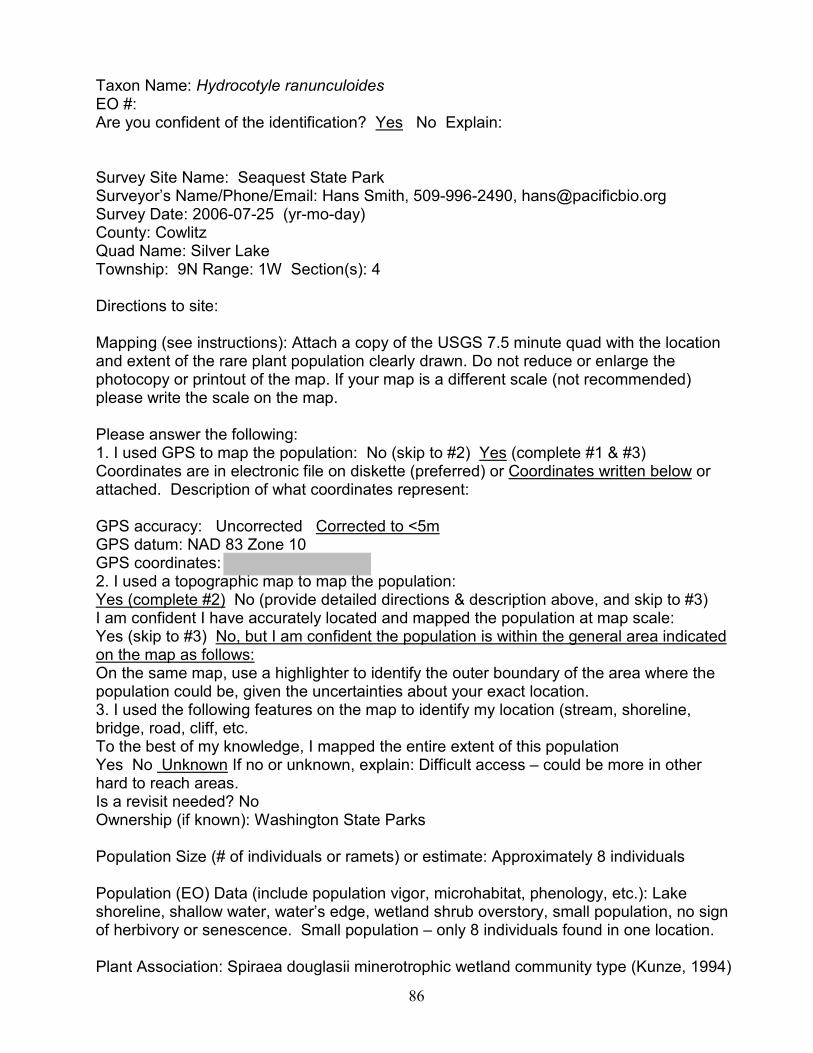
86
Taxon Name: Hydrocotyle ranunculoides EO #: Are you confident of the identification? Yes No Explain: Survey Site Name: Seaquest State Park Surveyor�s Name/Phone/Email: Hans Smith, 509-996-2490, [email protected] Survey Date: 2006-07-25 (yr-mo-day) County: Cowlitz Quad Name: Silver Lake Township: 9N Range: 1W Section(s): 4 Directions to site: Mapping (see instructions): Attach a copy of the USGS 7.5 minute quad with the location and extent of the rare plant population clearly drawn. Do not reduce or enlarge the photocopy or printout of the map. If your map is a different scale (not recommended) please write the scale on the map. Please answer the following: 1. I used GPS to map the population: No (skip to #2) Yes (complete #1 & #3) Coordinates are in electronic file on diskette (preferred) or Coordinates written below or attached. Description of what coordinates represent: GPS accuracy: Uncorrected Corrected to <5m GPS datum: NAD 83 Zone 10 GPS coordinates: 2. I used a topographic map to map the population: Yes (complete #2) No (provide detailed directions & description above, and skip to #3) I am confident I have accurately located and mapped the population at map scale: Yes (skip to #3) No, but I am confident the population is within the general area indicated on the map as follows: On the same map, use a highlighter to identify the outer boundary of the area where the population could be, given the uncertainties about your exact location. 3. I used the following features on the map to identify my location (stream, shoreline, bridge, road, cliff, etc. To the best of my knowledge, I mapped the entire extent of this population Yes No Unknown If no or unknown, explain: Difficult access � could be more in other hard to reach areas. Is a revisit needed? No Ownership (if known): Washington State Parks Population Size (# of individuals or ramets) or estimate: Approximately 8 individuals Population (EO) Data (include population vigor, microhabitat, phenology, etc.): Lake shoreline, shallow water, water�s edge, wetland shrub overstory, small population, no sign of herbivory or senescence. Small population � only 8 individuals found in one location. Plant Association: Spiraea douglasii minerotrophic wetland community type (Kunze, 1994)
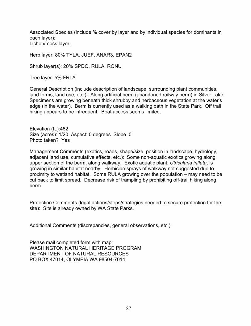
87
Associated Species (include % cover by layer and by individual species for dominants in each layer): Lichen/moss layer: Herb layer: 80% TYLA, JUEF, ANAR3, EPAN2 Shrub layer(s): 20% SPDO, RULA, RONU Tree layer: 5% FRLA General Description (include description of landscape, surrounding plant communities, land forms, land use, etc.): Along artificial berm (abandoned railway berm) in Silver Lake. Specimens are growing beneath thick shrubby and herbaceous vegetation at the water�s edge (in the water). Berm is currently used as a walking path in the State Park. Off trail hiking appears to be infrequent. Boat access seems limited. Elevation (ft.):482 Size (acres): 1/20 Aspect: 0 degrees Slope 0 Photo taken? Yes Management Comments (exotics, roads, shape/size, position in landscape, hydrology, adjacent land use, cumulative effects, etc.): Some non-aquatic exotics growing along upper section of the berm, along walkway. Exotic aquatic plant, Utricularia inflata, is growing in similar habitat nearby. Herbicide sprays of walkway not suggested due to proximity to wetland habitat. Some RULA growing over the population � may need to be cut back to limit spread. Decrease risk of trampling by prohibiting off-trail hiking along berm. Protection Comments (legal actions/steps/strategies needed to secure protection for the site): Site is already owned by WA State Parks. Additional Comments (discrepancies, general observations, etc.): Please mail completed form with map: WASHINGTON NATURAL HERITAGE PROGRAM DEPARTMENT OF NATURAL RESOURCES PO BOX 47014, OLYMPIA WA 98504-7014

88
Hydrocotyle ranunculoides site (purple circle)
Rare plant info redacted. Contact Washington State Parks and Recreation Commission for further information.