Embed Size (px)
DESCRIPTION
RECTIFYING Louisiana CORS Networks with Vertical Datum Requirements November 2012. Stephen Estopinal, P.E., P.L.S. PROBLEMS FACING HEIGHT IN SOUTH LOUISIANA. Subsidence. Network Adjustments (epoch). Geoid Model Updates. GPS DERIVED ORTHOMETRIC HEIGHT (Elevation) - PowerPoint PPT Presentation
Citation preview

RECTIFYINGLouisiana CORS Networks
withVertical Datum Requirements
November 2012
Stephen Estopinal, P.E., P.L.S.


PROBLEMS FACING HEIGHT IN SOUTH LOUISIANA
Subsidence Network Adjustments (epoch)
Geoid Model Updates
GPS DERIVED
ORTHOMETRIC HEIGHT
(Elevation)
The orthometric height is calculated from the ellipsoidal and geoidal separation.

GEOID
Each published Geoid is an
attempt to model Earth’s
equipotential surface
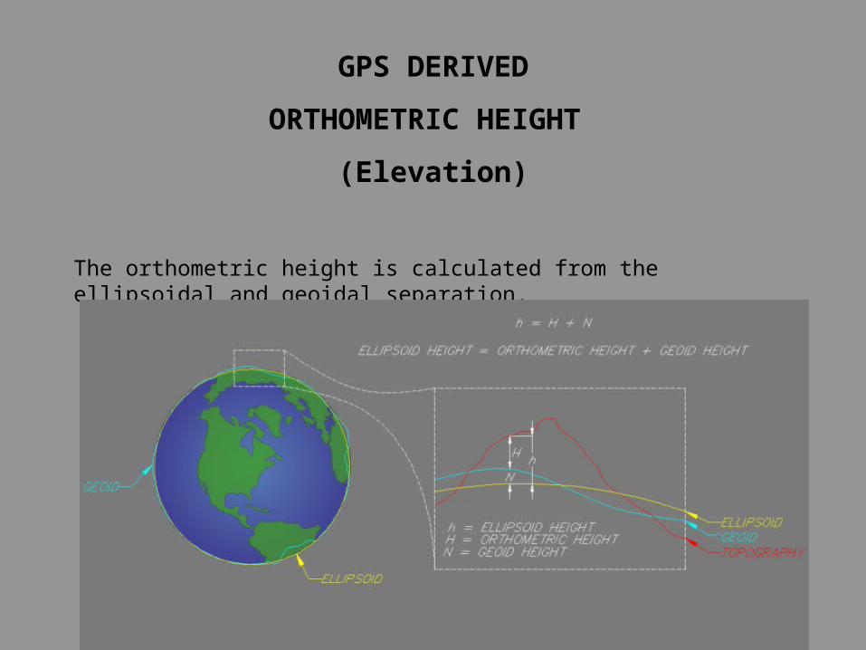
The TED Example
The case for 1 cm level geiod
Height of PBM "TED"
5
5.1
5.2
5.3
5.4
5.5
5.6
5.7
5.8
5.9
6
Height of TED
Hei
gh
t (U
S f
t)
Monument ALCO
Monument C189
Monument REGGIO 2
Monument WasteWell 2 RESET
NGS COR Station
Monuments ALCO,C189, REGIO 2
NGS OPUS
C4GNET
LEICA SMARTNET
ST
AT
IC
ST
AT
IC
ST
AT
IC
ST
AT
IC
ST
AT
IC
ST
AT
IC
ST
AT
IC
RT
N
RT
N

POTENTIAL PROBLEMS

DEEP ROD MARKS
Available to all users;
GPS Equipment optional;
Will monitor deep subsidence
and near surface movement;
Provide platforms for
Absolute Gravity Meters;
Develop research data for
Coastal Restoration designs.

Stephen Estopinal, P.E., P.L.S.
Stephen.Estopinal @ SJBGroup.com
QUESTIONS???
Office (225) 769-3400
Fax (225) 769-3596