Embed Size (px)
Citation preview
Coastal Access | Ramsgate to Whitstable | Natural England’s Proposals | Chapter 4: Reculver to Whitstable Harbour
www.gov.uk/natural-england
Chapter 4:
Reculver to Whitstable HarbourCoastal Access: Ramsgate to Whitstable - Natural England’s Proposals
Part 4.1: Introduction
Start Point: Reculver (grid reference: TR22646931)
End Point: Whitstable Harbour (grid reference: TR10876700)
Relevant Maps: 4a to 4i
Understanding the proposals and accompanying maps:
The Trail:
4.1.1 Generally follows existing walked routes, including public rights of way along most of this length.
4.1.2 Mainly follows the coastline quite closely and maintains good views of the sea.
4.1.3 Follows the route of the Saxon Shore Way regional walking route and/or the Oyster Bay Trail cycle way but departs from these routes in places such as Reculver, Bishopstone and Hampton in order to maintain a walking route closer to the sea, using other existing routes.
4.1.4 This part of the coast includes the following sites, designated for nature conservation or heritage preservation (See map C of the Overview):
Tankerton Slopes and Swalecliffe Special Area of Conservation (SAC)
Thanet Coast and Sandwich Bay Special Protection Area (SPA)
Thanet Coast and Sandwich Bay Ramsar site
Tankerton Slopes Site of Special Scientific Interest (SSSI) for its geological/wildlife interest
Thanet Coast and Sandwich Bay Site of Special Scientific Interest (SSSI) for its geological/wildlife interest.
Reculver Saxon Shore fort, Anglo-Saxon monastery and associated remains (Scheduled Monument).
We have assessed the potential impacts of access along the proposed route (and over the associated spreading room described below) on the features for which the affected land is designated and on any which are protected in their own right.
4.1.5 After advice from specialists we have concluded that our proposals would not be likely to have any significant impact on these features. In reaching this conclusion we have identified that it would be necessary to increase the level of signage on the stretch, alerting walkers to the presence of sensitive sites for roosting birds, turnstone in particular. Better interpretation of the
Coastal Access | Ramsgate to Whitstable | Natural England’s Proposals | Chapter 4: Reculver to Whitstable Harbour
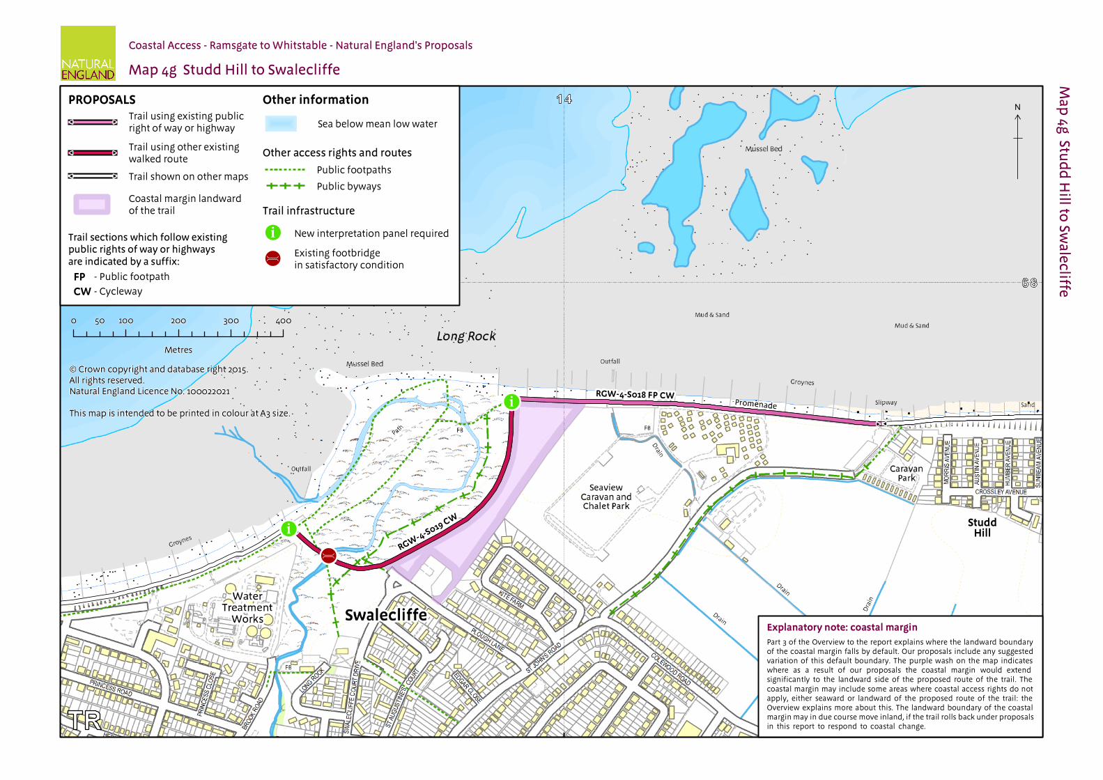
areas, the route of the trail and the sensitivities will also be provided at Swalecliffe (see map 4g). This proposal is explained further in parts 5 & 9 of the Overview.
In relation to those nature conservation sites listed above, refer to our published Access and Sensitive Features Appraisal for more information.
See part 5b of the Overview - ‘Natural environment’ - for more information.
Accessibility
4.1.6 Generally, there are few artificial barriers to accessibility on the proposed route, which makes use of existing surfaced paths wherever these meet the criteria in the Coastal Access Scheme.
However, there are places where it may not be entirely suitable for people with reduced mobility because:
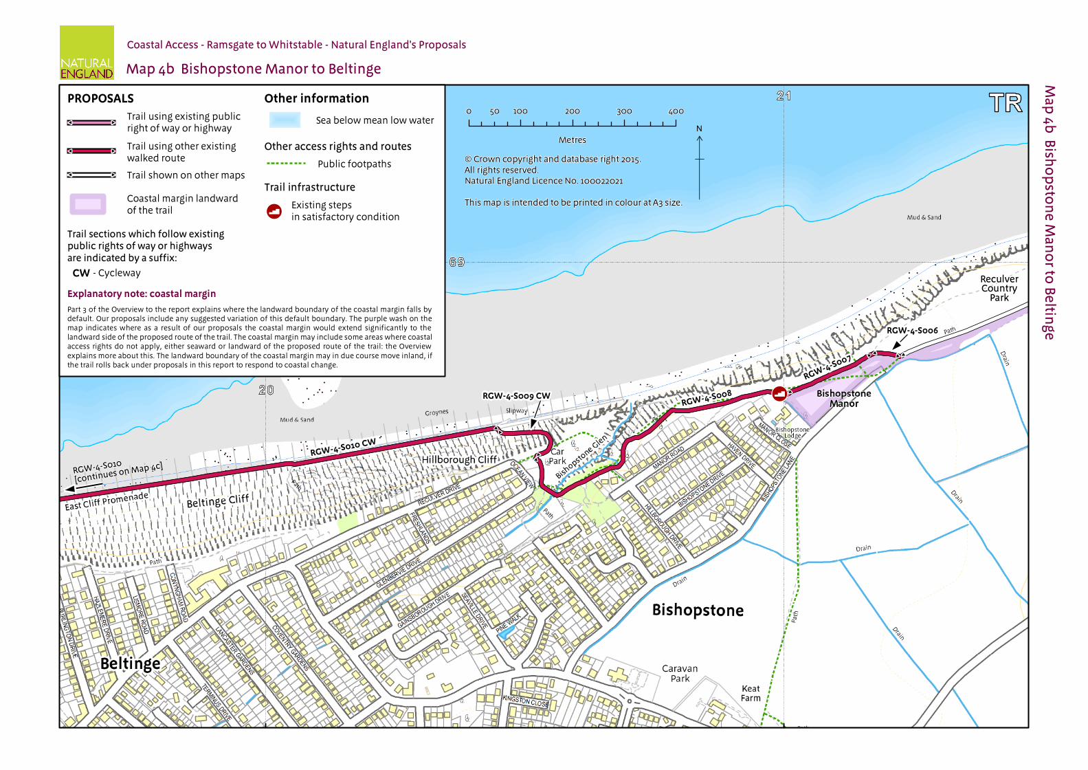
The trail would follow an uneven grass or bare soil path along the cliff top at Bishopstone (sections RGW-4-S006 to RGW-4-S008, map 4b);
There are places where it would be necessary to ascend/descend a slope and some steps to continue the route, such as at Bishopstone (section RGW-4-S009, map 4b)
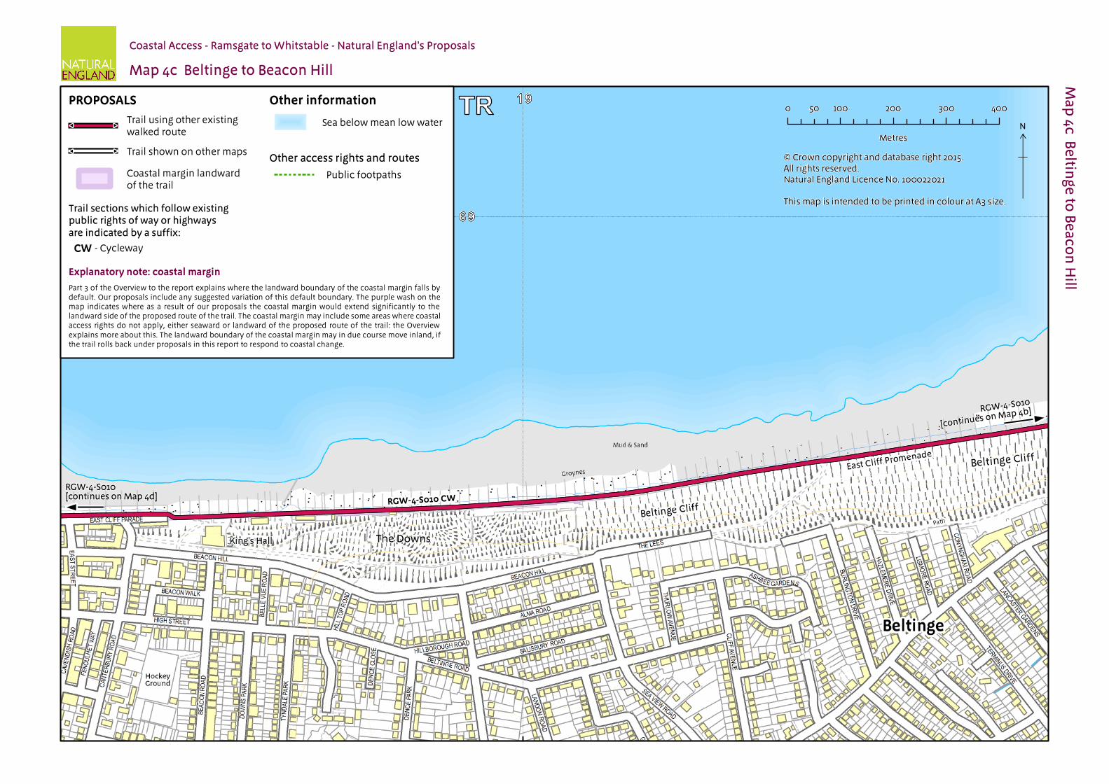
4.1.7 Other factors affecting access: At route section RGW-4-S010 on Herne Bay promenade (see map 4d), public access may be interrupted from time to time for short periods to allow for the closure of flood gates alongside the promenade. It is possible to continue along the roadside pavements in this area when the flood gates are closed. This arrangement would continue without any local restriction on the new access rights to give effect to it formally.
See part 5a of the Overview - ‘Recreational issues’ - for more information.
Where we have proposed exercising our discretion:
The discretions referred to below are explained in more detail in part 5 of the Overview.
4.1.8 Landward boundary of the coastal margin: We have used our discretion on some sections of the route to map the landward extent of the coastal margin to an adjacent physical boundary such as a fence line, pavement or track to make the extent of the new access rights clearer. See Table 4.2.1 below.
4.1.9 In some places, we have used our discretion to propose the inclusion of additional, more extensive landward areas within the coastal margin, to secure or enhance public enjoyment of this part of the coast. The owner of the land is content for us to propose this area.
See also part 3 of the Overview - ‘Understanding the proposals and accompanying maps’, for an explanation of the default extent of the coastal margin and how we may use our discretion to adjust the margin, either to add land or to provide clarity. See also Annex C of the Overview - ‘Excepted land categories’.
4.1.10 Restrictions and/or exclusions: Access rights to the spreading room would be subject to the national restrictions on coastal access rights listed in Annex D of the Overview. These restrictions would not apply to public rights of way.
See part 9 of the Overview - ‘Restrictions and exclusions’ - for details.
4.1.11 Establishment: There are no additional measures that we consider necessary to improve the safety or convenience of the trail on this length of coast.
4.1.12 Ongoing management: Ongoing management and maintenance would be necessary in accordance with the general approach described in part 7 of the Overview.
See parts 6 - ‘Physical establishment of the trail’ and 7 - ‘Maintenance of the trail’ of the Overview for more information.
Coastal Access | Ramsgate to Whitstable | Natural England’s Proposals | Chapter 4: Reculver to Whitstable Harbour
Future Change
4.1.13 Part of the route of the trail on this length of coast would be able to change without further approval from the Secretary of State in response to coastal erosion or other geomorphological processes, or encroachment by the sea. This would happen in accordance with the criteria and procedures for ‘roll back’ set out in part 8 of the Overview. See table 4.2.1 below for details of the sections likely to be affected in the foreseeable future.
4.1.14 At the time of preparing the report, we do not foresee any other need for future changes to the access provisions proposed for the length of coast described in this chapter.
See parts 5e - ‘Coastal processes’ and 8 - ‘Future changes’ of the Overview for more information.
Part 4.2: Commentary on MapsSee Part 3 of Overview for guidance on reading and understanding the tables below
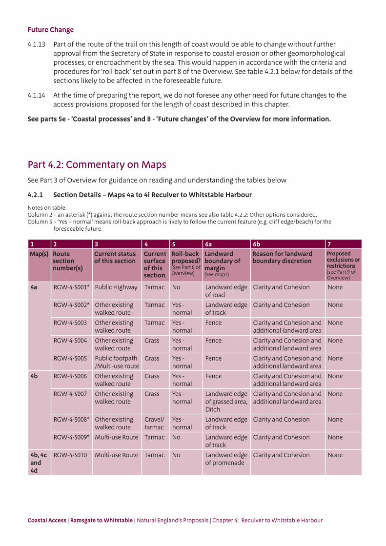
4.2.1 Section Details – Maps 4a to 4i Reculver to Whitstable Harbour
Notes on table:Column 2 – an asterisk (*) against the route section number means see also table 4.2.2: Other options considered.Column 5 – ‘Yes – normal’ means roll-back approach is likely to follow the current feature (e.g. cliff edge/beach) for the
foreseeable future.
1 2 3 4 5 6a 6b 7Map(s) Route
section number(s)
Current status of this section
Current surface of this section
Roll-back proposed?(See Part 8 of Overview)
Landward boundary of margin (See maps)
Reason for landward boundary discretion
Proposed exclusions or restrictions(see Part 9 of Overview)
4a RGW-4-S001* Public Highway Tarmac No Landward edge of road
Clarity and Cohesion None
RGW-4-S002* Other existing walked route
Tarmac Yes - normal
Landward edge of track
Clarity and Cohesion None
RGW-4-S003 Other existing walked route
Tarmac Yes - normal
Fence Clarity and Cohesion and additional landward area
None
RGW-4-S004 Other existing walked route
Grass Yes - normal
Fence Clarity and Cohesion and additional landward area
None
RGW-4-S005 Public footpath /Multi-use route
Grass Yes - normal
Fence Clarity and Cohesion and additional landward area
None
4b RGW-4-S006 Other existing walked route
Grass Yes - normal
Fence Clarity and Cohesion and additional landward area
None
RGW-4-S007 Other existing walked route
Grass Yes - normal
Landward edge of grassed area, Ditch
Clarity and Cohesion and additional landward area
None
RGW-4-S008* Other existing walked route
Gravel/tarmac
Yes - normal
Landward edge of track
Clarity and Cohesion None
RGW-4-S009* Multi-use Route Tarmac No Landward edge of track
Clarity and Cohesion None
4b, 4c and 4d
RGW-4-S010 Multi-use Route Tarmac No Landward edge of promenade
Clarity and Cohesion None

Coastal Access | Ramsgate to Whitstable | Natural England’s Proposals | Chapter 4: Reculver to Whitstable Harbour
1 2 3 4 5 6a 6b 7Map(s) Route
section number(s)
Current status of this section
Current surface of this section
Roll-back proposed?(See Part 8 of Overview)
Landward boundary of margin (See maps)
Reason for landward boundary discretion
Proposed exclusions or restrictions(see Part 9 of Overview)
4e RGW-4-S011 Public Footway (Pavement)
Tarmac No Landward edge of pavement
Clarity and Cohesion None
RGW-4-S012 Public Footway (Pavement)
Tarmac No Landward edge of pavement
Clarity and Cohesion None
RGW-4-S013 Other existing walked route
Tarmac No Landward edge of promenade
Clarity and Cohesion None
RGW-4-S014 Other existing walked route
Tarmac No Landward edge of promenade
Clarity and Cohesion None
4f RGW-4-S015 Public Footway (Pavement)
Tarmac No Landward edge of pavement
Clarity and Cohesion None
RGW-4-S016 Multi-use Route Tarmac No Landward edge of promenade
Clarity and Cohesion None
RGW-4-S017 Public Footpath / Multi-use Route
Tarmac No Landward edge of promenade
Clarity and Cohesion None
4g RGW-4-S018 Public Footpath / Multi-use Route
Tarmac No Landward edge of promenade, Fence
Clarity and Cohesion and additional landward area
None
RGW-4-S019* Multi-use Route Tarmac No Fence, Landward edge of track
Clarity and Cohesion and additional landward area
None
4h and 4i
RGW-4-S020 Multi-use Route Tarmac No Landward edge of promenade
Clarity and Cohesion None
4i RGW-4-S021 Public Footway (Pavement)
Tarmac No Landward edge of pavement
Clarity and Cohesion None
RGW-4-S022 Public Highway Tarmac No Landward edge of trail
Not used None
RGW-4-S023 Public Footway (Pavement)
Tarmac No Landward edge of pavement
Clarity and Cohesion None
RGW-4-S024 Other existing walked route
Tarmac No Landward edge of trail
Not used None

Coastal Access | Ramsgate to Whitstable | Natural England’s Proposals | Chapter 4: Reculver to Whitstable Harbour
4.2.2 Other options considered: Maps 4a to 4i Reculver to Whitstable Harbour
Map(s) Section number(s)
Option(s) considered Reasons for not proposing this option as the route
4a RGW-4-S001 to RGW-4-S002
We considered aligning the trail along the existing public footpath that runs through the car park indicated on the map.
This option would involve walking amongst the parked cars, with no clearly marked walkway.
We opted for the proposed route because:
it follows a safer, defined and surfaced path that is aligned away from the car park.
it maintains views of the sea.
this proposal is made with the support of the landowner.
under our proposals, access to the public footpath, which runs through the busy car park at Reculver, would be unaffected.
we concluded that overall the proposed route struck the best balance in terms of the criteria described in chapter 4 of the Coastal Access Scheme.
4b RGW-4-S008 to RGW-4-S009
We considered aligning the trail to the seaward edge of Bishopstone Glen as shown on the map.
This alignment would include a set of steep steps at the Glen.
We opted for the proposed route because:
it makes use of the level surfaced path around the inland edge of Bishopstone Glen.
it takes advantage of the existing access slope (RGW-4-S009) as opposed to the steps at the mouth of the glen.
public access to the steps at the mouth of the glen would be unaffected by our proposals.
we concluded that overall the proposed route struck the best balance in terms of the criteria described in chapter 4 of the Coastal Access Scheme.
4g RGW-4-S019 We considered aligning the trail along the existing public footpath that runs to the seaward side of the proposed route.
This is an unsurfaced path that crosses an area of wetland nature reserve that has nesting and overwintering birds.
We opted for the proposed route because:
it is flat and surfaced and will improve the accessibility of the trail.
the proposed route avoids those parts of the reserve that support sensitive wildlife.
public access to the footpaths would be unaffected by our proposals.
we concluded that overall the proposed route struck the best balance in terms of the criteria described in chapter 4 of the Coastal Access Scheme.

Coastal Access | Ramsgate to Whitstable | Natural England’s Proposals | Chapter 4: Reculver to Whitstable Harbour
Part 4.3: Chapter 4 - Formal Proposals Below are our formal proposals to the Secretary of State for the length of coast shown on maps 4a to 4i
They should be read in conjunction with the relevant maps.
The commentary above explains the practical effect of these proposals.
Formal Proposals – Reculver to Whitstable Harbour
Proposed route of the trail
4.3.1 In relation to route section RGW-4-S001 and between route sections RGW-4-S009 to RGW-4-S024, the route is to be at the centre of the line shown on maps 4a to 4i as the proposed route of the trail.
4.3.2 In relation to route sections RGW-4-S002 to RGW-4-S008, the route, as initially determined at the time the report was prepared, is to be at the centre of the line shown on maps 4a and 4b as the proposed route of the trail.
4.3.3 If at any time any part of a route section listed in the previous paragraph needs, in Natural England’s view, to change as a result of coastal erosion or other geomorphological processes or encroachment by the sea, in order for the overall route to remain viable, the new route for the part in question will be determined by Natural England without further reference to the Secretary of State. This will be done in accordance with the criteria and procedures described under the title ‘Roll-back’ in part 8 of the Overview and section 4.10 of the Coastal Access Scheme. If this happens, the new route will become the approved route for that section for the purposes of the Order which determines where coastal access rights apply.
Landward boundary of coastal margin
4.3.4 Adjacent to route sections RGW-4-S001 and RGW-4-S002, RGW-4-S008 to RGW-4-S017, RGW-4-S018 and RGW-4-S019 (in parts), RGW-4-S020, RGW-4-S021 and RGW-4-S023 the landward boundary of the coastal margin is to coincide with the landward edge of the promenade, track or pavement shown as the trail on maps 4a to 4i.
4.3.5 Adjacent to route sections RGW-4-S003 to RGW-4-S006 , the landward boundary of the coastal margin is to coincide with the existing fence lines to the landward side of the grassed areas, as indicated by the coastal margin landward of the trail on maps 4a and 4b.
4.3.6 Adjacent to route sections RGW-4-S007, the landward boundary of the coastal margin is to coincide with the landward edge of the grassed area and ditch, as indicated on map 4b.
4.3.7 Adjacent to route sections RGW-4-S018 and RGW-4-S019 (in parts), the landward boundary of the coastal margin is to coincide with the fences indicated on map 4g.
Local restrictions and exclusions
4.3.8 At the time of writing this report, there are no proposals for local restrictions or exclusions in relation to this length of coast.
Refer to Part 9 of the Overview for further details.
Alternative routes
4.3.9 There are no proposals for alternative routes in relation to this length of coast.
#
#
#
#
#
#
#
#
#
#
#
#
#
#
#
#
#
#
#
#
##
#
#
#
#
#
#
#
#
#
#
Other informationPROPOSALS
Explanatory note: coastal margin
#
#
#
#
#
#
RGW-4-S001 RD
RGW-4-S003
RGW-4-S002
RGW-4-S005 FP CW
RGW-4-S004
RD
N
×FPCW
#
#
#
#
#
#
#
#
#
#
##
#
#
#
#
#
#
#
#
##
!(
Other informationPROPOSALS
Explanatory note: coastal margin
#
#
!!
!!
RGW-4-S010 CW
RGW-4-S009 CW
RGW-4-S006
RGW-4-S007
RGW-4-S008
#
#
#
#
N
×CW
#
#
#
#
Other informationPROPOSALS
Explanatory note: coastal margin
#
#
RGW-4-S010 CW
N
×
#
#
CW
#
#
#
#
#
#
Other informationPROPOSALS
Explanatory note: coastal margin
#
#
N
×
RGW-4-S010 CW
#
#
CW
#
#
#
#
#
##
#
#
#
#
##
#
#
#
#
#
#
#
#
#
Other informationPROPOSALS
Explanatory note: coastal margin
#
#
#
#
#
#
FW
RGW-4-S011 FW
RGW-4-S012 FW
RGW-4-S013
RGW-4-S014
N
×

#
#
#
#
#
##
#
#
#
#
#
Other informationPROPOSALS
Explanatory note: coastal margin
#
#
#
#
!ú
!ú
RGW-4-S015 FW
RGW-4-S016 CW
RGW-4-S017 FP CW
N
×
#
#
FP
FW
CW
#
#
#
#
#
#
#
#
#
#
#
#
Other informationPROPOSALS
#
#
#
#
!þ
!þ
!þ
!ú
!ú
RGW-4-S018 FP CW
RGW-4-S019 CW
N
×FP
#
#
CW
Explanatory note: coastal margin
StuddHill

#
#
#
#
#
#
Other informationPROPOSALS
Explanatory note: coastal margin
#
#
RGW-4-S020 CW
N
×
#
#
CW

#
#
#
#
#
#
#
#
#
#
#
#
#
#
#
#
Other informationPROPOSALS
Explanatory note: coastal margin
#
#
#
#
RGW-4-S020 CW
RGW-4-S021 FW
RGW-4-S023 FW
RGW-4-S022 RD
N
×
#
#
RGW-4-S024
RD
FW
CW

![Minimising Harbour Siltation (MHS) - IZW - … below Chart Datum [m] Old Outer Harbour 100 kHz Old Outer Harbour 15 kHz New Outer Harbour 100 kHz New Outer Harbour 15 kHz Old Locks](https://img.pdfslide.net/doc/110x75/5aa108c67f8b9ac67a8b45ec/minimising-harbour-siltation-mhs-izw-below-chart-datum-m-old-outer-harbour.jpg)