Embed Size (px)
Citation preview

Regional GIS Users Group Meeting• Wednesday, February 18th
2009• 10:00 AM - Noon• Amphitheater, C – Level• NEXT MEETING MAY 13• www.atlantaregional.com/rgug

Cooperative Purchase Agreement
• Must decide if you are going to join• Sanborn quote and specs in handout
– Review for changes and make decision– Need verification from counties to continue
• Present to ARC Board as a programmatic element for Calendar year 2010
• USGS contributing
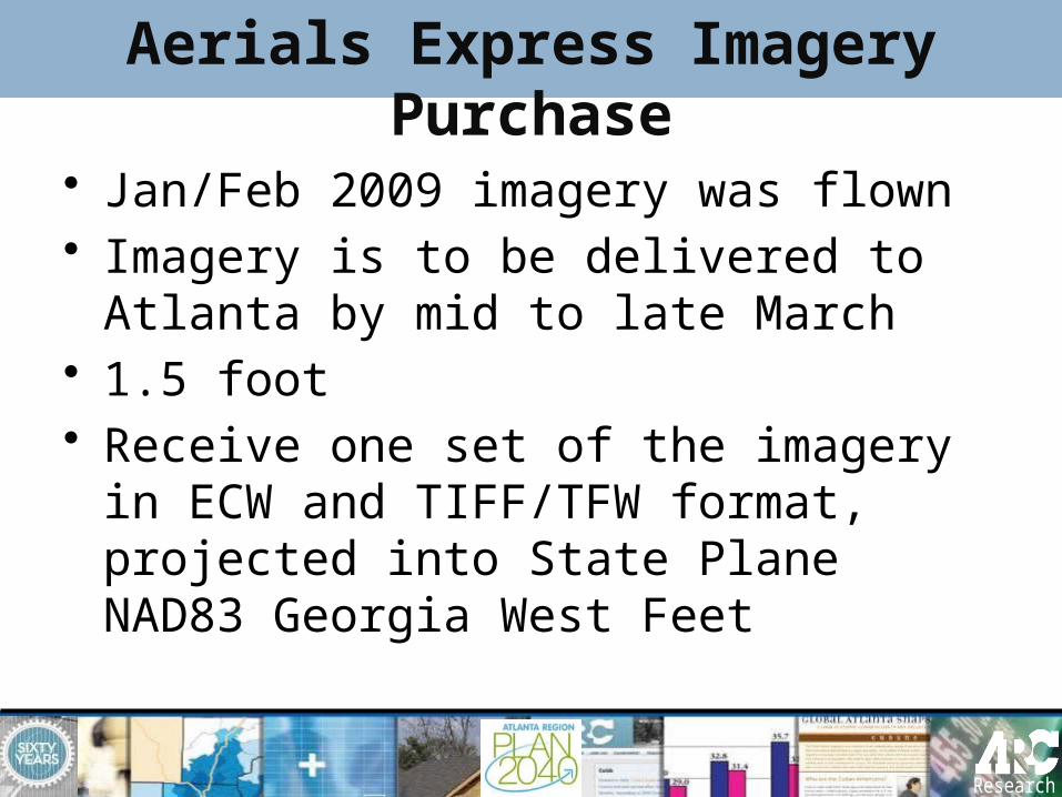
Aerials Express Imagery Purchase
• Jan/Feb 2009 imagery was flown• Imagery is to be delivered to Atlanta
by mid to late March • 1.5 foot • Receive one set of the imagery in
ECW and TIFF/TFW format, projected into State Plane NAD83 Georgia West Feet

Aerials Express Pricing
Number of Participants
• 1
• 2-3
• 4-5
• 6+
Price for Participants
• $17,500
• $15,000
• $12,500
• $10,000
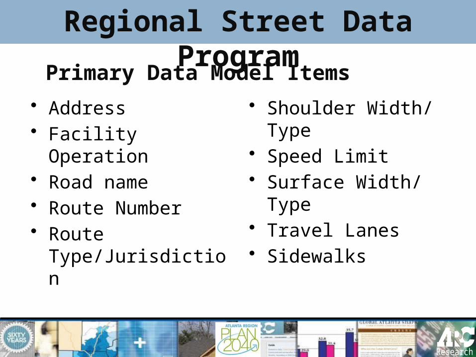
Primary Data Model Items
• Address• Facility Operation• Road name• Route Number• Route
Type/Jurisdiction
• Shoulder Width/ Type
• Speed Limit• Surface Width/
Type• Travel Lanes• Sidewalks
Regional Street Data Program
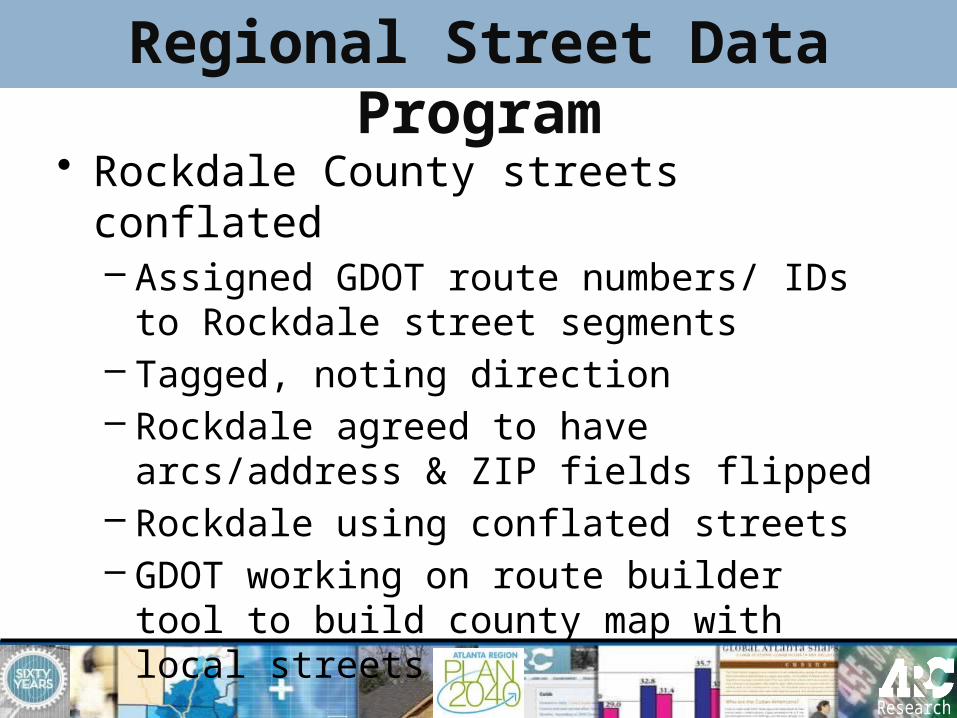
• Rockdale County streets conflated– Assigned GDOT route numbers/ IDs to
Rockdale street segments– Tagged, noting direction– Rockdale agreed to have arcs/address
& ZIP fields flipped– Rockdale using conflated streets– GDOT working on route builder tool to
build county map with local streets
Regional Street Data Program

Conflated Rockdale Streets
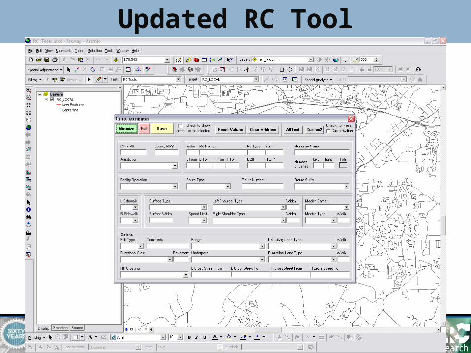
Updated RC Tool

Parallel Street Effort
• Updating Atlanta Region Streets• Requesting street data from
Counties• Can transfer via
http://transfers.atlantaregional.com• Goal to have local street data by
April 1

GIS Training at ARC• ARC has upgraded to the ArcGIS Desktop 9.3 curriculum
• New course outlines, lectures and exercise books• Currently offering ArcGIS Desktop I and II • May add Desktop III next year
• Registration is handled through ARC’s Community Planning Academy • Next class will be ArcGIS Desktop II: Tools and Functionality on March
4-6 • Email class announcements for Desktop II will be going out soon• 3 day class, cost is $340, available to local government staff only (city,
county, water authorities, transit agencies, etc.)• Class size limited to 12 • Please contact Paul DiGirolamo at 404-463-3520 or
[email protected] for more information• Check the Community Planning Academy page of ARC’s website for
upcoming classes and online registration
• Considering adding a Spatial Analyst class, wanted to gauge interest, please let us know if that is something that would be useful
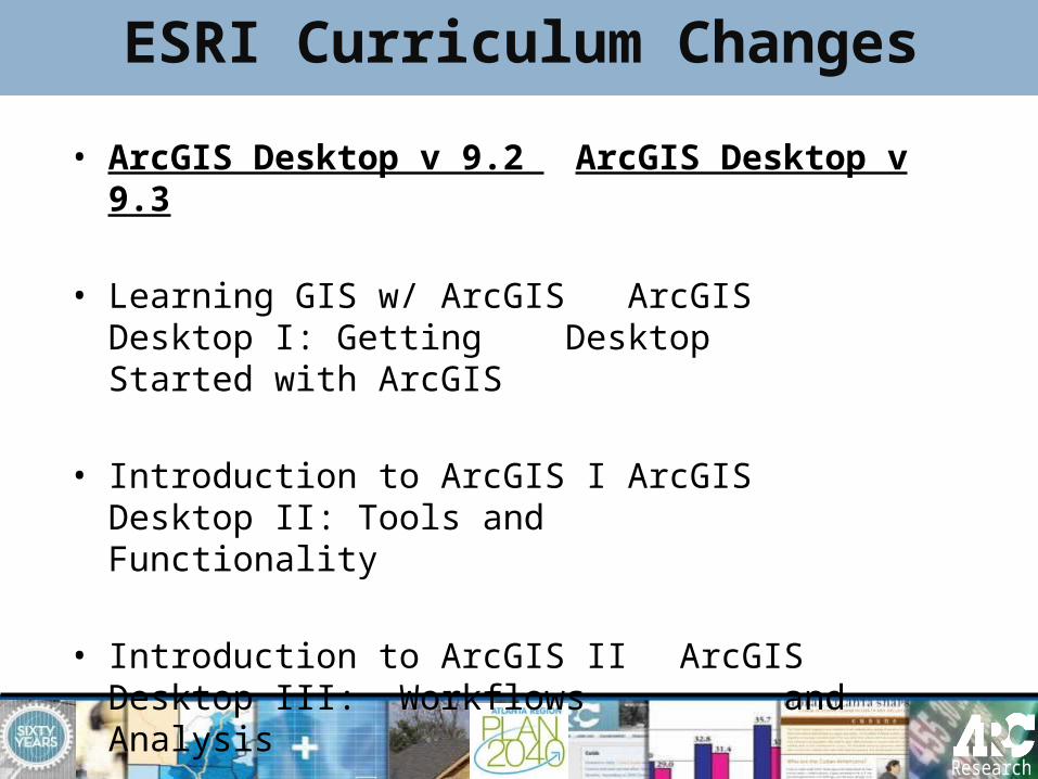
ESRI Curriculum Changes
• ArcGIS Desktop v 9.2 ArcGIS Desktop v 9.3
• Learning GIS w/ ArcGIS ArcGIS Desktop I: Getting Desktop Started with ArcGIS
• Introduction to ArcGIS I ArcGIS Desktop II: Tools and Functionality
• Introduction to ArcGIS IIArcGIS Desktop III: Workflows and Analysis

ArcGIS Server • Migrating from ArcIMS 9.2 to ArcGIS
Server platform– Completed implementation of Latitude
Geographics Geocortex Essentials for ArcGIS Server 9.2
– Upgraded ArcIMS 9.2 to 9.3– Upgraded ArcGIS Server 9.2 to 9.3 and
Geocortex Essentials 1.5.1– Configuration and Internal Testing of GE
application – Geocortex Essentials Training in
Charlotte

• PECAS − Production Exchange Consumption Allocation
System− Developed by Drs Doug Hunt and John Abraham of
University of Calgary− I-O economic model approach − Two Modules, run Sequentially and Annually
• Activity Allocation (HH and Jobs) Module• Space Development Module
− 78 LUZ zones for 20-County model− Landuse forecast− Small area population and employment forecast− Generate input for Travel Demand Model
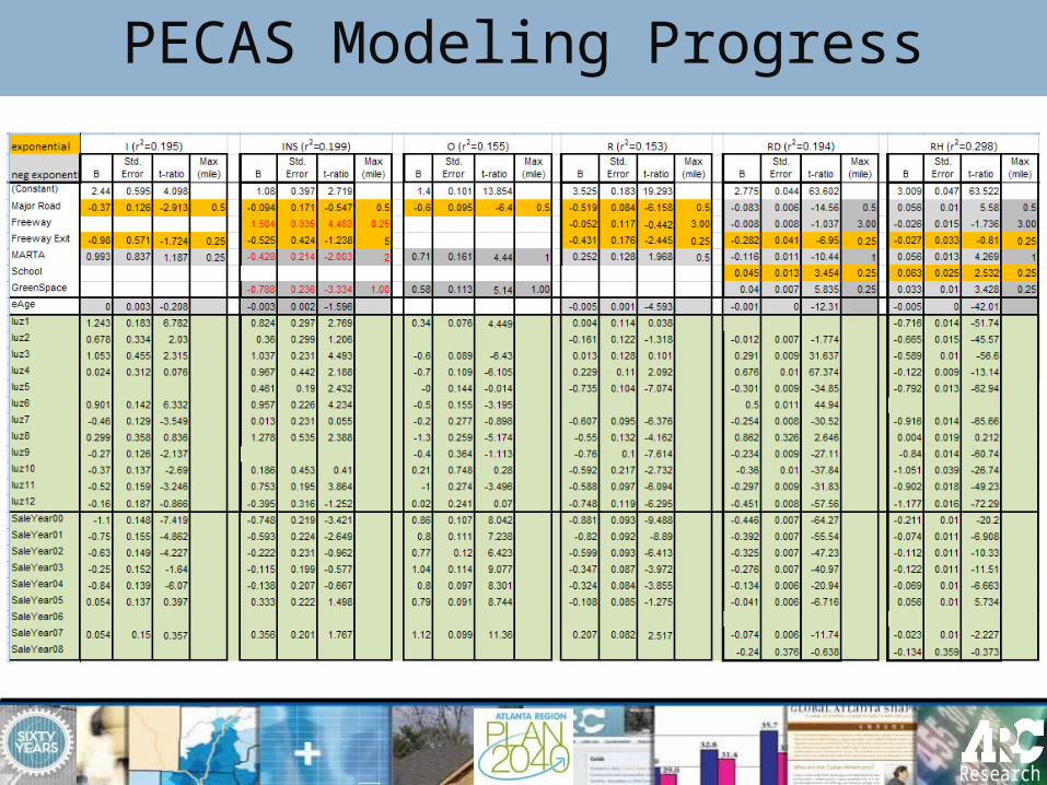
PECAS Modeling Progress

• SD Progress– Build rent equations for Fulton– Build Space Synthesizer for 15 counties– Evaluation and Calibration of Initial
Results from Synthesizer Runs– Migrate SD to PostgreSQL
PECAS Modeling Progress
PECAS Modeling Progress

• AA Progress– Initial Integration with Travel Demand Model
(Skims)– Unconstrained Run in June of 2008– Beginning of 2nd Stage Calibration (Imports
and Exports; Option Sizes)– Development of Constraint Values (Jobs,
Households by Income, Imports/ Exports)– Constrained AA Run October 2008
PECAS Modeling Progress

• Data Development Progress– PUMS ,IMPLAN, SF3 Data Development
for Use with AA– Employment by PECAS category
(industry by occupation by space type)– Development of Space Constraints
Using NAICS Employment and LandPro
PECAS Modeling Progress

• In 2009– Build Synthesizer for remaining 5
counties– Standardize zoning and density layer– Recode ARC SD model– Code rent equations into SD– Floorspace quantity adjustment– Establish Transport Cost Coefficients– Revise Design Diagram– Start calibrating prices from AA
PECAS Modeling Progress
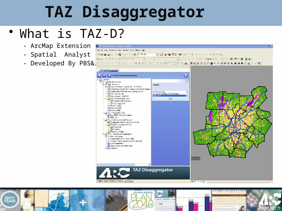
TAZ Disaggregator• What is TAZ-D?
- ArcMap Extension- Spatial Analyst - Developed By PBS&J

TAZ Disaggregator
• What will TAZ-D do?– TAZ level data for Travel Demand Model – Disaggregate future forecast to Super
Districts (78) and TAZs (2024)• -landuse -employment• -household -population
– Improve ARC Zapping procedure• replace FORTRAN programs • Incorporate geospatial factors vs. existing
share based

TAZ Disaggregator
• Major Input data:– REMI forecast– Landpro – Street centerline– Travel impedance matrix– Transit– Parcels– Any geospatial factors

TAZ Disaggregator
• How does TAZ-D disaggregate…?– Apply factors and weighted scores– Spatial Analyst & raster conversion– Calculate and rank the likelihood of
development– Calibration– Allocate the future development– Make animation
TAZ Disaggregator
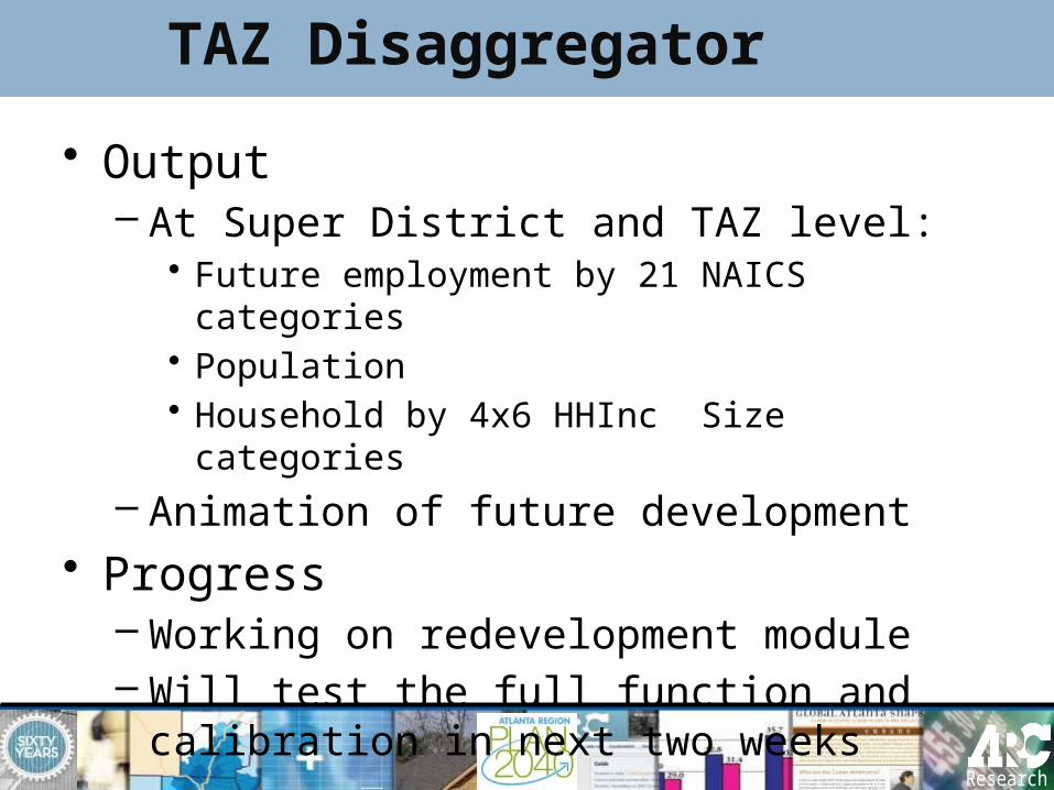
• Output – At Super District and TAZ level:
• Future employment by 21 NAICS categories• Population• Household by 4x6 HHInc Size categories
– Animation of future development• Progress
– Working on redevelopment module– Will test the full function and calibration
in next two weeks

TAZ Disaggregator
Other Announcements
• ARC requesting current City boundaries


![7 L APRIL MEETING NOON SATURDAY, APRIL 10 …sperdvac.com/radiogram/radiogram197604.pdf7 L APRIL MEETING NOON SATURDAY, APRIL 10 '_I/S First Christian Church 18050 Vanowen St.]_' >umm](https://img.pdfslide.net/doc/110x75/5abfd7fa7f8b9a3a428ec162/7-l-april-meeting-noon-saturday-april-10-l-april-meeting-noon-saturday-april.jpg)